DEEPWATER PORT LICENSE APPLICATION FOR THE BLUEWATER SPM PROJECT - VOLUME II - ENVIRONMENTAL EVALUATION Section 2 - Alternatives Analysis
←
→
Page content transcription
If your browser does not render page correctly, please read the page content below
DEEPWATER PORT LICENSE
APPLICATION FOR THE
BLUEWATER SPM PROJECT
VOLUME II – ENVIRONMENTAL EVALUATION

Section 2 – Alternatives Analysis
DEEPWATER PORT LICENSE APPLICATION FOR THE BLUEWATER SPM PROJECT
Volume II: Environmental Evaluation (Public)
Section 2 – Alternatives Analysis

TABLE OF CONTENTS
2      ALTERNATIVES ANALYSIS .................................................................................................................................. 2-1
    2.1        Regulatory Requirements of the Alternatives Analysis ............................................................................ 2-1
    2.2        Framework of the Alternatives Analysis .................................................................................................. 2-5
       2.2.1           Tier I – Evaluation of No Action Alternative .................................................................................... 2-5
       2.2.2           Tier II – Location Alternatives .......................................................................................................... 2-5
       2.2.3           Tier III – Existing Infrastructure vs. New Infrastructure Alternatives .............................................. 2-5
       2.2.4           Tier IV – Siting Analysis of Required Project Components .............................................................. 2-5
       2.2.5           Tier V – Evaluation of Design Alternatives ...................................................................................... 2-5
       2.2.6           Alternatives Analysis Screening Summary....................................................................................... 2-6
    2.3        Tier I – Evaluation of No-Action Alternative............................................................................................. 2-7
    2.4        Tier II – Location Alternatives................................................................................................................... 2-8
       2.4.1           U.S. Region Alternatives .................................................................................................................. 2-8
       2.4.2           State Alternatives .......................................................................................................................... 2-13
       2.4.3           Local Area Alternatives .................................................................................................................. 2-16
    2.5        Tier III – Existing Infrastructure vs. New Infrastructure ......................................................................... 2-27
    2.6        Tier IV – Siting Analysis of Required Project Components ..................................................................... 2-31
       2.6.1           Deepwater Port Site Alternatives .................................................................................................. 2-31
       2.6.2           Pipeline Routing Alternatives ........................................................................................................ 2-35
       2.6.3           Booster Station Location Alternatives ........................................................................................... 2-43
    2.7        Tier V – Evaluation of Design Alternatives ............................................................................................. 2-47
       2.7.1           Deepwater Port Design Alternatives ............................................................................................. 2-47
       2.7.2           SPM Buoy Anchoring Alternatives ................................................................................................. 2-53
    2.8        Alternatives Analysis Summary .............................................................................................................. 2-55
    2.9        Defining the Proposed Project and Alternative Project ......................................................................... 2-57
    2.10       References.............................................................................................................................................. 2-60

LIST OF FIGURES
Figure 2-1: Petroleum Administration for Defense Districts .................................................................................... 2-8
Figure 2-2: Forecasted Increase of U.S. Crude Production Sources Per PADD ........................................................ 2-10
Figure 2-3: Forecasted Increase of U.S. Crude Production Sources Per Source ...................................................... 2-10
Figure 2-4: Existing Major Crude Oil Pipeline Infrastructure in the U.S. by PADD................................................... 2-11
Figure 2-5: Local Area Alternatives .......................................................................................................................... 2-16
Figure 2-6: Existing Offshore Platforms ................................................................................................................... 2-19
Figure 2-7: Texas Coast Location Distances to 85-foot Water Depths .................................................................... 2-20
Figure 2-8: Existing Navigation Fairways and Vessel Densities................................................................................ 2-21
Figure 2-9: Threatened and Endangered Species Critical Habitat ........................................................................... 2-22
Figure 2-10: NAAQS Nonattainment Counties ........................................................................................................ 2-23
Figure 2-11: Planned Major Crude Oil Pipelines ...................................................................................................... 2-25
Figure 2-12: Existing Offshore Platform Infrastructure ........................................................................................... 2-28

                                                                                   2-i                                                          Bluewater SPM Project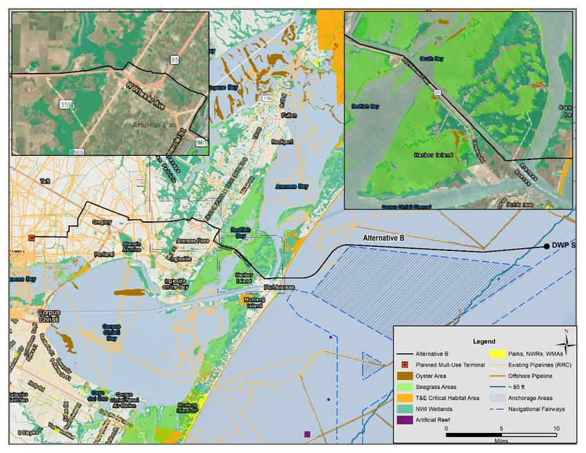
DEEPWATER PORT LICENSE APPLICATION FOR THE BLUEWATER SPM PROJECT
Volume II: Environmental Evaluation (Public)
Section 2 – Alternatives Analysis

Figure 2-13: Existing Offshore Pipeline Infrastructure ............................................................................................ 2-29
Figure 2-14: Evaluated Deepwater Port Locations .................................................................................................. 2-33
Figure 2-15: Pipeline Route Alternatives ................................................................................................................. 2-36
Figure 2-16: Alternative A (DWP Site 1 with Pipeline Route A) ............................................................................... 2-38
Figure 2-17: Alternative B (DWP Site 1 with Pipeline Route B) ............................................................................... 2-39
Figure 2-18: Alternative C (DWP Site 2 with Pipeline Route C) ............................................................................... 2-40
Figure 2-19: Alternative D (DWP Site 2 with Pipeline Route D) ............................................................................... 2-41
Figure 2-20: Booster Station Alternatives................................................................................................................ 2-43
Figure 2-21: Booster Station Alternative 1, 2, 3, and 4............................................................................................ 2-44
Figure 2-22: Single Point Mooring Buoy System General Arrangement.................................................................. 2-48
Figure 2-23: Single Point Mooring Buoy System in Operation ................................................................................ 2-49

LIST OF TABLES
Table 2-1: Alternatives Analysis Overview................................................................................................................. 2-2
Table 2-2: Evaluation of the No Action Alternative Decision Matrix ......................................................................... 2-7
Table 2-3: Crude oil production in the U.S. in 2018 by PADD .................................................................................... 2-9
Table 2-4: Number of Existing Major Crude Oil Pipelines in the U.S. by PADD ....................................................... 2-11
Table 2-5: U.S. Regional Coastal Boundary Mileage ................................................................................................ 2-12
Table 2-6: U.S. Regional Location Alternatives Decision Matrix .............................................................................. 2-12
Table 2-7: Crude Oil Production by State in 2018.................................................................................................... 2-13
Table 2-8: Number of Existing Major Crude Oil Pipeline Infrastructure by State .................................................... 2-14
Table 2-9: State Coastal Boundary Mileage ............................................................................................................. 2-14
Table 2-10: State Alternatives Decision Matrix ....................................................................................................... 2-15
Table 2-11: Existing Gulf Coast Inland Port Draft Restrictions................................................................................. 2-17
Table 2-12: Number of Existing Offshore Platforms ................................................................................................ 2-19
Table 2-13: Distance from Shoreline to 85-foot Water Depth ................................................................................ 2-20
Table 2-14: Texas Coast Location Alternatives T&E Species Critical Habitats ......................................................... 2-23
Table 2-15: Texas Coast Location Alternatives National Ambient Air Quality Standards Status ............................. 2-24
Table 2-16: Number of Existing Major Crude Oil Pipelines by Texas Coast Location .............................................. 2-24
Table 2-17: Number of Planned Major Crude Oil Pipelines by Texas Coast Location ............................................. 2-25
Table 2-18: Number of Phillips 66 Existing/Planned Crude Oil Infrastructure by Texas Coast Location ................. 2-25
Table 2-19: Local Area Location Alternatives Decision Matrix ................................................................................ 2-26
Table 2-20: Existing Infrastructure vs. New Infrastructure Alternatives Decision Matrix ....................................... 2-30
Table 2-21 Deepwater Port Site Alternatives Decision Matrix ................................................................................ 2-34
Table 2-22: Alternative Pipeline Routes and Deepwater Port Location Alternatives Decision Matrix .................... 2-42
Table 2-23 Alternative Booster Station Location Alternatives Decision Matrix ...................................................... 2-46
Table 2-24 Deepwater Port Design Alternatives Decision Matrix ........................................................................... 2-52
Table 2-25 SPM Buoy Anchoring Alternatives Decision Matrix ............................................................................... 2-54
Table 2-26 Alternatives Analysis Summary Table .................................................................................................... 2-55
Table 2-27 Proposed Project and Alternative Project Decision Matrix ................................................................... 2-58

                                                                             2-ii                                                    Bluewater SPM Project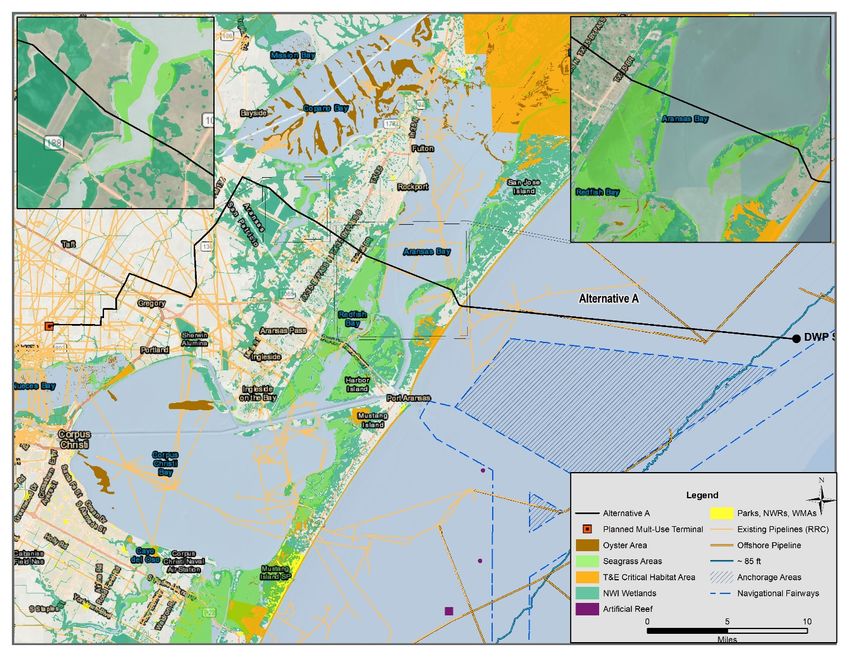
DEEPWATER PORT LICENSE APPLICATION FOR THE BLUEWATER SPM PROJECT
Volume II: Environmental Evaluation (Public)
Section 2 – Alternatives Analysis

ACRONYMS AND ABBREVIATIONS
Applicant   Bluewater Texas Terminal LLC.
Project     Bluewater SPM Project
bph         barrels per hour
BWTT        Bluewater Texas Terminal LLC
CFR         Code of Federal Regulations
DWP         Deepwater Port
DWPA        Deepwater Port Act of 1974
EFH         Essential fish habitat
EIA         Energy Information Administration
ft.         Feet
HDD         horizontal directional drilling
i.e.        Latin for in est, meaning "in other words"
MARAD       Maritime Administration
MHT         Mean high tide
MMbpd       Million barrels per day
NAAQS       National Ambient Air Quality Standards
NEPA        National Environmental Policy Act
PADD        Petroleum Administration for Defense Districts
PADD 1      East Coast Region
PADD 2      Midwest Region
PADD 3      Gulf Coast Region
PADD 4      Rocky Mountain Region
PADD 5      West Coast Region
PLEM        Pipeline end manifold
Project     Bluewater SPM Project
SPM         Single point mooring
T&E         Threatened and Endangered
U.S.        United States of America
VLCC        Very large crude oil carriers
WOUS        Waters of the United States

                                                      2-iii        Bluewater SPM Project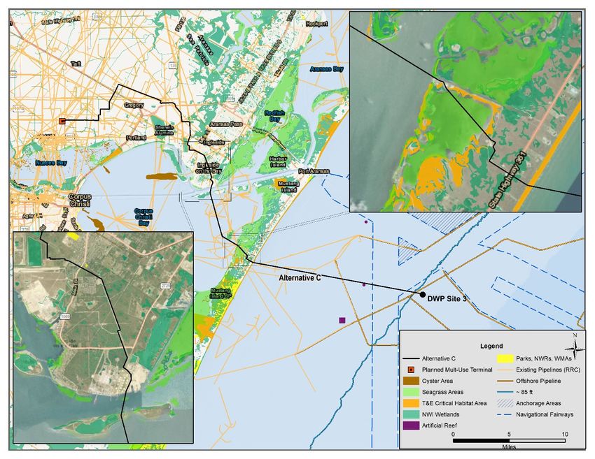
DEEPWATER PORT LICENSE APPLICATION FOR THE BLUEWATER SPM PROJECT
Volume II: Environmental Evaluation (Public)
Section 2 – Alternatives Analysis

2 ALTERNATIVES ANALYSIS
2.1 Regulatory Requirements of the Alternatives Analysis
An analysis of alternatives was undertaken in compliance with the National Environmental Policy Act (NEPA). This
section summarizes the process and outcome of the alternative analysis conducted for the proposed Bluewater
single point mooring (SPM) Project (Project). The alternatives analysis is one of nine criteria used to determine a
final decision under the Deepwater Port Act of 1974, as amended (DWPA) (33 Code of Federal Regulations [CFR]
subchapter NN parts 148, 149, 150 and 33 U.S.C. 1503c). Pursuant to NEPA, governmental decision-makers must
consider a range of reasonable and practicable alternatives to a proposed action that would result in a significant
environmental effect. A reasonable alternative is defined by the below criteria:

        •    Satisfy the Project purpose and need as defined in Section 1 – Project Purpose and Need;
        •    Satisfy Project objectives discussed as defined in Section 1 – Project Purpose and Need;
        •    Technically and economically feasible; and,
        •    Would result in an acceptable return on the investment.

Under the DWPA and in accordance with the implementing regulations in 33 CFR subchapter NN (parts 148, 149,
150), the Maritime Administration (MARAD) may approve or deny an application for a license to construct, own,
operate a Deepwater Port (DWP). Bluewater Texas Terminal LLC (BWTT; also referred to as Applicant) understands
that a license approval may include enforceable conditions by MARAD as part of the license. MARAD may also
consider alternative means to construct and operate the DWP that meet the criteria listed above. Identifying and
evaluating alternatives ensures that decisions using the NEPA process regulated under the DWPA are in the best
interest of the United States, and consistent with national security, energy policies, and environmental policies.

As described in Section 1.0 – Project Purpose and Need, the Applicant identified critical Project objectives required
for the fulfillment of the purpose and need of the proposed Project, which is to provide a safe and environmentally
sustainable solution for the export of abundant domestic crude oil supply from major shale basins. These Project
objectives serve as the basis for consideration throughout the alternatives analysis and are used to compare
potential alternatives throughout a tiered analysis. The overall Project objectives are defined as follows:

Project Objectives

    •       Provide a safe and environmentally sustainable solution for the export of abundant domestic crude oil
            supply from major shale basins and support economic growth in the U.S.
    •       Ability to safely and fully load a Very Large Crude Oil Carrier (VLCC).
    •       Ability of infrastructure to support the simultaneous full loading of up to two (2) VLCC vessels.
    •       Ability of infrastructure to support loading rates of approximately 80,000 barrels per hour (bph) for the full
            loading of up to 16 VLCC’s per month in order to result in an acceptable return on investments.
    •       Minimize the required modifications to existing environmental conditions.
    •       Minimize potential interference with existing natural processes.
    •       Maximize offsite fabrication in a controlled setting thereby minimizing offshore impact as a result of on-site
            construction activities.
    •       Locate Project in proximity to existing and planned crude oil infrastructure in order to reduce footprint
            and environmental impacts.
    •       Minimize impact to waters of the U.S. (WOUS), including wetlands, coastal bend ecosystems, and special
            aquatic resources.
    •       Minimize impact to threatened and endangered (T&E) species and their associated habitats.
    •       Minimize impact to cultural resources.

                                                             2-1                                       Bluewater SPM Project
DEEPWATER PORT LICENSE APPLICATION FOR THE BLUEWATER SPM PROJECT
Volume II: Environmental Evaluation (Public)
Section 2 – Alternatives Analysis

    •     Minimize impact to navigation and navigation safety.
    •     Minimize impact to commercial and recreational fisheries and essential fish habitat (EFH).
    •     Existing land use compatibility, availability, and suitability for the Project.

This alternatives analysis evaluates the reasonable and practicable alternatives in accordance with NEPA. A variety
of practicable and reasonable alternatives were considered by the Applicant. Impracticable alternatives are defined
as alternatives that are technically or economically unfeasible; therefore, were not considered as part of this
alternative analysis.

The alternatives evaluated have been selected to determine the best means of satisfying the purpose and need of
the Project and in accordance with NEPA requirements. As part of the alternative analysis process, the Applicant
identified five tiers which were used to determine the proposed action and a reasonable alternative to the proposed
action, both of which fulfill the purpose and need of the proposed Project. As a result of this alternatives analysis,
the identified proposed action and reasonable alternative to the proposed action will be carried forward for further
evaluation as part of the Environmental Evaluation conducted for the proposed Project to identify related
environmental consequences and their level of impact to the environmental resources. An overview of the
alternative analysis conducted for the proposed Project is shown in Table 2-1:

                                      Table 2-1: Alternatives Analysis Overview
                                                      Alternatives Analysis                                Selection

                                             Tier I Screening: No-Action Alternative

                                                                                                      Not considered for
  No-Action Alternative                               No-Action Alternative
                                                                                                       further review.

                                             Tier II Screening: Location Alternatives

                                                       East Coast (PADD 1)

                                                       Midwest (PADD 2)

 U.S. Region Alternatives                              Gulf Coast (PADD 3)                            Gulf Coast (PADD 3)

                                                   Rocky Mountain (PADD 4)

                                                      West Coast (PADD 5)

                                                            Alabama

                                                            Arkansas

   Gulf Coast (PADD 3)                                      Louisiana
                                                                                                            Texas
    State Alternatives                                     Mississippi

                                                          New Mexico

                                                              Texas

                                                     Sabine/Beaumont Area

                                                          Houston Area

  Texas Coast Location                                    Freeport Area
                                                                                                      Corpus Christi Area
      Alternatives                                      Matagorda Area

                                                       Corpus Christi Area

                                                        Brownsville Area

                                 Tier III Screening: Existing Infrastructure vs. New Infrastructure

                                        Existing Pipeline and/or Platform Infrastructure

                                                                2-2                                    Bluewater SPM Project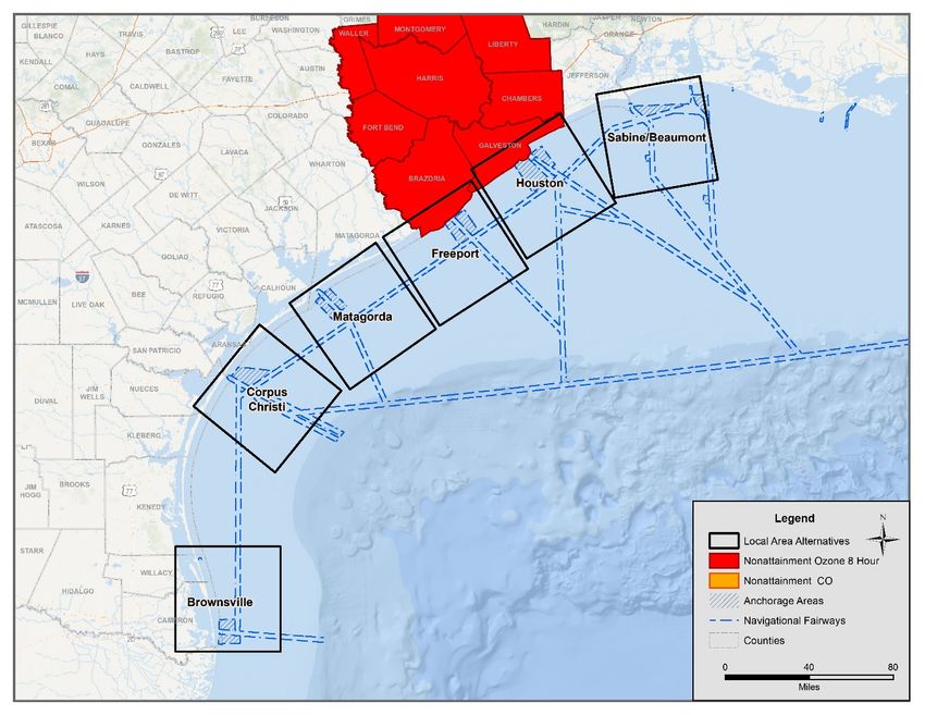
DEEPWATER PORT LICENSE APPLICATION FOR THE BLUEWATER SPM PROJECT
Volume II: Environmental Evaluation (Public)
Section 2 – Alternatives Analysis

                                                                 Alternatives Analysis                                              Selection

                                              Installation of New Offshore Pipeline Infrastructure                              Installation of New
     Infrastructure
                                                                                                                                 Offshore Pipeline
      Alternatives
                                                                                                                                   Infrastructure

                                       Tier IV Screening: Siting Analysis of Required Project Components

                                                                 DWP Site Alternative 1                                    DWP Site Alternative 1

    Deepwater Port                                               DWP Site Alternative 2
  Location Alternatives                                          DWP Site Alternative 3
                                                                                                                           DWP Site Alternative 3
                                                                 DWP Site Alternative 4

                                                  Alternative A (DWP Site 1 with Pipeline Route A)                        Alternative B (DWP Site 1
                                                  Alternative B (DWP Site 1 with Pipeline Route B)                         with Pipeline Route B)
    Pipeline Routing
      Alternatives                                Alternative C (DWP Site 3 with Pipeline Route C)                        Alternative C (DWP Site 3
                                                  Alternative D (DWP Site 3 with Pipeline Route D)                         with Pipeline Route C)

                                                           Booster Station Alternative 1                                         Booster Station
                                    DWP Site 1/Pipeline Route A with Booster Station Location Alternative 1                       Alternative 1
                                                                                                                               DWP Site 1/Pipeline
                                                           Booster Station Alternative 2                                       Route A with Booster
                                                                                                                                 Station Location
                                    DWP Site 1/Pipeline Route A with Booster Station Location Alternative 2
     Booster Station                                                                                                               Alternative 1
  Location Alternatives                                    Booster Station Alternative 3                                         Booster Station
                                    DWP Site 3/Pipeline Route C with Booster Station Location Alternative 3                       Alternative 3
                                                                                                                                DWP Site 3/Pipeline
                                                           Booster Station Alternative 4                                       Route C with Booster
                                                                                                                                 Station Location
                                    DWP Site 3/Pipeline Route C with Booster Station Location Alternative 4
                                                                                                                                   Alternative 3

                                              Tier V Screening: Evaluation of Design Alternatives

 Deepwater Port Design                                              Fixed Platform                                             Single-Point Mooring
     Alternatives                                       Single-Point Mooring Buoy System                                           Buoy System

                                                                     Drag Anchors
  SPM Buoy Anchoring
                                                                    Gravity Anchors                                                Anchor Piles
     Alternatives
                                                                      Anchor Piles

                                            Alternatives Carried Forward for Further Consideration

                          Alternative Project A                                                        Alternative Project B

    Deepwater Port Location                                                        Deepwater Port Location
                                          DWP Site Alternative 1                                                        DWP Site Alternative 3
         Alternatives                                                                   Alternatives

                                       Alternative B (DWP Site 1 with                                               Alternative C (DWP Site 3 with
  Pipeline Routing Alternatives                                                  Pipeline Routing Alternatives
                                             Pipeline Route B)                                                            Pipeline Route C)

                                       Booster Station Alternative 1                                                 Booster Station Alternative 3
    Booster Station Location           DWP Site 1/Pipeline Route A                 Booster Station Location         DWP Site 3/Pipeline Route C
         Alternatives                  with Booster Station Location                    Alternatives                with Booster Station Location
                                               Alternative 1                                                                Alternative 3

    Deepwater Port Design                  Single-Point Mooring                      Deepwater Port Design               Single-Point Mooring
        Alternatives                           Buoy System                               Alternatives                        Buoy System

      SPM Buoy Anchoring                                                              SPM Buoy Anchoring
                                                  Anchor Piles                                                                 Anchor Piles
         Alternatives                                                                    Alternatives

                                                                           2-3                                                   Bluewater SPM Project
DEEPWATER PORT LICENSE APPLICATION FOR THE BLUEWATER SPM PROJECT
Volume II: Environmental Evaluation (Public)
Section 2 – Alternatives Analysis

For each tier of the alternative analysis, a four-step process was used for the screening of potential alternatives to
determine which best fulfilled the Project purpose and need and Project objectives. During this process, alternatives
were eliminated to allow for the advancement of the most practicable alternatives for further consideration and
analysis in subsequent tiers. The four-step process followed for each tier includes:

    1.   Identification and description of reasonable and practicable alternatives for analysis
    2.   Development of selection criteria for evaluating reasonable alternatives
    3.   Evaluation and comparison of reasonable alternatives based on selection criteria
    4.   Identification of most-suitable alternatives for advancement and evaluation in subsequent tiers

The development of selection criteria during step 2 for the evaluation of alternatives conducted during step 3 is
based upon the Environmental and Project objectives described above. This alternatives locations for the siting of
the necessary components associated with the Project were evaluated in accordance with 33 CFR Part §148.715(b)
siting criteria, as applicable, including:

    •    (a) Optimizes location to prevent or minimize detrimental environmental effects
    •    (b) Minimizes space needed for safe and efficient operation
    •    (c) Locates offshore components in areas with stable sea bottom characteristics
    •    (d) locates onshore components where stable foundations can be developed
    •    (e) Minimizes the potential for interference with its safe operations from existing offshore structures and
         activities
    •    (f) Minimizes danger posed to safe navigation by surrounding water depths and currents
    •    (g) Avoids extensive dredging or removal of natural obstacles such as reefs
    •    (h) Minimizes the danger to the port, its components, and tankers calling at the port from storms,
         earthquakes, or other natural hazards
    •    (i) Maximizes the permitted use of existing work areas, facilities, and access routes
    •    (j) Minimizes the environmental impact of temporary work areas, facilities, and access routes
    •    (k) Maximizes the distance between the port, its components, and critical habitats including commercial
         and sport fisheries, threatened or endangered species habitats, wetlands, flood plains, coastal resources,
         marine management areas, and essential fish habitats
    •    (l) Minimizes the displacement of existing or potential mining, oil, or gas exploration and production or
         transportation uses
    •    (m) Takes advantage of areas already allocated for similar use, without overusing such areas
    •    (n) Avoids permanent interference with natural processes or features that are important to natural currents
         and wave patterns
    •    (o) Avoids dredging in areas where sediments contain high levels of heavy metals, biocides, oil or other
         pollutants or hazardous materials, and in areas designated wetlands or other protected coastal resources
Section 2.2 provides a summary of the alternatives analysis framework and details the basis on which the identified
tiers used for analysis were developed.

                                                         2-4                                       Bluewater SPM Project
DEEPWATER PORT LICENSE APPLICATION FOR THE BLUEWATER SPM PROJECT
Volume II: Environmental Evaluation (Public)
Section 2 – Alternatives Analysis

2.2 Framework of the Alternatives Analysis
As previously described, the alternatives analysis conducted for the proposed Project follows a tiered screening
approach to identify and analyze potential alternatives and their ability to meet the Project purpose and need and
Project objectives. As a result of the alternatives analysis, a total of six tiers were identified.

Tier I consisted of the evaluation of the no action alternative. Based on the results of Tier I, the need for action was
determined. As such an analysis of potential location alternatives was conducted (Tier II), followed by existing
infrastructure vs. new infrastructure alternatives (Tier III), siting analysis of required Project components (Tier IV),
and evaluation of design alternatives (Tier V). The following sections detail the basis on which each of the identified
tiers were developed based on preceding determinations.

2.2.1 Tier I – Evaluation of No Action Alternative
Tier I of the alternatives analysis process evaluated the no action alternative. The no action alternative refers to the
continuation of existing conditions without implementation of the proposed Project. Based on the results of the Tier
I screening, the overall need for the proposed Project was determined with respect to existing market conditions
and future crude oil production.

2.2.2 Tier II – Location Alternatives
Based on the results of the Tier I screening analysis, a Tier II screening was conducted consisting of an evaluation of
locations within the United States of America (U.S.) that is most suited for meeting the Project purpose and need.
As part of Tier II of the alternatives analysis, forecast of crude oil production was analyzed to determine the most
suitable setting for the Project. The most suitable setting is further refined through the analysis of navigation and
navigational safety needs, existing land use and infrastructure, and presence of sensitive ecological resources.
Completion of the Tier II screening resulted in the selection of a regional setting for the proposed Project.

2.2.3 Tier III – Existing Infrastructure vs. New Infrastructure Alternatives
Based on the regional location determined as a result of the Tier II screening analysis, Tier III screening was
conducted to evaluate the technical feasibility for the utilization of existing offshore infrastructure to fulfill the
Project purpose and need. The construction of new infrastructure as well as the utilization of existing infrastructure
was investigated as part of the Tier III screening. The Tier III screening resulted in the determination of the most
suitable conceptual project configuration and the required components. As such, the completion of the Tier III
screening allows for a more specific siting analysis of the necessary components to be conducted during the Tier IV
screening.

2.2.4 Tier IV – Siting Analysis of Required Project Components
The Tier III screening resulted in the development of a conceptual design and understanding of the required Project
components which are required to fulfill the Project purpose and need. This understanding of the required
infrastructure allows for a detailed siting analysis to be conducted for each of the necessary Project components to
determine the preferred locations with regards to various siting criteria. As a result of the Tier IV analysis, two
alternative Project configurations were carried forward for further analysis. The results of the Tier IV siting analysis
allow for the further refinement of the conceptual project design and more detailed engineering of the various
components associated with the proposed Project to be completed during the Tier V screening.

2.2.5 Tier V – Evaluation of Design Alternatives
The Tier V screening consisted of the analysis of the potential alternative project designs for the various components
associated with the proposed Project. As part of this screening, each of the required components were analyzed to
determine which allowed for the necessary throughput capacities and fulfillment of Project goals and objectives,

                                                          2-5                                       Bluewater SPM Project
DEEPWATER PORT LICENSE APPLICATION FOR THE BLUEWATER SPM PROJECT
Volume II: Environmental Evaluation (Public)
Section 2 – Alternatives Analysis

while minimizing impacts and overall Project footprint to the maximum extent practicable. The selected design
alternative was applied to both alternatives carried forward as a result of the Tier IV analysis.

2.2.6 Alternatives Analysis Screening Summary
Based on the results of the five-tiered screening process detailed above, two Project alternatives were identified as
practicable alternatives to fulfill the Project purpose and need. This section of the alternatives analysis provides a
comparative analysis of identified alternatives to define a “Proposed Project” and an “Alternative Project” based on
previous screening criteria based on the ability to fulfill Project goals and objectives while minimizing environmental
impacts to the maximum extent practicable. The Preferred Project and Alternative Project are both carried forward
for further evaluation as part of the Environmental Evaluation conducted for the proposed Bluewater SPM Project
to identify related environmental consequences and their level of impact to environmental resources as a result of
the construction, operation, and decommissioning of the Project components.

                                                          2-6                                      Bluewater SPM Project
DEEPWATER PORT LICENSE APPLICATION FOR THE BLUEWATER SPM PROJECT
Volume II: Environmental Evaluation (Public)
Section 2 – Alternatives Analysis
2.3 Tier I – Evaluation of No-Action Alternative
The no action alternative refers to the continuation of existing conditions without implementation of the proposed
Project. According to the U.S. Energy Information Administration (EIA) 2019 Annual Energy Outlook, total U.S. crude
oil production reached an average of 10.8 million barrels per day (MMbpd) in 2018. By 2030, U.S. crude oil
production is expected to increase by 3.7 MMbpd. The primary projected increase is that of crude oil classified as
light crude oil which is defined as consisting of a density measured in American Petroleum Institute (API) gravity of
greater than 35 degrees API. Light crude oil is projected to account for almost 81% (3.7 MMbpd) of the increase.
Most of the light oil production growth is projected to occur within the Southwest region (Texas and New Mexico)
at additional volumes of 2.2 MMbpd by 2030.
Current U.S. refineries are configured to process heavy and high sulfur crude oil supplies which are generally derived
from international producers such as Canada, South America, and the Middle East. Running U.S. refineries solely on
domestic light crude oil or reconfiguring the capabilities of any refinery is generally uneconomical.
Current and projected crude oil production indicate that the U.S. will become a net exporter of crude oil by 2020.
Additionally, the U.S. has more sweet crude oil than it can refine domestically and therefore is needing an efficient
export solution to international markets that have the necessary refining infrastructure and growing demand.
Current U.S. crude oil export logistics are constrained and rely upon inefficient means resulting in significant
economic disadvantages, potential navigational concerns, and exposure to workforce hazards.
Under the no-action alternative, the export of crude oil from the U.S. would be limited to existing operations and
constraints. The no-action alternative would limit current and future crude oil production and opportunity for the
U.S. capitalization on international market demands and economic growth. Table 2-2 presents the analysis of Tier I
evaluation.
Table 2-2: Evaluation of the No Action Alternative Decision Matrix
No Action
Objective Type Objectives Action
Alternative
Provide a safe and environmentally sustainable solution for the export of
abundant domestic crude oil supply from major shale basins and support X
economic growth in the U.S.
Ability to safely and fully load a VLCC. X
Project Objectives
Ability of infrastructure to support the simultaneous full loading up to
X
two (2) VLCC vessels.
Ability of infrastructure to support loading rates of approximately 80,000
X
bph for the full loading of up to 16 VLCC’s per month.
TOTAL 0 4
Tier I – No Action Alternatives Analysis Conclusion
Based on the results of the Tier I analysis, as presented in Table 2-2, the no-action alternative was not
considered feasible and not considered for further review.
2-7 Bluewater SPM ProjectDEEPWATER PORT LICENSE APPLICATION FOR THE BLUEWATER SPM PROJECT
Volume II: Environmental Evaluation (Public)
Section 2 – Alternatives Analysis
2.4 Tier II – Location Alternatives
As determined by the result of the Tier I screening analysis, the Applicant determined the need for the development
of a safe and environmentally sustainable solution for the export of abundant domestic crude oil supply from major
shale basins and support economic growth in the U.S.
Tier II of the alternatives analysis evaluates locations within the U.S. most suited for meeting the Project purpose
and need. Tier II analyzes location alternatives at the U.S. Regional level, state level, and local area level. The
following sections describe the alternatives analyzed and the respective results of the Tier II screening analysis.
2.4.1 U.S. Region Alternatives
The U.S. is divided into five regions called Petroleum Administration for Defense Districts (PADDs) as shown in Figure
2-1. PADDs are geographic aggregations which were established during World War II to help organize and ration
petroleum products being used as fuel such as gasoline and diesel. PADDs are used today to analyze patterns of
crude oil and petroleum product movements throughout the U.S. (EIA 2019c). The five PADDs are:
• East Coast (PADD 1)
• Midwest (PADD 2)
• Gulf Coast (PADD 3)
• Rocky Mountain (PADD 4)
• West Coast (PADD 5)
Figure 2-1: Petroleum Administration for Defense Districts
Source: EIA 2019
2-8 Bluewater SPM ProjectDEEPWATER PORT LICENSE APPLICATION FOR THE BLUEWATER SPM PROJECT
Volume II: Environmental Evaluation (Public)
Section 2 – Alternatives Analysis
The analysis of U.S. Regional location alternatives was based upon three screening criteria consisting of the following:
1. High Crude Oil Production: Establishment of a crude oil export solution within the regional location of the
highest crude oil production.
2. Amount of Existing Crude Oil Transport Infrastructure: Establishment of a crude oil export solution within
the regional location with existing crude oil transport infrastructure (i.e. pipelines) allows for connectivity
and utilization of existing infrastructure. This, consequently, is cost-effective, promotes operational
efficiencies, and minimizes the need for additional infrastructure.
3. Regional Coastal Boundary: The most efficient form of export of crude oil from the U.S. is conducted via
waterborne commerce. As such, access to coastal waters is required for the loading of vessels for export.
The following sections detail the analysis conducted for the U.S. Regional location alternatives.
High Crude Oil Production
As shown in Table 2-3, 2018 crude oil production volume within the Gulf Coast region (PADD 3) was by far the highest
when compared to all other PADDs. As shown in Figure 2-2, the Gulf Coast region (PADD 3), stands out as
experiencing the highest projected surge in oil production over the next 40 years. Recent growth in U.S. crude oil
production has been driven by the development of tight (shale) oil resources, primarily in the Permian Basin. Three
major tight oil plays in the Permian Basin—the Spraberry, Bone Spring, and Wolfcamp—accounted for 36% of U.S.
tight oil production in 2018. Production from these three plays is projected to increase and to account for 43% of
cumulative tight oil production through 2050 in the Reference case (Figure 2-3).
Table 2-3: Crude oil production in the U.S. in 2018 by PADD
Crude oil production in the U.S. in 2018 by PADD
East Coast (PADD 1) 18,156 thousand bpd
Midwest (PADD 2) 634,514 thousand bpd
Gulf Coast (PADD 3) 2,138,715 thousand bpd
Rocky Mountain (PADD 4) 261,404 thousand bpd
West Coast (PADD 5) 360,587 thousand bpd
Source: EIA.gov
2-9 Bluewater SPM ProjectDEEPWATER PORT LICENSE APPLICATION FOR THE BLUEWATER SPM PROJECT
Volume II: Environmental Evaluation (Public)
Section 2 – Alternatives Analysis
Figure 2-2: Forecasted Increase of U.S. Crude Production Sources Per PADD
Source: EIA 2019
Figure 2-3: Forecasted Increase of U.S. Crude Production Sources Per Source
2-10 Bluewater SPM ProjectDEEPWATER PORT LICENSE APPLICATION FOR THE BLUEWATER SPM PROJECT
Volume II: Environmental Evaluation (Public)
Section 2 – Alternatives Analysis
Amount of Existing Crude Oil Transport Infrastructure
Areas of high crude oil production commonly have a number of major crude oil transport pipelines. As shown in
Table 2-4 and Figure 2-4, the Gulf Coast region (PADD 3) and the Midwest region (PADD 2) have multiple existing
major crude oil pipelines.
The export of domestic crude oil relies on the ability to transport crude oil from the production location to the export
location. As such, the establishment of a crude oil export solution within an area containing existing crude oil
pipelines allows for the necessary connectivity to areas of high crude oil production through the utilization of existing
infrastructure, thereby promoting operational efficiencies. Furthermore, the positioning of a crude oil export
solution within an area of numerous existing crude oil pipelines minimizes the need for the installation of additional
transport infrastructure potentially resulting in additional environmental impacts.
Table 2-4: Number of Existing Major Crude Oil Pipelines in the U.S. by PADD
PADD Area Number of Major Crude Oil Pipelines
East Coast (PADD 1) 7
Midwest (PADD 2) 62
Gulf Coast (PADD 3) 102
Rocky Mountain (PADD 4) 32
West Coast (PADD 5) 19
Source: EIA 2019e
Figure 2-4: Existing Major Crude Oil Pipeline Infrastructure in the U.S. by PADD
Source: EIA 2019e
2-11 Bluewater SPM ProjectDEEPWATER PORT LICENSE APPLICATION FOR THE BLUEWATER SPM PROJECT
Volume II: Environmental Evaluation (Public)
Section 2 – Alternatives Analysis
Regional Coastal Boundary
The most efficient and widely used form of crude oil export is via waterborne commerce. As such, access to offshore
coastal waters is required for the navigation of incoming and outgoing vessels. The East Coast region (PADD 1) has
the highest mileage of regional coastal boundary followed by the Gulf Coast region (Table 2-5).
Table 2-5: U.S. Regional Coastal Boundary Mileage
PADD Area Mileage of Regional Coastal Boundary
East Coast (PADD 1) 27,370
Midwest (PADD 2) 0
Gulf Coast (PADD 3) 12,046
Rocky Mountain (PADD 4) 0
West Coast (PADD 5) * 7,863
*not including Alaska
Source: NOAA 2019
An analysis of the five regional locations (PADD 1-PADD 5) was conducted based on the screening criteria listed
above. The results of the U.S. region location screening are presented in Table 2-6.
Table 2-6: U.S. Regional Location Alternatives Decision Matrix
East Coast Midwest Gulf Coast Rocky Mountain West Coast
U.S Region Alternatives
(PADD 1) (PADD 2) (PADD 3) (PADD 4) (PADD 5)
X X X X
High Crude Oil Production 18,146 634,514 2,138,715 261,404 360,587
thousand bpd thousand bpd thousand bpd thousand bpd thousand bpd
Existing Crude Oil Transport
Infrastructure: X X X
Number of Existing Major Crude 7 62 102 32 19
Oil Pipelines
Regional Coastal Boundary: X X
Mileage Coastal Boundary 27,370 0 12,046 0 7,863
Evaluation Score 1 1 3 0 1
Retained for Further
No No Yes No No
Consideration
Tier II – U.S. Regional Alternatives Analysis Conclusion
Based on the results of the Tier I – U.S. Regional Location alternative analysis, as presented in Table 2-6,
the Gulf Coast region (PADD 3) is the most practicable U.S. regional alternative to be carried forward.
2-12 Bluewater SPM ProjectDEEPWATER PORT LICENSE APPLICATION FOR THE BLUEWATER SPM PROJECT
Volume II: Environmental Evaluation (Public)
Section 2 – Alternatives Analysis
2.4.2 State Alternatives
Based on the results of the U.S. regional screening (Section 2.4.1), the Gulf Coast region (PADD 3) was determined
to be the best suited for the establishment of a crude oil export solution. To further refine the most optimal location
for a crude oil export solution, a state alternatives screening was conducted for the six states located within PADD
3. The states analyzed include:
• Alabama
• Arkansas
• Louisiana
• Mississippi
• New Mexico
• Texas
The analysis of state alternatives was based on three screening criteria consisting of:
1. High Crude Oil Production: Establishment of a crude oil export solution within a state of the highest crude
oil production.
2. Amount of Existing Crude Oil Transport Infrastructure: Establishment of a crude oil export solution within a
state with existing crude oil transport infrastructure (i.e. pipelines) allows for connectivity thought the
utilization of existing infrastructure; thereby, is cost-effective, promotes of operational efficiencies, and
minimizes the need for additional infrastructure.
3. State Coastal Boundary: Access to coastal waters is required for the loading of vessels.
The following sections detail the analysis conducted for the state alternatives.
High Crude Oil Production
Texas is the leader of crude oil production within the Gulf Coast region. As of January 2019, Texas produced more
than seven times the amount of crude oil than any other Gulf Coast state. New Mexico was the second most
productive Gulf Coast state, followed by Louisiana in third (Table 2-7).
Table 2-7: Crude Oil Production by State in 2018
Crude Oil Production by State in 2018
State Thousand barrels Annually
Alabama 6,827
Arkansas 5,288
Louisiana 52,024
Mississippi 17,781
New Mexico 171,440
Texas 1,272,575
Source: EIA 2019
2-13 Bluewater SPM ProjectDEEPWATER PORT LICENSE APPLICATION FOR THE BLUEWATER SPM PROJECT
Volume II: Environmental Evaluation (Public)
Section 2 – Alternatives Analysis
Amount of Existing Crude Oil Transport Infrastructure
As a reflection of its annual crude oil production, Texas houses more than two times the number of major crude oil
pipelines than any other state in the Gulf Coast (Table 2-8). Establishment of a crude oil export solution within a
state having adequate existing crude oil transport infrastructure (i.e. pipelines) allows for optimal connectivity
through the utilization of existing infrastructure and would thereby be cost-effective, promote use of existing
operational efficiencies, and minimize the need for additional infrastructure.
Table 2-8: Number of Existing Major Crude Oil Pipeline Infrastructure by State
Number of Existing Major Crude Oil Pipelines by State
State No.
Alabama 5
Arkansas 2
Louisiana 24
Mississippi 18
New Mexico 8
Texas 63
Source: EIA 2019d
State Coastal Boundary
As previously stated, access to offshore coastal waters is required for the navigation of incoming and outgoing
vessels. As shown in Table 2-9, Louisiana and Texas have the highest mileage of regional coastal boundary.
Table 2-9: State Coastal Boundary Mileage
State Miles of Coastal Boundary
Alabama 53
Arkansas 0
Louisiana 397
Mississippi 44
New Mexico 0
Texas 367
Source: Department of Commerce, National Oceanic and Atmospheric
Administration, National Ocean Service.
2-14 Bluewater SPM ProjectDEEPWATER PORT LICENSE APPLICATION FOR THE BLUEWATER SPM PROJECT
Volume II: Environmental Evaluation (Public)
Section 2 – Alternatives Analysis
State Alternatives Analysis Summary
An analysis of the six states within the Gulf Coast was conducted based on the screening criteria listed above. The
results of the state alternatives screening are presented in Table 2-10.
Table 2-10: State Alternatives Decision Matrix
U.S Region Alternatives Alabama Arkansas Louisiana Mississippi New Mexico Texas
High Crude Oil X X X X X
Production 6,827 5,288 52,024 17,781 171,440 1,272,575
Existing Crude Oil
Transport Infrastructure: X X X X
Number of Existing
Major Crude Oil 5 2 24 18 8 63
Pipelines
State Coastal Boundary: X X X X
Mileage Coastal
Boundary 53 0 397 44 0 367
Evaluation Score 0 0 2 0 0 3
Retained for Further
No No No No No Yes
Consideration
Tier II – State Alternatives Analysis Conclusion
Based on the results of the Tier II – State alternative analysis, as presented in Table 2-10, Texas is the
most practicable state alternative to be carried forward.
2-15 Bluewater SPM ProjectDEEPWATER PORT LICENSE APPLICATION FOR THE BLUEWATER SPM PROJECT
Volume II: Environmental Evaluation (Public)
Section 2 – Alternatives Analysis
2.4.3 Local Area Alternatives
Based on the results of the state alternative screening, Texas was determined to be the most practicable state
alternative for the establishment of a crude oil export solution. To further refine the most optimal location for a
crude oil export solution, a local area screening was conducted to identify the most suitable area along the Texas
coast. The Texas coast was categorized for analysis based on existing major ports and oil and gas related
infrastructure. Refer to Figure 2-5 for a depiction of the local area alternatives analyzed. The local area alternatives
consist of:
• Sabine/Beaumont
• Houston
• Freeport
• Matagorda
• Corpus Christi
• Brownsville
Figure 2-5: Local Area Alternatives
Sources: BOEM 2019; TNRIS 2019
2-16 Bluewater SPM ProjectDEEPWATER PORT LICENSE APPLICATION FOR THE BLUEWATER SPM PROJECT
Volume II: Environmental Evaluation (Public)
Section 2 – Alternatives Analysis
An analysis of existing vessel navigation channels was conducted to determine if any exhibited the necessary depths
to allow for the safe navigation and full and direct loading of a VLCC at an inland port facility. Based on the review
conducted (Table 2-11), no existing inland ports exhibit the necessary depths to allow for the full and direct loading
of VLCCs. As such, the use of an inland port under existing conditions does not fulfill the Project purpose and need,
and therefore was not considered a viable alternative for further consideration.
Table 2-11: Existing Gulf Coast Inland Port Draft Restrictions
GULF COAST PORT DRAFT RESTRICTIONS
Port Name Max Draft (feet)
Brownsville Area 35.8
Corpus Christi Area 45.0
Matagorda Area 35.1
Freeport Area 42.0
Houston Area 44.9
Sabine/Beaumont Area 40.0
Source: USACE 2019a
To identify the most suitable Texas coast location for the development of a crude export solution, the incorporation
of additional screening criteria was determined necessary to identify the most optimal location. The primary criteria
used for determining the most optimal Texas coast location can be categorized as navigation and navigational safety,
sensitive environmental resources, and existing and future crude oil infrastructure. The following sections describe
specifics used during the analysis of Texas coast location alternatives.
Navigation and Navigation Safety Screening Criteria
The purpose of the proposed Project is to provide a safe and environmentally sustainable solution for the export of
abundant domestic crude oil supply from major shale basins. VLCCs are the preferred mode of international maritime
transport of crude oil because they are the most efficient and economical way to transport very large volumes of
crude oil for long distances. However, due to this significant size and transport capacity, offshore navigation and
navigation safety must be taken into consideration. A VLCC when fully loaded requires a minimum draft depth of
approximately 85 ft. in an offshore environment to allow for the required under keel clearance to ensure safe
navigation. The optimal location for loading VLCCs would be one that minimizes impacts to existing navigation and
navigational safety. Therefore, considerations with regards to navigation and navigation safety criteria were used
during the analysis of the Texas coast location alternatives. The following navigation criteria were used for analysis:
• Navigation Criteria 1: Minimizes potential for interference with existing offshore structures and activities:
The preferred Texas coast location would be one that has minimal existing offshore structures (i.e.
platforms) thereby minimizing potential interference with existing offshore operations.
• Navigation Criteria 2: Minimizes necessary infrastructure to load a VLCC in an offshore environment: VLCCs
require draft depths of approximately 85 ft. for offshore loading operations. As such, the preferred Texas
coast location would be one that limits the distance to areas of sufficient water depths for offshore loading
operations (approximately 85 ft.).
• Navigation Criteria 3: Minimizes impacts to areas of existing congested vessel traffic: The preferred Texas
coast location would be one that minimizes interference with existing incoming and outgoing vessel traffic
and navigation fairways.
2-17 Bluewater SPM ProjectDEEPWATER PORT LICENSE APPLICATION FOR THE BLUEWATER SPM PROJECT
Volume II: Environmental Evaluation (Public)
Section 2 – Alternatives Analysis
Sensitive Environmental Resources Screening Criteria
Potential for impacts to sensitive ecological resources was used for the analysis of Texas coast location alternatives
to identify the most preferred location. The following criteria were used for analysis of the Texas coast location
alternatives with regards to potential impacts to sensitive ecological resources.
• Sensitive Environmental Resources Criteria 1: Minimize impacts to T&E species and their associated
habitats: The preferred Texas coast location would be one that has limited T&E species critical habitat within
the area.
• Sensitive Environmental Resources Criteria 2: Minimizes impacts to areas of lesser air quality: The preferred
Texas coast location would be one that is located within an area, and consists of surrounding areas, that
meet the National Ambient Air Quality Standards (NAAQS), and thereby are classified as attainment areas.
Crude Oil Infrastructure Screening Criteria
The export of domestic crude oil relies on the ability to transport crude oil from the production location to the export
location. As such, the establishment of a crude oil export solution within an area containing existing crude oil
pipelines allows for the necessary connectivity to areas of high crude oil production through the utilization of existing
infrastructure, thereby promoting operational efficiencies for transporting the crude oil to export facilities. However,
consideration should also be given to the destinations of planned crude oil pipeline infrastructure in response to the
projected increases of domestic crude oil production as well as the Applicant’s existing and/or planned
infrastructure. The following criteria were used for analysis of the Texas coast location alternatives with regards to
existing and future crude oil infrastructure.
• Crude Oil Infrastructure Criteria 1: Texas coast location with regards to existing crude oil pipeline
infrastructure. The preferred Texas coast location would be one that has existing crude oil pipeline
infrastructure.
• Crude Oil Infrastructure Criteria 2: Texas coast location with regards to planned crude oil pipeline
infrastructure. The preferred Texas coast location is one that has planned future crude oil pipeline
infrastructure within the area.
• Crude Oil Infrastructure Criteria 3: Texas coast location with regards to Applicant existing and/or planned
infrastructure. The preferred Texas coast location is one that has Applicant existing and/or planned
infrastructure.
Navigation and Navigation Safety Analysis
The following sections detail the analysis conducted for the previously described navigation and navigation safety
screening criteria.
Navigation Criteria 1
As a significant source of oil and natural gas, the Gulf of Mexico has significant numbers of existing offshore
infrastructure including pipelines and platforms. To prevent potential interference with existing offshore oil and gas
operations, as well as potential vessel navigations concerns, consideration was given to the number and density of
existing offshore platforms. Table 2-12 provides a breakdown of the number of existing offshore platforms located
within each Texas coast location (Figure 2-6).
2-18 Bluewater SPM ProjectDEEPWATER PORT LICENSE APPLICATION FOR THE BLUEWATER SPM PROJECT
Volume II: Environmental Evaluation (Public)
Section 2 – Alternatives Analysis
Table 2-12: Number of Existing Offshore Platforms
Texas Coast Location Number of Existing Offshore Platforms
Sabine/Beaumont Area 96
Houston Area 22
Freeport Area 0
Matagorda Area 10
Corpus Christi Area 7
Brownsville Area 2
Source: BOEM 2019
Figure 2-6: Existing Offshore Platforms
Source: BOEM 2019
2-19 Bluewater SPM ProjectDEEPWATER PORT LICENSE APPLICATION FOR THE BLUEWATER SPM PROJECT
Volume II: Environmental Evaluation (Public)
Section 2 – Alternatives Analysis
Navigation Criteria 2
Based on the determination that existing navigation channels do not exhibit the required depths to allow for the
direct and full loading of VLCCs, the use of an inland port under existing conditions was not determined feasible
alternative for the proposed Project. As such, consideration was given to limit the distance from the shoreline to
areas of sufficient water depths (approximately 85 ft.) to be able to load a VLCC in an offshore environment. Table
2-13 and Figure 2-7 provide the distances from the shoreline to the 85-foot water depth contour. Based on this
measurement, the Brownsville area offers the shortest distance from the shoreline to 85 ft. water depths, followed
by the Corpus Christi area.
Table 2-13: Distance from Shoreline to 85-foot Water Depth
Texas Coast Location Approximate Distance to 85 ft. Water Depth
Sabine/Beaumont Area 68 miles
Houston Area 49 miles
Freeport Area 19 miles
Matagorda Area 28 miles
Corpus Christi Area 16 miles
Brownsville Area 12 miles
Figure 2-7: Texas Coast Location Distances to 85-foot Water Depths
Sources: BOEM 2019; TNRIS 2019
2-20 Bluewater SPM ProjectDEEPWATER PORT LICENSE APPLICATION FOR THE BLUEWATER SPM PROJECT
Volume II: Environmental Evaluation (Public)
Section 2 – Alternatives Analysis
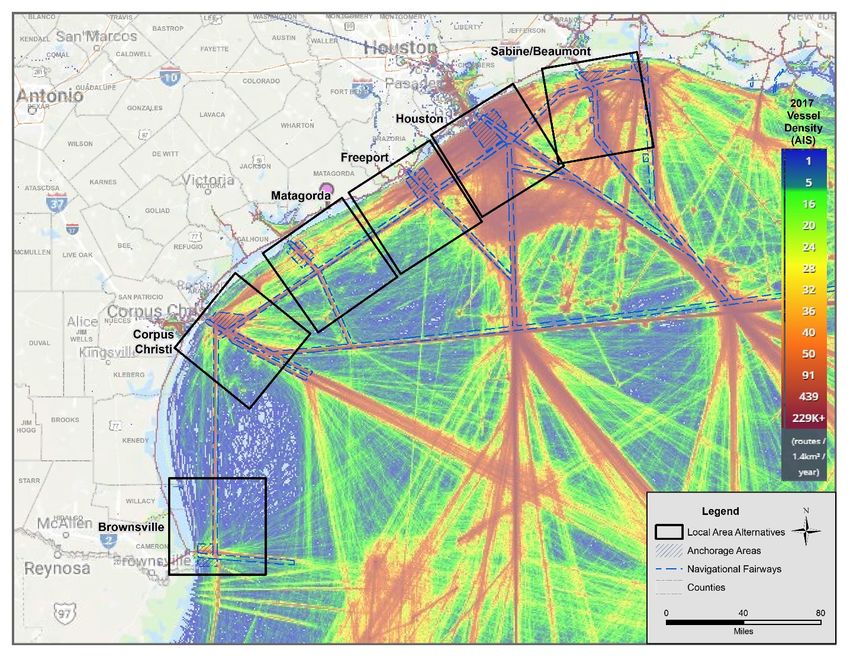
Navigation Criteria 3
The Texas coast has multiple major ports used for waterborne commerce. It is anticipated that the incremental
increases in crude oil production will result in greater exports, and therefore greater vessel traffic and congestion
within existing navigation fairways. As such, consideration was given to the potential for incoming and outgoing
VLCCs to not impact already congested areas and to promote navigational safety. Figure 2-8 provides an overview
of vessel densities within existing navigational fairways along the Texas coast. Based on a review of this information,
the Houston and Sabine/Beaumont areas currently have the highest vessel traffic densities and congestion within
safety fairways.
Figure 2-8: Existing Navigation Fairways and Vessel Densities
Sources: BOEM 2019; Marine Cadastre 2019
2-21 Bluewater SPM ProjectYou can also read