Effect of the BP Deepwater Horizon Oil Spill on Critical Marsh Soil Microbial Functions
←
→
Page content transcription
If your browser does not render page correctly, please read the page content below
Louisiana State University
LSU Digital Commons
LSU Master's Theses                                                                                                              Graduate School

2014

Effect of the BP Deepwater Horizon Oil Spill on
Critical Marsh Soil Microbial Functions
Jason Paul Pietroski
Louisiana State University and Agricultural and Mechanical College

Follow this and additional works at: https://digitalcommons.lsu.edu/gradschool_theses
     Part of the Oceanography and Atmospheric Sciences and Meteorology Commons

Recommended Citation
Pietroski, Jason Paul, "Effect of the BP Deepwater Horizon Oil Spill on Critical Marsh Soil Microbial Functions" (2014). LSU Master's
Theses. 2078.
https://digitalcommons.lsu.edu/gradschool_theses/2078

This Thesis is brought to you for free and open access by the Graduate School at LSU Digital Commons. It has been accepted for inclusion in LSU
Master's Theses by an authorized graduate school editor of LSU Digital Commons. For more information, please contact gradetd@lsu.edu.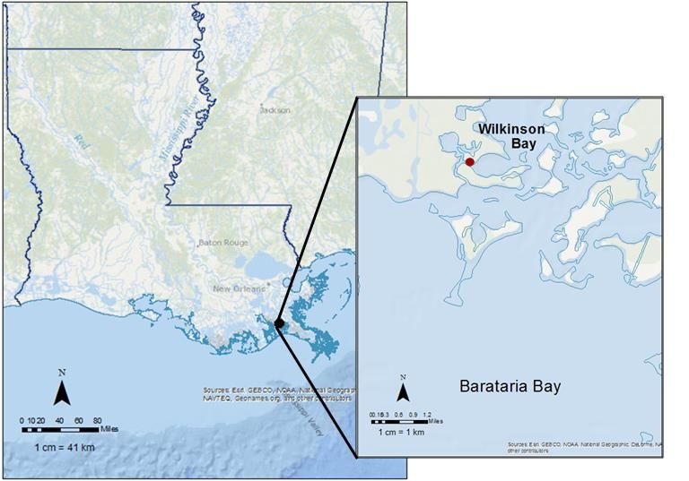
EFFECT OF THE BP DEEPWATER HORIZON OIL SPILL ON
    CRITICAL MARSH SOIL MICROBIAL FUNCTIONS

                        A Thesis

         Submitted to the Graduate Faculty of the
             Louisiana State University and
           Agriculture and Mechanical College
                in partial fulfillment of the
             requirements for the degree of
                    Master of Science

                            in

  The Department of Oceanography and Coastal Sciences

                            by
                    Jason P. Pietroski
          B.S., University of West Florida, 2010
                      August 2014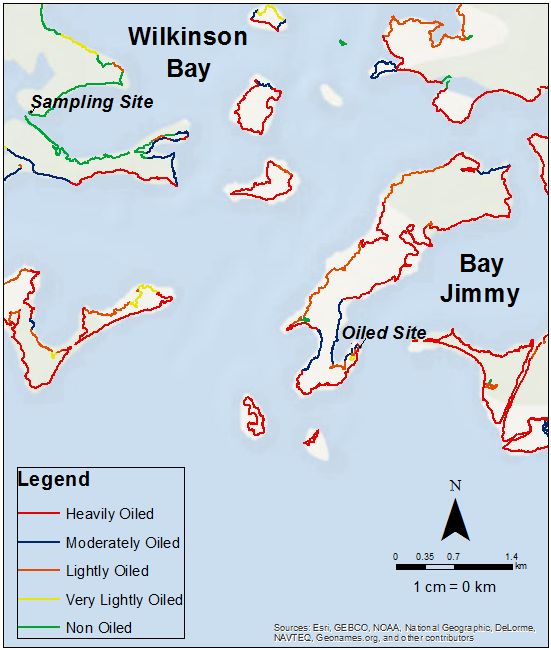
ACKNOWLEDGEMENTS

      I would like to take this opportunity to thank my advisors, Dr. John R. White and

Dr. Ronald DeLaune, for all their support, guidance, insight, and advice throughout my

graduate studies. They have provided me with an immeasurable amount of knowledge

about wetland biogeochemistry. I also owe a great deal of gratitude to my committee

members Dr. Sibel Bargu Ates and Charles Armbruster. I would like to thank all my

committee members for the time and effort they have given to my thesis. I am also

grateful for the help offered by fellow graduate students Nathan Nguyen, Havalend

Steinmuller, Eric Roy, Jacob Berkowitz, and Morgan McKee, as well lab manager and

student worker Anthony Nguyen for assistance in sample preparation and analyses. I

am very grateful for the funding provided to me by the BP Gulf of Mexico Research

Initiative and Louisiana Sea Grant in connection with the Coastal Protection and

Restoration Authority of Louisiana. Finally, I would like to thank my parents,

grandparents, friends, and girlfriend for all their support and encouragement during my

graduate studies. I could not have done this without them.

                                            ii
TABLE OF CONTENTS
ACKNOWLEDGEMENTS ................................................................................................ii
LIST OF TABLES ............................................................................................................ v
LIST OF FIGURES ..........................................................................................................vi
ABSTRACT ................................................................................................................... viii
CHAPTER 1: REVIEW OF LITERATURE ....................................................................... 1
1.1 Crude Oil Spills ...................................................................................................... 1
1.1.1 Crude Oil Spill Effects on Salt Marsh Ecosystems ........................................... 2
1.1.2 Crude Oil Spill Effects on Soil Microbial Populations ....................................... 3
1.1.3 Past Research on the Effects of Crude Oil Spills on Denitrification ................. 5
1.1.4 2010 BP Deepwater Horizon Oil Spill ............................................................. 6
1.2 Chemical Dispersants ............................................................................................ 8
1.2.1 2010 BP Deepwater Horizon Crude Oil Spill Chemical Dispersant Use .......... 9
1.3 Louisiana Coastal Wetland Loss .......................................................................... 10
1.4 Mississippi River Diversions ................................................................................. 10
1.5 Nitrogen Cycle ..................................................................................................... 12
1.5.1 Denitrification ................................................................................................. 12
1.6 Nitrogen Input into the Louisiana Coast ............................................................... 13
1.6.1 Nitrate Removal ............................................................................................. 15
1.6.2 Hypoxia .......................................................................................................... 15
1.7 Summary.............................................................................................................. 16
1.9 Synopsis of Chapters ........................................................................................... 17
CHAPTER 2: THE EFFECT OF FRESH AND WEATHERED SOUTH LOUISIANA
CRUDE OIL ON POTENTIAL DENITRIFICATION RATES OF COASTAL MARSH SOIL
...................................................................................................................................... 18
2.1 Introduction .......................................................................................................... 18
2.2 Materials and Methods ......................................................................................... 22
2.2.1 Study Site ...................................................................................................... 22
2.2.2 Soil Sampling ................................................................................................. 24
2.2.3 Soil Characteristics ........................................................................................ 25
2.2.4 Crude Oil Preparation and Analysis ............................................................... 26
2.2.5 Potential Denitrification .................................................................................. 27
2.2.6 Data Analysis ................................................................................................. 28
2.3 Results & Discussion ........................................................................................... 28
2.3.1 Soil Characterization ...................................................................................... 28
2.3.2 Crude Oil Characterization............................................................................. 30
2.3.3 Fresh and Weathered Crude Oil Effects on Potential Denitrification -
Immediate ............................................................................................................... 32
iii2.3.4 Fresh and Weathered Crude Oil Effects on Potential Denitrification – Longer
term ........................................................................................................................ 33
2.4 Environmental Implications .................................................................................. 35
2.5 Conclusion ........................................................................................................... 37
CHAPTER 3: EFFECT OF DISPERSANT USE FOR OIL SPILL REMEDIATION ON N
CYCLING IN LOUISIANA COASTAL MARSH SOIL ..................................................... 39
3.1 Introduction .......................................................................................................... 39
3.2 Materials and Methods ......................................................................................... 42
3.2.1 Study Site ...................................................................................................... 42
3.2.2 Marsh Soil Sampling ...................................................................................... 44
3.2.3 Soil Characteristics ........................................................................................ 45
3.2.4 Microbial Biomass N (MBN) ........................................................................... 46
3.2.5 Potentially Mineralizable Nitrogen (PMN) ...................................................... 46
3.2.6 Potential Denitrification .................................................................................. 47
3.2.7 Data Analysis ................................................................................................. 48
3.3 Results ................................................................................................................. 48
3.3.1 Soil characterization ...................................................................................... 48
3.3.2 Microbial Biomass Nitrogen ........................................................................... 49
3.3.3 Potentially Mineralizable Nitrogen .................................................................. 50
3.3.4 Potential Denitrification – Immediate Corexit additions .................................. 50
3.3.5 Potential Denitrification Assay – Two week pre-incubation with Corexit ........ 52
3.4 Discussion............................................................................................................ 53
3.5 Conclusion ........................................................................................................... 55
CHAPTER 4: CONCLUSION ........................................................................................ 57
REFERENCES .............................................................................................................. 62
VITA .............................................................................................................................. 70
ivLIST OF TABLES
Table 2.1 Comparison of fresh and weathered crude oil peak areas and concentrations.
...................................................................................................................................... 29
Table 3.1 Wilkinson Bay soil physiochemical properties. Data are means ± 1 standard
error............................................................................................................................... 49
Table 3.2 Microbial biomass N and potentially mineralizable nitrogen production of
Louisiana coastal marsh soil with a range of Corexit additions. Dispersant ratios range
from 1:10 to 1:10,000 (Corexit : wet sediment weight). Data shown are mean values ± 1
standard error (n=4) ...................................................................................................... 50
vLIST OF FIGURES
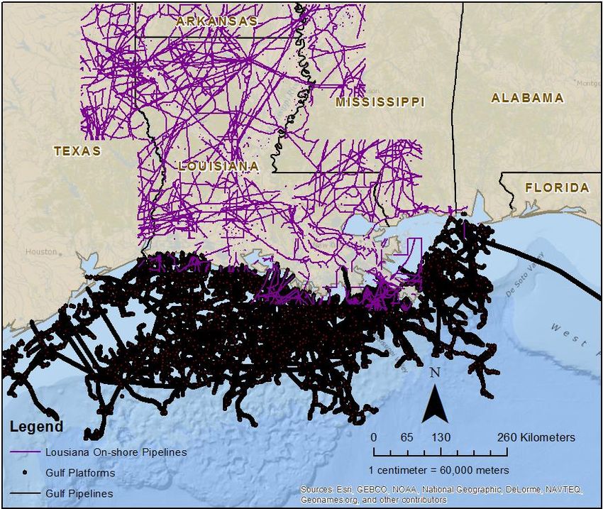
Figure 1.1 Oil production pipelines in the Gulf of Mexico and Louisiana, as well as
offshore Gulf platforms. ................................................................................................... 2
Figure 2.1 Location of the Barataria Bay complex within coastal Louisiana. Inset map
denotes the Wilkinson Bay sampling site, located within Barataria Bay (Arc GIS Base
Map and National Oceanic and Atmospheric Administration, 2013). ............................ 23
Figure 2.2 Distribution of observed maximum oiling of heavily, moderately, lightly, very
lightly, and non-oiled coastal marshes in Wilkinson Bay and Bay Jimmy located within
the Barataria Bay complex compiled by NOAA (Arc GIS Base Map and National
Oceanic and Atmospheric Administration, 2013). The unoiled sampling site and an
observed heavily oiled site are also labeled on the map. .............................................. 24
Figure 2.3 Light and heavy fraction peaks of fresh and weathered crude oil. ................ 31
Figure 2.4 The N2O production potential of Louisiana coastal marsh soil N2O production
with 1:10 oil:wet soil ratio for both weathered and fresh crude oil additions. Data shown
are mean values ± 1 standard error (n = ....................................................................... 32
Figure 2.5 The N2O production as percent of the control (+ 1 standard error) for
weathered crude oil and non-weathered crude oil in 10% oil:wet soil, after initial
exposure. ...................................................................................................................... 33
Figure 2.6 The N2O production as percent of the control (+ 1 standard error) for
weathered crude oil and non-weathered crude oil in 10% oil:wet soil, following 2 week
incubation period. .......................................................................................................... 34
Figure 2.7 Comparison of N2O production as percent of the control (+ 1 standard error)
for weathered crude oil and non-weathered crude oil in 10% oil:wet soil, following
immediate and 2 week incubation period. ..................................................................... 35
Figure 3.1 Location of the Barataria Bay complex within coastal Louisiana. Inset map
denotes the Wilkinson Bay sampling site, located within Barataria Bay (Arc GIS Base
Map and National Oceanic and Atmospheric Administration, 2013). ............................ 43
viFigure 3.2 Distribution of observed maximum oiling of heavily, moderately, lightly, very
lightly, and non-oiled coastal marshes in Wilkinson Bay and Bay Jimmy located within
the Barataria Bay complex compiled by NOAA (Arc GIS Base Map and National
Oceanic and Atmospheric Administration, 2013). The unoiled sampling site and an
observed heavily oiled site are also labeled on the map. .............................................. 44
Figure 3.3 The N2O production potential of Louisiana coastal marsh soil N2O production
with a range of Corexit additions. Dispersant ratios range from 1:10 to 1:10,000 (Corexit
: wet sediment weight). Data shown are mean values ± 1 standard error (n = 4). ........ 51
Figure 3.4 The N2O production as percent of the control (+ 1 standard error) for each
range of Corexit EC9500A additions following immediate exposure. ............................ 52
Figure 3.5 The N2O production as percent of the control (+ 1 standard error) for
concentration range of Corexit EC9500A observed during the DWH spill following
immediate and 2 weeks exposure. (B.D = below detection limit) ................................. 53
Figure 4.1 Effects of the 1:10 additions of oil and Corexit:wet soil weight ratio on
denitrification potential following immediate (Top) and 2 weeks exposure (Bottom). .... 60
viiABSTRACT
On April 20, 2010, the BP Deep-Water Horizon (DWH) offshore oil platform
exploded releasing ~ 795 million L of southern Louisiana (LA) light sweet crude oil into
the Gulf of Mexico. Approximately 7.9 million liters of dispersant, Corexit EC9500A,
were applied for remediation. The effect of BP DWH crude oil and Corexit EC9500A on
two marsh soil microbial processes, (mineralizable nitrogen and denitrification), were
examined in the laboratory. Surface soil samples were collected from an unimpacted
salt marsh site proximal to areas that suffered light to heavily oiling in Barataria Bay, LA.
Additions of oil were at a ratio of 1:10 (crude oil:wet soil), mimicking a heavy oiling
scenario. Carbon and nitrate based compounds were added to investigate the
toxicology of oil and dispersant on denitrifier activity. Potential denitrification rates at the
1:10 weathered crude oil:wet soil ratio were 46 ± 18.4% of the control immediately after
exposure and 62 ± 8.0% of the control following a two-week pre-incubation period.
Potential denitrification rates of soil oiled with fresh crude oil were 51.5 ± 5.3% of the
control after immediate exposure and significantly lower at 10.9 ± 1.1% after two-week
exposure. Potential denitrification rates (acetylene blockage) after immediate
exposure to Corexit:wet soil at ratios of 0:10 (control), 1:10, 1:100, 1:1,000, and
1:10,000 were below detection for the 1:10 treatment while the 1:100 was 7.6 ± 2.7% of
the control and the 1:1,000 was 33 ± 4.3% of the control. The 1:10,000 treatment was
not significantly different from the control. Denitrification rates measured after two-week
pre-incubation were below the detection limit for the 1:10 treatment and the 1:100
treatment was 12 ± 2.6% of the control. Both fresh and weathered crude oil and Corexit
can significantly impact activity of denitrification in the short-term. Corexit also
viiinegatively affected other microbial measures. Microbial biomass nitrogen (N) values
were below detection for the 1:10, 1:100 and 1:1,000 Corexit:wet soil treatments.
Potentially mineralizable N rates were significantly lower for 1:10 and 1:100 Corexit:wet
soil treatments. Future research should include additional oiling levels and extended
exposure periods to determine the recovery of key wetland soil microbial processes.
ixCHAPTER 1: REVIEW OF LITERATURE
1.1 Crude Oil Spills
Crude oil spills are a result of leakage from storage tanks, onshore and offshore
petroleum wells, or accidental releases during transportation (Bonin et al., 1990). While
occasional crude oil spills are an unavoidable part of crude oil extraction, transportation,
and refinement, attempts to mitigate damage are important to control effects on the
aquatic environment. There are over 3,800 fixed structures and 6,500 producing wells
connected to an integrated pipeline network more than 48,000 km in length in the Gulf
of Mexico alone (Figure 1.1; Kaiser, 2009). The average daily production of crude oil
from the federal waters of the Gulf of Mexico is 1.3 million barrels (Kaiser, 2009). The
majority of crude oil is produced from deep-water fields in water depth greater than 305
meters and most of these structures are directly off the Louisiana (LA) coast (Figure 1;
Kaiser, 2009). In LA alone there are approximately 1,500 oil spill notifications to the
National Response Center with an average volume of 1.25 million L yr-1 (Louisiana Oil
Spill Coordinator’s Office). Louisiana oil spills account for 20% of the United States total
amount of spills and volume of oil spilled. Major oil spills in the Gulf of Mexico are rare,
and experts predict that 80% of future Gulf spills will be less than 7949 liters (50
barrels), but if a spill occurs, LA coastal wetlands could receive the brunt of the impact
because majority of oil rigs are located directly off the LA coast (Louisiana Oil Spill
Coordinator’s Office). Most shelf structures in the Gulf of Mexico are primarily gas
producers, with average production rates averaging less than 1.6 million liters (10,000
barrels) of crude oil per day. In the deep water, there are only a few dozen (about 50 or
1so) production facilities, but these structures generally produce 7.9 million liters (50,000
barrels) of crude oil per day (Kaiser, 2009).
Figure 1.1 Oil production pipelines in the Gulf of Mexico and Louisiana, as well as
offshore Gulf platforms.
1.1.1 Crude Oil Spill Effects on Salt Marsh Ecosystems
Brackish and saline marshes are among the environments most likely to be
adversely affected by crude oil spills in LA (Gundlach and Hayes, 1978). Marshes are
among the most productive of all aquatic environments. A vast variety of organisms
and plants live in a delicate balance with the environment. It is spawning ground for a
large number of sport and commercial fish. Detritus from the marsh provides an
important food source for many marine organisms. If oiled, contamination may persist
2with detrimental effects for years (Gundlach and Hayes, 1978). According to Gundlach
and Hayes, (1978), Salt marshes should be designated as the primary environment to
receive protection upon the occurrence of an crude oil spill. Booms or sorbent material
should be applied to prevent crude oil from entering these areas (Gundlach and Hayes,
1978). In extreme cases, such as the Urquiola spill, booms may be utilized to trap oil
within one area to prevent it from spreading to other previously unspoiled shorelines
(Gundlach and Hayes, 1978). Once a salt marsh is severely contaminated, burning or
cutting has been suggested, but only as a last resort (Gundlach and Hayes, 1978).
Some studies indicate that cutting has been used effectively in a number of instances,
though study of plant regeneration in untreated areas was not made (Gundlach and
Hayes, 1978). Flushing of the oiled marsh with water under low pressure is a good
option, since burning or cutting will result in almost total destruction of the resident
benthic community (Gundlach and Hayes, 1978). Often the greatest long-term damage
to the marsh is inflicted by heavy machinery and the large numbers of untrained
personnel brought into the marsh to clean it. In most cases, and particularly where tidal
action and seasonal plant growth is great, physical marine processes should be allowed
to naturally cleanse the marsh (DeLaune and Wright, 2011; Gundlach and Hayes,
1978).
1.1.2 Crude Oil Spill Effects on Soil Microbial Populations
Microbes facilitate many biogeochemical processes in coastal wetlands and
estuaries, including carbon sequestration (DeLaune and Wright, 2011), water quality
improvements and serve as the essential component that regulates the base of the
detrital food chain (Dosskey et al., 2010). Heterotrophic microbes are present in the
3environment and some species are also important for the breakdown of hydrocarbons
released as a consequence of natural crude oil seeps, as well as anthropogenic
hydrocarbon releases into the marine environment (Hamdan and Fulmer, 2011;
Mahmoudi et al., 2013). Microbial degradation of crude oil is a particularly important
process for the recovery of wetland systems because most components of crude oil are
biodegradable (DeLaune and Wright, 2011). Previous studies on spilled crude oil in
coastal wetlands, including the LA Gulf coast, have focused on crude oil effects on
wetland plants and benthic organisms (Delaune et al., 1979; Delaune et al., 1984;
Patterson et al., 1993). Little effort has been directed at understanding the microbial
response to oiling, especially in southern LA coastal marshes (DeLaune and Wright,
2011; Hamdan and Fulmer, 2011). Some mesocosm studies in Texas have focused on
the microbial response to crude oil additions (Wright et al., 1996; Wright et al., 1997).
Other studies have documented changes in microbial populations in wetlands in
response to crude oil exposure (Hood et al., 1975; Oppenheich et al., 1971). These
responses showed general increases in total microbial populations and increases in the
ratio of hydrocarbon degraders to total heterotrophs (DeLaune and Wright, 2011).
Biodegradation of crude oil components in wetlands have been demonstrated in
greenhouse studies (Delaune et al., 1990), but the rates of degradation are strongly
dependent on nutrient availability and other environmental conditions. The processes
affecting spilled crude oil in open waters are dominated by volatilization, photolysis, and
dispersion (Prince, 1997), while the processes in wetland soils and sediments are
dominated by transport and biodegradation.
4There have also been studies conducted on the effects of crude oil and chemical
additives on mixed microbial populations in fresh marsh soils (Nyman, 1999). Soil
respiration and reduction potential were compared for 6 months among microcosms
containing freshwater marsh soils using Arabian and LA crude oil. None of the
treatments slowed microbial activity. Instead, LA crude oil with fertilizer additives
accelerated activity. This shows that there may be a difference in the effects of crude
oil on freshwater marsh soil microbes compared to those of saltwater marshes.
1.1.3 Past Research on the Effects of Crude Oil Spills on Denitrification
Past studies of the effects of crude oil on denitrification in marine salt marsh
sediments include the study conducted by Bonin et al., 1990, which looked at the
denitrification activity in different types of sediment from the Mediterranean coast of
France before and after a massive contamination (30-100 g kg-1 sediment) of
hydrocarbons. They used a closed system in order to maintain anoxic conditions and to
control substrates and gaseous product concentrations. All analytical assays to
determine the physical, chemical, and bacterial characteristics of the sediment were
performed before and after the enrichment with petroleum (Bonin et al., 1990). The
crude oil used was Arabian light crude. Within the 6 locations analyzed, the sediment
characteristics ranged from 95% fine sandy sediment to 95% muddy clay sediment.
This study only collected the top two centimeters of several cores of sediment and
homogenized them. The concentrations of crude oil to sediment ranged from 5 to 10%.
This study concluded that denitrification decreases 4 to 7 weeks in total inhibition
between the crude oil contaminated samples and non-crude oil contaminated samples
(Bonin et al., 1990).
5Other studies conducted on denitrification potential found similar results of
decreased rates with crude oil contamination (Griffiths et al., 1982; Haines et al. 1981).
Haines et al., (1981) found that in surface sediment samples collected from the Alaskan
continental shelf (Beaufort Sea), crude oil inhibited the natural denitrification, but there
was no effect on potential denitrification measurements with added nitrate. Griffiths et
al., (1982), performed a similar study collecting sediments from the Kasitsna Bay on the
Alaskan shelf showing that both natural and potential denitrification was negatively
affected by exposure to crude oil. The experiment conducted is not completely
comparable to the reports of these previous studies as ours was only conducted for
short time periods as compared to Haines et al., (1981), and Griffiths et al., (1982),
whose studies lasted up to 18 months. The author did not determine the concentrations
of crude oil actually mixed into the sediment. It has been concluded by past
experiments that the percentage of crude oil insertion is dependent on the nature of the
sediment. Although the exact mechanism involved in the denitrification inhibition of
crude oil is not known, it was suggested that the perturbation of natural environmental
conditions by petroleum could explain changes and decrease of the denitrification
(Griffiths et al., 1982).
1.1.4 2010 BP Deepwater Horizon Oil Spill
The BP Deepwater Horizon (DWH) spill released a U.S. Government estimated
4.9 million barrels of crude oil in to the Gulf of Mexico over an 87-day period, from April
20 to July 15, 2010 (Michel et al., 2013). The BP DWH spill oiled several Gulf Coast
ecosystems including LA barrier islands and marshes (DeLaune and Wright, 2011).
The degree of impact on coastal wetlands and their recovery is variable depending on
6the amount of oiling, type of oil, weathering state of the oil, climate, ecosystem type,
environmental conditions, and scope of response. During the spill there were conflicting
reports about the extent of shoreline that was impacted by the BP DWH Oil Spill.
Shoreline assessment team’s documented stranded crude oil along the shoreline of the
Gulf of Mexico concluding that 1,773 km of shoreline was oiled (Michel, et al., 2013).
Studies conducted from municipal Pensacola Beach, FL, revealed weathered crude oil
petroleum hydrocarbon (C8 to C40) concentrations ranged from 3.1 to 4,500 mg kg-1 in
beach sands (Kostka et al., 2011). The documented range of oiling varied between
locations. Of the shoreline impacted, beaches comprised 50.8%, marshes 44.9%, and
other shoreline types 4.3%. Shoreline cleanup activities were authorized on 660km, or
73.3%, of oiled beaches and up to 71 km, or 8.9%, of oiled marshes and associated
habitats (Michel et al., 2013). One year after the spill began, crude oil remained on 847
km; two years later, crude oil remained on 687 km, though much lesser degrees of
crude oil (Michel et al., 2013). Crude oil is still present even four years after the spill in
heavily impacted areas. Shorelines characterized as heavily oiled went from
approximately 360 km, to 22.4 km after one year, and to 6.4 km two years later (Michel
et al., 2013). Understanding the short and long term response of Gulf wetland
ecosystems to the spill is critical. Natural recovery of crude oil impacted ecosystems
involves a complex series of processes including crude oil volatilization, dispersion, and
biodegradation, all of which serve to remove crude oil, given enough time and proper
environmental conditions (DeLaune and Wright, 2011). Studies have shown that the
abundance of hydrocarbon degrading bacteria was 10 times greater in oiled beach
sands and were confirmed as oil degrading microorganisms (Kostka et al., 2011).
71.2 Chemical Dispersants
Dispersant solutions are a combination of hydrocarbon based solvents and
surfactants, with the purpose of lowering the interfacial tension between crude oil and
water to prevent formation of large, surface oil slicks (Kujawinski et al., 2011).
Dispersant use during oil spills has both prevented and enhanced environmental
damages in the past (Etkin, 1998). The dispersant effectiveness depends on the type
of oil, the amount of oil spilled, proximity of the oil to the shore and sensitive
ecosystems, the weather and sea conditions at the time of the spill and during
response, the type of chemical dispersant available at the time of the spill, and the
potential efficiency of other cleanup methodologies available (Etkin, 1998).
The first recorded use of chemical dispersants on an oil spill was for the 1966
tanker oil spill off the coast of Germany, which had favorable results and minimal
environmental impact (Lewis and Aurand, 1997). The successful use of dispersants
during this scenario encouraged use for future oil spill events. Of the 408 oil spills in the
Oil Spill Intelligence Report-International Oil Spill Database, 90% of major spills during
1966-1969 used chemical dispersants as the main clean up method (Etkin, 1998).
The completely positive view of chemical dispersant use disappeared after the
1967 Torrey Canyon oil spill where 420,000 gallons of various chemical dispersants
were applied directly on the shoreline to treat the spill of 38.2 million gallons of crude oil
(Etkin, 1998; Linden et al., 1987). The ratio of chemical dispersant:oil was extremely
high compared to present day applications and should not have been applied directly to
the shoreline (Etkin, 1998). The dispersants had devastating effects on the coast that
became apparent in later environmental evaluations (Smith, 1968). The first generation
8of chemical dispersants used highly toxic aromatic hydrocarbons as the carrier solvent
and was later discovered to result in environmental damages that far exceeded the
damages from crude oil alone (Etkin, 1998). Much of the negative views towards
chemical dispersants stem from the high toxicity of the formulations and improper
application techniques used in response to the Torrey Canyon spill. Dispersant usage
dropped significantly during the 1970’s, and is currently used in only 52.2% of all oil
spills as a cleanup response (Etkin, 1998). The environmental impact concerns
regarding dispersants led to newer, safer formulas which diminished the content of
aromatic hydrocarbons as the carrier solvent, replacing it with surfactants.
1.2.1 2010 BP Deepwater Horizon Crude Oil Spill Chemical Dispersant Use
One of the strategies used during the 2010 BP Deepwater Horizon (DWH) oil
spill to mitigate the environmental impacts and safety concerns of the oil was to spray
the dispersant Corexit EC9500A (Hamdan and Fulmer, 2011). Corexit EC9500A is a
blend of oxyalkylate polymers, organic sulfonic acid salt, substituted fatty ester, glycol
ether, and aliphatic hydrocarbons (Utley, 1998). There is also the potential for reaction
byproducts of Corexit EC9500A to form that are not listed in the dispersant ingredients
(Place et al., 2010). A total of ~ 7.9 million liters of the dispersant, Corexit EC9500A,
was used during the BP DWH Oil Spill between May 15th and July 12th 2010 (Kujawinski
et al., 2011). The applications were split with ~ 5.3 million liters applied to the surface
and 2.9 million liters dispensed at the wellhead (Kujawinski et al., 2011). The
dispersant was applied by sprayer jet at the wellhead, and aerially by small vessels at
the surface (Kujawinski et al., 2011). The rationale for surfactant application at the
surface was to break up large surface oil slicks, while the use at the wellhead, located
91522 m underwater, was to prevent the crude oil from reaching the surface and
becoming a slick (Paris et al., 2012).
1.3 Louisiana Coastal Wetland Loss
Wetland loss along the LA coastal zone has long been recognized as one of the
state’s most pressing environmental problems (Morton et al., 2006). Of the numerous
factors contributing to this loss, perhaps the leveeing of the Mississippi River for flood
control has had the most far-reaching impact, blocking the river’s historic spring
overflows and thus impeding the rush of marsh-supporting fresh water, nutrients and
sediment to the coastal zone (Day et al., 2000).
Of the areas within the LA coast, the Barataria Basin has one of the greatest
wetland loss rates at 16.9 km2 yr-1 (FitzGerald et al., 2007) and is an area in need of
sedimentation. The Barataria bay complex is an interdistributary estuary bordered by
the Mississippi River and by Bayou Lafourche. The estuary system is shallow and
turbid with an average depth of about 2 meters (Happ, et al., 1977).
1.4 Mississippi River Diversions
Mississippi River diversions are the use of new channels and/or structures to
divert sediment and nutrient rich water from the river into adjacent basins and are the
main restoration technique for deltaic sedimentation (Peyronnin et al., 2013). An added
benefit to diversions is the ability of coastal marsh and wetlands to remove excess
nutrients. In particular the nitrate load can be removed by burial, assimilation into plant
or algal biomass, returned to the atmosphere by denitrification, or reduction to ammonia
(Reddy and DeLaune, 2008).
10The Davis Pond diversion was the first diversion built to combat erosion rates in
the Barataria Basin by imitating historic spring floods, providing a controlled flow of fresh
water, sediment, and nutrients from the Mississippi River to the estuary (U.S. Army
Corps of Engineers). Located on the west bank of St. Charles Parish and completed in
December 2000, the diversion is made up of four iron-gated 14 foot by 14 foot box
culverts built into the Mississippi River levee. An inflow channel 535 feet long by 85 feet
wide directs river water into the structure, while an outflow channel more than 11,000
feet long by 120 feet wide connects the structure to the ponding area and ultimately
diverts fresh water into the estuary (U.S. ACE). The total project area is comprised of
10,084 acres, including the 9,300-acre ponding area. The Davis Pond diversion is able
to divert up to 10,650 cubic feet per second (cfs) of fresh water and was opened to
maximum capacity during the BP oil spill to divert oil away from the coastal marsh (U.S.
ACE).
The Louisiana Coastal Protection and Restoration Authority have contracted two
new sediment diversions to be built into both the mid and lower Barataria Basin (CPRA,
2012). The Mid and Lower Barataria diversion max flow rates are 250,000 cfs and
50,000 cfs. The Mid-Barataria Diversion is much larger than the Lower Barataria
Diversion and both are part of the first implementation period of the Master Plan taking
place from 2012-2031 (CPRA, 2012). Both projects will cost a combined total of
approximately 478 million dollars (Peyronnin et al., 2013). These diversions are
significantly larger than the Davis Pond Diversion.
111.5 Nitrogen Cycle
Nitrogen is an important nutrient in biologically active processes and is often the
limiting nutrient in coastal systems for primary production. Plants and algae utilize
either ammonium or nitrate as the source of nitrogen for growth. The nitrogen cycle is
dynamically important in biological processes because of its five naturally occurring
oxidation states, ranging from +5 to -3 (Reddy and DeLaune, 2008). Dinitrogen (N2)
gas completes several conversions from inorganic to organic and back to inorganic
nitrogen with the release of N2 gas into the atmosphere. Nitrogen fixation occurs only
in few bacterial species where elemental nitrogen (N2) is converted to ammonium
(NH4+) (Reddy and DeLaune, 2008). This conversion makes N2 gas available for use by
assimilation into plant biomass. Mineralization is the breakdown of organic nitrogen to
inorganic nitrogen by the conversion of NH4+ to nitrate (NO3-), with the midway
conversion into nitrite (NO2-), to break down organic matter (Reddy and DeLaune,
2008). Denitrification is the conversion of NO3- to NO2- to N2O and finally N2 gas, where
it is released back into the atmosphere. Ammonium is assimilated directly, while nitrate
is reduced to ammonium in plant cells before use. Nitrate is reduced to ammonia
through the nitrate reductase enzyme. Ammonia is hydrolyzed to ammonium and
incorporated into plants and algae as amino acids and proteins (Reddy and DeLaune,
2008). The nitrogen cycle in wetlands includes inputs, storage, and outputs.
1.5.1 Denitrification
Denitrification is mediated by denitrifying microbes and occurs only in anaerobic
conditions, where nitrate is used as the alternative electron donor in place of oxygen to
oxidize organic matter (Lane, et al., 2003; Reddy and DeLaune, 2008). The pathway in
12which this occurs is NO3- to NO2- to N2O and finally to N2 gas. Denitrification is an
important component of the nitrogen cycle by removing excess nitrogen from the
system and releasing N2 gas back into the atmosphere. The rate of denitrification is
limited by the nitrate concentration and presence of organic carbon (Dodla et al., 2008).
Denitrification is a primary controlling factor in primary productivity by removing excess
nitrate that would otherwise be available for assimilation by plant and algal growth.
Nitrous Oxide (N2O) is an obligate intermediate in the process of reducing NO3- to N2
gas by facultative microbes (Blackmer and Bremner, 1978). A ratio of N2O to N2 gas
indicates that about 94% of N2O is reduced to N2 during denitrification (Blackmer and
Bremner, 1978).
1.6 Nitrogen Input into the Louisiana Coast
Inputs of nitrogen are derived from both natural and anthropogenic sources.
Natural inputs include biologically fixed nitrogen, precipitation, and particulate matter,
which are abundant in the environment (Reddy and DeLaune, 2008). Natural sources
of nitrogen are usually low because the environment is at equilibrium between
production and use of nitrogen (Antweiler et al., 1995). Ammonia is a readily available
form of nitrogen for the use in biological processes of plant and algae species. The
Haber-Bosch industrial process has increased the production of ammonia for use in the
agricultural fields (Roy and White, 2012). The Haber-Bosch process has increased the
bioavailable nitrogen pool by up to 50% and has changed the global nitrogen balance.
Over the past 80 years, nitrate concentration in the Mississippi River has steadily
increased. Nitrate concentrations before 1940 were between 0.2 to 0.4 mg N L -1. Since
1940, the nitrate concentration has increased to between 1.0 and 2 mg L -1 (Lane et al.,
131999; Antweiler et al., 1995). It is estimated that seventy five percent of nitrate entering
the Gulf of Mexico from the Mississippi River since 1940 is from anthropogenic sources
(Antweiler at al., 1995). Nitrate concentrations are high during the late winter, spring,
and early summer, while nitrate concentrations are lower during the mid to late summer,
fall, and early winter (Antweiler et al., 1995). Anthropogenic nitrate inputs are both point
source and non-point source to coastal wetlands. Point source inputs of nitrate include
waste-water discharge and industrial wastes (Antweiler et al., 1995). Non point sources
of nitrate are primarily from urban area runoff (Reddy and DeLaune, 2008), agricultural
fields (Antweiler et al., 1995; Reddy and DeLaune, 2008), and animal wastes (Antweiler
et al., 1995). Nitrogen storage in wetlands is a combination of plant and microbial
biomass, soil organic nitrogen, pore water nitrogen, and exchangeable nitrogen.
Outputs are the loss of nitrogen from storage in the wetland and are lost from the
system from outflow of water, loss of dissolved gasses, and loss of plant biomass
(Reddy and DeLaune, 2008).
The Mississippi River watershed basin is ~3.1 million km2 and has an average
flow rate at the mouth of the river of 600,000 cubic feet per second (National Park
Service). Of those nutrients, nitrogen has significantly negative effects on the
Mississippi delta and Gulf Coast, producing extensive seasonal hypoxia events
(Rabalais et al., 2002). Though an overabundance of nitrogen can cause hypoxia
events, nitrogen availability is often the limiting factor for crude oil degradation in coastal
marshes and nitrogen additions may facilitate crude oil biodegradation in the case of an
crude oil spill (DeLaune and Wright, 2011). The availability of nitrogen for crude oil
biodegradation depends on many processes such as dinitrogen fixation, denitrification,
14organic matter decomposition, plant uptake and release, and tidal action (DeLaune and
Wright, 2011).
Nitrate is the predominant form of nitrogen present in the Mississippi River,
therefore Mississippi River water diverted into the Barataria Basin is high in nitrate.
Ammonia runoff from agricultural fields within the drainage basin is oxidized to nitrate
under aerobic conditions in the Mississippi River before reaching diversion sites such as
the Barataria Basin. As water from southern LA diversions flows through the estuary,
nitrate concentrations decrease (Lane et al., 2003). Possible reductions in nitrate are
from denitrification; dilution by exchange with the Gulf of Mexico; assimilation by plants,
algae, or bacteria; and burial (Lane et al., 2003).
1.6.1 Nitrate Removal
Nitrate removal depends on several factors. Residence time (Reddy and
DeLaune, 2008) and loading rate (Lane et al., 2003) are the main factors in the
effectiveness of nitrate removal in wetlands. Residence time is related to discharge
rate, where maximum removal rate occurs at low flow from the Davis Pond diversion. A
study on residence time in the Davis Pond Diversion found high discharge rates into the
Barataria Bay marshes, resulting in nitrate reaching the Gulf of Mexico (DeLaune et al.,
2005). Also, low nitrate loading results in maximum removal efficiency. The soil water
interface is important for nitrate removal to occur. Removal of nitrate occurs by
assimilation into plant or algal biomass, denitrification, or burial (Lane et al., 2003).
1.6.2 Hypoxia
Hypoxia in the Gulf of Mexico occurs when dissolved oxygen concentration
declines below 2 mg O2 L-1 and is a common estuarine phenomenon (Turner et al.,
152008). Louisiana coastal marshes experience excess nitrate in coastal waters,
promoting large phytoplankton blooms, leading to annual coastal hypoxia and anoxia
(Turner et al., 2008). The Northern Gulf of Mexico near the mouth of the Mississippi
River has the second largest zone of coastal hypoxia in the world (Rabalais et al.,
2002). The combination of high freshwater discharge, wind mixing, regional circulation,
and summer warming conditions are controlling factors for the strength of stratification
that goes through a seasonal cycle and is necessary for hypoxic conditions. The
formation of the large hypoxic mass is also a result of enhanced primary production
from the physical structure of the water column and high nutrient loads (Rabalais et al,
2002).
1.7 Summary
Oil spills affecting the LA coast is an occurrence that will continue in the future
due to the large amount of oil extraction, transport, and refinement that takes place in
and around the LA coast. The location of a spill plays a big role in controlling the
degree of weathering which takes place from the time the oil is released until it comes in
contact with the coast. The effects of weathered oil compared the non-weathered
(fresh) oil to LA coastal marsh is unknown. Though many studies have been conducted
on the effects of oil and dispersants on coastal plant and animals, very few studies have
been conducted on the effects of marsh soil microbial processes. Denitrification and
nitrogen mineralization are two important processes within the nitrogen cycle which
have important ecosystem function roles, including water quality and coastal marsh
primary productivity. The findings of effects on microbial processes are compared to
the effects on microbial presence through biomass measurements as well.
16The research presented in this thesis seeks to compare the effects of weathered
crude oil to that of fresh crude oil on denitrification rates, as well as effects following
immediate exposure compared to 2 week pre exposure to see if effects vary over time.
Studies focus on the effects of oil compared to that of dispersants on denitrification
rates to determine if using dispersants is more harmful than the crude oil in the case of
this important microbial process. The author hypothesizes that biogeochemical
functions are affected by dispersant and oil additions.
1.9 Synopsis of Chapters
In Chapter 2, the impact of fresh and weathered crude oil are compared to
determine if an oil spill that occurs on or near shore is more detrimental than an oil spill
off shore. The reason being, on shore oil spills allow the crude oil to go through
weathering processes, through the atmospheric interaction that changes the crude oils
chemical and physical properties, before coming into contact with the coast.
Additionally, explore if longer term (2 week) exposure, for both fresh and weathered
crude oil, have a greater impact on denitrification rates than immediate exposure.
Having established the impacts of fresh and weathered crude oil on denitrification
in Chapter 2, Chapter 3 determines the effects of dispersant additions on denitrification
rates, nitrogen mineralization rates, and soil microbial biomass. Determining the impact
of both crude oil and dispersant on the important biogeochemical processes, which
regulate water quality functions and productivity functions. The implications of all
research chapters are discussed in Chapter 4.
17CHAPTER 2: THE EFFECT OF FRESH AND WEATHERED SOUTH LOUISIANA
CRUDE OIL ON POTENTIAL DENITRIFICATION RATES OF COASTAL MARSH
SOIL
2.1 Introduction
Crude oil platforms and associated infrastructure are located within the coastal zone
all around the globe. Crude oil spills can be the result of leakage from storage tanks,
distressed vessels, onshore and offshore petroleum wells, or accidental releases during
transportation. While infrequent crude oil spills are likely an unavoidable consequence
of crude oil extraction, transportation, and refinement, it is critical to understand the
extent of damage to ecosystem functions, once exposed. In the Gulf of Mexico, there
are over 3,800 fixed structures and 6,500 producing wells connected to an integrated
pipeline network more than 48,000 km in length (Kaiser 2009). The average daily
production of crude oil from the federal waters of the Gulf of Mexico is 1.3 million barrels
(Kaiser 2009). The majority of crude oil is produced from deepwater fields in water
depth greater than 305 meters and the majority of these structures are directly off the
Louisiana (LA) coast (Kaiser 2009). In LA alone, there are approximately 1,500 oil spill
notifications to the National Response Center each year with an annual mean volume of
1.25 million L yr-1 (LOSCO). Oil spills in LA account for 20% of the United States total
amount of spills and volume of oil spilled. Major oil spills in the Gulf of Mexico are rare,
but if a spill occurs, LA’s coastal wetlands can receive the brunt of the impact. The
location of an crude oil spill (on-shore vs off-shore) can determine the characteristics of
the crude oil that impacts the coastal system. The amount of time the crude oil is in
contact with the atmosphere can change both its physical and chemical composition
through an initial fractionation process. Fractionation, which is a major part of the
18weathering process, results in the loss of the lighter, more volatile, smaller carbon chain
fractions to the atmosphere (Wang and Fingas, 1995). The most recent and notable
example of an offshore crude oil spill affecting the U.S. with primarily weathered crude
oil was the 2010 BP Deepwater Horizon (DWH) oil spill which occurred 66 km off the LA
coast. This spill released ~ 795 million liters of crude oil over the 87 day event (McNutt
et al., 2012; Paris et al., 2012). Once the crude oil was released from the wellhead, 1.5
km below the surface, the crude oil rose through the water column and began impacting
shorelines after about a week (Paris et al. 2012). The south LA light sweet crude oil
came ashore in the states of Louisiana, Alabama, Mississippi, Texas, and Florida driven
by wind, waves and currents (Levy and Gopalakrishman, 2010). However, due to
differences in travel time, the crude oil that reached the coastline exhibited variable
levels of fractionation.
There are also other causes of major crude oil spills in the LA coastal zone. For
example, storm surges and waves associated with Hurricanes Katrina and Rita in 2005
led to the destruction of 46 crude oil platforms, while disabling 20 others. In addition,
over 50 oil spills were reported within the near shore environments due to damage of
storage tanks and leaks from disabled vessels during the storms (Pine, 2006) which
impacted the coastline with fresh (non-weathered) crude oil.
The characteristics of the spilled crude oil and the extent of the weathering process
are potentially important in determining the extent of the impacts to coastal wetland
ecosystems, including important biogeochemical processes. Highly weathered crude oil
is dense, forming tar-ball masses and has a tendency to sink, affecting benthic
communities. Fresh crude oil has components of both heavy fractions that sink and
19lighter fractions which more effectively cover the plants and surface marsh soils due to
high buoyancy related to hydrophobicity. The hydrocarbons in crude oil have variable
size ranges of carbon chains. Lighter fraction compounds are with 16 carbon chains or
less, and the heavy fraction comprised of >16 carbon chains. The significance of the
number of carbons in the chain is that smaller chains are most susceptible to
volatilization. In addition, the lighter fractions are not only the more volatile but tend to
also be the more toxic and include decane, undecane, and napthalene (Van Hamme et
al., 2003).
The effects of spilled crude oil on benthic communities, invertebrates, and marsh
vegetation have been widely documented (Delaune et al., 1979; Elmgren et al., 1983;
Gesteira and Dauvin 2000; Hester and Mendelssohn 2000). Research conducted
during the 1978 Amoco Cadiz oil spill and the 1992 Aegean Sea oil spill concluded that
soft-bottom benthic communities were negatively impacted through disappearance of
some species and reduction in the numbers of others (Gesteira and Dauvin 2000) while
evidence from the 1977 Tsesis oil spill in in the Baltic sea found reductions of up to 95%
of benthic amphipods within 16 days of the spill (Elmgren et al., 1983). Various field
and greenhouse studies have been conducted to evaluate crude oil effects on selected
Gulf Coast salt marsh plants (DeLaune et al., 2003; Delaune et al., 1979). The extent of
oiling tends to determine salt marsh vegetation responses, which show different levels
of sensitivity to oiling. Spartina patens was the most sensitive to crude oil exposure with
complete die off within 1 month, while Panicum hemitomon and Spartina alterniflora had
only minimal decreases in aboveground biomass. Biomass of Sagittaria lancifolia, and
20Typha latifolia were not affected by surface soil oiling as long as the leaves were not
coated (DeLaune et al., 2003).
While there has been significant research on the effect of crude oil spills on various
coastal ecosystem components, few studies have been conducted on crude oil impacts
on the wetland microbial communities or microbial-driven ecosystem functions
(DeLaune et al., 2011; Hamdan and Fulmer 2011). Microbes facilitate many
biogeochemical processes in coastal wetlands and estuaries, including carbon
sequestration (DeLaune and White, 2012), water quality improvements (Wang et al.,
2006) and serve as the essential component that regulates the base of the detrital food
chain through enzymatic degradation of soil organic matter (Vidon et al., 2010; DeLaune
and White, 2012). Some species of heterotrophic microbes also play an active role in
the breakdown of hydrocarbons, which can be released as a consequence of natural
crude oil seeps as well as anthropogenic hydrocarbon releases into the coastal and
marine environments (Hamdan and Fulmer, 2011; Mahmoudi et al., 2013). Denitrifying
bacteria, a facultative functional microbial group, reduces nitrate through their
respiratory pathway by converting nitrate (NO3-) to nitrous oxide (N2O) and nitrogen gas
(Tiedje et al., 1982). Therefore, denitrification is an important ecosystem function of
coastal wetlands as it is an important N removal process in coastal marshes (Gardner
and White, 2010; VanZomeren et al., 2012). This ecosystem function is particularly
important in coastal LA as excess NO3- in coastal waters can promote significant
springtime phytoplankton blooms followed by large expanses of coastal hypoxia and
anoxia (Turner et al., 2008). Therefore, the goal of this study was to determine the
effects of both immediate and longer term exposure of fresh and weathered crude oil on
21potential denitrification rates in coastal LA marsh soil. The extent of exposure to crude
oil is investigated to understand if there are associated effects to denitrification rates
with continued crude oil exposure over time since crude oil following an oil spill can
persist in an soil profile for many years. The effects of fresh and weathered oil are
compared to determine if a spill that occurs on or near shore contaminating a coast with
fresh crude oil has the same effect as an spill occurring offshore contamination the
coast with weathered crude oil.
2.2 Materials and Methods
2.2.1 Study Site
The Barataria bay complex is an interdistributary estuary bordered by the
Mississippi River and by Bayou Lafourche, containing large tracts of marshes along the
coast dominated by Spartina alterniflora and interspersed with small bays. The estuary
system is shallow and turbid with an average depth of about 2 meters (Happ et al.,
1977). Several marshes in the Barataria Basin received light to heavy oiling when
onshore winds coupled with tidal action pushed the BP DWH crude oil into the estuary
(Lin and Mendelssohn 2012).
Marsh soil samples were collected on April 8, 2013 from a Spartina alterniflora
marsh site within Wilkinson Bay in the Barataria Basin, LA (Figure 2.1; N29° 27,976
W89° 56,072). The Emergency Response Management Agency (ERMA) Deepwater
Gulf Response mapping efforts documented this section of the Wilkinson Bay was
deemed non-oiled from the BP DWH oil spill. The bay is located approximately 6.4 km
northwest of Bay Jimmy, which was heavily oiled by the spill and contains identical plant
22communities (Figure 2.2). This specific site was chosen since it was deemed non-oiled
by NOAA, allowing exact concentrations of dispersant and oil additions to be made in
an laboratory setting. Although no significant BP DWH crude oil is currently washing up
on shorelines of the Gulf of Mexico, the author noted, while sampling 3 years after the
spill, that crude oil is buried in some coastal marshes in Barataria Basin with oil layers a
few cm below the surface. Because Barataria Basin has one of the highest wetland
loss rates on the LA coast at 16.9 km2 yr-1 (FitzGerald et al., 2007), the author observed
that buried crude oil has been exhumed along the erosional edges of the marsh and re-
deposited on the surface anew, suggesting a chronic oiling process.
Figure 2.1 Location of the Barataria Bay complex within coastal Louisiana. Inset map
denotes the Wilkinson Bay sampling site, located within Barataria Bay (Arc GIS Base
Map and National Oceanic and Atmospheric Administration, 2013).
23You can also read