Science and Politics in China's Official Water System: the Management of the Qiantang River (1927-1949)* - Brill
←
→
Page content transcription
If your browser does not render page correctly, please read the page content below
EASTM 51-52 (2020): 51-89

    Science and Politics in China’s Official Water
   System: the Management of the Qiantang River
                     (1927-1949)*

                    Li Haijing and Sally K. Church

[Li Haijing is an associate professor at the Water Culture Institute at Zhejiang
University of Water Resources and Electric Power, Hangzhou. Having received
her Ph.D. from the University of Science and Technology of China (USTC) in
2017, she focuses on the history and culture of water conservancy, especially
concerning the Qiantang River between 1927 and 2011. She was a visiting scholar
at the Needham Research Institute in 2017-2018, supported by the Li Foundation
of New York. Her most recent article, co-authored with Wu Huiyi and Han
Cengui, published in Ziran bianzhengfa yanjiu 自然辯證法研究 36.1 (2020), is
on Joseph Needham’s investigation of the Qiantang River during his visit to China
in 1964. Contact: lavalhj@126.com]
[Sally K. Church is an Affiliated Researcher in the Faculty of Asian and Middle
Eastern Studies, Cambridge, and a Research Associate at the university’s Centre of
Development Studies and at the Needham Research Institute. With research
interests in diplomacy and transport on both the maritime and overland Silk Roads,
she has most recently focused on the size of Zheng He’s ships, shipbuilding in
Nanjing’s Longjiang Shipyard, and the diplomatic missions of Chen Cheng to
Herat in the Ming period. Contact: skc1000@cam.ac.uk]
                                      ***

    *
      Acknowledgements: The authors would like to express their gratitude to Prof.
Shi Yunli 石云里, Prof. Chen Kunlong 陈坤龙, Prof. Christopher Cullen, Prof.
Catherine Jami, and the two reviewers, for their advice and guidance. This research
has received funding from the following grants: “2020 nian Zhejiang sheng shehui
guihua keti: Minguo shiqi Qiantang jiang zhili shi yanjiu,” 2020 年浙江省社科规划
课 题 : 民 国 时 期 钱 塘 江 治 理 史 研 究 (Code: 20NDJC211YB); “2019 niandu
shuiwenhua yanjiu keti: Qiantang jiang liuyu guhaitang yiji xianzhuang diaocha
jiqi wenhua yichan jiazhi yanjiu,” 2019 年度水文化研究课题:钱塘江流域古海塘遗
迹 现 状 调 查 及 其 文 化 遗 产 价 值 研 究 (Code: SWH201902); “2017 nian guojia
waizhuanju gaoduan xiangmu: Huanghe wenming de haiwai chuanbo yu silu
yanxian wenming gongrong yanjiu,” 2017 年国家外专局高端项目:黄河文明的海外
传播与丝路沿线文明共融研究 (Code: GDW20174100155).

                                        51

                                                        Downloaded from Brill.com08/02/2021 04:35:10AM
                                                                                         via free access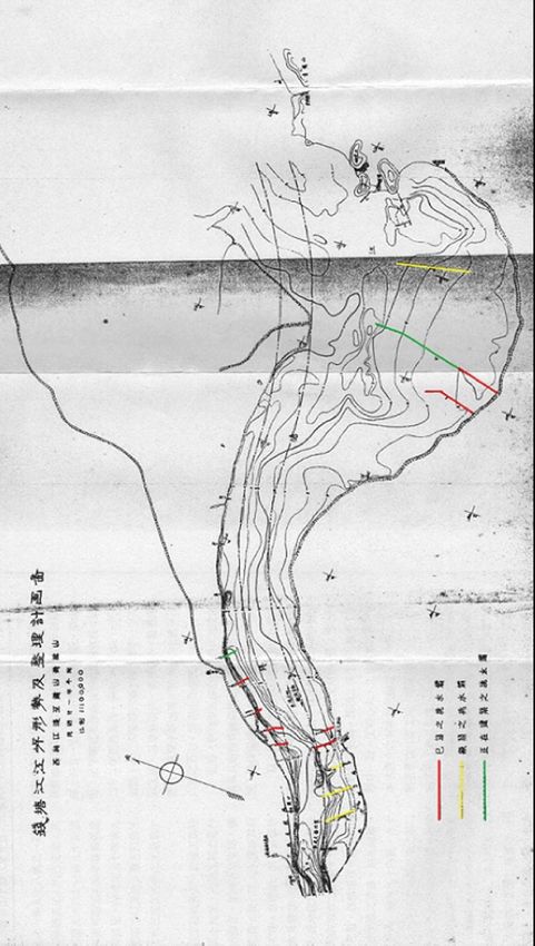
52                                                           EASTM 51-52 (2020)

Abstract: Western water science and technology were introduced to
upgrade China’s traditional water management methods and strategies
during the Nanjing decade (1927-1937) under the Nationalist government.
The engineering efforts expended to control the Qiantang River were
typical examples of such initiatives. The primary strategy to protect areas
surrounding the river from the destruction caused by the Qiantang bore
was for centuries one of “passive defence”, with the construction of defen-
sive seawalls featuring prominently among the methods used. However,
the Qiantang tide consistently broke through these defences, and caused
devastation. After 1927, while the old defensive methods were not
completely discarded, more active strategies of river regulation were
introduced, under the combined influence of Western methods, materials
and expertise, and Western-trained Chinese engineers who stepped
forward to tackle the problem. These activities were interrupted during the
war years (1937-1945), but resumed again after the war. During the 22
years from 1927 to 1949, in four discrete stages, different technological
solutions were devised, priorities identified, guidelines developed and
strategies attempted, with each stage championed by a different engineer
in charge. Gradually these efforts formed into what can be called the
Qiantang River Project, a concerted effort to apply the knowledge of
Western science and technology to change previous “passive defence”
methods to “active governance” strategies for river regulation that com-
bined both prevention and control. Efforts at each stage were influenced by
factional struggles at the top of the government, and also affected by
Western competition for Chinese interests. These developments were all
part of the complex interaction of science and politics that took place in the
management of the Qiantang River between 1927 and 1949.

                                Introduction

Since 1840, the introduction of Western water conservancy science and
technology has had a profound impact on Chinese water conservancy
construction methods. Western hydraulic experts and specialised Chinese
engineers educated in Western water science began to dominate hydraulic
engineering in China. This paper, which builds on a previous paper
published in 2017 in Chinese,1 describes one example of this phenomenon:
the engineering efforts carried out in the Republican period to control the

    1
      Li and Shi (2017). This research was funded by the Li Foundation of New York
and the Needham Research Institute, as well as the China Association for Science
and Technology’s “Data Collection Project on the Academic Growth of Older
Scientists” (Item number: CJGC2016-GKD09).

                                                        Downloaded from Brill.com08/02/2021 04:35:10AM
                                                                                         via free access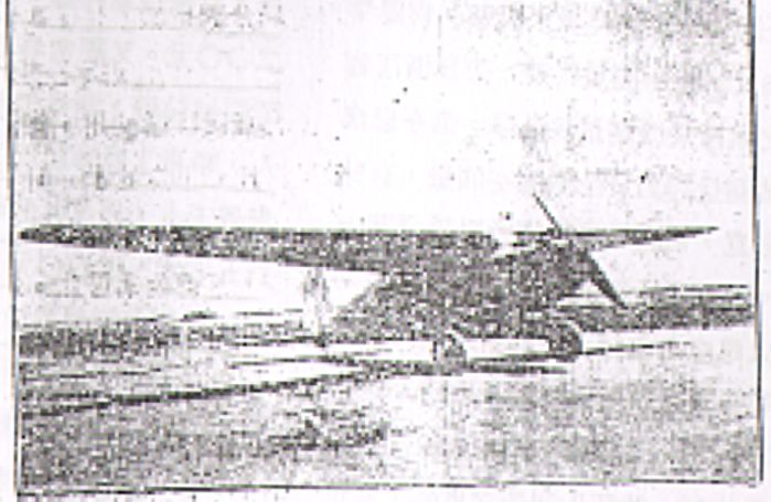
LI AND CHURCH: THE MANAGEMENT OF THE QIANTANG RIVER (1927-1949)                          53

Qiantang 錢塘 River. These efforts took place in four stages, each directed
by a different engineer who attempted to apply Western scientific knowl-
edge and expertise to a single problem: controlling the Qiantang River to
prevent flooding and the resulting damage to the surrounding areas. In
each case, the engineering work centred mainly on the Qiantang estuary.2
    Because these efforts all had the same goal, and were similar in other
aspects, we argue that they led to the gradual formation of what might be
called the Qiantang River Project. All four stages of this project shared a
number of common features and methodologies: in addition to facing
certain international tensions and conflicts between science and politics,
they can be seen as the gradual evolution of a single project to apply
Western technology, knowledge and expertise to the control of the
Qiantang River, even though the precise measures recommended in each
stage, and the individual experiences of the engineers in question differed
in certain ways. Because the proposed measures were cumulative, with
each subsequent stage for the most part incorporating and building on the
suggestions made in the previous stages, we argue that they can best be
analysed as stages in a single project.
    This paper takes a slightly different approach from the 2017 Chinese
paper. It traces the evolution and development of the Qiantang River
Project through four key stages during the period from 1927 to 1949. The
first three stages took place between 1927 and 1937. Then work on it had to
be halted because of the Anti-Japanese War (1937-1945). It resumed after
1945 and work on the fourth stage took place between 1945 and 1949. Each
stage was led by a different Western-educated specialist in hydraulic
engineering, who worked together with the Chinese government to reduce
the negative impact of the Qiantang bore on the coastal and inland areas of
Zhejiang province around Hangzhou. The measures taken were based on
scientific analyses of the problem and knowledge of existing solutions, but
they were not purely a matter of science and technology. Because this was
such a turbulent time, political issues often entered into the equation. In
each case the interaction between science and politics helped to shape the
direction that the project took, often presenting obstacles to progress.
However, the obstacles were ultimately overcome. The project evolved
gradually into one that was successful in creating a new strategy and set of
guidelines for the control of the Qiantang River, and formed the basis for
measures that are still in use today.
    The Qiantang estuary is located in the coastal area where the Qiantang
River meets the East China Sea. One of the most prominent features of its

   2
      The Qiantang estuary lies south of the Changjiang (Yangzi) River estuary and
north of the hilly region of Zhejiang from Wenyan 聞堰 to Ganpu 澉浦. See Han et
al. (2002).

                                                        Downloaded from Brill.com08/02/2021 04:35:10AM
                                                                                         via free access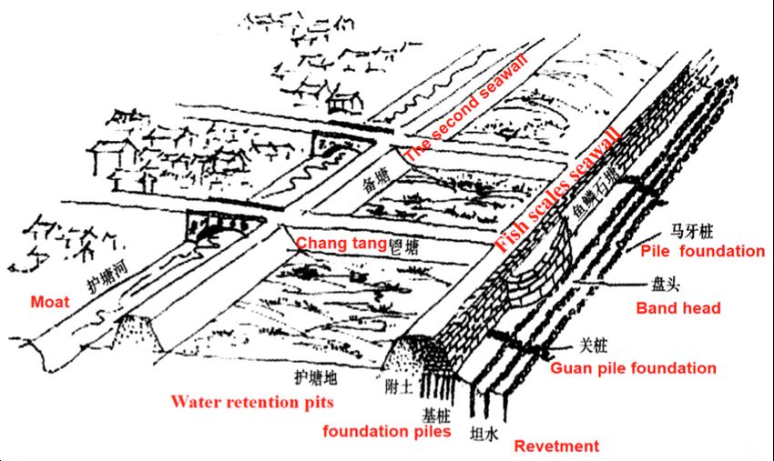
54                                                                EASTM 51-52 (2020)

natural landscape is the Qiantang tidal bore. The Qiantang bore is not
unique—there are about 450 estuaries and bays in the world with tidal
bores.3 According to the height of the tide and its speed of travel, some
scholars have ranked the Qiantang bore first among the top ten in the
world. The others are the bores of the Amazon River (Brazil), the Seine
River (France), the Petitcodiac River (Canada), the Severn River (UK), the
Gironde River (France), the Shubenacadie River (Canada), the Turnagain
Arm (USA), the Salmon River (Canada) and the Hoogly River (India).4
Among these, the Qiantang tide was described by Commander W. Usborne
Moore as “the strangest, rarest, and most wonderful sight in the world”.5
The exceptional height and speed of the bore are the result of the
interaction of the tide-generating force of the earth-moon-sun system with
the horn-shaped estuary and large sandbars at the mouth of the river.6
    Apart from being a fascinating phenomenon of nature, the Qiantang
River and its surrounding region has a distinctive economic status in China.7
To the north is the Hang-Jia-Hu 杭嘉湖 plain, and to the south the Xiao-
Shao 蕭紹 plain. According to economic and social statistical data from
2005, the land area of these two plains combined is equal to 19,200 sq. km,
constituting 19% of the arable land of Zhejiang province. The total popu-
lation of these two plains is 15.2 million, accounting for 35% of Zhejiang
province. The GDP of the two plains accounts for 51% of the province’s
GDP according to early twenty-first century data, 8 and the Qiantang
estuary has been one of the most economically developed areas not only in
Zhejiang but in China as a whole.9 On the other hand, the Qiantang tide
has caused many natural disasters and flooding. From 619 to 1948,

     3
       Chanson (2011).
     4
       Sentinelles Petitcodiac Riverkeeper (2001); Pan (2007).
     5
       Moore (1888).
     6
       Chen et al. (1964); Harris (1988); Dalrymple et al. (1990); Kunte et al. (2005); Yu
et al. (2012).
     7
       The Hang-Jia-Hu plain is named after three cities: Hangzhou 杭州, Jiaxing
嘉興 and Huzhou 湖州. It is located in the northern part of Zhejiang province, south
of the Taihu river basin (Taihu liuyu 太湖流域), which is the largest plain in
Zhejiang province. Its geographic scope includes the area south of the Taihu, the
north of Qiantang River and Hangzhou bay, and east of Tianmu 天目 mountain. Its
administrative scope includes Jiaxing, most of Huzhou 湖州, and northeastern
Hangzhou; it is part of the Yangtze River plain. The Xiao-Shao plain (Xiao-Shao
pingyuan 蕭紹平原) is named after Xiaoshan 蕭山 and Shaoxing, also in Zhejiang
province. It consists of the districts of Xiaoshan, Binjiang 濱江 and the city of
Shaoxing.
     8
       Zhejiang sheng tongji ju tongji nianjian (2006).
     9
       Zhejiang province is the main source of China’s national financial income. Its
GDP ranked fourth in China in 2005.

                                                             Downloaded from Brill.com08/02/2021 04:35:10AM
                                                                                              via free access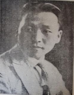
LI AND CHURCH: THE MANAGEMENT OF THE QIANTANG RIVER (1927-1949)                               55

disasters of this kind have been recorded approximately 183 times, twelve
of which took place in the Republican period.10 For example, in June 1932,
the area between Qingtai Gate 清泰門 and Qibao 七堡 in Hangzhou lost
more than 200 hectares of sandy land. 11 Therefore, successive local
governments have paid special attention to the Qiantang River, which
became a keen focus of attention during the Qing and Republican periods.

Perspectives on the Qiangtang Tide in China and the West
Reports of the unusual phenomenon of the Qiantang bore have been made
for centuries. Writing in the first century BCE, Sima Qian 司馬遷 relates in
his Shiji 史記 (Records of the Grand Historian of China) that when the First
Emperor of China, Qin Shihuang 秦始皇, travelled to this region on an
Imperial Progress in the third century BCE, he did not dare to cross the
Qiantang River because of the ferocious tidal bore.12 Local officials also
began to look for solutions early on. Liu Daozhen’s 劉道真 Qiantang ji
錢塘記 of the Eastern Jin (Xijin 西晉, 265-316) period contains the earliest
record of the construction of a seawall on the Qiantang River. According to
this text, a person named Hua Xin 華信 constructed a seawall of earth and
stones to control the tide.13 Disasters on the Qiantang River are mentioned
in Tang, Song, Ming and Qing sources. They often posed threats to the
Taihu plain, one of the rice-bowls of China and it has been a priority for the
both central and local governments to avert these disasters throughout
Chinese history. Before the twentieth century, the Chinese government
pursued an essentially defensive policy, preventing the flooding of arable
land and devastation of granaries by building defensive seawalls along the
northern and southern banks of the river. Limited by the state of its
technological development at that time, China could not completely
eliminate the tidal bore. The result was that many sturdy seawalls were
built, now called the “Great Wall of the Sea” (hanhai changcheng 捍海長城).
    When Westerners first saw the bore, on the other hand, they tended to
see it as a natural wonder, a unique natural phenomenon. 14 The first
Western report of the bore was by Commander W. Usborne Moore of the
Royal Navy. When his fleet arrived at Hangzhou bay in September 1888, it
was unable to enter the city by water because of the tidal conditions. His

   10
       Qiantang jiang zhi bianzuan weiyuanhui (1998), pp. 132-133.
   11
       Qiantang jiang zhi bianzuan weiyuanhui (1998), p. 135.
    12
       Shiji, juan 6 “Qin Shihuang benji,” p. 260.
    13
       Wang (1984), pp. 1252-1254.
    14
       Nowadays, it is a government requirement that if immersed structures are to
be built on the Qiantang River, the impact of the project on the tide bore must first
be studied. Zhejiang Institute of Hydraulics and Estuary specialises in evaluating
the influence of such projects. If the project has a significant impact on the tidal bore,
it will be disallowed, or a design change may be imposed.

                                                             Downloaded from Brill.com08/02/2021 04:35:10AM
                                                                                              via free access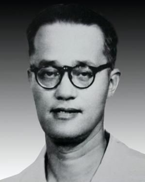
56                                                           EASTM 51-52 (2020)

discovery of the Qiantang bore motivated him to carry out a detailed inves-
tigation involving extensive research on it, which he described in detail,
including its height, time of arrival and many other details. This report is
the first modern hydrological survey we have concerning the Qiantang
bore.15 In 1923, A. C. Moule published a survey of the knowledge of and
legends surrounding the Qiantang tide as recorded in Chinese historical
materials.16 Joseph Needham examined Moule’s research and made an in-
depth study of ancient Chinese perceptions of the tidal bore, comparing
Chinese and Western understandings. 17 In 1964, Needham visited the
Qiantang River and investigated the Qiantang seawall personally. His
account of the history of the construction and development of the engi-
neering on the Qiantang seawall was based on these investigations.18
   Many other twentieth-century scholars from the fields of natural and
social sciences have studied the tidal bore and the ancient seawall of the
Qiantang River. Several Chinese scholars have written monographs on the
history of water conservancy in China, all of which dedicate a section or
even a chapter to the Qiantang tide.19 Chinese scholars have also studied
the construction and historical evolution of the Qiantang seawall.20 Mark
Elvin and Su Ninghu have published their extensive research on the
morphological changes and dynamics of estuaries, and the problem of the
sediment from the sea in the Hangzhou bay.21 Two hydrological engineers,
Tao Cunhuan 陶存焕 and Zhou Chaosheng 周潮生, both of whom had
worked on the Qiantang River, made an in-depth study of the ancient
seawall, and discussed the introduction of Western technology and the
development of basic scientific research on the problems posed by the
Qiantang River during the Republican period.22 These studies have focused
on the subject from a scientific and technological point of view. However,
they have not included the political dimension in their discussion: the
problems faced by Chinese engineers who tried to implement practical
measures to solve the key problems involved in taming the Qiantang River.
Pierre-Étienne Will’s study of civil engineers in early twentieth century

     15
      Moore (1888), pp. 39-46.
     16
      Moule (1923).
   17
      Needham and Wang (1959), p. 494.
   18
      See Li, Wu and Han (2020); Needham, Wang and Liu (1971), p. 323.
   19
      Zheng (1939), p. 2; Zheng (1987), pp. 188-220; Shen and Zhang (1979); Yao
(1987), p. 279; Zhou (2002), pp. 381-385.
   20
      Zhu (1955); Wang (1988), p. 5; Zhang (1990), p. 5; Chen (2000); Tao and Zhou
(2001); Jiang and Tao (2002).
   21
      Elvin and Su (1998).
   22
      Tao and Zhou (1992), pp. 1005-1010.

                                                        Downloaded from Brill.com08/02/2021 04:35:10AM
                                                                                         via free access
LI AND CHURCH: THE MANAGEMENT OF THE QIANTANG RIVER (1927-1949) 57
China, while mentioning at least one of the key figures involved, does not
specifically address the Qiantang bore.23
This article therefore includes the political dimension (both national
and international) in its study of the evolution and development of the
Qiantang River Project. The primary focus here is on the four stages of
development that occurred in the Republican period under the Nationalist
government based in Nanjing. The period from 1927 to 1937 was one of
relative peace and stability when the focus of the development was on
infrastructural development and when Western science and technology
was available for application to practical problems. The first three stages
took place during this period. There was then an interruption from 1937
to 1945 because of the Anti-Japanese War, but work was resumed after the
war and the fourth stage took place in 1946-1949. Below we will describe
the approach taken in each of these four stages of development, and the
personalities involved, as well as the difficulties faced and overcome, with
special attention being paid to the interactions between science and politics
during these different stages.
Technical Aspects of Qiantang River Defences
The Qiantang bore poses two major risks to the surrounding countryside.
The first danger is the bore itself and the floods it causes, which are often
powerful enough to put most seawalls at risk of collapse. When the seawall
collapses, seawater flows into the inner river and affects the Lake Tai basin
(Taihu liuyu 太湖流域), resulting in crop failures, displacement of the
population, and losses in government tax revenue.
For centuries, seawalls have been built on the banks of the river to
protect the plains and act as defences against the tidal bore. Many different
types of seawall were constructed from the Tang to the Qing periods, in-
cluding earthen walls (tutang 土塘), walls made of wooden stakes (chaitang
柴塘), walls of mixed earth and stone (tu shi hunhe tang 土石混合塘),
bamboo-basket and wooden-box stone gabions (zhulong mugui shi tang 竹籠
木櫃石塘), stone walls (shi tang 石塘), and so-called ‘fish-scale’ stone walls
(yulin shitang 魚鱗石塘).24 Throughout this long period, the technology of
seawall construction was constantly being improved to meet the needs of
daily production and living conditions. New, stronger stone seawalls were
23
Will (2019). We are grateful to one of the reviewers for bringing a number of
important studies to our attention. Unfortunately, language barriers have
prevented us from using the article by Thomas Harnisch (1999) published in
German. We hope that readers able to consult this article will find it useful.
24
Fish-scale stone seawalls were built on the beach, supported by wooden posts
(muzhuang 木樁), with a large strip of stone as the body. The stone is attached to a
butterfly rivet (hudie tie 蝴蝶鐵), with an adhesive made of glutinous rice lime
(nuomi shihui 糯米石灰), which formed the completed gravity-type stone seawall.
Downloaded from Brill.com08/02/2021 04:35:10AM
via free access58 EASTM 51-52 (2020)
created by Huang Guangsheng 黃光昇 25 (1506-1586) in the Jiajing 嘉靖
period (1522-1566) of the Ming dynasty, but the government did not have
enough funds at that time to construct an entire new stone seawall on the
north bank of Qiantang River.
The construction of defensive walls against the bore is part of what we
are calling a “passive approach” to the Qiantang River. This method
continued to be used until the Ming period. With the strengthening of the
imperial power in the Qing period, particularly in the eighteenth century,
the Qianlong emperor (r. 1735-1796) adopted more aggressive defensive
measures than had been used in Ming dynasty, calling it the strategy of
“Don’t give an inch; work once, rest forever” (cunbu burang, yilao yongyi
寸步不讓,一勞永逸) strategy, replacing the policy of “Retreat step by step,
don’t fight for land against the sea” (bubu tuirang, bu yu hai zhengdi 步步退
讓,不與海爭地) of the Ming period.26 Specific measures adopted during
the Qing included the construction of a permanent stone seawall and the
formation of a sophisticated protection system on the north bank: see
Figure 1. There was also another change: the growing importance of the
seawall led to its construction being considered a national rather than local
responsibility, with funding provided centrally rather than locally.
Moreover, the aim changed from protecting the Grand Canal to protecting
the entire Hang-Jia-Hu plain 杭嘉湖平原. This trend has continued into the
modern period.
The second danger posed by the Qiantang River consists of the changes
that occur in the course of the river. Because the channel (jiangdao 江道)
of the Qiantang River is very wide and the water is very shallow, many
disasters have come about when the water has changed course. Historically,
the Qiantang estuary consists of three channels: the south gate channel
(Nan da men 南大門) near the south bank, the middle-small gate channel
(Zhong xiao men 中小門), and the north gate channel (Bei da men 北大門)
near the north bank (shown in Figure 2, p. 60). The mainstream of the river
often switches from one of these gates to another. The switch occurs at
unpredictable intervals of between three and twenty years; sometimes
25 Huang Guangsheng was a statesman, strategist, jurist, hydrologist and
historian, who advocated education. He was appointed Assistant Surveillance
Commissioner (anchashi qianshi 按 察 使 僉 事 ) in 1541, and presided over the
construction of water conservancy projects. He created the technique of building
“five vertical and five longitudinal” fish-scale stone seawalls, which reached the
peak of seawall construction technology at the time. Mingdai zhiguan Zhong-Ying
cidian (2017).
26
When seawalls were destroyed by the tide, the Ming and previous dynasties
constructed new seawalls on river beaches further from the river. The Qing
employed different measures and built even stronger seawalls where previous ones
had collapsed in order to protect against flood.
Downloaded from Brill.com08/02/2021 04:35:10AM
via free accessLI AND CHURCH: THE MANAGEMENT OF THE QIANTANG RIVER (1927-1949) 59
every three years, sometimes every five years, sometimes every ten years,
and so on. There are records of these changes in local gazetteers (difang zhi
地方志), memorials (zou zhe 奏折) and official reports (guan bao 官報).
When the river channel is stabilised at the north gate, a bar of silt or
sand forms on the south bank. Because the overall trend of the mainstream
remains uncertain, the local people develop and use the marshland to plant
all kinds of crops, build salt fields, and even create settlements. Then, when
the main channel suddenly changes again, the sedimentary land on the
south bank starts to collapse.27
Since 1927, with the introduction of Western water science and technol-
ogy, Chinese hydraulic experts were no longer satisfied with the defensive
approach to the control of the Qiantang bore, e.g. by building seawalls.
Instead, they hoped to solve the fundamental problem by proactively
controlling the channel. This new approach was a radical change from the
past, from passive defence to proactive control. However, they did not
abandon defensive measures entirely and the new policy is called “preven-
tion and control” in this paper. Between 1927 and 1949, the implementation
of the “prevention and control” policy on the Qiantang River proceeded in
four stages, led by four engineers. In chronological order, these were Xu
Kai 須愷, Ludwig Brandl, Zhang Zili 張自立 and Zhang Shunong 張書農.
The following four sections will introduce their work and their proposals
for solving the problem of controlling the Qiantang River.
Figure 1. The overall protection system under the Qing dynasty
SOURCE: Lin (2010), p. 82.
27
“Zhejiang shuizai ji” (1926).
Downloaded from Brill.com08/02/2021 04:35:10AM
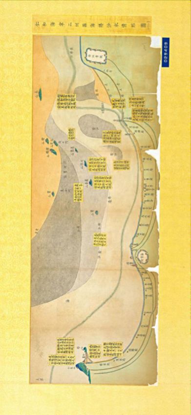
via free accessFigure 2. Sand-Water Situation Map from Renhe (present-day Hangzhou) to 60
Haining in the Qianlong period
SOURCE: Taibei gugong bowuyuan 台北故宫博物院 (Taipei Palace Museum).
NOTE: The Qianlong Emperor required local officials to submit sand-water maps on a regular basis and to
report in memorials on the changes in sand and water conditions along the Qiantang River. The darker
colours in the illustration indicate long-standing, or “old sand” (lao sha 老沙), and the light shades indicate
newly formed “new sand” (xin sha 新沙). From the changes to the sand along the beaches, it is possible to
understand the path taken by the mainstream of the river when it changes course.
EASTM 51-52 (2020)
via free access
Downloaded from Brill.com08/02/2021 04:35:10AMLI AND CHURCH: THE MANAGEMENT OF THE QIANTANG RIVER (1927-1949) 61
1. Xu Kai’s Proposal (1927-1928)
Figure 3. Xu Kai
SOURCE: Baidu Baike, URL: https://baike.baidu.com/pic/须恺/4210598/
0/9a1151c2767d4b0ae5dd3bc4?fr=lemma&ct=single#aid=0&pic=9a1151c27
67d4b0ae5dd3bc4, accessed on 10 May 2019.
Xu Kai was born in Wuxi 無錫 in Jiangsu province. In 1915, he enrolled in
the first class of the Hehai Engineering School (Hehai gongcheng
zhuanmen xuexiao 河 海 工 程 專 門 學 校 ) in Nanjing. 28 In 1920, he was
recommended by his school and the Shunzhi Conservancy Commission
(Shunzhi shuili weiyuan hui 順直水利委員會) in Tianjin to work in the
Turlock Irrigation District in California. He studied in the Department of
Irrigation, University of California, San Francisco in 1922. While in the
United States, he conducted field trips to investigate various water
conservancy construction projects in Illinois, New York and Chicago. He
returned to China in 1924 with a master’s degree and then engaged in the
planning and designing of the Jinghui canal (Jinghui qu 涇惠渠) in the
28
Xu Kai is mentioned in Will (2019), pp. 97-100. Also known as Hohai College
of Engineering, the Hehai Engineering School was founded in 1915 by the
educationalist and industrialist Zhang Jian 張 謇 (1853-1926). It was the first
institution of learning in China to specialise in water conservancy, and pioneered
education in water management.
Downloaded from Brill.com08/02/2021 04:35:10AM
via free access62 EASTM 51-52 (2020)
Shaanxi Bureau of Water Conservancy (Shaanxi shuili ju 陝西水利局),29 as
assistant to Li Yizhi 李儀祉 (1882-1938).30
The year 1927, when Chiang Kai-shek 蔣介石 came to power, marked
the end of the warlord period. China was now unified and began rebuild-
ing its infrastructure. Because some of the seawall had collapsed, the tidal
bore threatened the north-south plains. To address this problem, the
Zhejiang government reconstituted the Qiantang River Seawall Engineering
Bureau (Qiantang jianghai tang gongcheng ju 錢 塘 江 海 塘 工 程 局 ) 31 to
manage both the northern and southern seawalls.32 We see the formation
of this Bureau as the launch of what we have called the Qiantang River
Project. The first step taken by the Bureau was to make regulations ex-
plicitly requiring that its various sections be headed by engineers, and that
hydraulic experts be invited to take charge of the engineering work, thus
forming the so-called “expert governance system”.33 In 1927, Xu Kai was
appointed as an engineer in the Hanghai 杭海 department of the Qiantang
River Engineering Bureau. One of his major achievements was to submit a
proposal to the government in November of that year, entitled “An Opinion
on the Governance of the Qiantang River” (Zhili Qiantang jiang yijian shu
治理錢塘江意見書). In it he suggested the following courses of action:34
1. Develop the upstream region comprehensively; and fully utilise
hydroelectric resources.
2. Control the channel to prevent the collapse of the south bank. Build spur
dikes (dingba 丁壩) to reduce the impact of the tide and limit channel shifts.
3. Perform basic scientific research, such as carrying out hydrological,
topographic and other surveys.
4. Implement long-term plans for the construction of new seawalls, harbour,
and channels.
5. Ensure unified management of all projects so that the construction of the
seawall, the regulation of the river and any measurements are carried out
by the same organisation.
This proposal received support from the politician He Yingqin 何應欽
(1890-1987), chairman of Zhejiang provincial government (Zhejiang sheng
29
‘Zhongguo xiandai shuili renwu zhi’ bianshen lingdao xiaozu, bianzuan
bangongshi, bianji bu (1994), p. 328.
30
Li Yizhi presided over the construction of the Jinghui canal in Shaanxi
province. He was a famous hydrologist and educator from Puxian 蒲縣, Shaanxi,
and became an expert in hydrology in 1930.
31
“Choushe Qiantangjiang gongchengju an” (1927).
32
The seawalls on the northern and southern sides of the Qiantang River have
historically been managed by two different institutions. This reorganisation has
unified the management of the seawalls on both sides of the river.
33
Zhejiang sheng zhengfu weiyuanhui (1928).
34
Xu Kai (1927).
Downloaded from Brill.com08/02/2021 04:35:10AM
via free accessLI AND CHURCH: THE MANAGEMENT OF THE QIANTANG RIVER (1927-1949) 63
zhuxi 浙江省主席).35 The Zhejiang government issued a decree “demand-
ing that the engineers carry out research to find a permanent strategy and
approach to eliminate disasters on the Qiantang River, by replacing the
temporary scheme for repairing and building seawalls”. 36 This decree
makes several things clear. First, the government did not have a permanent,
long-term strategy before this time. Second, politicians were interested in
developing a long-term strategy and the government listened to the advice
of the engineers and followed their advice to some extent. Finally, the
government recognised the prevention strategy of seawall construction and
repair as a temporary measure that it wanted to supplement it with other,
more scientific measures of controlling the river. This was the beginning
of a new era. At Xu Kai’s instigation, China’s approach to the Qiantang
River changed from “prevention” to “prevention and control”. This stage is
therefore the first step in the formation of the Qiantang River Project.
Unfortunately, Xu Kai was unable to carry out his plans for the
Qiantang River. Here, politics came into play. When He Yingqin left
Zhejiang to return to the military on 7 November 1928, the leadership
of the Zhejiang Construction Department and the Qiantang River Seawall
Engineering Bureau changed. That same year, Xu Kai left Zhejiang for
Nanjing, where he was appointed professor at the Department of Civil
Engineering, Fourth Zhongshan College, Nanjing National University
(Nanjing guoli disi Zhongshan daxue gongxueyuan 南京國立第四中山大學
工學院).
2. Ludwig Brandl’s Proposal (1928-1931)
In August 1928, the Qiantang River Seawall Engineering Bureau was
reorganised and expanded to become the Zhejiang Water Conservancy
Bureau (Zhejiang sheng shuili ju 浙江省水利局), which was responsible for
managing water conservancy in Zhejiang province. Its activities included
the engineering works on the Qiantang River, and the reconstruction and
repair of the seawall. The Bureau issued a new administrative provision:
technological experts were appointed to the posts of director and heads of
the various engineering departments, including the Hangzhou-Haining
Seawall Department (Hanghai duan haitang gongcheng chu 杭海段海塘工
程處), the Yanguan-Pinghu Seawall Department (Yan-Ping duan haitang
35
He Yingqin studied in Japan in his early years and attended the Japanese
Military Academy. He joined the “Alliance Association” (Tongmeng hui 同盟會)
founded by Sun Yat-sen 孫中山 while studying in Japan.
36
Zhejiang sheng zhengfu (1927), p. 40.
Downloaded from Brill.com08/02/2021 04:35:10AM
via free access64 EASTM 51-52 (2020)
gongcheng chu 鹽平段海塘工程處), and the Xiaoshan-Shaoxing Seawall
Department (Xiao-Shao duan haitang gongcheng chu 蕭紹段海塘工程處).37
Like its predecessor, the newly established Zhejiang Water Conservancy
Bureau had the support of provincial political institutions. In this case it
was affiliated with the Construction Department of Zhejiang province
(Zhejiang sheng jianshe ting 浙江省建設廳). The provincial government
appointed Dai Enji 戴恩基38 (b. 1894) as director, and Ludwig Brandl as
chief engineer of the Zhejiang Water Conservancy Bureau.
Born in Vienna in 1874, Brandl acquired a diploma in engineering at the
Vienna Technical University. He began working for the Danube Regulatory
Commission in 1898, and in 1926 was appointed director of the electricity
plant of Vienna’s municipality. His work experience made him a good
candidate to become chief engineer of the Zhejiang Water Conservancy
Bureau. His appointment to this post seems to have come about through
his acquaintance with Zhu Jiahua 朱家驊, who went to Germany to study
engineering in 1914-1917.39 Zhu Jiahua was a protégé of Zhang Jingjiang
張靜江 (1877-1950),40 who had subsidised Zhu’s studies in Germany. Zhang
Jingjiang was a high-level politician in the Nationalist government who
37
The Hang-Hai seawall department was responsible for managing the seawall
from Hangzhou to Haining; the Yan-Ping seawall department was responsible for
managing the seawall from Haiyan to Pinghu; and the Xiao-Shao seawall
department was responsible for managing the seawall from Xiaoshan to Shaoxing.
38
Dai Enji (sometimes written Tai En-chi) was born in 1894 and studied
engineering in Germany together with Zhu Jiahua (see below). After returning to
China, he taught at Sun Yat-sen University. In 1928, he served as director of the
Qiantang River Engineering Bureau and of Zhejiang Province Water Conservancy
Bureau. He was general manager of China National Aviation Corporation from
1932 to 1937.
39
Zhu Jiahua was born in Wuxing 吳興 county, Huzhou 湖州, Zhejiang. In 1908,
he met Zhang Jingjiang, who provided funds for him to study mining engineering
at the University of Mines in Berlin, enrolling in October 1914. When he returned to
China, he became a professor at Peking University. He received Beiyang 北洋
government funding to study abroad at public expense, and went to study in the
United States. In March 1920 he transferred back to the Department of Geology at
Berlin University of Technology. He became a prominent educator, scientist, and
politician in China, known as the founder of modern Chinese geology, and a
pioneer in Chinese modernisation. He served in many high positions in the
Republic of China, such as Vice President of the Administrative Council and
Examinations, Minister of Education, Minister of Transport, and chairman of the
Zhejiang Government.
40
Zhang Jingjiang was born to a wealthy silk merchant family in Wucheng 烏程
(present-day Nanxun 南潯), Zhejiang. In his early years, he supported Sun Yat-sen’s
revolution and became one of the four Kuomintang (Guomindang 國民黨) elders,
occupying an important position within that party.
Downloaded from Brill.com08/02/2021 04:35:10AM
via free accessLI AND CHURCH: THE MANAGEMENT OF THE QIANTANG RIVER (1927-1949) 65
served as chairman of the Zhejiang provincial government in 1927 and
again in 1928-1930. Zhu must have recommended Brandl to Zhang
Jingjiang for the post. Brandl was chief engineer from 1928 to 1931. Dai Enji
had also studied in Germany, and developed a close relationship with Zhu
Jiahua at that time. Dai was one of Zhu Jiahua’s main followers, and his
career followed Zhu’s in tandem.41
The government’s policy at the time followed the guidelines originally
set out by Sun Yat-sen in his General Plan for National Reconstruction
(Jianguo fanglue 建 國 方 略 ), which emphasised “promoting what is
beneficial and eliminating disasters” (xing li chu hai 興利除害). Sun Yat-sen
also mentioned making the Qiantang River navigable, and building the
province’s own eastern port between Zhapu 乍浦 and Ganpu 澉浦 on the
coast of Hangzhou bay.42
At the request of the government, Brandl carried out a field survey of
the Qiantang River, investigating it from downstream at Zhakou 閘口 near
the mouth of the Qiantang River to upstream, terminating at Qianyi guan
前驛關 at Longyou 龍游. He studied the different sections of the river, and
wrote a report describing the velocity of the flow, the depth, nature of the
shoals, tidal changes, and navigation conditions in these sections. On the
basis of his investigations, he drew up a “Plan for Managing the Qiantang
River” (Qiantang jiang zhengli jijua 錢塘江整理計畫), in which he wrote the
following:
The prevention and control project should begin with
measuring and surveying, mapping the channel, making
hydrological observations, and further collecting data
which is basic work for the long-term plan. First, it is
necessary to take measurements and do the basic
hydrological work, including an aerial survey.43 Second, a
41
When Zhu Jiahua was acting chairman of the Sun Yat-sen University
Committee, and co-director of the Civil Affairs Department of Guangdong
Province, Dai Enji was first employed as a designer of the Observatory at Sun Yat-
sen University, and then served as mayor of Foshan. When Zhu Jiahua worked as
the director of the Civil Affairs Department of Zhejiang Province, Dai Enji was the
director of the Zhejiang provincial Water Conservancy Bureau. When Zhu Jiahua
was chairman of the China National Aviation Corporation in 1932, Dai Enji served
as its general manager. See Chen (2013), pp. B16.
42
Sun Yat-sen had proposed the construction of an eastern port as part of the
national reconstruction he advocated in his book General Plan for National
Reconstruction, p. 99.
43
Ludwig Brandl strongly advised the government to carry out an aerial survey.
Therefore the Zhejiang government allocated 10 thousand yuan to buy aircraft and
related measuring instruments and pieces of equipment from Deutsche Lufthansa,
and hired two foreign engineers to do the survey.
Downloaded from Brill.com08/02/2021 04:35:10AM
via free access66 EASTM 51-52 (2020)
plan for project emergencies and disaster prevention, as
well as traffic management is needed.44
Here we can see a number of characteristics of the new approach to the
Qiantang River Project emerging. First, there is the assumption that they
are engaged in a long-term plan, a permanent solution to the problem, a
realisation that previous stop-gap measures were not working. Second, it is
necessary to take a scientific approach, to do basic research and gather
essential data. Third, there are standards and basic requirements for any
solid engineering project and the Qiantang River Project is one of them—
including taking measurements, doing surveys, and planning ahead for
future disasters.
For Brandl, one of the guiding principles for improving the channel was
to develop navigation in the lowest reaches of the river, thus maximising
use of the river, taking advantage of the opportunities it affords, while at
the same time building a dike to prevent the collapse of the river bank, thus
retaining aspects of the old method of “prevention”. Another of his key
aims was to transform the Qiantang River into a environmentally safe river
with a fixed width by straightening the river and “narrowing the channel
to a fixed width” in order to stabilise the river channel and unify the
mainstream. Figure 4 shows the layout of the submerged dam and spur
dike proposed in his plan.
Brandl developed his own guidelines, putting forward four steps,
which are listed below, with our comments about their implementation:45
First, construct many new dikes along both sides of the river. This would
allow the sand that comes in with the tidal bore to build up between the
dikes and form land, thus narrowing the channel to a controlled width of
1,600 meters.
Second, connect the Qiantang River to the Grand Canal. Affected by the
tides, the Qiantang River had been completely isolated from the Grand
Canal since ancient times. This made it extremely inconvenient to transport
goods from the Qiantang River to the canal, requiring goods to be
transported overland through Hangzhou. (Brandl designed three roads to
connect the Qiantang River to the Grand Canal,46 but this plan was never
implemented.)
Third, prevent the collapse of the Nansha 南 沙 bank. Brandl proposed
spur dikes be built out of stone. (Due to the fluctuations of the river
channel, the plan had to be adjusted many times.)
44
Ludwig Brandl (1929), pp. 2-3.
45
Ludwig Brandl (1929), pp. 24-32.
46
The southern end of Grand Canal begins in Hangzhou. If the Grand Canal
were connected to the Qiantang River, it would be convenient for shipping.
Downloaded from Brill.com08/02/2021 04:35:10AM
via free accessLI AND CHURCH: THE MANAGEMENT OF THE QIANTANG RIVER (1927-1949)
Figure 4. Qiantang River Prevention and Government Plan in 1929 67
SOURCE: Zhang (1953).
Downloaded from Brill.com08/02/2021 04:35:10AM
via free access68 EASTM 51-52 (2020)
Fourth, protect the seawall in Wenyan 聞 堰 . At the bend of the Qiantang
River, the seawall on the southern bank had long been in disrepair. The
foundation of the seawall (literally, its “foot”, tang jiao 塘脚) was damaged,
and the stones were dislodged by the tide, causing the bank gradually to
collapse, endangering the seawall. The plan was to build eight standard
longitudinal dikes to promote silt accumulation and protect the bank. To
build up the bank, it was necessary to protect the seawall foundation.
Brandl left his post as chief engineer in 1931. His departure was
probably related to the fact that Zhang Jingjiang, who had been responsible
for his appointment in the first place, disagreed with Chiang Kai-shek over
political matters and left his post in 1930. This was followed by a change in
the leadership of Zhejiang. Shi Ying 石瑛 (1879-1943) became the new
director of the Zhejiang Construction Department. It is said that he was
suspicious of foreign water consultants because he thought they were paid
handsomely but did nothing.47 Whether this was the cause of his dismissal
is not clear. An article in a German newspaper on the occasion of his 70th
birthday, presumably based on an interview with Brandl, says, “The
outbreak of the Japanese-Chinese conflict abruptly ended the construction
work in China, and construction director Ludwig Brandl returned to his
homeland”.48 For whatever reason, Ludwig Brandl returned to Germany,
and a new chief engineer of the Qiantang River Project was appointed.
Brandl’s term as chief engineer marks the second stage in the formation
of the Qiantang River Project. Engineers continued to be appointed in key
management and advisory positions. They communicated with the
government by writing proposals containing their suggestions for dealing
with the Qiantang River problem. Their proposals were based on scientific
surveys, analyses and studies, and combined strategies based on both
prevention and control, while also including planning for disaster. Brandl’s
contributions were his proposals for narrowing the channel by means of
spur dikes, and the aim of developing navigation in the lower reaches of
the river. Some elements of his plan were carried out, thus showing that the
government took his recommendations seriously. Other aspects could not
be implemented. As before, he did not recommend abandoning the age-old
preventive measures. Thus the second stage in the formation of the
Qiantang River Project continued to advocate prevention while also
proposing some new measures for control and development.
47
Bao (1980), pp. 99-100.
48
“Pionierarbeit eines Wieners in China: Der erste Deutsche in der Nationalen
Hilfkommission für Ueberschwemmungen” (1944). This article is available online at
http://anno.onb.ac.at/cgi-content/anno?apm=0&aid=nwg&datum=19440726&
seite=03.
Downloaded from Brill.com08/02/2021 04:35:10AM
via free accessLI AND CHURCH: THE MANAGEMENT OF THE QIANTANG RIVER (1927-1949) 69
3. Zhang Zili’s Project (1931-1937)
Figure 5. Zhang Zili
SOURCE: Zhejiang sheng shuili ju (1933).
In 1931, the Zhejiang government appointed Zhang Zili 張自立 (1895-1977)
as director and chief engineer in the Zhejiang Water Conservancy Bureau.
Zhang Zili graduated from the Department of Railway Civil Engineering at
the University of Illinois in the United States. After returning to China, he
successively served as an engineer on the Beijing-Suiyuan Railway (Jingsui
tielu 京綏鐵路), on the Shunzhi Water Conservancy Committee, in the
Hankou Hydropower Company (Hankou shuidian gongsi 漢口水電公司),
and as deputy director of the Water Conservancy Department of the
Construction Committee (Jianshe weiyuanhui shuilichu 建設委員會水利處).
In 1932, under his leadership, the Zhejiang Water Conservancy Bureau
issued another new proposal entitled “Ideas concerning the Reorganisation
of the Qiantang River” (Zhengli Qiantangjiang zhi yijian 整理錢塘江之意見).
This proposal made it clear that the old method of prevention was not to be
abandoned:
There is a close relationship between the prevention and
control project and the construction of the seawall. For
the convenience of navigation, for the maintenance and
drainage of farmland, for prevention of sand collapse,
and for the safety of the seawall, emergency projects
should be implemented.49
Zhang suggested that this implementation should be accomplished
in three steps: first carrying out geological and hydraulic surveys, then
formulating a fundamental plan, and finally gradually implementing
the plan. He emphasised integrated watershed management, and
49
Zhang (1933), p. 54.
Downloaded from Brill.com08/02/2021 04:35:10AM
via free access70 EASTM 51-52 (2020)
comprehensive development and utilisation, and also proposed prevention
and control strategies based on the characteristics of the upper, middle and
lower reaches of the Qiangtang River (see Figure 6). The specific contents of
the plan were as follows:50
First, build a flood detention dam upstream. The plan was to select an
appropriate site in the upper reaches of the river where a dam could be
constructed to block the water and prevent the river from flooding. This
measure would not only be helpful for navigation but also assist
downstream flood control.
Second, carry out bank protection and flood control work in the middle
reaches of the river. This would prevent the collapse of the two sides and
normalise the waterway by means of a submerged dam, a spur dike and
bank-protection works. The silted sand at the bottom of the river would
then be washed into the sea by the current. The new plan was a redesign of
Brandl’s original conception, to make the channel straighter than it was
before.
Third, narrow the river channel in its lower reaches. This plan followed
Brandl’s idea of “narrowing the channel”. Zhang hoped that after the
project was implemented, it would realise some of its purposes: scouring a
deep channel, harnessing the estuary of Hangzhou bay, and facilitating
navigation in places where the water level was low.
Fourth, progressing “from the lower to the upper” reaches of the river.
Zhang advocated starting the project on the downstream section of the
river. In this way the government could obtain revenue by harnessing the
downstream sections, which would include developing farming and the
salt making industry, as well as land reclamation, which would reduce the
burden on the government, and aid the completion of the middle and
upper harnessing projects.
This idea of proposing different activities in the different sections of the
river corresponds to Zhang Shunong’s idea of diversification described
below. In addition, Zhang Zili singled out the problem of farmland
drainage and irrigation, and introduced a new focus on agricultural
production.
50
Zhejiang sheng shuili ju (1933), pp. 15-22.
Downloaded from Brill.com08/02/2021 04:35:10AM
via free accessFigure 6. The 1932 Government Plan for Prevention and Control LI AND CHURCH: THE MANAGEMENT OF THE QIANTANG RIVER (1927-1949)
SOURCE: Zhejiang sheng shuili ju zong gongzuo baogao (Mingguo 21 zhi Mingguo 24) (1935).
71
via free access
Downloaded from Brill.com08/02/2021 04:35:10AM72 EASTM 51-52 (2020)
4. Zhang Shunong’s Project (1946-1949)
Figure 7. Zhang Shunong
SOURCE: Hehai daxue dang’an guan 河海大学档案馆 (Hohai University
Archives), URL: http://archives.hhu.edu.cn/2016/1018/c5330a76532/page.
htm, accessed 22 September 2020.
In 1935, Wanghu Zhen 汪胡楨 (1897-1989),51 then head of design at the
Water Conservancy Division of the China Economic Commission
(Quanguo jingji weiyuanhui shuilichu 全國經濟委員會水利處), proposed to
the Division that surplus funds for work relief (gong zhen yu kuan 工賑餘款)
should be used to sponsor talented individuals to study water conservancy
abroad. Wanghu Zhen was the chief examiner in the selection committee.
He interviewed five candidates, including Zhang Shunong.
Zhang Shunong 張 書 農 (1910-1997) had graduated from National
Central University (Guoli zhongyang daxue 國立中央大學) in 1933. The
funds he was awarded by the Water Conservancy Division enabled him to
study engineering in Germany, and he obtained his doctorate from the
Technical University of Berlin in 1940. After returning to China, he worked
as an engineer for the Sichuan Guidance Commission (Sichuan daoxun
weiyuanhui 四川導訊委員會) and served as a professor at National Central
University.
51
Wanghu Zhen was born in Jiaxing county, Zhejiang province. He graduated
from Nanjing River Sea Engineering Specialised School (now Hohai University) in
1917. He then studied in the United States, obtaining a Master’s in Civil
Engineering from Cornell University in 1923, and developed expertise in water
conservancy. According to Dai Zeheng 戴泽蘅 (1921-2019), who worked with
Wanghu Zhen, Wanghu is a double surname (personal communication to Li
Haijing during her interview with Dai Zeheng quoted in Li and Wang (2015)).
Downloaded from Brill.com08/02/2021 04:35:10AM
via free accessLI AND CHURCH: THE MANAGEMENT OF THE QIANTANG RIVER (1927-1949) 73
Before discussing Zhang Shunong’s contributions, we need to look at
the events that took place in China from 1937 to 1945 and their impact on
the Qiantang River. These include the Anti-Japanese War and the resulting
shift in the channel of the Qiantang River due to lack of repair, which
resulted in the collapse of the seawall in 1946. At first, Mao Yisheng 茅以升
(1896-1989),52 who had been director of Zhejiang Qiantang River Bridge
Engineering Department since 1934, with the help of Wanghu Zhen,
attempted to remedy the situation. They invited Zhang Shunong to draft
the specific plan for the Qiantang River Project.
The War Years, 1937-1945
When the Anti-Japanese War broke out in 1937, various government
agencies moved north to the mountainous area of Zhejiang province,
bringing the prevention and control project of the Qiantang River to a
halt.53 At this time, the old practice of protecting the seawall was resumed,
but there is a saying that “the protective seawall does not protect the shore”
(bao tang bu bao tan 保塘不保灘); it was impossible to keep the river bank
from collapsing.
From 1942 to 1946, the main channel of the Qiantang River shifted to the
south bank again. As a result, Nansha 南沙 island on the south bank col-
lapsed even further, eventually destroying 2,965 acres of farmland.54 By the
end of June 1947, the newspapers were reporting the situation as follows:
The collapse of the farmland is extremely serious; the
northeast centre of Toupeng 頭蓬 is now at the bottom
of the river, Xinwan 新 灣 is in a critical condition;
meanwhile, more than 124 acres of new land has formed
in the area of Zheshan 赭山 mountain on the south bank.
... It has taken hundreds of years to make Nansha 南沙
fertile; without emergency aid, it will sink to the bottom
of the sea.55
The main channel of the Qiantang River continued to shift southward
toward the south gate. As it shifted, the foundation of the southern seawall,
from Xiling 西陵 in the Xiaoshan region to Sanjiangzha 三江閘 in the
52
Mao Yisheng was born in Zhenjiang county, Jiangsu. He graduated from
Tangshan Industrial Specialised School, managed by the Nationalist government’s
Ministry of Transport, in 1916. He obtained a Master’s in Civil Engineering from
Cornell University in 1917, and obtained a Ph.D. in Engineering at the Carnegie
Institute of Technology in 1919. From 1934 to 1937, he worked at the Engineering
Department of the Qiantang River Bridge as director for bridge construction.
53
After the government agencies withdrew from Hangzhou, the local gentry
organised the civil forces to maintain the seawall.
54
“Xiaoshan nansha shuilihui qing xiu jiangnan taoshuiba” (1946).
55
“Zheshan xinsha wanmu chenru haidi, Nansha mingyun jijikewei” (1947).
Downloaded from Brill.com08/02/2021 04:35:10AM
via free access74 EASTM 51-52 (2020)
Shaoxing 紹興 region, was exposed, and the stability of the seawall was
threatened.
By the end of the War of Resistance against Japan, in 1945, a 3-km
section of seawall had collapsed. Most of the seawalls on the north bank
were also damaged. This development attracted the attention of Chiang
Kai-shek, who was originally from Zhejiang. The central government
allocated emergency funds for maintenance work, setting up an emergency
maintenance agency. To repair the seawall, the government reorganised
the Qiantang River Seawall Engineering Bureau in 1946, appointing Mao
Yisheng director and Wanghu Zhen deputy director and chief engineer.56
These two prominent engineers were responsible for restarting the
Qiantang project after the War and setting the direction for the project,
while Zhang Shunong drafted the specific proposals.
On 1 August 1946, Mao Yisheng invited Chinese and foreign experts to
form a team and carry out a week-long survey of the Qiantang River. After
finishing the survey, the experts submitted research reports and proposals
for constructing the seawall, preventing floods and controlling the river
channel, thus calling again for prevention and control, rather than just
prevention.
In an interview with a newspaper reporter, Mao Yisheng listed the
Qiantang River as one of the three major river engineering works in China:
the Yellow River, the Grand Canal, and the Qiantang River. In his view, the
Qiantang River floods were more disastrous than those on the Yellow River
because, after the Yellow River floods, the land deposited in the flooded
area becomes fertile soil the following year. However, when the Qiantang
River channel shifts, the bank of the river collapses and large areas of river
bank immediately roll into the river. Because the river is connected to the
sea, it contains salt water, thus once the land is flooded, it is ruined; it
cannot be cultivated.57 After undertaking fieldwork and receiving advice
from experts at home and abroad, Mao Yisheng made the following
proposal:
Controlling the collapse of the land is more important
than protecting the seawall, and harnessing the channel is
more important than controlling the collapse. It is best to
encourage the flood waters to flow into a single channel.
This will make the river narrow and deep, as well as
allowing navigation. The beach will be reclaimed for
cultivation. A dam can be built upstream to generate
electricity to supply power for Shanghai. If we take
advantage of the characteristics of the Qiantang River and
allow them to guide our actions on the project in this
56
“Qiantang jiang haitang gongchengju chengli” (1946).
57
Chu (1946).
Downloaded from Brill.com08/02/2021 04:35:10AM
via free accessLI AND CHURCH: THE MANAGEMENT OF THE QIANTANG RIVER (1927-1949) 75
way, twice as much will be accomplished with half the
effort (shi ban gong bei 事半功倍).58
Mao Yisheng thus thought that controlling the channel would produce
better long-term results than the continuous effort of repairing the seawall.
He also wanted to give priority to the comprehensive development and
utilisation of the river as a whole. His general policies set the scene for
Zhang Shunong’s more detailed plans for controlling the Qiantang River.
Zhang Shunong’s Role in Drafting the Project
Zhang Shunong was a professor at National Central University and had
investigated estuarine management projects and technologies in other
countries of the world. He had also done in-depth research on silt and had
devised some mathematical methods of calculation for use on the Qiantang
River. It was on the basis of his scientific credentials that the Qiantang
River Seawall Engineering Bureau invited him to take charge of drafting
plans for the Qiantang River Project. In order understand the charac-
teristics of the Qiantang River, he gathered survey and measurement data,
and studied the experience of estuary management in other countries
around the world. He also conducted a detailed analysis of the sediment
movements, the riverbed, tidal variations, and sand movements. He then
drew up the first highly scientific and systematic river action proposal,
advocating action in the following areas: diversification, managing the
downstream section, and launching an estuary project. His ideas in these
three areas are summarised below, along with his identification of the
problems and suggested solutions:59
A. Diversification
In Zhang’s view, there were three problems concerning the Qiantang River:
flood control, navigation and reclamation. Each major section of the river
would require different actions. He advocated, first, stabilising the riverbed
and the main flow away from the seawall—these were the most crucial
tasks; second, establishing a harbour between Haining 海寧 and Zhapu;
third, gradually reclaiming the shore of the river; and fourth, utilising the
tidal upstream of the river to develop tidal power. The latter required
further study.
B. Managing the Downstream Section of the Qiantang River
He advocated three methods for managing the downstream section: (a)
extending and stabilising the riverbed to remove the silt deposited by the
tide in order to maintain adequate water depth; (b) building two long dikes
to create a narrow water channel in the estuary; and (c) building a dam that
could open and close according to the rise and fall of the tide. These three
58
Mao (1946).
59
Zhang (1953), pp. 468-473.
Downloaded from Brill.com08/02/2021 04:35:10AM
via free accessYou can also read