Draft for Comment CAPRICORN DISTRICT BIOREGIONAL PLAN - April 2018
←
→
Page content transcription
If your browser does not render page correctly, please read the page content below
CAPRICORN DISTRICT
   BIOREGIONAL PLAN

Draft for Comment
                                            Complied by:

             Limpopo Department of Economic Development,
                        Environment and Tourism (LEDET)

                                            April 2018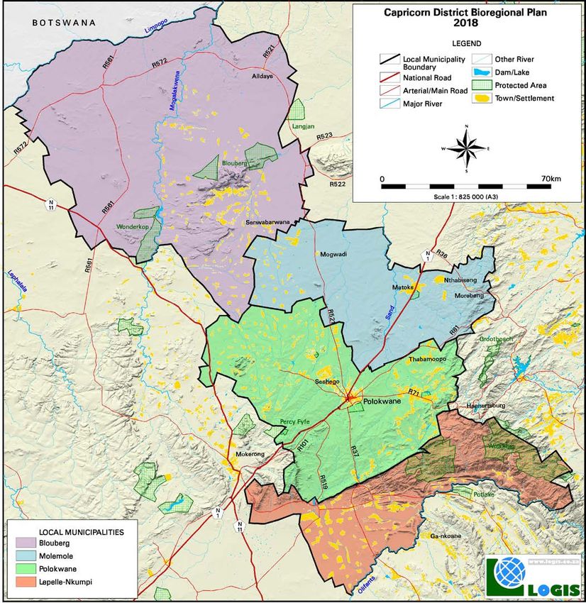
The purpose of this draft bioregional plan document is to provide the reader with the look and feel of the layout
and content of the final bioregional plan document. As such, much of the district specific information is not final or
has not been gathered yet. The purpose of the stakeholder engagement process is to achieve this. This
document is based on the Waterberg, Mopani and Vhembe District bioregional plans, so where we do not have
the final content for this document we give representative examples of the final text from these other bioregional
plans. Where this is done, the text is highlighted in RED.

We encourage the reader to critically apraise this document and to provide the authors with written feedback on
where the document can be improved. We can be contacted at the following email addresses:

Bryony van Niekerk - bryony@nuleafsa.co.za
Philip Desmet - drphil@ecosolgis.com

Your valued consideration is greatly appreciated.

Preface
This is the first bioregional plan for the Capricorn District Municipality and, therefore, does not replace any
existing bioregional plan. The Capricorn District Municipality (CDM) falls within the Limpopo Province of South
Africa and is comprised of Blouberg, Lepelle-Nkumpi, Molemole and Polokwane Local Municipalities. The
bioregional plan for the CDM covers the extent of the district municipal boundaries.

The bioregional plan serves as the primary biodiversity informant to a range of planning and land-use
authorisation processes, although it is important to recognise that the bioregional plan does not replace any
planning and decision-making processes and does not grant, limit or remove land-use rights.

NuLeaf Planning and Environmental (Pty) Ltd compiled the Capricorn District Bioregional Plan with support from
the Limpopo Department of Economic Development, Environment and Tourism (LEDET), the South African
National Biodiversity Institute (SANBI), South African National Parks (SANParks) and various stakeholders within
the Capricorn District.

This bioregional plan was developed in 2018 and is based on data sets and information available at that time.
The Critical Biodiversity Areas (CBAs) and Ecological Support Areas (ESAs) forming part of the Limpopo
Conservation Plan V2, 2013 (LCPv2) were discussed in terms of physical aspects and various planning
instruments and informants. Additional detail is provided in Appendix 1: Supplementary Information.

During this process, real and potential threats and non-alignment between the LCPv2 and the assessed aspects,
as well as, the various instruments and informants were identified.

A detailed description of the alignment process is contained in the Process and Consultation Report.

Resolutions were agreed upon with key stakeholders, specifically the Local and District Municipalities in
response to potential threats to biodiversity conservation within the District.

                        Capricorn District Bioregional Plan Draft for Comment                                        i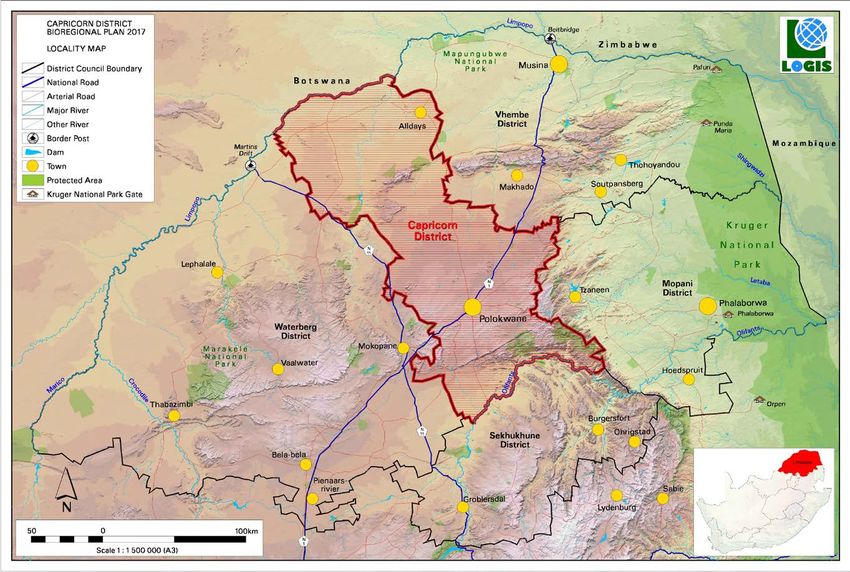
Acknowledgements
Sections of the Capricorn District Bioregional Plan are extracted directly or adapted from the bioregional plans for
the Vhembe, Mopani and Waterberg District Municipalities. These sections pertain specifically to the purpose,
objectives, users, monitoring and review of bioregional plans.

The Guideline Regarding the Determination of Bioregions and the Preparation and Publication of Bioregional
Plans (DEAT, 2009) was also used extensively to guide the report structure and content.

The Map of Critical Biodiversity Areas for the Capricorn District Municipality is based on the provincial product
developed in the Limpopo Conservation Plan V2 (Desmet et al., 2013).

Acknowledgements are extended to all the stakeholders within the Capricorn District Municipality who
contributed to the alignment of this bioregional plan with the spatial plans, programmes and policies applicable to
the Capricorn District Municipality. Special thanks are extended to the following persons:

Karen Steenkamp (LEDET)
Errol Moeng (LEDET)
Grace Matseba (SALGA)
Theo van Rooyen (Capricorn District Municipality)
Arnot Ravele (Capricorn District Municipality)

                        Capricorn District Bioregional Plan Draft for Comment                                     ii
Contents
Preface .......................................................................................................................................... i
Acknowledgements ......................................................................................................................... ii
Contents ...................................................................................................................................... iii
List of Tables.................................................................................................................................. v
List of Figures................................................................................................................................. v
List of Appendices ........................................................................................................................... v
List of Abbreviations ........................................................................................................................ v
Executive Summary ....................................................................................................................... vii
PART 1: INTRODUCTION ................................................................................................................ 1
1.1 Purpose and objectives ......................................................................................................... 1
1.2 Need for a bioregional plan .................................................................................................... 2
1.3 Intended users and uses........................................................................................................ 2
1.3.1 Mandatory users ............................................................................................................. 2
1.3.2 Recommended Users ...................................................................................................... 3
1.4 Underlying Biodiversity Plan and limitations ............................................................................... 4
1.5 Physical context ................................................................................................................... 4
PART 2: BIODIVERSITY PROFILE..................................................................................................... 8
2.1 Physical environment ............................................................................................................ 8
2.2 Natural environment ............................................................................................................. 8
2.2.1 Significance of biodiversity .............................................................................................. 8
2.2.2 Terrestrial ecosystems .................................................................................................... 9
2.2.2.1 Threatened ecosystems ............................................................................................. 9
2.2.2.3 Protection level ....................................................................................................... 10
2.2.2.4 Important terrestrial features ...................................................................................... 10
2.2.3 Aquatic ecosystems .......................................................................................................11
2.2.3.1 Freshwater features ..................................................................................................11
2.2.4 Important ecological processes ...................................................................................... 12
2.3 Man-made environment ....................................................................................................... 12
2.3.1 Land cover ................................................................................................................... 12
2.3.2 Mining Activity and Mineral Deposits .............................................................................. 12
2.3.3 Cultural historic features ............................................................................................... 13
2.3.4 Land claims ................................................................................................................. 13
2.4 Planning environment ......................................................................................................... 13
2.4.1 Protected Areas planning .............................................................................................. 13
Capricorn District Bioregional Plan Draft for Comment iii2.4.1.1 Protected Areas ...................................................................................................... 13
2.4.1.2 Conservation areas ................................................................................................. 14
2.4.1.3 Greater Mapungubwe Transfrontier Conservation Area (GMTFCA) Integrated Development Plan
14
2.4.1.4 Protected Area Expansion Strategy............................................................................. 14
2.4.2 Multi sectoral planning .................................................................................................. 15
2.4.2.1 Environmental Management Framework ...................................................................... 15
2.4.2.2 Integrated Development Plans ................................................................................... 15
2.4.2.3 Spatial Development Frameworks .............................................................................. 15
2.4.3 Other informants .......................................................................................................... 16
2.4.3.1 Biosphere Reserves ..................................................................................................... 16
2.4.3.2 National Freshwater Ecosystem Priority Areas .............................................................. 16
2.4.3.3 Strategic Water Source Areas .................................................................................... 16
2.4.3.4 Important Bird Areas .................................................................................................17
2.4.3.5 Centres of Endemism................................................................................................17
PART 3: CRITICAL BIODIVERSITY AREAS ....................................................................................... 18
PART 4: GUIDELINES FOR DECISION MAKING ................................................................................ 22
4.1 Land management objectives and land-use guidelines............................................................... 22
4.1.1 Protected Areas ............................................................................................................ 22
4.1.2 Critical Biodiversity Areas (CBA1 and CBA2) ................................................................... 23
4.1.3 Ecological support Areas (ESA1) .................................................................................... 25
4.1.4 Ecological support Areas (ESA2) .................................................................................... 27
4.2 Additional guidelines ........................................................................................................... 28
PART 5: ADDITIONAL MEASURES.................................................................................................. 29
5.1 Data collation and management ............................................................................................ 29
5.2 Capacity building................................................................................................................ 29
5.3 Effective biodiversity management ......................................................................................... 29
5.3.1 Invasive alien management ............................................................................................ 29
5.3.2 Biodiversity management plans...................................................................................... 30
5.3.3 Protected Area expansion .............................................................................................. 30
5.3.4 Biodiversity offsets ....................................................................................................... 30
5.3.5 River health.................................................................................................................. 31
5.3.6 Priority areas for rehabilitation ....................................................................................... 31
5.4 Building a biodiversity economy ............................................................................................ 32
5.4.1 Ecotourism .................................................................................................................. 32
5.4.2 Wildlife economy .......................................................................................................... 32
Capricorn District Bioregional Plan Draft for Comment iv5.4.3 Skills development and training...................................................................................... 32
5.4.4 Natural resource use ..................................................................................................... 32
5.4.5 Expanded Public Works Programme ............................................................................... 33
5.5 Awareness raising .............................................................................................................. 33
PART 6: MONITORING AND REVIEW .............................................................................................. 34
6.1 Role and Resonsibilities ...................................................................................................... 34
6.2 Performance indicators........................................................................................................ 35
6.3 Review............................................................................................................................. 35
6.4 Updating .......................................................................................................................... 36
PART 7: GIS FILES ........................................................................................................................37
REFERENCES ............................................................................................................................. 38
APPENDIX 1- SUPPLEMENTARY INFORMATION.............................................................................. 41
List of Tables
Table 1: Summary of map categories
Table 2: Extent of Critical Biodiversity Areas in Capricorn District as per the LCPv2
Table 3: Guidelines: Protected Areas
Table 4: Guidelines: CBA1 and CBA2
Table 5: Guidelines: ESA1
Table 6: Guidelines: ESA2
Table 7: Summary of roles and responsibilities for monitoring and review of the Capricorn District
Municipality Bioregional Plan
List of Figures
Figure 1: Location of the Capricorn District
Figure 2: Local Municipalities in the Capricorn District- new designations
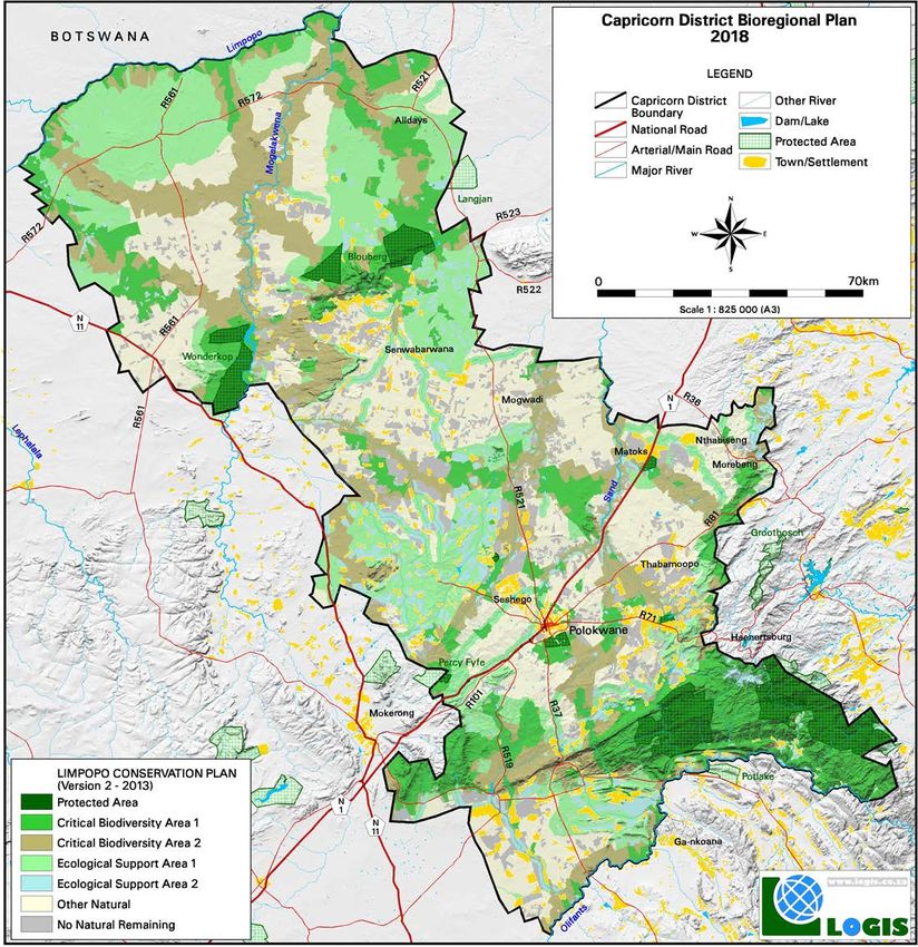
Figure 3: Map of Critical Biodiversity Areas and Ecological Support Areas for the Capricorn District
List of Appendices
Appendix 1: Supplementary Information
List of Abbreviations
CBA Critical Biodiversity Area
CBD Convention of Biological Diversity
CDBRP Capricorn District Bioregional Plan
CDM Capricorn District Municipality
CSIR Council for Scientific and Industrial Research
DEA Department of Environmental Affairs
DMR Department of Mineral Resources
DWS Department of Water and Sanitation
Capricorn District Bioregional Plan Draft for Comment vEA Environmental Authorisation
EAP Environmental Assessment Practitioner
EIA Environmental Impact Assessment
EIP Environmental Implementation Plan
EMF Environmental Management Framework
EMPr Environmental Management Programme
EPWP Extended Pubic Works Programme
ESA Ecological Support Area
GIS Geographic Information System
GLTFCA Greater Limpopo Transfrontier Conservation Area
Ha Hectares
IBA Important Bird Area
IDP Integrated Development Plan
ILU Integrated land Use
IUCN International Union for Conservation of Nature
LCPv2 Limpopo Conservation Plan Version 2, 2013
LEDET Limpopo Department of Economic Development, Environment and Tourism
MEC Member of the Executive Committee
MSA Municipal Systems Act (Act No. 32 of 2000)
NBA National Biodiversity Assessment, 2011
NBF National Biodiversity Framework
NEMA National Environmental Management Act (Act No. 107 of 1998)
NEM:BA National Environmental Management: Biodiversity Act (Act No. 10 of 2004), referred to in this
document as the Biodiversity Act
NEM:PAA National Environmental Management: Protected Areas Act (Act No. 57 of 2003) referred to in
this document as the Protected Areas Act
NFEPA National Freshwater Ecosystem Priority Areas
NGO Non-Governmental Organisation
NNR No Natural (Habitat) Remaining
NSBA National Spatial Biodiversity Assessment, 2004
NWA National Water Act (Act No. 36 of 1998)
OLCEMF Olifants and Letaba Catchment Environmental Management Framework
ONA Other Natural Areas
PES Present Ecological State
PNR Private Nature Reserve
SANBI South African National Biodiversity Institute
SANParks South African National Parks
SAPAD South African Protected Area Database
SDF Spatial Development Framework
SEA Strategic Environmental Assessment
SEMP Strategic Environmental Management Plan
SEZ Special Economic Zone
SPLUMA Spatial Planning and Land Use Management Act (Act No. 16 of 2013)
UNESCO United Nations Educational, Scientific and Cultural Organisation
WHS World Heritage Site
Capricorn District Bioregional Plan Draft for Comment viExecutive Summary
Purpose and objectives:
The declaring of bioregions and the gazetting of bioregional plans forms part of the legislated tools identified by
the National Environmental Management: Biodiversity Act (Act No. 10 of 2004), hereafter referred to as the
Biodiversity Act, to aid in the conservation and management of South Africa’s biodiversity.
The purpose of a bioregional plan is to facilitate the safeguarding of biodiversity within identified biodiversity
priority areas that fall outside of the Protected Area (PA) Network, as well as, to provide a map of biodiversity
priorities with accompanying land use planning and decision-making guidelines to inform land-use planning,
environmental assessment and authorisations, and natural resource management.
Intended users and uses:
The bioregional plan has both mandatory and recommended users. Mandatory users are obligated to take the
bioregional plan into consideration, while recommended users could find the bioregional plan to be a useful
planning and development tool.
Underlying biodiversity plan:
The Capricorn District Bioregional Plan is based on the Critical Biodiversity Area (CBA) maps developed in the
Limpopo Conservation Plan V2, 2013 the current systematic biodiversity plan for the province undertaken by the
Limpopo Department of Economic Development, Environment and Tourism (LEDET).
Physical context:
Capricorn District municipality is situated in the centre of the Limpopo Province. It shares its borders with four
district municipalities namely; Mopani (east), Sekhukhune (south), Vhembe (north) and Waterberg (west). There
are four (4) Local Municipalities (LMs), namely:
• Blouberg LM (9 540 km2)
• Molemole LM (3 628 km2)
• Polokwane LM (5 054 km2)
• Lepelle-Nkumpi LM (3 484 km2)
Significance of biodiversity:
Sekhukhune District Municipality has 23 different vegetation types. Eight of the 23 vegetation types are classified
as Threatened ecosystems, whereby four (4) are classified as Endangered (Malmani Karstlands, Sekhukhune
Mountainlands, Sekhukhune Norite Bushveld and Tzaneen Sour Lowveld) and four (4) are classified as
Vulnerable (Northern Escarpment Dolomite Grassland, Rand Highveld Grassland, Sekhukhune Plains Bushveld
and Springbokvlakte Thornveld)
Four (4) of the vegetation types occurring within the District are classified as endemic and two (2) as near-
endemic.
Planning environment:
Many instruments and informants were addressed in terms of understanding the status quo of the planning
environment relating to biodiversity conservation and planning within the District inclusive of Protected Areas
planning (Protected Areas, National Protected Areas Expansion Strategy), Multi sectoral planning (Spatial
Development Frameworks, Integrated Development Plans) and Other Informants (Important Bird Areas).
Capricorn District Bioregional Plan Draft for Comment viiCritical Biodiversity Areas:
One of the outputs of the LCPv2 is a map of Critical Biodiversity Areas (CBAs) and Ecological Support Areas
(ESAs). These are classified into these different categories based on biodiversity characteristics, spatial
configuration and requirement for meeting targets for both biodiversity pattern and ecological processes.
• Protected Areas are declared and formally protected under the National Environmental Management:
Protected Areas Act, 2003 (Act No 57 of 2003), hereafter referred to as the Protected Areas Act. These
include National Parks, Nature Reserves, World Heritage Sites and Protected Environments that are
secured by appropriate legal mechanisms.
• Critical Biodiversity Areas are sites that are required to meet biodiversity targets for ecosystems and
species, and need to be maintained in good ecological condition. The majority of the CBAs in the
Capricorn District are CBA 1, which can be considered irreplaceable in that there is little choice in terms
of areas available to meet targets. Those areas falling within CBA 2 are considered optimal. Although
they represent areas where there are other spatial options for achieving targets, the selected sites are
the ones that best achieve targets of the systematic biodiversity plan.
• Ecological Support Areas (ESAs) are areas that are important for supporting the ecological functioning
of CBAs and protected areas and for meeting biodiversity targets for ecological processes. This
category has also been split into ESA1 and ESA2 on the basis of land cover. ESA1s are in a largely
natural state, while ESA2s are no longer intact but potentially retain significant importance from an
ecological process perspective (e.g. agricultural land maintaining landscape connectivity).
• Other Natural Areas (ONAs) are areas that still contain natural habitat but that are not required to meet
biodiversity targets.
• No Natural Areas Remaining are areas without intact habitat remaining.
Capricorn District Bioregional Plan:
The bioregional plan for the Capricorn District Municipality is based on the Limpopo Conservation Plan v2
(Desmet et al., 2013) and adapted to take into account stakeholder comments, threats and agreed resolutions.
The format and content of this document is based on the Vhembe District Bioregional Plan.
In response to potential losses and threats identified during the alignment process undertaken during the
development of the Capricorn District Bioregional Plan, the CBAs and ESAs of the LCPv2 required updating in
order to ensure that biodiversity targets remained intact within the District.
Guidelines for decision-making:
These guidelines provide a framework for land-uses compatible with the land management objectives of each
category on the Map of CBAs. The guidelines are designed to aid planners to identify the appropriate zones and
controls to impose on areas designated as Critical Biodiversity Areas or Ecological Support Areas.
Importantly, the Capricorn District Bioregional Plan provides guidance on appropriate land uses and does not
grant or remove existing land-use rights or take the place of development application authorisation processes.
The guidelines should be used in conjunction with other sector-specific guidelines applicable within the Province,
such as Mining and Biodiversity Guideline (SANBI, 2013), Atlas of Freshwater Ecosystem Priority Areas for
South Africa (Nel et al., 2011), Limpopo Protected Area Expansion Strategy Technical Report (Desmet et al,
2014), Implementation Manual for Freshwater Ecosystem Priority Areas (Driver et al., 2011).
Additional measures:
In addition to the guidelines for decision-making, the bioregional plan recommends additional measures to
support biodiversity management, conservation and planning within the Capricorn District Municipality. These
include the Data collation and management, Capacity building, Effective biodiversity management, Building a
biodiversity economy and Awareness raising.
Capricorn District Bioregional Plan Draft for Comment viiiMonitoring and review:
The primary purpose of on-going monitoring is to evaluate the on-going implementation of the bioregional plan. In
this respect, implementation indicators are proposed which do not require investment into baseline biodiversity
data gathering, but rather focus on the evaluation of the implementation mechanism. This should allow indicators
to be evaluated on at least an annual basis.
However, it will be necessary to evaluate the biodiversity outcome of the implementation of the bioregional plan
in order to conduct the required five-year review of the bioregional plan. Additional biodiversity indicators have
been proposed in this regard.
The bioregional plan must be reviewed and updated (where necessary) at least every five years. Should the
review process indicate that it is necessary to update the bioregional plan or components of the bioregional plan,
then this should be undertaken and the revised bioregional plan should be re-submitted to the Member of the
Executive Committee (MEC) for approval. Ideally, this should be timed to precede the revision cycle for municipal
SDFs.
Although the CDM is the lead implementing agency for the Capricorn District Bioregional Plan, LEDET is the
agency responsible for the update of the Capricorn District Bioregional Plan as required.
Capricorn District Bioregional Plan Draft for Comment ixPART 1: INTRODUCTION
This is the first bioregional plan for the Capricorn District Municipality and, therefore, does not replace any
existing bioregional plan. The Capricorn District Municipality (CDM) falls within the Limpopo Province of South
Africa and is comprised of Blouberg, Molemole, Polokwane and Lepelle-Nkumpi Local Municipalities. The
bioregional plan for the CDM covers the extent of the district municipal boundaries.
The bioregional plan serves as the primary biodiversity informant to a range of planning and land-use
authorisation processes, although it is important to recognise that the bioregional plan does not replace any
planning and decision-making processes and does not grant, limit or remove land-use rights.
Mining, industry, agriculture and tourism are the main economic sectors in Capricorn District. The CDM is home
number of Natural Heritage Sites such as Brackenhill, Goedehoop, Makgabeng Rock Art and the ZCC pilgrimage
(Moria). Cultivated land is scattered throughtout the District.
These primary activities result in habitat modification, land degradation and ultimately the loss of biodiversity
within the affected areas. Additionally, the Capricorn District has experienced a steady population growth of 1.1
% per annum since 2011 to 2016 and projects a growth rate of 0.7% per annum for a period up tp year 2030
(Source: Capricorn Growth and Development Strategy: 2030).This places further pressure on already stressed
natural resources in the municipality. The bioregional plan for the Capricorn District is, therefore, an appropriate
tool for addressing the management and conservation of biodiversity.
1.1 Purpose and objectives
The declaring of bioregions and the gazetting of bioregional plans forms part of the legislated tools identified by
the National Environmental Management: Biodiversity Act, 2004 (Act No. 10 of 2004), hereafter referred to as the
Biodiversity Act, to aid in the conservation and management of South Africa’s biodiversity.
The purpose of a bioregional plan is to facilitate the safeguarding of biodiversity within identified biodiversity
priority areas that fall outside of the Protected Area (PA) Network (NEMA, 2004).
Additionally, the aim of a bioregional plan is to provide a map of biodiversity priorities with accompanying land
use planning and decision making guidelines to inform land-use planning, environmental assessment and
authorisations, and natural resource management by a range of sectors whose policies and decisions impact on
biodiversity. Bioregional plans are intended to feed into multi-sectoral planning and assessment processes such
as Environmental Management Frameworks (EMFs), Spatial Development Frameworks (SDFs), Strategic
Environmental Assessments (SEAs) and Environmental Impact Assessments (EIAs) (DEAT, 2009). A bioregional
plan is the biodiversity sector's input into various multi-sectoral planning and authorisation processes.
The Capricorn District Bioregional Plan is consistent with the National Environmental Management Act (Act No.
107 of 1998), the Biodiversity Act and the National Biodiversity Framework (NBF) in that the bioregional plan
identifies and recognizes Critical Biodiversity Areas (CBAs) and provides guidelines for the management and
conservation thereof. Furthermore, it also supports the principles of integrated development planning and
sustainable development by ensuring that the CBAs identified are not in conflict with other land-use activities.
The bioregional plan provides a spatial representative of CBAs and Ecological Support Areas (ESAs) within the
Capricorn District Municipality. CBAs and ESAs are areas required to meet targets for biodiversity pattern and /
or ecological processes. The bioregional plan aligns CBAs and ESAs with existing planning instruments and / or
requires alignment by existing instruments. The primary objectives of the bioregional plan are:
• To avoid and/ or prevent loss and degradation of biodiversity in the priority areas (CBAs, ESAs);
• To inform land-use planning and decision-making.
Capricorn District Bioregional Plan Draft for Comment 11.2 Need for a bioregional plan
A bioregional plan for the Capricorn District Municipality is warranted based on the following:
• Biodiversity value: Capricorn District has a range of diverse ecosystems which support many
threatened flora and fauna. These ecosystems include savanna, grasslands, indigenous forests,
mountain escarpments (Blouberg and Wolkberg) and numerous wetlands Two Important Birding and
Biodiversity Areas occur within the municipality. More than half of the Capricorn District is covered by
endemic and near endemic vegetation and 6 ecosystem types are listed as threatened in the National
Biodiversity Assessment of 2011 (NBA).
• Pressures on biodiversity: Agriculture expansion, human settlement expansion and new mining
developments are the main pressure sources that are exerted on biodiversity within the Capricorn
District. Uncontrolled creep of rural and urban settlements and associated land uses threaten to
encroach on CBAs and ESAs alike. There are many active mines in the CDM, where majority are
centred around Polokwane and then extend south. A coal field is located in the northern portion of CDM
in the Blouberg LM, as well as, in the southwest corner of the District in Lepelle-Nkumpi LM. This coal
belt in the north is located within a centre of endemism, the Vhembe Biospheree Reserve and protected
areas.
• Protection of biodiversity: The Limpopo Protected Area Expansion Strategy (LPAES, 2014) plays a
central role in conserving biodiversity through the creation of formal protected areas. This strategy,
however, is only one of a suite of mechanisms in aimed at protecting the natural environment. Other
important mechanisms that focus environmental management of the whole landscape include this
bioregional plan as well as integrated of municipal management and environmental planning tools such
as, SDFs, EMFs and SEAs.
1.3 Intended users and uses
The bioregional plan has both mandatory and recommended users. Mandatory users are obligated to take the
bioregional plan into consideration, while recommended users could find the bioregional plan to be a useful
planning and development tool.
The intended users of the bioregional plan, as stated in the Biodiversity Act (DEAT, 2009) are as follows:
1.3.1 Mandatory users
• Local and District Municipalities i.e. Capricorn District Municipality and the 4 local municipalities which
fall within it. All CBAs identified in the bioregional plan must align with municipal planning tools (i.e.
SDFs) or vice versa.
• Any organ of state that must prepare an Environmental Implementation Plan (EIP) or Environmental
Management Framework (EMF) in terms of Chapter 3 of National Environmental Management Act,
1998 (Act No 107 of 1998).
• Environmental decision makers who are required by section 2(1)(6) of NEMA to apply the NEMA
section 2 principles in their decision-making:
National:
o National Department of Environmental Affairs (DEA);
o National Department of Agriculture, Forestry and Fisheries (DAFF) which should take
bioregions(s), bioregional plan(s) and identified Critical Biodiversity Areas into account in their
authorisations (e.g. for ploughing virgin land, and for subdivision of agricultural land);
Capricorn District Bioregional Plan Draft for Comment 2o Department of Water and Sanitation (DWS) which should take bioregion(s), bioregional plan(s) and
identified Critical Biodiversity Areas into account in their decision-making, for example in granting
water licences;
o Department of Mineral Resources (DMR) which should take bioregion(s), bioregional plan(s) and
identified Critical Biodiversity Areas into account in their authorisations for prospecting and mining.
Provincial:
o Limpopo Department of Economic Development, Environment and Tourism (LEDET);
o Limpopo Department of Agriculture (LDA) which should take bioregions, bioregional plans and
identified Critical Biodiversity Areas into account in their comments on applications;
o Co-operative Governance, Human Settlement and Traditional Affairs (CoGHSTA);
o Department of Public Works, Roads and Infrastructure (LDPW);
o Local and District Municipalities which should take account of bioregion(s), bioregional plan(s) and
identified CBAs in issuing planning authorisations.
1.3.2 Recommended Users
• Government departments and agencies whose decisions and actions impact on biodiversity and the
natural environment, but whose core business and expertise is not biodiversity conservation:
o Local and District Municipalities should integrate CBAs and other relevant guidelines and
recommendations from the bioregional plan into EMFs.
o National and Provincial environmental departments should take the provisions of bioregional plans
into account in the development of provincial supplements to NEMA, EIA regulations, EMFs and
National and Provincial Guidelines.
o Provincial conservation authorities should use bioregional plans to guide their inputs into land-use
planning, land-use decision-making and natural resource management, if they have these
functions.
o Provincial departments responsible for spatial planning should take bioregional plans into account
in the development of Provincial SDFs.
o Catchment management agencies should integrate the relevant bioregional plan(s) in their
Catchment Management Strategies and their planning about water allocations.
o Department of Rural Development and Land Reform should take bioregional plans into account in
planning and implementing land reform programmes, and in the development of policy, legislation
or guidelines for land-use planning and management.
o The Department of Human Settlement should avoid CBAs in identifying suitable sites for new
housing developments.
o The Department of Public Works should take bioregional plans into account in identifying
appropriate locations and routes for roads and other infrastructure.
• Working for Water, Working for Wetlands, Land Care and other programmes that deal with maintaining
and restoring natural resources, should take bioregional plans into account in planning and scheduling
their activities, prioritising CBAs where possible.
• Environmental and planning consultants undertaking Strategic Environmental Assessments (SEAs),
EIAs, or the development of IDPs, SDFs or EMFs for a municipality.
• Conservation Non-Government Organisations (NGOs), whose core business is biodiversity
conservation. These organisations should use bioregional plans to guide their comments on planning
tools such as SDFs and on development applications.
• Private landowners - individuals and companies who want more information about the biodiversity value
of their landholdings and who wish to make a contribution to conserving the nation's natural heritage by
Capricorn District Bioregional Plan Draft for Comment 3ensuring that the use of their land is compatible with biodiversity conservation and/or by securing priority
sites in stewardship contracts.
1.4 Underlying Biodiversity Plan and limitations
A bioregional plan must be a spatial plan showing terrestrial and aquatic features in the landscape that are
critical for conserving biodiversity and maintaining ecosystem functioning.
The Capricorn District Bioregional Plan is based on the CBA maps developed in the Limpopo Conservation Plan
version 2 (2013), the current systematic biodiversity plan for the province undertaken by the Limpopo
Department of Economic Development, Environment and Tourism (LEDET).
A systematic biodiversity plan is a plan that identifies priority areas for biodiversity conservation based on
internationally recognised systematic biodiversity planning principles, methodologies and techniques. A
systematic biodiversity plan should possess four crucial features, namely: the principles of representation and
persistence, setting of quantitative biodiversity targets, and efficiency and conflict avoidance in the spatial
configuration (DEAT, 2009).
The Limpopo Conservation Plan v2, 2013 fulfils all of these requirements. A revised and updated version of the
vegetation types described in Mucina and Rutherford (2006) was utilized and wetland and river systems were
included, as well as, data on the distribution and habitat of threatened species. The LCPv2 also focuses on three
key aspects (namely climate change, hydrological processes and species requirements) to ensure that
biodiversity persists in the future. Additionally, biodiversity targets were set for both biodiversity pattern and
ecological process features indicating how much of each feature is required to ensure representation and
persistence (Desmet, Holness, Skowno and Egan, 2013).
The following limitations apply to this bioregional plan:
• The bioregional plan does not negate the need for site assessments, particularly EIAs required in terms
of NEMA. On site verification of identified CBAs and ESAs is still required.
• The systematic biodiversity plan is designed to be used on a 1:50 000 scale which provides a broad
overview of the entire Limpopo Province. While this plan can be used at a finer scale, specialist
interpretation of the specific features identified will be required on a site level.
• The LCPv2 was developed using nationally prescribed methods and based on the best available data at
the time of its development. The limitation of input data needs to be acknowledged during development
planning processes, particularly at the site-level.
• Continuous changes to land use and land use patterns may result in encroachment into natural areas /
CBAs, and as a result, additional areas may need to be reassigned or designated as CBAs in order to
meet biodiversity targets as set out in the Limpopo Conservation Plan.
1.5 Physical context
Capricorn District municipality is situated in the centre of the Limpopo Province. It shares its borders with four
district municipalities namely; Mopani (east), Sekhukhune (south), Vhembe (north) and Waterberg (west). The
district is situated at the core of economic development in the Limpopo Province and includes the capital of the
province, the City of Polokwane. It is bordered by Botswana to the north. The Limpopo river valley forms the
border between the District and its International neighbour.
The District spans a total area of 2 170 594 Ha (21 705 km²) which extends north from the Olifants River to the
border of Botswana.
Capricorn District Bioregional Plan Draft for Comment 4Refer to Figure 1.
Capricorn District Municipality consists of four Local Municipalities (LMs), namely:
• Blouberg LM (9 540 km2)
• Molemole LM (3 628 km2)
• Polokwane LM (5 054 km2)
• Lepelle-Nkumpi LM (3 484 km2)
Up until recently, Aganang Local Municipality formed part of Capricorn District Municipality. However, after the
August 2016 municipal elections, Aganang LM was disestablished and its municipal boundaries were merged
into Blouberg, Molemole and Polokwane LM.
Refer to Figure 2.
Capricorn District Bioregional Plan Draft for Comment 5Figure 1: Location of the Capricorn District
Capricorn District Bioregional Plan Draft for Comment 6Figure 2: Local Municipalities in the Capricorn District - new designations
Capricorn District Bioregional Plan Draft for Comment 7PART 2: BIODIVERSITY PROFILE
2.1 Physical environment
The majority of the CDM landscape is characterised by level to undulating plains (more than 90% of the area has
slopes of less than 7%). Steep slopes and ridges are localised, and might constrain development in such areas.
Generally, the northern parts of the district are more evenly sloped than the southern parts.
The northern and southern borders of the Capricorn District are defined by water courses, namely the Limpopo to
the north and Olifants River to the south. Subsequently, the area falls within two water management areas
(WMAs): Limpopo WMA (north) covering the majority part of the District; and the Olifants WMA (south) – from
Lebowakgomo southwards (Capricorn District Municipal Spatial Development Framework, 2017).
In the Limpopo WMA the Mogalakwena River flows towards the western part, and the Sand River and its
tributaries (three in total) flow through the central parts of the District from south to north, past Polokwane
towards Musina. The main tributaries in the Olifants WMA are the Wilge, Elands, Ga-Selati, Steelpoort, Blyde,
Klaserie and Timbavati Rivers but none of these occur in the Capricorn area – apart from the Olifants River itself.
Refer to Appendix 1 for additional information in this regard.
2.2 Natural environment
2.2.1 Significance of biodiversity
The Savanna biome covers approximately 65% of the Capricorn District with the remainder being made up of
Forest (4%), Grassland (19%) and Azonal (11%) biomes.
Capricorn District has 26 different vegetation types. Six of the 26 vegetation types are classified as Threatened
ecosystems, namely Sekhukhune Plains Bushveld, Polokwane Plateau Bushveld and Spingbokvlakte Thornveld
which is classified as Vulnerable in the national list of threatened ecosystems published in terms of the
Biodiversity Act (DEA, 2011). Tzaneen Sour Lowveld and Sekhukune Norite Bushveld are classified as
Endangered, while It should also be noted that Woodbush Granite Grassland, located on the eastern border of
the District in the south eastern portion of the District, is classified as Critically Endangered.
Fifteen (15) of the vegetation types occurring within the District are classified as endemic and two (2) as near-
endemic.
Three centres of endemism can be found within the CDM, namely; the Soutpansberg, Wolkberg and
Sekhukhuneland Centres of Endemism. The Soutpansberg Centre of Endemism, the northern most mountain
range in South Africa, stretches from east to west covering an area close to 130 Km. The Soutpansberg is truly
diverse and home to approximately 2500-3000 recorded vascular plant taxa, 594 tree taxa, 510 bird species, 116
reptile species and 145 mammal species (The Soutpansberg, 2003). This area also functions as an important
biodiversity hotspot, ecological corridor, centre of endemism, Important Bird Area and Strategic Water Source
Area.
A small part of both the Wolkberg and Sekhukhuneland Centres of Endemism are located in the southern portion
of the CDM.
Designated Protected Areas (in terms of South African Protected Area Database 2017 (SAPAD)) covers 8.4% of
the District.
73% of the vegetation types found in the District are under-protected which is the collective term used to refer to
ecosystems that are unprotected, poorly protected and moderately protected.
Capricorn District Bioregional Plan Draft for Comment 8In addition, the Haenertsburg-Modjadji focus region is one of the highest scoring sites in the province, being
particularly valuable in terms of Freshwater features and Critical Biodiversity Areas. Other high value Focus
Regions located in the District are Blouberg and Drankensberg-Stydpoortberge.
2.2.2 Terrestrial ecosystems
2.2.2.1 Threatened ecosystems
Ecosystem threat status refers to the degree to which an ecosystem is still intact, or alternatively losing vital
aspects of its structure, function or composition. Ecosystems are listed as threatened based on their risk of
extinction as a result of irreversible loss of natural habitat, ecosystem degradation and loss of integrity. The main
purpose of listing threatened ecosystems is, therefore, to counteract this risk.
• Vulnerable ecosystems are located in the south of the District, extending predominantly to the south of the
Wolkberg Mountains.
o Polokwane Plateau Bushveld
o Sekhukhune Plains Bushveld
o Springbokvlakte Thornveld
• Endangered ecosystem is located
o Tzaneen Sour Lowveld
o Sekhukune Norite Bushveld
• Critically Endangered ecosystem is located in small pockets along the south eastern boundary of the
District
o Woodbush Granite Grassland
Based on analysis done for LCPv2, Tzaneen Sour Bushveld has changed from Vulnerable (NBA 2011) to
Endangered, based on high levels of natural habitat conversion (>35%), as well as high levels of degradation
due to alien vegetation and proximity to rural settlements that is not captured in the land-cover. This is not an
application of a new criterion for listing of threatened ecosystems but rather the application of existing criteria (A1
and A2) where the quantitative assessment using only land-cover has been adjusted based on expert
information relating to incompletely mapped degradation. This change is not yet reflected in the national list of
threatened ecosystems. Additionally, Sekhukhune Plains Bushveld has been adjusted from Least Threatened to
Vulnerable based on: a) high levels of natural habitat conversion (>30%); b) better finer-scale sub-vegetation
type mapping of features; and, c) high endemism.
Three information sources were consulted, the LCPv2, 2013, the NBA and updated ES2017 to determine the
ecosystem threat status. Where there are conflicting threat statuses, the highest designation was used.
Refer to Appendix 1 for additional information in this regard.
2.2.2.2 Level of endemism
65% of the vegetation in the District is classified as endemic or near endemic (i.e. 58% endemic and 8% near-
endemic).
Endemic ecosystems predominately cover the southern portion of the Capricorn District Municipality. Small
pockets of endemic vegetation are found near the centre of the District near Blouberg Nature Reserve. Near
endemic vegetation fringes the edges of the endemic vegetation in the south. The remainder of the District is
covered with non-endemic vegetation.
Refer to Appendix 1 for additional information in this regard.
Capricorn District Bioregional Plan Draft for Comment 92.2.2.3 Protection level
Ecosystem types are categorised as not protected, poorly protected, moderately protected or well protected,
based on the proportion of each ecosystem type that occurs within a Protected Area (PA) recognised under the
Protected Areas Act.
In terms of the LCPv2, Protected Areas cover 4% of the Capricorn District Municipality.
Designated PAs in terms of SAPAD 2017 cover 8.4% of the Capricorn District Municipality.
Within Capricorn District, 73% of the ecosystems are under protected. Five (5) ecosystems are not protected at
all, thirteen (13) ecosystems are poorly protected inclusive of the Endangered Tzaneen Sour Lowveld, as well
as, the Critically Endangered Woodbush Granite Grassland, and one (1) ecosystem is moderately protected, well
six (6) are well protected.
In general, small pockets of well protected ecosystems are located in the far north and far south, moderately
protected ecosystems lie in the southern part of the District which correlates with a centre of endemism. Poorly
protected ecosystems span the northern and southern portions of the CDM, while the centre is not protected at
all.
Refer to Appendix 1 for additional information in this regard.
2.2.2.4 Important terrestrial features
Threatened species:
Plants:
Both the Soutpansberg Centre of Endemism and the Wolkberg Centre of Endemism (Northern Mistbelt Forest)
can be found in the district, as such the northern portion of the Disrict is truly diverse and home to approximately
2500-3000 recorded vascular plant taxa and 594 tree taxa of which 50 are endemic. Whereas, the southern
section consisting of the Wolkberg flora, is prolific with more than 40 species endemic or near endemic to the
dolomites, and 90 species to the quartz and shale derived substrates.
38 endemic plant taxa are known to occur in the Soutpansberg, where approximately 58% occur within the mist
belt region and where 30% are restricted to it.
41% of all plant genera and 68% of all plant families occurring in the southern African region are represented in
the Soutpansberg Centre of Endemism (Hahn, 2017).
The Blouberg Nature Reserve is home to South Africa’s largest concentration of Baobabs- a nationally protected
tree species. These majestic trees can grow up to 25 m in height, 28 m in circumference and can live up to 3000
years old (Musina Nature Reserve, 2017).
Mammals:
Samango Monkey Cercopithecus albogularis, Ground Pangolin Manis temminckii and Leopard Panthera pardus
are threatened mammals that occur in the Soutpansberg. Yellow Golden mole Calcochloris obtusirostris (Near
Threatened), Four-toed Elephant-shrew Petrodromus tetradactylus (Near Threatened), Water Rat Dasymys
robertsii (Vulnerable), Schwarz’s White-collared Money Cercopithecus albogularis schwarzi (Endangered),
Thin Mouse Shrew Myosorex cf. tenuis (Endangered, restricted to the Soutpansberg), African Wild Dog Lycaon
pictus (Endangered) are all found within the Capricorn District.
Gunning’s Golden Mole, Amblysomus gunning, (Endangered) is endemic to Limpopo. They are known only to
occur in the Grootbosch Forest and the Agatha Forest Reserve.
Capricorn District Bioregional Plan Draft for Comment 10Reptiles:
Blouberg is home to the orange-throated flat lizard Platysaurus monotropis, which is endemic to this set of
inselbergs. The global ranges of the dwarf flat lizard Platysaurus guttatus and black-spotted dwarf gecko
Lygodactylus nigropuncatus are restricted to Blouberg (Birdlife South Africa, 2015).
The Soutpansberg rock lizard Australolacerta rupicola, Warren's Girdled Lizard Cordylus warreni and Spotted
Dwarf Gecko Lygodactylus ocellatus, Soutpansberg worm lizard, Soutpansberg dwarf gecko and the
Soutpansberg flat lizard are all endemic to the mountain range.
Methuens Dwarf Gecko, Lygodactylus methueni, (Vulnerable) are endemic to the Woodbush Forest area and
Haenertsburg Common.
Birds:
Cape Vulture is a globally threatened species. Common biome-restricted species are Kurrichane Thrush
Turdus libonyanus, White-throated Robin-Chat, Gorgeous Bush-Shrike and White-bellied Sunbird Cinnyris
talatala. Uncommon biome-restricted species are Kalahari Scrub Robin and Barred Wren-Warbler (Birdlife
South Africa, 2015).
Amphibians:
The Forest Rain Frog, Breviceps sylvestris, (Endangered) is endemic to the Limpopo Province occurring on the
Blouberg, Soutpansberg, Wolkberg and Drakensberg ranges.
Insects:
Wolkberg Zulu Butterfly, Alaena margaritacea, (Critically Endangered) is endemic to Limpopo where a small one
colony can be found near Haenertsburg.
2.2.3 Aquatic ecosystems
2.2.3.1 Freshwater features
The CDM lies within two of the water management areas (WMA), namely the Limpopo WMA and the Olifants
WMA.
Within these two water management areas there are numerous Fresh Water Priority Areas (FEPA) (Atlas of
Freshwater Ecosystem Priority Areas of South Africa, Nel et al, 2011). On the northern and central half of the
CDM, the central section of the Limpopo WMA is encompassed within the boundary and most of the area is
made up of FEPA catchments including River FEPAs, Phase 2 FEPAs, Fish Support Areas and Upstream
Management Areas. These catchments include numerous Flagship Free-flowing Rivers, namely the
Mogalakwena River, Limpopo River, Brak River, Ga-Mamasonya River, Hout River, Bloed River, Sand River and
Olifants River, just to name a few, and numerous Fish Sanctuaries for Vulnerable or Near Threatened species.
There are also numerous FEPA wetlands and wetland clusters within the District with the most noticeable
collection located in the northern eastern portion of the District between the Mogalakwena and Sand Rivers. Fish
Sanctuaries for Critically Endangered and/or Endangered species do not occur within the border of the CDM.
The southern portion of the CDM (between Polokwane and the Olifants River) is made up of the Olifants WMA
and the area comprises of FEPA catchments including River FEPAs, Phase 2 FEPAs, Fish Support Areas and
Upstream Management Areas. The north eastern section of the Olifants WMA occurring within the CDM contains
various Fish Sanctuaries for Vulnerable or Near Threatened species.
No RAMSAR sites are located within the District. There are a number of small localised wetlands.
Capricorn District Bioregional Plan Draft for Comment 112.2.4 Important ecological processes
The Capricorn District is important for supporting a range of ecological processes which are critical for ensuring
long term persistence of biodiversity and the delivery of ecosystem services especially in the context of climate
change.
Well-functioning, largely undisturbed and natural ecosystems can improve the natural resilience to the adverse
effects of climate change and the vulnerability of people thereto. Riparian corridors and buffers; areas with
temperature, rainfall and altitudinal gradients; areas of high diversity; areas of high plant endemism; refuge sites
including south-facing slopes and kloofs; and priority large un-fragmented landscapes are all features in the
environment which are more significant than others for supporting this resilience (Holness, 2015).
A District-wide network of intact natural habitat in an ecologically viable configuration maximises the retention of
valuable ecological infrastructure and should be viewed as the primary climate change adaptation strategy
adopted by district and local authorities.
Refer to Appendix 1 for additional information in this regard, and specifically pertaining to the following:
• Ecosystem services and ecological infrastructure;
• Hydrological processes;
• Climate change mitigation;
• Climate change adaptation.
2.3 Man-made environment
2.3.1 Land cover
The land cover data for the District1 shows that the most extensive and widely dispersed land cover is natural.
Human settlement is concentrated in the central and southern portions of the District between the Blouberg
Mountains and the Olifants River with concentrated areas at Polokwane, Seshego, Matoks, Thabamoopo and
Senwabarwana.
Agriculture (irrigated fields) is concentrated in the central eastern portion of the District, south of the Blouberg
Mountains and norths of the Sand River. Nodes also occur north of the Wonderkop Mountain in the north and
along the Limpopo River. Dryland fields (subsistence farming) occurs predominately throughout the central
portions of the District, with limited expansion into the northern portion of the District. Two Plantation nodes are
located along the eastern and south eastern boundaries of the District, one east of the settlement of Nthabiseng
and the other south of Haenertsburg. Gully (degradation) is most noticeable west of Polokwane and Seshego,
other smaller nodes are located south and south west of Polokwane.
The land cover data indicates that 72.5% of the Capricorn District is in a natural state. This high percentage is
partially due to the proportion of the District which lies PAs and the largely rural nature of the District. 21.5% is
altered by agriculture, plantations and degraded areas and a further 5.6% is severely or irreversibly modified by
towns, settlements and mining.
Refer to Appendix 1 for additional information in this regard.
2.3.2 Mining Activity and Mineral Deposits
The mining sector is considered to be one of the three pillars of the Limpopo Province and is, therefore,
strategically important to the development of the economy of the District. Active and continuously producing
mines are scattered throughout the District with clusters occurring around Polokwane / Seshego and in the
1 2013-2014 Land Cover, DEA (30m resolution) as updated in 2017 by Dr Philip Desmet
Capricorn District Bioregional Plan Draft for Comment 12You can also read