Green Routes Bicycle Network Plan January 2020 - Brookline Bicycle Advisory Committee - Brookline ...
←
→
Page content transcription
If your browser does not render page correctly, please read the page content below
Green Routes Bicycle Network Plan
                           January 2020
     Brookline Bicycle Advisory Committee

Previous Versions: November 2008, revised January 2012, updated each January 2013 – 2020

                                                                                           1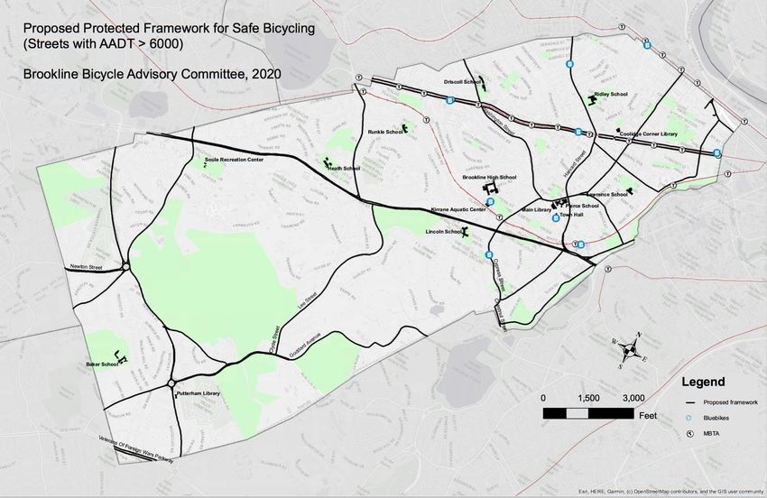
Contents
1. Vision for a Bicycle Friendly Community…………………………………………………...……………….3

2. Network Plan…………………………………………………………………………………………………..…….5

3. Steps to Achieving the Network Plan………………………………………………………………………..……..8

4. Micromobility……………………………………………………………………………………………………………….11

5. Major Destinations……………………………………………………………………………………..……..……….…13

6. Street List of Proposed Projects…………………………………………………………………………………..…16

7. Projects Approved/Awaiting Funding……………………..…………………………………………………….33

8. Projects Awaiting Construction or in Progress……………………………………………………………….33

9. Completed Projects………………………………………………………………………………………………..……..34

10. References…………………………………………………………………………………..………………………………37

Appendices

   Appendix A: Brookline’s Bicycle Friendly Community Report Card from the
           League of American Bicyclists..…………………………………………………….39

   Appendix B: NACTO Guidance for Inclusive Bicycle Designs….…………….41

   Appendix C: Roadway Treatments and Other Bicycle
          Accommodations………………………………………………………………..44

   Appendix D: Signage and Pavement Markings….…………………………….…….48

   Appendix E: Detailed Recommendations for Bicycle Accommodations (by
           Street) ….…………………………………………………………………………...……….50

                                                                             2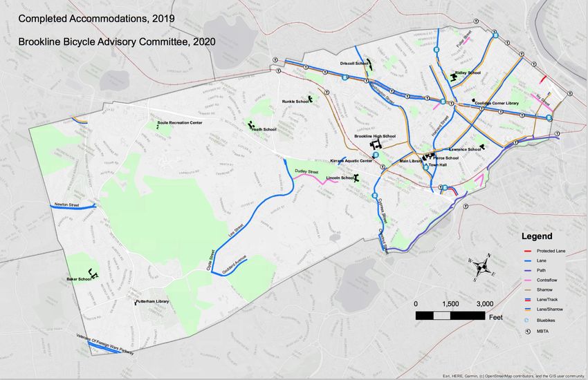
1. Vision for a Bicycle Friendly Brookline
Bicycling is a sustainable, economical, and
                                                            Definition of “Bicycles”
convenient mode of transportation for short and             The accommodations described
medium distance trips and is a popular form of              throughout this plan are designated for
recreation for young and old. Bicycling is good for         “bicycles,” but that term should be
the environment, for public health, and for reducing        broadly understood to include tricycles,
traffic congestion and parking demand. It offers            both recumbent and upright bicycles,
older children a measure of independence and is a           passenger and cargo cycles, electric-assist
                                                            cycles, and unicycles.
practical mode of travel to Brookline High School,
sports fields, and other local destinations.

Brookline already has many conditions conducive to bicycling – compact development,
proximity to major employment centers, relatively flat topography, and a temperate
climate. At 4% of commuter trips made by bicycle (US Census, 2010), Brookline’s
percentage has increased from 1.5% since 2000. Bicycle counts conducted during rush
hour on weekdays each fall since 2008 show more than 1,000 bicyclists per hour passing
major checkpoints, including more than 100 people riding daily to Brookline High School.
As many as 70 bicycles may be parked around Coolidge Corner at mid-day on September
Saturdays.

Beacon, Harvard, Washington, Carlton Streets, and Longwood Avenue are major connectors
for cyclists traveling to and from Brookline, parts of Boston, Cambridge, and Newton to
Kenmore Square, downtown Boston, the Longwood Medical Area, across Brookline, and
between Jamaica Plain and Brighton. The Emerald Necklace passes through Brookline, and
the Town has been and should continue to cooperate in making road crossings within the
Necklace safe for its users. Boston and Cambridge have made strong commitments to
improving conditions for cyclists and have made major strides in recent years toward this
goal. Brookline is centrally located to make a significant contribution to efforts to link
bicycle accommodations into a region-wide network through such on-going efforts as
“Landline: Metro Boston Greenway Network” of the Metropolitan Area Planning Council
and the “Emerald Network” plan of Livable Streets Alliance.

Brookline’s improvements in bicycle facilities and accommodations in recent years include
                                           more bike racks in commercial areas, additional
Definition of “Motor Vehicles”             bike lanes, shared lane markings on some high-
Because bicycles are technically           traffic streets, contraflow lanes, a buffered bike
considered vehicles, throughout this       lane on Beacon outbound from Marion Street to
document, we generally refer to motor      Washington Square, and institution of a $50 fine
vehicles to clarify their difference from  for motor vehicles blocking bike lanes. Brookline
bicycles. By motor vehicles, we mean       also actively participates in the regional
cars, trucks, buses and motorcycles--      “BlueBike” bike-share program.
generally vehicles that are larger, heavier
and faster moving (often much larger and      However, bicycle use in Brookline remains well
faster) than bicycles.                        below its potential and does not meet the
                                              criteria of the Complete Streets Policy, adopted in
                                                                                                          3
2016. For most residents, getting outside their immediate neighborhood requires
negotiating heavily trafficked streets, resulting in a level of stress and danger that many
people – especially less experienced cyclists – prefer to avoid. Every community with high
bicycle use, whether in the Netherlands, Denmark, Davis (CA), Portland (OR), or Boulder
(CO), offers an extensive network of bike routes with low traffic stress.

Brookline’s quiet local streets are ideal for bicycling, but they are not connected in a
network that facilitates cross-town travel, and some of these are increasingly threatened by
cut-through motor vehicle traffic. Many of the town’s dedicated bicycle facilities subject
cyclists to high traffic stress. The bicycle lanes on Beacon and Harvard Streets disappear at
intervals, leaving cyclists in heavy traffic, particularly at intersections. Bike lanes often
occupy the “door zone” of high turnover parking lanes and are seldom protected from
moving traffic. Double parking and curbside parking by motor vehicles are also problems
as they block bike lanes and force cyclists to stop abruptly or swerve into traffic. A 2017
study of bike lane violations showed that bike lanes on 18 segments of Harvard and Beacon
Streets were blocked by motor vehicles 27% of the time. Thus, even recent improvements
to bicycle facilities must be viewed as transitional; further improvements are needed to
make them truly safe and low stress.

As part of Brookline’s Climate Action Plan (CAP), the Select Board recommends prioritizing
planning to achieve zero emissions by 2050 Town-wide. The Climate Action Plan identified
five strategies to mitigate greenhouse gases, including “Improved Transportation Options.”
To this end, improving cycling infrastructure provides an opportunity for the Town to work
towards its zero emissions goal while also
providing residents a safe and healthy way to           Town Meeting passed WA 31
move around town.                                       (November 2019, 191-YES, 1-NO)
                                                       laying out the basis for and actions
                                                       toward making safer infrastructure for
Brookline’s favorable urban structure offers the       bicycles and other non-vehicular forms
potential to create a network of low traffic stress    of traffic. In part, it states:
and “green” bicycle routes. Other communities’         NOW, THEREFORE, BE IT RESOLVED
experiences suggest that Brookline can have up to      that Town Meeting calls upon the Town
10% of its trips being made by bicycle within a few    of Brookline to leverage its pre-existing
                                                       strengths, to: 1) Prioritize safe, space-
years. Young people will routinely cycle to school     efficient, and energy-efficient
and to athletic fields for games and practice.         movement of people and goods over
Residents will shop and run errands by bicycle,        the movement and parking of private
reducing motor vehicle traffic and parking             vehicles when designing and improving
demand. New greenways will better connect South        our public ways, with particular focus
                                                       on high-traffic routes, connectivity and
Brookline to the rest of town, a boon to walkers,      directness. This should be
joggers, and bicyclists alike. Families will enjoy     accomplished in a manner that gives
riding along Brookline’s green routes, with easy       particular consideration to equity of
access to the Town’s open spaces and to regional       access and safety for (i) people of a
off-road paths. More adults will bicycle to work       broad range of ages, abilities and
                                                       financial means, and (ii) use of
and to do errands, getting exercise and fresh air      healthful and sustainable
while saving money, enjoying their commute, and        transportation modes.
contributing to a sustainable environment. Safe

                                                                                                   4
routes to Green Line T stops, some of which have nearby BlueBike stations and many of
which have bike racks, could help to encourage combining cycling and transit use.

Creating this network of green routes requires deliberate planning, budgeting, and
refocused priorities. Some of the network can be created at minimal capital expense using
road markings and traffic management changes such as parking restrictions. Particularly
when changing parking, attention should be given to maintaining or increasing parking for
those with mobility limitations. Other parts of the network will require modest capital
improvements such as curb ramps and extensions. Some streets, notably in South
Brookline and along the town’s busiest thoroughfares, will require major new
infrastructure, possibly requiring state or federal funding.

This master plan should be complemented by other Town efforts to improve conditions for
cycling, including provisions for bicycle parking, safety education, traffic law enforcement,
and ensuring that every street project undertaken or permitted by the Department of
Public Works includes reasonable accommodation for bicyclists, pedestrians, and those
with mobility limitations. One particularly important effort is the Massachusetts Safe
Routes to School (SRTS) Program, designed to increase safe biking and walking for
elementary and middle school students by using a collaborative, community-focused
approach that bridges the gap between health and transportation.
(https://www.mass.gov/safe-routes-to-school) SRTS efforts are underway in Brookline.

The network evolution should be coordinated with regional plans including those for
Boston, Newton, and Cambridge to maximize its benefit to the entire region.

2. Network Plan

For the Town to plan and implement bicycle-related safety improvements, the Bicycle
Advisory Committee has designed a network of safe, pleasant, and connecting routes. The
network connects neighborhoods with important local destinations including schools,
libraries, parks, and commercial districts; it also connects to Green Line T stops and to
important bicycling routes at the Town limits, including Beacon Street in Boston and
Newton, Commonwealth Avenue, Perkins Street, West Roxbury Parkway, and the Charles
River off-road paths.

The major protected framework is comprised of routes that traverse the Town in all
directions. A second level of connecting streets provides access to and from these major
routes, to Town neighborhoods and key destinations such as schools and parks.
Recommendations for achieving a high-quality network, including the framework and the
connecting streets, are laid out in this section, and proposals for specific streets are
detailed in below. These are based generally on guidelines of the National Association of
City Transportation Officials (NACTO) as noted in the references and summarized in the
appendices.

                                                                                            5
Protected Framework
Projects that establish the framework of a safe cycling network throughout Brookline are
assigned the highest priority. Of necessity, this framework consists of the streets with the
highest motor traffic volumes, since Brookline’s road network lacks low-traffic, low-speed
alternatives for crossing town. This means that these projects call for treatments providing
physically separate greenways or protected bicycle lanes. Accordingly, we call this the
Protected Framework. The following list and map outline the proposed Protected
Framework, which consists of nearly all streets in town with Annual Average Daily Traffic
(AADT) in excess of 6,000 motor vehicles. In Section 6, the street list of proposed projects,
those that would help achieve the Protected Framework are marked with a caret (^).
Aspinwall Avenue Goddard Avenue Longwood Avenue
Beacon Street Grove Street Mountfort Street
Brookline Avenue Hammond Pond Parkway Newton Street
Carlton Street Hammond Street Route 9 (Boylston Street)
Chapel Street Harvard Street School Street
Chestnut Hill Avenue High Street St. Paul Street
Chestnut Street Horace James Circle Washington Street
Clyde Street Independence Drive West Roxbury Parkway
Cottage Street Lagrange Street
Cypress Street Lee Street
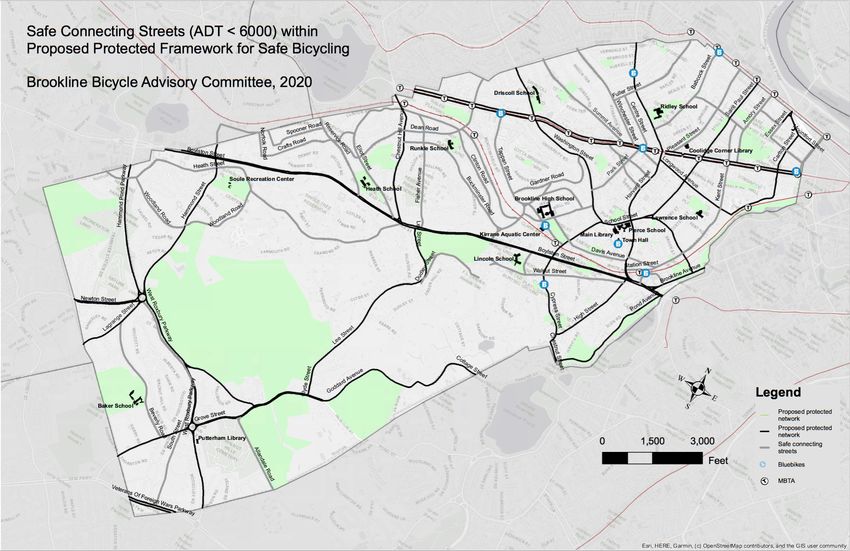
Safe Connecting Streets
6
The Protected Framework by itself does not provide safe access to and from all the Town’s
neighborhoods and key destinations such as schools, parks, and commercial areas. This
requires projects to make a set of connecting streets safe for cycling. These streets, which
usually carry a medium volume of motor traffic (3,000-6,000 AADT), should be retrofitted
with protected bike lanes. However, some streets are so narrow that protected lanes might
not be feasible. In such cases, they should be traffic-calmed to slow motor traffic to 20 mph
or less or converted to one-way streets so that a protected bike lane can be installed. The
following list identifies the proposed Safe Connecting Streets, and the map adds them to the
Protected Framework. In Section 6, the street list of proposed projects, those that would
implement Safe Connecting Streets are marked with a double caret (^^).
Allandale Road           Davis Avenue             Kent Street              South Street
Amory Street             Dean Road                Marion Street            Summit Avenue
Babcock Street           Dudley Street            Middlesex Road           Sumner Road
Beverly Road             Eliot Street             Norfolk Road             Tappan Street
Blake Road               Essex Street             Park Street              Vernon Street
Buckminster Road         Fisher Avenue            Pearl Street             Walnut Street
Centre Street            Freeman Street           Pleasant Street          Webster Street
Clark Road               Gardner Road             Powell Street            Winchester Street
Cleveland Road           Greenough Street         Reservoir Road           Woodland Road
Clinton Road             Heath Street             St. Mary’s Street
Corey Road               Ivy Street               Station Street
Crafts Road              Kennard Road             Somerset Road

                                                                                               7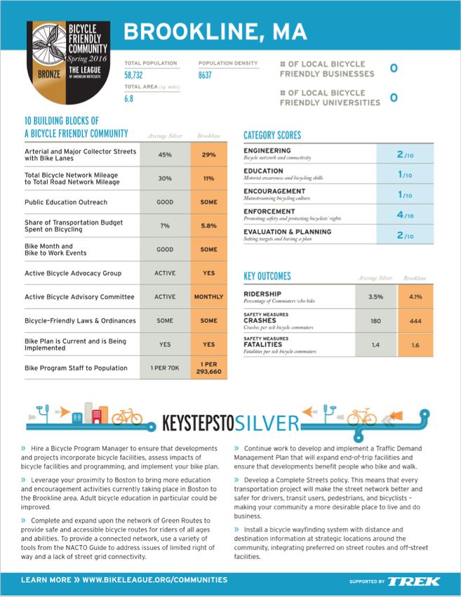
3. Steps to Achieving the Network Plan
Existing Bicycle Accommodations
The map below shows the current status of bicycle accommodations in Brookline,
and Section 9 lists completed projects that have contributed to this progress.
Despite these improvements, bicycling in Brookline is not safe and viable for
persons of all ages and abilities; thus, to help meet Brookline’s emissions goals and
complete streets standards, it is important to continue improving current bicycle
accommodations, especially on busy streets. For example, some bike lanes need to
be widened, buffered, or physically protected to reduce the perceived and real risk
of crashes such as dooring. Engineering standards for bicycle accommodations are
changing rapidly as indicated by the NACTO table in the appendices, and additional
improvements should be made to Brookline’s streets to reflect best practices.
Furthermore, the map below clearly indicates that existing accommodations do not
form a network.

Plan and Implement New Accommodations
As new bicycle accommodations are planned for and implemented, priority should
be given to the Protected Framework described above and to the following caveats:
    • Intersections are the most dangerous locations for all street users—
       pedestrians, cyclists and motorists—and the sites of many crashes and
       injuries. Therefore, special attention should be given to safe passage across

                                                                                        8
and through intersections for all users. This may require special traffic
        signals and/or pavement markings for crosswalks and bicycle crossings.
    •   All traffic signals should either be on a regular cycle that provides
        opportunities for all road users to cross in all directions OR sensors should
        be set in such a way so that a cyclist in the road can trigger them.
    •   Cyclists should be permitted to cross streets with advance pedestrian walk
        signs, as long as doing so does not endanger pedestrians.
    •   Streetlights should be adequate (and appropriately aimed) on all streets to
        make the right of way visible to pedestrians and cyclists.
    •   Changes such as bulb outs that force cyclists to temporarily merge with
        motor traffic should be avoided.

One way to test proposals for new bicycle accommodations is to set up temporary
trials to assess their value for and impact on all street users. Such pilot projects
might last for as little as a few days to as long as a year (as on Beacon Street
outbound from Marion to Westbourne Terrace). Many can be accomplished with
traffic cones, water-soluble paint, or other inexpensive and temporary materials and
can provide invaluable information on safety for cyclists, impact on pedestrians, and
effect on traffic flow.
Fill in the Gaps
                         Bicycle lanes that disappear at intersections or that start
                         and stop along a major road as they do on Harvard Street,
                         do not offer safe, continuous routes. Major gaps are
                         delineated in the street list and can be seen on the map of
                         existing accommodations, but it should be noted that there
                         are also gaps that need to be filled to knit together safe,
                         continuous bike routes. A few examples:

    •   Safe crossing of Netherlands Road between Parkway Road and the Muddy
         River Path
    •   Multiple interruptions of the bike lanes along the length of Harvard Street,
         where bike lanes repeatedly turn into shared bicycle/motor vehicle travel
         lanes
    •   Beacon Street outbound from Pleasant Street to Marion Street
    •   Washington Street, where bike lanes turn into shared bicycle/motor vehicle
         lanes, e.g., near and across the intersection with Beacon Street
    •   Beacon Street inbound from Webster Street to St. Mary’s Street

Replace and Maintain Bicycle Accommodations
Once put in place, bicycle accommodations on Brookline’s streets must be
adequately maintained. Whether in the form of painted lines, stencils, bollards,

                                                                                        9
curbs, or other means of providing safety for cyclists sharing roads with vehicular
traffic, it is essential that these accommodations be promptly replaced or
maintained when damaged or removed by road/construction projects or by regular
wear and tear. Monitoring of utility and other construction work should assure that
trenches or other pavement cuttings do not leave dangerous ridges in bike lanes. It
is also important that bike lanes be kept clear of overhanging vegetation, debris and
snow. Road surface conditions along heavily used streets/corridors that have
separate/protected bicycle lanes are of particular concern. Examples include nearly
all of Washington St. (pictured above) between the Boston town line at Whole Foods
and Brookline Village, St. Paul St., much of Harvard Street, and Chestnut Hill Ave.
between Rt. 9 and Beacon St. The bike lanes along these streets are characterized by
large cracks, major potholes, sewer dips, and other hazards. This is unpleasant at
best and life-threatening at worst. In some situations, bicyclists are forced out of the
lane into traffic in order to avoid a major hazard.

Historically, the default solution to this situation is to repair the bike lane in line
with the schedule of the repair of that road. However, the situation has become
increasingly dangerous on some critical roads, and the schedule for their repair
might be several years away in some instances. Need for bike lane repair should be
assessed to prioritize areas of greatest need.

                      An inventory of bicycle accommodations could (1) identify
                      streets, or portions of streets, in most urgent need of repair;
                      (2) assess the schedule for the repair of the overall street. If a
                      bike lane is in fair condition or worse and the schedule for that
                      street’s repair/resurfacing is two years away or more, then a
                      temporary repair of that bicycle lane should be undertaken,
                      such as aggressive patching, or a temporary resurfacing of the
                      bike lane. An example of such a bike lane resurfacing is shown
                      in the photo on Beacon St. in Newton, between Grant Ave. and
                      Hammond St.

A specific budget and priority list should be established each year for the repair of
bicycle lanes like the program for sidewalk repairs. A resolution was passed by
Town Meeting (November 2019) on maintaining existing street markings designed
for safety, including bicycle and pedestrian markings, but repair of dangerous
pavement should also be undertaken.

Brook-on-Line is an app for reporting problems that need to be addressed by
various Town Departments; new categories directly related to bicycle issues would
be useful.

                                                                                      10
Provide Wayfinding Signage
Wayfinding signage for cyclists provides information on
distances/directions to key locations and the optimal
cycling routes to those destinations. Besides guiding
cyclists, destination signs advertise the Town’s bike
routes, tourist sites, and commercial areas, promoting
bicycling and economic growth. An additional benefit of
wayfinding is that it increases awareness for automobile
drivers as well. When they see a cycle/wayfinding sign, it
indicates that this is a cycling route/corridor/bicycle
friendly road. See appendices for examples of wayfinding
signage and pavement markings.
We recommend three signage guidelines as part of the Green Routes Plan:
• Improved signage and wayfinding to destinations in Brookline (i.e. Coolidge
Corner), and commuting corridors (to downtown, medical area, river, etc.)
• Wayfinding should be destination oriented but also best route oriented (i.e.,
where there are bike lanes and markers)
• Signage should be large enough to be visible to cyclists and to drivers
4. Micromobility
Micromobility: Wikipedia defines micromobility as “a category of modes of
transport that are provided by very light vehicles such as electric scooters, electric
skateboards, shared bicycles and electric pedal assisted, pedelec, bicycles.” The
definition generally focuses on shared use (rental) bicycles and scooters, as a means
of travelling the “last mile,” e.g., from a train/transit stop to a destination in dense
urban areas. For the purposes of this plan, the definition is broader and
encompasses bicycles and stand-up scooters of all types with or without motor-
assist and whether privately owned or shared/rented, as well as motorized
wheelchairs and other modes for people with mobility limitations.
In 2016, transportation made up more than 40% of greenhouse gas emissions in
Massachusetts (https://www.mass.gov/service-details/ma-ghg-emission-trends).
In an effort to mitigate some of these emissions, there is a growing emphasis on
shifting away from single occupancy motor vehicles to new, lightweight, human- or
electrically powered means of transportation. Innovations in micromobility
technologies can be expected to continue. Many of these modes share
accommodations originally designed primarily for bicycles, hence their relevance to
this plan.
11Accommodating Micromobility Devices
Motorized micromobility devices generally run on
electric power as well as pushing/pedaling. Generally,
a small motor using rechargeable batteries allows
travel at up to 16-20 mph. In planning to safety
accommodate these micromobility devices the
following should be considered:
• Micromobility modes will increase the total number and variety of bicycles,
scooters, etc. of micromobility vehicles on the road.
• They will lead to an increased number of people using them, representing a
wider breadth of age groups, physical conditions, road awareness, and
experience.
• They will often use the same infrastructure as bicycles, both on the road and
for parking/locking, etc.
• They can travel substantially faster than most bicyclists, especially uphill.
• Eventually, there will also be a need for charging stations (possibly solar-
powered); these can be either standalone or combined with electric motor
vehicle (EV) charging stations.
Stand-up electric scooters are becoming prevalent in
cities around the world, operated similarly to dockless
bike share systems by companies such as Bird and Lime.
In some cities, the use of electric scooters is already
outpacing that of bicycles in shared systems.
Brookline ran an eight-month trial program of e-scooters
from April to November 2019; this included inviting e-
scooter share companies to community events to
introduce the micromobility device to residents and allow
test drives. The program generated about 200,000 trips--
an average of nearly 1,000 per day. More than 20,000
people used e-scooters. Approximately 20% of these scooter trips replaced short
motor vehicle trips (and, also, presumably, some bicycle trips and some walking).
Those who used the scooters were satisfied with their operation and as a form of
micromobility. There were relatively few reported injuries or accidents (fewer than
10 at the six-month mark). The success of the program shows the demand for
micromobility solutions and alternatives to motor vehicles.
However, there were some issues during the trial. The most significant
problem/complaint was scooter riders using sidewalks rather than roadways.
Pedestrians considered this unnerving and unsafe. The primary reason for e-scooter
users using sidewalks is that using the road was considered unsafe in those
situations--either because of the lack of a dedicated or protected lane, or because of
12dangerous road surface conditions. There were also complaints about inappropriate
parking of scooters.
Addressing the Demand for E-scooters
As has been demonstrated by their popularity in other locales as well as by
Brookline’s trial program, there is significant demand for e-scooters. They should be
considered as part of the bigger desire to find alternatives to motor vehicles as a
form of transportation, along with bikes and e-bikes. The demand for and popularity
of e-scooters places a greater imperative on the Town to accelerate plans to increase
the number of dedicated, and especially protected, bike lanes.
Brookline has been working with Boston, Cambridge, and the Metropolitan Area
Planning Council (MAPC) to develop both pilot programs and legislation to allow for
scooters’ legal use and regulation in Massachusetts.
5. Major Destinations
The purpose of a good bicycle network is to provide safe routes for cyclists of all
abilities to be able to reach major destinations. This section identifies some high
priorities within the context of aiming for a Protected Framework with Safe
Connecting Streets. Routes to schools, parks, business districts and other frequently
visited destinations that connect existing paths, bike lanes and quiet streets are
assigned a high priority. Completing bike routes on major streets that are heavily
used by commuting or shopping cyclists—such as Beacon Street, Harvard Street,
and Longwood Avenue—are also high priority. When reviewing projects on one
street, attention should be given to intersecting streets to ensure connectivity
within the network.
Note: For some of the destinations listed below, specific recommendations for safe
access have been made; for others, work is underway to identify access roads, many of
which are already listed as part of the Protected Framework or Safe Connecting
Streets.
Schools
In conjunction with Safe Routes to School programs and
to assure the safety of students, special consideration
should be given to pedestrian and bicycle safety in and
around all school grounds, particularly to separating
motor vehicle pick-up/drop-off areas from walking and
bicycle routes. With plans currently underway for
new/remodeled/expanded schools to accommodate
increased enrollment, it is important that plans for
new/remodeled schools include sidewalk
improvements, bicycle accommodations and safe pick-
up and drop-off areas to enhance the ability of students
13to walk or bike safely to schools. Suggestions for two current projects are provided
here as examples.
Driscoll School: Ideally, students would be able to approach Driscoll School from
every direction and enjoy safe sidewalks and protected, separated bike lanes on all
adjacent streets.
• Beacon Street westbound/Westbourne Terrace: Beacon Street currently has a
buffered bike lane. As cyclists take a right from Beacon Street onto Westbourne
Terrace, they would ideally merge onto a protected two-way cycle track adjacent
to the sidewalk on the left (west) side of Westbourne Terrace. Entrance to the
playground area and rear entrance of the building via a short flight of stairs could
be improved with a bicycle channel or ramp. Maintenance or expansion of bike
parking on the Westbourne Terrace side of the school would also allow students
convenient ingress via this route.
• Westbourne Terrace from north is a relatively narrow but quiet street that is
used by students from Corey Hill. From the intersection of Westbourne Terrace
and Bartlett Street, students should be able to either continue straight onto a
raised separated two way cycle track adjacent to the school to the Westbourne
Terrace entrance, or turn right onto a raised cycle track along the south side of
Bartlett Street and then turn left into the parking lot/rear entrance bike parking
area.
• Washington Street from south currently has a bike lane on the outside of
metered parking. Ideally this would be replaced by a raised cycle track adjacent
to the sidewalk, to allow students to either turn into a walkway (walking bikes)
adjacent to the playground, or into the parking lot. A bicycle channel on the
steps up to the bike racks on the upper level parking lot, or installation of more
bike parking on the lower level parking lot would allow students to access
parking.
• Washington Street from north currently has sharrows, and students can
approach the protected crosswalk with crossing guard at Salisbury Road and
Washington Street and enter into either lower parking lot or walk their bikes
along the walkway adjacent to playground to reach bike parking.
• Bartlett Street could have a raised contraflow option that would not put
students in conflict with cars.
• Other quiet streets leading to Driscoll can serve as important safe routes for
students on bikes (Bartlett Street, Bartlett Crescent, Salisbury Road).
Other schools: Routes to other schools should receive similar consideration,
including Baldwin (Heath Street), Baker (Beverly Street), Heath (Eliot Street),
Lawrence (Francis Street), Lincoln (Kennard Road), Pierce (School Street), Ridley
(Harvard Street), and Runkle (Druce Street)
Brookline High School (BHS) serves students, teachers, swimmers, ball players,
Town Meeting Members, and playground visitors. This renovation/construction in
14this area provides an opportunity to set the example in "prioritizing safe, space-
efficient, and energy-efficient movement of people and goods over the movement
and parking of private vehicles when designing and improving our public ways, with
particular focus on high-traffic routes, connectivity and directness." (Warrant
Article 31 Fall 2019 Town Meeting)
A treatment that would be far superior to the existing bicycle accommodations,
without requiring major changes to existing curbs, would provide for two-way bike
movements on the one-way streets in the vicinity of BHS. This could be done by
implementing protected contra-flow lanes, accompanied by sharrows in the with-
flow direction and designating all these streets as 20 mph safety zones. The design
would include the following features:
• Two-way bike path connecting Davis and Tappan between the Cypress ball fields
and playground
• Protected contra-flow lane next to Cypress Field on Greenough from Tappan to
Davis
• Protected contra-flow lane next to Cypress Field on Davis from Greenough to
Cypress
• Protected contra-flow lane next to Cypress Field on Tappan from Cypress to
Greenough
• Protected contra-flow lane on Tappan from Blake to Greenough
• Protected contra-flow lane on Sumner from Greenough to Blake with traffic flow
sharrow markings on the above-noted street segments
• Rear-angle parking on Tappan Street to replace the current head-in angle parking
A better and safer design would provide for protected bike lanes in both directions
on all streets in the above list, or possibly turning Greenough and Tappan along the
BHS campus buildings from Davis to Cypress into a pedestrian mall where cars,
while allowed, would be required to move at speeds under 15 mph.
Given that BHS serves the entire town, the streets in the envisioned Protected
Framework with Safe Connecting Streets that provide access to and from BHS
(especially Harvard, Park, Washington, Tappan, Cypress and Greenough) should be
high priority for improvement and maintenance.)
Brookline Town Center: Town Hall, the Public Safety Building, the Public Health
Building, and the Brookline Village Library are all located on or just off Washington
Street near Harvard Street and School Street, so improvements to those main
roads—part of the Protected Framework, will improve safe access to these
important public buildings.
15Commercial Areas: All of Brookline’s commercial areas are on or near major
streets that are part of the Protected Framework: Coolidge Corner (Beacon and
Harvard Streets), Brookline Village (Washington and Harvard Streets), Washington
Square (Washington and Beacon Streets), so the
priority improvements to those streets will facilitate Brookline Complete Streets Policy was
safe access via micromobility modes to these adopted by the Board of Selectmen in 2016
important commercial/cultural destinations. and states:
The Town of Brookline shall plan,
Parks, Conservation Areas, and Recreational construct, and maintain its public ways
Facilities are important destinations. Many are on to enhance safety, access, inclusion,
school grounds or adjacent to schools. Many are on convenience and comfort for all users,
streets already included in the Protected thereby creating “complete Streets.”
Framework and Safe Connecting Network. The Town will create a comprehensive
transportation network that
sufficiently accommodates people of all
6. Street List of Proposed Projects ages and abilities, whether traveling by
foot, bicycle, wheelchair, mass transit,
Bicyclists are entitled to use all streets in Brookline. or motor vehicle.
Whenever changes or improvements in roads are
…the Town’s transportation projects
planned, consideration should be given to bicycle and
shall be designed and implemented to
pedestrian safety in accordance with the “Brookline
provide safe and comfortable access for
Complete Streets Policy.”
healthful transportation choices such
as walking, bicycling, and mass transit.
Projects are listed below alphabetically by street name.
The needs and safety of the town’s
Asterisks (*) highlight projects and intersections that are
most vulnerable users shall be given
particularly important and/or dangerous as currently
special consideration during project
configured. These should have high priority for planning. Users may be considered
reconfiguration, repair, or other appropriate attention. vulnerable by virtue of their mode of
Single carets (^) mark projects that contribute to the transportation, such as bicycling or
proposed Protected Framework; double carets (^^) mark walking, or because of their age or
those that are safe connecting roads that are key to mobility.
completing the Green Routes Network.
Abbottsford Road: Abbottsford Road, Beals Street, Coolidge Street, Fuller Street, Kenwood
Street, Russell Street, Thorndike Street, and Verndale Street are all streets in the JFK
Crossing neighborhood that have portions that were at some point made one-way,
apparently to discourage cut-through traffic. These are all wide enough to provide buffered
or protected contra-flow lanes that would allow for easier and more direct bicycle
navigation and would have some traffic-calming effect.
^^Allandale Road: Allandale provides an important connection to Allandale Farm, to the
Arboretum, and other Boston locations. With its medium traffic volume (3514 AADT), it
needs protected bike lanes or it should be traffic-calmed to slow motor traffic to 20 mph or
less. Mark bike lanes in both directions between Grove Street and the Town Line; keep
brush cut back from sides of the road where it currently impedes on the existing shoulder.
At the Brookline/Boston line, the road narrows suddenly, and there should be warning
signs at a minimum. Preferably Brookline and Boston could work together to improve the
bicycling conditions toward the Arboretum in Boston.
16Alton Place between Harvard Street and St. Paul Street: Add a contra-flow bike lane.
^^Amory Street: Amory, with its medium traffic volume (3514 AADT), should be traffic-
calmed to slow motor traffic to 20mph or less.
^Aspinwall Avenue: Aspinwall provides an important connection between Harvard Street
and both St. Paul to the north and Brookline Avenue to the east. It has a high level of traffic
(10043 AADT), so protected bike lanes in both directions are necessary.
*Atherton Road: Add contraflow lane from Winchester Street to Summit Avenue to provide
a quiet, safe route to the buffered bike lane on Beacon Street (just beyond Summit), allowing
some cyclists to avoid the heavy traffic of Coolidge Corner.
^^Babcock Street: Because of its medium traffic volume (3555 AADT), Babcock Street
should be made more bicycle and pedestrian friendly for its entire length by providing
protected bike lanes in both directions, or else calming motor traffic to 20mph or less.
Babcock Street’s importance as a connector for bicycles will only grow in the future because
it will provide a direct route between Brookline and Commonwealth Avenue, the projected
MBTA West Station, and newly created parkland and bicycle paths along the Charles River
(all part of the I-90 Allston/West Station project).
Bartlett Street: Install contraflow lane from Washington Street to Westbourne Terrace on
south side of street, closest to school to improve access to Driscoll School. Consider safe
ways to access school grounds—perhaps with shared use paths around the school grounds
themselves and safe areas for bicycle parking. (Also see “Driscoll School” above)
^Beacon Street (Beacon Bridleway):
The possibility of reclaiming the former bridle
path in the center of Beacon Street along the C
line tracks as a two-way protected multi-modal
path should be actively pursued. The Bridle
Path, designed by the Olmsted firm, is shown as
the dark gray strip by the side of the train tracks
in the accompanying historical photo. (Collected
by Jules Milner-Brage, courtesy of the Archives
of American Gardens, Smithsonian Institution,
Washington, D.C.) This proposal would
significantly enhance the safety of a major route
through Brookline and would connect to bicycle
accommodations in the regional network at
Boston and Newton. The proposal is to reclaim
the Olmsted designed bridle path, on the wide
side of Beacon Street through the length of
Brookline to provide a two-way protected multi-
modal path with cross-overs at intersections
where the wide side of Beacon Street shifts from
one side of the MBTA tracks to the other
(Coolidge Corner and Washington Square). Plans
are being developed to accomplish this without
17much—if any—loss of parking or travel lanes. The contemporary photo shows how a ten+
foot wide two-way cycle track could be installed while maintaining angled parking.
*^Beacon Street outbound from Boston City line to Carlton Street, and further to
Harvard Street: Upgrade bicycle facilities to protect cyclists better from moving motor
vehicles and the door zone of parked cars by moving the bike lane between the curb and the
parking lane, as has been done in Boston just to the east of the Town line. The stretch from
St. Mary’s Street to Carlton Street is very high priority because it experiences the worst
incidence in Brookline of motor vehicles obstructing the bike lane and it can be
implemented inexpensively. The remaining stretch to Coolidge Corner is lower priority as
long as plans move forward to implement the Beacon Bridleway.
^Beacon Street inbound at Pleasant Street: See Pleasant Street.
^Beacon Street at Charles Street: Traffic signal for left/U-turn from Beacon Street
inbound to Beacon Street outbound or from Charles Street to turn left on Beacon should be
triggered by a bicycle.
*^Beacon Street outbound from Pleasant to Marion Street: Design safe passage for
bicycles from the end of the Beacon Street bike lane to start of bike lane at Marion Street.
^Beacon Street at Marion Street: Traffic signal for left turn from Beacon onto Marion
should be triggered by bicycle.
Beacon Street outbound from Westbourne Terrace to Washington Square: Improve
transition from the end of the bike lane near Westbourne Terrace to Washington Street
intersection. Increasingly important due to planned renovation of Driscoll School.
^Beacon Street Morning Rush Hour Bicycle Lane (inbound) via parking restrictions on
sections of Beacon Street inbound where parking is allowed and there is no bike lane. Time-
limited restrictions during the morning commuting period would effectively create a 7'
wide bicycle lane to the right of the two lanes of motor vehicle traffic, thereby increasing
safety and throughput for both cyclists and motorists.
Beals Street: See Abbottsford Road.
^^Beverly Road: Beverly Road provides access to and from Baker School. With its medium
traffic volume (3549 AADT), it should either have protected bike lanes or be traffic-calmed
to 20mph or less. Additional safety measures, such as wider crosswalks at the Baker School
grounds should be considered to improve safety during the busy times of school opening
and closing.
Bicycle Racks: Additional bicycle racks are requested for Town Hall, particularly under the
parking lot side of the overhang outside the entrance to provide some protection from
weather; at some public schools; lower Beacon Street between Carlton and St. Mary’s
Streets on the inbound side of Beacon Street; Cypress/School/Washington business area; at
parks throughout town that have few if any bicycle parking racks. Specific requests have
been made for Gibbs Street between Beals Street and Naples Road.
18^^Blake Road: Blake Road provides access to and from Brookline High School. With its
medium traffic volume (3632 AADT), it should either have protected bike lanes or be traffic-
calmed to 20mph or less.
^Brookline Avenue: Bike lanes between Town line and Washington Street (Route 9) would
continue lanes and sharrows already installed by Boston through the Longwood Medical
Area and provide an important connection to the Emerald Necklace paths and Brookline
Village. However, given Brookline Avenue’s high traffic level (19524 AADT), protected bike
lanes are needed.
*Brookline Avenue crossing for Emerald Necklace/Muddy River Path at Parkway Road
requires new signals, signal synchronization, curb extension, and curb ramps. The Muddy
River Path is an attractive greenway for cyclists traveling between the Landmark Center
and Jamaica Pond. Brookline Avenue bisects the path, and it is difficult to cross this four-
lane road due to heavy traffic, physical barriers, and the lack of a dedicated crossing. This
project requires a traffic signal installed at the intersection of Brookline Avenue and
Parkway Road with a sequence tied to the signal at the corner of Aspinwall Avenue and
Brookline Avenue. This would allow for to safely cross between Parkway Road (with its
contraflow lane) and the Emerald Necklace. Additionally, a curb extension and ramps are
necessary to allow bicycles to safely queue on the southeast side of Brookline Ave and to
ascend onto the greenway. (In 2011, Brookline received a grant to proceed with planning of
this and other connections for the Emerald Necklace.)
^^Buckminster Road: Buckminster Road, Clark Road and Clinton Road connect residential
areas with Boylston Street, Chestnut Hill Avenue and Beacon Street corridors, and with
Runkle School and Brookline High School. With their medium traffic volumes (3600+
AADT), they should either have protected bike lanes and/or be traffic-calmed to 20 mph or
less.
^Carlton Street: Together with Longwood Avenue, and Chapel, Ivy and Essex Streets,
Carlton Street provides an important link in both directions between the BU Bridge and the
Longwood Medical Area, as well as a link to the soon-to-be-restored Carlton Street
Footbridge. With its high traffic volume (9619 AADT) it should have protected bike lanes in
both directions.
^^Centre Street: Install flex posts to prevent parking in the bike lane; paint bike
lane markers in the lane.
^Chapel Street: Together with Longwood Avenue, and Carlton, Ivy and Essex Streets,
Chapel Street provides an important link in both directions between the BU Bridge and the
Longwood Medical Area, as well as a link to the soon-to-be-restored Carlton Street
Footbridge. With its high traffic volume (9605 AADT) it should have protected bike lanes in
both directions.
Charles Street: Install a contraflow lane for cyclists southbound beyond the garage
entrance to Sewall Avenue; then a contraflow lane on Sewall Avenue to Longwood Avenue
to provide safe access to the rear of businesses.
19^Chestnut Hill Avenue between Route 9 and Beacon Street at Cleveland Circle:
Chestnut Hill Avenue is a major route from South Brookline (extending the bike lanes on
Lee/Clyde Streets) to Dean Road, Clinton Road, and Beacon Street at Cleveland Circle. It is a
high traffic street (17007 AADT) and needs protected bike lanes in both directions. It is
approximately 38 feet wide from Boylston Street (Rt 9) to Clinton Road. In this area, car
travel lanes should be reduced to 10 feet wide to help reduce car speeds to the posted speed
limit of 25 mph. The rest of the lane width can be split evenly on both sides for protected
bike lanes. From Clinton Road to Beacon Street, bike lanes should be continued with the car
lane width being reduced and the buffered area being reduced or removed as necessary. In
order to accommodate the bike lane, the additional northward car travel lane should not be
provided until the entrance to the MBTA depot is reached since this is where the road
widens. Finally, paint that directs bikes to cross the tracks in the safest way should be
added.
^Chestnut Hill Avenue at Clinton is a difficult crossing for cyclists and pedestrians, with
poor sight lines. A median refuge is recommended to allow crossing half of Chestnut Hill
Avenue at a time.
^Chestnut Hill Commercial District: This project helps to make the Chestnut Hill
shopping area safer and more accessible for bicyclists. It takes advantage of the relative
safety of both Middlesex Road on the north side of Route 9 and Heath Street on the south.
The project involves creating bike lanes on Hammond Street from Middlesex Road to the
shopping center and then extending a bike path through the shopping center connecting to
the traffic light at Tully Street, thence to Heath Street and to and from Hammond Pond
Parkway. Some of the bike path would be built as a sidewalk extension. Coordination with
the City of Newton is essential. An additional accommodation could be to re-stripe the
Hammond Street/Route 9 intersection to make it safer for bicyclists to go from Middlesex,
across Route 9 to a right turn on Heath Street.
^Chestnut Street: Portions of Chestnut Street are very high traffic (15909 AADT) while
other portions are moderate traffic (3735 AADT). The high traffic section that connects
Cypress and High Streets to Pond Avenue, Leverett Pond Path and Jamaica Plain at Paul
Pender Rotary (aka Riverdale Parkway Rotary) needs protected bike lanes.
^^Clark Road: See Buckminster Road.
^^Cleveland Road: This short road is an important connection between Eliot Street and
Reservoir Road; it may not need special accommodations since it is a low traffic volume
street.
^^Clinton Road: See Buckminster Road.
^Clyde Street: See Lee/Clyde.
Coolidge Corner: This is a major crossroads and commercial area for Brookline and should
be made safe for all users. See comments for Beacon and Harvard Streets for specific
recommendations.
Coolidge Street: See Abbottsford Road.
20^^Corey Road: Corey Road provides an important connection between Beacon Street and
Dean Road in the south, and Washington Street. With its medium traffic volume (3952
AADT) and narrow width, it should have sharrows and be traffic-calmed to 20mph or less
so that cyclists can ride safely mixed with motor traffic. Half this stretch of Corey is in
Boston and half is in Brookline, so the treatment should be coordinated with the City of
Boston.
^Cottage Road from Goddard Avenue to Warren Street: Bike lane or traffic calmed to 20
mph to ease uphill travel for bicyclists. For section of Cottage Road that merges with
Goddard, see treatment for Goddard.
^^Crafts Road: Crafts Road, along with Middlesex Road and Dean Road, connects
Hammond and Boylston Streets in South Brookline with Cleveland Circle, Washington
Square and other parts of North Brookline. With its medium traffic volume (3630 AADT)
and narrow width, it should have sharrows and be traffic calmed to 20mph or less.
^Cypress Street from High Street near the Jamaica Plain border to Washington Street:
Cypress Street provides an important connection from south of Route 9 to Brookline High
School and, along with School Street, to all points north and east. Because it has a high
volume of traffic (10043 AADT), it should have protected bike lanes in both directions.
^Cypress Street (near Washington Street, CVS): Improve southbound approach to
Washington Street.
See appendices.
^^Davis Avenue at Cypress Street: Traffic signal should be triggered by cyclists waiting to
cross Cypress Street.
^^ Davis Avenue: Install contra-flow bike lane from Greenough Street to Cypress
Street to increase safety for cyclists egressing from the High School. Sharrows
should be provided in the direction of traffic. From Cypress Street to Washington
Street, if a protected bike lane can be provided in only one direction, traffic should
be calmed and sharrows provided in the other direction so that cyclists can ride in
the traffic lane.
^^Dean Road: Dean Road provides an important connection between Beacon
Street and routes to the Runkle School and the High School. With Crafts Road and
Middlesex Road it also connects Hammond and Boylston Streets in South Brookline
with Cleveland Circle, Washington Square and other parts of North Brookline. With
its medium traffic volume (3630 AADT), it should have protected bike lanes. If a
protected bike lane can be provided in only one direction, traffic should be calmed
and sharrows provided in the other direction so that cyclists can ride in the traffic
lane.
^^Dudley Street: With its contra-flow lane between Lee and Warren, Dudley Street
(along with Walnut Street) provides a two-way alternative to Boylston Street
21between Brookline Village and Lee Street. Because of its narrow width it should
have sharrows and be traffic-calmed to 20mph or less so that cyclists can safely
travel in the motor vehicle lane.
Dummer Street: As 24 feet wide that drops then rises gently in the westbound
direction. Westbound it carries heavy rush hour traffic from the BU Bridge into
North Brookline, and eastbound it carries traffic to the BU Bridge and
Commonwealth Avenue, so bike accommodations would be beneficial. The most
heavily trafficked section is between Essex and Amory, where a bike lane
westbound and sharrows eastbound should be possible. The same treatment might
be possible between Amory and St Paul, although there are some loading docks
perpendicular to traffic flow that might frequently block the westbound bike lane.
Between St Paul and Pleasant, bike treatments would be difficult because the street
primarily serves as a parking lot, with parallel parking for the BHA in the eastbound
direction and commercial parking westbound.
Dwight Street is Y shaped; on the stem of the Y, Dwight has parking on the north
side and is about 24 feet wide. The arms of the Y are about 20 feet wide--one arm
has parking south side (one travel lane going east) and the other on the north side
(one travel lane going west). There is two-way traffic on the stem. Add sharrows for
the length of the street.
^^Eliot Street: With its medium traffic volume (3630 AADT), protected bike lanes
are recommended on Eliot Street. If a protected bike lane can be provided in only
one direction, traffic should be calmed to 20mph or less and marked with sharrows
in the other direction so that cyclists can ride safely in the traffic lane.
^^Essex Street: Together with Longwood Avenue, Chapel, Carlton and Ivy Streets,
Essex Street provides an important link in both directions between the BU Bridge
and the Longwood Medical Area, as well as a link to the soon-to-be-restored Carlton
Street Footbridge. With its low traffic volume, protected bike lanes are not needed,
but because of its importance as a through route, it should have bike lanes in both
directions and be traffic-calmed to 20mph or less.
^^Fisher Avenue: With its medium traffic volume (3610 AADT), protected bike
lanes on Fisher Avenue are recommended.
^^Freeman Street: Along with Babcock, Powell and Kent, Freeman Street connects
residential areas north of Beacon with destinations south of Beacon. With its
medium traffic volume (3530 AADT) it should either have protected bike lanes or be
traffic-calmed to 20mph or less. Improve design of intersection with Babcock Street
to slow vehicular turns. One possibility is to reconfigure and enlarge the small park
to make one T-intersection of Freeman with Babcock rather than the two current
intersections on either side of the park. Implement traffic calming to discourage cars
from speeding to beat the traffic lights at Pleasant and St Paul Streets or change the
22You can also read