COMMERCIAL STREET OPERATIONS & MASTER PLAN - City of Portland, Maine
←
→
Page content transcription
If your browser does not render page correctly, please read the page content below
COMMERCIAL STREET
       OPERATIONS &
        MASTER PLAN
               JANUARY 2021
CITY OF PORTLAND
In partnership with:
Maine DOT
Casco Bay Lines
METRO
PACTS
Commercial Street Operations and Master Plan
                                                                                                                                   Introduction

                                                                         Project Purpose
INTRODUCTION                                                             The purpose of the Commercial Street Operations and Master Plan
Commercial Street, located along Portland’s waterfront, is an iconic     is to develop a vision for Commercial Street and specific
multi-functional ‘main street.’ It serves the City’s working             recommendations that improve the street’s safety, efficiency, and
waterfront, office, retail, and restaurant industries, and hundreds of   appeal for all users, including local residents, the fishing and marine
thousands of annual visitors. The street’s diverse mix of land uses      community, businesses and employees, as well as tourists and
and its variety of users contribute to both its vibrancy and its         visitors.
transportation challenges.                                               Throughout the project, the City and its project team have
                                                                         coordinated with partners and stakeholders that include the
The City of Portland recognizes Commercial Street’s complexity and
initiated the Commercial Street Operations and Master Plan to            Portland Area Comprehensive Transportation System (PACTS),
ensure that future design and policy decisions affecting the street      Maine Department of Transportation (MaineDOT), Greater Portland
reinforce the city’s broader goal in this area: supporting Portland’s    METRO (METRO), Casco Bay Island Transit District (CBITD or Casco
working waterfront and other economic engines operating along            Bay Lines), a Technical Advisory Group, the working waterfront
Commercial Street while promoting accessibility for all street users.    group, and members of the public.

                                                                         Study Area
                                                                         The project study area extends along Commercial Street from Beach
                                                                         Street to India Street. Short segments of adjacent or parallel streets
                                                                         were evaluated as needed based on the analysis and study area.
                                                                         The Commercial Street study area is shown in Figure ii.

                                                                         The study area includes a diverse mix of land uses as a result of the
                                                                         convergence of Portland’s downtown and working waterfront,
                                                                         including an active marine port; established and newly developed
                                                                         office space; restaurants, hotels, and retail catering to local
                                                                         residents and tourists alike; and residential.

Figure i: Vibrant Activity Along Commercial Street

                                                                                                                                                   i
Commercial Street Operations and Master Plan
Introduction

The Study Process
                                 Alternatives
      Existing     Issues &
                                 Development    Recommendations   Implementation
     Conditions   Oportunities
                                 & Evaluation

The study began with an extensive data collection phase and
culminated in a robust set of operational and infrastructure
strategies. The elements of the study include:
        •     Existing Conditions analysis (Chapter 1), including
              significant data collection, trends analysis, and public
              and stakeholder outreach.
        •     Issues and Opportunities analysis (Chapter 2).
        •     Alternatives Development and Evaluation (Chapter 3),
              where potential strategies were examined for their
              effectiveness in meeting project goals.
        •     Recommendations (Chapter 4), where the most viable
              strategies were organized into the themes of Smart
              City, Great Street, and Thriving Waterfront.
        •     Implementation (Chapter 5), where long-term and
              immediate next steps were identified.

                                                                                   Figure ii: Project Study Area Commercial Street: Beach
                                                                                   Street to India Street

ii
Commercial Street Operations and Master Plan
                                                                                                                                               Existing Conditions

                                                                               •                 Total weekday peak-season vehicular traffic volumes are
                             Alternatives
  Existing
 Conditions
               Issues &
              Oportunities
                             Development    Recommendations   Implementation                     fairly constant along Commercial Street throughout the day
                             & Evaluation
                                                                                                 (Figure 1-2), with high levels of demand but relatively
                                                                                                 modest demand peaks.
1. EXISTING CONDITIONS                                                         •                 Saturday peak-season vehicular volumes peak at around
The study included an in-depth analysis of existing conditions on the                            noon and remain nearly constant through approximately
Commercial Street corridor, covering the following areas and tasks:                              5:00 PM. Weekend volumes decrease less rapidly in the
                                                                                                 evening than do weekday volumes, likely due to the
    •     Traffic data collection, including pedestrian and vehicular
                                                                                                 adjacent restaurant and nightlife activity.
          count data and signal timing
                                                                               •                 Pedestrian counts along Commercial Street indicate that
    •     Field and site observations, including traffic operations,
                                                                                                 pedestrian volumes are nearly 10 times higher during the
          pedestrian movements, and freight and delivery
                                                                                                 peak season than during off-season periods. Pedestrian
          observations
                                                                                                 counts show that volumes are highest from Franklin Street
    •     Analysis of safety data, including high crash locations and
                                                                                                 to Union Street, but decline further west on Commercial
          bicycle and pedestrian crash locations
                                                                                                 Street.
    •     Evaluation of multi-modal operations data, including:
              o Bicyclist activity
                                                                                                       900
              o Cruise ship activity and passenger loads
                                                                                                       800
              o Local transit and trolley routes
                                                                                                       700
    •     Review of parking data and recommendations from the

                                                                                   Vehicular Volumes
                                                                                                       600
          2016 Parking Study for Downtown, the Old Port, and the
                                                                                                       500
          Eastern Waterfront
                                                                                                       400
    •     Analysis of intersection operations
                                                                                                       300
    •     Feedback from public and stakeholder meetings
                                                                                                       200
                                                                                                       100
Findings                                                                                                0
                                                                                                             Weekday PM Peak Hour       Saturday Midday Peak Hour
Traffic & Pedestrian Volumes
                                                                                                                   Peak Season      Off Peak Season
    •     Peak-season weekday and weekend vehicular traffic
          volumes were observed to be 25% to 30% higher than off-              Figure 1-1: Peak vs. Off-Peak Season Traffic Volumes
                                                                               (Bi-Directional, Measured East of Pearl Street)
          peak season traffic volumes (Figure 1-1).

                                                                                                                                                                    1-1
Commercial Street Operations and Master Plan
Existing Conditions

                 1000
                                  Eastbound           Westbound           Total
                 900

                 800

                 700
HOURLY VOLUMES

                 600

                 500

                 400

                 300

                 200

                 100

                   0
                        12:00 1:00 2:00 3:00 4:00 5:00 6:00 7:00 8:00 9:00 10:00 11:00 12:00 1:00 2:00 3:00 4:00 5:00 6:00 7:00 8:00 9:00 10:00 11:00
                         AM AM AM AM AM AM AM AM AM AM AM AM PM PM PM PM PM PM PM PM PM PM PM PM
Figure 1-2: Thursday, August 23, 2018 Hourly Vehicular Traffic Volumes: Commercial Street west of Market Street

1-2
Commercial Street Operations and Master Plan
                                                                                                                       Existing Conditions

Safety
High crash locations (HCLs) were identified based on MaineDOT
data (Table 1-1 and Figure 1-3). HCLs by definition have eight or
more crashes within a 3-year period and a critical rate factor higher
than one.

    •    High crash intersections include the two Commercial Street
         intersections with High Street and Park Street
    •    High crash segments include Commercial Street between:
           o Casco Bay Bridge and Maple Street
           o Union Wharf and Chandler’s Wharf
           o Custom House Street and Franklin Street.

Of these segments, Custom House Street to Franklin Street had the
highest crash rate.
Table 1-1: High Crash Locations: Critical Rate Factors &
Number of Crashes

                                  2013-2015           2014-2016
                                  Critical            Critical
             Segment Intersection Rate Factor         Rate Factor
  Harborview Park
                                      1.34 (9)        1.75 (11)
      to Maple St

   Union Wharf to
                                      1.81 (10)       2.21 (12)
 Chandler’s Wharf

  Custom House St
                                      3.42 (17)       3.96 (20)
   to Franklin St

                            Park St 2.44 (20)         2.14 (17)
                                                                        Figure 1-3: High Crash Locations (Maine DOT Office of
                            High St 1.49 (10)         1.71 (11)         Safety)

                                                                                                                                      1-3
Commercial Street Operations and Master Plan
Existing Conditions

Bicycle and pedestrian crash data were also assessed. These crashes   Signal Timing Data & Intersection Operations
were most prevalent east of Center Street and were concentrated       Intersection operations were observed at each of the signalized
near Market and Moulton Streets, as shown in Figure 1-4.              intersections within the study area (Commercial Street at Beach
                                                                      Street, Center Street, Union Street, and Franklin Street) in order to
                                                                      observe vehicle patterns and determine traffic signal timing
                                                                      information.

                                                                          •   Signal phasing and timing patterns were recorded at each
                                                                              intersection, with a focus on pedestrian signal phasing at
                                                                              each intersection. The Franklin and Beach Street
                                                                              intersections have concurrent pedestrian phasing, Union
                                                                              Street has concurrent pedestrian phasing with a Leading
                                                                              Pedestrian Interval (LPI), and Center Street has an exclusive
                                                                              pedestrian phase. Exclusive phasing means all intersection
                                                                              traffic is stopped during the pedestrian crossing phase; for
                                                                              concurrent phasing, the pedestrian crossing phases occur
                                                                              parallel with the direction of moving traffic.
                                                                          •   Intersection operations were modeled using Synchro, a
                                                                              standard industry intersection analysis tool. The results of
                                                                              the analysis are included in Table 2. This analysis indicates
                                                                              that all signalized intersections within the study area
                                                                              operate with a level of service (LOS) “D” or better, except
                                                                              for the Beach Street intersection during the Weekday PM
                                                                              peak hour and Franklin Street during the peak season
                                                                              Saturday midday peak hour, which both operate at LOS E.

Figure 1-4: 2010-2015 Bicycle & Pedestrian Crashes

1-4
Commercial Street Operations and Master Plan
                                                                                                                             Existing Conditions

 Table 1-2: Intersection Operations Analysis Delays and                           onto or crossing Commercial Street, resulting in a gridlock
 Corresponding Level of Service (LOS)                                             or failing condition
                                                                              •   Heavy eastbound queues at Beach Street turning left
                                Peak
                                Season
                                          Peak
                                          Season
                                                   Off
                                                   Season
                                                             Off
                                                             Season
                                                                                  against the heavy westbound traffic
  Commercial St.                Weekday   Sat.     Weekday   Sat.             •   Frequent vehicle stoppages, due in part to the lack of signal
    Intersection                PM        Midday   PM        Midday
                                                                                  coordination between the Franklin Street, Union Street, and
    Beach Street                70 (E)    30 (C)   32 (C)    16 (B)
                                                                                  Center Street intersections
    Center Street               23 (C)    10 (B)   18 (B)     8 (A)
                                                                              •   Malfunctioning traffic signal detectors were observed that
     Union Street               17 (B)     7 (A)   14 (B)     7 (A)               inhibited intersections from operating correctly
            Franklin
                                47 (D)    62 (E)   20 (C)    25 (C)           •   Slow travel speeds due to the relatively high numbers of
              Street
Delays in seconds per vehicle                                                     crosswalks, parking maneuvers, and truck backing
                                                                                  movements.
It should be noted that the traffic analysis results shown in Table 1-2
are based on the traffic volumes and signal timing data that the
project team collected; they illustrate how the intersections operate     Cruise Ship & Casco Bay Ferry Service
on a volume to capacity basis. However, traffic analysis                  Casco Bay Lines (CBL) Ferry service is directly served by Commercial
methodologies and Synchro both lack the ability to fully capture the      Street. CBL provides year-round service from the mainland to the
impacts of such things as the friction generated by parking, pick-up      Casco Bay islands. Historically, cruise ships have also docked along
and drop-off activity, center-turn lane and curbside deliveries,          the Eastern Waterfront east of India Street between spring and fall.
frequent pedestrian crossings, tour operators, and special vehicles.          •   Ferry service is provided to eight islands and also includes
Together, the volumes and intersection capacity combined with the                 specialty cruises. Figure 1-5 illustrates ferry departures by
existing signal timing, curbside friction, and unique operations                  time of day during 2018 summer weekdays. For typical
produce the following specific congestion issues:                                 years, ferry ridership peaks during July and August with over
     •     Long westbound queues at the Commercial Street at Beach                200,000 riders each month, with shoulder season peaks in
           Street intersection that extend east as far east as Union              September and October (CBL, Ridership Data, 2016/2017).
           Street during the afternoon peak hour. The long queues             •   Based on 2018 cruise ship season activity, cruise ship
           impede travel along Commercial Street and also create                  passenger volumes peak in September, with a total of 1,850
           obstacles that prevent vehicles on side-streets from turning           average daily passengers (Table 1-3). Peak cruise ship
                                                                                  passenger volumes are in September and October.

                                                                                                                                            1-5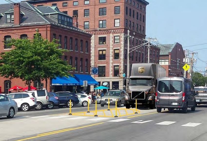
Commercial Street Operations and Master Plan
Existing Conditions
Table 1-3: Scheduled Cruise Ship Passenger Volume by
Month, April - October, 2018
Transit
Average Passengers A portion of Commercial Street is served by Greater Portland
Month Total Passengers Per Day METRO transit service and nearby South Portland Bus Service
April 2,689 448 (SPBS). Both providers’ service maps were reviewed to document
May 3,274 106 the location and frequency of proximate transit service.
Metro’s Route 8, which serves Downtown Portland and the
June 16,736 558
•
July 9,171 296 Portland Peninsula, runs along Commercial Street for one
August 14,921 481 block between Franklin and India Streets with a stop at the
September 55,690 1,856 Casco Bay Lines. From this route, passengers can transfer to
other Greater Portland bus routes at the Monument Square
October 48,054 1,550
Source: City of Portland
and METRO Pulse transfer centers.
• SPBS Routes 21, 24A, and 24B serve South Portland and run
10
parallel to Commercial Street along York Street from Union
9
Street to the Casco Bay Bridge.
8
DEPARTURES TO ISLANDS BY HOUR
• Several tour and trolley services also operate from
7 Commercial Street, principally opposite the Moulton Street
6 intersection, with tour times and schedules varying by
5 month and season.
4
Parking Capacity & Demand
3
Commercial Street currently provides parking along both sides for
2
much of its extent, and parking demand – especially during peak
1
season – impacts congestion. Portland’s 2016 Parking Study for
0
5:00 6:00 7:00 8:00 9:00
10:0 11:0 12:0
1:00 2:00 3:00 4:00 5:00 6:00 7:00 8:00 9:00
10:0 11:0 Downtown, the Old Port, and the Eastern Waterfront was reviewed
0 0 0 0 0
AM AM AM AM AM
AM AM PM
PM PM PM PM PM PM PM PM PM
PM PM to understand how on-street and off-street parking demand varies
Weekday Total 8 1 7 0 1 8 5 1 5 5 5 3 7 0 5 1 5 2 1
along the Commercial Street corridor. Data for the study was
Figure 1-5: Casco Bay Lines Summer Weekday Island Ferry
collected in the off-peak season and conditions were projected for
Departures by Hour (2019 Schedule) the summer peak.
1-6Commercial Street Operations and Master Plan
Existing Conditions
Findings include:
• The total effective capacity (defined as 90% of the total off-
street parking supply and 85% of on-street parking supply)
was 5,994 parking spaces along and within close proximity
to Commercial Street (Figure 1-8).
• The study found that for the entire study area, peak
summer season weekday parking demand was projected to
peak at noon, when parking demand was projected to
exceed effective capacity by 6%. Peak season Saturday
parking demand was projected to peak at 2:00 PM, when
total demand in the area was projected at approximately 70
% of the area’s effective capacity. The study includes finely-
Figure 1-6: Commercial Street Thursday December 1, 2016
grained parking supply and demand data, and notes when On Street Parking Occupancy (2016 Parking Study for
and where parking capacity and pricing could be better Downtown, the Old Port, and the Eastern Waterfront)
aligned, particularly between surface and structured
parking during peak-season weekends.
• Specific parking surveys were also conducted on
Commercial Street. The study indicated that on a typical
Thursday, on-street parking demand does not consistently
surpass capacity until 4:00 PM (Figure 1-6), after which on-
street demand exceeds supply until at least 9:00 PM. )
However, on Saturdays, Commercial Street on-street
parking demand exceeds supply from as early as 1:00 PM,
continuing through 9:00 PM (Figure 1-7).
Figure 1-7: Saturday 6 PM On-Street Parking Turnover
(2016 Parking Study for Downtown, the Old Port, and the
Eastern Waterfront)
1-7Commercial Street Operations and Master Plan Existing Conditions Figure 1-8: Old Port Parking Inventory (2016 Parking Study for Downtown, the Old Port, and the Eastern Waterfront, highlighted areas indicate within the study area) 1-8
Commercial Street Operations and Master Plan
                                                                                                                             Existing Conditions

Bicyclist Activity                                                           The data indicates that Commercial Street is one of the five
Bicycling activity data from Strava, a mobile application used by            corridors with highest bicycle ridership of cyclists using Strava in
cyclists and runners, was used to identify streets within the study          greater Portland. Based on the data, cyclist volumes increase
area with the highest bike ridership.                                        along and crossing Commercial Street as one moves from west
                                                                             to east (Figure 1-9).

                     3,500

                     3,000

                     2,500
  Total 2016 Rides

                     2,000
                                                      Total Rides     Commute Trips
                     1,500

                     1,000

                      500

                        0

Figure 1-9: Strava Ride & Commute Cyclist Data: Commercial Street, Beach St - Franklin St

                                                                                                                                              1-9
Commercial Street Operations and Master Plan
Existing Conditions
Field Observations o Trucks staging along the “truck apron” near the
The project team conducted field observations on Commercial Casco Bay Bridge, limiting potential employee and
Street during five site visits, two of which were during the peak- customer parking.
season. Findings from these observations are provided below. • Both photo documentation of the study area and drone
footage collected in August 2018 provided additional
• Vehicular operations, queuing, maneuverability, and signal perspective of congestion and friction along Commercial
timing operations: Street, as shown in Figures 1-10 and 1-11.
o The long westbound afternoon queues at Beach
Street
o High levels of “friction” and localized congestion
from pedestrians crossing Commercial Street,
delivery and tour bus operations, and large vehicles
o Inefficient vehicle operations at the Franklin Street
intersection due to its skewed alignment and width
• Pedestrian flows and effective sidewalk widths:
o Pedestrian crowding on sidewalks between Franklin
Street and Union Street
o Poorly placed A-frame advertising signs in
sidewalks, reducing effective sidewalk width
o The impact of center-turn lane delivery vehicles and
parking adjacent to crosswalks on sight lines for
pedestrians and vehicles
• Deliveries and center median operations:
o The location and frequency of delivery vehicles
parked in the center turn lane
o How delivery drivers maneuver hand carts and
materials from the center turn lane to the curbside
• Marine and fishing vehicle staging and operations as well as
bait truck backing movements:
o Bait trucks backing down long wharves in areas with
cars and pedestrians Figures 1-10 & 1-11: Instances of Commercial Street
Sidewalk and In-street Congestion and Friction
1-10Commercial Street Operations and Master Plan
Existing Conditions
50%
potential opportunities for improvement lie. This feedback is
summarized in Figure 1-12. The stakeholders in attendance felt that
40%
pedestrian operations, vehicular operations, and marine-related
Works Well Doesn't Work Ideas
access to piers and wharves could be improved and that the street
% of Total Responses
30%
is prospering economically. Those in attendance offered ideas
aligned with each of the categories in Figure 1-12, including several
20%
focused on reducing travel times and improving public transit.
10% December 2018 Public Meeting
Additional feedback was gathered at a public meeting held on
0%
December 11, 2018, where over 100 attendees offered their
feedback, vision, and ideas for the corridor. Participants
Public Transit
Snow Maintenance
Fish / Deliveries
Parking
Development Pattern
Development
Operations
Vehicle Operations
Safety
Pedestrian
Economic
represented a range of ages and used Commercial Street in a variety
of ways. Everyone in attendance used Commercial Street at least
weekly.
The predominant concerns expressed at the meeting focused on:
Figure 1-12: October 2018 Stakeholder Meeting Feedback
Summary • The pace, scale, and location of recent and proposed
developments
Early Public Engagement • Pedestrian traffic volumes and conflicts
To complement the existing conditions analysis and better • Traffic congestion
understand potential issues and opportunities on the Commercial
Street corridor, the project team conducted an October 2018 Attendees prioritized Commercial Street’s role in supporting the
Stakeholder Meeting and a December 2018 Public Meeting. waterfront as it relates to the City’s historic fishing and marine
legacy, but also the waterfront and harbor as a public gathering
October Stakeholder Meeting space. Feedback is summarized in Table 1-4.
The October 2018 meeting was designed to solicit feedback about
the elements of Commercial Street that are working well and where
1-11Commercial Street Operations and Master Plan
Existing Conditions
Table 1-4: Small Group Breakout – Responses Shown
Received the Most Votes (By Table)
A multi-modal street
World class example of sustainable
waterfront
Authentic water views and public access
10-Year Riverwalk-Harbor Walk
Vision
Functional (and for trucks)
Profitable waterfront properties that can
support/subsidize marine and fishing
infrastructure
Water access and commercial fishing
A multi-modal street
Vibrant working waterfront
Residential quality of life
Top Prioritize marine related development
Priorities
Reduce vehicular traffic and increase
public transit & cycling infrastructure
Stop building / Land use hierarchy
(prioritize fishing)
Sustainability
Protect water-dependent industries that
generate long-term economic benefits &
support diversity
Balance uses
Principles Real developer responsibility (for new
to Advance developments)
Traditional uses
Recognize that the working waterfront
alone can't support pier infrastructure
Safety-travel-accessibility for all -
elderly, persons with disabilities
1-12Commercial Street Operations and Master Plan
Issues & Opportunities
Existing Issues &
Alternatives Truck Apron Management
Development Recommendations Implementation
Conditions Oportunities
& Evaluation A concrete inset in the pavement, or “apron”, runs along
Commercial Street from the Casco Bay Bridge to High Street. This
2. ISSUES & OPPORTUNITIES apron and its adjacent areas have no curb, little striping, limited
management, and are used by a variety of fishing, marine industry,
The existing conditions analysis and early public involvement
and industrial operators (Figure 2-1).
highlighted a number of issues on Commercial Street, including
congestion and safety concerns, which are summarized here. In Issue
response, a wide variety of potential opportunities were identified, Many trucks that park in the apron area do so at a location or in an
ranging from street re-design options and capital projects to new orientation that limits or blocks other vehicles from either active
technologies, operational improvements, and new or revised loading or short-term parking (maximum 2 – 3 hours).
policies. Not all of these opportunities merited inclusion in the final
Opportunity
recommendations of the study, but those considered are discussed
There are opportunities to coordinate with Commercial Street
here.
businesses near the truck apron to designate where, in what
Marine Staging, Loading, and Access orientation, and for how long trucks and/or trailers can park in the
Commercial Street’s many users include an established fishing truck apron, using striping, signage, or other materials or
industry as well as other marine uses, including an active port, technology that confirm the approved vehicle type and approved
seafood processors, regional ferry service, and charter services. The staging/loading duration. There are also possibilities to stripe and
location of the wharves and active fishing areas along Commercial sign separate parking spaces or areas for active loading, short-term
Street is illustrated in Figure 2-1. parking, and employee and customer parking.
Portland’s waterfront has long been one of its economic engines; it
coexists with retail, restaurant, entertainment, hotel, and other
uses, just as the freight and bait trucks that serve the working
waterfront coexist with general traffic, pedestrians, and bicyclists.
Identifying ways to safely stage and accommodate maritime
vehicles is important to maintaining the street’s diversity, an active
and successful working waterfront, and a robust regional economy.
Figure 2-1: Truck Apron Loading
2-1Commercial Street Operations and Master Plan Issues & Opportunities Figure 2-2: Bait Truck on Commercial Street Marine Vehicle Staging Bait trucks and other marine vehicles deliver and pick-up live bait and other maritime-related cargo at piers and wharves along Commercial Street (Figure 2-2). Issue Because many of the piers and wharves are narrow, most of them can only accommodate one bait truck at a time (Figure 2-3). During peak season, there are a limited number of spaces along or near Commercial Street where bait trucks can stage prior to loading, and the lack of suitable staging locations can lead to bait trucks waiting in undesirable locations and/or adding to Commercial Street’s congestion by searching for acceptable locations. Opportunity There are opportunities to identify, sign, and promote locations suitable for short-term (a few hours or less) staging along Commercial Street and West Commercial Street that would improve Figure 2-3: Custom House Wharf (GPCOG, August 2018) safety and operations for all users along Commercial Street (Figure 2-4). 2-2
Commercial Street Operations and Master Plan
                                                                                                                         Issues & Opportunities

Figure 2-4: Bait Truck Turning Movement to Access Custom
House Wharf

Bait Truck Backing Movements
                                                                        Figure 2-5: Franklin Street at Commercial Street
Commercial Street’s piers and wharves are narrow, which requires        Crosswalks
bait trucks to execute a multi-point turn at the Commercial Street at
Pearl Street intersection and then back down the Custom House           Pedestrian Safety, Comfort, and Access
Wharf (Figure 2-4).                                                     Commercial Street is a vibrant street with a diverse mix of
Issue                                                                   pedestrian users. Ensuring that employees, residents, customers,
The turning maneuver is complex and presents multiple safety            and tourists can safely walk along and across the street is critical to
concerns associated with a complex multi-point turn at an               the its continued vibrancy and mix of uses.
unsignalized intersection and backing a large vehicle down a several    Signal Timing & Crossing Distance
hundred-foot wharf shared with pedestrians and other vehicles.          Signalized intersections provide designated crossing times for
Opportunities                                                           pedestrians. The width of many of these crossings affects traffic
Traffic control treatments could be implemented at the Commercial       signal timing and efficiency.
Street at Pearl Street intersection to stop other approaches when
bait trucks are present. Warning elements (flashers, signage) could
also be installed along Custom House Wharf to alert pedestrians to
backing trucks.

                                                                                                                                             2-3
Commercial Street Operations and Master Plan
Issues & Opportunities
Issue
The signal timing data and field observations show that Commercial
Street’s signalized intersections have different pedestrian signal
timing schemes. At Franklin Street, pedestrians cross concurrently
with vehicles; at Union Street, pedestrians cross streets
concurrently with vehicles but receive a leading interval for
improved safety; and at Center Street, pedestrians receive an
exclusive pedestrian phase. Although different pedestrian phasing
approaches may make sense relative to intersection-specific
conditions (e.g. heavy conflicting turns, intersection geometry), this
inconsistency also makes it difficult for pedestrians to predict when Figure 2-6: Parking Adjacent to Crosswalk
they can more safely cross – especially the city’s many tourists and
other visitors. In addition, wait times along the corridor can be long. Sight Distance and Visibility
For instance, wait times can be up to nearly two minutes at the Pedestrians and drivers need clear sight distance to safely walk and
Franklin Street intersection (Figure 2-5), due to its long cycle length turn across Commercial Street.
and skewed alignment. Often, pedestrians resort to cross before
Issue
receiving a “walk” signal due to the long wait time.
If they are parked too close to an intersection, heavy vehicles
Opportunity stopped in the center turn lane to make deliveries or staging to
There are opportunities to modify signal timing parameters and enter a pier or wharf can limit sight distance for both turning
patterns to provide a more consistent experience for pedestrians at vehicles and pedestrians. Similarly, vehicles parked immediately
signalized intersections and reduce vehicle conflicts. Curb adjacent to crosswalks can limit sight distance for pedestrians and
modifications could also be implemented to reduce pedestrian motorists (Figure 2-6).
crossing distances and increase intersection efficiency where design
Opportunity
vehicle turning radii allows.
Specific zones for delivery vehicles could be marked within the
center median to maintain intersection distance for vehicles and
pedestrians. Curbside parking restrictions could also be considered
at those locations where pedestrian sight distance is limited.
2-4Commercial Street Operations and Master Plan
Issues & Opportunities
Effective Sidewalk Width
Wider sidewalks and sidewalks clear of obstructions accommodate
higher pedestrian volumes, allow pedestrians who are walking to
pass pedestrians who have stopped to rest, eat, or window shop,
and increase the potential for sidewalk activation.
Issue
During peak tourism season (June – October) and especially when
cruise ships are in port, effective sidewalk width can be limited –
especially on the wharf side – making it difficult to accommodate
the nearly 2,000 pedestrians per hour walking along Commercial
Street. The effective width is governed by both the physical width of
the sidewalk as well as physical obstructions, including A-frame
advertising signs, sidewalk café seating, utility poles, tree wells, and Figure 2-8: WaterfrontPedestran Passage(GPCOG Drone
other street furniture (Figure 2-7). Footage)
Opportunities Waterfront Pedestrian Wayfinding, Access, and Comfort
There are opportunities to revise street and vendor regulations to Despite the number of marine uses along Commercial Street, there
maximize sidewalk space available, and to continue to assess the are also many waterfront public spaces, including small parks, public
cost and benefit of relocating the curb to widen sidewalks where fishing areas, and lesser-known areas behind buildings that provide
pedestrian volumes are highest. pedestrian access to the waterfront. Maintaining and even
promoting access to these areas while preserving safe and
dedicated space for working waterfront uses maximizes use of the
waterfront for residents and visitors.
Issue
Commercial Street lacks clear pedestrian wayfinding for waterfront
access at several locations. For example, the walk behind 100
Commercial Street is a popular area for locals and tourists to access
and view the working waterfront (Figure 2-8). Opportunities exist to
improve signage and wayfinding to guide pedestrians to locations
Figure 2-7: Objects Limiting Effective Sidewalk Width they can safely and easily enjoy and observe the working
2-5Commercial Street Operations and Master Plan
Issues & Opportunities
waterfront. In addition, during summer months, there is a lack of
shade at several locations along Commercial Street.
Opportunities
More wayfinding signage or materials could be added to indicate
pedestrian waterfront access points and ensure the popular
waterfront access points along the waterfront are welcoming and
well-lit. There are also opportunities to add shade or tree cover to
increase comfort for those enjoying the waterfront access during
summer months.
General Deliveries, Parking, and Curb Usage
The restaurants, bars, shops, and residences along Commercial
Street receive packages, food and beverages, and other deliveries
from delivery operators, including UPS/FedEx, Amazon, beverage
distributors, and other operators. These deliveries must take place
amidst the street’s other competing activities and users, such as
ride-hailing services and tour operators.
Center Turn Lane Deliveries
Due to limited curbside space, many delivery vehicles stop in the
center turn lane to unload goods (Figure 2-9). Drivers then use
handcarts to transport goods to or from their destination, crossing
active traffic in the process.
Issue
Delivery vehicles often stop at locations that limit left-turn storage
capacity, limit visibility for turning vehicles and pedestrians, or both.
Opportunities
There are opportunities to establish delivery locations within the Figure 2-9: Center turn lane delivery activity
(Wednesday, August 29, 2018)
center turn lane and communicate these locations to drivers and
operators through signage, marketing, and coordination with
businesses.
2-6Commercial Street Operations and Master Plan
Issues & Opportunities
Efficient Curbside Management higher parking turnover, and allows delivery operators to
Parking, deliveries, ride-hailing vehicles, tour buses, and other uses better predict their parking costs.
all compete to access to Commercial Street’s curbsides. This • Restricting deliveries to designated times. Cities or regional
curbside demand varies throughout the day, with loading and agencies typically collaborate with local businesses and
delivery activity peaking in the early to mid-morning, parking delivery operators to establish acceptable delivery
demand increasing from morning into the early evening, and ride- windows, which are publicized using signage or other
hailing demand peaking in the later evening. means.
• Implementing technology-based solutions that could allow
Issue
curbside users to reserve curbside space in real time or in
Commercial Street currently lacks the policies, signage, pricing, and
advance. Cities typically partner with technology providers
enforcement to optimize its curb space with respect to varying daily
or vendors (www.curbflow.com, for one example) to define
curbside demand.
eligible parking spaces, pricing and time of day restrictions,
Opportunities and any other parameters, and then delivery operators and
There are opportunities to partner with delivery services, such as other entities use the technology via mobile app to reserve
UPS and FedEx to understand when delivery volumes peak, observe parking or delivery space.
ride-hailing services to understand when their activity peaks, and
In addition to using technology to manage the curb, other
combine this with known parking demand data to inform parking
technology vendors have emerged that assist cities in cataloguing
policies and strategies that reduce congestion on Commercial Street
the existing curb use, restriction, and cost. Other cities have also
and more efficiently manage limited curb space. Strategies used by
performed this same exercise using internal staff, sometimes at
other cities to manage competing curbside demands include:
lower cost.
• Using paint or static, digital, or even “e-ink” signage to
Available Parking and Parking Pricing Policies
inform the public of curbside restrictions by use and time
There are generally three types of parking along and near
• Allowing delivery operators or distributors to purchase
Commercial Street: on-street parking, off-street surface lots, and
monthly or annual parking passes for their vehicle fleets.
off-street parking structures. Parking data and observations indicate
After purchase and receipt, passes are typically mounted on
that on-street parking on Commercial Street is in high demand,
a vehicle’s dash to indicate to give notice to enforcement
driven by the mix of employees, business customers, fishermen, and
officers. The pass is in lieu of paying at a meter or a mobile
tourists who are drawn to the waterfront and Portland (Figure 2-
app, which saves delivery operators valuable time, produces
10). The City of Portland’s 2016 Parking Study for Downtown, the
Old Port, and the Eastern Waterfront assessed and analyzed parking
in these areas and made several recommendations to better align
2-7Commercial Street Operations and Master Plan
Issues & Opportunities
parking demand with pricing – especially during periods of peak
demand.
Issue
On-street and off-street parking pricing and occupancies are often
imbalanced, particularly during peak-season weekends. This
imbalance can cause drivers to circle through the Old Port looking
for lower cost, limited on-street parking spaces, rather than using
more widely available, but more expensive off-street parking.
Opportunities
There are opportunities to evaluate marketing and pricing strategies Figure 2-11: Commercial Street Westbound Queues Extend
that better balance off-street and on-street parking demand – to Union Street from Beach Street (October 2018)
especially during peak season.
Travel Time & Travel Time Reliability
Travel for motorists along Commercial Street, especially during peak
commute and peak tourism periods, can be slow and unpredictable.
This lack of predictability can impact commuters and businesses,
especially those that rely on tight delivery windows for live goods.
Signal Timing and Coordination
Signal timing can impact travel times, delay, as well as safety.
Improving signal efficiency can reduce delays and improve travel
time reliability for all drivers, pedestrians, and delivery operators.
Issue
There is currently no signal coordination along Commercial Street
Figure 2-10: Commercial Street On-Street Parking traffic signals. This results in unnecessary vehicle stoppages and
Utilization: Maple Street to India Street, December 2016 long vehicle queues, especially at the Center Street and Union
Saturday (Downtown Portland Parking Study)
Street intersections, which are closely spaced (Figure 2-11).
Opportunity
Signal timing improvements, including signal coordination, signal
detection reliability, and advanced and comprehensive signal timing
2-8Commercial Street Operations and Master Plan
Issues & Opportunities
solutions such as Adaptive Signal Control Systems could be Issue
implemented to improve traffic signal efficiency and progression The high use of so many crosswalks within a small distance can
along the Commercial Street. contribute to slower vehicle travel speeds and decreases vehicle
travel time reliability, as drivers may have to stop at up to a dozen
Crosswalk Frequency and Consolidation unsignalized crosswalks between Center Street and Franklin Street
The street network within the Old Port is particularly dense, which alone. The high frequency of crosswalks can also lead to frequent
leads to closely spaced intersections along Commercial Street vehicle - pedestrian conflict points and incidents.
(Figure 2-12). There are 17 individual crosswalks between Center
Street and Franklin Street, which equates to a frequency of Opportunities
approximately one crosswalk per 150 feet. There are opportunities to assess the potential for crosswalk
consolidation, while improving the visibility, safety, and illumination
of those that remain.
Figure 2-12: Commercial Street Crosswalk Frequency, Center Street to Franklin Street
2-9Commercial Street Operations and Master Plan
Issues & Opportunities
Commercial Street/Franklin Street Intersection Beach Street Intersection
The Commercial Street at Franklin Street intersection is located at The existing conditions analysis and observations indicated that
the nexus of two key corridors: Commercial Street, with its working most of the delay and travel time reliability issues in the study area
waterfront, shops, and hotels, and Franklin Street, which serves were driven not by a lack of capacity but rather friction from
downtown Portland and links the waterfront to I-295. competing uses and modes along the corridor. The exception to this
is the Beach Street/Commercial Street intersection, which has high
Issue
conflicting volumes (westbound through conflicts with high
The intersection is currently controlled by an uncoordinated traffic
eastbound left-turn movements), especially during the afternoon
signal with inefficient vehicular phasing due to the misaligned
commute (Figure 2-13).
geometry of the northbound (from Maine State Pier) and
southbound (Franklin Street) approaches. The split phasing in Issue
combination with relatively long pedestrian crossings contribute to The high traffic volumes on these conflicting movements not only
the long cycle lengths (150 seconds), which exacerbates delays for increase overall intersection delays but also produce long
all users and contributes to long vehicular queues – especially westbound queues during the evening peak hours. These queues
during weekday PM and Saturdays during peak tourism season. were observed to extend to nearly Union Street (Figure 2-18), which
not only affects travel times but presents safety issues, due to
Opportunities
limited visibility and available gaps in traffic for turning motorists
Modifications to the existing signal and/or geometry, including the
and pedestrians wishing to cross Commercial Street.
potential for a roundabout as recommended through prior planning
work, could be considered to improve the intersection’s operations Opportunities
and safety. As of the Fall 2018, the Commercial Street/Beach Street signal
timing has been modified to preclude southbound Beach Street left-
turning movements and eliminate the associated signal phase
(Figure 2-14). This change increases the signal’s efficiency and helps
reduce westbound queues during the evening peak hour. Beyond
these modifications, there are additional advance detection
measures that could mitigate westbound queue lengths, albeit at
the expense of delays in other movements.
Figure 2-13: Commercial Street at Beach Street (Jan
2019)
2-10Commercial Street Operations and Master Plan
Issues & Opportunities
Issue
The 2016 Parking Study for Downtown, the Old Port, and the
Eastern Waterfront indicated that parking demand often exceeds
available on-street supply along Commercial Street. In conjunction
with this imbalance, there is also currently a lack of permanent or
portable signage on approach roadways to direct motorists to off-
street parking facilities – many of which are more easily accessed
from Franklin Street (Figure 2-15). The lack of parking guidance
combined with visitors’ desire to park as close as possible to their
destination contributes to vehicles circling along Commercial Street
and the Old Port to search for parking.
Opportunities
There are a number of possible permanent and portable sign
locations along approaching highways, including Interstate 295,
Figure 2-14: Beach St at Commercial St (May 2019)
which could be used to actively direct drivers to preferred parking
facilities and locations within downtown Portland and the Old Port.
Transportation Demand Management
In addition to marine and fishing industry traffic and delivery
vehicles, many other users and vehicle types, including tour buses
and trolleys, horse-drawn carriages, cyclists, pedestrians, and
personal vehicles, use Commercial Street. There is currently limited
infrastructure, signage, or policy in place to divert or manage the
number and types of vehicles entering Commercial Street –
especially during the peak season.
Advance Signage and Information
Advance signage, whether permanent or on variable message signs,
can provide wayfinding to help drivers locate popular areas and
direct them to preferred parking facilities. During peak season, most
visitors and tourists arrive from the south as they approach
Portland, which creates opportunities for roadside signage to
Figure 2-15: Structured Parking by Designated Use (2016
“intercept” them with travel information. Downtown Portland Parking Study)
2-11Commercial Street Operations and Master Plan
Issues & Opportunities
Remote Parking Options Tour Bus Parking & Staging
Parking in the heart of the Old Port can be time consuming, Several tour bus companies operate in Portland during peak season,
stressful, and expensive. It can also contribute to congestion and many of which serve cruise ship passengers when they are in port.
“friction” along the corridor. A remote parking option would Many others serve sight-seeing tours from out of state, especially
present an alternative to groups looking for cheaper and more during the fall foliage viewing season. These buses, trolleys, and
convenient ways to access Commercial Street and the Old Port. other vehicles stage, pick-up, and drop-off passengers along
Commercial Street, typically near Long Wharf and Chandler’s Wharf.
Issue
There is currently no remote parking service to downtown Portland. Issue
These tour buses, shuttles, and trolleys stage pick-ups in some of
Opportunities
the busiest blocks of the Old Port, occupying valuable curb space
Possible locations for remote parking lots and garages within two to
under demand from other curbside and sidewalk users (Figure 2-
three miles of the Old Port that have additional peak season
16). In addition to occupying curb space and adding friction,
capacity and could potentially serve a remote shuttle service to
pedestrian loading and unloading can block sidewalks.
Commercial Street and the Old Port could be investigated. This
arrangement would have the potential to reduce parking costs for Opportunities
visitors while reducing congestion due to less circulation. There is an opportunity to identify segments of Commercial Street
and nearby streets in less congested areas that could better support
or disperse tour operations while reducing street and sidewalk
congestion.
Carriages and Other Special Vehicles
The wide range of vehicles that use Commercial Street include
unusual types, such as horse-drawn carriages.
Issue
These special vehicles often travel far slower than the other vehicles
on the corridor, which can further reduce travel speeds and travel
time reliability.
Opportunities
Figure 2-16: Tour Bus Loading along Long Wharf (Google Regulations that mitigate the impact of these special vehicle types
Streetview, 2018)
on other traffic on Commercial Street could be developed. These
regulations could include relocation measures or operational limits.
2-12Commercial Street Operations and Master Plan
Issues & Opportunities
Opportunities
The north side of Commercial Street from Beach Street to Park/High
Street has long been considered as a potential location for a shared-
use path. In addition, traffic calming measures that do not limit
truck maneuverability could be implemented.
Eastern Segment
The eastern segment of the study area is more developed, has more
destinations and on-street diagonal parking, and slower speeds than
the western segment, due in part to increased curbside and center
Figure 2-17: Eastbound Cyclist Approaching Market St,
May 2019 turn lane friction
Issue
Cyclist Comfort & Safety Although motorist travel speeds are lower in the eastern part of the
Commercial Street is located between the Eastern Promenade Trail study area, there are more intersections and conflict points, limited
to the east and existing and future West Commercial Street bikeway sight distance, and greater chance of curbside conflicts. This can
facilities to the west. Although cyclists do cycle along Commercial make cycling more intimidating for less experienced cyclists.
Street, there are no designated bicycle facilities east of High Street,
the segment of the corridor with greater cyclist attractions and Opportunities
demand (Figure 2-17). This makes the corridor a potential candidate In the long-term, street design opportunities may include buffered
for future bicycle facilities or treatments to improve riders’ comfort or separated bikeways. In the short-term, shared lane pavement
and safety. marking and signage concepts that increase drivers’ awareness of
cyclists and better position cyclists within lanes could be
Western Segment considered.
The segment of Commercial Street from Beach Street to High Street
is less developed, has less on-street parking, less friction, a higher Bike Share
proportion of large trucks, and higher vehicle travel speeds. A bike share program could spur increased use of bike facilities and
support Transportation Demand Management goals by reducing
Issue vehicular and parking demand in the study area for residents and
The higher travel speeds and truck volumes reduce cyclist comfort visitors alike.
and the likelihood that less experienced cyclists will travel along this
part of Commercial Street. In addition, high speeds can lead to more
severe crashes when they occur.
2-13Commercial Street Operations and Master Plan
Issues & Opportunities
Issue Issue
While the concept of bike share has been studied in Portland, and There is currently no bus service along most of Commercial Street,
the city has pursued potential vendors, there is no existing bike and the existing service’s limited frequency and hours of service do
share program in Portland. not meet the needs of shoppers and visitors nor many of the
employees who work on or near the study area,.
Opportunities
The City and region can continue exploring bike share opportunities Opportunities
with vendors as a means of increasing bicycle mode share and thus There are opportunities to leverage the on-going METRO “Peninsula
reducing parking and driving demand along the corridor. Loop Reboot,” which is planned to launch in the fall of 2022 and will
focus on Route 1 (serving Congress St), Route 8 (the Peninsula
Loop), as well as minor changes to other routes, to provide service
to Commercial Street as feasible. The goals of the Reboot are to
develop a bi-directional urban circulator that provides more
convenient service to the peninsula, expands hours of service and
frequency, and introduces battery electric buses. In addition, the
Reboot should explore transit or shuttle services that begin early
enough to provide viable transit options to those in the marine and
fishing industry and run late enough to serve service/hospitality
employees. The Reboot should also consider an extension of
existing bus routes to the Eastern Waterfront as a means of serving
a greater number of commuters to and from Portland.
Figure 2-18: Bus Transit Services Commercial Street
Vicinity In addition, the benefits and constraints associated with
autonomous transit services could also be explored. Original
Transit Service equipment manufacturers (OEMs), including traditional car
Currently, South Portland Bus Service Routes 21, 24A, and 24B serve manufacturers and technology firms have been advancing
York Street near the western half of the study area, while METRO’s autonomous (AV) vehicle technologies and significant progress has
Route 8 serves Middle Street, Commercial Street, and Franklin been made in the past decade. As a precursor to more universal AV
Street along the Maine State Pier (Figure 2-18). These routes implementation, autonomous shuttles have been implemented
primarily serve stops near but not on Commercial Street. along several confined routes, including on college campuses,
Commercial Street is also served by Casco Bay Lines, the regional business parks, shopping malls, airports, as connections to public
ferry system that provides transportation to eight islands in Casco transportation stations, and more. These shuttles operate with
Bay.
2-14Commercial Street Operations and Master Plan
Issues & Opportunities
mixed traffic, cyclists, pedestrians, typically on lower speed Approved plans for Casco Bay Lines Phase II terminal expansion also
facilities, typically with predictable traffic compositions. As of 2020, include changes to vehicular and pedestrian site circulation. These
many of these shuttle systems have a driver or ambassador onboard changes include provision for a bus stop and turn-around closer to
in early stages. Although the timeline for this transition is not Commercial Street so that buses do not have to go further onto the
certain, if these shuttles are approved to transition to fully Maine State Pier which can be congested and add significant delays
autonomous operations, there is the potential for financial and to transit travel times.
operational benefits.
2-15Commercial Street Operations and Master Plan
Alternatives Development & Evaluation
Alternatives
Existing Issues &
Development Recommendations Implementation
Conditions Oportunities
& Evaluation
3. ALTERNATIVES DEVELOPMENT &
EVALUATION
The existing conditions analysis, public input, and examination of
issues and opportunities were used to develop potential
alternatives for the Commercial Street corridor. All alternatives
combined operational and infrastructure elements, and take into
account other city planning work, including the goals of Portland’s
Plan 2030. Alternatives were then evaluated based on their Figure 3-1: Commercial Street (facing west) near
Angelo's Acre (May 2019)
technical feasibility and ability to address key study goals.
A three-step process was used to develop and evaluate potential Strategy Development by Segment
alternatives: Early in the alternatives development process, the study area was
examined as separate western and eastern segments, due to each
1. Strategy Development by Segment: Site-specific and broader segment’s unique slate of issues and opportunities and to consider
area strategies (organized by corridor segment) were identified the most appropriate operational or infrastructure strategies.
based on the issues and opportunities analysis and the distinct
and varying characteristics along Commercial Street’s length. Western Segment
2. Technical Analysis: The practical implications of potential The more industrial and currently less developed western segment
strategies were tested through a series of cross-sections which of the corridor from Beach Street to High Street features higher
demonstrated the inherent physical limitations and trade-offs vehicular travel speeds, higher truck volumes, and lower pedestrian
between strategies (impact on on-street parking and safety volumes. Alternatives for addressing issues specific to the western
benefits, e.g.). segment include:
3. Thematic Analysis: Three thematic groupings of complementary
• Mitigating delays and westbound queues at the Commercial
strategies were developed, with each theme having a focus on a
Street/Beach Street intersection
key goal of the study. These alternatives were then evaluated
against project goals and vetted with the public. • Improving signal timing coordination between the Center
Street and Union Street signals
3-1Commercial Street Operations and Master Plan
Alternatives Development & Evaluation
• Managing loading and staging within the truck apron near • Increasing the effective sidewalk width to improve
the Intermodal Terminal (Figure 3-1) pedestrian comfort and safety
• Assessing the potential for a future signal at High Street and • Commercial Street at Franklin Street:
pedestrian crossings in this area o Reducing delays for all users and narrowing pedestrian
• Integrating the planned shared use path from Beach Street crossing distances while maintaining acceptable truck
to High Street and its transition turning radii.
• Maintaining parking, especially for marine industry workers o Modifying the intersection to increase plaza space.
• Integrating the developments at Portland Square and the o Improving the existing signalized intersection or
Rufus Deering site converting the signal to a roundabout
• Meeting marine and fishing industry parking needs. • Improving delivery safety and efficiency of by assessing safe
center turn lane loading locations (Figure 3-2).
• Addressing bait truck backing movements on Custom House
Wharf via traffic control and other technologies
• Pedestrian safety and crossing locations
o Evaluating crosswalk consolidation by examining
pedestrian safety data, distance to adjacent crosswalks,
proximity to key destinations, and the potential for
future traffic control
o Employing pedestrian sensor technology (e.g.
equipment that could passively detect pedestrians) and
explore curbside or in-pavement lighting to increase
crosswalk visibility
o Testing temporary solutions for enhancing existing
Figure 3-2: Delivery Vehicle in Center Turn Lane (August crosswalks while potentially removing other crosswalks
2018) to improve pedestrian safety.
• Implementing safer cycling infrastructure while preserving
Eastern Segment parking
The eastern portion of the study area from High Street to India • Identifying curbside strategies and pricing for parking,
Street is more developed, has higher pedestrian volumes, more deliveries, ride-hailing, and tour buses and trolleys
competing uses for roadway space, and lower vehicular speeds.
• Testing different transit service configurations for their
Alternatives for addressing issues specific to the eastern segment
potential ridership appeal and travel time reliability.
include:
3-2You can also read