SHARED PATH DEMAND ASSESSMENT AND DESIGN REVIEW - TR2 - EPA NZ
←
→
Page content transcription
If your browser does not render page correctly, please read the page content below

TR2

SHARED PATH
DEMAND
ASSESSMENT
AND DESIGN

              SHARED PATH DEMAND ASSESSMENT
                    AND DESIGN REVIEW
REVIEW
Quality Assurance
  Prepared by
Simon Kennett, Principal Multi-modal Advisor, Safe and Sustainable Technical Services,
Transport Services, Waka Kotahi

  Revision History:
 Revision      Author    Reviewer             Approved for Issue
                         Name     Signature   Name Signature                    Date
 June          Simon     Tim                  Gerry                             25/09/2020
 2020          Kennett   Hughes               Dance

  Quality Information
Document Title: Ngā Ūranga ki Pito-One Shared Path Project: Shared path demand and design
assessment

Version: Final
Date: 25 September 2020

Prepared by: Simon Kennett

Reviewed by: Tim Hughes
Approved by: Gerry Dance

File Name:
  Disclaimer
This report has been prepared with reference to the best guidelines and information
available in mid-2020.
NGĀ ŪRANGA KI PITO-ONE SHARED PATH
PROJECT: SHARED PATH DEMAND ASSESSMENT
AND DESIGN REVIEW
1       Executive summary
The purpose of this assessment is to assess the likely demand for the Ngā Ūranga ki Pito-One
Shared Path Project (Project), once constructed, and in light of that demand, review the proposed
Project design.
The Project has been developed by Waka Kotahi NZ Transport Agency (Waka Kotahi) and involves
the construction of a shared path from the Ngā Ūranga Interchange to just south of the Pito-One
Railway Station in the north.1 The Project is described in detail in section 4 of this report but, at a
high level, involves the following:
    a) A rail overbridge (the shared path bridge) across the Hutt Valley Railway Line, connecting
       the shared path from Ngā Ūranga to the coastal edge;
    b) A path with a 5m surface width on existing and newly created land and coastal structures,
       on the seaward side of the Hutt Valley Railway Line;
    c) A varied coastal edge which incorporates ūranga (landings), a rocky revetment and the
       intermittent use of strategically placed seawalls along the path edge. The coastal edge
       treatment provides resilence, reflects the natural landscape, avoids sensitive habitat areas,
       provides for cultural expression and enhances amenity;
    d) Construction of new offshore habitat for coastal avifauna;
    e) Connections to the Pito-One to Melling (P2M) path and The Esplanade;
    f) Construction of a new Integrated Clubs Building at the eastern end of the Reserve and an
       associated car parking area; and
    g) A two-stage development of new cultural facilities at the Reserve, including:
           i.   Construction of three temporary Tāwharau Pods, consisting of three small building
                pods designed to accommodate a range of cultural or community uses, at the
                eastern end of the Reserve; and
          ii.   Post-construction, the construction of a whare to the west of Korokoro Stream, and
                permanent relocation of the Tāwharau Pods to a site adjacent to the Project at the
                western end of the Reserve.

The Project will deliver a critical link in the existing walking and cycling network by providing a high
quality and safe shared path between Ngā Ūranga and Pito-One. The existing facilities in this area
are substandard and unsafe. Once constructed, the Project will connect with other paths and future
projects at the northern and southern ends, and provide a key link in the network. Together with
other projects, the Project forms part of Te Ara Tupua programme of works. The Project also aligns
directly with Government Policy Statement objectives.

Demand for the Project, once constructed, has been estimated with reference to a previous
estimate but updated to reflect more accurate and recent information about shared path use. The
estimate has also had reference to existing background growth in active modes in the region,
population growth and urban development, comparison with similar projects and demand estimates
and other anticipated developments in the network. This assessment has found that:

    •    Within 12 months of completion of the Project, path use will grow to an average of 1,812
         visits (total of both directions) per weekday, with 75% of users being people on bikes. AM
         peak hour use is expected to be 320 people.
    •    A similar number of visits are expected on an average weekend day, although with a
         significantly higher proportion of users being on foot.
    •    Between 2025 and 2035, path use is expected to double.

1This report uses the preferred Te Reo spelling of Ngā Ūranga and Pito-One even where the
official name may instead use Ngauranga or Petone.
Sensitivity: General

         The proposed design for the Project has been assessed with reference to the above assessment. In
         general terms, the proposed design is adequate. A key consideration is path width. The proposed
         path width for this Project is appropriate as it will cater well for immediate and future demand. In
         particular, the 5m width proposed for the majority of the Project route is necessary to future-proof the
         Project should demand grow to such a level that separation of cyclists and pedestrians is required in
         the future.
         Matters that will require careful consideration in the detailed design phase include:

               •       The path's design through Honiana Te Puni Reserve;
               •       Markings along the Project route to manage potential conflicts between users;
               •       The gradient and frequency of landings on the shared path bridge;
               •       Path surfaces; and
               •       Lighting design.
         In conclusion, the Project will deliver a high-quality facility between Ngā Ūranga and Pito-One and
         provide a critical link in the overall cycling and walking network. The proposed Project design is
         appropriate for the anticipated level of demand, and in particular, the proposed path width of 5m
         along the majority of the Project route is appropriate and necessary.

         This report has been prepared in support of the notices of requirement and applications for resource
         consent for the Project made by Waka Kotahi under the COVID-19 Recovery (Fast-track Consenting)
         Act 2020 (COVID-19 Recovery Act). In particular, this report supports the assessment of the Project's
         effects on the environment as required by the COVID-19 Recovery Act. The requirements of the
         COVID-19 Recovery Act and an overall assessment of the effects of the Project on the environment
         are set out in the Assessment of Effects on the Environment.

         2             Purpose of assessment
         The purpose of this assessment is to:

                •      Consider the existing environment for cyclists and pedestrians travelling between Ngā
                       Ūranga and Pito-One;
                •      Assess the likely demand for the proposed shared path once completed;
                •      Assess and review the proposed design of the shared path against its anticipated demand;
                       and
                •      Make recommendations for any changes required to the design and/or operation of the
                       shared path to ensure it is fit for purpose and its positive benefits are maximised as much
                       as possible within site constraints.

         3             Qualifications and experience
         Simon Kennett of Waka Kotahi’s Safe and Sustainable Transport Team, Transport Services, has
         been engaged to undertake this assessment.
         I have the following qualifications and experience:

               •       I hold a Bachelor of Science degree (geography), Victoria University, 2001.
               •       I hold a Diploma in Environmental Management, Auckland University, 1999.
               •       I am currently a Principal Multi-modal Advisor in the Safe and Sustainable Transport Team,
                       Transport Services at Waka Kotahi, having been with Waka Kotahi since 2015. Key roles
                       include managing Waka Kotahi's cycling network and design guidance, managing
                       development of research into best practice shared path design and regulation, co-delivering
                       courses on cycle safety and cycleway design, and reviewing major cycleway designs from
                       around the country.
               •       I was a member of the New Zealand Cycling Safety Panel in 2013-14.

                                                                                             NGĀ ŪRANGA KI PITO-ONE SHARED PATH
                                                                                                                     PROJECT // 3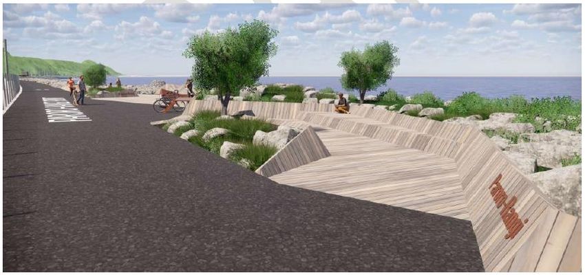
Sensitivity: General

               •       I was previously an Active Transport and Road Safety Coordinator at Greater Wellington
                       Regional Council (2009-2015). Key roles included chairing the Regional Active Transport
                       Forum, managing development of the regional walking and cycling journey planner,
                       development of the 2015 regional strategic walking and cycling network maps, and review
                       of walking and cycling policies in the Wellington region.
               •       I was previously a Partner at Kennett Brothers Ltd (cycling writers, publishers, event
                       organisers, consultants, trail designers and builders) (1994-2009). My role included co-
                       writing ‘RIDE – the story of cycling in New Zealand’, work on several council cycling
                       strategies, and coordinating the development of the national cycling advocates network (for
                       Waka Kotahi).

         I confirm that I have read the Code of Conduct for expert witnesses contained in the Environment
         Court Practice Note 2014. This assessment has been prepared in compliance with that Code. In
         particular, unless I state otherwise, this assessment is within my area of expertise and I have not
         omitted to consider material facts known to me that might alter or detract from the opinions I
         express. I have made my employer (Waka Kotahi) aware of my obligation to give independent
         expert advice when giving evidence under this Code of Conduct.

         4             Project description
         The Project is part of Te Ara Tupua programme of works, which involves the development of
         pedestrian and cyclist facilities between Wellington CBD, Pito-One and Melling. The Project involves
         the construction of a shared path from the Ngā Ūranga Interchange to just south of the Pito-One
         Railway Station in the north and associated works as shown in Figure 1.
         The Project will cater for active transport modes including cycling and walking, and will provide an
         alternative to the existing State Highway 2 (SH2) cycle path located between the Hutt Valley Railway
         Line and the southbound SH2 carriageway. Works at Honiana Te Puni Reserve (the Reserve)
         provide for the removal and replacement of the existing Wellington Rowing Association and
         Wellington Water Ski Club facilities at, and adjacent to, the Reserve and the introduction of new
         cultural facilities into the Reserve.

         The primary objective of the Project and wider Te Ara Tupua programme is to provide safe walking
         and cycling infrastructure between Wellington and the Hutt Valley which will act as a catalyst for
         increased use of active transport modes. The Project will also provide increased transport resilience,
         improve connections and integration with planned and existing walking and cycling infrastructure in
         Wellington City and Hutt City and reconnect people with this long-inaccessible part of the harbour’s
         edge.

         The Project will provide a 4.5km-long shared path between Ngā Ūranga and Pito-One featuring the
         following key elements:
               h) A rail overbridge (the shared path bridge) across the Hutt Valley Railway Line, connecting
                  the shared path from Ngā Ūranga to the coastal edge;
               i) A path with a 5m surface width on existing and newly created land and coastal structures,
                  on the seaward side of the Hutt Valley Railway Line;
               j) A varied coastal edge which incorporates ūranga (landings), a rocky revetment and the
                  intermittent use of strategically placed seawalls along the path edge. The coastal edge
                  treatment provides resilence, reflects the natural landscape, avoids sensitive habitat areas,
                  provides for cultural expression and enhances amenity;
               k) Construction of new offshore habitat for coastal avifauna;
               l) Connections to the Pito-One to Melling (P2M) path and The Esplanade;
               m) Construction of a new Integrated Clubs Building at the eastern end of the Reserve and an
                  associated car parking area; and
               n) A two-stage development of new cultural facilities at the Reserve, including:
                    iii.   Construction of three temporary Tāwharau Pods, consisting of three small building
                           pods designed to accommodate a range of cultural or community uses, at the
                           eastern end of the Reserve; and

                                                                                             NGĀ ŪRANGA KI PITO-ONE SHARED PATH
                                                                                                                     PROJECT // 4
Sensitivity: General

                       iv.    Post-construction, the construction of a Whare to the west of Korokoro Stream, and
                              permanent relocation of the Tāwharau Pods to a site adjacent to the Project at the
                              western end of the Reserve2.

         For description and assessment purposes in this report, the Project has been divided into three
         sectors (as shown in Figure 1 below). These are:
         Sector 1            Ngā Ūranga Interchange and Bridge Crossing:

                             The Southern Construction Yard and the connection from the Ngā Ūranga
                             Interchange via the shared path bridge across the Hutt Valley Railway Line, to the
                             coastal edge.

         Sector 2            Ngā Ūranga to the Reserve - Path and Ūranga:
                             The typical shared path, rock revetment, ūranga, seawall structures and offshore
                             habitats between Ngā Ūranga and the Reserve; and

         Sector 3            The Reserve and Pito-One to Melling (P2M) Connection:

                             Shared path connection to P2M adjacent to the Reserve, connections to the Reserve
                             and The Esplanade, the Northern Construction Yard, Integrated Clubs Building,
                             associated car parking, the temporary and permanent Tāwharau Pods and the
                             Whare.

         Figure 1: Project sectors

         2   The construction of the Whare and Tāwharau Pods is at Taranaki Whānui’s discretion

                                                                                             NGĀ ŪRANGA KI PITO-ONE SHARED PATH
                                                                                                                     PROJECT // 5
Sensitivity: General

         A full description of the Project including design and operation is provided in Chapter 3 Description
         of the Project in the Assessment of Effects on the Environment (AEE).

         A description of the potential construction methodology that could be used to construct the Project is
         provided in Chapter 4 Construction of the Project of the AEE.

         5             Existing environment and strategic context

         5.1           Existing environment

         The existing walking and cycling environment between Ngā-Ūranga and Pito-One is set out in
         detail in Technical Report 3: Integrated Transport Assessment. The existing and future
         recreational values/uses are set out in detail in the Recreation Review: Effects Assessment and
         Future Recreation Values. I concur with those reports’ description of the existing environment and
         summarise the key points below:

               •       At the southern end of the Project there are cycle shoulders, and the existing SH2 cycle
                       path (existing cycle path). Cyclists commuting between the Hutt Valley and Wellington
                       have the option of using the shoulders of SH2 and/or the existing cycle path (between the
                       Hutt Valley Railway Line and SH2).
               •       Cyclists travelling south are required to use the SH2 shoulder for 800 metres south of the
                       Pito-One Interchange and then choose between the SH2 shoulder or the existing cycle
                       path.
               •       Cyclists travelling north are discouraged from using the existing cycle path due to the
                       missing section near Pito-One, where it is illegal to cycle northbound.
               •       On SH2 there is no physical barrier or separation between road users and the cycle lane.
                       Most of the cycle routes available are, at best, only suitable for confident cyclists, and
                       indeed many experienced cyclists avoid it (especially since the fatality in early 2020).
               •       The state of the existing cycle path is also not desirable for cyclists given it is narrow,
                       poorly maintained and the quality of the surface is poor. This makes it difficult to use,
                       particularly for road bikes that require a smooth surface. Further, the existing cycle path, is
                       poorly lit at night and prone to flooding in poor weather.
               •       Pedestrians are able to use the existing cycle path, however, at the 800 metre section
                       south of the Pito-One Interchange, pedestrians must walk on the SH2 shoulder which has
                       no physical protection from the traffic lanes.
               •       The existing environment does not provide a good facility for micro mobility, such as e-
                       scooters, given the standard of the existing cycle path and exposure to high speed traffic
                       along the shoulders on SH2.
         There are a number of existing local and regional connections relevant to the Project, including:

               •       at the southern end of the Project, there is the separate off-road path and paths on the
                       Ngā-Ūranga Gorge connecting to Newlands and Johnsonville;
               •       at the northern end of the Project, there is the Pito-One Foreshore, local road and footpath
                       network and SH2 shoulders;
               •       at the northern end, the Project will also connect with existing regional and national cycle
                       networks, including the Hutt Valley cycle network (which includes the Hutt River Trail),
                       Wainuiomata Hill Shared Path, the Eastbourne shared path; and the Remutaka Cycle Trail.

         5.2           Strategic context

         The strategic context for the Project is set out in detail in the Technical Report 1: Strategic
         Transport Assessment. Again, I concur with that report’s assessment of the strategic context and
         summarise key points relevant to my assessment below:

                                                                                                NGĀ ŪRANGA KI PITO-ONE SHARED PATH
                                                                                                                        PROJECT // 6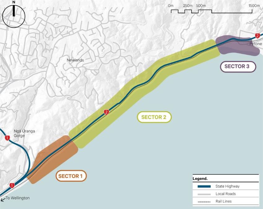
Sensitivity: General

               •       The Project supports the Government Policy Statement’s ("GPS") objectives for active
                       modes. The GPS states that it "supports investment towards improving the safety of
                       cyclists and pedestrians. Improving the safety of cycling and walking is a key part of
                       improving accessibility and encouraging uptake of cycling and walking as preferred
                       transport modes. It also enables transport choice.”3. The GPS further states that the GPS
                       supports investment in: "delivering critical missing links in the urban cycling network in
                       areas of high demand (for example, between…Wellington City Centre and Lower Hutt)”. 4
               •       The Project is part of the wider Te Ara Tupua programme of works, which aims to provide
                       a safe and efficient walking and cycling route between Wellington and Lower Hutt.
               •       In particular, the Project will connect, at its northern end, to the P2M section of Te Ara
                       Tupua. The P2M project began construction in 2019 and will provide a safe, separated
                       path for cyclists between a location south of the Pito-One railway station and the Hutt River
                       Trail at Bridge Street (Normandale).
               •       At the southern end, the Project will connect the Wellington CBD to Ngā Ūranga section of
                       Te Ara Tupua:
                            o Large sections of that part of the route are already complete. The existing shared
                                path adjacent to Hutt Road has been upgraded between Tinakori Road and the
                                Caltex service station south of Onslow Road. The section from the Caltex service
                                station to Ngā Ūranga is expected to be widened before the Project opens.
                            o The section south of Tinakori Road (along Thorndon Quay) is being investigated
                                as part of the Let’s Get Wellington Moving (LGWM) project
               •       The Project will deliver the most critical link between Wellington and the Hutt Valley due to
                       the lack of existing facilities and the high-speed traffic environment.

         Figure 2: Te Ara Tupua (Wellington to Hutt Valley Walking and Cycling Project) 5

         3 Page 12 of the Government Policy Statement 2018:
         https://www.transport.govt.nz/assets/Uploads/Our-Work/Documents/c6b0fea45a/Government-
         Policy-Statement-on-land-transport-2018.pdf
         4 Page 17 of the Government Policy Statement 2018.
         5 https://nzta.govt.nz/assets/projects/wellington-to-hutt-valley-walking-and-cycling-link/w2hvc-

         overview2.pdf

                                                                                              NGĀ ŪRANGA KI PITO-ONE SHARED PATH
                                                                                                                      PROJECT // 7
Sensitivity: General

         5.3           Conclusion on existing environment and strategic context
         The existing environment currently does not provide for a safe and efficient cycling and walking
         route between Wellington and Lower Hutt. The use of the Project area by pedestrians and cyclists
         is limited and the ability for the community to utilise this area for recreational and commuter
         purposes is not being fully realised.

         The Project will not only address the lack of facilities in this location but will also link with the wider
         transport network programme and provide a critical link in this programme of works.

         6             Cycling and walking demand analysis
         This section provides an estimate of use/demand for the shared path once it is completed.

         An estimate was previously included in Aecom’s ‘Wellington to Hutt Valley Cycle and Pedestrian
         Link Detailed Business Case’ (2015) where it was estimated that there would be an average of 730
         cyclists and 50 walkers/runners using the new path between Ngā Ūranga and Pito-One each day,
         in the year after opening.

         However, significant developments have occurred since 2015, which mean the 2015 estimate
         should be reviewed and revised. In this section, I describe the methodology I have used to develop
         a more realistic estimate of use/demand for the shared path. Rather than updating the estimate
         using the methodology in Research Report 340 (Estimating demand for new cycling facilities in
         New Zealand, 2007), this more recent estimate is based on growth in cycling and walking observed
         over the last decade along similar paths in Australasia. Experience over the last five years
         suggests that we should expect far greater uptake of high-quality paths than previously observed,
         in part due to a surge in the uptake of e-bikes/e-scooters and also due to significant improvements
         in the quality of ‘best practice’ shared path design since the launch of the Urban Cycleways
         Programme in 2015.

         This section is structured as follows:

         6.1 – Summary and review of previous estimate

         6.2 – Estimate of use
         6.3 – Existing background growth in active modes in Greater Wellington

         6.4 – Population growth and urban development

         6.5 – Comparison with growth experienced where similar paths have been constructed
         6.6 – Comparison with other demand estimates

         6.7 – Other Cycling Network Developments expected to Grow Demand by 2025

         6.8 – Conclusion.

         6.1           Summary and review of previous estimate

         As noted above, an estimate was previously included in Aecom’s ‘Wellington to Hutt Valley Cycle
         and Pedestrian Link Detailed Business Case’ (2015) where it was estimated that there would be an
         average of 730 cyclists and 50 walkers/runners using the new path between Ngā Ūranga and Pito-
         One each day, in the year after opening.

         However, recent developments have seen a much stronger demand for long shared use paths than
         previously expected or experienced. There are several reasons for this as follows:

               •       There has been a sustained surge in e-mobility (due to significant improvements in battery
                       and controller technology, and e-bike affordability). Attached as Appendix A to this report

                                                                                              NGĀ ŪRANGA KI PITO-ONE SHARED PATH
                                                                                                                      PROJECT // 8
Sensitivity: General

                       is information on e-bike imports which shows the developing popularity of this mode of
                       transportation.
               •       The wider cycling network has been developed, including
                            o sealing of the western end of The Esplanade shared path;
                            o completion of the Wainuiomata shared path;
                            o upgrade of the Hutt Road cycleway between Caltex and Thorndon Quay;
                            o installation of a cycle lane on Featherston Street (south of Bunny Street);
                            o minor safety improvements on SH2 between Belmont and Ngā Ūranga;
                            o completion of 500m of cycle path north of Ngā Ūranga; and
                            o sealing of several kilometres of the Hutt River Trail (north of Avalon).
               •       Cycling has been promoted with the ‘Ride More – Feel More’ campaign and Aotearoa Bike
                       Challenge.
               •       There has been a decline in on-road recreational cycling in favour of cycling away from
                       traffic (e.g. cycle trail and gravel road riding). For example, there was a decline of the
                       Taupo Cycle Challenge and at the same time a surge in popularity of New Zealand Cycle
                       Trail trails and ‘Bike-packing’.
               •       Trails such as the Remutaka Cycle Trail have been designated and promoted as ‘Great
                       Rides’.
               •       There has been a rise in population (e.g. 1.3% per annum in Lower Hutt from 2013 to
                       2019).
               •       Recent experience with the development of high-quality cycleways demonstrates that there
                       is a much higher demand for separated facilities than previously suggested in Research
                       Report 340 (Estimating demand for new cycling facilities in New Zealand, 2007).
         Although Aecom’s methodology was sound in 2015, it was conservative and should now be revised
         in light of the recent developments referred to above as well as the following:

               •       The proportion of riders likely to stay on a highway after a high-quality shared path is
                       constructed is low. This is demonstrated by the fact that only 2.7% of southbound Hutt
                       Road cyclists are staying on the road since the shared path has been upgraded.
               •       The large step-change in use experienced on other projects when a popular cycling route
                       is upgraded from level of service (LOS) D/E (i.e. on-road shoulders next to a high volume
                       of traffic) to LOS A/B (fully separated shared use path with ample width).
               •       The high background growth in cycling in Wellington as documented in reports such as
                       Greater Wellington’s State of Cycling Report 22001-2012.6
               •       Improvements in e-bike performance and affordability, which have significantly increased
                       the appeal of cycle commutes over 5 km in length. Research in seven European cities (by
                       A Castro et al, 2019) found that the average e-bike trip was 9.4km compared with an
                       average trip length of 4.8km on conventional bikes.

         An additional factor to be taken into account is the ‘network effect’ – an increase in the use of this
         Project’s shared path can be expected as a result of the upgrade or construction of other parts of
         the cycling network that feed into it. The network has seen some significant development since
         2016, and design and construction are well underway on further parts of the network (to be
         completed prior to the completion of the Project or soon after, as referred to above in section 5).

         Any assumption that the completion of the shared path would lead to 100% of existing riders
         voluntarily switching from the road to the path would be unrealistic. Even given the recent fatality
         on SH2 by the BP service station, it is likely a small percentage will continue to ride on the highway
         shoulder because they can travel slightly faster there. Based on the level of road riding on the
         Kapiti Expressway and former SH1, it is reasonable to assume that approximately 5-10% of the
         current riders will stick to the highway after the shared path is completed (with 5% based on a path
         width of 5m, vs 10% based on a path width of 3m).

         Based on recent experience with similar projects, Aecom’s step change estimate of 62% is
         conservative. A step change of 100% or more in cycling numbers in the first year now appears

         6https://www.gw.govt.nz/assets/Transport/Walking-and-Cycling/StateofCyclingReport2001-
         2012.pdf.

                                                                                            NGĀ ŪRANGA KI PITO-ONE SHARED PATH
                                                                                                                    PROJECT // 9
Sensitivity: General
realistic, assuming significant promotion, completion of the P2M shared path, and an upgrade in
cycling LOS along Thorndon Quay.
On top of the growth in cycling between Pito-One and Ngā Ūranga, the step change increase in
recreational walking/running and transport device (e.g. e-scooters, e-skateboards, etc) use is likely
to be very high. The highest growth experienced on the Wainuiomata Hill shared path was in
walking. While walkers greatly outnumber cyclists on the Wainuiomata shared path, this is partly
due to this route being very hilly (cyclists are much more grade-sensitive than walkers).
This contrasts with use of the much longer and more utilitarian Northwestern shared path, where
pedestrians make up only around 17% of users (and cyclists 83%). Pedestrian mode share of 17%
is also predicted by FLOW’s mode share assessment for the section of Northern Pathway between
Sulphur Beach and Stafford Road. While the Project will be less accessible for short
neighbourhood walks, it will appeal to walkers and runners keen on exercise routes uninterrupted
by roads, fishers keen to access a sheltered part of the harbour, and pedestrian activity associated
with the Integrated Clubs Building and new whare at the Reserve.
Transport devices users (i.e. e-scooter riders) grew from virtually zero to 5% mode share at the
Kingsland end of the Northwestern shared path between 2015 and 2019. Based on improving
technology and the enabling rules proposed in the Accessible Streets package, growth in transport
device mode share is likely to remain strong. However, existing shared e-scooters are not
inexpensive to hire and are of the stand-up variety, so are better suited to short trips. We have
estimated that transport device users will make up 10% of total path users on weekdays in 2025. A
large portion of transport device trips are likely to be recreational in nature.
In 2020, with the benefit of several more years of cycle count data, it is looking likely that the post-
construction annual growth in cycle commuting between Hutt Valley and Wellington will exceed
Aecom’s 2015 estimate of 6% per annum. for the first ten years, followed by 3% per annum. Even
in the current scenario, the background growth of cycling at the SH2 off-ramp on Hutt Road has
been approximately 8% per annum since 2015.
The next section explains how the demand/use estimate has been re-calculated, taking the above
factors into account.
6.2 Revised estimates of use on the Ngā Ūranga to Pito-One Shared Path
The revised demand estimate carried out for this report has resulted in the following estimates:
• It is estimated that within 12 months of completion of the Project, path use will grow to an
average of 1,812 visits (total of both directions) per weekday, with 75% of users being
people on bikes. AM peak hour use is expected to be 320 people.
• A similar number of visits are expected on an average weekend day, although with a
significantly higher proportion of users being on foot.
• Path use is expected to double between 2025 and 2035.
This estimate is based on the following assumptions, for weekday use:
• Assumption 1: In order to predict the base use at the shared path’s opening (2024), the
same assumptions in the Aecom 2015 estimate have been applied. This is based on:
o 450 cyclists per day in 2015.
o A conservative prediction of growth of 2% per annum from 2020 to 2024. While a
higher level of growth (8% per annum) has been experienced at the Hutt
Road/SH2 off-ramp since 2015, and is likely to have been experienced between
Pito-One and Ngā Ūranga, a lower level of growth is now expected following the
death of a person cycling on this section of highway in early 2020. Also, with the
COVID-19 pandemic likely to lead to a recession, commuting numbers may
stagnate for a number of years (as seen during the Global Financial Crisis).
o Therefore, base use in 2024, prior to the shared path opening, is expected to be
approximately 715 cyclists per day.
NGĀ ŪRANGA KI PITO-ONE SHARED PATH
PROJECT // 10Sensitivity: General
o In addition, approximately 2-5 pedestrians per day are assumed in the base case
(based on observations by the author and the Strava heatmap, which is provided
in Appendix B).
o One e-scooter rider has also been seen using the road shoulder regularly in 2020
and so 1 e-scooter user per day has also been assumed in the base use scenario.
• Assumption 2: 95% of current cyclists will shift to the shared path once it is open (based
on a path width of 5m). There will also be a step-change increase of 60-150% within the
first 12 months. For the purpose of this estimate, an initial step change of 100% within 12
months of completion has been assumed. This assumes extensive development of the
wider cycling network (as outlined above in Section 5) and vigorous promotion of the
Project around the time of the shared path completion.
• Assumption 3: Walkers/runners will make up approximately 15% of total weekday users,
as they do on the Northwestern shared path near Kingsland. The majority of these users
will walk or run only a portion of the path, mostly starting and finishing at the Pito-One end.
• Assumption 4: Transport device users will make up approximately 10% of total weekday
users (based on a doubling of their current proportion of users of the Northwestern shared
path). Higher mode share is possible but would largely be at the expense of walking and
cycling mode share, so will not affect overall numbers greatly.
• Assumption 5: Based on the strong growth in cycling along this corridor, and on the
Northwestern shared path where growth in cycling has averaged 17% per annum since
2015, 10% per annum growth in cycling and transport device use has conservatively been
assumed for the first five years after the initial step-change, followed by 5% per annum for
the second five years, and 2% per annum from 2035-2050. Without the boost given by the
e-bike and transport device boom, or the cycling ‘network effect’, pedestrian use is
expected to grow at 6% per annum in the first five years (i.e. similar to the ratio of
pedestrian vs cycling growth seen on the Northwestern shared path over the last four
years).
• Assumption 6: Based on the Northwestern shared path use, the 95th percentile of user
numbers will be close to 50% higher than the mean. If the shared path begins to feel too
crowded, some recreational users will choose to go elsewhere.
The estimated numbers derived from the assumptions above are set out in Table 1 below.
Table 1 - Estimated average weekday use (both ways)
Mode Base use Users 12 Users by Users by Users by
(prior to months after 2030 (based 2035 (based 2050 (based
opening, completion on cyclist on growth of on growth of
2024) (2025) and transport 5% per 2% per
assuming device annum for all annum for all
step change growth of modes) modes)
of 100% in 10% per
cycling (and annum and
5% use the 6% for
highway) pedestrians)
Cyclists 715 1,359 2,189 2,794 3,760
Walkers/runners 2 272* 364 465 626
Transport 1 181 292 372 501
device riders
Total mean use 721 1812 2,845 3,631 4,887
th
95 percentile 1,081 2,718 4,268 5,447 7,331
* Only around 50 of these walkers/runners are expected to travel the full length of the shared path.
NGĀ ŪRANGA KI PITO-ONE SHARED PATH
PROJECT // 11Sensitivity: General
In order to estimate the weekday AM peak hour use, the following additional assumption has been
applied:
• Assumption 6: The weekday AM Peak Hour use will be 20% of the daily total for cyclists,
8% of the daily total for walkers/runners, and 15% of the daily total for transport device
riders.
The estimated numbers given by applying these assumptions are shown in Table 2 below.
Table 2 - Estimated average AM Peak Hour use
Weekday AM Peak 2025 2030 2035 2050
Hour Users
Cyclists 271 438 559 752
Walkers/runners 22 29 37 50
Transport device 27 44 56 75
riders
Total 320 511 652 877
95th percentile 480 767 978 1,316
In order to estimate the likely weekend use, the following additional assumption has been applied:
• Assumption 7: The following weekday/weekend ratios have been applied based on
experience on similar projects:
o A ratio of 1:1.8 for pedestrians based on experience on the Wainuiomata Hill
shared path;
o A ratio of 1:0.8 for cyclists based on experience on the Northern shared path near
Te Atatu (the actual ratio on the Northern shared path is 1:1.05, however, cycling
is prohibited on the adjacent highway and off-road cycling options are less
common, therefore 1:0.8 has been assumed for this Project);
o A ratio of 1:1.5 for transport device users, based on the assumption that transport
device use will be largely recreational.
The estimated numbers resulting from applying these assumptions are shown in Table 3 below.
Table 3 - Estimated average weekend day use
Weekend-day Users by 2025 Users by 2030 Users by 2035 Users by 2050
Both ways after path (based on 10% (based on 5% (based on 2%
opening step p.a. growth after p.a. growth p.a. growth after
change 2025) after 2030) 2035)
Cyclists 1,087 1,751 2,235 3,008
Walkers/runners 490 655 837 1,127
Transport device 272 438 558 751
riders
Total 1,849 2,844 3,630 4,886
95th percentile 2,774 4,266 5,445 7,329
While these weekend daily use estimates are higher than the weekday estimates, the peaks will be
less pronounced. For an idea of how shared path use might be distributed between the weekday
versus weekend days in 2025, see Figure 3 below. This model of hourly use is based on observed
pedestrian use of the Wainuiomata shared path and cycling use of the Hutt Road shared path.
NGĀ ŪRANGA KI PITO-ONE SHARED PATH
PROJECT // 12Sensitivity: General
Estimated use at North end of Path by Mode and
Hour of Day in 2025
Transport Devices weekday Transport Devices weekend day
Pedestrians weekday Pedestrians weekend day
Cycle weekday Cycle weekend day
300
250
Estimated use per hour
200
150
100
50
0
1 2 3 4 5 6 7 8 9 10 11 12 13 14 15 16 17 18 19 20 21 22 23 24
Hour of day
Figure 3: Estimated use at North end of shared path.
The following sections explain in more detail the basis for the assumptions used to derive an
estimate of use/demand for the shared path.
6.3 Existing background growth in active modes in Greater Wellington
Against the national trend, Wellington saw growth in active travel mode share between 1986 and
2006, albeit starting from a low base. The trend continues and is supported by a well-developed
public transport system, limited and costly car parking, and the lowest rate of motor vehicle
ownership in New Zealand. This is demonstrated in Figure 4 below.
NGĀ ŪRANGA KI PITO-ONE SHARED PATH
PROJECT // 13Sensitivity: General
Figure 4: Proportion of trips taken by cycling and walking across six cities
Despite little development in Wellington’s cycling network up to recent years, there has been strong
growth in the Wellington City Council’s Cycle Commuter Survey Count since 2004 (see Figure 5
below). This indicates growing enthusiasm for cycling as a transport choice, motivated by a range
of benefits and concerns.
NGĀ ŪRANGA KI PITO-ONE SHARED PATH
PROJECT // 14Sensitivity: General
Figure 5: Commuter cycle volumes 2001-2019 (Figure 8-1, Transport Monitoring Surveys,
May 2019, Stantec)
The closest historical cycling count to the Project is at SH2 off-ramp at Jarden Mile, Ngā Ūranga.
Cycling to or from this location involves mixing with traffic that is often travelling at high speed – a
risky endeavour that is not appealing to a large percentage of the population (particularly women,
as shown in Appendix C).
As shown in Figure 6 below, a count at this location shows 70 cyclists/peak hour in 2009 climbed
133% to 163/peak hour in 2019 (from WCC data).
This equates to an average of 7% growth per annum since 2009. The growth between 2014 and
2019 is slightly higher, at an average of 8% per annum (compound growth). This change in growth
may be explained in part by the increased availability, quality and affordability of e-bikes. Appendix
A provides information about e-bike and e-scooter imports and shows that New Zealand e-bike
imports have grew from approximately 15,000 to 38,000 between 2016 and 2019, while e-scooter
imports grew from a few hundred to more than 25,000 over the same period.
NGĀ ŪRANGA KI PITO-ONE SHARED PATH
PROJECT // 15Sensitivity: General
Figure 6: Results of the WCC cycle count at the SH2 off-ramp onto Hutt Road/Jarden Mile,
Ngā Ūranga.
A significant factor influencing cycling uptake over the long term has been the cost and time of
cycle commuting between Pito-One and Wellington relative to the main alternatives of driving or
catching the train. Table 4 below illustrates indicative costs for the 13-kilometre return trip between
the corner of Richmond and Jackson Streets and the corner of Willis Street and Lambton Quay
during the AM and PM peaks. This Table shows that cycling is much cheaper than travelling by
train or car, and is comparative in terms of time.
Table 4 – Cost and time of trip by mode for a return trip between Pito-One and Wellington
CBD
Mode Cost Time
Cycle $2.60 (at 10c/km, author’s 35 min (at an average speed of
estimate of typical running cost) 25 kph; incl 4 mins to change
clothes)
Train $8.40 (using 10-trip ticket) 35 min (based on Metlink
timetable; incl a 10 min walk at
each end of the train trip + 3 min
wait at station)
Car $23.80 (at 30c/km, the standard 28 min** (incl 3 min walk from
IRD rate for a mid-size car, plus car park)
$16* parking fee)
* Parking rates vary greatly in Wellington. The standard ‘Earlybird’ rate for commuter parking at a
Wilson Parking facility is between $16 and $22. Many drivers have free work car parks, while
others pay more than the ‘Earlybird’ rate.
** Driving times vary significantly depending on traffic conditions. A typical commute time is used
here (Source, BlipTrack by Beca).
In summary, existing background growth in cycling trips in Wellington City shows that there is
growing interest in cycling as a mode of transport, despite the overall cycling network having a level
of service that is unattractive to a large portion of the population.
NGĀ ŪRANGA KI PITO-ONE SHARED PATH
PROJECT // 16Sensitivity: General
6.3 Population growth and urban development
Population growth in Hutt City is forecast to continue at around 1% per annum. Approximately 80%
of new dwellings are expected to be provided through residential intensification in Lower Hutt
central city, Pito-One (within easy cycling distance of the Project) and other locations along the
public transport corridor (which will be serviced by the Beltway Cycleway). This is demonstrated in
Figure 7 below, which comes from the ‘Lower Hutt Growth Story’, which is a living document put
together by HCC, GWRC and Waka Kotahi for planning purposes
NGĀ ŪRANGA KI PITO-ONE SHARED PATH
PROJECT // 17Sensitivity: General
Figure 7: Location of growth/new developments across Lower Hutt (Source, Lower Hutt
Growth Story, HCC, March 2018)
Population growth in Hutt City and residential densification in Lower Hutt and Pito-One will be a
significant contributor to growth in use of the path, particularly after the initial period of mode shift
and recreational discovery of the path begins to wane.
6.4 Comparison with growth experienced where similar paths have been constructed
This section summarises recent experience with similar projects throughout New Zealand and
overseas. These comparable projects have been used to inform the assumptions applied to
estimate the anticipated use/demand for this Project, as explained above in Section 6.2 of this
report.
6.4.1 Wainuiomata shared path
The new 4m wide Wainuiomata shared path was completed in 2019. Table 5 below illustrates the
significant increase in active users (pedestrians and cyclists) of the Wainuiomata Hill route since
the completion of the shared path, recorded through a counter on the shared path. The Table
records the number of active users heading down the path per month.
The path user data comes from an in-situ counter. An estimate of road cycling use has been made
using the Strava heatmap (Appendix C) and segment data, which suggests that most road cyclists
have moved to the path.
Table 5 – Increases in walking and cycling before and after construction of the Wainuiomata
Hill shared path
Wainuiomata Hill Shared Path Bicycle and Pedestrian Counter
Counter Location: Lower Hutt side
Direction: Downhill towards Lower Hutt
November 2018 November 2019 Difference
Pedestrians 1,105 2,783 152% pedestrians
Cyclists 137 (+273 road cyclists) = 594 (+60 road 60% cyclists
410 cyclists) = 654
Combined 1,515 3,437 127% active users
Table 5 shows the number of people travelling downhill. The number of cyclists riding up the
Wainuiomata shared path is much higher, but that is most likely attributable to mountain bikers
opting for the shared path when travelling uphill (the gradient is less and the surface is more
efficient) on their way to mountain bike trails, so is not comparable with the Project situation.
Therefore, Table 5 only shows the number of downhill users of the path heading towards the Hutt
Valley.
The relatively low number of cyclists compared with pedestrians is understandable given that
cyclists are more grade-sensitive and the Wainuiomata Hill is a steep, 200m high climb.
Pedestrian use is dominated by weekend recreational use (see Figure 8 below).
NGĀ ŪRANGA KI PITO-ONE SHARED PATH
PROJECT // 18Sensitivity: General
Daily Average Cycle and Pedestrian Count Wainuiomata
SUP (Lower Hutt Side) Northbound Users in Q1 of 2019
Average Bicycle Count Average Pedestrian Count
86
77
54
48
44 42
41
16
11
7 6 7 6 6
Monday Tuesday Wednesday Thursday Friday Saturday Sunday
Figure 8: Average daily count of cyclists and pedestrians on Wainuiomata Hill shared path.
Figure 8 shows that the ratio of typical weekday use to typical weekend day use is 1:1.8 for
pedestrians.
6.4.2 Northwestern Cycleway shared path
The 3m wide Northwestern Cycleway shared path is over 11 km long and runs generally parallel
with SH16 from Massey into the Auckland CBD. A cycling counter at Te Atatu (11km from the
CBD) has been collecting data since late 2010. Since then, cycling use has been growing by an
average of 9% per annum. (See Figure 9 below.) This growth has been supported by cycling
network developments in the Auckland CBD and cycling promotion.
The higher, 17% per annum growth rate over the last five years is consistent with the high growth
of e-bike and e-scooter imports to New Zealand (see Appendix A). In Electric City: E-bikes and the
future of cycling in New Zealand (Wild and Woodward 2018) it was noted that e-bikes had made
longer commutes and trip-chaining significantly easier, making cycling more realistic for women.
While women made up only 27% of cyclists on the Northwestern shared path, they made up 41%
of e-cyclists.
This shared path is not a particularly scenic route, however, it is one of the longest ‘safe’, sealed
cycling routes in Auckland, and recreational use is high. The ratio of average weekday use to
average weekend use in January 2020 is 1:1.05.
NGĀ ŪRANGA KI PITO-ONE SHARED PATH
PROJECT // 19Sensitivity: General
Northwestern SUP Cycle Counts at Te Atatu
300000
250000
Annual Cycle Count Totals
200000
150000
100000
50000
0
2010 2011 2012 2013 2014 2015 2016 2017 2018 2019 2020
Figure 9: Cycle count on the Northwestern Cycleway shared path
Figure 10 shows daily pedestrian counts on the Northwestern shared path at Kingsland (the only
location with a pedestrian counter). The trendline suggests average daily pedestrian numbers have
increased from approximately 150 to 230. This equates to growth of around 10% per annum. Note
that seasonal variation has increased over time.
Daily Pedestrian Count on Northwestern SUP, at Kingsland,
2016-2019
600
500
Daily Pedestrian Count
400
300
200
100
0
0 200 400 600 800 1000 1200 1400 1600
Number of days since 1st Jan 2016
Figure 10: Daily pedestrian count on the Northwestern shared path
NGĀ ŪRANGA KI PITO-ONE SHARED PATH
PROJECT // 20Sensitivity: General
6.4.3 Freemantle Railway Principal Shared Path (PSP)
Completion of a 3km section of the Freemantle Railway PSP (shown as the southern end of the
blue line near the coast in Figure 11 below)) in August 2019, combined with a vigorous promotion,
saw a 94% increase in cycling numbers on the 20 km Freemantle Railway PSP (despite several
kilometres yet to be completed).
Figure 11: Freemantle Railway Principal Shared Path
The Perth-Freemantle Railway shared path experienced an almost doubling of demand compared
to the same quarter in 2018. This can be explained by the extension of the path to the south which
opened in August 2019 and resulted in an immediate increase in cycling numbers (shown in Figure
12, below).
NGĀ ŪRANGA KI PITO-ONE SHARED PATH
PROJECT // 21Sensitivity: General
Figure 12: Daily demand at Perth-Fremantle Railway Line Principal Shared Path (Grant
Street)
Figure 12 above shows that this growth occurred as a result of completing 3km of path from Grant
St to Victoria St Station, just over 10 km from the Perth CBD. This section of path runs between
houses and the railway line, and is not particularly scenic. The path from Victoria St Station to
Freemantle remains incomplete.
6.4.4 Brisbane principal cycleways
Brisbane has a similar population density and transport culture to Wellington. Their cycleway
network includes long-distance, high quality cycle paths and shared paths. Between 2000 and
2018, use of their key Velo 1 and Centenary Bikeways has grown by 400%. (See Figure 13.)
E-bike use in Australia is limited to bikes with motor output of 250W and a top speed of 25 kph
(compared with fast e-bikes capable of up to 45 kph available (and popular) in New Zealand). This
is limiting the appeal of e-bikes for long distance cycle commuting.
NGĀ ŪRANGA KI PITO-ONE SHARED PATH
PROJECT // 22Sensitivity: General
Figure 13: Average daily cycling use on Brisbane’s two principal cycleways
6.4.5 Hastings to Havelock North shared path
Due to cycle lane and recreational path construction in Hastings (as part of the Model Community
project) cycling was growing steadily on Havelock Road from 2010 and 2011, prior to the
completion of the Havelock North Road shared path. Hastings to Havelock North is a distance of
4 km, and the road linking the two was busy with fast-moving traffic. In 2011, the road had cycle
lanes, but no paths. In 2012 a shared path was constructed. This (along with iWay promotion and
wider network development) contributed to a step-change in cycling of over 300% along this shared
path between 2011 and 2013.
The green and orange lines in the Figure 14 below show the directional cycle volumes recorded by
a newly installed permanent counter in late 2013. (Note that more people use the shared path
when riding towards Havelock North, as it is on the left side of the road when travelling in that
direction). The pink lines represent average daily cycle volumes obtained from ATC (Automatic
Trail Counter) data.
NGĀ ŪRANGA KI PITO-ONE SHARED PATH
PROJECT // 23Sensitivity: General
Figure 14: Directional cycle volumes a permanent counter installed in late 2013 at Hastings
to Havelock North Shared Path 7
7 Source: Owen Mata, former Hastings Model Community project manager
NGĀ ŪRANGA KI PITO-ONE SHARED PATH
PROJECT // 24Sensitivity: General
6.4.6 Great Taste Trail, Richmond
Nelson’s Great Taste Trail is a NZ Cycle Trail ‘Great Ride’, as the Ngā Ūranga to Pito-One Shared
Path will be. It varies widely in quality. The following data comes from an EcoCounter on the
northern outskirts of Richmond, where the trail runs between SH6 and the foreshore. At 1.5-2.0m in
width, this is a substandard shared path attracting relatively few walkers (i.e. a one-way count of
around 60 per day). Nevertheless, the growth in walking/running use and the distribution in use
throughout the day offers some interesting insights.
Figure 15 below shows weekly pedestrian traffic trending upwards between summer 2018 and
summer 2020, at a rate around 50% per annum. (prior to the spikes in activity experienced during
the COVID-19 Level 4 lockdown which commenced on 25 March 2020).
Figure 16 illustrates the hourly distribution of pedestrian use during weekdays and weekend days.
Figure 15: Weekly pedestrian traffic at Great Taste Trail, Richmond
Figure 16: Hourly pedestrian traffic at Great Taste Trail, Richmond
NGĀ ŪRANGA KI PITO-ONE SHARED PATH
PROJECT // 25Sensitivity: General
6.4.7 Hutt River Trail, Lower Hutt
Similar to the Great Taste Trail, this data comes from an EcoCounter pedestrian counter on a NZ
Cycle Trail ‘Great Ride’. This counter is situated north of Lower Hutt on the Remutaka Cycle Trail.
The path is 2.2m wide with room to step aside if a group of cyclists approach. Weekday and
weekend day average counts since 1 January 2018 have been 53 and 83 respectively (one-way).
Figure 17 below shows weekly pedestrian traffic trending upwards between summer 2018 and
summer 2020, at a rate of around 20% per annum. (prior to the spike in activity experienced during
the COVID-19 Level 4 lockdown which commenced on 25 March 2020).
Figure 18 illustrates the hourly distribution of pedestrian use during weekdays and weekend days.
Figure 17: Weekly pedestrian traffic at Hutt River Trail, Lower Hutt
Figure 18: Hourly pedestrian traffic at Hutt River Trail, Lower Hutt.
NGĀ ŪRANGA KI PITO-ONE SHARED PATH
PROJECT // 26Sensitivity: General
6.4.8 The Esplanade shared path, Pito-One
Similar to the Great Taste Trail, this data comes from an EcoCounter pedestrian counter on a NZ
Cycle Trail ‘Great Ride’. This counter is situated on The Esplanade shared path, near William
Street, on the Remutaka Cycle Trail. The shared path is only 2m wide, with no room to step to the
side – many cyclists prefer to ride on the road and many walkers prefer to walk on the beach.
Weekday and weekend day average counts since 1 January 2018 have been 160 and 253
respectively (one-way).
Figure 19 below shows weekly pedestrian traffic increasing dramatically in summer 2019. However,
in summer 2020 a counter failure has occurred. There is no spike in activity experienced during the
COVID-19 Level 4 lockdown, probably because the path is too busy and narrow to allow for the
recommended 2m social distancing.
Figure 20 illustrates the hourly distribution of pedestrian use during weekdays and weekend days.
Figure 19: Weekly pedestrian traffic at the Esplanade Shared Path, Pito-One
Figure 20: Hourly pedestrian traffic at the Esplanade Shared Path, Pito-One
This is the closest counter to the Project’s proposed shared path, but it has a far more urban
setting. The Esplanade shared path has two-way pedestrian use averages of 320/weekday and
503/weekend day, which are lower than projected use of the Project’s shared path. However, this
counter undercounts total pedestrian activity as it does not include those walking or running on the
beach (or on the other side of The Esplanade). Its use is also limited by its minimal 2m width.
NGĀ ŪRANGA KI PITO-ONE SHARED PATH
PROJECT // 27Sensitivity: General
Overall, data relating to The Esplanade shared path gives some indication of the scale of
pedestrian use that can reasonably be expected at the northern end of the proposed Ngā Ūranga
to Pito-One shared path. The ratio of weekday to weekend day use is 1:1.6, compared with 1:1.8
on the Wainuiomata Hill shared path. The latter, more rural example is closer to what is expected
for pedestrian use on the Ngā Ūranga to Pito-One shared path: both are considered to be 'rural' as
they both adjoin a high-speed traffic environment and the adjacent land is neither residential nor
commercial.
6.4.9 Marine Parade shared path, Napier
Similar to the Great Taste Trail, this data comes from an EcoCounter pedestrian counter on a NZ
Cycle Trail ‘Great Ride’. This counter is situated on the Marine Parade shared path, adjacent to the
National Marine Centre, 1 km south of the centre of the Napier CBD. The path is about 3m wide,
with plenty of room to step to the side. There is also an on-road cycle lane available on Marine
Parade, and footpaths. Weekday and weekend day average pedestrian counts on this path since
1 January 2018 have been 428 and 573 respectively.
Figure 21 below shows weekly pedestrian traffic varying hugely on a seasonal basis. However no
overall trend is evident. This path is almost a decade old. Tourism plays a large role in its
popularity, hence the dip in March 2020, during the COVID-19 pandemic. Figure 22 illustrates the
hourly distribution of pedestrian use during weekdays and weekend days.
Figure 21: Weekly pedestrian traffic at the Marine Parade Shared Path, Napier
Figure 22: Hourly pedestrian traffic at the Marine Parade Shared Path, Napier
NGĀ ŪRANGA KI PITO-ONE SHARED PATH
PROJECT // 28Sensitivity: General
6.4.10 Summary of growth experienced in similar projects/environments
Table 6 below summarises data from the above examples to derive typical growth patterns of use
following the construction of shared path facilities.
Table 6 – Typical Growth in Use of Shared Use Paths and NZCT Cycle Trails
Project Step change Ongoing growth
Wainuiomata SUP +127% in active modes in 12
months
Northwestern SUP Cycling - 9% p.a. since 2011 and 17%
since 2015
Pedestrians – 10% p.a since 1st Jan 2016
Perth-Freemantle PSP +94% in cyclists in three months
Havelock SUP +300% in 24 months
Promotion of cycling in Approx 8% p.a. growth at Hutt Road SH2
Wellington region off-ramp since 2014
Great Taste Trail, Pedestrians – Approx. 50% p.a.
Richmond
Hutt River Trail, Lower Pedestrians – Approx. 20% p.a.
Hutt
Marine Parade SUP, Pedestrians – Approx. 0% p.a.
Napier
Typical growth Approx 110% (i.e. mean of 94 Cycling approx. 8-17% p.a. since 2015
and 127%) in first year* Pedestrian approx. 20% p.a. since 2012
(i.e. the median of the case study
values)
Note: * Assumes path promotion and wider network development
6.5 Comparison with other demand estimates
This section summarises three studies that have estimated demand/use of cycling and walking
facilities in New Zealand.
6.5.1 Cycling Demand Analysis (Dodge, et al, WCC 2014)
This report details the modelling and analysis of a large Wellington cycling survey to estimate the
potential demand for a variety of cycle facility types proposed for the Island Bay to city cycleway.
The authors’ analysis concluded:
“If an ideal route is chosen between Island Bay and the Wellington CBD, cycling numbers
nearly triple. Even more growth is possible if just a few of the people who don’t own bikes
were to buy or be provided with one.”
By ‘ideal’, the authors mean a direct, separated cycleway. This work suggests a much higher
preference for separated cycleways over on-road cycle lanes than indicated in Waka Kotahi
Research Report 340 or the Transport Agency Economic Evaluation Manual (EEM). This view is
supported by the widely used work of Roger Geller and Jennifer Gill of Portland into the potential
and typology of people who do (or might) cycle for transportation. 8 In the local context, their work is
supported by GWRC’s Transport Perception Surveys and State of Cycling Report 2001-2013,
8 https://www.portlandoregon.gov/transportation/article/264746
NGĀ ŪRANGA KI PITO-ONE SHARED PATH
PROJECT // 29You can also read