Northland
Walking and Cycling
     Strategy
←
→
Page content transcription
If your browser does not render page correctly, please read the page content below
Northland
Walking and Cycling
Strategy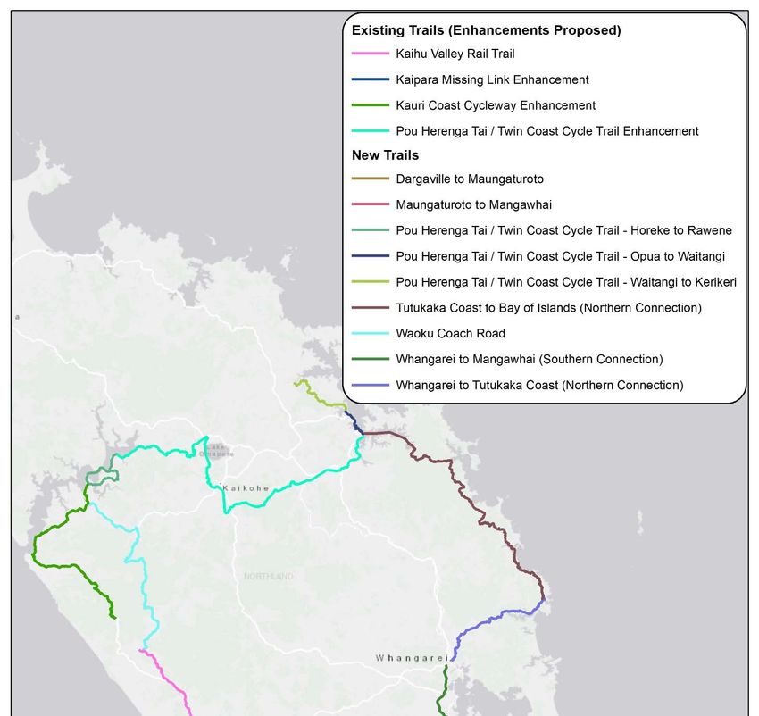
2
Contents
Executive Summary ..................................................................................................... 6
Introduction .............................................................................................................. 10
A.1. Issues and opportunities..................................................................................... 11
A.2. Growing demand for walking and cycling .......................................................... 12
A.3. Strategic framework and linkages....................................................................... 15
B. Strategic Focus Areas ............................................................................................ 21
B.1. Focus Area One: Developing appealing and cohesive walking and cycling
networks that connect Northland .............................................................................. 21
B.2. Focus Area Two: Growing walking and cycling participation and promoting
Northland's coastal point of difference ..................................................................... 40
B.3. Focus Area Three: Improving community wellbeing including creating economic
opportunities ............................................................................................................. 45
B.4. Focus Area Four: Ensuring walking and cycling infrastructure, and its use, is
sustainable ................................................................................................................ 47
Appendix 1. Prioritisation of potential track and trail projects ................................... 50

List of Tables
Table 1. Growth trends by type of walker and cyclist ............................................................... 14
Table 2. Linkages with national, regional and district strategies and plans ..................... 15
Table 3. Walking and cycling objectives and results in GPS 2018 ....................................... 16
Table 4. Annual funding for walking and cycling in GPS 2018, 2018-2028 ...................... 17
Table 5. DOC managed tracks in Northland and New Zealand ............................................ 24

List of Figures
Figure ES1. Summary of short term priorities ................................................................................ 7
Figure ES2. Summary of longer term priorities ............................................................................. 7
Figure 1. Popular sport and recreation activities for New Zealanders ............................... 12
Figure 2. Popular sport and recreation activities for New Zealanders by gender.......... 13
Figure 3. Popular sport and recreation activities for New Zealanders by age ................ 13
Figure 4. Walking and hiking participation rates for international visitors ...................... 14
Figure 5. Cycling participation rates for international visitors ............................................... 14
Figure 6. Four focus areas of the Northland Walking and Cycling Strategy .................... 21
Figure 7. Mode of transport to work in Northland and New Zealand ............................... 41
Figure 8. Relationship between focus areas one and three ................................................... 45

                                                              3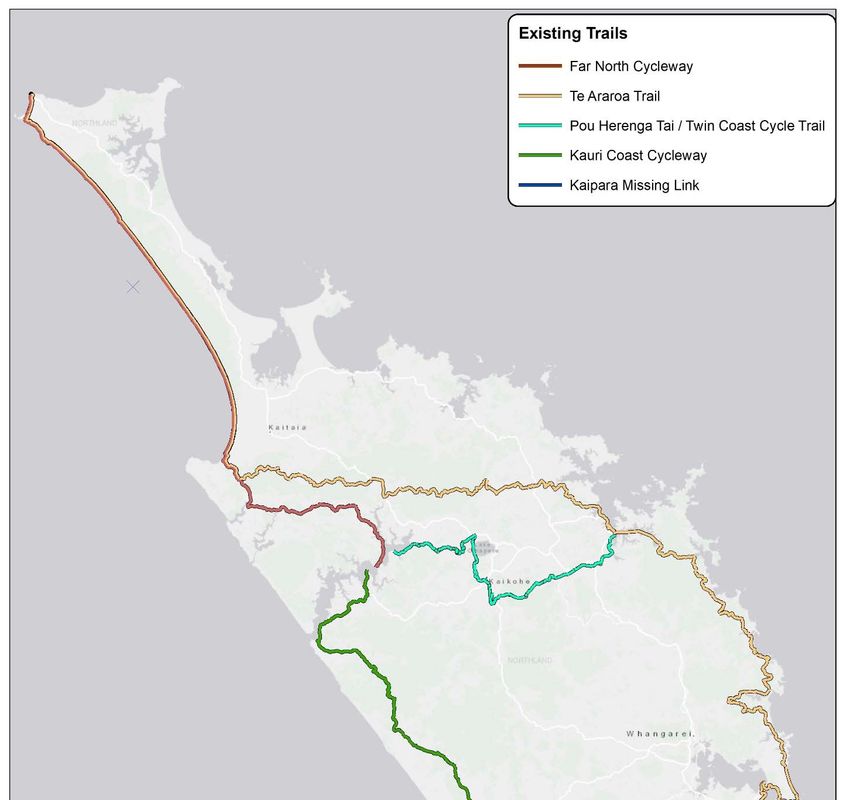
Figure 9. Northland Walking and Cycling Forum proposed structure ............................... 48

List of Maps
Map ES1: Existing and Proposed Regional Walking and Cycling Routes ............................ 9
Map 1: Existing Regional Walking and Cycling Routes ............................................................ 23
Map 2: Proposed Regional Walking and Cycling Projects ...................................................... 31
Map 3. Stage One of the Waipu to Waipu Cove Walking and Cycling Route................. 33
Map 4. Whangārei urban network ................................................................................................... 35

Acknowledgements

This strategy has been developed in close collaboration with the Regional Walking
and Cycling Steering Group. Northland Regional Council would like to thank the
following organisations for their assistance through the steering group:

                                                                 4
Whakatauaki

 Manaaki Tangata                         Providing for people
 Whakamua tatou                          Moving together
 Manaaki oranga                          Providing for health

Karakia

 Whakataka te hau ki te uru.             Cease the winds from the west.
 Whakataka te hau ki te tonga.           Cease the winds from the south.
 Kia mākinakina ki uta.                  Let the breeze blow over the land.
 Kia mātaratara ki tai.                  Let the breeze blow over the ocean.
 E hï ake ana te atakura.                Let the red-tipped dawn come with a
 He tio, he huka, he hau hū.             sharpened air.
 Tihei mauri ora.                        A touch of frost, a promise of a glorious
                                         day.
                                         Let there be life

Mihi

 E ngā iwi, e ngā mana, ka mihi ki a     All peoples, all authorities, our
 koutou katoa.                           acknowledgements to you all

 Ko tenei Rautaki, he Rautaki hou mo     This Strategy is a new strategy for our
 tatou rohe. E mahitahi ngā Kaunihera    region. The four Councils in Northland.
 tokowha kei roto i te rohe o            They have put their thoughts into this
 Taitokerau. Ka puta mai o ratou         strategy for the benefit of people,
 whakaaro mo te painga o te tangata,     supporting the well-being, moving
 tautokohia te oranga, e whakamua ngā    people and joining communities safely
 tangata, e Whakahono ngā hapori ki      through walking and cycling from Cape
 ngā hapori, e hīkoi, eke paihikara, e   Reinga to Kaiwaka and from Kaipara to
 haumaru nei, mai a Terenga Wairua tae   Whangārei.
 noa ki Kaiwaka, mai a Kaipara tae noa
 ki Whangārei.

 Tena koutou, tena koutou, tena tatou    Greetings to you, greetings to everyone.
 katoa.

                                         5
Executive Summary
The purpose of this strategy is to provide a strong tactical framework to support the
development and implementation of district council walking and cycling strategies,
and to place these within a regional context by identifying actions that can be taken
at a regional level.

The overarching vision for the strategy is:

       For Northland to be one of the world’s best coastal walking and cycling
       destinations where the journeys and stories are as impressive and
       memorable as the scenery.

The vision draws attention to the ‘coastal’ dimension of the region. Northland has the
longest readily accessible coastline in New Zealand with a total length of 3200km and
14 major harbours, including the Kaipara Harbour which is the largest harbour in the
Southern Hemisphere. It offers a real point of difference to the other regions of New
Zealand and internationally.

Walking and cycling is becoming an ever more important part of the transport mix.
The strategy recognises several prominent issues and opportunities relating to
walking and cycling in the region including: growing participation rates; the presence
of three nationally significant journeys; a lack of connectivity between infrastructure;
the importance of working together to develop and jointly fund new opportunities;
and the need to unlock the economic impact that walking and cycling creates in a
way that protects sensitive areas.

The strategy will assist in achieving the vision and responding to the issues and
opportunities by delivering on four strategic focus areas.

   1. Developing appealing and cohesive walking and cycling networks that
      connect Northland

   2. Growing walking and cycling participation and promoting Northland’s coastal
      point of difference

   3. Improving community wellbeing including creating economic opportunities

   4. Ensuring walking and cycling infrastructure, and its use, is sustainable

The first focus area emphasises the built infrastructure; the second concentrates on
the promotion of that product; the third reflects the desire to see that the
development bring benefits to Northlanders; and the fourth ensures that it is all done
sustainably.

A summary of the short and longer term actions to deliver each of the four focus
areas is outlined in the following diagram.

                                              6
Figure ES1. Summary of short term priorities

1. Cohesive                     2. Growing                    3.Community               4.Sustainable
 network                       participation                    wellbeing                    use
      a) Improve                     a) Develop
   infrastructure at            promotional material          a) Ensuring capacity
 pressure points, e.g.             emphasing our                and capability of            a) Establish the
  parking and toilets             'coastal' point of          Northland businesses        regional walking and
                                     difference               offering walking and         cycing forum with
   b) Enhance Pou                                                cycling related          representation from
  Herenga Tai/Twin              b) Multiple agencies                 services                     Maori
  Coast Cycle Trail1             co‐promoting our
                                many tracks and trails
c) Develop new multi‐           c) Encourage locals to                                   b) Continue to protect
   day experieinces               enjoy walking and                                      sensitive areas, tracks
                                 cycling in Northland                                           and trails
   d) Support the                                                 b) Continue to
development of local                                            improve walker and
                                 d) Attracting visiting
and urban networks2                                              cyclist safety and       c) Promote less used
                                 walkers, cyclists and
                                   mountain bikers                    security             walking and cycling
e) Connect Northland                                                                     areas, tracks and trails
   to Auckland via                                                                         and de‐emphasise
     Whangārei                  e) Work with Maori to                                       sensitive areas in
                                  enrich walking and                                       regional promotion
                                  cycling journeys by
f) Enhance nationwide             intertwining myths
 journeys: Te Araroa /                                                                    d) Work with Maori
                                      and stories.                                       utilising the principle
     Tour Aotearoa
                                                                                            of Kaitiakitanga
                                                               c) Engage local youth       (guardianship) to
                                      f) Targeted              / unemployed in track
g) Work with Maori as             engagement with                                        protect and manage
                                                               building or operations      trails sustainably
   key partners to                  Maori to grow
develop specific trails.         participation rates in
                                 walking and cycling.

                         Figure ES2. Summary of longer term priorities

1. Cohesive                     2. Growing                    3.Community               4.Sustainable
 network                       participation                    wellbeing                    use
                                                                                         e) Investigate options
                                                                                             for user pays to
                                                                                          support trails with
h) Improving coastal /                                                                   ongoing maintenance
harbour crossings on              g) Enable travel                 d) Celebrate
     key routes                    influencers to                achievements of           f) Monitoring and
                                promote the region's            walking and cycling         reporting use of
                                  walking & cycling            options to build local     walking and cycling
                                 options to others             awareness and pride       areas / infrastructure
   i) Support the
  development of                                                                            g) Review and
  mountain biking                                                                         improve progress
   opportunities                                                                         under this and other
                                                                                         walking and cycling
                                 h) Promote walking
                                                                   e) Investigate            strategies in
                                   and cycling as key
                                                               incentives and events          Northland
 j) Investigate other             reasons to visit off‐
                                                                for locals to bring a
     Heartland or                  peak (i.e. spring /
                                                                 visitor to a track /    h) Consider processes
      backcountry                autumn campaigns /
                                                                         trail           to establish custodial
rides/walks including                   events)
                                                                                           ownership where
unused rail corridors                                                                         appropriate

                                                          7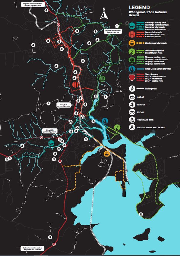
Notes:
1. The priorities outlined above may comprise multiple projects e.g. the Pou Herenga Tai-Twin Coast Cycle Trail has
potential projects to extend the trail at both ends and to connect with Ngawha Springs near Kaikohe.
2. The development of urban walking and cycling networks will occur at a district level. However, there will be
valuable regional opportunities for sharing resources and ideas.
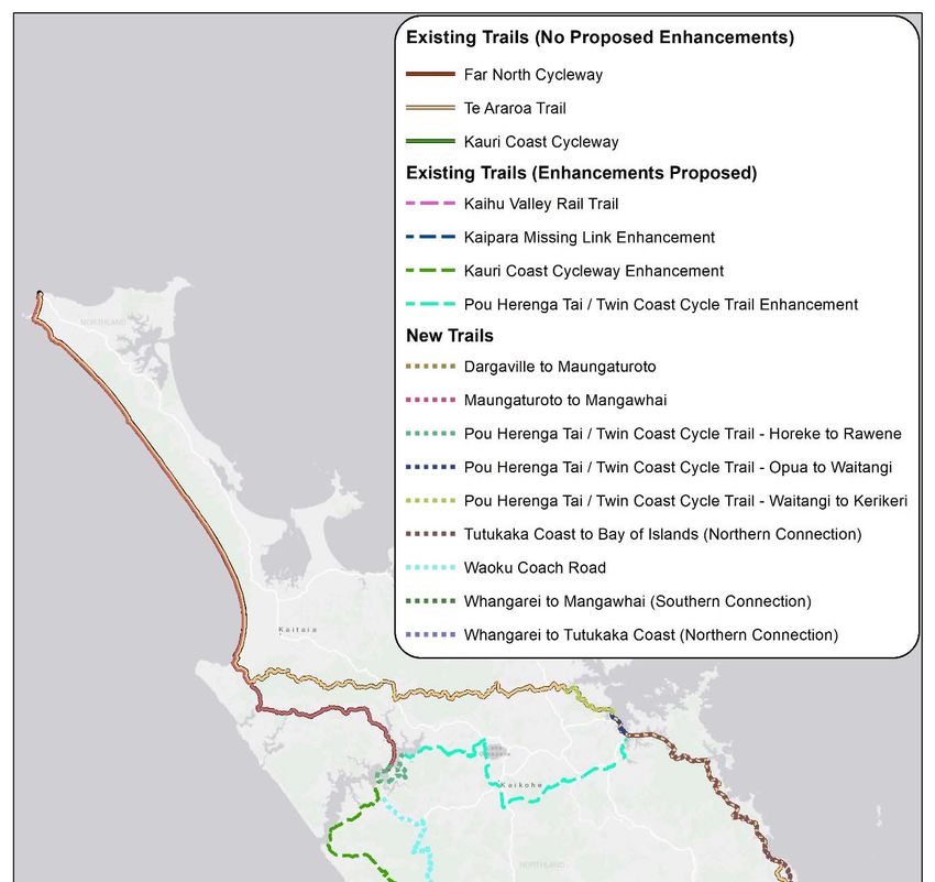
The region presently contains several long distance cycle trails:
The Pou Herenga Tai/Twin Coast Cycle Trail between Opua and Horeke
The Far North Cycleway from Cape Reinga to the Hokianga Harbour.
Kauri Coast Cycleway between Rawene and Dargaville.
Kaipara Missing Link from Dargaville to Pouto Point at the mouth of the Kaipara
Harbour and then by boat to Helensville.
The last three routes form part of ‘Tour Aotearoa’.
Northland is the northern starting point of the Te Araroa Trail, a walking route which
runs the entire length of the country from Cape Reinga to Bluff.
There are a large number of other scenic walks managed by DOC of varying length
and grades, as well as a series of short walks managed by district councils. DOC
manages a total of 119 tracks in Northland, representing 11% of all DOC tracks in
New Zealand.
Northland has a relatively small number of overnight or multi-day tracks, including
the Cape Brett Track and the Te Paki Coastal Track. None of these tracks are currently
designated as a ‘Great Walk’. Northland has a relatively high proportion of short
walks (93 tracks, equivalent to 13% of the total).
A number of new projects are proposed as part of this regional strategy that will
connect the region’s regional routes into a cohesive network. The below map
provides an overview of the proposed projects in the strategy combined with existing
regional walking and cycling routes.
8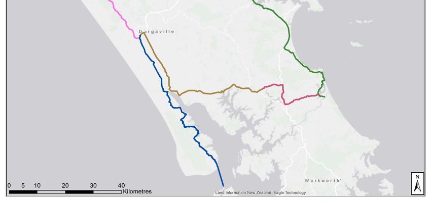
Map ES1: Existing and Proposed Regional Walking and Cycling Routes
Introduction
This is Northland’s first regional Walking and Cycling Strategy. Its development has
been overseen by a steering group made up of representatives from Northland
Regional Council (NRC) and Far North, Whangarei and Kaipara District Councils
(FNDC, WDC and KDC respectively) with input from the New Zealand Transport
Agency (NZTA), Northland Inc. Limited, the Department of Conservation (DOC), and
the New Zealand Walking and Access Commission (WAC).

The economic future of Northland relies on strong transport networks, and walking
and cycling are becoming ever more important to this mix. The region is one of the
least urbanised in New Zealand meaning there is a greater reliance on private car use
as well as a need to travel longer distances to reach places of employment, shopping,
leisure, health and education. Walking and cycling provide positive, enjoyable,
economic and healthy ways of getting around.

The strategy has been split into two sections. The first section comprises three parts
which set the context for this strategy. These three parts identify the key issues and
opportunities associated with walking and cycling in Northland; examine the
growing demand for walking and cycling; and outline the strategic framework
and linkages at the national, regional and district level within which the strategy lies.

The second section is broken into four parts, one for each of the four strategic
focus areas. Each of these parts includes a discussion of the current situation in
Northland with respect to the focus area, some of the potential opportunities that
could occur, and the specific actions or projects that can be undertaken.
A.1. Issues and opportunities
The Northland Walking and Cycling Strategy outlines a set of strategic focus areas
that will address the following issues and pursue relevant opportunities.

Joint funding will likely be required to build and upgrade our walking and cycling
infrastructure that links across district and regional boundaries. Focusing our limited
funding on the right projects will be key to generating the greatest overall impacts in
the medium to long term. Ongoing funding will be needed to maintain and improve
these assets.

There is a current lack of connectivity in walking and cycling infrastructure that
makes it difficult for people to use or reduces their appeal. Locals and visitors will
benefit from better connections between tracks and trails. These connections may
incorporate other modes of transport that make the journey more appealing and
enjoyable, e.g. a scenic boat ride or heritage train trip.

Northland’s unique geography presents an opportunity to celebrate our coastline
and harbours as people walk and cycle through the region. Northland’s coastal point
of difference can help set us apart from other destinations and provide richer journey
experiences that combine land and water based travel.

Another key advantage that Northland has over many other regions of New Zealand
is the presence of three nationally significant journeys within the region, i.e. Te
Araroa Trail walkway, Tour Aotearoa (bikepacking route) and a Great Ride (Pou
Herenga Tai/Twin Coast Cycle Trail) which forms part of Nga Haerenga, the New
Zealand Cycle Trail.

However, awareness of Northland as an iconic walking and cycling destination is low
compared to other regions in New Zealand.

Growing walking and cycling participation rates for Northland residents and visitors
to the region is likely to require a variety of interventions / activities targeted to a
range of ages and interest groups from local school children through to retired
visitors.

Northland’s current walking and cycling offerings vary widely in levels of use resulting
in pressure points on popular tracks and underutilised infrastructure elsewhere.
Consistently promoting a credible set of existing walking and cycling trails while
communicating where not to tread can help with protection of sensitive areas,
dispersal of visitors and asset utilisation.

It will be necessary to engage and enable businesses to unlock greater economic
impact through the provision of new products and experiences that will further
increase awareness and appeal of Northland as a walking and cycling destination.

Identifying innovative ways of working together to pursue new walking and cycling
development opportunities will be required in order to learn, leverage, share, save
and celebrate successes.

                                           11
A.2. Growing demand for walking and cycling
The most recent Active New Zealand survey (2017)1 carried out by Sport New Zealand
highlights just how popular walking and cycling is for New Zealanders. Walking is by
far the most popular sport and recreation activity undertaken by adults (aged 18
years and over) in both the last 12 months (85%) and the last 7 days (59%). Running
and jogging is third (38%) in the last 12 months while cycling is seventh (27%) in the
last 12 months.
Figure 1. Popular sport and recreation activities for New Zealanders
% Participation at least once in last 7 days and 12
months ‐ all adults (18+)
90
80
70
60
50
40
30
20
10
0
Last 7 days Last 12 months
Walking is the most popular activity whatever the gender. Cycling is generally more
popular for males.2
1
Sport New Zealand.– Findings from the 2017 Active New Zealand Survey.
2
These gender and age insights are supported by other research, such as Benchmarking
cycling and walking in six New Zealand cities: Pilot study 2015 by New Zealand Centre for
Sustainable Cities.
12Figure 2. Popular sport and recreation activities for New Zealanders by gender
% Participation at least once in last 7 days and 12
months walking and cycling categories ‐ adults (18+)
Male/Female
100
90
80
70
60
50
40
30
20
10
0
Walking Running/Jogging Road cycling, mountain Tramping
biking, BMX
Last 7 days Male Last 7 days Female Last 12 months Male Last 12 months Female
Walking remains popular across all age categories although running and jogging
rates fall off quite quickly with age. Cycling is most popular in the middle-aged
categories.
Figure 3. Popular sport and recreation activities for New Zealanders by age
% Participation at least once in last 12 months ‐ all adults
(18+) age categories
100
90
80
70
60
50
40
30
20
10
0
18‐24 25‐34 35‐49 50‐64 65‐74 75+
Last 12 months
Walking Running/Jogging Road cycling, mountain biking, BMX Tramping
In addition to these high domestic participation rates there are many international
visitors who chose to include walking and cycling while on holiday in New Zealand.
13Almost three-quarters (73%) of international visitors participated in walking / hiking
over the past three years – averaging 1.1 million visitors per year (Figure 4).
Figure 4. Walking and hiking participation rates for international visitors
Source: Tourism New Zealand, Special Interest Sectors Infographic, based on the MBIE International
Visitor Survey for the three years ended March 2017.
A smaller number, 9% of international visitors, participated in cycling during the past
three years – an average of 138,000 visitors per year. Australia is the largest market
for cycling experiences in New Zealand (Figure 5).
Figure 5. Cycling participation rates for international visitors
Source: Tourism New Zealand, Special Interest Sectors Infographic, based on the MBIE International
Visitor Survey for the three years ended March 2017.
It is important to consider the various users of cycling and walking infrastructure,
and the underlying trends in each segment of the market (Table 1).
Table 1. Growth trends by type of walker and cyclist
Walker types Current Trends
School / commuter Stabilising after long-term decline
Short walks Growing
Day walks Growing
Multi-day walks Growing
Epic walkers, e.g. Te Araroa Growing but very small numbers
Cyclist types
School / commuters Stabilising after long-term decline
Local recreational riders Growing
14Easy off-road trails Growing
Avid mountain bikers Growing
Active riders wanting multi-day adventures Growing
Bikepacker (combining biking and camping) Growing but very small numbers
While there is a growing trend towards more walking and cycling, the type of
activities/experiences sought is shifting gradually in line with changing
demographics, values and attitudes, and trip characteristics. For example, visitors
generally have less time and outdoor experience than previously. They want to
engage physically with the outdoors but in a way that is easily accessible in terms of
location and commitment. They seek short, easily accessible soft adventure activities,
escaping from the everyday through nature-based experiences. Another trend to
follow is the adoption rate of electric bikes that is drawing more people into cycling
and mountain biking by effectively removing the need for hard uphill riding.
Further research is required to better understand these trends and how they relate to
Northland so that the region can benefit from the growth trends in people walking
and cycling from New Zealand and around the world.
A.3. Strategic framework and linkages
The Northland Walking and Cycling Strategy provides a link between nationally
relevant strategies and agencies, regional initiatives, and plans at a district level
(Table 2).
Table 2. Linkages with national, regional and district strategies and plans
National Regional District
o The Government Policy o The Northland o Whangarei District
Statement for Land Regional Land Council’s Walking and
Transport Funding is Transport Plan (2015- Cycling Strategy 2018
produced by the 2021) sets out the (draft) provides the
Ministry of Transport. It overall regional land detail for a
sets the priorities for transport priorities. This comprehensive set
central government land includes a strategic walking and cycling
transport funding. priority to increase initiatives within the
o The New Zealand travel choices and to district and how these
Transport Agency improve participation in will link with other areas
(NZTA) is a key partner walking and cycling, and o The Kaipara Walking
and funding agency for to promote connections and Cycling Strategy
transport projects across between walking, 2017 outlines plans for
Northland cycling and public the district to become a
o The Ministry of transport walking and cycling
Business Innovation o The Tai Tokerau destination
and Employment Northland Economic o Work is underway on a
(MBIE) funds economic Action Plan provides a walking and cycling
and regional strategic framework for strategy for Far North
development including regional economic and District and an
cycle trail development tourism development Experience and Product
Development Plan for
15o The Department of o Northland Forward Pou Herenga Tai-Twin
Conservation (DOC) Together is the Coast Cycle Trail
administers Great Walks, collective plan for all
Short Walks and Day four Northland councils
Hikes in its role as to work together to
custodian for New deliver better outcomes
Zealand’s public for Northland and its
conservation land people
o The New Zealand
Walking Access
Commission is a Crown
entity that protects and
promotes free, certain,
enduring and practical
access to the outdoors
o Nga Haerenga, The
New Zealand Cycle
Trail Inc. is focused on
growing New Zealand
through outstanding
cycling experiences
The following paragraphs describe in more detail some of these strategies, plans and
funding sources.
Government Policy Statement for National Land Transport Funding
The Government Policy Statement (GPS) sets the priorities for central government
land transport funding for a period of ten years. A new GPS for the period 2018/19 –
2027/28 (GPS 2018) was released in June 2018.3 Relevant objectives and results
identified for walking and cycling are shown in Table 3.
Table 3. Walking and cycling objectives and results in GPS 2018
Strategic Objective Long term (10+ Short to medium term
Priorities year) results results (3-6+ years)
A land transport
Significant reduction
system that is a safe
Safety in deaths and serious Cycling and walking is safer
system, free of death
injuries
and serious injury
A land transport Metropolitan and A more accessible and
system that provides high growth urban better integrated transport
Access increased access to areas are better network including public
economic and social connected and transport, walking and
opportunities accessible cycling
3
https://www.transport.govt.nz/multi-
modal/keystrategiesandplans/gpsonlandtransportfunding/
16Improved good-quality, fit-
for-purpose walking and
cycling infrastructure
Improved real and perceived
safety for both pedestrians
Increased mode shift
A land transport and cyclists
from private vehicle
system that enables Increased proportion of
trips to walking,
transport choice and journeys made using public
cycling and public
access transport and active modes
transport
of travel
Expanded and better
connected walking and
cycling networks both in
urban and rural areas
A land transport
system that reduces
Reduce transport’s Increased uptake of active
greenhouse gas
negative effects on travel modes such as
emissions, as well as
Environment the local walking and cycling to
adverse effects on
environment and support environmental and
the local
public health public health objectives
environment and
public health
Source: Government Policy Statement on Land Transport, 2018/19 – 2027/28
The GPS provides a quantum of funding towards walking and cycling projects based
on a range (upper and lower band). The proposed annual funding range for walking
and cycling projects (including capital expenditure and promotional activities) in the
ten-year funding period from 2018 to 2028 is as follows:
Table 4. Annual funding for walking and cycling in GPS 2018, 2018-2028
Year 18/19 19/20 20/21 21/22 22/23 23/24 24/25 25/26 26/27 27/28
Range $60- $80- $95- $80- $75- $75- $75- $75- $75- $80-
($M) $95 $120 $145 $125 $115 $115 $115 $115 $115 $120
Source: Government Policy Statement on Land Transport, 2018/19 – 2027/28
NZTA has the responsibility of allocating funding through the National Land
Transport Programme within this funding range. This funding can be allocated to
walking and cycling projects if put forward by district councils through the Regional
Land Transport Plan (see below).
Northland Regional Land Transport Plan (2015-2021)
The Northland Regional Land Transport Plan is the region’s “joint” bid for funding
assistance from the National Land Transport Fund (NLTF). It includes land transport
projects put forward by district councils and NZTA, and the public transport
programme put forward by the regional council. Councils can bid for a share of the
NLTF based on the overall strategic fit of projects with funding criteria. Unless
17funding assistance is provided at 100% national funding, a local share for a project is
usually necessary.
Dedicated Funding Streams
There are two specific national funding sources that can be accessed for walking and
cycling projects separate to the NLTF.
Urban Cycleways Programme
A $100 million fund to be spent between 2015/16 – 2017/18 on cycling infrastructure
in main urban centres thought New Zealand. WDC received $3.5 million ($2 million
from the Urban Cycleways fund and $1.5 million from the NLTF) to develop the Kamo
shared walking and cycling path in the city with a total cost of $4.8 million.
National Cycleway Fund
The National Cycleway Fund, established in 2009, supported the establishment of an
initial 19 Great Rides that formed Nga Haeranga, the New Zealand Cycle Trail. Three
existing trails were subsequently granted Great Ride status, taking the total to 22
Great Rides throughout New Zealand. An additional $25 million over four years was
announced at Budget 2016 for the next phase of the New Zealand Cycle Trail. The
Pou Herenga Tai/Twin Coast Cycle Trail was developed partly through funding from
this fund.
Other Funding Streams
Provincial Growth Fund
The Provincial Growth Fund, announced by the Labour Government in 2018, aims to
lift productivity potential in the provinces. Its priorities are to enhance economic
development opportunities, create sustainable jobs, enable Māori to reach their full
potential, boost social inclusion and participation, build resilient communities, and
help meet New Zealand’s climate change targets.
All provinces are eligible for funding, however, Tairāwhiti/East Coast, Hawke’s Bay, Tai
Tokerau/Northland, Bay of Plenty, West Coast and Manawatū-Whanganui have been
identified for early investment. The fund has three investment tiers:
1. Regional projects and capability: Support of economic development projects,
feasibility studies and capability building identified by the regions.
2. Sector investment (including One Billion Trees programme): Investment in
initiatives targeted at priority and/or high value economic opportunities.
3. Enabling infrastructure projects: Investment in regional infrastructure projects
that will lift productivity and grow jobs.
Tourism Infrastructure Fund
Provides $25 million per year for the development of tourism related infrastructure
such as car parks, freedom camping facilities, sewerage, water works and transport
18projects. Although not specifically aimed at walking and cycling development,
councils can access the fund to develop complimentary facilities in areas subject to
growth pressure from tourists.
Investment and Growth Reserve
NRC maintains an Investment and Growth Reserve (IGR) to enable it to make
strategic investments that lift the long-term growth of the Northland economy. The
IGR is funded by an annual input of $1.7 million from council’s investment income
with additional transfers from the Community Investment Fund to both inflation-
proof this annual input and to top-up the IGR if needed to support economic
development opportunities that arise. The IGR is used to provide operational funding
to Northland Inc., fund business case assessments and invest in projects that meet
the eligibility criteria.
New Zealand Walking Access Commission
The New Zealand Walking Access Commission (WAC) is the Crown entity that plays a
lead role in protecting natural heritage by promoting free, certain, enduring and
practical access to the outdoors.
WAC has indicated their support of future development of tracks and trails in
Northland. This support could range from:
assisting in understanding unformed legal roads and access ways
assessing the relative merits of proposed walking or cycling tracks
tapping into the expertise of their experienced team to optimise or add value
to potential projects as they are scoped
providing independent advice on regional and / or track and trail narrative
development to ensure the Northland story and point of difference is being
conveyed
Tai Tokerau Northland Economic Action Plan
The Tai Tokerau Northland Economic Action Plan (TTNEAP) contains more than 50
actions to coordinate economic development in Northland. The development of the
action plan was overseen by a steering committee of district councils, the regional
councils and government agencies. The logistics and transport infrastructure
workstream includes several relevant projects to walking and cycling: This includes:
Connecting Northland – a roading project that will connect Auckland to
Whangārei in several stages. An opportunity exists to incorporate walking and
cycling into the project.
19 Twin Coast Discovery Route Upgrade – improving bridges, layovers and
byway signage. Walking and cycling is likely to form part of the package of
initiatives.
District Walking and Cycling Strategies
Though non-statutory documents, district councils may choose to develop walking
and cycling strategies as a way of expressing a proposed walking and cycling
programme. Currently two district councils in the region have walking and cycling
strategies which have either recently been reviewed (KDC) or are in the process of
being reviewed (WDC). FNDC is working to develop one.
20B. Strategic Focus Areas
There are four strategic focus areas that seek to balance growth in the supply of
facilities and services with the increasing demand from users within Northland and
visitors from outside the region including overseas travellers. The foundation for this
balanced growth will be increasingly connected and safer communities across
Northland and enabling businesses to benefit in ways that are sustainable.
Figure 6. Four focus areas of the Northland Walking and Cycling Strategy
ONE: Developing appealing and cohesive TWO: Growing walking and cycling
walking and cycling networks that connect participation and promoting
Northland Northland's coastal point of difference
FOUR: Ensuring walking and cycling
THREE: Improving community wellbeing
infrastructure, and its use, is
including creating economic opportunities
sustainable
B.1. Focus Area One: Developing appealing and cohesive
walking and cycling networks that connect Northland
This focus area sets out the walking and cycling “hardware” needed for Northland. It
is divided into four parts: the development of a regional network, local routes, urban
networks, and mountain bike opportunities.
Development of a regional walking and cycling network
Northland is a region where tourism is of increasing importance. Tourism provided
approximately 8800 jobs in 2017, almost 13% of total jobs in the region (9%
nationally). Over $1 billion was spent in the region including $783 million domestic
spending and $278 million international spending4.Tourism related expenditure has
been growing by 10% per annum over the past three years.
At present, walking and cycling is not a prime drawcard for visitors to the region. A
quality regional network will encourage an uptake in domestic and international
walking and cycling tourism in Northland, increase visitor spending and extend the
time visitors spend in the region. The development of a regional network will also
align with projects included in the TTNEAP such as the revitalisation of Twin Coast
4
Northland Region Economic Profile, https://ecoprofile.infometrics.co.nz/Northland+Region.
21Discovery Route and the development of scenic byways known as Northland
Journeys. The walking and cycling projects identified in this strategy will, when fully
developed, create a cohesive regional network. This will include a mix of:
Walks – from short half-day walks to multi-day hikes.
Easy Rides – these are rides for the recreational and casual cyclist and
comprise mostly grade 1 and some grade 2. They include what are termed as
‘Great Rides’.
Avid Rides – these are rides for the more intrepid and adventurist cyclist and
will comprise anything that is grade 3 or higher. These will include rides that
are on and off road.
Opportunities should be taken to enable, where possible, walkers and cyclists to
jointly use the infrastructure, thereby ensuring a greater target audience and use.
22Map 1: Existing Regional Walking and Cycling Routes
Current state of the regional walking network

Northland is the northern starting point of the Te Araroa Trail which runs the entire
length of the country from Cape Reinga to Bluff (Map 1).5 The trail in Northland uses
a mix of beaches, paper roads, existing tramping tracks on public land and some
crossing of private land. It follows the same route as the Far North Cycleway along
Ninety Mile Beach (Te Oneroa-a-Tōhē) before heading eastwards across to Kerikeri
through several Northland forests. From there the trail follows a route close to the
western seaboard of the region. Some parts of the trail are quite challenging for
casual walkers, although the trail is not intended for this purpose. Trail development
has been driven by the Te Araroa Trust with financial assistance from funding
partners such as DOC.

There are a large number of other scenic walks managed by DOC of varying length
and grades, as well as a series of short walks managed by district councils. These
provide visitors with access to stunning viewpoints and culturally significant locations
throughout the region. DOC manages a total of 119 tracks in Northland, representing
11% of all DOC tracks in New Zealand (Table 5).

              Table 5. DOC managed tracks in Northland and New Zealand
                                   Northland                    New Zealand           Northland as
                               Number      % total          Number       % total        % of NZ
Short (under 4 hours)             93          78%              699          62%            13%
Day (over four hours)             22          18%              274          24%             8%
Overnight / Multi‐day              4           3%              157          14%             3%
Total                            119         100%            1,130        100%             11%

Source: Department of Conservation, https://www.doc.govt.nz/parks-and-recreation/things-to-
do/walking-and-tramping/

Northland has a relatively small number of overnight or multi-day tracks, including
the Cape Brett Track and the Te Paki Coastal Track. None of these tracks are currently
designated as a ‘Great Walk’.

On the other hand, Northland has a relatively high proportion of short walks (93
tracks, equivalent to 13% of the total). These include the Tokatoka Scenic Reserve
Track and Tutukaka Head tracks. The region has two of the 14 nationwide “Best Short
Walks” promoted by DOC – Mt Manaia Track and Mangawhai Cliffs Walkway. It is
also home to one of the five nationwide “Best Day Hikes” identified by DOC – Te
Whara Track (Bream Head). These were part of a new initiative announced by the
government in September 2017. Northland tracks feature on the front cover of both
the “Best Short Walks” and “Best Day Hikes” brochures.

DOC have a work programme in place to improve specific tracks and experiences
over the next two years. These include the Cape Brett redevelopment, the
Ruapekapeka pa and battle historic site (to be completed by January 2021), and the

5
    https://www.teararoa.org.nz/.
Bream Head tracks. DOC is also working towards redeveloping the Tane Mahuta
experience in Waipoua Forest.
Opportunities to enhance the regional walking network
Enhance the Te Araroa Trail
The trail is of national significance and many people choose to start their journey at
Cape Reinga meaning Northland is the first impression that walkers get when using
the trail. The growing popularity of the trail and the fact that it crosses large parts of
the region present an opportunity to improve the facilities on the route and overall
visitor experience. Improvements could include access to the trail itself, signage,
parking and toilets. Dedicated funding streams such as the PGF and the TIF provide
opportunities for district councils and other groups such as the trail trust to apply for
funding. These improvements should be coordinated with DOC’s programme of work
to ensure the most efficient coverage.
Investigate opportunities to develop new multi-day walks
DOC announced in 2017 that they were accepting proposals for new Great Walks.
The Te Paki Coastal Track is currently being considered by DOC as one of seven
proposals to be designated as a new Great Walk in the North Island. Should this
progress, it will be a significant drawcard for tourists to the region, particularly given
the proximity of this walk to Auckland compared to other existing Great Walks.
Rather than building a new multi-day track, an alternative is to “join up” in a
promotional way existing short and day tracks in the region to present viable multi-
day walking options. This could build on district council, DOC and other tracks and
trails located in the region.
Current state of the regional cycling network
The Pou Herenga Tai-Twin Coast Cycle Trail between Opua and Mangunga is the
region’s only Great Ride (one of 22 nationwide), forming part of Nga Haerenga, The
New Zealand Cycle Trail.6 The 87km long trail provides a safe, largely off-road route
that is divided into four sections. It can be completed over several days of travel and
ridden all year round. The trail is suitable for most riders as it is generally flat with
gentle climbs - most of it being grade 1 and 2, with one section a grade 2-3.
The region has a developing network of Heartland Rides (Map 1). Heartland Rides
function as back country cycle touring routes (mainly on-road) linking the Great Rides
(mainly off-road trails), urban centres, transport hubs and other key tourist
attractions. There are three Heartland Rides in Northland:
Far North Cycleway – this 161km Heartland Ride runs along Ninety Mile Beach
(Te Oneroa-a-Tōhē) from Cape Reinga to Ahipara and then along quiet rural
roads to the north side of the Hokianga Harbour.
6
https://www.nzcycletrail.com/.
25 Kauri Coast Cycleway – this 113km Heartland Ride links Rawene on the
Hokianga Harbour though to Dargaville. This route mainly uses SH12, and
passes through kauri forest and secluded coastal settlements.
Kaipara Missing Link – this 118km Heartland Ride joins Dargaville with central
Auckland. The route heads southwest from Dargaville to the holiday village of
Pouto Point at the mouth of the Kaipara Harbour. The “missing link” to this
cycle tour involves a boat trip across the Kaipara Harbour. The trail then follows
a surprisingly gentle route into the very centre of Auckland.
Together these three routes link Cape Reinga with Pouto Point along the west coast
of Northland and form the first 400km of the developing ‘Tour Aotearoa’ route from
Cape Reinga to Bluff (3000km).7 Tour Aotearoa has grown to attract 600 riders in
2018 and is rapidly growing as a ‘bikepacking’ route attracting many overseas riders.
Northland’s existing Heartland Rides currently appeal to ‘strong and fearless’ and
‘enthused and confident’ cyclists who are comfortable travelling longer distances on
the state highway network and/or gravelled roads relatively far from townships. The
Pou Herenga Tai/Twin Coast Cycle Trail on the other hand provides a higher level of
service, suitable for all riders, with the route mostly off road or alongside road, closer
to townships and services. Other areas of the region, particularly the east coast,
popular with visitors, are poorly served by cycling routes.
The TTNEAP includes amongst its projects, a plan to revitalise the Twin Coast
Discovery Route (in both the Transport / Logistics and Visitor Industry work streams).
The Twin Coast Discovery Route is an 800km touring route around the Northland
Region starting in the Auckland Region. NZTA and Northland Inc. have partnered to
develop a Programme Business Case (PBC) to collaboratively address this. The PBC
considers the case for investment to address problems on the Twin Coast Discovery
Route to encourage visitors and locals to get off the beaten track, to visit new places,
try new experiences and stay longer in Northland.
The PBC identifies a number of options and initiatives to achieve these outcomes.
Cycling is an emerging visitor activity in Northland and has the potential to generate
economic benefits for the region. Accordingly, cycling connections are an important
component of the PBC preferred programme with recommended options including
extensions to existing cycling paths, linking to other attractions and the creation of
new infrastructure.
Northland Inc. and NZTA have worked with local authority partners to develop a
series of byways around the region that form a set of Northland Journeys.8 The
thematic journeys function as offshoots of the main touring route and are road based
journeys primarily for vehicles although could be used by cyclists. Northland Journeys
include:
7
http://www.touraotearoa.nz/p/home.html.
8
https://www.northlandnz.com/visit/northland-journeys/.
26 Where Giants Gather – the journey from Whangarei Town Basin to the
Whangarei Heads
Ancient Kauri Trail – from Paparoa to Omapere
Into the Wide Blue Yonder – from Whangarei Falls to Tutukaka and on to
Hikurangi
Te Ara (Coast to Coast) – connecting Waitangi with Omapere including
Horeke and Rawene
The Secret Coast (Old Russell Road) – from Whakapara on SH1 (Oakura
turnoff) to Russell
All About Islands – a set of water based journeys encouraging visitors to visit
an island in the Bay of Islands.
Opportunities to enhance the regional cycling network
Enhancing the Pou Herenga Tai-Twin Coast Cycle Trail
Further development of the Pou Herenga Tai-Twin Coast Cycle Trail from a visitor
experience perspective is now possible given the physical trail has been completed.
For example, itineraries that combine cycling with cultural experiences such as marae
meals and stays, and/or create linkages with other transport modes, such as catching
a steam train from Opua to Kawakawa or a steam boat from Horeke to Kohukohu,
will make this journey even more interesting and enjoyable, and maximise the
economic returns and social benefits for the communities along the route.
There are also opportunities to extend the trail at both ends. At the western end, the
trail could connect the Mangungu Mission House to Rawene via a bridge over the
Takeke River. This 24km project would comprise a ridgeline grade 2 unsealed road
trail with spectacular vistas, connecting the trail to west coast facilities and
attractions. It would also create a link with the Kauri Coast Cycleway onwards to
Opononi. At the eastern end, there is an opportunity to extend the trail through to
Waitangi, and eventually on to Kerikeri. Extending the trail by 8km from Opua
through to Waitangi would complete the initial trail concept of linking the two initial
signing grounds of the Treaty of Waitangi / Te Tiriti o Waitangi.
Connecting Auckland to Northland via Whangārei
The existing network of three Heartland Rides focusses on joining up sections of
Northland’s west coast. Future improvements to the state highway network between
Auckland and Whangārei creates opportunities to better link the east coast of the
region with Auckland for walkers and cyclists as well as motor vehicles. These include
the improvements to the roading network around the Hibiscus Coast proposed by
Auckland Transport, the currently under development Puhoi-Wellsford Road of
National Significance, and any future improvements north to Whangārei. Whilst
consideration of walking and cycling provision in tandem with any programmed
roading improvements is important, it is also necessary to understand the type of
offering that users want. Visitors who wish to access Northland’s coastline or want a
quieter experience are unlikely to find much appeal in a route wholly parallel to a
state highway.
27Auckland Transport are working with community cycling groups in the former
Rodney District to connect the Hibiscus Coast with Wellsford and ultimately
Northland. The route is likely to be on lightly travelled roads hugging the east coast.
This presents an opportunity to create a Heartland Ride spanning the length of
Northland’s east coast from Auckland to Whangārei. To be viable, the connection to
the Northland network will likely need to be at Mangawhai which could be an
extension of a local initiative to develop an off-road cycleway between Waipu and
Waipu Cove. The mix of quieter routes near Northland’s coastline combined with
some utilisation of off-road sections near upgraded state highway corridors, where
appropriate, may have broad appeal to visitors.
Connecting Whangarei to Bay of Islands via the East Coast
Cyclists wishing to cycle from Whangārei to the Bay of Islands (Opua, Paihia and
Russell) currently have two choices – they can travel up SH1 or use the Old Russell
Road. SH1, though more direct, carries a higher volume of traffic including heavy
vehicles and therefore can present an intimidating option to cyclists. The Old Russell
Road on the other hand is more lightly trafficked and provides scenic rest stop
opportunities. However, it currently provides little in the way of dedicated cycling
infrastructure. Directly east of Whangārei is the Tutukaka Coast, part of the Twin Coast
Discovery Route, but with no direct cycleway connection. Exploratory work, led by
WDC, is underway to connect Whangārei to Ngunguru with a formal cycleway
connection. This could provide a logical entry point to a heartland ride running up the
east coast from Whangārei to the Bay of Islands.
Utilisation of redundant rail corridors
Northland has a number of rail corridors that are no longer in use or have been
‘mothballed’ by Kiwirail. Some of these are currently being utilised by cycleways – for
example part of the Pou Herenga Tai/Twin Coast Cycle Trail is on an old track bed.
Additionally, the Kamo urban cycle route follows the operational rail corridor through
Whangārei. The changing rail landscape in Northland does present a number of
opportunities, including:
The development of the Kaihu Valley River Cycle Trail (Dargaville to Donnelly’s
Crossing) as a Great Ride via the redundant rail corridor. This could also become
part of the Kauri Coast Cycleway, making this Heartland Ride more user friendly
and catering to a broader visitor group.
The possibility of connecting Dargaville to Whangarei via the currently
disused rail corridor (a branch of the North Auckland line) if and when the
railway line becomes available. A decision on the decommissioning of the
railway line is still to be decided and as such this is not an immediate priority.
A distinctive on-rail cycling experience may also be an option on some
sections of the railway track.
Repurposing the mothballed North Auckland line north of Kauri for walking and
28cycling, providing a direct route from Whangarei to Kawakawa and the Pou
Herenga Tai-Twin Coast Cycle Trail. Again, this is dependent on any plans to
decommission the line by Kiwirail and therefore is not an immediate priority.
North Kaipara Harbour Heartland Ride
There is currently no formal route connecting the west and east coasts of Northland
south of the Pou Herenga Tai/Twin Coast Cycle Trail. North of the Kaipara Harbour,
recreational cyclists can use SH12. However, this road is subject to relatively high traffic
volumes including heavy vehicles. The development of a route from Dargaville to
Mangawhai, could better connect townships and features in between such as the
Matakohe Kauri Museum and Tokatoka Peak, using off-road routes and low volume
roads. The project could capitalise on sections where existing walking and cycling
projects are gaining momentum (for example at the Matakohe Bridges realignment
and use of Ruawai Stopbanks) to ensure connectivity. The project could connect
Dargaville to Maungaturoto and then onwards to Mangawhai.
Developing off-road or low volume road alternatives to existing Heartland Rides
Northland as a relatively sparsely populated region has a number of coach roads and
other back roads with low traffic volumes. These can provide alternatives to cyclists
who would prefer not to use state highways or more heavily trafficked local roads.,
Existing heartland rides in Northland appeal to the ‘strong and fearless’ cyclist. Using
alternative routes such as coach roads will appeal to other types of recreational cyclist
such as young families or older riders. They also present an opportunity to showcase
Northland’s landscape away from the state highway network.
An immediate opportunity worthy of further exploration exists with the Waoku Coach
Road to the east of the Waipoua Forest. This would provide a logical extension to the
potential Kaihu Valley River Cycle Trail and provide an alternative route for the Kauri
Coast Cycleway which currently uses SH12 through the Waipoua Forest. This could
potentially link up with the Pou Herenga Tai-Twin Coast Cycle Trail where the coach
road joins with the Kauri Coast Cycleway east of Opononi. This would provide a trail
experience linking Northland's key attractions.
A further opportunity is providing a safer off-road alternative to the Kauri Coast
Cycleway as it runs between Rawene and the popular tourist attraction of the Waipoua
Forest (currently the cycleway runs concurrent with SH12).
Enhancing existing connections from Auckland to Northland via the Kaipara Harbour
The Kaipara Missing Link connects Helensville (and by extension Auckland) with Pouto
Point where the route continues north to Dargaville via Pouto Road. This section could
be enhanced by increasing the frequency and dependability (i.e. a fixed season) of ferry
services across the harbour and improving wharf infrastructure at Pouto. An additional
ferry service to Pahi, Ruawai or Matakohe from Helensville, bypassing the longer leg of
the Missing Link Cycleway on the Pouto peninsular is also a possibility.
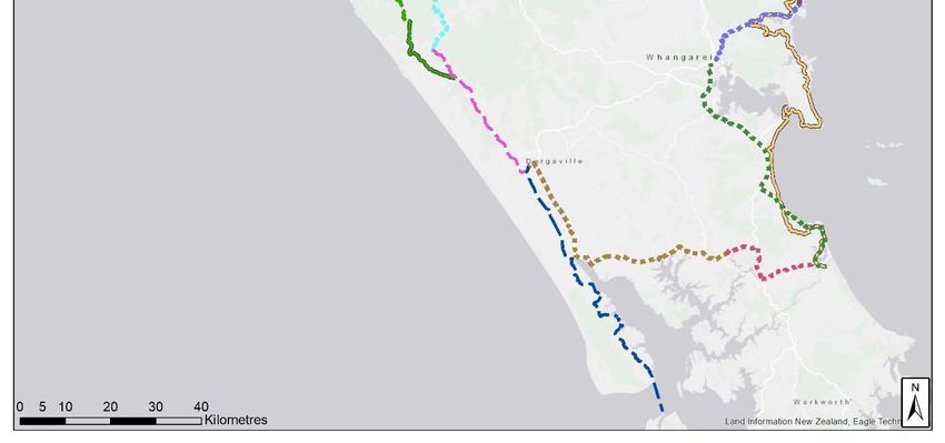
29The table and map below provides an overview of the priority regional projects in the
strategy. Please note that each cycling project listed below can also be used as a
walking track.
Table 6: Proposed Regional Walking and Cycling Projects
Project name Length Likely Grade Strategic benefits
(kms)
Pou Herenga Tai | Twin 8 1/3 Extension east of Great Ride
Coast Cycle Trail - Opua to to popular visitor
Waitangi attractions
Pou Herenga Tai | Twin 87 1 (some 2) Enhances visitor experience
Coast Cycle Trail on an existing Great Ride
Enhancement
Pou Herenga Tai | Twin 24 1/3 Extension west of Great
Coast Cycle Trail - Horeke Ride to Kauri Coast
to Rawene Cycleway Heartland Ride
Whangarei to Mangawhai TBD (≈70) 1/3 Part of long distance
(Southern Connection) connection of Whangarei
with Auckland and Bay of
Islands.
Whangarei to Tutukaka 55 1/2 (some 3) Part of long distance
Coast (Northern connection of Whangarei
Connection) with Auckland and Bay of
Islands.
Pou Herenga Tai | Twin 19 1/2 Extension east of Great Ride
Coast Cycle Trail - Waitangi to popular visitor
to Kerikeri attractions
Kaihu Valley Rail Trail 40 1 (some 2) Off road alternative for
existing Heartland Ride.
Dargaville to Maungaturoto 90 2/3 Part of the connection of
the east and west coasts in
southern Northland. Will
help provide a ‘loop’ of the
region.
Maungaturoto to TBD (≈30) 3 Part of the connection of
Mangawhai the east and west coasts in
southern Northland. Will
help provide a ‘loop’ of the
region.
Tutukaka Coast to Bay of TBD (≈90) 3 Part of connection of
Islands (Northern Auckland, Whangarei with
Connection) Bay of Islands
Kauri Coast Cycleway 37 / 45 3 Off road alternative for
Enhancement (Rawene to existing Heartland Ride.
Tane Mahuta)
Waoku Coach Road 50 4 Off road alternative for
existing Heartland Ride.
Kaipara Missing Link 59 3 Off road alternative for
Enhancement existing Heartland Ride
(through new ferry
services).
30Map 2: Proposed Regional Walking and Cycling Projects
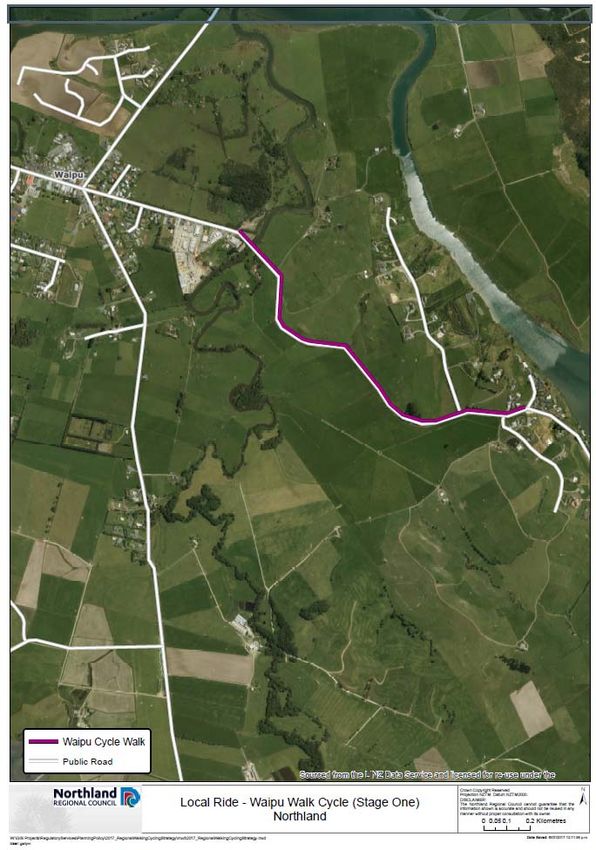
Development of local routes

The second part of focus area one recognises that developing local routes are also
important. These routes will more safely connect local communities to access
education and employment opportunities as well as provide health and
environmental benefits.

Current state of local district walking and cycling routes

Currently the off-road network of local walking and cycling routes in Northland is
limited (with the exception of the Whangarei Urban area which is addressed
separately). Communities for the most part use the local roading or state highway
network when travelling by bike. Footpaths are also used. However, this is illegal
under the NZ road code unless designated as a shared path. Frequently, submitters
to councils cite a ‘hostile walking and cycling environment’ as a barrier to use. This
includes having to share the road with fast moving traffic as well as complaints about
the roads themselves being narrow and winding.

District councils are increasingly being more proactive in helping communities to
develop short local routes that connect rural areas with employment and recreational
opportunities. Local community groups, with district council support, are establishing
to advocate, and in some cases project manage, the development of walking and
cycling routes.

A good recent example is the Waipu to Waipu Cove walking and cycling track
developed by the Waipu Cycling and Walkway Trust (Map 3). The Waipu community
raised funds for this project with donations of money, materials and volunteer hours
from local business and residents as well as the gifting of private land.
Map 3. Stage One of the Waipu to Waipu Cove Walking and Cycling Route
Future opportunities for local district walking and cycling routes
District councils can partner with local communities to help fundraise and develop
off-road and enhanced on-road walking and cycling routes. There are significant
opportunities to better connect communities, particularly those with growing
populations in relatively close proximity. Other examples of where local routes could
be improved include:
Whangarei to Whangarei Heads
Mangawhai to Mangawhai Heads
Taipa, Cable Bay, Coopers Beach and Mangonui
Marsden Point, One-Tree Point and Ruakaka
Links between the Kauri Coast Cycleway (and future Kaihu Valley Rail Trail)
and Kai Iwi Lakes
Although off-road routes are usually the preferred solution, a package of measures
including traffic calming, signage, speed restrictions and road markings can enhance
the environment for on-road cycling particularly where there are constraints around
33You can also read