Management of Earthquake Risk by Canterbury Regional Council and Christchurch City Council - Obligations and Responses under the RMA
←
→
Page content transcription
If your browser does not render page correctly, please read the page content below
ENG.ENF.0001.1

Management of Earthquake Risk by
  Canterbury Regional Council
                    and
     Christchurch City Council

  Obligations and Responses under the RMA

          Enfocus Ltd, November 2011
ENG.ENF.0001.2

Contents
1     Introduction ......................................................................................................... 1
    1.1    Matters not in scope ..................................................................................................... 1

2     Natural hazards planning obligations under the Resource Management Act
3     Best practice in natural hazards planning........................................................ 2
4     Environment Canterbury planning response................................................... 2
    4.1    Regional Policy: The Regional Policy Statement......................................................... 2
    4.2    Related regional council work ...................................................................................... 3
    4.3    Environment Canterbury’s characterisation of its role and response .......................... 4

5     Christchurch City Council planning response................................................. 5
    5.1    The City Plan................................................................................................................ 5

6     Risk management ............................................................................................... 6
    6.1    Revised probability analysis......................................................................................... 6
    6.2    Liquefaction risk information limitations ....................................................................... 7
    6.3    Risk assessment .......................................................................................................... 8

7     Overview and Analysis....................................................................................... 9
    7.1 Managing urban growth and zoning........................................................................... 10
      7.1.1 Urban Growth decisions of Environment Canterbury.......................................... 10
      7.1.2 Zoning decisions of the City Council ................................................................... 11
      7.1.3 Managing risk at time of subdivision ................................................................... 12
      7.1.4 Managing risk through the Building Act .............................................................. 13

8     Conclusions ...................................................................................................... 14
Appendix 1 – Hazard planning responsibilities under the RMA ................................ 16
Appendix 2 – Hazards Planning Best Practice Guidance ......................................... 19
Appendix 3 - Planning response of Environment Canterbury ................................... 22
Appendix 3a – The 2011 Proposed RPS .................................................................. 25
Appendix 4 - Planning Response of Christchurch City Council ................................ 26
Appendix 5 – GNS advice on liquefaction risk .......................................................... 31
Appendix 6 – Plan Change 28 .................................................................................. 33
Appendix 7 – Urban Growth Plan Change or Variation Proposals from 2002 .......... 36
ENG.ENF.0001.3
1 Introduction
This report has been commissioned by the Royal Commission of Inquiry into Building
Failure Caused by the Canterbury Earthquakes (“the Canterbury Earthquakes Royal
Commission”).
The purpose of the report is to investigate the manner in which issues of earthquake
risk have been dealt with in the relevant planning documents of the Canterbury
Regional Council (“Environment Canterbury”) and the Christchurch City Council (“the
City Council”). This includes an analysis of the councils’ obligations under the
Resource Management Act 1991 (“the RMA”), and the various steps that the councils
have taken in carrying out those obligations.
The information and analysis presented in this report is based on written material
gathered from Environment Canterbury and Christchurch City Council and on
meetings with council staff held in Christchurch during October 2011. Information is
also drawn from a letter from Environment Canterbury to the Canterbury
Earthquakes Royal Commission dated 31 August 2011 (“the 31 August letter”).
Further specific information was sought from the City Council during this project and
was received in a letter dated 10 November (“the 10 November letter”).
1.1 Matters not in scope
Environment Canterbury and the City Council have responsibilities in relation to
natural hazards under the Resource Management Act, the Civil Defence and
Emergency Management Act (“the CDEMA”) and the Building Act. They also have
general responsibilities under the Local Government Acts that are relevant.
This report focuses only on the obligations under the RMA (although in practice it is
difficult to disentangle these from the those under the Building Act). It is also
important to note it is not within scope to consider the technical aspects of hazard
risk assessment.
2 Natural hazards planning obligations under the Resource
Management Act
The RMA does not refer specifically to earthquake risk but rather regards
earthquakes as one of several natural hazards. (See definition of natural hazard in
section 2 RMA).
Appendix 1 sets out in some detail the obligations of the councils under the RMA for
hazards management. In simple terms, the RMA gives both regional councils and
territorial authorities (i.e. the City Council) the function of the control of the use of
land for the purpose of the avoidance or mitigation of natural hazards. Environment
Canterbury’s regional policy statement (RPS) must define how that responsibility is to
be shared. In the absence of the RPS clarifying roles relating to natural hazards
responsibility defaults to the regional council.
The RMA also requires local authorities to keep records of natural hazards.
Earthquake risk in Canterbury: The regional and city councils’ planning preparedness
1ENG.ENF.0001.4
Regional councils also have more general functions to address “regionally significant
issues” and issues requiring “integrated management” (delivering this is one of the
primary roles of the RPS (see section 4.1).
Also of significance is Section 106, which states that territorial authorities may
decline applications for subdivision consent where the land in question is “likely” to
be subject to certain natural hazards.
3 Best practice in natural hazards planning
While the RMA sets out the functions and duties in framework terms, how these are
implemented is a matter of policy and professional practice.
Central government can influence these matters through either:
the statutory instruments of national policy statements (NPSs) or national
environmental standards (NESs); and/or
non-statutory guidance – generally developed with professional associations,
practitioners and expert groups drawing on experience around the country.
There are no NPSs or NESs relevant to managing earthquake risk.
Central government has, however, produced two non-statutory best practice
guidelines aimed at assisting councils to exercise the RMA hazard management
functions. These are:
Planning for Development of Land on or Close to Active Faults (Ministry for the
Environment 2003); and
A Quality Planning (QP) Guide on Natural Hazards (First prepared for the
Ministry for the Environment in 2008 and updated in 2010).
These guides are of limited value to this study. The first only addresses planning
issues in relation to known active fault lines (not liquefaction and lateral spreading
risk). The second is generic to all hazards. While general principles are espoused
which are of some help, there is no advice directed specifically at the management of
liquefaction and lateral spreading risk. These guides are discussed in greater detail
in Appendix 2 and in relation to Environment Canterbury’s planning approach in
section 7.1.1.
4 Environment Canterbury planning response
4.1 Regional Policy: The Regional Policy Statement
One key planning document relevant to this study is the Canterbury RPS. The
specific natural hazard related provisions of the RPS are set out and discussed in
some detail in Appendix 3.
The theory of RPSs is that they set the broad policy framework for regional plans and
district plans - which must give effect to the RPS - thus integrating management.
The RPS can, and arguably should, address hazard management that requires
Earthquake risk in Canterbury: The regional and city councils’ planning preparedness
2ENG.ENF.0001.5
integrated resource management across a region, notwithstanding that the specific
function of land use control may rest with the City Council.
The Operative RPS does this in broad terms by recognising earthquake risk as the
key regional hazard and setting out policies to guide management including a policy
defining respective functions of Environment Canterbury and the territorial
authorities.
Those policies are, however, somewhat obtuse and role definition lacks clarity. The
policies do not specifically address earthquake risk management (notwithstanding
that it is identified as the most significant risk) but focus on hazards generally. It is
difficult to understand how some of the policies could, or should, be applied to
managing earthquake risk.
That said it is important to record that the shortcomings of the 1998 RPS do seem to
be have been acknowledged by the Proposed RPS notified in June 2011. That
document contains far clearer policies (See Appendix 3a). It is also important to
recognise that many provisions of first generation RPSs around the country have
proved to be of limited value. That reflects the context in which they were developed
(the early stages of RMA implementation and bedding in of regional council and
territorial authority relationships).
While the 1998 Canterbury RPS may be criticised for lack of clear policy direction,
that is unlikely (on the basis of discussions with regional and city council staff and for
reasons set out later) to have had a material affect on the quality of hazard planning
in the region over the past decade.
4.2 Related regional council work
RPS sets out methods to implement policies but it in no way limits what the regional
council can do. It is not uncommon for other initiatives to prove, over the course of
the life of an RPS, necessary or even preferable to those listed in the statutory
document.
It is clear from Environment Canterbury’s 31 August letter that, insofar as earthquake
hazard risk is concerned, it has been heavily involved in:
commissioning research (risk identification and assessment – as discussed in
Section 6); and
information dissemination (by way of the land information request (LIR) tool and
provision of public information resources). This is consistent with Method 4 of its
RPS.
The 31 August letter also indicated that at least some earthquake risk mitigation
advocacy has been undertaken. This is a potentially important role of the regional
council and consistent with statutory obligations to ensure that the RPS is given
effect to. The scope of this work is difficult to determine. Certainly Environment
Canterbury raised this matter in relation to its appeal against the Pegasus Bay
development (although that was very much secondary to the primary issues of
transport and growth management). It is less clear how much advocacy has
occurred through other development consenting processes. Of course, Environment
Canterbury only gets a formal opportunity to advocate on land use control at the
Earthquake risk in Canterbury: The regional and city councils’ planning preparedness
3ENG.ENF.0001.6
territorial council level in the context of plan changes and notified consents.
Subdivision applications on land already zoned are rarely publicly notified. This will
have limited the opportunity available to Environment Canterbury.
Of some note, Environment Canterbury was a submitter on Change 28 (to the
Christchurch City District Plan) but does not appear to have raised concerns about
liquefaction risk even though this has proven to be an important issue. (See Section
Appendix 6Error! Reference source not found.).
Advice received from the City Council in its 10 November letter suggests that
Environment Canterbury has not been active in this role. Acknowledging that there
may have been examples not identified by staff responding to the request for
information, the 10 November letter notes:
Council officers consulted for the purposes of preparing this letter have not
identified any cases in which ECan have played a formal role on a Plan Change
or resource consent application in relation to assessment of earthquake risk.
4.3 Environment Canterbury’s characterisation of its role and response
It is clear from both the operative RPS and the 31 August letter (see in particular,
paragraph 1.2) that, in terms of land use, Environment Canterbury characterises its
role in earthquake risk mitigation as information provider. As noted above there is no
question that Environment Canterbury has invested heavily in that role.
Aside from the specification of objectives and policies in the RPS (which as
discussed above, is high level and of limited utility in regulatory decision-making),
Environment Canterbury sees its regulatory role in earthquake risk mitigation limited
to:
control of land use in circumstances where the impact of the activity or land use
results in effects such as on water quality; and
in the context of processing resource consent applications that fall within regional
council functions (i.e. to control the take, use, damming or diversion of water, the
discharge of discharge contaminants etc).
The regulatory role Environment Canterbury describes is clearly significantly
narrowed from the very broad function set out in section 30 (c) (iv). Of course, given
that land use control for hazard mitigation is a shared function, the regional council is
entitled to narrow its role provided it is clear that the territorial authorities will assume
responsibility for those dimensions not to be assumed by the regional council.
In that context it is noteworthy that the demarcation of functions/ responsibilities (as
articulated in the 13 August letter), is not clear on the face of the 1998 RPS. It is
accepted, however, the practice in this area was still evolving when the operative
RPS was developed and the 2011 RPS is much clearer on this point.
Also important to note is that best management practice guidance is clear that a
regional council ought to continue to have a role in land use control issues (in terms
of providing policy guidance) even where primary control is exercised by the
territorial authority. This is achieved by having clear policy on where and how risk
ought to be avoided or mitigated and advocating that policy in district plan
preparation and individual resource consent applications.
Earthquake risk in Canterbury: The regional and city councils’ planning preparedness
4ENG.ENF.0001.7
While the 31 August letter claims to have been active in that role, on the basis of
advice received from the City Council, and as discussed above, that does not appear
to have been the case in Christchurch City.
5 Christchurch City Council planning response
The responsibilities of the City Council for natural hazards management under the
RMA are described in Appendix 1. Essentially the responsibility is to control land
use for the purpose of avoiding or mitigating natural hazards. There is also the
specific obligation (under section106 of the RMA) to consider declining land
subdivision applications where it considers land is likely to be subject to a natural
hazard. (Again, that is discussed more fully in Appendix 1).
The response of the City Council in terms of its planning document (the “City Plan”)
is set out in Appendix 4.
5.1 The City Plan
The key conclusion of the review of the City Plan is that it certainly recognises
seismic risk but does so at a relatively high level. That is typical of district plans and
in that sense it is unremarkable. In terms of natural hazards generally, it is relatively
strong at the level of objectives and policies. However it is not clear whether all the
policies apply to all hazards and, insofar as seismic risk is concerned, there is little
direct link between policies and regulation. Rather, there seems to be a focus on
provision of information and an expectation that earthquake risk issues will be
addressed predominantly via the Building Act process (see in particular Policy 2.5.3
which is the only policy specifically directed at management earthquake risk)1.
While the City Plan does not preclude taking a “hard line” against subdivision of land
subject to liquefaction and lateral spreading risk at the time of subdivision consent
application, there is no real presumption that it will do so. There are rules2 in the City
Plan that allow earthquake risk to be considered as part of subdivision consenting,
however, these rules make no specific mention of earthquake risk while making
specific mention of other hazard risks.
The plan’s approach to earthquake risk is best characterised by what it does not
include. It does not include identified liquefaction zones nor does it include a risk
assessment or risk standards notwithstanding that one policy refers to limiting
development in areas of “moderate to high risk”. Having noted those issues it should
be pointed out that the author is not aware of any other district plan that contains
such matters. This is likely to be due to the stringent evidential basis that would be
needed to defend an assessment and mapping of risk given the inevitability of
challenges a council would face to taking such an approach.
1
This approach is confirmed in the City Council’s 10 November letter which states “In broad terms,
Council officers have generally regarded earthquake hazard to be a matter best addressed at the
building consent stage, rather than plan stage”.
2
Volume 3: Part 14 Subdivision Clause 2.11 (Assessing resource consents); Subdivision Rule 7.1 and
Subdivision 126.13 (Building locations)
Earthquake risk in Canterbury: The regional and city councils’ planning preparedness
5ENG.ENF.0001.8
That is not to say that significant risk assessment has not been undertaken. Just that
it is not evident on the face of the plan. Risk assessment is discussed in the
following section.
6 Risk management
The key issue in all hazards planning is risk management. Risk management is the
key dimension that underpins all the planning functions and responsibilities
discussed above (i.e. what and when certain interventions ought to be considered
justifiable).
Risk management requires developing an understanding of the risk. Council must do
this not just to make information available to the public to allow informed private
choices to be made, but also to inform their own planning responses (i.e. plan
making and consent decision-making).
Risk identification means identifying the nature of the risk and where it might occur.
In the case of liquefaction, for example, this involves assessment of ground
conditions and soils. Of itself, that is of limited value in hazard management. To
make real sense of risk we need risk assessment. That involves looking at:
likelihood – how frequent an event of a prescribed magnitude/intensity is
likely to occur based on past recurrence patterns (probabilistic analysis);
and
consequence - what the impacts of an event of a prescribed magnitude/
intensity would be on people and property.
As noted earlier, considerable risk identification and risk assessment has been
undertaken in Canterbury. Most relates to risk identification and probabilistic
analysis. It has been undertaken not just for planning responses but in order for
councils to deliver on their wider Civil Defence and Emergency Management (CDEM)
responsibilities.
I need to qualify the following comments by making clear that I am not a technical
expert in earthquake risk assessment. The conclusions I have reached on these
matters come from reviewing written material and discussions with Council staff.
6.1 Revised probability analysis
One of the very earliest studies of earthquake risk in Christchurch was the 1992 GNS
report Geology of the Christchurch Urban Area (LJ Brown & JH Weeber). This was
in turn reproduced, in part, as a journal article entitled Geology of Christchurch, New
Zealand3. Both reports included a table of calculated return periods as indicated in
Table 1.
It is my understanding that those studies were superseded by work commissioned by
Environment Canterbury in 1999 revised in 20074. The regional data is consistent
3
Geology of Christchurch New Zealand, LJ Brown, RD Beetham, BR Paterson, and JH Weeber,
Environment & Engineering Geoscience, Vol I, No.4, Winter 1995, pp 427-488
4
Earthquake hazard and risk assessment: probabilistic seismic hazards assessment, GNS 1999
Earthquake risk in Canterbury: The regional and city councils’ planning preparedness
6ENG.ENF.0001.9
with the National Seismic Hazard Model developed by GNS (used for the Building
Code hazard values).
Using those models, an MMVIII event has a probability of at least 500 as opposed to
the 55 years as suggested by the 1992 and 1995 reports.
A 2005 GNS report5 prepared for the City Council makes a similar point when it
notes:
Early studies of the seismic hazards affecting Christchurch indicated a
relatively high seismic hazards level, only marginally lower than that of
Wellington. More recent studies, however, indicate a lower level of hazard
which is more in keeping with the location and activity of all earthquake
sources (i.e. both close-in distributed seismicity source and known fault
sources).
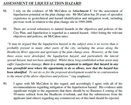
That report based its findings on the return periods set out in Table 1 (columns 2 and
3. Column 4 (shaded blue) is the data used in the early reports.
Table 1 – Comparative return periods
MM Intensity Return Period (years Return Period (years Return Period (As
without without reported in the 1995
microzonation) microzonation) report)
>6 24 10 7
>7 140 50 20
>8 1,800 600 55
>9 74,000 20,000 300
As I understand it, the microzonation distinction relates to the nature of the ground
conditions. “Without microzonation” assumes average ground. “With microzonation”
assumes soft ground as was known to exist, for example, in the Christchurch CBD.
This difference is important because a 55 or even 300 year return period is a level of
probability which planners might reasonably be expect to manage through planning
and building control. If probability was indeed based on a 55 year return period then
failure to address that risk would seem imprudent.
As noted, however, planning decision-making was not based on those early
probability models but on the more recent GNS advice. The secondary issue, on
which there seems to have been varying advice, was which MMI level should be
regarded as representing a potential widespread liquefaction risk.
6.2 Liquefaction risk information limitations
More recent and more specific advice has also been available on liquefaction risk. A
report on liquefaction risk by Beca in 20046 superseded and improved the information
set out in the 1995 GNS report.
5
Estimated damage and casualties from earthquakes affecting Christchurch, GNS 2005
6
Christchurch Liquefaction Study – Stage IV Ecan report No. U04/25, Beca Carter Hollings and Ferner
Ltd May 2004
Earthquake risk in Canterbury: The regional and city councils’ planning preparedness
7ENG.ENF.0001.10
One key question to answer is why, if the councils had specific information on
liquefaction risk, was that information not more directly included in planning
documents?
Although designed to improve knowledge of the spatial extent of possible
liquefaction, the Beca report too had limitations. Christchurch City Council
commissioned a peer review of the report by consultants URS to determine the
extent to which it should be used as a basis for information to be placed on LIMs.
That URS review highlighted the many caveats and qualifications noted in the Beca
report and the limited information on which the liquefaction maps were prepared
(essentially liquefaction zones were modelled using a limited number of data points).
That peer review (with which Environment Canterbury – who had commissioned the
Beca report – agreed) led to an approach to the provision of data on LIMs that
communicated the indicative nature of liquefaction zones. My understanding is that,
due to high variability of soil types, precise and definitive information on liquefaction
risk could only be derived by property-by-property geotechnical investigation.
That may explain why liquefaction zones were not included in the Christchurch City
Plan and why the indicative zones of the Beca Report were applied by the City
Council as a trigger for requiring detailed geotechnical site investigation at the time of
significant new development.
6.3 Risk assessment
The further issue relates to the issue of risk assessment. As noted above, knowing
how likely an event might be is only part of the issue. To effectively exercise their
hazard management planning functions councils need to know the likely
consequences of events. That requires development and application of a risk
assessment methodology. A risk assessment methodology simply means how the
council would go about collecting, assembling and integrating information to quantify
the over risk of an event, or range of possible events (scenarios).
In 2005 Canterbury Regional Council commissioned Opus Consultants to develop
such a methodology7.
The Opus report did provide a high level proposal for a risk assessment model but it
was by no means fully developed. Much work was identified as needing to be done
before there was a usable tool. That work was the subject of recommendations.
At around the same time that report was concluded, the government funded a
parallel piece of work (the “Riskscape” project) undertaken by GNS and NIWA. That
project proposed a national risk assessment model that covered many of the matters
addressed by the proposed Opus methodology. As it turned out, Christchurch had
been selected as one of the pilots for that project and that negated the need to
proceed with the Opus approach. It was not that Environment Canterbury had closed
its mind to the need for risk assessment but simply that a different vehicle had come
along which enabled council to get access to a risk assessment model at lower cost.
This tool is, I understand still in development but an early version is available on the
7
Earthquake Risk Assessment Study Part 1 – review of risk Assessment Methodologies and
Development of a Draft Assessment Methodology for Christchurch, Opus International Consultants
Limited 2005
Earthquake risk in Canterbury: The regional and city councils’ planning preparedness
8ENG.ENF.0001.11
internet. It is a reasonably sophisticated GIS-based model that allows the user to
change input variables and different likely impact outcomes can be calculated.
The other issue of some relevance is how much value an earthquake risk
methodology/model would have had for land use planning decision-making had it
been available earlier. It is my view that, had a risk assessment model had it been
available, it may have been useful but by no means would it have guaranteed better
land use planning outcomes. The fact that a model can quantify (or “index”) a risk is
helpful to an extent, but there is no accepted risk standard for planning such that if
the risk is of a certain scale (either on an index or a quantified value in dollars of
human lives) certain planning approaches/provisions are to be introduced. Such a
standard, though conceivable and potentially valuable, simply does not exist. Thus a
value judgement (cost now versus possible cost avoided) would have been required.
This contrasts to risk standards that apply in, for example, building or flood
management contexts where simple return periods are used.
Finally it should be noted that the 2005 GNS report (commissioned by the City
Council), mentioned earlier, was a form of risk assessment and it provided broad
scale physical damage and human casualty estimates based on three earthquake
scenarios. That indicated a $1.2 billion damage bill and 16 casualties from a 1000-
year return period event.
From the perspective of councils’ obligations to prepare land use plans and consider
resource consent applications, Canterbury’s experience with risk assessment
appears at least as well advanced as other major centres in New Zealand and well
ahead of the smaller regions.
That said, the more critical question is not what risk assessment was done but how
information that was available was used by councils at various stages in the
development process.
7 Overview and Analysis
In practical terms, there are five means by which local authorities can exercise their
earthquake risk management responsibility through land use/development control.
These are as follows:
Ensure hazard risk is factored into urban growth and zoning decisions such that
risk areas are not zoned for vulnerable (or high capital value) activities and/or
mitigation obligations (such as engineering solutions) being required.
Ensure hazard risk is considered at the time subdivision consent applications are
determined such that development of high-risk areas is either not approved
(notwithstanding zoning) or subject to conditions on consent requiring risk
mitigation (i.e. land stabilisation prior to subdivision).
Require geotechnical information as part of building consents and impose
construction standards commensurate with risk (foundation engineering, floor
levels etc).
Earthquake risk in Canterbury: The regional and city councils’ planning preparedness
9ENG.ENF.0001.12
Include relevant information on land information memoranda (LIMs) so the
owners and prospective purchases of land are aware of hazard risk and can
factor that into investment decisions.
Provide information generally to the community so that people can make
business and home ownership investment decisions with some knowledge of risk
being taken.
The first four of these is discussed further below. (The last of these has been well
delivered by Environment Canterbury as noted in section 4.3).
7.1 Managing urban growth and zoning
7.1.1 Urban Growth decisions of Environment Canterbury
Environment Canterbury takes the view that liquefaction and lateral spreading are
not “avoid” issues – meaning the presence of liquefaction risk ought not to constitute
a prohibition on development. As Environment Canterbury’s 31 August letter notes
“it [liquefaction] was a natural hazard risk to be mitigated through those appropriate
engineering measures controlled by the territorial local authorities at the time of
subdivision and building”.
This is the approach that seems to have been taken in Change 1 to the RPS. That
change expanded the urban limits of Christchurch to make available additional land
for greenfield urban development. That planning process took into account natural
hazards insofar as flooding and sea level rise were concerned but it did not involve
assessment of liquefaction risk.
That does seem to be a dubious approach. Although risk associated with
liquefaction may be addressed (in an engineering sense) adequately at time of land
subdivision and building, strategic land use planning provides the opportunity to
ensure that such mitigation (and associated additional cost) is not required at that
time. Identifying areas for development that are known to be at risk of liquefaction
seems unnecessary and only serves to add potential for angst and cost in
subsequent stages of the development process. In other words, a council should not
identify an area of land for actual or potential development that is known to be
susceptible to liquefaction unless there are no other/better alternatives8. That seems
to be the point being made in the good practice (albeit non statutory) guidance that
exists (see Appendix 2) when it includes, as Principle 2, “plan to avoid natural
hazards before development and subdivision” [emphasis added].
That criticism should not be read as suggesting that Change 1 (recently made
operative under the Canterbury Earthquake Recovery Act) has necessarily identified
areas for future development that might be at risk of liquefaction or, that even if it did
so, development in those areas would necessarily be approved. It may well be that
other criteria applied to site selection have coincidentally steered development away
8
There may be instances when, having weighed all the considerations relevant to the suitability of land
for urban growth, an area susceptible to liquefaction still rates highly and is subsequently made
available for urban development (with caveats regarding remedial works required). However, that
decision is reached having transparently identified the risk and considered it against other positive
factors that might outweigh the additional cost/uncertainty of developing liquefaction “at-risk” land. That
does not seem to be the approach advocated by Environment Canterbury in its 31 August letter.
Earthquake risk in Canterbury: The regional and city councils’ planning preparedness
10ENG.ENF.0001.13
from higher risk areas. (A detailed assessment of the new greenfield areas has not
been undertaken as part of this study). Rather, the point being made is that
Environment Canterbury did not, through the exercise of its urban growth
management responsibilities, see it necessary or appropriate to consider liquefaction
risk as a relevant constraint.
7.1.2 Zoning decisions of the City Council
Insofar as zoning decisions of Christchurch City are concerned it is clear from a
recent report commissioned by the Ministry for the Environment (MfE)9 that most
urban zonings (at least within that report’s study area) were confirmed well before
there was information available on earthquake hazards risk in the region.
On that basis, the option of managing risk (to those areas that subsequently suffered
liquefaction) through zoning was never an option realistically available to the City
Council.
In theory, it would also have been possible to “down zone” undeveloped residentially
zoned land known to be at some risk of liquefaction. However that was apparently
not considered (presumably because of traditional planning reluctance to remove
established development rights).
In terms of any zoning that occurred in more recent times and/or not within the MfE
report study area, liquefaction/lateral spread has seldom been considered. One
instance where those risks were investigated and taken into account in decision-
making was in relation to rezoning of land at Ferrymead by way of Plan Change 28.
That matter is discussed in Appendix 6. These issues were also addressed in the
development of Pegasus Bay (in Waimakariri District).
The City Council usefully provided (in its 10 November letter) a summary of relevant
plan changes and an assessment of the extent to which liquefaction/lateral spread
risk was considered (see Appendix 7).
That information shows, that apart from Plan Change 28 already mentioned, very few
proposals assessed liquefaction/lateral spread risk. Appendix 7 shows that in the
majority of cases there was simply no assessment. Plan Change 43 (a private plan
change request) seems to be another exception where geotechnical information was
presented and liquefaction risk was identified. Documentation submitted to council
as part of the private plan change request that became Plan Change 45 also
identified some liquefaction risk but this does not seem to have been carried through
to the section 42A report or decision. Other instances where geotechnical reports
have been received seem limited to post 22 February 2011.
City Council officers do not have expertise in risk assessment and therefore must
rely on information provided by applicants. The key issue here is what triggers
council officers to require applicants to provide the geotechnical/hazard risk
information? That is not clear from the information to hand. It does appear that a
different approach has been adopted post 22 February from that prevailing before
that date.
9
Canterbury Fact Finding Project, Hill Young Cooper and Resource Management Group Ltd, August
2011
Earthquake risk in Canterbury: The regional and city councils’ planning preparedness
11ENG.ENF.0001.14
7.1.3 Managing risk at time of subdivision
The MfE-commissioned “Canterbury Fact Finding Project” reported, in respect of the
eastern suburbs of Christchurch along the Avon River that have been impacted more
severely by liquefaction and lateral spread:
“no evidence [was] found of the consideration of liquefaction or lateral
spreading, either in the documents sourced or the interviews undertaken
Further the same report noted that in respect of section 106 of the RMA 1991, and its
predecessor section 274 of the LGA 1974,
No documentary evidence of the use of these sections of the Acts being used
for the purpose of declining subdivision consent was discovered and neither
was it raised in any of the interviews conducted
This followed from the finding that although zoned before 1977 many parts of the
study area were not developed until after 1977 and quite often not until after 1986
and in some case in the 2000s. It is generally held that information on this risk
(though incomplete for reasons given earlier) was available to councils from the early
1990s.
This is consistent with the feedback received in meetings conducted as part of this
project. It is also consistent with the direction of the Christchurch City Plan, which
though not explicit, seemed to emphasise the use of the Building Act as the primary
means of managing earthquake risk. The Christchurch City Plan does contain some
ability to exercise control at the time of land subdivision but it is not strong in that
regard and would require a case-by-case assessment of risk.
The planning reality is that once land is zoned for a specific use it is very difficult for a
council to refuse a subdivision that enables that use to establish. There is a
presumption that land zoned will be suitable. That was also the view expressed in
the Canterbury Fact Finding Project Report and by City Council officers in the
meeting conducted as part of this project.
As noted earlier, Section 106 of the RMA refers to refusing subdivision if the land in
question is “likely” to be subject to material damage. It seems that Christchurch City
did not regard the probability of an earthquake and subsequent liquefaction and
lateral spread as “likely”.
The key issue here is “was that a reasonable assessment?” - especially taking into
account the liquefaction and lateral spread were not considered at the time the land
was zoned. While it is not within the scope of this project to answer that question
directly, it is relevant to note that case law on this matter does seem to have set the
bar high in determining what is “likely”. Advice received by the City Council on this
matter suggested the risk needs to be “real or substantial”.
Case law and practice on this issue seems based around flood risk, for which a 100-
year return period has established as something of a benchmark. Should that
approach be taken to earthquake risk then it is little wonder the section is never
invoked. Earthquake risk is of course of quite a different nature (and comprises both
rupture and shaking risk) and the consequences, not just the probability, need to be
Earthquake risk in Canterbury: The regional and city councils’ planning preparedness
12ENG.ENF.0001.15
integral to the assessment. Whether this is captured in the term “likely” is a moot
point.
Further, Christchurch City received much advice over the years which (although not
always entirely consistent) would have created a picture of relatively low liquefaction
risk. A letter from GNS to Christchurch City’s Building Control Manager of 14 July
2003 is particularly instructive.
That letter commented on an earlier report entitled Effects of Liquefaction-Induced
Differential Settlements on Residential Dwellings in Christchurch10. Appendix 5
quotes extensively from that letter. In short, the advice received was that:
in the case of a MM7 level earthquake GNS “would note expect to see major
damage to buildings as a result of liquefaction…”
the probability of an MM9 or MM10 earthquake “is sufficiently low that, in our
opinion, it would not be reasonable to require ordinary structure, like house, be
constructed to withstand all the adverse effects of such strong shaking.”
“the majority of houses in Christchurch will not be affected by liquefaction, even
during the strongest shaking (MM8) likely to be experienced”11
These two factors (i.e. the planning presumption/case law hurdle and GNS advice)
together may explain Christchurch City’s approach in continuing to consent
subdivision applications but it does not entirely explain why site
remediation/stabilisation was seldom required as a condition of consent.
It should be noted that the City Council has advised that every subdivision consent
granted contains a note advising that subsequent subdivision or building may be
subject to a requirement for site-specific investigation.
7.1.4 Managing risk through the Building Act
I am not in a position to comment in detail about the use or otherwise of the Building
Act as a means of managing risk. It is outside the brief of this project.
I do note that following advice from consultants URS in 2005, Christchurch City has
been issuing LIMs with broad statements as to whether the site is within a
“liquefaction study area” and referring the reader to Environment Canterbury for
further information.
It is my understanding that geotechnical reports on liquefaction risk were not required
for residential buildings but have been required for commercial/industrial buildings
since the mid 1990s. Presumably appropriate foundation engineering solutions were
then required to address the risk to those buildings.
City Council staff have confirmed that on the basis of the GNS advice detailed in
Appendix 5, the risk to domestic buildings was not considered sufficient to warrant a
change in the foundation engineering requirements for those buildings and
geotechnical reports were not required.
10
Carr, KM, Effects of liquefaction-induced differential settlement on residential dwellings in
Christchurch. Department of Civil Engineering, University of Canterbury (October 2001).
11
This advice was originally included as an assumption in an earlier GNS report Earthquake, volcano
and tsunami risks to property for Christchurch City Council (April 2003) and quoted with agreement in
the July 2003 letter.
Earthquake risk in Canterbury: The regional and city councils’ planning preparedness
13ENG.ENF.0001.16
Given this limited use of the Building Act, references in the City Plan tend to
overstate (in my opinion) the degree to which risk will be managed by that Act. In fact
the approach to risk management, insofar as domestic buildings are concerned
seems to be more a question of accepting what was considered to be a very low
level of risk.
8 Conclusions
A review of planning documents shows that both Environment Canterbury and the
Christchurch City Council recognised the seismic risk, understood their functions
and, in broad terms at least, were carrying out those functions. Inevitably some
questions may be raised about whether (with the benefit of hindsight) planning
responses were adequate and appropriate given known seismic risk.
The research conducted as part of this project suggests that an unclear, evolving and
at times conflicting understanding (or perception) of the risk may have led councils to
adopt what might now be regarded as an inadequate planning approach.
While Environment Canterbury should get credit for its technical work on risk
identification/assessment and information dissemination (which was, apparently,
amongst the best in New Zealand) its role in controlling land use was limited.
That role could have been more clearly articulated in the RPS although there is no
evidence that any lack of clarity around respective regional city council
responsibilities in hazard risk management caused confusion or malpractice. Other
issues include the following.
The operative RPS hazards policies are not particularly helpful – but that is
acknowledged and has been rectified in the recently proposed RPS.
There is a question about whether Environment Canterbury had been advocating
for seismic risk management in planning processes. Liquefaction had been
raised by Environment Canterbury in its appeal against the Pegasus Bay
development but it was very much an “add on”, secondary factor. Environment
Canterbury did not raise liquefaction concerns in its submission on the City
Council’s Change 28 – even though that was clearly an issue. Information from
the City Council indicates that Environmental Canterbury had not been active in
formal earthquake risk advocacy (i.e. through submissions on plan changes and
notified consents).
Environment Canterbury has not seen its role as extending to consideration of
earthquake hazard risk in its land use policy decisions. Change 1, which
extended urban limits, did not take account of earthquake risk on the basis that
liquefaction and lateral spread are considered to be issues to be addressed by
territorial authorities at the time of subdivision and development. At the very
least that seems a highly debatable position for Environment Canterbury to adopt
and potentially inconsistent with the (admittedly general) best practice advice. It
has become clear from this project that the City Council at least, was not
managing risk effectively at those stages of the development process. In that
sense Environment Canterbury’s reliance on those processes seems ill-founded.
Where there are choices to be made about which land is to be urbanised good
Earthquake risk in Canterbury: The regional and city councils’ planning preparedness
14ENG.ENF.0001.17
planning practice would suggest the presence of natural hazards would be a
factor in weighed in the selection process. Nevertheless, the approach had no
bearing on the extent of damage suffered as a result of recent earthquakes as
Change 1 did not become operative until after those events.
Christchurch City Council has responsibility for land use control to manage
earthquake hazard risk. Given the historic nature (i.e. pre seismic hazard
knowledge) of most of its urban land zonings, it has seldom been able to use the
zoning process to limit risk. Change 28 (rezoning of land at Ferrymead) was one
such example where appropriate hazard mitigation was considered as part of the
rezoning proposal. That does, however, seem to be an exception. Other recent
urban growth plan change processes do not appear to have considered earthquake
risk. The key issue being that the City Council has not routinely sought earthquake
risk information as part of private plan change requests12.
Even though there has been limited ability to manage risk at the time of land zoning,
the City Council could, in theory at least, have managed the risk at the time of
subdivision consent (either by declining consent or by requiring land consolidation or
other risk mitigation). However, based on recent MfE-commissioned research, it
seems that has not been the approach adopted by the City Council. That is a matter
that has recently led the Minister for the Environment to add hazard management as
a matter to be addressed in the current round of reform of sections 6 and 7 of the
RMA. A technical advisory group has been appointed to consider this, and other
issues, and is scheduled to report back to the Minister by March 2012.
In my opinion, to the extent that there have been issues with seismic hazard
management under the RMA in Christchurch, those issues are largely systemic in
nature rather than issues related to the competency or commitment of the local
authorities concerned. By systemic I mean a lack of clarity about the level of risk that
should be planned for, ingrained public expectations about the right to develop
suitably zoned land and statutory provisions that are not overly supportive of
planning in the absence of perfect information. This may be addressed, in part at
least, by the Minister’s review of the RMA. There are, in addition, improvements in
planning practice that could be introduced. By and large, these seem to have
already been recognised by the councils concerned. However, greater central
government guidance for local authorities on planning for earthquake risk may be
warranted.
12
The practice in this regard has not been researched as part of this project. It is likely, however, that
council officers are guided by the Web-map electronic data system available to all council officers. This
does include known indicative liquefaction zones.
Earthquake risk in Canterbury: The regional and city councils’ planning preparedness
15ENG.ENF.0001.18
Appendix 1 – Hazard planning responsibilities under the RMA
Environment Canterbury
The relevant functions and duties of Environment Canterbury under the RMA stem
from sections 30, 62 and 65.
Relevant regional council functions – Section 30
Section 30 (a) and Section 30 (b) set out general obligations. Section 30 (a) requires
regional councils to prepare “objectives, policies and methods to achieve integrated
management”. Section 30 (b) requires regional councils to prepare objectives and
policies in relation to any actual or potential effects of the use, development and
protection of land which are of regional significance”.
These are broad functions which (theoretically at least) allow a regional council to
engage in natural hazard management where the risk of regional significance or
where management requires an integrated response.
Here “integration” means integrated between the regional council and territorial
authorities and integrated in terms of the various functions of the regional council (i.e.
control of water takes, river beds disturbance, land use, discharge, occupation of
coastal space etc).
While I note these provisions here, I do so largely for completeness. These
provisions could, it seems to the author, be used to provide a mandate for
hazard/earthquake risk management to my knowledge it is not currently practice for
these sections to be relied on for such a purpose (except insofar as RPS policy and
associated advocacy).
In addition to those general functions, section 30 (c)(iv) includes the specific function
for regional councils requiring:
“the control of the use of land for the purpose of the avoidance or mitigation of
natural hazards”.
Regions also have the function under section 30 (1)(g) to control the planting of any
plant on the bed of any water body for the purpose of avoidance of natural hazards.
That function is not, however, relevant to earthquake hazard management.
Regional policy statements and regional plans
Section 62 (1) (i) (i) provides that the regional council’s (mandatory) regional policy
statement must specify:
“the local authority responsible …. for specifying the objectives, policies and
methods for the control of the use of land -… to avoid or mitigate natural
hazards or any group of hazards”.
This is required because, as noted below, the RMA provides the same function (i.e.
the control of land for the purpose of avoiding or mitigating natural hazards) to both
regional councils and territorial authorities. The Section 62 (1) (i) (i) responsibility is
designed to ensure that the shared responsibility is clearly defined and the function
Earthquake risk in Canterbury: The regional and city councils’ planning preparedness
16ENG.ENF.0001.19
does not “fall through the cracks” with each authority believing the other is carrying it
out.
Section 65 (3) (c) requires a regional council to consider the desirability of preparing
a regional plan when there is likely to arise “..any threat from natural hazards …”
That makes clear that the presence of an actual or potential natural hazards is
grounds to prepare a regional plan or to have a regional plan, prepared principally for
other reasons, address natural hazards.
Christchurch City Council’s RMA functions and obligations
Christchurch City Council’s RMA functions are defined by Section 31 of the RMA. As
noted above, the function in respect of natural hazards largely mirrors that allocated
to regional councils. Section 31 (1) (b) states:
The control of any actual or potential effects of the use, development or
protection of land, including for the purpose of –
(i) the avoidance or mitigation of natural hazards …
This mirrors the regional council function except insofar as section 30 refers to the
control of land use whereas section 31 refers to the control of the effects of land use.
In practical terms, however, little if any distinction is drawn between these functions.
Section 106 of the RMA is also relevant. It states that:
(1) A consent authority may refuse to grant a subdivision consent, or may grant a
consent subject to condition, if it considers that –
a. The land in respect of which a consent is sought, or any structure on
the land, is or is likely to be subject to material damage by erosion,
falling debris, subsidence, slippage, or inundation from any source; or
…
It may be relevant to note the Section 106 has (arguably) been diluted since first
included in the RMA in 1991. Until legislative amendment in 1993, section 106 had
read “shall not grant subdivision consent”13. This was consistent with section 274 of
the Local Government Act that addressed land subdivision prior to the enactment of
the RMA in 1991. The section now directs that councils “may” refuse consent.
General duties
In addition to the above specific functions and plan-making responsibilities, all local
authorities have general duties under the RMA that are relevant to the management
of natural hazards.
Duty to gather information
Section 35 (1) requires every local authority to gather information and undertake or
commission research necessary to effectively carry out its functions.
13
It should be noted that the previous wording was not absolute. Provision was made for consent to be
granted provided the local authority was satisfied that the risk could be mitigated by rules, conditions or
works.
Earthquake risk in Canterbury: The regional and city councils’ planning preparedness
17ENG.ENF.0001.20
Section 35 (2) requires every local authority to monitor the environment in its district
or region.
Section 35 (3) requires local authorities to keep information available which is
relevant to the administration of policy statements and plans to enable the public to
be better informed.
More specifically, Section 35 (5) (j) requires local authorities to keep:
“records of natural hazards to the extent that the local authority considers
appropriate for the effective discharge of its functions”.
Duty to consider alternatives, benefits, and costs
While not specific to natural hazards, the general duty to consider alternatives,
benefits and costs is relevant to the extent that the duty can act as a “governor” on
the development and implementation of policies and rules. To avoid unjustified or
irrational intervention.
In essence, the section requires councils to consider the appropriateness of
objectives and the effectiveness and efficiency of policies and rules or other methods
before proposing or adopting them. This is to be done having regard to the benefits
and costs of the policies and methods and the risks of acting or not acting.
It is commonplace to refer to the “section 32 test” which is generally regarded as the
benefits outweighing the costs and/or risks. Section 32 has an important role in
determining what, if anything councils do in response to species issues and risks.
Earthquake risk in Canterbury: The regional and city councils’ planning preparedness
18ENG.ENF.0001.21
Appendix 2 – Hazards Planning Best Practice Guidance
Planning for Development of Land on or Close to Active Faults
In March 2001, the Parliamentary Commissioner for the Environment released the
report Building on the Edge – The Use and Development of Land On or Close to
Fault Lines14. The Commissioner’s investigation arose following public concern that
local authorities were not able to adequately manage the use and development of
land on or close to active faults.
The PCE report focused on the Building Act 1991 and the Resource Management
Act 1991 (RMA). It reached a number of key conclusions.
There is no technology to prevent earthquake damage to buildings built across
faults.
Few territorial authorities identify and plan for seismic hazards, despite their
responsibilities for subdivision and land use.
Practical guidelines are urgently needed to reduce the risks associated with fault
rupture.
Specifically recommendation 1 (below) of the PCE report proposed that priority be
given to:
The Ministry for the Environment working together with the Institute of
Geological and Nuclear Sciences and other interested organisations with
structural and geotechnical expertise to develop best practice guidelines for
territorial authorities in avoiding or mitigating seismic hazard through the
district plan process.
An essential first step will be the identification of barriers to incorporating
scientific information into the policies, objectives and rules in plans and policy
statements under the Resource Management Act 1991; the investigation and
evaluation of planning and other options to reduce risk in different situations
depending on seismic hazard type and the level of certainty that exists; and
establishing a dialogue with local authorities to increase awareness of
seismic problems and potential solutions.
The report referred to in the first part of the recommendation was duly prepared in
the form of the Planning for Development of Land on or Close to Active Faults, 2003
(“the Active Fault Guideline”).
The following text describing the scope of the 2003 guideline is taken (with minor
amendment for clarity) from its summary.
The first part of this guide focuses on the need for a risk-based approach to
planning for land use on and near active faults. It recommends that councils:
identify active faults in their district, with maps that are at the
right scale for the purpose
14
http://www.pce.parliament.nz/publications/all-publications/building-on-the-edge-the-use-and-
development-of-land-on-or-close-to-fault-lines-2
Earthquake risk in Canterbury: The regional and city councils’ planning preparedness
19You can also read