Cycle Friendly Deal A Road Map - Deal Town Council
←
→
Page content transcription
If your browser does not render page correctly, please read the page content below
Cycle
    Friendly
        Deal
     A Road Map

1
Table of Contents
Background........................................................................................................................... 5
The Vision ............................................................................................................................. 5
The Mission .......................................................................................................................... 5
The Objectives ...................................................................................................................... 6
The Targets .......................................................................................................................... 7
The Budget ........................................................................................................................... 7
The Project Geography ......................................................................................................... 9
A Regeneration Project ....................................................................................................... 10
Infrastructure ....................................................................................................................... 12
Cycle Network ..................................................................................................................... 13
   Quietway 1 ...................................................................................................................... 15
      Quietway 1 – Godwyn Road to Golden Street ............................................................... 16
      Quietway 1 – Golden Street to Park Avenue ................................................................. 17
      Quietway 1 – Park Avenue to Hamilton Road ................................................................ 19
      Quietway 1 – Hamilton Road to St Richard’s Road ....................................................... 20
      Quietway 1 – St Richard’s Road to Station Road .......................................................... 21
   Pier to Park via Quietway 1.............................................................................................. 22
      Sholden ....................................................................................................................... 23
   Mill Hill – Quietway 1 to Rectory Road .............................................................................. 24
   Wider Mill Hill – St Richard’s Road & Mongeham ............................................................. 24
   Quietway 1 – National Cycle Route 1 – Walmer Connection.............................................. 25
   Sustainable Transport Chains ......................................................................................... 26
   Church Path – A long-term goal........................................................................................ 27
Leisure Cycling Routes ....................................................................................................... 28
   Pier to Parlour ................................................................................................................. 29
   Pier to Pit ......................................................................................................................... 31
    Time Cycle ..................................................................................................................... 33
   Royal Ride ....................................................................................................................... 34
Signage .............................................................................................................................. 36
   Signage Portfolio ............................................................................................................. 37
Cycle Parking ...................................................................................................................... 38
Walking & Cycling Map ....................................................................................................... 39
Leisure Route Maps ............................................................................................................ 40
Ebike Hire Scheme ............................................................................................................. 41
Visitor Promotion................................................................................................................. 42
   Toolkit ............................................................................................................................. 42
   Grants ............................................................................................................................. 42

                                                                    2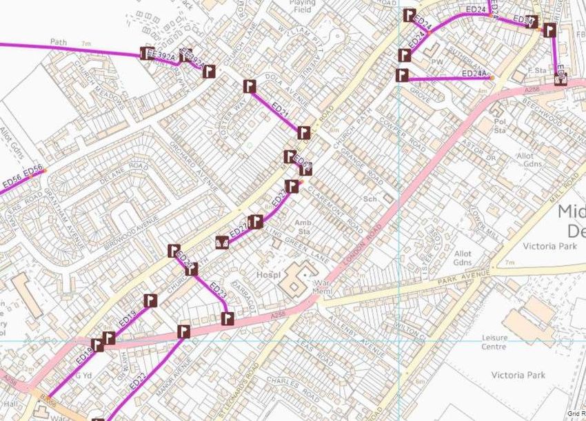
Events ............................................................................................................................. 42
   Good Journey .................................................................................................................. 42
   Tourism Partners ............................................................................................................. 43
Events ................................................................................................................................. 44
   E-Bike Launch ................................................................................................................. 44
   Bike Week ....................................................................................................................... 44
   Carnival Cycle Parade ..................................................................................................... 44
   Cycle To Work Day .......................................................................................................... 44
   Cycle September ............................................................................................................. 44
   East Kent Artists Open House Rides ............................................................................... 44
Business & Bikes Programme ............................................................................................. 45
   Kent Connected............................................................................................................... 45
      Workplace Travel Challenge ........................................................................................ 45
      Cycle Loans ................................................................................................................. 45
      Cycle Training .............................................................................................................. 45
      Cycle / Walk videos on Kent Connected ....................................................................... 46
      Jambuster .................................................................................................................... 46
   Cycle to Work Scheme .................................................................................................... 46
   Cycle to Shop Day ........................................................................................................... 46
Cycle Safety Campaign ....................................................................................................... 47
Communications ................................................................................................................. 48
Appendix 1 – National Cycle Route 1 Signage Audit ............................................................ 49
Appendix 2 – Cycle Parking Review ..................................................................................... 51

  All maps contained within this document © Crown Copyright and database rights
  2017, OS licence number 100019238

                                                                    3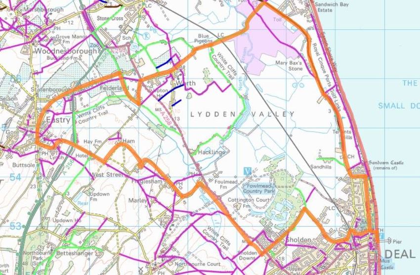
The Cycle Friendly Deal Road Map is a working document that will evolve as the
Project develops.
Cycle Friendly Deal has been developed collaboratively with local people and
supporting agencies. This collaborative process will continue throughout the life of
the Project to ensure that the actions taken truly support the local community.
All thoughts and comments on this document and Cycle Friendly Deal are greatly
appreciated. Please send any contributions to:
Adrian Oliver
Adrian.oliver@deal.gov.uk

                                         4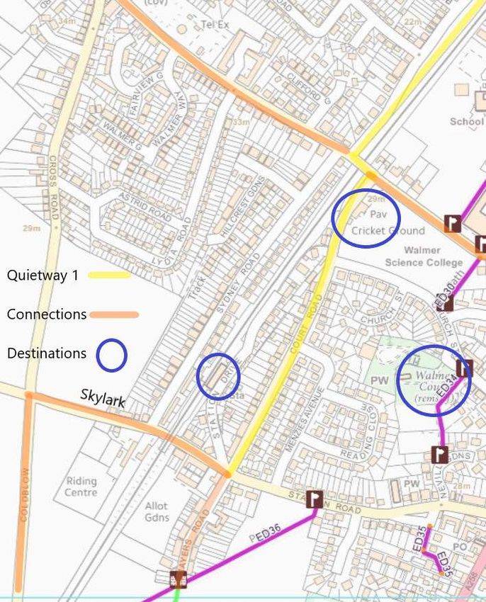
Cycle Friendly Deal
                                                 A Road Map
                                                October 2018 – March 2021

Background
Cycle Friendly Deal is a two-year project to promote more cycling in Deal and more
cycle tourism to Deal. Deal Town Council’s Regeneration Advisory Committee
successfully bid for funds from the Government’s Coastal Communities Fund. The
Town Council supplemented the government’s funds to create a total budget of
£116,000.

The Vision
To make the Deal Urban Area the best place to cycle

The Mission
Deal Town Council will encourage cycling through improvements in infrastructure;
visibility; promotion; information; education; and continued political support in order to
make the Deal Urban Area an even more attractive place to live, work & especially
visit, so improving the visitor economy and increasing employment.
This will be achieved through collaboration with:
   •   DTC councillors & officers
   •   cyclists
   •   residents
   •   schools
   •   local groups
   •   businesses
   •   local & national organisations
   •   other local town & parish councils
   •   Dover District Council
   •   Kent County Council.
Deal Town Council will ensure that the work started will continue to develop beyond
the life of the project, so continuing to encourage and support cycling for the benefit of
the whole area.

                                            5
The Objectives
Deadline         Objective                           Status as at 010419

November 2018    Launch                              Complete

March 2019       Work on Cycle Trails                In Progress

March 2019       Design Publications                 In progress

March 2019       Set Up online marketing             In progress

March 2019       Agree Signage with Highways         In progress

March 2019       Ebike Research & Plan               Complete

March 2019       Investigate Suppliers               In Progress

March 2019       Set up e-bike hire Systems          In Progress

March 2019       Design eBike Marketing Materials    In Progress

April 2019       Cycle Trail Launch at CAM           In Progress

April 2019       Purchase eBike                      In Progress

June 2019        Launch eBike Share Scheme           In Progress

June 2019        Engage local businesses             In progress

June 2019        Install Signage on Cycle Routes     In Progress

June 2019        Print Maps & Distribute             In progress

September 2019   Cycle Friendly Deal Event           In progress

February 2020    Cycle Safety Campaign               In Progress

June 2020        Marketing of Cycle Trails           In progress

September 2020   Cycle Friendly Deal Event 2         Outstanding

September 2020   Continuation of Cycle Hire Scheme   Outstanding

                                         6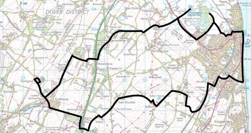
The Targets
Item                                           Target    By
Direct Jobs Created                            4 FTE     30 March 2021
Indirect Jobs Created                          1 FTE     30 March 2021
Private Businesses Supported                    12       30 March 2021
New Businesses Started                           1       30 March 2021
Increase in Visitor Numbers                    5,500     30 March 2021
New Visitor Expenditure                       £151,000   30 March 2021
New Tourism Events Supported                     2       30 December 2020
Non-Vocational Trainees                         13       30 December 2020
Individuals Supported                           13       30 December 2020

The Budget
Item                                                                      Amount

Staff Costs                                                               £47,117

Launch / Close Events                                                      £1,000

Business Engagement Events                                                 £1,000

Cycle Path Signage                                                         £5,000

Publications including Map (design to distribution)                        £7,000

Grants                                                                     £2,000

Public Cycle Scheme                                                       £22,960

E-Bike Fleet Purchase                                                     £10,000

Cycle Racks                                                               £10,000

Safety Campaign Materials                                                  £3,000

Event Costs                                                                £2,500

Evaluation                                                                 £3,000

Insurance                                                                  £1,500

Total Budget                                                             £116,077

                                          7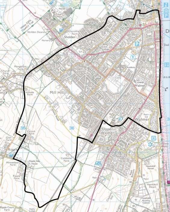
Project Budget Outline
      October 2018 - March 2021

                                  Staff Costs
             2%
      12%
                                  Ebike Fleet Purchase &
 2%                               Management
4%                                Cycle Rack Installations
                  41%

9%                                Cycle Path Signage

                                  Business Support

                                  Promotional Activity
       30%

                                  Evaluation

                  8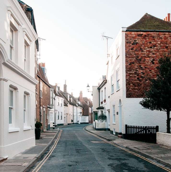
The Project Geography
When referring to Cycle Friendly Deal, we are
referring to the Deal Urban Area plus
Mongeham. That covers the council areas of
Deal, Walmer, Sholden & Mongeham. It is
within the Dover District Council area and its
urban neighbours are Sandwich and Dover.
The map on the right outlines the project area
of the four councils.
There is a population of 31,140 in 14,540
households owning 15,872 cars & vans.
Deal & Walmer are built on a shingle bank, a
great fosse, a spit that grew northwards from
the cliffs at Kingsdown to the River Stour at
Sandwich. Upper Deal, Mill Hill, Sholden and
Mongeham are situated on chalk, the base of
the North Downs.
So, the project area is flat, eventually rising gently inland to peak at Great Mongeham,
reaching a dizzying height of 100 feet.
The project area is compact. The table below illustrates how small. The longest cycling
journey across the area is from Walmer Castle to Betteshanger Park and is just 4 miles
– 30 minutes on a bike at a leisurely 9mph*.

 From                   To                            Distance          Cycling Time*

 Sandown Castle         Walmer Castle                2.8 miles            21 minutes

 Deal Pier              Sholden (New Road)            2 miles             15 minutes
 Great Mongeham         Sandown Castle               3.2 miles            24 minutes
 Walmer Castle          Betteshanger Park            4.1 miles            30 minutes

So, a compact and flat area. The question one has to ask is: why on earth is everyone
incurring the expense and inconvenience of driving?
The answer lies in the barriers that have developed in the area’s infrastructure.
The railway cuts through the middle of the area presenting a physical barrier with 9
crossing points (two gated, one automated level, two bridges over, four bridges under).
This barrier is augmented by the A258 that comes in from the south through Walmer,
along the Seafront to Deal town and then out through the North West through Sholden.
A second busy traffic road the B2056 cuts across the area from the coast inland.
To exacerbate the situation, many potential traffic free routes do not permit cycling.
So, the answer to the question “why is everyone driving?” is:
        People do not cycle because it is actively discouraged by design.

                                            9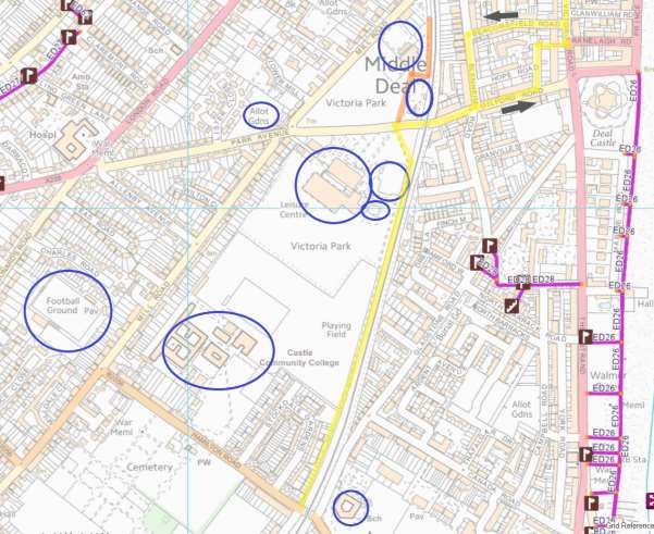
A Regeneration Project
The Deal & Walmer areas are seen as comparatively prosperous. These are not down
at heel seaside towns. However, like many places the area has pockets of stubborn
deprivation that are masked by affluent neighbours.
Historically the area has received its fair share of economic blows including the demise
of the coal mining industry in the latter half of the twentieth century followed by the
retreat of the Royal Marines (1996) and then the abandonment of the pharmaceutical
giant Pfizer at the turn of the 21st century.
No major inward investment has occurred to counter these losses. These
disinvestments have altered the area’s economic demographics. Of the population,
57% are 16-64 and 26% are 65 or over (KCC area 20% are 65+),i Much of the
population - 60% - commutes to work outside the area and 10% works from home.ii
Deal’s status as a commuter town has been enhanced through Southeastern
Railway’s investment in the High-Speed Javelin service that now serves both Deal &
Walmer stations. The Javelin began service after the last Census, so its impact is not
reflected in the commuting data we have. This indicated that just 5% used the train
whilst 70% commuted by car, van or motorbike. Cycling commuters represented just
3% of the working population in 2011.iii
Within the area, sectors that continue to thrive include Hospitality, Retail, Health and
Education.
Indeed, Hospitality could expand further as the night time economy is quite limited and
there is a distinct shortfall of visitor accommodation. The re-opening of The Regent as
a cinema would be a significant asset for residents and visitors enhancing the night-
time offering.
Hospitality is the economic focus of Cycle Friendly Deal. According to the 2011 6% of
the working population was employed in the sector (5% KCC).iv The 2017 Economic
Impact of Tourism Reportv produced a similar figure of 808 Full Time Equivalent
directly employed in hospitality with a further 373 indirect & induced employment.
The Economic Impact of Tourism Report also tells us that in 2017:
    •   There was a total of 1,505,000 day trips to Deal with a spend of £39,677,000
    •   Visitors spent 325,000 nights in accommodation spending £16,057,000
    •   53% of staying visitors stayed with friends, relatives or in second homes
    •   Visitors who stayed with friends & relatives, stayed longer and spent more
    •   Business visits represented just 3% but 29% of the total spend
    •   Day visitors spent 5 times as much as staying visitors in shops, 4 times as
        much on food & drink and twice as much on Attractions.
These are big numbers. It is hoped that by providing visible and tangible support to
businesses within the sector, visitors will increase, and employment will grow. Cycling
visitors stop more often, spend more often and have a wider local impact.
In Retail, Deal High Street is bucking the trend and relatively thriving due to its lack of
national chains making a unique mix of local modern and traditional shops. The
impending departure of two national chain retail outlets, Marks & Spencer’s and

                                            10
Mountain Warehouse, is disappointing, but Deal’s reputation means these units are
unlikely to be vacant for long. M&S’s corporate problems meant that it could not sustain
its large retail presence when it could not offer shoppers what they wanted.
The area has seven primary schools and one secondary academy, representing a
considerable investment in resources and employment. In fact, 10% of the working
population of the Deal Urban Area are employed in the Educations Sectorvi. Schools’
sphere of influence is significant so they can act as a catalyst for change if there is
support throughout the school structure.
This is a regeneration project as cycling is seen as a way to further increase the
prosperity of the town and make it an even nicer place to be and to visit. Cycling has
many benefits and helps us to achieve accessibility, liveability, sustainability and
health goals. Research is clear - cycling has a positive social & economic impact:
• A kilometre covered by bike yields a social benefit of 0.68 euro, whereas cars
and busses costs society 0.37 and 0.29 euros per km travelled respectivelyvii
• Cyclists shop more locally, more often and are more loyal compared to car
driversviii
• The annual cost of riding a bike is approx. £250 whereas the annual cost of
driving a car is approximately £7,300ix
• Cycling is more affordable than driving a car and allows people to get access to
a larger range of options for jobs and activitiesx
• Cycling allows the elderly to remain socially active for longerxi
• Cycling requires social interaction with other road users to mediate traffic flows
or to prevent collisions. As a result, cycling is experienced as a social activityxii
11Infrastructure
To make Deal the best place to cycle means we need to get people cycling. Without
local people cycling, visitors aren’t going to cycle. Tourists will not perceive Deal as a
nice place to visit and explore by bike.
The main barrier to cycling is safety. Safety is not defined by the blunt instrument of
Killed or Seriously Injured (KSI) data. It is defined by how safe vulnerable road users
feel: how threatened by speeding vehicles; or large vehicles; or drivers not giving
space; or drivers distracted by phones, food & entertainment systems. However, the
barrier to changing this situation is our own Government and County Authority. As
Chris Boardman stated, “At a national level with government, there is just no appetite
for any meaningful change.”xiii
Due to austerity, the Department for Transport will not pass funds to Kent County
Council to invest in pro-active Highways schemes. In addition, due to a lack of political
will within Kent County Council, the Authority will not develop Cycling Infrastructure
Plans to bid for funds when they do become available. Which they do from time to time.
To exacerbate the situation, the Highways network continues to grow but the
maintenance funds provided by the DfT does not increase.
The only work Kent Highways are able to do is extreme Road Danger Reduction where
there has been a cluster of three or more Killed or Seriously Injured (KSI) incidents.
Consequently, there will be no investment in major road improvements or cycle
infrastructure in the area.
Kent Highways do have a duty to fix issues on public rights of way and the highway,
xivxv
so it is important that we all report issues, such as pot holes, vegetation problems,
broken drains, when discovered through the appropriate websites and apps.
Kent Highways Fault Report Page Kent Public Rights of Way Report Page
Until Kent County Council takes cycling seriously and treats it as a proper mode of
transport, we will develop work arounds to do our best to support and encourage
cycling. To create the best for cycling means we have to have a three-pronged
approach:
• Infrastructure (!)
• Promotion
• Build Influencer Support
12Cycle Network
As a short term - two year – project, the opportunity to develop a dedicated network of
cycle paths is not realistic. It requires serious amounts of money and serious political
commitment at all levels. Neither of which are available.
It is possible to knit together a network of quieter roads and paths to create safer, more
comfortable cycle routes. Guiding cyclists away from busy traffic areas into pleasant,
useful, efficient routes. The network must connect cyclists with places they want to go.
National Cycle Route 1 (NCR1) is a good route to get cyclists to and from Deal. As it
travels through the project area, it is mainly a traffic free section. However, there is no
signage guiding travellers off NCR1 to explore the area. So as a utilitarian, functional
route, National Cycle Route 1 scores poorly. It ploughs north-south along the exposed
seafront, divorced from Deal Town by the A258, away from many useful destinations
and amongst people promenading and walking their dogs.
Working with Sustrans (the national charity making it easier for people to walk & cycle),
the custodian of the National Cycle Network, we will improve the directional signage
along NCR1 from Sandwich to St Margaret’s-at-Cliffe. Sustrans Rangers from
Medway1 have audited the route and produced a list of actions required to make the
route of NCR1 clear (see Appendix 1). Rangers from Canterbury will install National
Cycle Network Stickers and more permanent signage will be installed by KCC. This
will enhance the experience of users of NCR1 and enable more visitors to get to Deal
quickly, efficiently and confidently from the north or the south. Using NCR1, and in
particular The Pier, we will grow a network inland and through the area. This will start
with adding directional signage from NCR1 to destinations and routes in the Deal
Urban Area.
Discussions have been held with Kent Highways regarding the conflict between riders
and walkers on the shared path section of NCR1. The Folkstone seafront solution of
‘share with care’ signs will be implemented.
Concerns over the condition of NCR1 have been expressed. The section from Walmer
Castle to Kingsdown has been resurfaced thanks to DDC. The section between
Walmer Castle and Deal Castle is scheduled to be resurfaced during the financial year
2019/20.
For local people, a new North-South connected cycle route is required – Quietway 1
(Q1). With a visible, coherent cycle network it will encourage residents of all ages and
abilities to leave their cars at home and ride – to work, school, activities, events and
shop. It will also encourage visitors to spend time here exploring and enjoying our
hospitality.
From these two spines, NCR1 and Q1 we will grow ribs connecting them with places
inland and towards the coast. The path of all the routes has come from historical
cycling activity and consultations with people across the area.
All the routes here are in a draft format. They are likely to change as more people
test them and risk assessments are completed.
1 The Rangers also noted that the arrangements in the vicinity of the Royal Hotel were confusing.
1314
Quietway 1
Quietways are a Dutch concept that Transport for London has successfully deployed
over recent years. Across London, Seven Quietways are almost complete and another
5 are planned. The Mayor of London wants to drop the branding ‘Quietway’, along
with ‘Cycle Super Highway’, in order to promote a more cohesive cycle network brand.
This makes sense when your managing hundreds of kilometres of cycle network.
When implemented, the Deal Urban Area will have a cycle network of a handful of
kilometres, so integrated branding isn’t really a problem!
The Deal Urban Area Quietway will not have the same level of Highways Management
but will follow the guiding principle of helping riders to get to destinations on lower
traffic streets.
In developing Quietway 1, we’ve attempted to follow the principals of safety, continuity
& intuition. This proves tricky at the southern end of Deal High Street with the one-way
system. As Q1 gets established, it is hoped more traffic management could be put in
place to make the route more comfortable. Moving to a situation where we are
promoting Active Safety (prevention of accidents) rather than Passive Safety
(softening the outcome of accidents), so a better network rather than recommending
helmets and hi-vis clothes. This could start with simply reducing the speed limit on the
roads Quietway 1 uses to 20mph.
Quietway 1 (Q1) guides cyclists North/South through the Deal Urban Area from
Sandown in the north through Walmer in the south. It follows:
   •   Sandown Road
   •   Middle Street
   •   Oak Street
   •   St Patrick’s Road
   •   St David’s Road
   •   Albert Road
          o Southerly
                  ▪    Beechwood Avenue
                  ▪    Mill Road
          o Northerly
                  ▪    Mill Road
                  ▪    London Road
   •   Victoria Park (traffic free)
   •   Telegraph Road Cycle Path
   •   Court Road

                                          15
Quietway 1 – Godwyn Road to Golden Street
This northly section of Quietway 1 connects directly with National Cycle Route 1 and
uses the quietest north-south road in the area, Sandown Road, compared to the much
busier Golf Road, College Road and The Marina. The Marina is a rat run as it connects
via Beach Street, with the A258. Being the seafront road, The Marina is also a high
traffic street during the season, aggravated further by the free parking bays. Sandown
Road also provides cyclists with protection from the sea winds during the low season.
The route provides a good facility for this high-density residential area allowing access
to the rest of the Deal Urban Area. The Quietway is not far from the Allotments, the
seafront, Golf Road Community Centre and Surgery, Sandown Primary School, North
Deal Playing Fields and a variety of clubs, pubs and other venues.
16Quietway 1 – Golden Street to Park Avenue
Sandown Road meets Middle Street and ventures into the heart of Deal’s conservation
area. The streets narrow and traffic dissipates further. Middle Street also provides
relief from seafront traffic and visitors as well as protection from the low season sea
winds and runs parallel with the High Street.
At Oak Street Q1 heads inland in order to avoid the one-way system and the traffic.
Following the existing marked cycle route, Q1 heads up St George’s Road, providing
direct access to the north end of the High Street, Visitor Information Centre,
Wednesday Market, St George’s Church and the Deal Maritime & Local History
Museum. Nearby are The Landmark Centre; Saturday Market; Astor Community
Theatre; Shops, bars, pubs, cafes and chip shops.
The route joins St Patrick’s road with a connection to Deal Station and Sainsbury, then
St David’s Road. Q1 then joins Albert Road, still following the existing marked cycle
route.
Action: Highways Improvement: 20mph speed limit - Albert Road
Middle Deal Road connects with Albert Road and provides routes to Betteshanger
Park and Sholden.
The Albert Road ‘roundabout’ does have effective cycle management, so the southerly
route is much better as riders are guided across the roundabout and the London Road
into Beaconsfield Road (one way). Then left into Mill Lane and right into Victoria Park
picking up the traffic free path to Gilford Road. The northerly route from Victoria Park
follows Mill Road to London Road at which point there is no alternative but for riders
to follow the A258 for 200m and then take a filtered right turn into Albert Road. The
one saving grace is that it is downhill.
Action: Highways Improvement: Cyclists Warning Signs on the A258 on the Railway
bridge and opposite the petrol station. 20mph limit from Albert Road to Traffic Lights
NCR1 Connection: From the Quietway 1 Oak Street junction there is a short link to
NCR1 and a connection into the town centre. NCR1 connects with the seafront and
the Pier, South Street Bus Station, The Regent Cinema (tbc), Timeball Museum, Deal
Castle and onward to Walmer.
Town Centre North Connection: From the Quietway 1 Oak Street junction this runs
parallel with the pedestrianised High Street providing access to toilets, cycle parking,
shops, cafes, bars and the library.
Town Centre South Connection: At Gilford Road there is already a sign towards the
Town Centre, but there isn’t any further guidance. From the traffic free cycle path, the
route joins Gilford Road heading towards the coast and passing under the railway. This
is not a comfortable section as Gilford Street is a main thoroughfare and the crossing
under the railway is narrow. It continues on Gilford Road and then bears left into Hope
Street. Through a neat piece of permeability, Hope Street meets up with Victoria Road
merging into the one-way system and turning right into Sondes Road. Sadly, this meets
up with a short section of the A258. However, it is on the seafront, by the Timeball
Museum and near the Pier and traffic moves slowly but constantly. The moving of the
17“Bus Waiting” bay from Breach Street into South Street would be helpful. Left into
South Street brings the route to the “Bus Station” and right into Middle Street takes the
route to the Library and more cycle parking.
Heading back toward Gilford Street from South Street is not smooth, nor comfortable.
This runs through the one-way system and against the flow of traffic which means it
cannot run continuous. There is a walking section on Victoria Road between Sondes
Road and Stanley Road. After this, riders can remount following Victoria Road and
then a right turn into Beaconsfield Road. This one-way street heads inland to meet
with Blenheim Road running one-way south. At the next junction the route turns right
onto Gilford Road and under the railway, heading towards the traffic free cycle path.
18Quietway 1 – Park Avenue to Hamilton Road
This traffic free section runs alongside Victoria Park and Goodwin Academy fields. It
gives direct access to the park, skate park, Linwood Youth Centre and Tides Leisure
Centre (swimming pool, gym & indoor tennis). The route is close to:
o Gymnastics Club
o Bowls Club
o Allotments
o Goodwin Academy
o Adult Education Centre
o Deal Town FC
o Cemetery
o Deal Parochial Primary School
South of Victoria Park, the path is fenced (Academy/housing on the west, railway on
the east). It is a narrow, shared path and the overgrowing vegetation can make the
route even more restricted. But it is traffic free.
19Quietway 1 – Hamilton Road to St Richard’s Road
The shared path ends sloping towards Hamilton Road, the B2056. The route continues
across this road into Telegraph Road. The B2056 kinks left before passing under the
narrow railway bridge making visibility heading north tricky. Some management of this
crossing would be beneficial. This could include extending the 20mph speed limit zone
further along Hamilton Road to the length of Hamilton Road and the length of Cornwall
Road as well as “Cyclists Crossing” Warning Signs. Once into Telegraph Road riders
can join the Shared Path or stay on the road. The only issues with the shared path are
the interruption to get across Somerset Road which could be resolved by raising the
path across the road and giving it priority; and the inability to join the path seamlessly
at the St Richard’s Road junction.
The route along Telegraph Road runs near allotments and Downs School. Despite
Downs Road being one of the few 20mph streets in the area, safe access to the school
at school-run time is not currently achievable due to the parked cars, speed bumps
and volume of traffic. The only protected access is along the narrow ED29 footpath.
Upgrading and widening ED29 to a dual walking & cycling path would be incredibly
beneficial to the area if there is any future development of the former secondary school
site.
The other 20mph limit street in this section, Freemen’s Way, is far quieter and provides
good access into Mill Hill.
20Quietway 1 – St Richard’s Road to Station Road
The junction of Telegraph Road/St Richard’s Road/ Court Road/Salisbury Road has
been improved in recent years due to an infant fatality. So Q1 bear lefts at the end of
Telegraph Road over the Bridge over the railway and follows the road as it bears right
into Court Road. The junction here connects with a route inland towards Mongeham
and coastbound to NCR1.
Q1 directly connects with the Cricket Club, Walmer Station and the Skylark Trail to
Dover. This inland quiet route to Dover may be realigned along Mayers Road and the
newly surfaced bridleway (ED58) through the Station Road Development. This
bridleway connects to another, EE442, which continues to Ripple Road. Surfacing
EE442 would create a 1km traffic free section of the Skylark Trail and avoid the gated
railway crossing making an uninterrupted route. It would also shorten the route by half
a kilometre.
21Pier to Park via Quietway 1
Betteshanger Sustainable Park, managed by the Hadlowe Group, aims to double
visitor numbers to the Park to 250,000 per year. The investment programme includes
new adventure play area, improved landscaping and access, a new building housing
a café, cycle shop and repair centre, changing facilities, flexible conference rooms,
sustainable energy display and a Mining Museum. Betteshanger is one of only two
British Cycling Tracks in Kent. It also has a growing Mountain Bike course.
Consequently, with such a significant visitor attraction in the area, it’s important we
ensure it is effectively connected.
The Pier to Park cycle route takes riders from The Pier on NCR1 and connects with
Quietway 1 at Oak Street. From Albert Road it follows Middle Deal Road then
Southwall Road which peters out to a surfaced bridleway. This is usable by all but the
most delicate road bikes. The route ends at Colliers’ Gate at the rear of Betteshanger
Park. This gate has been designed to mitigate some of the Antisocial Behaviour in the
vicinity and provide security for the Park. It is a tricky entrance with a bike. It is hoped
that the Management Team at the Park will be able to improve access for cyclists whilst
not undermining the need for security.
A new link road through the Albert Road Development and South Wall Industrial Estate
presents some concerns at the Church Lane junction. This will be assessed by Kent
Highways as part of the Highways Completion Safety Audit. A simple solution would
be to paint in a right turn filter lane to provide additional protection for cyclists.
Sholden Link – Branching off South Wall is another surfaced bridleway (EE385) – Marsh
Lane. This connects with New Road in Sholden providing direct access to Edward
Vinson (Turnhouse), Hull Park Sports Club and the historic Miners’ Cycle Track. A
shared path runs along New Road as part of the recent development, which includes
a Toucan crossing over the A258. A newly tarmacked and upgraded shared path
connects New Road with The Street.
22Quietway 1 to Vicarage Lane, Sholden
From Quietway 1 at Albert Road, this route follows Middle Deal Road, into South Wall
Road and then follows the road round into Church Lane. At the end of the road the
route continues, on to the newly tarmacked and upgraded shared path – still Church
Lane – reaching St Nicholas Church at Sholden on the A258, opposite permeability
that takes riders into the cul-de-sac and the rest of Sholden village.
Rhubarb Path – As part of the development on Mount Bros Ltd land, this footpath
(EE392A), connecting The Street, Sholden more directly with the Persimmon
Development and the north end of Church Lane, has been surfaced and widened to
1.8m. Riders are already using it as it is a comfortable & useful route. We will pursue
permission to formerly upgrade it to allow cycling.
Sholden
Sholden village sits just beyond the outskirts of Deal on the A258. For some years,
Sholden Parish Council has been pursuing a policy of upgrading paths to enable
pedestrians and cyclists
to navigate the village
away from the busy
trunk road. This has
resulted in a network of
useful paths through
the village and
connecting with Deal.
This work has also
restored the usability of
the Miners’ Cycle
Track, which was
isolated by the
intimidating A258.
23Mill Hill – Quietway 1 to Rectory Road
This route travels through the densely populated residential area of Mill Hill, connecting
it with the rest of Deal & Walmer. It also keeps cyclists away from the busy B2056
Manor Road, creating a far more comfortable way to get about in Mill Hill.
From Telegraph Road, the route follows one of the few 20mph streets in the area,
Freemen’s Way. This goes up to the busy Mill Hill where shops, including a bike shop,
and other amenities are based. The route continues straight across Mill Hill into St
James’ Close and with some cunning permeability meets up with Trinity Place. Two
cul-de-sacs and a 20mph street makes this a decent Quietway. At the end of Trinity
Place, it meets Pilots Avenue and left into Addelam Road reaching Rectory Road.
However, Addelam Road is a coast bound one-way street. The solution is to allow
riders to contra-flow up
from the Pilots Avenue
junction and to manage
the traffic heading from
the Rectory Road
junction by making the
street “Access Only”.
From Rectory Road
riders can access
Church Path or head
towards St. Richard’s
Road.
Wider Mill Hill – St Richard’s Road & Mongeham
As well as the above route, St Richard’s Road also connects with Quietway 1, linking
a number of amenities including school, surgery and church. St Richard’s Road is a
surprisingly comfortable ride and it reaches Mongeham Road. Great Mongeham to the
A258 is a less comfortable experience, with parked cars, intermittent pavements and
pinch points. This road would benefit immensely from a speed limit cut to 20mph. This
is important as Mongeham Road connects Mill Hill and Walmer to Sholden,
Betteshanger
Park and the
wider rural
area whilst
connecting
Great
Mongeham to
the rest of
Deal.
24Quietway 1 – National Cycle Route 1 – Walmer Connection
Connecting the two cycle route spines is essential. At the southern end of the area, is
the tricky task of also crossing the A258. The first idea was to take the route across at
Station Road and Grams Road. On the plus side this is a nice ride up through St Clare’s
Road and there are shops and cycle parking at the junction. However, the junction is
offset with a left-right dog leg, meaning cyclists potentially waiting on the A258 to turn.
There is also a large development and several small housing projects in the vicinity of
Station Road which will impact the traffic volumes, although not meaningfully enough
for KHS to undertake any additional works.
The less charming route, but the more practical one, is Granville Road/Salisbury Road.
The crossing is aligned, and the visibility is good. Some “Cyclists Crossing” Warning
Signs on the A258 would help.
The route comes off NCR1 by the Toilets in the southern end of the Kingsdown Road
Car Park. It crosses Kingsdown Road straight into Granville Road with Walmer Castle
grounds on the southern side. There is access from Granville Road into Marke Wood
Rec. Across the A258 and into Salisbury Road connecting directly with Southwood
Education Learning Alliance and the Cricket Ground. The route meets Quietway 1 at
Court Road and Telegraph Road. It also meets the St Richard’s Road connection to
Rectory Road and Mongeham Road.
25Sustainable Transport Chains
A key element of Cycle Friendly Deal is to encourage sustainable transport by
residents and visitors. The Cycle Network must link up with transport hubs.
Unfortunately, due to the road layout it is not possible to connect Quietway 1 from the
north, directly with the ‘Bus Station’ in South Street. And the southerly approach is not
particularly conducive to cycling. Quietway 1 does link directly with Walmer Station.
Deal Station however sits in a lake of cars. The sustainable transport ball was certainly
dropped with the Sainsburys development, which means we now have to do some
remedial work.
The official entrance and exit at Deal station is through the Queen Street (A258) / West
Street / Blenheim Road junction. An unbelievably wide traffic light junction with sensors
for the station exit. Not the most pleasant welcome to Deal!
An alternative route is through the
Sainsbury car park and onto West Street.
With one tonne plus vehicles undertaking
all sorts of manoeuvres, this is not to be
advised. In addition, with the new Aldi
store, the traffic in West Street will increase
further.
The best route for cyclists is to take the path
(ED14) running parallel with the railway –
north/south, beside Sainsbury into St
Patrick’s Close. This then intersects with
the Quietway, linking the station to all cycle
routes throughout the area. ED14 is
currently a footpath, we are researching
who is the land owner (not very
successfully, it’s not Sainsbury and it’s not
Network Rail) in order to gain permission
for cyclists to use this path.
So ED14 is an essential link and not
upgrading it will leave the station isolated.
Some legal paper work and some signs
seems a small price to pay to create a
sustainable transport chain.
In the meantime, Southeastern Railways are bidding for funds to upgrade the cycle
parking at Deal Station and Deal is on the shortlist for access improvements.
26Church Path – A long-term goal
Church Path, also known as the Coffin Path, runs from St Leonard’s Church in Upper
Deal through Middle Deal to Lower Deal. Steeped in History, it used to run down to the
sea and be the route coffins took from the chapel of ease at St George’s to St
Leonard’s.
Today it offers sanctuary from the A258 London Road and Middle Deal Road rat run.
Church Path is made up of two residential streets and three footpaths:
• ED19 across London Road to Manor Road (ownership: unknown)
• ED27 from Claremont Road across Bowling Green Lane (ownership: Private)
• ED24 from Albert Road to The Grove (ownership: Kent Highways)
Church Path would be the perfect Quietway Cycle Route. It connects North Deal to Mill
Hill in a historic and comfortable environment, meeting the Quietway and Rectory
Road. Church Path cuts through the densely populated area of Middle Deal and would
provide additional support to Church Lane to the landside and Quietway 1 on the
seaward side.
Opening up similar paths to cycling in Whitstable has made a tremendous difference,
creating traffic-free connectivity across the town and fostering a cycling culture.
Due to the historical opposition to cycling on Church Path, this is a long-term initiative,
which it is hoped will be achieved through objectors’ conversion.
27Leisure Cycling Routes
The current promoted leisure routes – Cliffs & Castles; Skylark; Miners’ Cycle Trail; all
have issues that do not enhance the visitor experience or the visitor economy in the
Deal Urban Area. These existing leisure routes are really District activities, rather than
pertinent to the visitor experience in the Deal Urban Area. Existing Leisure Routes:
Route Issues Good Points
Dover – Deal
Linear Route
Coastal – separated from Gets cyclists from
National Cycle Route 1 attractions Dover to Deal
- Cliffs & Castles
No Directional Signage to visitor
destinations
The Dover end of the route
involves steps or the A258
Developed as an alternative
route to Dover from Deal mainly
for commuters not visitors
Gets cyclists quickly
Linear Route and safely to Dover
Skylark Limited visitor attractions Away from exposed
Starts southern end of Walmer coastal route
Not signed off by KCC*
Consequently, not promoted by
Explore Kent
30 miles
Doesn’t come through the Deal
Urban Area - Nearest points are Circular
Miners’ Way Cycle Northbourne or Finglesham Way marked
Trail Doesn’t even go through
Some Interpretation
Betteshanger Park Boards
Not signed off by KCC*
Consequently, not promoted by
Explore Kent
* Sign off by KCC will be explored with DDC
To resolve this problem, four new leisure routes have been sketched. They will be
tested, risk assessed and submitted to Kent PROW and Kent Highways for sign off.
28Pier to Parlour
This is an 8 mile, half day family ride from the seafront to Solly’s Ice Cream Parlour. A little
undulating in the south but generally flat. The route incorporates NCR1, NCR1-Q1 Walmer
Link, Quietway 1 and the Mongeham/Sholden connection.
29ROUTE HIGHLIGHTS CONCERNS
PIER TO PARLOUR Circular “Parlour” is Solleys Ice
Can be ridden clockwise or Cream in Ripple just south
of the Project Area.
anticlockwise
Gated Level Crossing is
8 miles
clearly explained and
Starts & Finishes in Deal simple to use, but does
Can be joined from either present a potential risk
Walmer or Deal station exposure
Suitable for young families
Visitor Attractions:
• Pier
• Timeball
• Deal Castle
• Seafront
• Band Stand
• Lifeboat Station
• Walmer Green
• Walmer Castle
• Old St Mary’s Church
• Ripple
• Solley’s Ice Cream
Parlour
• Mongeham
• Sholden
• Deal Maritime & Local
History Museum
• Conservation Area
Gated Level Crossing
Follows quiet lanes and
traffic-free paths
Generally flat
Nearly entirely within the
Project Area
30Pier to Pit
This is a 21-mile, full day older family ride from the seafront to the East Kent former
coalfields.
Rising into the undulated chalk North Downs with great views, archetypal English
countryside and plenty of points of interest as well as watering holes along the way.
The route is best anti-clockwise and incorporates NCR1, Quietway 1, Sholden Route,
Miners’ Cycle Track, Miners’ Cycle Trail and the Q1 Walmer Link.
HIGHLIGHTS CONCERNS
Circular 21 miles
Best Anticlockwise but Can Be Ridden Clockwise Significant portion of the route
21 Miles outside the Project Area
Starts & Finishes in Deal Gated Level Crossing is clearly
explained and simple to use, but
Can Be Joined from Either Walmer Or Deal Station
does present a potential risk
Suitable for Older Families exposure
Quiet Lanes and Traffic Free Paths
Points of Interest/Attractions:
• Pier; Conservation Area; Deal Maritime &
Local History Museum
• Betteshanger Park; Sholden; Miners’ Cycle
Track
• Betteshanger; Tilmanstone; (Dane Court); (Toll
Houses)
• Eythorne; Elvington Heritage Centre; East Kent
Railway; Waldershare; Ripple
• Old St Mary’s Church; Walmer Castle; Lifeboat
Station; Walmer Green; Seafront; Band Stand;
Deal Castle; Timeball Museum
Gated Level Crossing
Great Views
3132
Time Cycle
Time Cycle is a linear, three mile ride or walk
along National Cycle Route 1 and Quietway 1
connecting the historic attractions from Sandown
to Walmer. The aim is to tell the story of this small
section of our coastline and encourage people to
visit all the sites, not just the obvious ones.
Ultimately it would be great to produce a Time
Cycle Pass giving visitors access to all the
locations with one ticket.
The ‘map’ for Time Cycle could include a
children’s activity sheet, similar to the i-spy books
we had as kids. Questions like: how many
benches along the route? (it’s 103); or how many
legs on the pier? (no idea).
There are interpretation boards already in place
along the route.
There may be the possibility of a tie-in with
Southeastern Railways.
So far 10 locations have been identified:
    1. Sandown Castle (Tudor)
    2. Deal Town Conservation Area(Georgian)
    3. Deal Maritime & Local History Museum
    4. Deal Pier (Twentieth Century)
    5. Timeball Museum (Georgian)
    6. Deal Castle (Tudor)
    7. Roman Invasion Point
    8. Royal Marines Bandstand (17th-20th C.)
    9. Lifeboat Station
    10. Walmer Castle (Tudor-Victorian)
On the positive side, Time Cycle is:
   • Short
   • Flat
   • Suitable for young & old
   • Encourages a wider visitor experience
   • Runs through Deal & Walmer
On the down side it’s:
   • Linear
   • Seasonal

                                            33
Royal Ride
This is a 14-mile ride aimed at the older visitor. It explores the low lying Lydden Valley
and the lower chalk Downs. It starts and finishes at Deal Pier (can also be joined at
Deal Station) and incorporates National Cycle Route 1, Quietway 1, the Miners’ Cycle
Track and the Sholden Link.
The design of the route faces a number of challenges which has meant utilising more
tracks which may present issues when obtaining sign off.
It’s a “Royal” Ride because:
• It runs past the Royal Cinque Ports Golf Club
• It goes through the Sandwich Bay Bird Observatory that supports the RSPB
• King Henry V stayed at Worth on his way back from Agincourt:
o “Henry V, returning from his St Crispin's Day (25th October) victory at
Agincourt, disembarked at Worth and there met and fell in love with a
village ale-wife. The story goes that the two lived together for a time at
the local inn which has ever since been known as the St Crispin.”xvi
• Eastry was the location of a Saxon Royal Palace:
o “King Ecgbert had his two cousins AEthlerbert and AEthelred killed at
the royal vill of Eastry because they were rivals for the throne. A pillar of
light over the spot where the princes were buried made the crime
impossible to ignore, and Ecgbert was advised to provide compensation
for the killing to the princes’ sister AEbbe, who was married to King
Merewalh of the Magonsaetan”xvii
Other highlights include:
• the Blue Pigeons (smugglers haunt)
• Felderland Farm (PYO) and
• the Ham Sandwich sign at West Street.
On the down side:
• the route crosses the railway at a basic gated crossing
• the route crosses both the A258 and the A256.
• Worth and Eastry are outside the Project Area.
The Royal Ride could be undertaken any time of year but preferably when it’s dry.
34Signage
35Signage
The cycle network that’s been designed for the Deal Urban Area and the Leisure
Routes are all invisible without signage. The implementation of the network and the
Leisure Routes does not rely on any great physical works. This network will exist
because of signs guiding people to it and along it. Signs make it visible. If we’ve got
the right routes (and there’s no reason to think we haven’t – quiet, comfortable &
convenient), then people will use them if they can see them there, and confidently
follow them.
Outdoor advertising is the last mass marketing medium. The signs are advertising the
cycle network and route to the whole population of the Deal Urban Area. Each sign is
a ‘spot’ and the more spots we have the more people will see them. Repeatedly. As
with all communication, the most effective way to get a message across is to tell them
again and again and again. This must be done without increasing visual noise (clutter).
Good cycle signage achieves a number of goals:
• Confident Cycling - due to clear and continuous directional signage
• Confident Ability - Contextual timing and distance added to signs enables riders
to be confident about journeys and arrivals as well as achievability
• Visibility – Good clear regular signage gets noticed by other road users
encouraging conversion from walking and driving to riding
• Connections – Signage enables people to connect places physically and
mentally
• Inclusive – Signing people away from busy traffic streets to quieter places makes
cycling more comfortable and broadens the ability spectrum, moving from
exclusive lycra cyclists to inclusive all-age riders.
• The everyday – signing enables riders to consider cycling for transport not just
for leisure
• Shrinking – signage openly shrinks places as people can see how quick & easy
it is to ride from one place to another
With the Cycle Network drafted, signage locations and sign details are now being
compiled. This process is taking into account existing signs and existing posts, the
latter point particularly pertinent when it comes to costs. Both the network and the
signing plan will need to be audited before installation can begin. Signing also includes
on-road markings that will utilise arrows for direction and bicycle image to highlight the
cycle route to all road users. As these will generally be applied to surfaces on quieter
roads and paths, the normal deterioration rate will be slowed.
Leisure routes will have their own symbol that will be replicated on stickers and posted
on directional signs and posts as regularly as possible to ensure confidence
throughout the ride.
To further enhance the signing, we will add QR Codes to the signposts linking them to
online maps and resources.
36Signage Portfolio
Quietway 1 on-road marking
Direction & Timing for Quietway 1
.
Direction & Distance other routes
Recommended Route
Cycle Contra-flow Sign on carriageway On Road & Path Cycle Route
Warning Cyclists
Crossing
On Path Cyclists Proceed
with Caution
On Road Directional Signage
37Cycle Parking
There’s no point establishing a cycle network if riders cannot confidently park their
bikes at their destinations.
Following consultation with local riders, a number of key locations across the Deal
Urban Area have been identified. These have been factored into a Cycle Parking
Review, so we now have a list of locations, number of racks required and indicative
costs for the improved cycle parking infrastructure.
Once we have a clear understanding of timings and detailed costs, local organisations
will be invited to consider funding the installation of their own cycle parking, taking
advantage of the pricing obtain as part of the project investment.
The Cycle Stands selected are the
CaMden or M stands.
One of the barriers to day to day cycling
is the fear of bike theft and the CaMden
stands, developed with BikeOff, are
proven to be more secure than standard
Sheffield Stands and cater for a wider
range of bike styles.
All public cycle parking locations will be
shown on the new map (see page 38).
New cycle parking is being installed at Walmer & Deal Castles and Southern eastern
Railways are bidding for new cycle parking for Deal Station from the Department for
Transport.
See Appendix 2 for the full Cycle Parking Review.
38Walking & Cycling Map
Whilst we are living in a digital age, we are still living in a physical world and physical
maps are still important. If we want people to explore the Deal Urban Area, especially
by bike, we need a map to guide and inform them. The map needs to be useful and
exciting. The base will be Ordnance Survey but designed to be clear, digestible,
uncluttered and easy to use. Not an easy
combination to achieve. Especially true
when we want to include:
• Cycle Routes
• Walking Routes
• Cycle Parking
• Cycle Hire
• Cycle Hubs
• Bike Shops
• Places of Interest
• Stations
• Bus Stops
• Crossings
• Toilets
• Accommodation
• Cafes / Restaurants
• Surgeries
• Activity Venues
• Schools
• Visitor Information
The map will be designed for residents
and visitors. We will print enough copies (10,000-15,000) to distribute to:
• TICs in East Kent
• Cycle Shops in East Kent
• Cycling Organisations (Spokes / LCC / Sustrans / Cycling UK)
• PR distribution (nationals / regionals / tourism / cycling / online)
• South Eastern Railways
• Ferry Companies & Ports
• Project Area:
o Places of Interest
o Cafes / Restaurants
o Accommodation Providers
o Activity Venues
o All School Pupils
o Surgeries
o Workplaces
39You can also read