Beach dynamics and recreational access changes on an earthquake-uplifted coast
←
→
Page content transcription
If your browser does not render page correctly, please read the page content below
Beach dynamics and recreational
     access changes on an
      earthquake-uplifted
             coast

               Prepared for
        Marlborough District Council
                August 2020
Marine Ecology Research Group
University of Canterbury
Private Bag 4800
Christchurch 8140
ISBN 978-0-473-54390-7 (Print)
ISBN 978-0-473-54392-1 (Online)

For citation:
Orchard, S., Falconer, T., Fischman, H., Schiel, D. R. (2020). Beach dynamics and recreational access changes on
an earthquake-uplifted coast. Report to the Marlborough District Council, 42pp. ISBN 978-0-473-54390-7
(Print), ISBN 978-0-473-54392-1 (Online). Available online from https://hdl.handle.net/10092/101043

This work is made available under an Attribution-NonCommercial 4.0 International (CC BY-NC 4.0) license.

For further information please contact:
shane.orchard@canterbury.ac.nz
Ph: +64 3 369 4141

Disclaimer
Information contained in report is provided in good faith based on the preliminary results of field studies, literature review
and third party information. Assumptions relied upon in preparing this report includes information provided by third
parties, some of which may not have been verified. The information is provided on the basis that readers will make their
own enquiries to independently evaluate, assess and verify the information’s correctness, completeness and usefulness.

By using this information you acknowledge that this information is provided by the Marine Ecology Research Group
(MERG). Findings, recommendations, and opinions expressed within this document relate only to the specific locations of
our study sites and may not be applicable to other sites and contexts. MERG undertakes no duty, nor accepts any
responsibility, to any party who may rely upon or use this document. This disclaimer shall apply notwithstanding that this
report may be made available to legal entities other than Marlborough District Council.
Beach dynamics and recreational access changes
       on an earthquake-uplifted coast

                                Shane Orchard
                               Thomas Falconer
                                Hallie Fischman
                                 David Schiel

                              Prepared for:
                        Marlborough District Council
                               August 2020

                      Marine Ecology Research Group
                   Earthquake Recovery Research Report

                       ISBN 978-0-473-54390-7 (Print)
                      ISBN 978-0-473-54392-1 (Online)

                                    Cover image
 View eastwards along the beach at Mussel Point with Cape Campbell in the distance
                              Photo: Shane Orchard

                                     Marine Ecology Research Group, University of Canterbury | www.merg.nz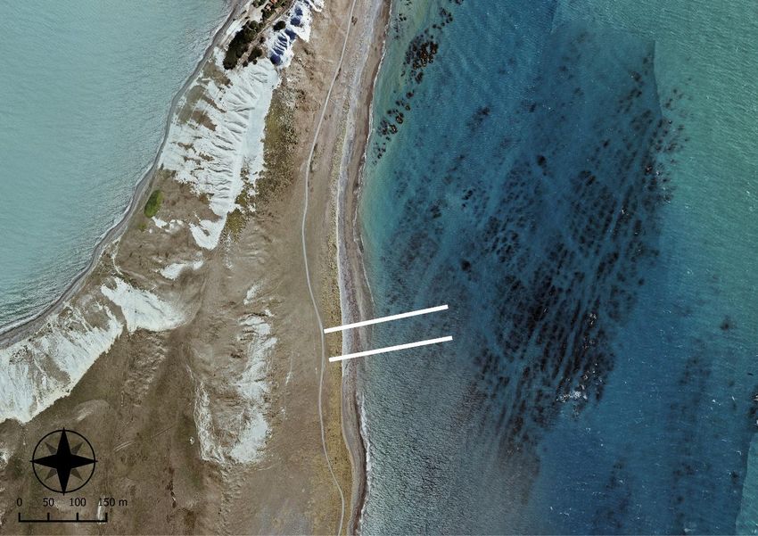
Abbreviations
MDC             Marlborough District City Council

DOC             Department of Conservation

ECPG            East Coast Protection Group

GIS             Geographic Information System

GPS             Global Positioning System

MBIE            Ministry of Business, Innovation and Employment

MDC             Marlborough District City Council

MPI             Ministry for Primary Industries

ORV             Off-Road Vehicle

QEII            Queen Elizabeth II

RECOVER         Reef Ecology and Coastal Values, Earthquake Recovery

RTK             Real-Time Kinematic

UAV             Unmanned Aerial Vehicle (drone)

UC              University of Canterbury
Contents
Executive summary .......................................................................................................................................... 1
1    Introduction ............................................................................................................................................. 3
     1.1    Earthquake recovery context ............................................................................................................... 3
     1.2    Scope and objectives ............................................................................................................................ 3
2    Background .............................................................................................................................................. 5
     2.1    Changes to Marlborough beaches ....................................................................................................... 5
     2.2    Reconciling recreational access and vehicle impacts ........................................................................... 5
3    Methodology ........................................................................................................................................... 8
     3.1    Dune vegetation mapping .................................................................................................................... 8
     3.2    Beach monitoring transects ................................................................................................................. 8
     3.3    Katipō surveys ...................................................................................................................................... 9
     3.4    Banded dotterel surveys .................................................................................................................... 10
     3.5    Off-road vehicle tracking .................................................................................................................... 10
4    Results and discussion ........................................................................................................................... 11
       4.1 Dune mapping and recruitment ......................................................................................................... 11
       4.2 Beach monitoring transects ............................................................................................................... 15
            4.2.1     Long Point............................................................................................................................. 15
            4.2.2     Aerial Beach.......................................................................................................................... 17
            4.2.3     Mussel Point ......................................................................................................................... 20
            4.2.4     Airstrip Beach ....................................................................................................................... 23
     4.3    Katipō surveys .................................................................................................................................... 25
     4.4    Banded dotterel nesting sites ............................................................................................................ 28
     4.5    Recreational activities and vehicle tracking ....................................................................................... 30
            4.5.1     Recreational activities and access points ............................................................................. 30
            4.5.2     Vehicle tracking .................................................................................................................... 30
            4.5.3     Future research and information gaps ................................................................................. 32
     4.6    Assessment of recreational impacts................................................................................................... 33
            4.6.1     Uplift effects on the shore profile ........................................................................................ 33
            4.6.2     Spatial overlaps between sensitive areas and recreational uses ......................................... 34
5    Summary of key findings ........................................................................................................................ 37
     5.1    Decline of pīngao ................................................................................................................................ 37
     5.2    Potential for opportunistic dune restoration ..................................................................................... 37
     5.3    Conservation of katipō on uplifted beaches ...................................................................................... 37
     5.4    Protection of shorebird nesting habitat ............................................................................................. 38
     5.5    Assessing change across multiple scales ............................................................................................ 38
6    Acknowledgements................................................................................................................................ 39
7    References ............................................................................................................................................. 39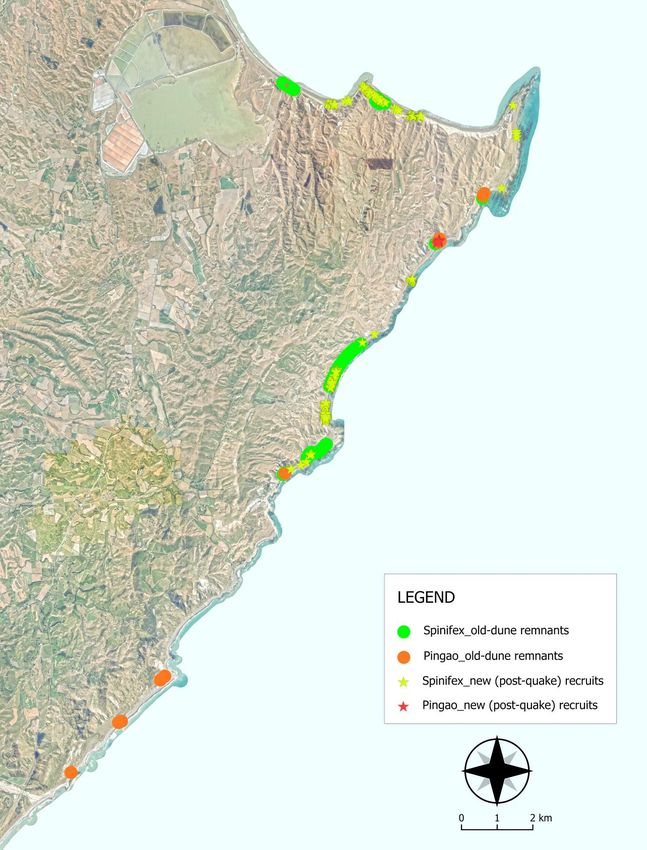
List of Figures
Fig. 1.1      Example of shoreline position changes associated with tectonic uplift at Long Point .......................... 5
Fig. 2.1      Off-road vehicle access has become more popular along the earthquake-affected coast as a result
              of new opportunities presented by beach uplift ................................................................................... 7
Fig. 3.1      Location of UC beach and reef monitoring sites on the Marlborough coast ......................................... 8
Fig. 3.2      Beach response monitoring ................................................................................................................. 10
Fig. 4.1      Whole-coast overview showing the location of pīngao and spinifex old-dune remnants and new
              (post- earthquake) recruits as recorded in summer 2019 ................................................................... 11
Fig. 4.2      Old-dune pīngao (Ficinia spiralis) remnants on the Marlborough coast ............................................. 12
Fig. 4.3      Examples of pre-earthquake spinifex (Spinifex sericeus) dune ecosystems on the Marlborough
              coast .................................................................................................................................................... 13
Fig. 4.4      Examples of spinifex (Spinifex sericeus) recruitment patterns on Marlborough’s uplifted beaches ... 14
Fig. 4.5      Location of beach monitoring sites at Long Point on the Marlborough coast. .................................... 15
Fig. 4.6      Preliminary results from beach monitoring at Long Point over the summers of 2018 and 2019 ........ 16
Fig. 4.7      Long Point beach .................................................................................................................................. 17
Fig. 4.8      Location of beach monitoring sites at Aerial Beach on the Marlborough coast .................................. 18
Fig. 4.9      Preliminary results from beach monitoring at Aerial Beach over the summers of 2018 and 2019 ..... 19
Fig. 4.10     Aerial Beach. ........................................................................................................................................ 20
Fig. 4.11     Location of beach monitoring sites at Mussel Point on the Marlborough coast ................................. 21
Fig. 4.12     Preliminary results from beach monitoring at Mussel Point over the summers of 2018 and 2019 .... 22
Fig. 4.13     Mussel Point beach .............................................................................................................................. 23
Fig. 4.14     Location of beach monitoring sites at Airstrip Beach on the Marlborough coast ............................... 24
Fig. 4.15     Airstrip Beach ....................................................................................................................................... 24
Fig. 4.16     Red katipō (Latrodectus katipo) on the Marlborough coast. ............................................................... 27
Fig. 4.17     Banded dotterels (Charadrius bicinctus bicinctus) on the Marlborough coast .................................... 28
Fig. 4.18     Visualisation of spatial density for banded dotterel (Charadrius bicinctus bicinctus) nesting
              ‘hotspots’ in 2018................................................................................................................................. 29
Fig. 4.19     Vehicle tracking patterns on the Marlborough coast. ......................................................................... 30
Fig. 4.20     Width of vehicle tracks recorded on Marlborough beaches above the post-earthquake high tide
              mark in the summer of 2019 ................................................................................................................ 31
Fig. 4.21     Effects of earthquake uplift.................................................................................................................. 34

List of Tables
Table 4.1 Summary of red katipō (Latrodectus katipo) densities within three morphologically defined
          zones at each of four study sites on the Marlborough coast in the summer of 2019. ........................ 25
Table 4.2 Red katipō (Latrodectus katipo) density differences within in two adjacent survey sites (each
          50 m in length) at Aerial Beach on the Marlborough coast in the summer of 2019. .......................... 27
Table 4.3 Summary of banded dotterel (Charadrius bicinctus bicinctus) observations made during
          whole-coast surveys in 2018 and 2019 between Marfells Beach and the Waima / Ure River
          on the Marlborough coast. .................................................................................................................. 28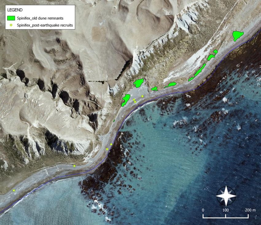
Executive summary
This report responds to a request from Marlborough District Council (MDC) for information on the coastal
environment, with a particular focus on supporting the development of a bylaw to address changes in
recreational use patterns that have occurred since the Kaikōura earthquake. We present a selection of
information from our earthquake recovery research that has a focus on understanding the impacts and
ongoing processes of change. Major impacts of the natural disaster are associated with vertical uplift of the
coastal environment, although ongoing erosion and deposition processes are also important.
In addition, interactions with human activities are important because they can exert strong influences on the
reassembly of ecosystems which is a critical aspect of outcomes over the longer-term.

Earthquake uplift caused widespread mortality of many coastal habitats and species (e.g., algal assemblages)
that are adapted to a relatively specific set of conditions, often associated with characteristic locations in
relation to the tidal range. In uplifted areas the intertidal zone has moved seaward leading to a physical
widening of many beaches. This has provided greater opportunity for off-road vehicle access to the coast and
has become particularly noticeable at headlands and other natural barriers that were previously impassable at
high tide.

Off-road vehicles pose threats to sensitive vegetation and wildlife unless appropriately managed. Achieving this
is assisted by an understanding of the specific impacts of vehicle use, which in turn requires information on the
location of sensitive areas. To ensure the best outcomes for earthquake recovery there is an urgent need to
assess and respond to the new spatial patterns, and to make plans to avoid conflicts where possible.

In our RECOVER (Reef Ecology and Coastal Values, Earthquake Recovery) project funded by the Ministry of
Business, Innovation and Employment (MBIE) and supported by the Ministry for Primary Industries (MPI) we
are collecting information on important conservation values and activities. Although research is continuing, this
report provides findings that include mapping of indigenous dune system remnants, recruitment of the
indigenous sand-binders spinifex (Spinifex sericeus) and pīngao (Ficinia spiralis) on uplifted beaches,
distribution of red katipō (Latrodectus katipo) within earthquake-affected dune systems, distribution of banded
dotterel / pohowera (Charadrius bicinctus bicinctus) nesting pairs to determine important areas, and spatial
overlaps with vehicle tracking measurements along the coast.

Take-away messages

Based on the information collected to date, key findings include:

   I.   There is strong evidence for the recent decline of pīngao in this area that should be of concern to
        coastal managers given its conservation status as an ‘at risk – declining’ species and as a Ngāi Tahu
        taonga species. The overall pattern includes an apparent lack of recruitment to replace old-dune
        pīngao remnants that are under threat from ongoing environmental change.

  II.   There is a unique opportunity to help re-establish pīngao and spinifex dune ecosystems through a
        strategic restoration approach that takes advantage of the uplifted beaches.

 III.   To assist recovery processes and opportunities, there is a need to avoid vehicle damage to existing
        dune faces and new dune establishment zones (which are close to the new high tide mark),
        particularly where spinifex and/or pīngao are present. Similarly, there is a need to avoid disturbance
        to reef platforms which are only slowly recovering and are highly fragile in their current condition.

                                                                                                                 1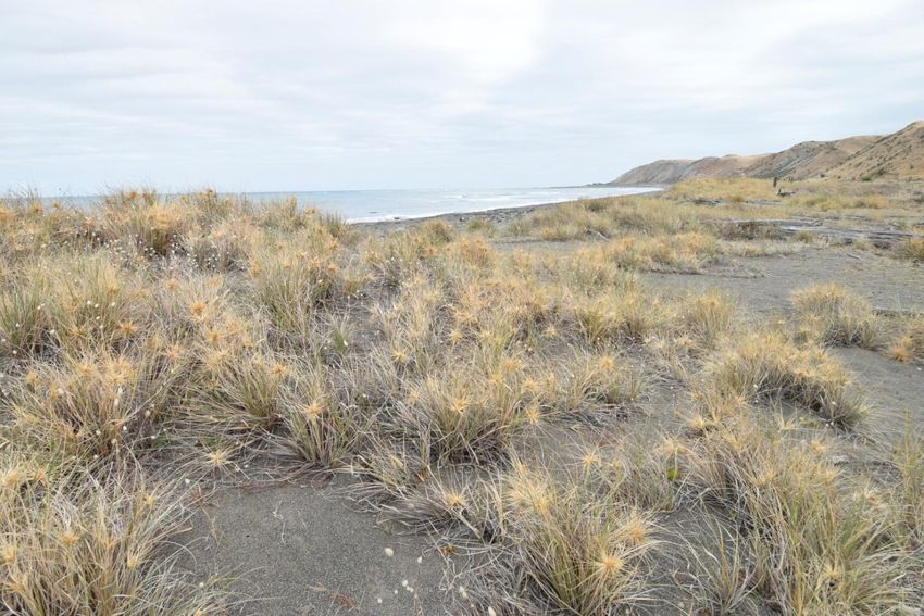
IV.   On this coastline, the fore-dune face is an important area for katipō and should be a focus for
          conservation efforts, especially where sparse vegetation types such as pīngao and spinifex are present.
          This creates an additional reason for protecting newly developing fore-dunes and assisting the re-
          establishment of indigenous dune systems. There are also major differences in katipō densities along
          the coast in similar habitats due to unknown factors which require further research.

    V.    The distribution of banded dotterel nesting sites includes several well-defined hotspots (clusters of
          nesting sites in close proximity) that are priority areas for protection. The specific impacts of vehicle
          use in these areas require further work to determine, but there is considerable overlap with the
          current pattern of vehicle tracking. Effective measures are needed to control threats from vehicle
          movements through techniques such as spatial planning to ensure a separation between vehicles and
          nesting areas during the breeding season.

    VI.   Bringing together information from studies at a variety of scales is needed for a comprehensive
          understanding of earthquake change and to assess the merits of new management proposals. These
          needs will continue beyond the life of the RECOVER project since many important recovery processes
          are only just beginning (e.g., new dune establishment and algal assemblage recovery). At the same
          time, ongoing disturbances, including natural disasters and climate change, will continue to affect the
          coast and are important aspects for longer term monitoring.

2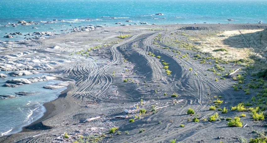
1       Introduction
1.1     Earthquake recovery context
The moment magnitude (Mw) 7.8 Kaikōura earthquake was one of the most complex earthquakes recorded to
date (Clark et al. 2017; Hamling et al. 2017a; Holden et al. 2017; Jiang et al. 2018). Energy was released over a
period of approximately 90 seconds, resulting in multiple ruptures that propagated in a north-easterly direction
and included offshore faults (Hamling et al. 2017a; Wallace et al. 2018; Xu et al. 2018). Many of the large
surface-level slips (10 m or more) had not been previously mapped or were believed to be inactive faults
(Hamling et al. 2017a). Variable degrees of coastal uplift (and some areas of subsidence) were recorded
throughout the earthquake-affected area. The general pattern involved uplift of up to ~ 6 m on the Canterbury
coast north of Kaikōura, and 0 – 2 m south of Kaikōura. Further north, the Marlborough coastline experienced
uplift of up to ~ 3 m associated with rupture of the Needles fault in the area between Wharanui Beach and
Marfells Beach (Clark et al. 2017; Hamling et al. 2017b; Jiang et al. 2018). Associated impacts in the coastal
environment included widespread mortality of marine life along ca. 130 km of coastline, mainly associated with
uplift effects (Alestra et al. 2019; Schiel et al. 2019; Schiel et al. 2018). Affected areas included the nearshore
marine environment and adjacent terrestrial areas, all of which are home to characteristic habitats and
resources on which people depend.

Recovery from natural disasters such as earthquakes highlights the importance of major step-change events in
shaping the landscape. Responses in the natural environment add an important dimension to disaster recovery
contexts (Orchard et al. 2020a; Orchard et al. 2020b). In this case, displacements effects have caused long-term
changes to the structure of the environment that are important to recovery processes, in addition to their
immediate effects. Due to the high level of interaction between people and the coast, the recovery of the
natural environment and resources is also likely to be assisted by interventions of various kinds. Understanding
the nature of impacts and direction of recovery trajectories enables the identification of opportunities and
potential issues that arise from trade-offs between competing uses and needs.

1.2     Scope and objectives
This report responds to a request from Marlborough District Council (MDC) for information on the coastal
environment, with a particular focus on supporting the development of a bylaw to address changes in
recreational use patterns that have occurred since the Kaikōura earthquake. These changes were summarised
in a recent MDC report (Marlborough District Council 2019b), and addressed in an issues-and-options paper
prepared to support the bylaw process (Marlborough District Council 2019a). The objective of this report is to
assist MDC and stakeholders in developing solutions for these needs and with a particular focus on the
proposed bylaw and related-decision making within the wider community.

In the following sections, we present a selection of information from surveys completed within the University
of Canterbury’s (UC) RECOVER project. RECOVER (Reef Ecology and Coastal Values, Earthquake Recovery) is a
four-year research programme funded by the Ministry of Business, Innovation and Employment (MBIE), and
supported by the Ministry of Primary Industries (MPI), that is evaluating post-earthquake recovery trajectories
in the coastal environment. Its geographic scope includes earthquake-affected coastal areas between Oaro in
the south, and Marfells Beach in the north.

The information is presented in an easily digestible format consisting of a series of comparable maps, along
with tables, graphs and site photographs to provide detail and highlight specific points.

                                                                                                                  3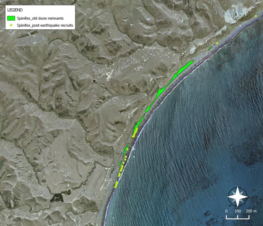
With respect to this report, surveys completed or currently underway within the RECOVER project on the
Marlborough coastline include:
Mapping of indigenous dune system remnants throughout the study area.
Recruitment of the indigenous sand-binders spinifex (Spinifex sericeus) and pīngao (Ficinia spiralis) on
the post-quake uplifted beaches.
Distribution of red katipō (Latrodectus katipo) within earthquake-affected dune systems.
Distribution of banded dotterel / pohowera (Charadrius bicinctus bicinctus) nesting pairs to determine
important areas along the coast, and
Vehicle tracking measurements throughout the study area.
We also provide some preliminary results from three longer-term beach monitoring sites (located at Mussel
Point, Aerial Beach and Long Pont), that illustrate current conditions and earthquake-related change on sandy
beaches typical of the wider coast.
Temporal aspects and limitations
It is important to note that most of our surveys were designed to support a three-year longitudinal study
aiming to characterise aspects of the ‘recovery trajectory’ for important values on the coast. A core research
strategy within the RECOVER project is to establish whether the recovery is ‘on track’ based on a limited period
of data collection. In this case, the research programme covers the period 2-5 years after the earthquake, even
though some aspects of the environment will take much longer to reach a ‘fully recovered’ state, and partially
depend on dynamic elements that are expected to undergo ongoing change. Despite its time-limited aspects,
this research strategy can help to identify barriers to recovery and other potentially undesirable changes that
could benefit from management interventions so that the best outcomes of recovery can be progressed or
achieved.
These aspects should be kept in mind when interpreting the results presented here. For some topics (e.g.,
beach responses to uplift) we have been able to include information on two points in time which provides an
indication of recovery processes and/or current trends. However, further research will be important to follow
continuing changes. We also provide some comments on information gaps and potential topics for further
research that are not currently addressed within the RECOVER project’s scope.
42 Background
2.1 Changes to Marlborough beaches
Impacts of earthquake uplift are the primary focus of this report, although there are also erosion and
deposition processes that are acting on the post-quake landscape and producing important additional changes.
In uplifted areas, shorelines have moved seaward, essentially creating new land above the reach of the tide. In
Marlborough, the changes have been manifested as a physical widening of many beaches that offers more
opportunity for off-road vehicle access to the coast (Fig. 1.1). This has become particularly noticeable at
headlands and other natural barriers that were previously impassable at high tide. Additionally, these beach
responses are driving ecological changes in the location of key ecosystems such as sand dunes and storm
beaches. Similarly, wildlife habitat and movements have been affected, although specific impacts are poorly
understood. Together, these changes confer unique challenges for coastal conservation and management in
earthquake-affected areas. To address these, there is an urgent need to assess and respond to the new spatial
configuration of important values and potential threats to their recovery and long-term persistence.
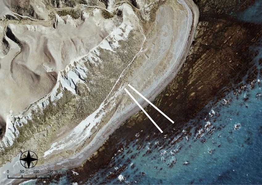
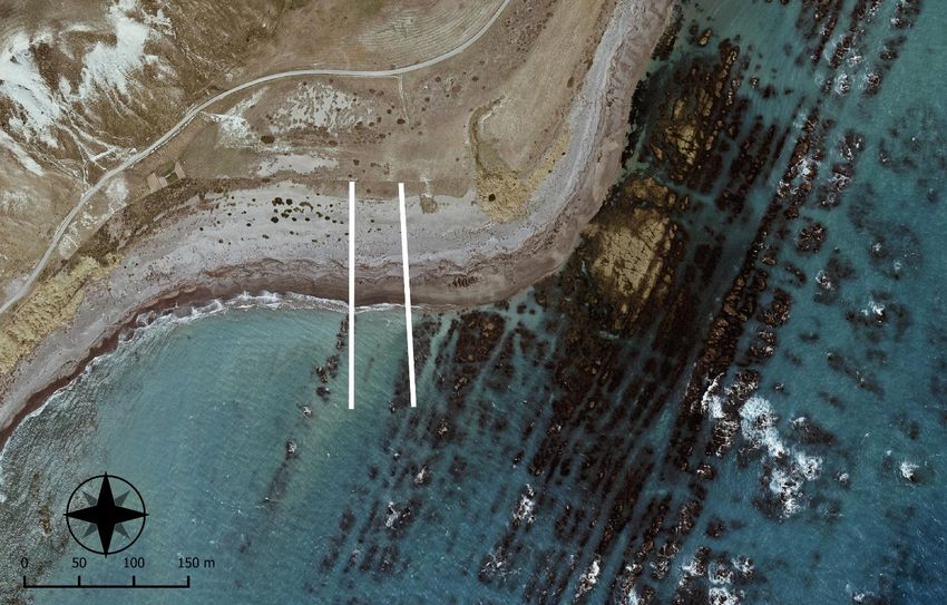
Fig. 1.1 Example of shoreline position changes associated with tectonic uplift at Long Point on the Marlborough coast
showing pre-quake imagery (left), and post-quake imagery (right).
2.2 Reconciling recreational access and vehicle impacts
Off-road vehicles (ORV) present many possibilities for accessing remote areas where there are no formed roads
(Fig. 2.1). In many parts of the world, ORV access is reportedly increasing, which may be attributable to a
greater awareness of the access opportunities through communication channels such as websites and social
media. In many cases, their cumulative effects have not been adequately managed. For example, Priskin (2003)
reported that the number of ORV access points had increased by 115% between 1965 and 1998 on the Central
Coast of Western Australia. In areas with a clearly defined ‘road’, drivers have also been observed to drive
5along the edge of the formed track, widening the damaged area (Davenport & Davenport 2006). Recent studies from Queensland showed that beach traffic is often more concentrated on the upper beach, but that the lower beach is used to varying degrees when exposed on lower tides (Schlacher & Thompson 2007). Several studies have reported detrimental impacts of ORVs on the structure and function of sand dune ecosystems, along with other impacts on a variety of beach-dwelling species. For example, damage to the foredune prevents the formation of new dunes, and beaches with ORV traffic have dunes that are set further back from the high tide line than beaches closed to ORVs (Houser et al. 2013). Impacts of ORV traffic include sand compaction, erosion, and destabilisation of existing dunes (Davenport & Davenport 2006; Hosier & Eaton 1980; Houser et al. 2013). Because dunes act as a barrier against storm surge and sea-level rise, damage by ORVs can have major consequences for houses, roads, and other structures located behind dune systems. The potential for damage to plant communities is an important component of ORV impacts on dunes because of the sand-trapping properties of dune plants. Groom et al. (2007) found much reduced densities of dune plants within areas open to OHVs in comparison to nearby areas where ORV traffic was prohibited under law. The impacts of ORVs included a reduction by up to 80% in the number of plant species, making rare species rarer and allowing dominant species to spread (Groom et al. 2007). In general, these vegetation-mediated impacts are additional to direct erosion effects of ORVs on dunes, and potentially more important in the longer term. In New Zealand, where the invasive Ammophila arenaria (marram grass) has displaced native sand- binders (Hilton 2006), ORVs may also cause a shift away from the native plant community and cause an overall decrease in the number of plant species present (Stephenson 1999), which are important aspects for the conservation of native dunes. Shorebirds are among the most studied wildlife in relation to the impact of ORVs. Several factors contribute to their vulnerability. For example, ORVs can crush the nests of shorebirds, which can be a particularly problematic for species that lay camouflaged eggs in simple, cryptic nests such as ‘scrapes’ (Stephenson 1999; Weston et al. 2012). On Marlborough beaches, such species include banded dotterel (pohowera/tūturiwhatu) (Charadrius bicinctus bicinctus) and South Island pied oystercatcher (Haematopus finschi). Disturbance by vehicles may also cause birds to reduce their feeding time, increase time away from the nest (exposing eggs and chicks to predators), and decrease the number of nests (Defeo et al. 2009). Studies in Queensland found that only 34% of ORV drivers slowed down or changed course when encountering a shorebird, although partial beach closings with signs or rope did reduce the rate of egg crushing (Weston et al. 2012; Weston et al. 2014). ORVs are also known to affect the beach invertebrate community. Crustaceans, polychaete worms, and clams all live in areas of the beach that are regularly used by vehicles (Davies et al. 2016; Schlacher et al. 2007; Schlacher et al. 2008). Even on low-trafficked beaches (e.g., with fewer than 50 vehicle passes per day), a 30 % reduction in invertebrate counts has been reported in comparison to untrafficked beaches nearby (Davies et al. 2016). In New Zealand, several studies have reported negative associations between ORV use and the health of sandy beach shellfish communities. Brunton (1978) showed that toheroa (Paphies ventricosa) actively move to the surface of the sand after being driven over by vehicles. It is suspected that toheroa confuse ORVs with crashing waves and rise to the surface to feed, which may expose them to predation by gulls (Brunton 1978). Other studies found that a significant percentage of juvenile toheroa are crushed in areas with vehicle use, which is in-part due to the distribution of juveniles being concentrated in the upper intertidal zone (Hooker & Readfearn 1998; Moller et al. 2014; Williams et al. 2013) (Hooker and Readfern 1998). Similarly, other species including the thin wedge shell (Macomona liliana), cockle (Austrovenus stutchburyi) and tuatua (Paphies donacina and P. subtriangulata) are found at depths
control these impacts include area-based measures, which have been implemented in several parts of New
Zealand to date. For example, the Tauranga City Council banned vehicle use on beaches (with some exceptions)
in 2007 using a bylaw that was subsequently updated in 2018 to provide for a permitting system to authorise
special cases (Tauranga City Council 2018). The Whangarei, Waimakariri, and Kapiti District councils have also
banned vehicles from certain beaches or segments of beaches (Kapiti Coast District Council 2009; Waimakariri
District Council 2016; Whangarei District Council 2009).

In relating the themes of the above review to the current situation in post-earthquake Marlborough, it is
important to note the lack of objective data to quantify relevant aspects, and these include the type and
volume of beach traffic, and its associated impacts. These information-poor aspects are common in New
Zealand beach management contexts due to the relatively few studies that have addressed relationships
between conservation and recreational use. In many respects, the following summary from Stephenson (1999)
remains applicable today:

   “The situation regarding vehicle impacts on the biota of the foreshore of sandy beaches in New Zealand
   remains uncertain. Although previous research provides a guide for management strategies with respect to
   vehicle use of sandy beaches and coastal dunes in New Zealand at a general level, some local research is
   considered desirable. Future research into vehicle impacts on the biota of sandy beaches and coastal dunes
   in New Zealand should include fundamental research to further underpin decision-making processes, and
   applied research to address problems and monitor the results of management at specific sites.”

Along several sections of the Marlborough coast, rocky reefs are also present seaward of sandy beaches and
these are accessible to vehicles on lower tides. Although driving along a reef may alleviate impacts to the beach
and dune ecosystems, it is likely to hinder recovery of the already severely affected algal community. For
example, previous studies have shown that trampling causes a significant (up to 90%) reduction in cover of the
dominant alga Hormisira banksii (Neptune’s Necklace) on upper intertidal reef platforms. This species can take
several years to return to its undisturbed state following a single disturbance event (Lilley & Schiel 2006; Schiel
& Taylor 1999; Tait & Schiel 2011). These aspects illustrate the need to develop local solutions to address
recreational access and ORV use.

Fig. 2.1 Off-road vehicle access has become more popular along the earthquake-affected coast as a result of new
opportunities presented by beach uplift. Note tyre tracks from the dune vegetation above high tide to low tide reefs.

                                                                                                                    7
3 Methodology 3.1 Dune vegetation mapping Dune ecosystem types were mapped across the entire study area in December 2018, with a follow-up survey the following summer. Each survey was conducted over four days and covered the full coastline from the Waima / Ure River in the south to Marfells Beach in the north. These field surveys had two major objectives: quantifying the established (‘old-dune’) remnant systems and measuring the establishment of any new post-earthquake recruits of two priority indigenous sand-binding species, spinifex (Spinifex sericeus) and pīngao (Ficinia spiralis). Old-dune remnants were mapped as polygons using hand-held GPS units in the field. New recruits were measured as point locations. Additional measurements included the size of each colony, plant community composition, condition and threats. 3.2 Beach monitoring transects Long-term monitoring sites were established at several beaches along the Marlborough coast in 2018 (Fig. 3.1, 3.2). On sandy beaches, the monitoring focussed on beach and dune responses to uplift effects, and surveys to support beach restoration initiatives as part of the Beach Aid collaborative project between the UC, MDC, Department of Conservation (DOC), and East Coast Protection Group (ECPG). Additional study sites were established on pea- gravel beaches such as Airstrip Beach (Fig. 3.2b) to support other work on the spatial distribution of nesting sites for banded dotterel / pohowera (Charadrius bicinctus bicinctus). This beach also supports a small colony of sea holly (Eryngium vesiculosum) that is currently listed as a ‘nationally vulnerable’ species in the New Zealand Threat Classification System (de Lange et al. 2018). Fig. 3.1 Location of UC beach and reef monitoring sites on the Marlborough coast. 8
Surveys at sandy beach sites are designed to monitor change in pre-earthquake spinifex dune systems to assess
their responses to earthquake impacts, with the exception of the Aerial Beach site. For the latter, the long term
transects are primarily designed to monitor the main trial site for the Beach Aid project, as there are no
remnant spinifex dunes at this site.

At each monitoring site, two shore-perpendicular sampling transects were established. An origin point for the
first transect (Transect 1) was established at a random point in the backdune swale within the remnant spinifex
dune system (where present). At most sites this location was in the transition zone between the dune system
and more stable terrestrial vegetation types (typically grassland). The second transect was cast 50 m to the
south at Aerial Beach. At Mussel Point and Long Point the distance between transects was 30 m and 20 m,
respectively, with the closer spacing being necessary due to the small size of the spinifex remnant dunes that
were the focus of the monitoring.

3.3     Katipō surveys
A pilot survey was completed in the 2019 summer to support an evaluation of the implications of uplift for red
katipō (Latrodectus katipo) with regard to the potential for longer term impacts associated with dune system
changes, and more immediate restoration opportunities associated with local initiatives such as Beach Aid.
Katipō spiders are a flagship wildlife species for beach management in New Zealand and the earthquake-
affected area is a previously reported population hotspot (Anderson & Anderson 2019; Patrick 2002). Katipō
are the only native venomous spiders in New Zealand and have a restricted coastal distribution mainly
associated with sandy beach ecosystems (Forster & Forster 1973; Griffiths 2001). There is also considerable
evidence of decline since the 1970s (Hann 1990), which contributes to their current conservation status of ‘at
risk – declining’ in the New Zealand Threat Classification system (Sirvid et al. 2012).

The particular focus of the pilot survey was the development of a methodology for spatially-explicit
assessments of katipō abundance to enable the comparison of different areas within sand dune ecosystems. In
our case, the areas of interest include the potential dune migration zone created by the uplift of sandy
beaches. The specific objective of the pilot survey was to assess the spatial variation (‘patchiness’) of katipō
populations at four sandy beach sites to inform the design of a larger scale survey to be completed in the 2020
summer in collaboration with local researcher Mark Anderson. The four sites chosen were Long Point, Aerial
Beach, Mussel Point, and Marfells Beach, all of which will be included in the larger scale assessment.

At each site, a survey area of 30 m x 50 m was established with the long axis parallel to the foredune crest,
which was further subdivided into three 10 m x 50 m areas representing different zones within the dune
system. The ‘foredune face’ zone was defined as a 10 m wide belt seaward of the foredune crest, which at
most sites included all or the majority of the front dune face. The ‘foredune back-slope’ zone was defined as a
10 m wide belt landward of the same position (foredune crest), and the ‘backdune swale’ zone was another 10
m wide band immediately adjacent to landward. The latter typically included a swale landform and/or
continuation of the foredune back-slope. At all sites, the foredune crest was readily identifiable and relatively
linear within the survey area.

All of the above areas were thoroughly searched for katipō webs which have a characteristic architecture
(Griffiths 2001), and the results of May-June surveys are presented here. The position of all webs was recorded
with a hand-held GPS and field notes, and the coordinates were subsequently checked and refined with the
assistance of 0.2 m post-quake imagery. Katipō occupancy was established for all webs found and individuals
were recorded as either juvenile or mature, with sex also recorded for the latter, as recommended in recent
studies (Costall & Death 2009, 2010).

                                                                                                                 9
3.4 Banded dotterel surveys Banded dotterel census surveys were completed for the Waima / Ure River to Marfells Beach coastline in November 2018 and 2019. A mobile GPS application (Gaia GPS) was employed in the field to record the location of individual birds and breeding pairs along with associated attributes including bird behaviour, presence of juveniles, and position on the beach. Nesting pairs were identified on the basis of territorial behaviour. Territorial overlaps were discriminated by having two observers following the movements of adjacent breeding pairs to assess their characteristic ward-like behaviour, which includes the ‘escorting’ of intruders to beyond the territorial range, in addition to distraction displays such as rat-runs when intruders are in closer proximity to the nest or chicks. Waypoints were positioned at the estimated midpoint of the territory based on these observations and at the location of first sighting for individual birds. Additional searches were made for nests at two locations (Ward Beach and Canterbury Gully) to verify the correlation between the above behavioural signs and the presence of nesting pairs. Four pairs of birds were tracked at each location and in all cases either a nest or young chicks were present within the territory as identified using the above technique. 3.5 Off-road vehicle tracking Vehicle tracking measurements were made at periodic intervals throughout the study area during the dotterel census survey completed in 2018 and 2019. At each monitoring point the cumulative width of visible vehicle tracks (as measured in the shore-perpendicular direction) was recorded to the nearest metre. This measure reflects the distance between the tyre tracks of individual vehicles, summed across the shore profile, or in the case of heavily tracked areas, the cumulative width of the beach that was tracked. To avoid biases introduced by the presence of recent tracks on the lower beach (below the position of high tide) which were only visible at some sites and dependent on the state of the tide, only tracking above the high tide line is reported here. Additional notes were taken on transition points between areas of noticeably different tracking patterns, for example, where tracks were seen to fan out or converge in response to barriers and topographic changes, and at the location of turnaround areas and access points. Fig. 3.2 Beach response monitoring. (a) Beach monitoring transect at Mussel Point. (b) RTK-GPS survey underway at Airstrip Beach to support UAV (drone) mapping of the uplifted beach. 10
4       Results and discussion
4.1     Dune mapping and recruitment
Comprehensive mapping of old-dune remnants in the study area shows that the distribution of indigenous
dune vegetation is highly patchy for both of the priority sand-binding species (spinifex and pīngao) in this
section of the Marlborough coast (Fig 4.1).

Fig. 4.1 Whole-coast overview showing the location of pīngao and spinifex old-dune remnants and new (post-
earthquake) recruits, as recorded in summer 2019. Note that the northern end of the survey area was at Marfells
beach and extensive stands of spinifex are known to be present further north in Clifford Bay.

                                                                                                                  11
Pīngao
The small number of pīngao was particularly notable, with only old-dune remnants found in four areas, and
new recruits recorded only at Canterbury Gully. There are also clear signs of recent decline in some of the
existing colonies, such as at Canterbury Gully where old root mats provide evidence of much greater vegetation
cover that has since perished (Fig. 4.2b). Similar effects are apparent at Airstrip Beach (Fig. 4.4c), where
historical photos illustrate a massive decline in pīngao cover in recent years. Taken together, the results
suggest a trend of ongoing decline associated with recent pīngao mortality and a lack of recruitment across the
coast as a whole.
A B
C
Fig. 4.2 Old-dune pīngao (Ficinia spiralis) remnants on the Marlborough coast. (a) example of a small isolated pīngao
dune that has resisted marram invasion south of Long Point. (b) pīngao root mats are signs of recent decline at
Canterbury Gully. (c) at Airstrip Beach the pīngao colony is now confined to the front face of an old terrace (on right)
and has declined drastically in recent years.
Spinifex
Although remnant spinifex dunes are found throughout the study area, relatively large remnants are restricted
to three main areas south of Marfells Beach (Fig. 4.1). In all three areas (Long Point, Booboo Stream, and
Mussel Point), old-growth spinifex is found on sandy beach terraces and hill slopes that are now located a
considerable distance inland. This illustrates the potential resilience of these ecosystems in the face of uplift
events, which have been relatively frequent in this area in geological time (Ota et al. 1996). It is likely that these
colonies represent relatively old dune systems that have successfully resisted marram invasion over the years.
Recruitment from the older remnants is reflected in the presence of smaller patches at a variety of locations
across the study area (Fig. 4.3). These are generally located in the vicinity of marram-dominated dunes but
have established in favourable areas. In nearly all cases, these spinifex patches are located at the seaward limit
of the pre-quake vegetation, indicative of a competitive advantage over marram in this position. The
distribution of these smaller patches has an apparent association with proximity to old-dune remnants. For
example, only two such patches are located within the large area of coastline between Mussel Point and
Canterbury Gully that is also a prominent gap in the old-dune distribution.
12Across the coast as a whole, a total of 262 recruits of height > 20 cm were recorded in 2019, all of which were
located seaward of the pre-earthquake dune toe on the uplifted beaches. The pattern of recruitment exhibits
strong spatial patterning that highlights the role of old-dune areas as seed sources (Fig. 4.3, 4.4). This aspect
has likely played an important role in the persistence of spinifex in the area over recent decades, and is
consistent with the pattern of smaller colonies that appear to have become established more recently,
although in general remain very scarce. There is potential for spinifex dune expansion in areas of uplift if
spinifex recruitment is successful relative to that of potential competitors such as marram grass.
A B
C
Fig. 4.3 Examples of pre-earthquake spinifex (Spinifex sericeus) dune ecosystems on the Marlborough coast. (a) the
old-growth spinifex dune system at Mussel Point extends a considerable distance inland on the face of an old beach
terrace that has remained dry and sandy. (b) a typical small colony located north of Long Point at the position of the
pre-earthquake dune toe. These small colonies are mostly clustered around old-growth seed sources. (c) the
extensive old-dune system in the Booboo Stream area has retained a high degree of natural character. Several large
sections of the dune system are dominated by spinifex with a considerable area in relatively unmodified condition.
Factors contributing to the resilience of these old-growth systems are an important current focus.
13A
B
Fig. 4.4 Examples of spinifex (Spinifex sericeus) recruitment patterns on Marlborough’s uplifted beaches. (a) striking
recruitment pattern near the Booboo Stream old-dune remnant correlated with being downwind of prevailing wind
direction and concentrated close to the new post-earthquake high tide mark on the uplifted beaches. (b) similar
downwind effects from the old-dune remnants south of Long Point in 2019.
144.2 Beach monitoring transects
This section provides preliminary results from transect surveys at three sandy beach monitoring sites: Long
Point, Aerial Beach and Mussel Point. Additional details are provided for a fourth site (Airstrip Beach), which is
a gravel-dominated beach being investigated as a discrete case study.
4.2.1 Long Point
The Long Point study site is characterised by a several spinifex remnants that extend the full width of the dune
system in some places, or otherwise occupy pockets between marram-dominated dunes (Fig. 4.5). Many of the
spinifex remnants are interspersed with marram grass. This would be a good topic for additional monitoring to
assess the potential for further invasion, which requires better knowledge of trends over time. However, some
spinifex runners have extended into relatively open areas of sand (particularly to the south of the study site)
indicating that ongoing dynamics are also important influences on spinifex presence and persistence. Large
areas of intertidal reef were uplifted by up to 3 m in this section of the coast and this has created marked
changes in the topography of the upper intertidal zone (Fig. 4.5).
T1
T2
Fig. 4.5 Location of beach monitoring sites at Long Point on the Marlborough coast.
Vegetation monitoring for the 2018-2019 period showed that the old dune system has been relatively stable
(Fig. 4.6, 4.7). On this section of coast the old dune system now extends to edge of a steep gravel beach profile
that occupies the area between the old dune toe (ca. 60 m on the transects) and a reef platform (ca. 100 m).
Post-quake vegetation has established to ca. 90 m on the transect s (Fig. 4.6a). The new dune zone on the
uplifted beach is only sparsely vegetated (< 20% cover), with the majority of the vegetation consisting of early
coloniser species and a few spinifex runners extending into this area from the old dune toe, primarily in
transect 1. These runners account for the higher percentage cover of the ‘new dune landward’ zone in transect
1 when compared to transect 2 (Fig. 4.6b), and are also reflected in the mean vegetation height data (Fig. 4.6c).
15(a) Dune width (d) Shore profiles
Transect 1 1
Transect
(b) Vegetation percentage cover
(c) Mean vegetation height
Transect
Transect 2 2
Fig. 4.6 Preliminary results from beach monitoring at Long Point over the summers of 2018 and 2019. (a) dune width, (b) percentage cover, (c) mean vegetation height, (d) shore profiles.
The new dune zone is defined as the vegetation seaward of the estimated position of the old (pre-earthquake) dune toe, and is split in half (new dune landward and seaward) in graphs (b)
and (c). Error bars are standard error of the mean for 2 x 2 m plots surveyed within each area.
16This suggests the potential for spinifex dune movement to seaward and the available space being largely
determined by decision on vehicle routes in relation to its natural seaward limit. Vehicle tracking on this stretch
of beach is influenced by the relatively narrow area between the reef and dune toe, which provides high tide
access on a sloping beach-face. On the new high tide beach the vehicle tracking footprint occupies at least two-
thirds of the total area and has increased slightly between 2018 (16 m) and 2019 (18 m). However, a relatively
well-formed track at the edge of the reef platform is the most used vehicle route and is available for most of
the tidal range, depending on swell conditions
A B
C D
Fig. 4.7 Long Point beach. (a) vehicle tracking on the uplifted beach showing steep shore profile. (b) view looking
north from transect 1. (c) looking north from the fore-dune crest on transect 2. In this area the relatively broad dune
system remains dominated by spinifex (Spinifex sericeus) although it is interspersed with marram (Ammophila
arenaria). (d) spinifex runners extending seaward from the position of the pre-earthquake dune toe on the uplifted
beach.
4.2.2 Aerial Beach
Aerial Beach site is situated a few hundred metres south of the Cape Campbell lighthouse (Fig. 4.8). It is
characterised by a steep, dense marram fore-dune with a sandy beach below. The back-dune area is fenced off
from adjacent farmland and is also marram-dominated with no spinifex or pīngao present. However, a
relatively large new spinifex colony (ca. 8 x 10 m) was already present on transect 1 in the summer of 2018,
located near the position of the post-quake high tide mark. This is likely to have become established soon after
the 2016 earthquake along with two other similar recruits to the south. Other new spinifex recruits have been
observed on this beach since 2018, some of which have not survived. The latter is possibly related to drying out
effects, as well as the potential impacts of browsing (e.g., rabbits), direct disturbance (e.g., vehicles) and
inundation at high tide. Since monitoring began, however, there have been no major erosion events from
storm tides or swell and this is reflected by the increase in vegetation cover on the uplifted beach above the
level of typical high tides.
Vegetation monitoring in 2018-2019 showed that the pre-earthquake marram dune system has occupied the
same footprint over this period (Fig. 4.9a), although with some erosion of the front dune face having occurred
on transect 2 (Fig. 4.9d). However, the most striking result involves vegetation establishment in the ‘new dune’
17area, which has increased substantially between 2018 and 2019. This is reflected by increases in vegetation
cover (Fig. 4.9b) and mean height (Fig. 4.9c) within this area, as well as seaward expansion of the area of new
vegetation on both transects (Fig. 4.9a). The latter is associated with the recruitment of new plants close to the
post-earthquake high tide mark that have yet to be removed by a storm event (but could be in the future).
T1
T2
Fig. 4.8 Location of beach monitoring sites at Aerial Beach on the Marlborough coast. The cottages at Cape Campbell
can be seen near the top of the picture.
The ‘new dune’ zone is now around 40 m wide on transect 2, and slightly less on transect 1 (Fig. 4.9a).
Vegetation cover is rapidly increasing in this zone, especially in the seaward half where it has now reached 50%
on transect 2 (Fig. 4.9b). The increased vegetation cover is now also having structural effects through the
trapping of wind-blown sand. Accumulation of sand in the ‘new dune’ zone was indeed detectable in the shore
profiles between 2018 and 2019 (Fig. 4.9d) and indicates the creation of a new dune habitat on the uplifted
beach. Further progression of this process in presence of sand-binding species is expected to continue building
a new dune system due to the abundance of sand supply. Human impacts on vegetation (both positive and
negative) are therefore a key consideration at this time. At present, both marram and spinifex recruits have
become established in the ‘new dune’ zone (Fig. 4.10).
Measurements of vehicle tracking showed markedly different results for the two transects between years. On
transect 1, tracking increased from 4 m in 2018 to 15 m 2019, whereas on transect 2 tracking was similar
between years (7m for 2018, 6m for 2019). These results, which are specific to the high tide beach, represent a
relatively small tracking footprint when compared to other study sites (e.g., Long Point), even though vehicles
are frequently observed on this section of the coast. This may indicate a tendency towards use of the well-
defined tracks that are present on the upper beach, or alternatively greater use of the lower tide beach (or a
combination of both). It is possible that the majority of ORV users in the Cape Campbell area have targeted
lower tide conditions and may have come and gone within these periods since the access point at Marfells
Beach is not far away. There is a greater chance that vehicles travelling further south (e.g., to Long Point) would
encounter higher tide conditions even if this was not planned due to the greater distance and travel time
involved.
18(a) Dune width (d) Shore profiles
(b) Vegetation percentage cover Transect 1
(c) Mean vegetation height
Transect 2
Fig. 4.9 Preliminary results from beach monitoring at Aerial Beach over the summers of 2018 and 2019. (a) dune width, (b) percentage cover, (c) mean vegetation height, (d) shore profiles.
The new dune zone is defined as the vegetation seaward of the estimated position of the old (pre-earthquake) dune toe, and is split in half (new dune landward and seaward) in graphs (b)
and (c). Error bars are standard error of the mean for 2 x 2 m plots surveyed within each area.
19A B
C D
Fig. 4.10 Aerial Beach. (a) looking north towards Cape Campbell from transect 1 in 2018. (b) a similar view in early
2020 showing vegetation establishment in the new dune zone following marram control to support the Beach Aid
project. (c) view looking south from transect 2 in 2018. (d) similar view looking south in early 2020.
4.2.3 Mussel Point
Mussel Point is located to the east of Marfells Beach campground. The lower beach has a more gentle profile
than the beaches south of Cape Campbell due to the sheltering effect of the Cape (Fig. 4.11). The dune system
is characterised by a marram-dominated fore-dune. There is also a well defined secondary dune at the study
site which supports stands of knobby club rush (Ficinia nodosa). In addition, two small patches of spinifex are
present on the fore-dune crest (one on each transect line) in the otherwise marram-dominated system, and
there is a third patch further east near the mouth of Fishermans Creek. These are interpreted as being
relatively new colonies since there is a relatively large old-growth spinifex dune system on the sandy hillside
behind the beach (see Fig. 4.4) that is protected under a QEII National Trust covenant.
Vegetation monitoring for 2018-2019 showed that a ‘new dune’ zone of around 10 m in width has developed
on the Mussel Point beach in response to earthquake uplift, which is less than at the other study sites (Fig.
4.12a). Within this area, vegetation cover has increased at transect 1, but not at transect 2 (Fig. 4.12b). This
reflects the growth of several spinifex runners that have extended into the new dune zone from the pre-
earthquake dune toe (Fig. 4.13a), and are also beginning to catch sand as seen in the shore profiles (Fig. 4.12d).
This is also reflected by the vegetation cover increases being mainly seen in the landward half of the ‘new
dune’ zone), in contrast to Aerial Beach where vegetation establishment in this zone has been greatest within
the seaward half. The latter is associated with the arrival of new recruits that have established near the
position of the new (post-earthquake) high tide mark. At Mussel Point there has been some plant
establishment in the seaward half of the ‘new dune’ zone (Fig. 4.13b), but our monitoring to date shows that
this band of vegetation has not increased appreciably since 2018 (Fig. 4.12b, c). Field observations have shown
that there is considerable turnover in this area (some plants dying and other new plants establishing), which
largely explains these effects.
20You can also read