Groins, sand retention, and the future of Southern California's beaches - asbpa
←
→
Page content transcription
If your browser does not render page correctly, please read the page content below
Groins, sand retention, and
the future of Southern California’s beaches
By
Gary Griggs,1 Kiki Patsch,2 Charles Lester,3 and Ryan Anderson4
1) Earth and Planetary Sciences Department, University of California Santa Cruz
2) Environmental Science and Resource Management Department, California State University Channel Islands
3) Ocean and Coastal Policy Center, University of California Santa Barbara
4) Department of Anthropology, Santa Clara University
ABSTRACT KEYWORDS: Groins, sediment
Beaches form a significant component of the economy, history, and culture of transport, coastal structures, beach
southern California. Yet both the construction of dams and debris basins in coastal stabilization.
watersheds and the armoring of eroding coastal cliffs and bluffs have reduced sand
supply. Ultimately, most of this beach sand is permanently lost to the submarine Manuscript submitted 16 August 2019;
canyons that intercept littoral drift moving along this intensively used shoreline. revised & accepted 22 November 2019.
Each decade the volume of lost sand is enough to build a beach 100 feet wide, 10 feet
deep and 20 miles long, or a continuous beach extending from Newport Bay to San from the California Coastal Commission.
Clemente. Sea-level rise will negatively impact the beaches of southern California The options being considered in these
further, specifically those with back beach barriers such as seawalls, revetments, planning discussions range from more
homes, businesses, highways, or railroads. traditional shoreline protection such as
shore-parallel structures like seawalls
Over 75% of the beaches in southern California are retained by structures,
and revetments to beach replenishment
whether natural or artificial, and groin fields built decades ago have been important
strategies and new ideas for managed
for local beach growth and stabilization efforts. While groins have been generally
retreat. On a parallel track, the state
discouraged in recent decades in California, and there are important engineering and
Coastal Conservancy has been encourag-
environmental considerations involved prior to any groin construction, the potential
ing shoreline adaptation projects that rely
benefits are quite large for the intensively used beaches and growing population of
on “natural” or “green” infrastructure,
southern California, particularly in light of predicted sea-level rise and public beach
also termed “living shorelines.” These
loss. All things considered, in many areas groins or groin fields may well meet the
might include dune-backed beaches or
objectives of the California Coastal Act, which governs coastal land-use decisions.
constructed oyster beds within estuarine
There are a number of shoreline areas in southern California where sand is in short
or bay environments.
supply, beaches are narrow, beach usage is high, and where sand retention structures
could be used to widen or stabilize local beaches before sand is funneled offshore by Within this setting of renewed think-
submarine canyons intercepting littoral drift. Stabilizing and widening the beaches ing and planning about alternative shore-
would add valuable recreational area, support beach ecology, provide a buffer for line management strategies, this article
back beach infrastructure or development, and slow the impacts of a rising sea level. takes a fresh look at groins as a strategy to
C
protect and maintain sandy beaches, with
alifornia is the nation’s most resources. California has a long history of a particular focus on southern California.
populous state with over two- proactive beach management, including The article reviews the general history of
thirds of its 40 million people sand replenishment and the construc- California’s beaches and discusses basic
living in coastal counties (including those tion of groins to increase the size of its beach dynamics. It also reviews the his-
bordering San Francisco Bay). California beaches. Unfortunately, despite these ef- tory of groins in California and considers
also has the largest ocean economy of any forts, climate change-driven sea level rise the prospects for increasing their use as
state, calculated at about $46 billion/year now threatens to literally drown many of a beach management strategy. The article
(Eastern Research Group 2015) of which California’s sandy beaches. One recent suggests that depending on the context,
the single biggest contributor is tourism study projects the significant loss of two- groins are deserving of more in-depth
and recreation ($17.6 billion or 38%). thirds of southern California’s beaches consideration as an important beach
The state’s beaches are a significant part by 2100, assuming that the developed management and adaptation strategy,
of the tourism and recreation economy, backshore remains fixed in its current particularly in conjunction with beach
particularly in southern California with location (Vitousek et al. 2017). replenishment.
its 18 million residents and millions of
In the last five years, dozens of Cali- SOUTHERN CALIFORNIA
annual visitors.
fornia’s coastal communities have started BEACH TRENDS
To the degree that we can increase the to assess different ways to protect their Many southern California beaches
amount of littoral sand and beach width, shorelines, including sandy beaches, show historical trends of accretion, or
we are improving both shoreline pro- supported by a new planning grants widening, due to large additions of sand
tection and enhancing our recreational program and sea-level rise guidance from coastal construction and marina
Page 14 Shore & Beach Vol. 88, No. 2 Spring 2020
Figure 1. Summary of beach replenishment projects in California (excluding those associated with harbor
maintenance dredging and bypassing). Source data: National Beach Restoration Database (ASBPA 2019).
and river channel dredging projects be- an additional 51 projects with an average Pacific Decadal Oscillations. For beaches
tween the 1930s and the 1980s (Flick volume of 385,000 cubic yards, added 22 influenced by shore normal engineering
1993; Wiegel 1994). These far exceeded million cubic yards (all totals exclude structures (some breakwaters and jet-
the natural sand supply from the heavily routine harbor maintenance dredging ties, for example), no such correlations
altered rivers and streams of the Santa and sediment bypassing at harbors). exist, but net changes over the prior 75
Monica, San Pedro, and Oceanside lit- Over the years, with new construction years revealed two interrelated types of
toral cells and created wider than natural projects waning, the number of artificial variation. First, hard structures predict-
beaches. As of 1992, over 130 million replenishment projects, total volume of ably disrupt littoral drift within cells with
cubic yards of sand had been added to sand added to the beaches, and average accretion occurring updrift and erosion
these beaches from construction projects volume of sand per project has shown a typically occurring downdrift of jetties
(Flick 1993). decreasing trend throughout California and breakwaters. Sand bypassing and
(Figure 1). other forms of artificial replenishment
Sand placement on the beaches from
have usually countered these effects,
shoreline construction projects in south- However, despite the reduction in ar-
although the beach widening and sand
ern California peaked from the 1940s to tificial replenishment, the impoundment
storage resulting from the construction
the 1960s with nearly 100 million cubic of sand by dams and debris basins, and
of engineering structures does become
yards of sand placed on beaches from 31 the channel alterations in coastal water-
a more permanent change. Second, the
different projects with an average project sheds, no littoral cell-wide, long-term, net
longevity of artificial replenishment
placing over two million cubic yards. erosional or depositional beach trends
reflects the volume and grain size of fill
During the 1960s and 1970s, 58 projects were identified in southern California by
introduced and whether or not retention
resulted in the placement of 33 million Orme et al. (2011) from comparisons of
structures are present. In most cases, the
cubic yards of sand with an average proj- long-term aerial photographs. Relatively
effects of replenishment without reten-
ect volume of 460,000 cubic yards. During natural beaches, lacking major human
tion structures are short-lived, with nour-
the 1980s and 1990s, 51 replenishment impacts, revealed modest cyclic narrow-
ished beaches eroding over a few years,
projects placed 29 million cubic yards ing and widening related respectively
leading to repeated and costly cycles of
with an average project size of 500,000 cu- to El Niño and La Niña climate forcing,
replenishment (Flick 1993; Wiegel 1994;
bic yards. From 2000 until today (2019), and longer-term trends weakly related to
Griggs and Kinsman 2016). Beaches will
Shore & Beach Vol. 88, No. 2 Spring 2020 Page 15
Figure 2. Littoral cells and submarine
canyon sinks in southern California.
tend to return quickly to their equilib-
Figure 3. Submarine
rium profile in balance with the average
canyons cutting into the
sediment supply, grain size, water depth,
continental shelf along
California’s coastline.
wave energy, and shoreline orientation
(Bruun 1954; Dean et al. 2002; Griggs and
Kinsman 2016). Climate change and pro-
jected sea-level rise will change the water
depth and perhaps wave energy, which is
why coastal geologists are generally pro-
jecting the accelerated retreat or narrow-
ing of sandy beaches where the backshore
is unable to retreat inland in response to
rising water levels due to armor or back
beach development (Vitousek et al. 2017).
LITTORAL CELLS
AND LITTORAL DRIFT:
SAND SOURCES AND SINKS
The shoreline of southern California
between Santa Barbara and San Diego
can be divided into a series of distinct,
essentially self-contained, littoral cells
or beach compartments (Figure 2; In-
man and Frautschy 1966). These com-
partments are geographically limited
and consist of a series of sand sources
(primarily rivers, streams, and eroding
coastal bluffs) that provide sand to the
beaches, longshore sand transport (which
is dominantly to the southeast along the
southern California coastline), and sand
sinks (such as submarine canyons and
coastal dunes) where sand is lost from
the shoreline. While historically coastal
dunes were a significant sink, today with
Page 16 Shore & Beach Vol. 88, No. 2 Spring 2020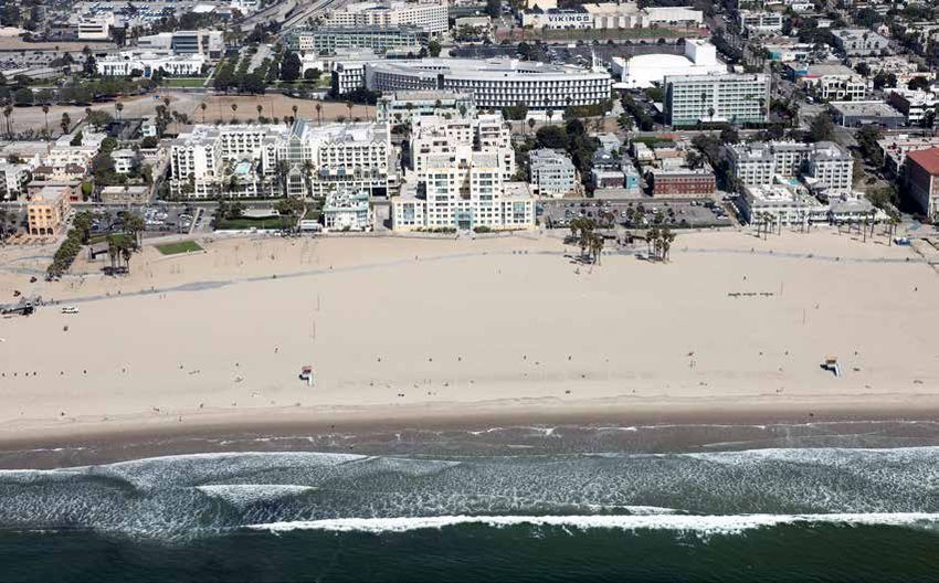
coastal development and alterations in
the sand budgets limiting the extent of
dunes along the coast, submarine canyons
form the major sink. Sediment within
each littoral cell includes the sand on
the exposed or dry beach as well as the
finer-grained sand that lies just offshore
and that moves on and offshore seasonally
and alongshore as littoral drift.
Fifteen submarine canyons carve into
California’s continental shelf, nine of
which are located in southern California
including Hueneme, Mugu, Dume, Santa
Monica, Redondo, Newport, Carlsbad,
Scripps, and La Jolla canyons (Figures 2
and 3) with canyon heads close enough
to the shoreline (inner edges range from
33 feet to five miles offshore; Figure 4)
to interrupt a portion of the alongshore
littoral drift and funnel sediment into
deep offshore basins (Normark et al. Figure 4 (above). Proximity of the submarine canyon heads to the shoreline.
2009). As a function of the proximity of a
canyon head to the shoreline, the regional Figure 5 (below). Approximate annual sand capture for submarine canyons
sediment budget, and the location of the funneling more than 10,000 cubic yards of sand per year offshore (Patsch
canyon within a littoral cell, only five and Griggs 2005; Moffatt & Nichol and Everts Coastal 2009, Everts Coastal
of California’s 15 canyons intercept and 2002; and Everts and Eldon 2005)
funnel more than 10,000 cubic yards of
sand annually offshore into deep water,
essentially removing the sand from the
littoral budget; four of these canyons are
located in southern California (Hueneme,
Mugu, Redondo, and Scripps submarine
canyons; Figure 5). The average amount
of littoral sand lost permanently into
southern California submarine canyons
each year is about 1,400,000 yds3, based
on an analysis of California’s littoral cell
budgets and balancing inputs and outputs
(Patsch and Griggs 2006).
A summary of the sand budgets for
all of California’s major littoral cells was
compiled by Patsch and Griggs (2006).
This report provides a comprehensive
evaluation of the: 1) volumes of sand
provided by all sources; 2) littoral drift
rates within littoral cells developed us- Considering the challenges in obtaining enough sand to build a beach 100 feet
ing long-term averages of annual harbor these values or making these measure- wide, 10 feet deep and 20 miles long, or
dredging volumes as proxies; and 3) sand ments, these estimates align well with the a beach extending from Newport Bay to
lost to sinks, as well as how various hu- assessments of Patsch and Griggs (2006). San Clemente.
man activities have altered the natural Assuming a beach profile out to an aver-
Sand losses to submarine canyons
sand inputs. age depth of closure with a volume to
are permanent. Once sand moves into
beach area conversion of one cubic yard
In a different study, Everts and Eldon the steeper slope of a submarine canyon
of sand per square foot of beach, the value
(2005) used a combination of beach sand head, it doesn’t return to the littoral zone
(1,400,000 yds3) obtained by Patsch and
losses, sand bypass dredging, measure- (Everts and Eldon 2005). The former lit-
Griggs is equivalent to a beach 100 feet
ments from diver surveys in submarine toral sand will move downslope, either
wide, 10 feet deep and two miles long lost
canyons and littoral sediment budget through slow creep/sand flow or through
every year into the submarine canyons
analysis to estimate that from 1,250,900 periodic and more rapid turbidity cur-
along the southern California coast. Thus,
yds3 to 1,512,000 yds3 of annual sand rents, and ultimately will be deposited in
each decade, the shoreline extending
is lost to southern California canyons. a deep-sea fan thousands of feet below
from Santa Barbara to San Diego loses
Shore & Beach Vol. 88, No. 2 Spring 2020 Page 17
Figure 6. Location map.
sea level. These fans can be very large and Vista in western Santa Barbara County HISTORIC RESPONSES
contain hundreds of millions to billions (Figures 6 and 8), the Rincon coast of TO COASTAL RETREAT
of cubic yards of sand (Everts and Eldon Ventura County (Figure 6), Broad Beach AND NARROW BEACHES
2005; Emery 1960), which attests to the in western Los Angeles County (Figures 6 To provide some long-term per-
enormous quantities of beach sand that and 9), and extensive reaches of northern spective on the retreat of the southern
have been permanently lost to the deep San Diego County. There are multiple California coastline, at the end of the last
sea, and to the tens of thousands of years reasons for these differences along the ice age about 18,000 years ago, sea level
over which these processes have been southern California coastline, which was 350-400 feet lower and the coast of
operating. include shoreline orientation and lack southern California was at the edge of
of littoral drift barriers, rates of littoral the continental shelf, anywhere between
While there are sections of the south-
drift, human impacts on sand input, and one mile and 12 miles west of the present
ern California coast where the beaches
shoreline processes, to name some of the shoreline. As glaciers retreated and ice
are very wide and stable (the low-lying,
most significant (Flick 1993; Wiegel 1994; melted, and ocean water warmed and
originally dune-backed shoreline of Santa
Everts and Eldon 2000; Everts Coastal expanded, sea level rose relatively rapidly
Monica Bay is a good example; Figures 6
2002; Patsch and Griggs 2006; Orme et al. (about one-half an inch/year or four feet
and 7), there are other areas where, for
2011; Griggs and Kinsman 2016; Griggs per century) between 18,000 years ago
a variety of reasons, beaches are narrow
and Patsch 2018). and 8,000 years ago. This led to the re-
or virtually nonexistent, including Isla
treat of the southern California coastline,
Page 18 Shore & Beach Vol. 88, No. 2 Spring 2020
Figure 7. The low-lying shoreline and broad beach of Santa Monica in Los Angeles County, California.
along with its fronting beaches, at average and passive erosion (flooding the beaches in armored settings (Vitousek et al. 2017)
rates in the range of six inches to six feet where they are backed by armor or other with resultant reduction of beach visita-
per year. About 8,000 years ago the rate of development) with continuing sea-level tion and the associated economic losses
sea-level rise slowed to perhaps one mm/ rise (Griggs 2005). (Pendleton et al. 2012).
year and shoreline retreat significantly
The California Coastal Commission There are essentially two ways to
slowed, although winter wave attack, par-
(CCC) has been regulating proposed increase the extent or width of beaches:
ticularly during high tides, continued to
shoreline protection for nearly 50 years, 1) increase the amount of sand reaching
erode the cliffs and bluffs along the coast.
and has been specifically concerned with the shoreline or on the beach naturally or
With the shoreline development of the
mitigating the negative impacts of armor- artificially, or 2) reduce littoral transport
past century, erosion began to threaten
ing structures for at least the last three or retain the sand such that more of it
both coastal infrastructure and private
decades (Lester and Matella 2016; Cali- remains on the beach. While beach re-
development.
fornia Coastal Commission 1997). With plenishment has been used extensively for
Armoring the coast, usually with increasing attention on the impacts of decades along the sandy shorelines of the
either riprap revetments or seawalls, has global sea-level rise, including the possi- Atlantic and Gulf coasts of the U.S., this
been the most common approach to deal- bility of accelerated erosion of California’s has not been the case in California. With
ing with coastal erosion in California. By sandy beaches, the CCC has heightened several recent exceptions, adding sand
2018, 148.7 miles (or 13.8% of the state’s its review of new proposals for additional artificially to California beaches has been
entire 1,100-mile coastline) had been ar- armoring. This includes renewed focus on primarily opportunistic where sand from
mored, and 88.1 miles or 38% of the more the original language in the Coastal Act of new marina construction or maintenance
intensively developed coast of southern 1976, which sought to allow only shore- dredging of existing harbors or stream
California had been protected by some line protection for structures that were in channels, or from large construction proj-
form of armor (Griggs and Patsch 2019a). existence at that time (California Coastal ects in coastal dunes where sand has been
However, seawalls and revetments are Commission 2018a; Lester 2005). Given placed on adjacent or nearby beaches as a
built to protect cliffs, bluffs, backshore this heightened regulatory concern, it convenient location to dispose of the sand
development or infrastructure, and not may become increasingly difficult to get (Flick 1993; Wiegel 1994).
to protect beaches. In fact, armoring new armoring approved along the state’s
The major exception to this opportu-
structures can have significant negative coastline (Griggs and Patsch 2019b). Ad-
nistic disposal has been two recent San
impacts on beaches, including placement ditionally, with a continuing rise in sea
Diego County replenishment projects
losses, reduction of sand supply from level, the process of passive erosion will
where collectively 3.5 million cubic yards
eroding bluffs (Runyan and Griggs 2003), lead to progressive loss of sandy beaches
Shore & Beach Vol. 88, No. 2 Spring 2020 Page 19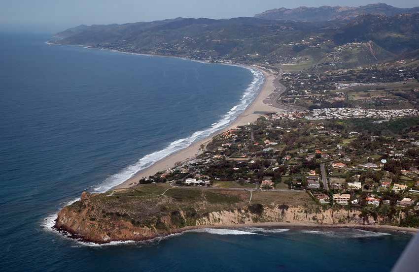
Figure 8. The narrow cliff-backed
beach of Isla Vista in Santa
Barbara County, California.
of sand were dredged from offshore sites beaches, and 2) efforts to return the Future sea-level rise will pose addi-
and pumped onto a number of San Di- natural transport of sand to the shoreline tional problems and eventually further
ego County beaches at a total cost of $46 through dam removal. While the latter is limit the effectiveness of both coastal
million (Regional Beach Sand Projects an important objective with clear benefits, armoring and beach replenishment. A
— RBSP I and II; Griggs and Kinsman long and complicated environmental recent synthesis of future sea-level rise for
2016). Without any structures to retain analysis, exhaustive government agency California (Griggs et al. 2017), requested
the sand, however, most of this sand was review and approvals, and rising costs, by the state’s former governor and based
eroded from the subaerial beach during have made dam removal projects nearly on new research on the potential for ice
the first or second year following place- an endless process. The Carmel River San sheet collapse in Antarctica, included
ment. Without either regular or repeated Clemente Dam was successfully removed sea-level projections for 2030, 2050, and
replenishment, or the construction of after two decades of assessment and plan- 2100. These projections were also given
retention structures such as a groin or ning. Dedicated and continuing efforts to probabilities based on different future
series of groins, there is no reason why remove the Matilija Dam on the Ventura greenhouse gas emission scenarios. This
in an area with naturally narrow beaches River, which is essentially full of sediment report was followed by a sea-level rise
and a high littoral drift rate that any (about 3 million cubic yards of sand), guidance document (California Ocean
artificially added sand should remain on began in the mid-1990s and the hope now Protection Council 2018), which used
the exposed beach or widen it for any is for removal by 2025 — 30 years later the same future projections, but took
extended period of time. — and at a cost now estimated in excess them one step further and designated
of $100 million. Dam removal is without different probabilities as Low Risk Aver-
Considerable time, effort, and expense
question a worthwhile goal that we need sion, Medium-High Risk Aversion, and
has been invested along the southern
to continue to pursue, but experience in Extreme Risk Aversion in order to provide
California shoreline in both 1) searching
California and elsewhere has made it clear a risk perspective for each sea-level rise
for and then recovering, transporting,
that such projects will never be quick, value as a guide for both state agencies
and distributing new sources of sand
easy, or inexpensive to accomplish. and local governments. Analysis from
from offshore or onshore to nourish
Page 20 Shore & Beach Vol. 88, No. 2 Spring 2020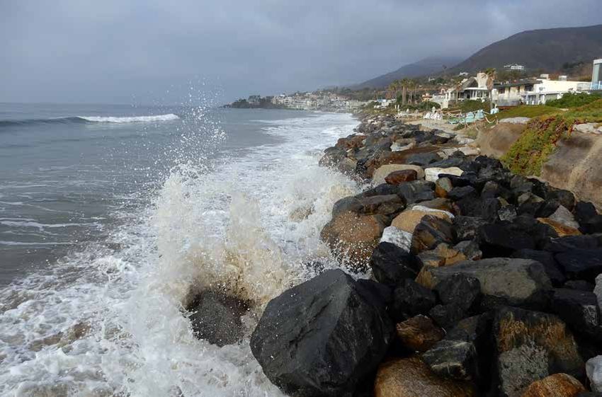
Figure 9. King-tide, nonexistent
beach at Broad Beach in Los
Angeles County, California,
December 2018.
the U.S. Geological Survey (USGS) show Table 1. have had major secondary or negative
that perhaps two-thirds of southern Cali- Number of groins by county in downdrift effects. The words “groin” and
fornia’s beaches will disappear by 2100 California. “jetty” have also been used interchange-
from the effects of projected sea-level rise Number ably by many without understanding
(Vitousek et al. 2017). County of groins their inherently different purposes. This
Marin County 6 may be due to a lack of familiarity with
THE HISTORY OF GROINS Santa Cruz County 1 groins specifically, particularly among
ALONG THE SOUTHERN
Santa Barbara County* 1 coastal residents and users. Kinsman and
CALIFORNIA COAST
Ventura County* 11 Griggs (2016) found that nearly 20% of
An approach used in the past, but
Los Angeles County* 16 users surveyed between 2008 and 2010
which has created down-drift impacts
Orange County* 8 were not familiar with the term “groin.”
or other side effects at some locations,
San Diego County* 6 In southern California, it is common for
has been the emplacement of groins.
Total number of groins in CA 49 many users to refer to all rock structures
Several groin fields were built years ago in
* Total number of groins in SoCal 42 that are perpendicular to shore as jetties.
southern California where beaches were (84%) The Newport groin field, which is known
narrow, and these have proven effective
among the local surf population as the
in either stabilizing or widening beaches or stabilize beaches with the benefits
“Newport Jetties,” is a case in point.
at Ventura, Malibu, Santa Monica, and that wider beaches provide (Griggs 2003;
Newport Beach. While there are a num- Everts Coastal 2002). Currently, there are There are important differences be-
ber of critically important design consid- 49 groins in California (Figure 10), 84% of tween groins and jetties, however. Jetties
erations and precautions (height, length, which are located in the state’s southern are nearly always built in pairs with the
location, material, spacing, and orienta- counties (Table 1) with an average length intended purpose of stabilizing entrance
tion of groins, location within a littoral of approximately 300 feet (Figure 11). channels to ports, harbors, or marinas or
cell, as well as the sand volumes needed to maintain inlets. They are usually many
Groins have been successfully used at
to fully charge or initially fill the area up- hundreds to thousands of feet long, and
a limited number of locations in southern
coast of groins following construction), while they often trap or retain littoral
California, but have often been lumped
these structures basically mimic natural sand, their primary goal is to prevent
with the much larger breakwaters and jet-
littoral drift obstructions or barriers and sand from entering an entrance channel
ties as coastal engineering structures that
have the potential to significantly widen or inlet. Groins, on the other hand, are
Shore & Beach Vol. 88, No. 2 Spring 2020 Page 21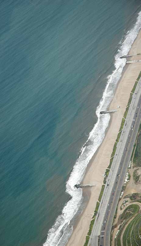
concerns about the potential impacts of
Figure 10. Location of groins on beach aesthetics, surfing, and
groins in California. other resources, groins have not usually
been looked upon favorably by many as
an approach to building or stabilizing
beaches.
Ventura Pierpont Groins
Pierpont or San Buenaventura State
Beach, one of the main beaches in the
City of Ventura (Figure 6), is partially
supplied by sand from the immediately
upcoast Ventura River, as well as littoral
drift from streams at least as far west as
Point Conception and possibly beyond
(Patsch and Griggs 2006). However, like
many southern California watersheds,
rainfall and therefore sand discharge
are very intermittent (Brownlie and
Taylor 1981). In addition, two large
dams, Matilija and Casitas, impound
about 47% of the entire Ventura River
watershed and form major sand traps for
fluvial sand transport. As a result, during
major flood years, large volumes of sand
are delivered to the coast, but these years
are interspersed with years of low flow
and minimal sand discharge. Significant
shoreline damage occurred in about
1936, followed by the very large 1938
floods, which brought over 650,000 yds3
of sand to the shoreline (Brownlie and
Taylor 1981). Reduced sediment yields
from the Ventura River during the dry
interlude between 1948 and 1959, which
also happened to follow the construction
of the Matilija Dam, were largely respon-
sible for causing the shoreline between
the Ventura and Santa Clara rivers to
erode 300 feet landward over that time
period. To offset this, an erosion control
project was completed between 1962 and
1967 at San Buenaventura State Beach,
comprising seven rock groins (400-540
feet long; Figure 14) and placement of
880,000 cubic yards of sand on a beach
120-260 feet wide and two miles long
(Orme 2005). This beach has been main-
Figure 11. Distribution of groin lengths in California. The average length of tained in part with sand dredged from
groins in California is approximately 300 ft. the downcoast Ventura Marina.
usually considerably shorter and have a have a direct impact on sand movement, Las Tunas Groins
primary purpose of trapping or retaining these impacts tend to be smaller rela- One of the oldest groin fields in
littoral drift in order to build, stabilize, tive to those of jetties and breakwaters, California was placed in 1929 along the
or widen a beach. Single groins can be as well as shorter in duration, starving Las Tunas shoreline, a strip of eastern
constructed or a groin field consisting down-coast beaches only for as long as Malibu next to Topanga Canyon. Thir-
of a number of groins can be built along the groin is not fully charged, or filled teen groins, from 80 to 455 feet long
a stretch of shoreline. Without ques- to capacity. Once charged, sediment will consisting of steel sheet-piles capped
tion, jetties and breakwaters that have migrate around the tip of the structure with concrete were constructed (Fig-
created many of California’s ports and (Figure 13). Still, perhaps as a result of ure 15) in order to widen the beach to
harbors have had major impacts on lit- the perceived similarities of groins with partially protect the homes built along
toral drift (Figure 12). While groins also jetties and breakwaters, as well as other the shoreline as well as the Pacific Coast
Page 22 Shore & Beach Vol. 88, No. 2 Spring 2020
Figure 12. A breakwater at Santa Barbara trapped millions of cubic yards of sand
following construction in 1928-1930 Courtesy: Bruce Perry, California State University Long Beach.
Highway. There was no Coastal Com- Groins of Santa Monica transport along the Santa Monica coast
mission, no California Environmental What may have been the first groins and marked the end of Woodard’s experi-
Quality Act (CEQA) or environmental built along the southern California ments and engineering career.
review process at that time. The groins coastline were those constructed at the
There is also a separate set of groins
did work effectively for a number of years northern end of Santa Monica Bay near
known as the Bel Air Club groins in the
along a stretch of shoreline that has only Will Rogers State Beach in about 1925,
far northern corner of Santa Monica Bay
a very modest littoral drift rate due to although not without some controversy
where the shoreline makes a turn from
the general lack of upcoast sand supply, (Figure 6). Wilkie Woodard, chief en-
the east-west trending Malibu coast to the
a supply which has now virtually disap- gineer for the Santa Monica Mountain
SSE trending curve of Santa Monica Bay.
peared (Griggs and Patsch 2018). Over Park Company (a property development
Beaches were narrow here initially, but
the subsequent 90 years, however, the firm), performed some pioneer work on
there were concrete groins constructed
concrete deteriorated, along with parts groins and the attributes that determine
that took advantage of rock reefs and sim-
of the steel sheet-piles, leaving a jagged their effectiveness. With the observation
ply extended them (Herron 1986). These
and dangerous set of metal projections that some bedrock reefs extending out
proved very effective in providing a stable
extending across the shoreline (Figure from the shoreline could collect sand
and wider beach than originally existed,
16), which led to safety concerns, law- and thereby widen the beach Woodard,
although it is not clear who built these
suits, and proposals for removal and the who was described by William Herron
groins or when. Today, however, there are
construction of new groins. Some rem- (1986; who was himself a pioneer coastal
six rock groins in this area that have effec-
nants of the original sheet-piles still exist, engineer) as “a real estate agent turned
tively widened and stabilized this section
however. In 2003, the CCC approved a engineer,” realized that this was a good
of shoreline (Figure 18). Downcoast, as
State Lands Commission proposal to way to build valuable coastal real estate
the Santa Monica Bay shoreline gradually
remove five of the groins. Ultimately, over for his employer. He actually built some
comes into equilibrium with the dominant
900 feet of dilapidated groin material was steel sheet-pile and timber structures that
direction of wave approach, the beaches
excavated and removed from the beach, he could adjust with boards to block sand,
become much wider and stable, such that
with an average sheet-pile height of five or let sand through, and also change the
there is no apparent impact of the groins
feet. In addition, divers removed 265 feet crest level and observe what happened.
on the down drift beaches. It is not known
of sheet-pile from the surf area to increase This ultimately led to a lawsuit by the City
when these groins were built, but they
the safety of the beach. One groin was of Santa Monica based on the adverse
were in place by at least 1972 (Figure 19).
capped and restored (Figure 17). effects the groins were having on sand
Shore & Beach Vol. 88, No. 2 Spring 2020 Page 23Much of Newport Beach in Orange
County was built on a barrier spit and
is significantly affected by large waves
generated by southern hemisphere storms
and also tropical storms off Baja Califor-
nia, in large part because the Newport
Beach coast is south facing and lacks
protection from the offshore Channel
Islands. Shoreline erosion is often most
serious in summer as a result. In the
summer of 1965, for example, the beach
eroded 165 feet before being stabilized
by sandbags just five feet from property
lines. Similarly, severe erosion occurred
again in 1968. The greatest threat has been
at West Newport Beach; this area has been
the site of numerous beach protection
and restoration efforts, mainly Corps
of Engineers regional projects. Eight
rubble mound and sheet pile groins were
installed in the 1960s and 1970s (Figure
22), and several replenishment projects
have added more than 1.5 million yds3 of
sand to this beach. In 1991, another 1.3
million yds3 of sand, dredged from the
Santa Ana River, were used to build an
offshore sand mound to feed the beaches
(Sherman and Pipkin 2005). These groins
have proven effective in stabilizing the
beach along the barrier spit for 50 years.
The eight groins at West Newport Beach
were built immediately updrift of the
Figure 13. A. Groin field constructed perpendicular to the beach with the head of Newport Submarine Canyon. As
intention to retain sand. B. With a net littoral drift direction to the right in a result of these groins as well as other
the diagram, sand accumulates on the updrift side of the structure causing upcoast engineering structures, very little
the beach to accrete, and may erode the beach on the downdrift side of the sand is now presumed lost to Newport
structure depending upon groin width and spacing. C. Once the groin is Canyon. Regardless of the amount of sand
charged, or reaches its capacity to interrupt littoral drift, sand will bypass the transported into the canyon, the groins
groin and once again provide sand to the downdrift beaches. and beach nourishment have so far been
Flick (2013) in a report to the City of are quite close together and this is the effective in maintaining a wider beach
Los Angeles on coastal issues related to largest groin field anywhere in southern with both structural and recreational
future sea-level rise describes the groins California that the authors have discov- benefits.
at the western half of Will Rogers State ered. We have, however, been unable to
Oceanside Groins
Beach as built prior to the 1960s, but uncover any history on this groin field
The coastline and sand supply in
that the groins were dilapidated and were beyond the two photographs in Figures
Oceanside (Figure 6) has been impacted
slated for removal. He also states: “This 20 and 21.
by multiple structures that have been built
segment of shoreline is highly instructive in
Newport Beach Groins throughout the 20th century. One key
that it illustrates successful and relatively
The fluvial sand supply to the urban- event was the damming of Lake Henshaw
unobtrusive groin beach width stabiliza-
ized southern California coastline has in 1922, which severely reduced the sand
tion structures that will almost certainly
been significantly reduced by the con- supply to the city’s beaches (Kuhn and
become increasingly and widely necessary
struction of flood control dams and debris Shepard 1984). In the 1940s, the federal
if area beaches are to be preserved in the
basins in the contributing watersheds, as government constructed a breakwater
future.”
well as the lining of most of river channels and boat basin for Camp Pendleton,
Surfside Timber Groins with concrete for stabilization (Brownlie located just north of the city. In the early
An aerial photograph from the UCLA and Taylor 1981; Orme et al. 2011; Sher- 1960s, the City of Oceanside constructed
Spence Collection taken in 1935 (Figure man and Pipkin 2005). Beaches also a small boat harbor. Combined, these
20) shows extensive beach development undergo changes over time in response structures have contributed to severe
backing a narrow beach with at least 45 to sediment reduction, as well as storm downcoast erosion and beach sand loss
wooden groins along the coast of Surf- occurrence and intensity, and also signifi- (Kuhn and Shepard 1984; Flick 2005;
side, south of Long Beach. These groins cant El Niño events (Young et al. 2018). USACE 1991). In order to help control
Page 24 Shore & Beach Vol. 88, No. 2 Spring 2020Figure 14. Pierpont Beach, 1926 (left), and Pierpont Beach, today (right).
sediment flow near the harbor, the city
installed a groin alongside the San Luis
Rey River mouth in 1961, in addition
to a submerged groin in 1962 (Perdomo
2004). The San Luis Rey River groin,
which was extended to 915 feet in 1968,
has played an important role in helping
to retain sand on the popular beach in
front of Oceanside Harbor for decades.
Overall, Oceanside has experienced
considerable beach sand loss throughout
the 20th and 21st centuries (Orme et
al. 2011; Young et al. 2018; Flick 2005).
Today, many of the beaches south of
Oceanside pier are experiencing high Figure 15. Original Las Tunas groin field along the eastern Malibu shoreline
rates of erosion with narrower beaches (in background).
during high tides and storm events
(Figure 24). A substantial portion of
Oceanside’s coast is lined with riprap, and
many sections have little to no beach dur-
ing much of the year (Orme et al. 2011).
Since the late 1970s, the city has explored
options for beach sand stabilization, rang-
ing from rock revetments to seawalls and
groin systems (Hales 1978; Kuhn and
Shepard 1984; Moffatt and Nichol 2001).
In the early 1980s, consultants proposed
several potential groin-based options for
sand retention along the city’s southern
shores. To date, the City of Oceanside has
not constructed any new groins.
IMPORTANCE OF LITTORAL
DRIFT BARRIERS TO SOUTHERN Figure 16. Dilapidated sheet-pile groins left hazards along the shoreline at
CALIFORNIA BEACHES Las Tunas Beach, Los Angeles County, California
Many of California’s beaches exist
because of natural littoral drift barriers
such as headlands and points (Figure
25). Over 75% of the beaches in southern
California are retained by structures,
whether natural or artificial:
Shore & Beach Vol. 88, No. 2 Spring 2020 Page 25Figure 17 (left). Repaired
groin, Las Tunas Beach,
Los Angeles County,
California. Photo: Kiki
Patsch.
Figure 18 (below). Groins
along the northern end of
the Santa Monica shoreline.
Courtesy: Bruce Perry,
California State University
Long Beach.
Two-thirds of those structures are
headlands, surface-piercing or
submerged reefs, near-coast sub-
marine canyons, rock stream deltas,
and various types of irregular ba-
thymetry. The remaining third are
jetties, groins, and shore-parallel
and shore-normal breakwaters.
By regulating the breaking wave
height, the angle waves make with
the shoreline, and the path sediment
takes as it moves along the coast,
beach-retention structures promote
wider and more stable beaches than
would otherwise exist. Performance
and adverse impacts vary from place
to place depending upon a complex
interdependence of the type and size
of the retention structure, the way
in which it regulates the longshore
component of energy flux, and local
orientation of the coast (Everts and
Eldon 2000).
In addition to continuing efforts to
remove dams that no longer serve their
intended purpose by virtue of being filled
with sediment, the use of sand retention
structures along the southern California
shoreline needs to receive a fresh look as a
possible management option when plan-
ning for sea-level rise. It will be important
to consider littoral drift rates and location
with a littoral cell, the local orientation of
the shoreline, sand supply (both natural
and artificial), as well as the engineering
specifications of the retention structures
in order to reduce the impact on the
downdrift shoreline.
GROINS AND THE CALIFORNIA
COASTAL COMMISSION
When the original California Coastal
Act was written and then passed by the
Page 26 Shore & Beach Vol. 88, No. 2 Spring 2020Figure 19. Groins at the northern end of Santa Monica shoreline in 1972. Courtesy: California Coastal Records Project. Legislature in 1976, California had been in a cool or negative phase of what we now understand as the Pacific Decadal Oscillation (PDO). That cool era began in the mid- to late-1940s and continued until about 1977-1978. These three de- cades were characterized by relatively calm coastal conditions with few large El Niño events and storms with little shoreline wave damage (Griggs et al. 2005). This same roughly three-decade long period was precisely the era when California’s population grew rapidly and many coastal communities were devel- oped. The state’s population grew from 9.3 million in 1945 to 22.8 million in 1978, or a 240% increase. In 1978, however, the climate over the North Pacific and along California’s coast transitioned rather abruptly to a warm, or positive, PDO period charac- terized by larger and more frequent El Niño events. The elevated sea levels and more damaging coastal storms took their Figure 20. Residential development at Surfside in 1935, looking southward. toll on coastal development and infra- The beach is very narrow and broken up by wooden groins. Spence structure (Griggs et al. 2005; Griggs and Collections. Reproduced courtesy: Dept. of Geography, University of Patsch 2019a; Griggs and Patsch 2019b); California Los Angeles. Bromirski et al. 2011). Shore & Beach Vol. 88, No. 2 Spring 2020 Page 27
The Coastal Act is a comprehensive law
covering coastal management concerns
ranging from public access and habitat
protection to growth management and
protection of rural agricultural landscapes
(Lester 2013). With respect to coastal
hazard issues, the planning leading up to
the Coastal Act was also comprehensive,
and it included discussion of both “sand
movement and shoreline structures” and
“development in hazardous areas” that
supported eight very detailed proposed
policies (Lester and Matella 2016; CCZCC
1975). When it came time to draft the
Coastal Act, these policies were distilled
down into two broad coastal hazard
policies. One policy, Coastal Act Section
30253, stated a goal that new development
minimize coastal hazard risks to life and
property and avoid new shoreline armor-
ing (Lester 2005). The second policy,
Coastal Act Section 30235, attempted to
address the circumstances under which
any engineered structure that interfered
with shoreline processes could be ap-
proved. It states in part:
“Revetments, breakwaters, groins,
Figure 21. Surfside ~late 1940s. This is the same area as shown in Figure 20, harbor channels, seawalls, cliff
but the groins have been destroyed or removed except for some residual retaining walls, and other such
pilings in the foreground that presumably supported the timber groins. construction that alters shoreline
Figure 22. Groins along the Newport Beach shoreline
Courtesy: California Coastal Records Project.
Page 28 Shore & Beach Vol. 88, No. 2 Spring 2020Figure 23. Oceanside groin, which was built in 1961 and extended in 1968. Photo: Ryan Anderson
Figure 24. South Oceanside, showing riprap and narrow to nonexistent beaches. Image taken from just south of
Wisconsin Street in July 2019. Photo: Ryan Anderson.
processes shall be permitted when structure is to protect either a “coastal- was likely a direct effort to potentially
required to serve coastal-dependent dependent” development such as a boat provide for groins or other structures that
uses or to protect existing structures harbor, or an existing development or may serve this purpose given that it was
or public beaches in danger from public beach endangered by erosion, as generally understood that revetments,
erosion, and when designed to elimi- long as the structure is the necessary seawalls and retaining walls didn’t protect
nate or mitigate adverse impacts on alternative and adverse impacts of the beaches from erosion. Although also
local shoreline sand supply.” structure on local sand supply are avoided concerned with the potential negative
or otherwise mitigated. impacts of groins, the Coastal Act’s pre-
This policy states that a coastal struc-
cursor Coastal Plan explained how groins
ture such as a seawall, jetty, or groin The Section 30235 allowance for new
were one method for decreasing sand
may be approved if the purpose of the structures that “protect... public beaches”
loss from beaches by “reducing the long-
Shore & Beach Vol. 88, No. 2 Spring 2020 Page 29Figure 25. Zuma Beach in western Los Angeles County has been created by the large natural littoral barrier formed by
Point Dume. Courtesy: Bruce Perry, California State University Long Beach.
shore movement of sand.” The Plan thus channels open (Griggs 1986) — groins terrestrial detritus where accretion is
proposed to allow shoreline structures, can be of variable length and height and taking place, while reducing such accu-
including groins, if they would protect a do not require annual maintenance or mulations where erosion is taking place
“public recreation area,” such as a beach, dredging. Groins have inherently dif- (Dugan et al. 2011). Groins and other
and if they were the least environmentally ferent purposes, and unlike seawalls or hard structures can clearly affect physical
damaging alternative (CCZCC, 1975). revetments, are not designed to protect processes and ecological communities,
This proposal set the stage for the Coastal backshore development or infrastructure but they also have the potential to create
Act’s allowance for the approval of groins (except perhaps indirectly); they are typi- new habitat (Dugan et al. 2011; Tatematsu
if they would protect an eroding public cally designed to retain sand. 2014). Wrack accumulations can be
beach. beneficial to shorebirds and other beach
There are important considerations
consumers, for example, but can also
The Coastal Plan and ensuing Coastal to account for with the placement of
result in ecological changes that disrupt
Act policies also required a more com- any engineered coastal structure, groins
or alter existing systems. Such consid-
prehensive analysis of the impacts of included. The ecological impacts of groin
erations should be addressed with the
different types of structures on other construction, including potential habitat
construction of any coastal engineering
coastal resources, including public beach loss and connectivity, are one primary
structure. In addition, there are numerous
access, marine habitats, water quality, concern. As Dugan et al. (2011) argue,
marine protected areas along California’s
and scenic resources. This is important there has been relatively little research
coast with regulations that may restrict
because different structures raise different on how armored shorelines affect coastal
the placement of materials in beach, tidal
concerns, and are highly dependent on ecosystems (see Dong et al. 2016 and
and subtidal habitat areas (CDFW 2019).
context. For example, in contrast to jetties Tatematsu et al. 2014 for two recent case
and breakwaters — which may be many studies). Groins, and particularly groin A second concern with the installation
hundreds or thousands of feet in length, fields, can “create barriers to the longshore of groins is how they can potentially affect
can trap millions of cubic yards of sand, movement of mobile benthic animals and coastal recreation activities. One com-
and which often necessitate expensive propagules” (Dugan et al. 2011). They can mon impact of groins is the interruption
annual dredging to maintain the littoral also trap higher volumes of macrophyte of lateral access along beaches, though
drift system and keep harbor entrance wrack (macroalgae and seagrasses) and the extent of this impact will vary with
Page 30 Shore & Beach Vol. 88, No. 2 Spring 2020Figure 26. Groin at Capitola along the northern Monterey Bay shoreline that was built in 1969 to restore and stabilize
the beach lost when the upcoast Santa Cruz Small Craft Harbor was built. Courtesy: California Coastal Records
Project.
conditions and design alternatives. The either case, they have the potential to of dams and potentially the removal of
effect of groins on surf breaks is another reduce the problems or impacts of either seawalls at the base of cliffs and bluffs
such example. There is an ongoing debate seasonal beach erosion or slow long- can be achieved, or long-term managed
about the effects of coastal structures on term shoreline erosion (Griggs 2003). retreat solutions can be initiated (Griggs
surf breaks (Corne 2009; Nelsen 2009). The strategic and carefully planned use and Patsch 2019b).
One case study focused on the negative of groins, particularly when used in con-
Considering that one purpose of
effects of the “Chevron groin” in El Se- junction with an artificial replenishment
Coastal Act Section 30235 is to protect
gundo (Nelsen 1996). In that case, groin or sand disposal project or just updrift of
public beaches, the placement of well-
construction for an oil loading terminal a submarine canyon, would: 1) provide
planned and engineered groins, and if
resulted in the deterioration of surfing more stable and wider beaches for both
deemed necessary, the initial filling of the
conditions. At the same time, however, recreational use and back shore protec-
upcoast void behind each groin to its full
other cases, such as the groin field in West tion; 2) potentially eliminate or greatly
capacity (Figure 13), may be consistent
Newport, have resulted in the creation of reduce the need for additional shoreline
with the Coastal Act depending on other
new, consistent surf breaks. In addition, armoring; 3) potentially provide the
resource impacts and assuming other
some of the most popular surf breaks opportunity for selective removal or re-
Coastal Act policies can be met. Depend-
in northern San Diego County are the duction of existing armor; 4) retain sand
ing on the context, groins may protect a
result of coastal structures such as jetties, on beaches before it is lost permanently
public beach, and serve one of the most
piers, and groins (e.g. Oceanside Harbor, down submarine canyons; and 5) either
important coastal-dependent activities —
Oceanside Pier, and the Warm Water Jetty eliminate the proposals for future artifi-
use of beaches for recreational purposes.
in Carlsbad). cial replenishment and/or retain the sand
By building, widening, or stabilizing
added by replenishment projects. These
While there are a number of important beaches, they would, in many places
are all very significant potential benefits
design considerations and precautions along the southern California shoreline,
for the shoreline of southern California.
associated with groins, they basically protect existing structures and public
In terms of a short-term management
mimic natural littoral drift barriers and beaches from erosion and would have
strategy, groins may stabilize the beaches
become artificial headlands. As such, positive effects on local shoreline sand
along some stretches of California’s coast
they trap sand and either create beaches supply by trapping some of the ~1.4 mil-
while the logistics of restoring the natural
where they previously did not exist or lion cubic yards of sand that ends up in
sand supply to the beaches through the
stabilize or widen existing beaches. In the submarine canyons and then is per-
time-intensive planning for the removal
Shore & Beach Vol. 88, No. 2 Spring 2020 Page 31Figure 27. Visual simulation of proposed permeable groin at Goleta Pier/Beach (CCC 2009).
manently lost to the deep-sea floor every Navy at Smuggler’s Cove at Point Loma leading to an ineffective structure
year. Essentially, groins trap a natural (Figure 6) to create intertidal and subtidal that will cause the public beach
supply of sand before it is funneled off- habitat and restore a small recreational to narrow. Groins are effective at
shore by the submarine canyons and lost beach (CCC 2019a). retaining sand within the Santa
to the littoral system. As sea level rises, Monica Bay littoral zone, which
The more common Coastal Com-
compatible sand for beach replenishment experiences a high rate of sand
mission action has been to approve the
projects, which often has to be a match in drift, and may aid in advancing the
repair, maintenance, or replacement of
grain size and color, is going to become an shoreline and public beach along this
already-existing groins (built before the
increasingly expensive limited resource; portion of the bay (CCC 2018b).
Coastal Act), such as the Capitola “jetty”
groins may be an effective way of storing
(Figure 26), which maintains Capitola’s The Coastal Commission’s actions
naturally compatible sand for future use
main beach. In approving the project, show that it will approve both new and
before it is lost permanently.
the Commission recognized that despite significant rebuilds of existing groins to
Groins have perhaps been in disfavor occupying some public beach space, the protect coastal-dependent development
in recent decades, but the Coastal Com- project’s greater benefit was building and or public beaches in danger from ero-
mission has found that groins are consis- stabilizing the beach in the first place: sion, just as the Coastal Act contemplates.
tent with the Coastal Act if the purpose However, the Commission still exercises
...the jetty [groin] itself serves to help
is to protect a public beach or coastal de- case-by-case review, and depending on
form and maintain Capitola Beach,
pendent development and if other policy the circumstances, the agency may not
which would be in danger of disap-
requirements are met. There are a handful approve a groin project (CCC 1999; CCC
pearing if the jetty were not present.
of cases where new groins have been ap- 2016). One of the best examples of this is
...Thus, the jetty serves to protect a
proved by the Commission. For example, the Commission’s denial of the so-called
public beach in danger from erosion,
in 1983 the Commission approved the “permeable groin” at Goleta Beach in
consistent with the allowed uses in
900-foot Chevron groin (discussed Santa Barbara County — a very popular
Section 30235 (CCC 2019b).
above) to protect the coastal-dependent recreational park facing long-term beach
El Segundo marine terminal, consistent Similarly, the Commission recently and bluff erosion. The project consisted
with Section 30235 (CCC 1983), despite recognized how groins can help maintain of a series of alternating piles placed
the possibility that it might adversely beaches when it approved the addition adjacent to the base of Goleta Pier in a
affect a surf break, which it eventually of rock and repair of two groins at the manner that the applicants anticipated
did. Similarly, in 1989, the Commission Bel Air Bay Club on Santa Monica Bay would promote beach building up- and
approved the approximate 600-foot South back to their original 1947 footprint and downcoast of the pier, yet also allow sand
Beach groin as part of the Ventura harbor design: transport to continue downcoast (Figure
navigational improvements project (CCC 27). The project also included initial sand
The groins are experiencing scouring
1989). More recently, the Commission replenishment upcoast of the “groin,” and
and loss of stones within the core,
approved an “underwater groin” for the extension of pier decking over the new
Page 32 Shore & Beach Vol. 88, No. 2 Spring 2020pilings to create more public recreational where recreational opportunities are Further south, the City of Carpin-
pier space. The Coastal Commission staff limited, and where backshore coastal de- teria (City of Carpinteria 2019) and
recommended approval of the project, velopment, whether public infrastructure Ventura County (Ventura County 2019)
concluding that it was both consistent or private development, is threatened have published documents that include
with Section 30235 and that it enhanced can provide important opportunities the concept of sand retention through
public access on the pier. However, there for retaining littoral sand before it is lost “cobble-based berms” shaped like groins.
was significant opposition to the project, permanently to a submarine canyon. As the Ventura County draft strategies re-
including battling expert opinions as The benefits of groins in many cases may port concludes for Ventura’s North Coast:
to whether the project would work as also be consistent with the broad objec-
The nearly unidirectional longshore
designed and concern about increased tives of the California Coastal Act, and
sediment transport along the North Coast
downcoast erosion. Many people advo- depending on the overall environmental
makes sand retention relatively feasible
cated for the managed retreat of the park circumstances, may be consistent with
and effective. It’s believed this could be
over any engineered structural approach. the specific requirements of Coastal Act
done using traditional techniques such
Ultimately, after a long public hearing, the Section 30235 and other provisions of
as groins, or by using more innovative,
Commission did not agree with the staff the Act.
nature-based approaches such as erodible
recommendation and denied the project
The benefits of groins may be particu- cross-shore cobble berms. Boulder-size
(CCC 2009).
larly compelling in the context of increas- groins are generally aesthetically unap-
DISCUSSION ing adaptation planning in response to pealing, impede access, and permanently
AND CONCLUSIONS sea-level rise. In recent years, multiple alter the configuration of the shoreline...
Beaches are a huge economic en- community plans have specifically ana- cobble berms that are shaped like groins
gine for the coastal cities and counties lyzed groins as a way to protect shorelines may be the only short-to-midterm
of southern California between Santa and beach resources. For example, in nature-based adaptation strategy suit-
Barbara and Imperial Beach and are also Imperial Beach, a 2016 Sea-Level Rise As- able for this area. Though feasibility
a significant component of the history sessment evaluated multiple adaptation studies from technical experts would be
and culture of the region; yet sand sup- strategies, including the use of five groins needed prior to moving forward with the
ply to beaches has been reduced by the (by building out an original U.S. Army untested, more progressive, nature-based
construction of dams and debris basins Corps of Engineers concept that was approaches like erodible cross-shore
in coastal watersheds and the armoring never completed). Among other things, cobble berms. The report suggests that
of eroding coastal cliffs and bluffs. Ad- the analysis concludes that in the short such cobble berms may be effective on a
ditionally, about 1,400,000 yds3 of sand is term, groins coupled with beach replen- 2-5 year timescale, depending on annual
lost annually on average to the submarine ishment may be slightly better than other storm activity.
canyons that intercept littoral drift mov- options, such as seawalls or managed
Clearly the strategy of sand retention
ing south and east along this intensively retreat; that in the medium term (through
by means of groins or groin-like struc-
used shoreline. Over just one decade, this 2069), managed retreat and groins have
tures is receiving significant attention in
volume of sand is enough to build a beach similar net benefits; and that over the
current sea-level rise adaptation assess-
100 feet wide, 10 feet deep and 20 miles long-term, managed retreat (first) and
ments, particularly as a short or medium-
long, or a continuous beach extending groins (second) yielded the highest net
term option for protecting beaches and
from Newport Bay to San Clemente. benefits in terms of maintaining a wide
developed shorelines. A logical next step
beach (City of Imperial Beach 2016).
Over 75% of the beaches in southern is to identify specific stretches of shoreline
California are retained by structures, In the City of Pacifica, the Sea-Level in southern California where groins may
whether natural or artificial, and several Rise Adaptation Plan proposed the offer a feasible and more environmentally
groins fields built decades ago have been consideration of “sand retention struc- sound solution to stabilizing the shore-
important components of local beach tures,” including the concept of a “series line. Potential pilot projects could be con-
growth and stabilization efforts. While of engineered rock headland units with structed where the benefits of retaining
groins have been generally discouraged submerged reefs and a jetty (or stem) littoral sand before it is funneled offshore
in recent decades in California, and there connecting the headlands to the back- to a submarine canyon are evident. These
are important engineering and environ- shore (different than smaller structures projects can be monitored to determine
mental considerations involved prior known as groins)” (City of Pacifica 2018a) the efficacy of this management solution
to any groin construction, the potential (Figure 28 — while designated as jetties on a broader scale.
benefits are very large for the intensively in their plan, these by definition would be
The case of Broad Beach in Malibu
used beaches and growing population of considered as groins). The City of Pacifica
is interesting to consider in this light.
southern California. Sea-level rise will also considered draft policies for its Lo-
Homeowners there have been struggling
negatively impact the beaches further, cal Coastal Program (LCP) that would
to implement a beach erosion manage-
specifically those with back beach barri- direct the evaluation of “the feasibility of
ment strategy since at least 2010, when an
ers such as seawalls, revetments, homes, using beach nourishment, in conjunction
approximately 4,150-foot-long emergency
businesses, highways, or railroads (Griggs with sand retention structures (artificial
revetment was constructed to protect
and Patsch 2019b; Vitousek et al. 2017). headlands) to reduce shoreline structure
beachfront homes and septic systems.
maintenance requirements and maintain
The strategic placement of groin fields The homeowners subsequently formed
beaches of at least 100 feet in width on
where beaches are narrow or nonexistent, a Geological Hazard Abatement District
average” (City of Pacifica 2018b).
Shore & Beach Vol. 88, No. 2 Spring 2020 Page 33You can also read