CORAL MOUNTAIN RESORT - DRAFT EIR SCH# 2021020310 TECHNICAL APPENDICES - City of La Quinta
←
→
Page content transcription
If your browser does not render page correctly, please read the page content below
CORAL MOUNTAIN RESORT
      DRAFT EIR
    SCH# 2021020310

  TECHNICAL APPENDICES

     Cultural Report
      Appendix E

          June 2021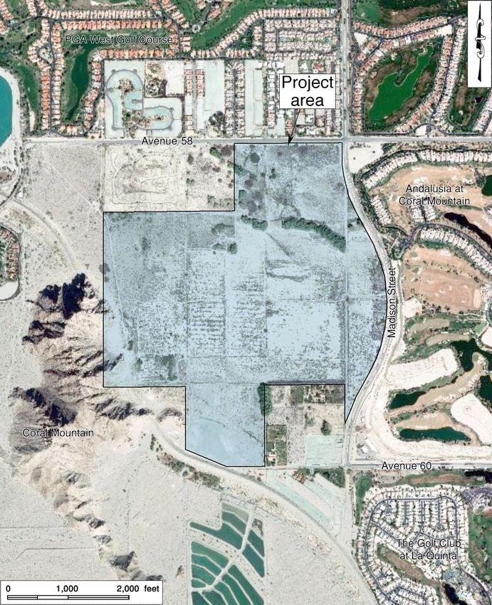
HISTORICAL/ARCHAEOLOGICAL RESOURCES SURVEY REPORT

     CORAL MOUNTAIN SPECIFIC PLAN
                       City of La Quinta
                  Riverside County, California

                        For Submittal to:

     Department of Design and Development, Planning Division
                        City of La Quinta
                      78-495 Calle Tempico
                      La Quinta, CA 92253

                         Prepared for:

                  CM Wave Development, LLC
                  2440 Junction Place, Suite 200
                       Boulder, CO 80301

                          Prepared by:

                          CRM TECH
                1016 East Cooley Drive, Suite A/B
                       Colton, CA 92324

              Bai “Tom” Tang, Principal Investigator
              Michael Hogan, Principal Investigator

                      October 31, 2019
                    (Revised May 6, 2020)
                 CRM TECH Contract No. 3511A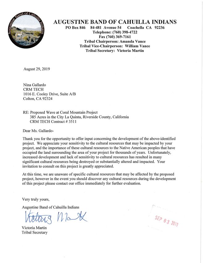
Title: Historical/Archaeological Resources Survey Report: Coral Mountain
                    Specific Plan, City of La Quinta, Riverside County, California

        Author(s): Bai “Tom” Tang, Principal Investigator/Historian
                   Deirdre Encarnación, Archaeologist/Report Writer
                   Daniel Ballester, Archaeologist/Field Director
                   Nina Gallardo, Archaeologist/Native American Liaison

  Consulting Firm: CRM TECH
                   1016 East Cooley Drive, Suite A/B
                   Colton, CA 92324
                   (909) 824-6400

             Date: October 31, 2019; revised May 6, 2020

  For Submittal to: Department of Design and Development, Planning Division
                    City of La Quinta
                    78-495 Calle Tempico
                    La Quinta, CA 92253
                    (760) 777-7125

     Prepared for: Garrett Simon
                   CM Wave Development, LLC
                   2440 Junction Place, Suite 200
                   Boulder, CO 80301
                   (970) 596-6642

USGS Quadrangle: Indio, La Quinta, Martinez Mtn., and Valerie, Calif., 7.5’ quadrangles
                 (Sections 27 and 28, T6S R7E, San Bernardino Baseline and Meridian)

      Project Size: Approximately 385 acres

        Keywords: Coachella Valley, Colorado Desert region; Phase I historical/
                  archaeological resources survey; Sites 33-000193, 33-001715 to 33-
                  001717, 33-005213, 33-005214, 33-008386, 33-008388, 33-009545, 33-
                  011625, 33-028909; Isolates 33-009000 to 33-009005, 33-028907, 33-
                  028908, and 33-028910 to 33-028912; prehistoric petroglyphs, milling
                  features, surface scatters of ceramic artifacts; historic-period farmstead,
                  graffiti, and refuse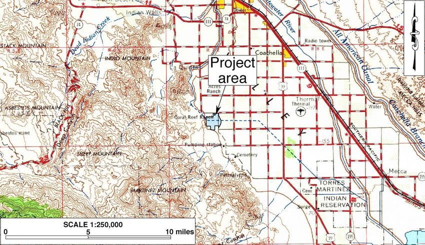
EXECUTIVE SUMMARY

Between June and October 2019, at the request of CM Wave Development, LLC, CRM TECH
performed a cultural resources study on an approximately 385-acre tract of rural land in the City of La
Quinta, Riverside County, California. The study is part of the environmental review process for the
proposed Coral Mountain Specific Plan, which proposes the development of an artificial wave facility,
a hotel, residential units, open space for golf, farm, outdoor recreational amenities, and an open-air
amphitheater as well as the eventual development of four separately planned communities. The
subject property of the study encompasses the entire area designated for the project, located on the
west side of Madison Street, between Avenue 58 and Avenue 60, within Sections 27 and 28 of T6S
R7E, San Bernardino Baseline and Meridian.

The City of La Quinta, as the lead agency for the project, required the study in compliance with the
California Environmental Quality Act (CEQA). The purpose of the study is to provide the City with
the necessary information and analysis to determine whether the proposed project would cause
substantial adverse changes to any “historical resources,” as defined by CEQA, that may exist in or
around the project area. In order to identify such resources, CRM TECH conducted a historical/
archaeological resources records search, pursued historical background research, contacted Native
American representatives, and carried out an intensive-level field survey of the entire project area.

The results of the records search indicate that 16 cultural resources were previously recorded within
or partially within the project area, including eight prehistoric sites, six prehistoric isolates, and two
historic-period sites. During the field survey, two of the prehistoric sites, one of the historic-period
sites, and four of the isolates could not be found at their recorded locations and are presumed to be no
longer extant. In the meantime, six previously unknown cultural resources were identified and
recorded in the project area, including one prehistoric site, three prehistoric isolates, and two historic-
period isolates. The eight sites and seven isolates extant within the project area today are listed below:

       Site 33-000193          rock art panels with petroglyphs and Japanese kanji
       Site 33-001715          rock art panels with petroglyphs, artifact scatter, milling features,
                               Japanese kanji, and historic-period graffiti
       Site 33-001716          ceramic sherd scatter
       Site 33-001717          ceramic sherds, flake, and sun-colored amethyst glass
       Site 33-008386          ceramic sherd scatter
       Site 33-008388          remains of Coral Reef Ranch with partially collapsed adobe house
       Site 33-009545          rock art panels
       Site 33-028909          ceramic sherd scatter
       Isolate 33-009001       one ceramic sherd
       Isolate 33-009003       one ceramic sherd
       Isolate 33-028907       one sun-colored amethyst glass shard
       Isolate 33-028908       one ceramic sherd
       Isolate 33-028910       one sun-colored amethyst glass shard
       Isolate 33-028911       two ceramic sherds
       Isolate 33-028912       one ceramic sherd

                                                    i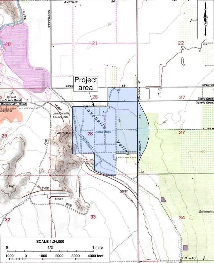
Among these, Sites 33-00193, 33-001715, and 33-009545, collectively comprising the Coral
Mountain Rock Art Complex, and Site 33-008388 appear to be eligible for listing in the California
Register of Historical Resources and thus meet the definition of “historical resources.” Under CEQA
provisions, the impact on these sites from the proposed project that would compromise their integrity
would constitute “a substantial adverse change in the significance of a historical resource” (PRC
§21084.1).

In order to prevent or mitigate potential project impact to the four sites that constitute “historical
resources,” CRM TECH recommends that Sites 33-000193 and 33-009545 and the portion of Site 33-
001715 located along the base of Coral Mountain and at the toe of the slope, which contains the rock
art panels and bedrock milling features, be avoided and protected in situ during the project through
the establishment of Environmentally Sensitive Areas. For the balance of Site 33-001715, where
scattered artifacts but no features were found, mitigative surface collection and subsurface excavation
should be completed to recover a representative sample of the cultural materials prior to the
commencement of the project. The excavation should feature a combination of standard
archaeological units, shovel test pits, and backhoe trenches to optimize both efficient coverage of the
site area and safe recovery of cultural remains, and a detailed mitigation plan should will be drafted
beforehand for review and consensus among all interested parties, including the culturally affiliated
Native American tribes.

Regarding Site 33-008388, the City of La Quinta and CM Wave Development, LLC, have reached a
preliminary agreement to preserve the primary surviving feature of the site, namely the remains of the
adobe house at Locus 1, as a future community feature with an accompanying informational plaque.
For the rest of the site, or if the preservation of Locus 1 proves to be infeasible, CRM TECH
recommends a comprehensive recordation program to reduce project impact to a level less than
significant.

None of the other sites or isolates present within the project area appears eligible for the California
Register. Therefore, they do not qualify as “historical resources” and require no further consideration
in themselves during the CEQA-compliance process. However, given the rich archaeological
discoveries in and near the project area documented in the current and previous studies, the possibility
of encountering buried prehistoric cultural remains during the project cannot be overlooked.
Therefore, CRM TECH further recommends that archaeological monitoring be implemented during
ground-disturbing activities associated with the project. The monitoring program should be
formulated and implemented in consultation with the culturally affiliated Native American tribes. If
any potentially significant cultural remains are unearthed during the project, controlled archaeological
testing excavation will be required at that location.

                                                  ii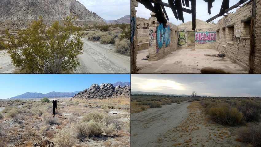
TABLE OF CONTENTS

EXECUTIVE SUMMARY ................................................................................................................... i
INTRODUCTION ................................................................................................................................ 1
SETTING .............................................................................................................................................. 4
  Current Natural Setting ..................................................................................................................... 4
  Cultural Setting ................................................................................................................................. 5
    Prehistoric Context........................................................................................................................ 5
    Ethnohistoric Context ................................................................................................................... 6
    Historic Context ............................................................................................................................ 7
RESEARCH METHODS ..................................................................................................................... 8
  Records Search.................................................................................................................................. 8
  Historical Research ........................................................................................................................... 8
  Native American Participation .......................................................................................................... 9
  Field Survey ...................................................................................................................................... 9
RESULTS AND FINDINGS ................................................................................................................ 9
  Previous Studies in the Vicinity ........................................................................................................ 9
  Historical Overview ........................................................................................................................ 11
  Native American Input .................................................................................................................... 13
  Potential Historical Resources in the Project Area ......................................................................... 14
    Coral Mountain Rock Art Complex............................................................................................ 14
    Ceramic Sherd Scatters ............................................................................................................... 17
    Historic-period Site ..................................................................................................................... 18
    Prehistoric Isolates ...................................................................................................................... 18
    Newly Recorded Site and Isolates .............................................................................................. 18
    Previously Recorded Sites and Isolates Not Re-located ............................................................. 19
DISCUSSION ..................................................................................................................................... 20
  Applicable Statutory and Regulatory Guidelines ........................................................................... 20
  Resource Evaluation ....................................................................................................................... 20
    Coral Mountain Rock Art Complex (33-000193, 33-001715, and 33-009545) ......................... 20
    Ceramic Sherd Scatters (33-001716, 33-001717, 33-008386, and 33-028909) ......................... 21
    Historic-period Site (33-008388) ................................................................................................ 21
    Isolates (33-009001, 33-009003, 33-028907, 33-028908, and 33-028910 to 33-028912) ......... 22
CONCLUSION AND RECOMMENDATIONS ............................................................................... 22
REFERENCES ................................................................................................................................... 24
APPENDIX 1: Personnel Qualifications ............................................................................................ 27
APPENDIX 2: Correspondence with Native American Representatives ........................................... 34
APPENDIX 3: Cultural Resources within or Partially within the Project Area (Confidential) ......... 47
APPENDIX 4: Proposed ESA and Preservation Area (Confidential) .............................................. 169

                                                                         iii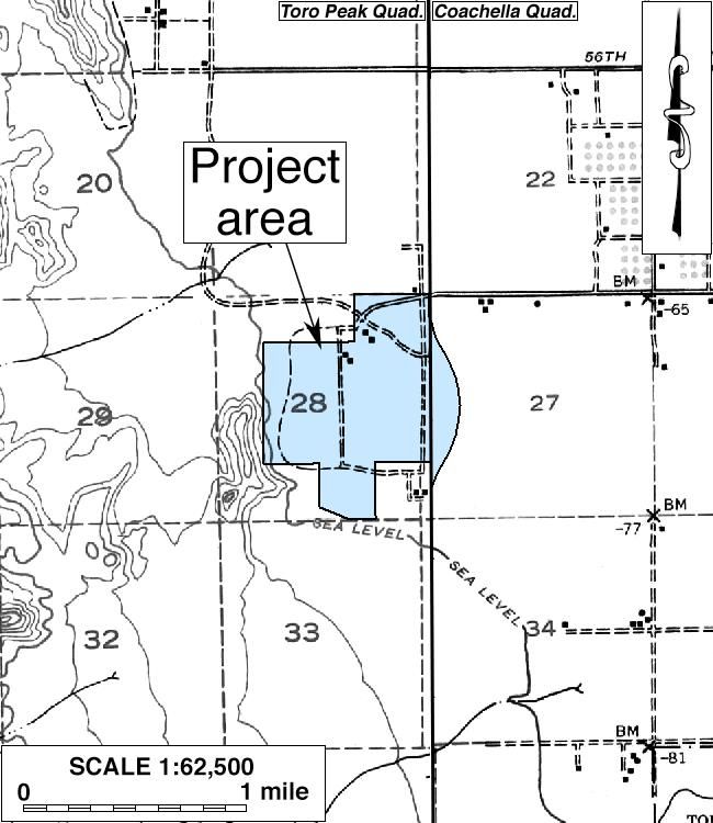
LIST OF FIGURES

Figure 1. Project vicinity...................................................................................................................... 1
Figure 2. Project area ........................................................................................................................... 2
Figure 3. Aerial view of the project area ............................................................................................. 3
Figure 4. Typical landscapes in the project area .................................................................................. 4
Figure 5. The project area and vicinity in 1855-1856 ........................................................................ 11
Figure 6. The project area and vicinity in 1901 ................................................................................. 12
Figure 7. The project area and vicinity in 1903 ................................................................................. 12
Figure 8. The project area and vicinity in 1941 ................................................................................. 12
Figure 9. The project area and vicinity in 1952-1959 ........................................................................ 12
Figure 10. Prehistoric and historic cultural remains in the project area ............................................ 15

                                                                        iv
INTRODUCTION
Between June and October 2019, at the request of CM Wave Development, LLC, CRM TECH
performed a cultural resources study on an approximately 385-acre tract of rural land in the City of
La Quinta, Riverside County, California (Fig. 1). The study is part of the environmental review
process for the proposed Coral Mountain Specific Plan, which proposes the development of an
artificial wave facility, a hotel, residential units, open space for golf, farm, outdoor recreational
amenities, and an open-air amphitheater as well as the eventual development of four separately
planned communities. The subject property of the study encompasses the entire area designated for
the project, located on the west side of Madison Street, between Avenue 58 and Avenue 60, within
Sections 27 and 28 of T6S R7E, San Bernardino Baseline and Meridian (Figs. 2, 3).
The City of La Quinta, as the lead agency for the project, required the study in compliance with the
California Environmental Quality Act (CEQA; PRC §21000, et seq.). The purpose of the study is to
provide the City with the necessary information and analysis to determine whether the proposed
project would cause substantial adverse changes to any “historical resources,” as defined by CEQA,
that may exist in or around the project area.
In order to identify such resources, CRM TECH conducted a historical/archaeological resources
records search, pursued historical background research, contacted Native American representatives,
and carried out an intensive-level field survey of the entire project area. The following report is a
complete account of the methods, results, and final conclusion of the study. Personnel who
participated in the study are named in the appropriate sections below, and their qualifications are
provided in Appendix 1.
Figure 1. Project vicinity. (Based on USGS Santa Ana, Calif., 30’x60’ quadrangle [USGS 1959a])
1Figure 2. Project area. (Based on USGS Indio, La Quinta, Martinez Mtn., and Valerie, Calif., 7.5’ quadrangles [USGS
1972a; 1972b; 1980; 1996])
2Figure 3. Aerial view of the project area.
3SETTING
CURRENT NATURAL SETTING
The City of La Quinta is situated in the Coachella Valley, a northwest-southeast trending desert
valley that constitutes the western end of the Colorado Desert. Dictated by this geographic setting,
the climate and environment of the region are typical of southern California’s desert country, marked
by extremes in temperature and aridity. Temperatures in the region reach over 120 degrees in
summer, and dip to freezing in winter. Average annual precipitation is less than five inches, and the
average annual evaporation rate exceeds three feet.
The project area is located on the southcentral outskirts of the City of La Quinta and in the eastern
foothills of the Santa Rosa Mountains, and includes a portion of a rocky knoll known as Coral
Mountain. The surrounding land uses feature primarily existing residential development associated
with golf courses to the north and the east and vacant land to the south and the west. Much of the
land within project boundaries has been farmed in the past, with the exceptions of the northeastern
corner, the southernmost portion, and the far western edge near Coral Mountain (Figs. 3, 4).
A partially collapsed adobe house (Fig. 4) is located near the center of the project area, along with
concrete pads and footings left by demolished residential and agricultural buildings. Several
unpaved roads traverse throughout the project area. A large stockpile of soil sits in the southernmost
portion, apparently removed from a retention basin located to the south of the property, across an
earthen levee.
Figure 4. Typical landscapes in the project area. Clockwise from upper left: view to the west along the southern project
boundary (former shoreline of Holocene Lake Cahuilla visible on Coral Mountain); abandoned adobe residence; dirt
road across former farmland; overview to the south. (Photographs taken on August 6-9, 2019)
4The terrain in most of the project area is relatively level due to the past agricultural operations, with
the exception of the portion in and around Coral Mountain. The northeastern portion does not
appear to have been farmed but has also been cleared of vegetation. The terrain in this area is
somewhat uneven. On the western edge, the land remains in a native creosote bush scrub state. A
large amount of tufa has formed on the boulders and rocks at the base of Coral Mountain during the
various stands of ancient Lake Cahuilla.
Soils in the former agricultural fields consists of fine- to medium-grained sands mixed with silt, clay,
and freshwater shells. Beyond the agricultural fields, soils in the westernmost portion of the project
area feature fine- to coarse-grained sands with rocks, boulders, and some freshwater shells. Fine-
grained clay is exposed in some areas, especially near the former shoreline of Holocene Lake
Cahuilla. Vegetation on the property includes creosote bush, mesquite, palo verde, brittlebush,
saltbush, tumbleweed, and other small desert shrubs and grasses (Fig. 4). Introduced landscaping
trees such as tamarisk, eucalyptus, cottonwood, and palm are found near the former residences.
During the past centuries, Native lifeways in the Coachella Valley were greatly influenced by the
inundation and desiccation of Holocene Lake Cahuilla, which began to recede for the last time
around A.D. 1680. Elevations in the project area range approximately from 60 feet below mean sea
level to 50 feet above, placing it along but mostly below the highest shoreline of the lake, which ran
along today’s 42-foot contour line and is visible along the eastern side of Coral Mountain (Fig. 4).
As a result, the level valley floor in and around the project area would have provided a favorable
setting for Native American habitation during the final desiccation of Holocene Lake Cahuilla, after
the lakeshore began to recede to the east.
CULTURAL SETTING
Prehistoric Context
Numerous investigations on the history of cultural development in southern California have led
researchers to propose a number of cultural chronologies for the desert regions. A specific cultural
sequence for the Colorado Desert was offered by Schaefer (1994) on the basis of the many
archaeological studies conducted in the area. The earliest time period identified is the Paleoindian
(ca. 8,000 to 10,000-12,000 years ago), when “small, mobile bands” relying primarily on a variety of
small and large game animals as well as wild plants for subsistence populated the region (ibid.:63).
These small groups settled “on mesas and terraces overlooking larger washes” (ibid.:64). The
artifact assemblage of that period typically consists of very simple stone tools, “cleared circles, rock
rings, [and] some geoglyph types” (ibid.).
The Early Archaic Period follows and dates to ca. 8,000 to 4,000 years ago. It appears that a
decrease in population density occurred at this time and that the indigenous groups of the area relied
more on foraging than hunting. Very few archaeological remains have been identified to this time
period. The ensuing Late Archaic Period (ca. 4,000 to 1,500 years ago) is characterized by
continued low population densities and groups of “flexible” sizes that settled near available seasonal
food resources and supplemented vegetal foods with hunting of game animals. Groundstone
artifacts for food processing were prominent during this time period.
5The most recent period in Schaefer’s scheme, the Late Prehistoric, dates from ca. 1,500 years ago to
the time of the Spanish missions, and saw the continuation of the seasonal settlement pattern.
Peoples of the Late Prehistoric Period were associated with the Patayan cultural pattern and relied on
the availability of seasonal “wild plants and animal resources” (Schaefer 1994:66). It was during
this period that brown and buff ware ceramics were introduced into the region.
The shores of Holocene Lake Cahuilla, during times of its presence, attracted much settlement and
resource procurement activities. In times of the lake’s desiccation and absence, according to
Schaefer (1994:66), the Native people moved away from its receding shores towards rivers, streams,
and mountains. Numerous archaeological sites dating to the last high stand of Holocene Lake
Cahuilla, roughly between 900 and 1700 A.D., have been identified along its former shoreline.
Testing and mitigative excavations at these sites have recovered brown and buff ware ceramics, a
variety of groundstone and projectile point types, ornaments, and cremation remains.
Ethnohistoric Context
The Coachella Valley is a historical center of Native American settlement, where U.S. surveyors
noted large numbers of Indian villages and rancherías occupied by the Cahuilla people in the mid-
19th century. The origin of the name “Cahuilla” is unclear, but it may have originated from their
own word káwiya, meaning master or boss (Bean 1978). The Takic-speaking Cahuilla are generally
divided by anthropologists into three groups, according to their geographic setting: the Pass Cahuilla
of the San Gorgonio Pass-Palm Springs area, the Mountain Cahuilla of the San Jacinto and Santa
Rosa Mountains and the Cahuilla Valley, and the Desert Cahuilla of the eastern Coachella Valley.
The basic written sources on Cahuilla culture and history include Kroeber (1925), Strong (1929), and
Bean (1978), based on information provided by such Cahuilla informants as Juan Siva, Francisco
Patencio, Katherine Siva Saubel, and Mariano Saubel. The following ethnohistoric discussion is
derived primarily from these sources.
The Cahuilla did not have a single name that referred to an all-inclusive tribal affiliation. Instead,
membership was in terms of lineages or clans. Each lineage or clan belonged to one of two main
divisions of the people, known as moieties, which were named for the Wildcat, or Tuktum, and the
Coyote, or Istam. Members of clans in one moiety had to marry into clans from the other moiety.
Individual clans had villages, or central places, and territories they called their own for purposes of
hunting game and gathering raw materials for food, medicine, ritual, or tool use. They interacted
with other clans through trade, intermarriage, and ceremonies.
Cahuilla subsistence was defined by the surrounding landscape and primarily based on the hunting
and gathering of wild and cultivated foods, exploiting nearly all of the resources available in a highly
developed seasonal mobility system. They were adapted to the arid conditions of the desert floor,
the lacustral cycles of Holocene Lake Cahuilla, and the environments of the nearby mountains.
When the lake was full or nearly full, the Cahuilla would take advantage of the resources presented
by the body of fresh water, building elaborate stone fish traps. Once the lake had desiccated, they
relied on the available terrestrial resources. Walk-in wells were dug by hand to utilize groundwater.
The cooler temperatures and resources available at higher elevations in the nearby mountains were
also taken advantage of.
6The Cahuilla diet included seeds, roots, wild fruits and berries, acorns, wild onions, piñon nuts, and
mesquite and screw beans. Medicinal plants such as creosote, California sagebrush, yerba buena and
elderberry were typically cultivated near villages (Bean and Saubel 1972). Common game animals
included deer, antelope, big horn sheep, rabbits, wood rats and, when Holocene Lake Cahuilla was
present, fish and waterfowl. The Cahuilla hunted with throwing sticks, clubs, nets, traps, and snares,
as well as bows and arrow (Bean 1978; CSRI 2002). Common tools included manos and metates,
mortars and pestles, hammerstones, fire drills, awls, arrow-straighteners, and stone knives and
scrapers. These tools were made from locally sourced material as well as materials procured through
trade or travel. They also used wood, horn, and bone spoons and stirrers; baskets for winnowing,
leaching, grinding, transporting, parching, storing, and cooking; and pottery vessels for carrying
water, storage, cooking, and serving food and drink (ibid.).
As the landscape defined their subsistence practices, the tending and cultivation practices of the
Cahuilla helped shape the landscape. Biological studies have recently found evidence that the fan
palms found in the Coachella Valley and throughout the southeastern California desert
(Washingtonia filifera) may not be relics of palms from a paleo-tropical environment, but instead a
relatively recent addition brought to the area and cultivated by native populations (Anderson 2005).
Cahuilla oral tradition tells of a time before there were palms in the area, and how the people, birds,
and animals enjoyed the palm fruit once it had arrived (Bean and Saubel 1972).
The planting of palms by the Cahuilla is well-documented, as is their enhancement of palm stands
through the practice of controlled burning (Bean and Saubel 1972; Anderson 2005). Burning palm
stands would increase fruit yield dramatically by eliminating pests such as the palm borer beetle,
date scales, and spider mites (Bean and Saubel 1972). Firing palm stands prevented out-of-control
wildfires by eliminating dead undergrowth before it accumulated to dangerous levels. The Cahuilla
also burned stands of chia to produce higher yields, and deergrass to yield straighter, more abundant
stalks for basketry (Bean and Saubel 1972; Anderson 2005).
Population data prior to European contact is almost impossible to obtain, but estimates range from
3,600 to as high as 10,000 persons covering a territory of over 2,400 square miles. During the 19th
century, the Cahuilla population was decimated as a result of European diseases, most notably
smallpox, for which the Native peoples had no immunity. Today, Native Americans of Pass or
Desert Cahuilla heritage are mostly affiliated with one or more of the Indian reservations in and near
the Coachella Valley, including Torres Martinez, Augustine, Cabazon, Agua Caliente, and Morongo.
There has been a resurgence of traditional ceremonies, and the language, songs, and stories are now
being taught to the younger generations.
Historic Context
In 1823-1825, José Romero, José Maria Estudillo, and Romualdo Pacheco became the first noted
European explorers to travel through the Coachella Valley when they led a series of expeditions in
search of a route to Yuma (Johnston 1987:92-95). Due to its harsh environment, few non-Indians
ventured into the desert valley during the Mexican and early American periods, except those who
traveled along the established trails. The most important of these trails was the Cocomaricopa Trail,
an ancient Indian trading route that was “discovered” in 1862 by William David Bradshaw and
known after that as the Bradshaw Trail (Gunther 1984:71; Ross 1992:25). In much of the Coachella
7Valley, this historic wagon road traversed a similar course to that of present-day Highway 111.
During the 1860s-1870s, the Bradshaw Trail served as the main thoroughfare between coastal
southern California and the Colorado River, until the completion of the Southern Pacific Railroad in
1876-1877 brought an end to its heyday (Johnston 1987:185).
Non-Indian settlement in the Coachella Valley began in the 1870s with the establishment of
railroad stations along the Southern Pacific Railroad, and spread further in the 1880s after public
land was opened for claims under the Homestead Act, the Desert Land Act, and other federal land
laws (Laflin 1998:35-36; Robinson 1948:169-171). Farming became the dominant economic
activity in the valley thanks to the development of underground water sources, often in the form of
artesian wells. Around the turn of the century, the date palm was introduced into the Coachella
Valley, and by the late 1910s dates were the main agricultural crop and the tree an iconic image
celebrating the region as the “Arabia of America” (Shields Date Gardens 1957). Then, starting in
the 1920s, a new industry featuring equestrian camps, resorts, hotels, and eventually country clubs
began to spread throughout the Coachella Valley, transforming it into southern California’s
premier winter retreat.
In today’s City of La Quinta, the earliest settlement and land development activities did not occur
until the turn of the century (BLM n.d.). In 1926, with the construction of the La Quinta Hotel, the
development of La Quinta took on the character of a winter resort, typical of the desert communities
along Highway 111. Beginning in the early 1930s, the subdivision of the La Quinta Cove area and
the marketing of “weekend homes” further emphasized this new direction of development (City of
La Quinta 1997:43). On May 1, 1982, La Quinta was incorporated as the 19th city in Riverside
County.
RESEARCH METHODS
RECORDS SEARCH
CRM TECH archaeologist Nina Gallardo completed the records search at the Eastern Information
Center (EIC), University of California, Riverside, on July 11 and 15, 2019. During the records
search, Gallardo examined maps and records on file at the EIC for previously identified cultural
resources and existing cultural resources reports within a one-mile radius of the project area.
Previously identified cultural resources include properties designated as California Historical
Landmarks, Points of Historical Interest, or Riverside County Landmarks, as well as those listed in
the National Register of Historic Places, the California Register of Historical Resources, or the
California Historical Resources Inventory.
HISTORICAL RESEARCH
Historical background research for this study was conducted by CRM TECH principal investigator/
historian Bai “Tom” Tang. Sources consulted during the research included published literature in
local and regional history, the U.S. General Land Office (GLO) land survey plat maps dated 1856
and 1903, U.S. Geological Survey (USGS) topographic maps dated 1904-1996, and aerial
photographs taken in 1939-2018. The historic maps are collected at the Science Library of the
8University of California, Riverside, and the California Desert District of the U.S. Bureau of Land
Management, located in Moreno Valley. The aerial photographs are available from the Engineering
Department of the Coachella Valley Water District, the Nationwide Environmental Title Research
(NETR) Online website, and the Google Earth software.
NATIVE AMERICAN PARTICIPATION
On July 2, 2019, CRM TECH submitted a written request to the State of California’s Native
American Heritage Commission (NAHC) for a records search in the commission’s Sacred Lands
File. In the meantime, CRM TECH notified the nearby Torres Martinez Desert Cahuilla Indians of
the upcoming archaeological fieldwork and invited tribal participation. Following the NAHC’s
recommendations and previously established consultation protocol, CRM TECH further contacted a
total of 11 Native American representatives in the region in writing on July 26 for additional
information on potential Native American cultural resources in the project vicinity. Correspondence
between CRM TECH and the Native American representatives is summarized below, and a complete
record is attached to this report in Appendix 2.
FIELD SURVEY
On August 6-9, 2019, CRM TECH field director Daniel Ballester and project archaeologists Sal
Boites, Sabrina Fajardo, Nina Gallardo, Ben Kerridge, Hunter O’Donnell, Michael Richards, and
Damien Tietjen carried out the intensive-level field survey of the project area with the assistance of
Native American monitor Daniel Mirelez from the Torres Martinez Desert Cahuilla Indians. The
survey was completed on foot by walking a series of parallel transects oriented north-south or east-
west and spaced 15 meters (approximately 50 feet) apart. In this way, the ground surface in the
entire project area was systematically and carefully examined for any evidence of human activities
dating to the prehistoric or historic period (i.e., 50 years ago or older). Ground visibility ranged
from poor (5-10%) in areas of dense vegetation, such as in the northeast corner of the property, to
excellent (90%) in most of the other areas.
Artifacts and features that were identified during the survey, including those previously recorded,
were marked with survey flags. Further inspection and recordation of the sites and isolates—i.e.,
localities with fewer than three artifacts—was completed upon completion of the survey. A
subsequent site visit and further field recordation was carried out on October 8, 2019, by Ballester
and project archaeologist Deirdre Encarnación. The recordation procedures included, at minimum, a
description of the resource and its components, a location map, and a sketch map for the sites. The
field maps and descriptions were then compiled into standard site record forms and submitted to the
EIC for inclusion in the California Historical Resources Inventory.
RESULTS AND FINDINGS
PREVIOUS STUDIES IN THE VICINITY
According to EIC records, as many as 11 previous cultural resource studies have involved at least a
portion of the current project area, including four large-scale overview studies and seven area-
specific studies. Three of the overview studies were conducted for the City of La Quinta General
9Plan in 1991-1992 and two updates to it in 2000 and 2010, and the other was a 2006 update to the
citywide historic resources survey. Each of these four studies covered the entire La Quinta city
limits, well beyond the current project boundaries.
Among the seven area-specific studies, four were Phase I surveys or archaeological monitoring
programs that only covered small portions of the project area along the eastern edge. The other
three, completed in 1979, 1987, and 1998, included all or most of the project area (Scientific
Resource Surveys, Inc. 1979; Gallegos et al. 1987; Love et al. 1998). However, these three studies
are now more than 20 years old and are considered out-of-date for statutory compliance purposes
today, thus necessitating the current study.
Within the one-mile scope of the records search, EIC records show nearly 60 additional studies on
various tracts of land and linear features, reflecting the rapid growth of the project vicinity over the
past 40 years. Collectively, these studies covered more than 90% of the land within the scope of the
records search and resulted in the identification and recordation of 70 historical/archaeological sites
and 49 isolates within the one-mile radius. Among these, eight of the sites and one of the isolates
dated to the historic period, representing mostly residential buildings and ranch/farm complexes but
also including a date palm garden, a well, and refuse items.
The vast majority of the previously recorded cultural resources, accounting for 62 sites and 48
isolates, were of prehistoric—i.e., Native American—origin, which attests to the rich archaeological
heritage of the La Quinta area from the prehistoric era. The sites consisted mainly of ceramic and
lithic scatters with some bedrock milling features, groundstone artifacts, and the remnants of fire
hearths. Some of the larger concentrations of artifacts have been interpreted as habitation or fish
camp sites, especially an immense, 40-acre habitation area recorded at 33-005212. A few of the
sites also yielded more significant or distinctive findings, including human cremation remains, rock
art panels, and unique artefacts such as processed clay and a stone ball. A total of 43 prehistoric
isolates consisted of pottery sherds, while three manos, one Anadonta fragment and one Olivella
bead fragment were also recorded.
Based on existing records, ten of the sites and six of the isolates were recorded within or partially
within the current project area, as listed below:
Site 33-000193 rock art panels
Site 33-001715 rock art panels with artifact scatter and historic-period graffiti
Site 33-001716 ceramic sherd scatter
Site 33-001717 ceramic sherds, flake, sun-colored amethyst glass
Site 33-005213 ceramic sherd scatter
Site 33-005214 ceramic sherd scatter
Site 33-008386 ceramic sherd scatter
Site 33-008388 historic-period farm complex with partially collapsed adobe house
Site 33-009545 rock art panels
Site 33-011625 abandoned single-family residence
Isolate 33-009000 two ceramic sherds
Isolate 33-009001 one ceramic sherd
Isolate 33-009002 one ceramic sherd
10Isolate 33-009003 one ceramic sherd
Isolate 33-009004 one ceramic sherd
Isolate 33-009005 one ceramic sherd
As recorded previously, eight of sites and all of the isolates were entirely or primarily prehistoric in
origin, and the other two sites dated to the historic period. The recorded locations of these sites and
isolates were re-visited during the field survey, including the portions of the sites that ultimately
proved to be outside project boundaries, and the pertinent field observations are discussed in the
sections below.
HISTORICAL OVERVIEW
Historical sources consulted for this study yielded no evidence of any settlement or development
activities within the project area prior to the 1910s. Between 1855 and 1903, the only man-made
feature known to be extant in the project vicinity was a “Road from Indian Wells to Torres,” a part
of the historic Cocomaricopa-Bradshaw Trail, which ran roughly 1,000 feet to the east of the project
location (Figs. 5-7). By the late 1930s and early 1940s, the segment of Cocomaricopa-Bradshaw
Trail near the project location had been abandoned in favor of a regular grid of new roads, including
the forerunners of today’s Avenue 58 and Madison Street, and had disappeared from the landscape
as a result of agricultural development in the vicinity during the early 20th century (Fig. 8; CVWD
1939).
Meanwhile, most of the project area had been
developed by that time into an agricultural
enterprise known in the 1950s as the Coral Reef
Ranch (Fig. 1; CVWD 1939). Past studies in
the project area suggest that the ranch was
established by Hartman P. Travis, a Los
Angeles physician, and his associate Lawton
Clary, who managed the property in Travis’
absence, on 320 acres of land that Travis had
acquired from the U.S. government in 1918
through a desert land claim (Love et al.
1998:44; BLM n.d.). In 1941, at least four
buildings were present on the landholdings of
the ranch, all clustered on the northern edge of
the project area (Fig. 8). The remains of the
ranch complex, including the partially collapsed
adobe house, have been recorded into the
California Historical Resources Inventory as
Site 33-008388 (Love et al. 1998:41-44;
Norwood 1998).
In 1953-1954, another residence was built on
Figure 5. The project area and vicinity in 1855-1856.
the eastern edge of the project area (Fig. 9; (Source: GLO 1856)
Woodard 2002). Located on the east side of the
11Figure 6. The project area and vicinity in 1901. (Source: Figure 7. The project area and vicinity in 1903. (Source:
USGS 1904) GLO 1903)
Figure 8. The project area and vicinity in 1941. (Source: Figure 9. The project area and vicinity in 1952-1959.
USGS 1941a; 1941b) (Source: USGS 1956; 1959b)
12original alignment of Madison Street, this house has been recorded as Site 33-011625 (ibid.). On the
Coral Reef Ranch to the west, some of the buildings present in 1941 had been removed by the 1950s,
but the farming operations continued well into the late 20th century before finally being abandoned
by the 1990s (Fig. 9; NETR Online 1953-1996; Love et al. 1998:3). Since then, the entire project
area has stood undeveloped to the present time (NETR Online 1996-2016; Google Earth 1996-2018).
The only notable change to the landscape in the project area over the past 20 years was the
realignment of Madison Street to its current route along the eastern project boundary in 2004, which
resulted in the demolition of the residence at Site 33-011625 (Google Earth 2004).
NATIVE AMERICAN INPUT
In response to CRM TECH’s inquiry, the NAHC reported in a letter dated July 23, 2019, that the
Sacred Lands File identified no Native American cultural resources within the project area but
recommended that local Native American groups be contacted for further information. For that
purpose, the NAHC provided a list of potential contacts in the region (see App. 2). Upon receiving
the NAHC’s reply, on July 26 CRM TECH sent written requests for comments to all 11 tribal
organizations on the referral list. For some of the tribes, the designated spokespersons on cultural
resources issues was contacted in lieu of the individuals on the referral list, as recommended in the
past by the tribal government staff. The 11 tribal representatives contacted are listed below:
• Patricia Garcia-Plotkin, Tribal Historic Preservation Officer, Agua Caliente Band of Cahuilla
Indians;
• Amanda Vance, Chairperson, Augustine Band of Cahuilla Mission Indians;
• Judy Stapp, Director of Cultural Affairs, Cabazon Band of Mission Indians;
• BobbyRay Esparza, Cultural Coordinator, Cahuilla Band of Indians;
• Shane Chapparosa, Chairperson, Los Coyotes Band of Cahuilla and Cupeño Indians;
• Travis Armstrong, Tribal Historic Preservation Officer, Morongo Band of Mission Indians;
• John Gomez, Jr., Cultural Resource Coordinator, Ramona Band of Cahuilla Indians;
• Mercedes Estrada, Tribal Administrative Assistant, Santa Rosa Band of Cahuilla Indians;
• Joseph Ontiveros, Tribal Historic Preservation Officer, Soboba Band of Luiseño Indians;
• Michael Mirelez, Cultural Resources Coordinator, Torres Martinez Desert Cahuilla Indians;
• Anthony Madrigal, Jr., Tribal Historic Preservation Officer, Twenty-Nine Palms Band of
Mission Indians.
As of this time, five tribal representatives have responded in writing (see App. 2). Among them,
Victoria Martin, Tribal Secretary for the Augustine Band, Nancy Markwardt, Recording
Administrator/Office Manager for the Cabazon Band, and BobbyRay Esparza of the Cahuilla Band
stated that their tribes were unaware of any cultural resources within the project area. Mr. Esparza
requested notification of future progress of the project, while Ms. Martin requested notification of
any cultural resource recovery during the project.
Lacy Padilla, Archaeologist with the Agua Caliente Tribal Historic Preservation Office, requested
copies of all cultural resource documentation for this project for tribal review as well as tribal
monitoring of all ground-disturbing activities during the project. Travis Armstrong of the Morongo
Band replied initially that the tribe had no additional information to provide at this time and would
likely defer to the Agua Caliente Band during further consultations for this project under provisions
13of Assembly Bill (AB) 52. In a later follow-up, he added that the tribe might provide other
information to the City of La Quinta during AB 52 consultations.
In addition to the written replies, Daniel Mirelez, tribal monitor for the Torres-Martinez Desert
Cahuilla Indians, provided verbal comments while participating in the archaeological field survey.
His comments were focused on the three rock art sites located within or partially within the project
area, stating that the rock art panels found at these sites should be protected during the project.
POTENTIAL HISTORICAL RESOURCES IN THE PROJECT AREA
During the field survey, it was noted that the ground surface in much of the project area has been
disturbed to various degrees, although the westernmost portion at the base of Coral Mountain
remains in a relatively natural state. Scattered modern refuse, of no historical or archaeological
interest, was observed over much of the project area, especially along the project boundaries and in
the vicinity of the adobe house at Site 33-008388, which has been heavily vandalized and appears to
serve today as a transient camp (Fig. 4).
Two of the recorded prehistoric archaeological sites and four of the isolates, namely 33-005213, 33-
005214, 33-009000, 33-009002, 33-009004, and 33-009005, all of them consisting of ceramic
sherds, could not be found at their reported locations and are presumed to have been destroyed or
removed. One of two previously recorded historic-period sites in the project area, 33-011625, is also
no longer extant, having been removed during the Madison Street realignment project in 2004, as
noted above.
In the meantime, six previously unknown historical/archaeological resources were identified and
recorded in the project area during the survey, including one prehistoric site, three prehistoric
isolates, and two historic-period isolates. These were subsequently designated by the EIC as Site 33-
028909 and Isolates 33-028907, 33-028908, and 33-028910 to 33-028912. The prehistoric site and
isolates again consist entirely of ceramic sherds, while the historic-period isolates are both single
pieces of sun-colored amethyst glass.
On balance, a total of eight sites and seven isolates are known to be present within or partially within
project boundaries today. Three of the sites contain panels of rock art as well as other associated
artifacts and features. As they are all situated in proximity to each other along the eastern base of
Coral Mountain, they have been termed the Coral Mountain Rock Art Complex. All of the sites and
isolates identified within the project area are discussed in further detail below (Fig. 10; see App. 3
for locations and record forms).
Coral Mountain Rock Art Complex
Site 33-000193 (CA-RIV-193)
Originally recorded in 1973, Site 33-000193 consists of six petroglyph panels with over 220 carved
surfaces, one bedrock metate, and a small ceramic scatter located along the base of the southeastern
most extent of Coral Mountain (Shepard 1973; McCarthy 1987; Quinn 1998a; McCarthy and
Moriquand 2003). When first recorded, the site was interpreted as “an old family or clan area,”
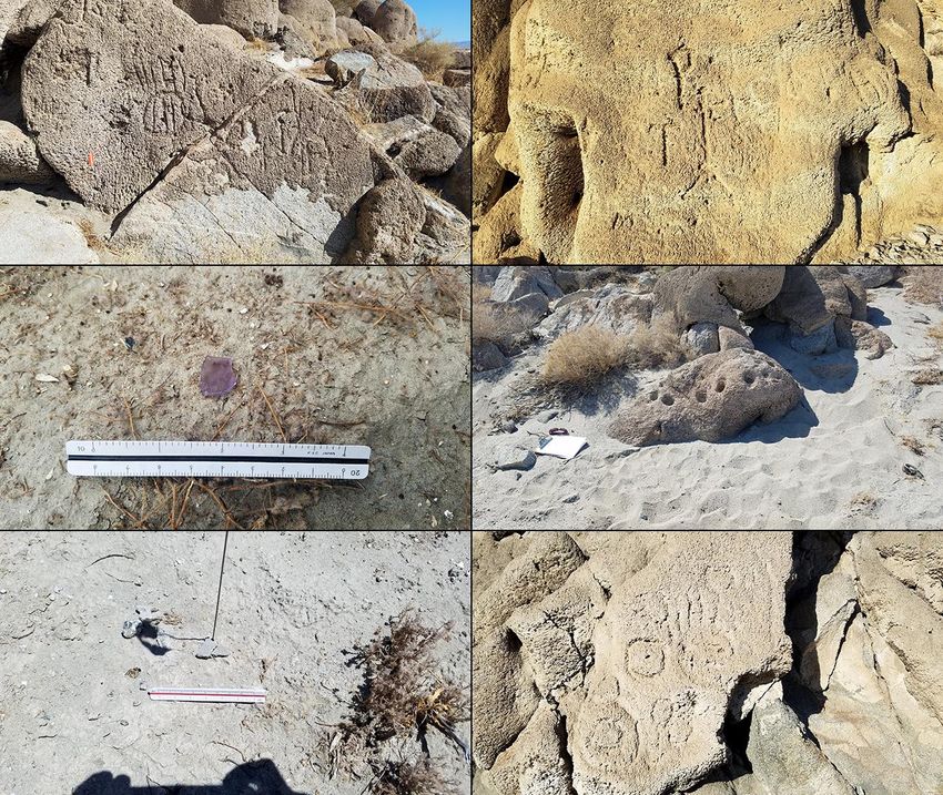
14Figure 10. Prehistoric and historic cultural remains in the project area. Clockwise from upper left: rock art panel Nos. 5
and 6 at 33-000193; petroglyphs at 33-001715; mortars in tufa-coated boulder at 33-001715; rock art panel No. 1 at
33-009545; ceramic sherds at 33-001716; sun-colored amethyst glass at 33-028907. (Photographs taken on August
6-9, 2019)
where house rings, fire pits, remains of a hand-dug well, and a cremation area were also reported,
along with a small scatter of pottery and lithic artifacts (Shepard 1973).
The petroglyph panels are pecked into tufa, and Shepard (1973) produced drawings of eight design
elements, all of which were relocated during the 1998 survey (Love et al. 1998). Panels 1 through 7
are in a small alcove. Panel 8 and 9 are located further to the north. Two of the panels have been
interpreted as containing Japanese kanji ideograms, likely carved between circa 1910 and 1927 with
a hammer and chisel (McCarthy and Moriquand 2005:49-50). One of the ideograms is eroding, but
the other has been interpreted to read “higashi” or “east” (ibid.). Records show a Higashi family as
being resident Japanese settlers in the Coachella Valley during that time period, and it is considered
coincidental that “higashi” translates as “east” and that the ideogram faces east (ibid.).
15During the current field survey, 33-000193 was revisited and its current condition noted. All of the
panels remain and the petroglyphs are clearly visible except for Panel 7, on which the petroglyph is
eroding and difficult to see. A tremendous amount of modern graffiti has been carved into the rocks
surrounding the petroglyphs, but the petroglyphs retain their original design elements and have not
been vandalized. A single buffware ceramic sherd was observed in the alcove near Panels 1-7. The
two cremations observed in 1973 were apparently removed for reburial prior to 1980 (Gallegos et al.
1987:4).
Site 33-001715 (CA-RIV-1715)
First recorded during the 1979 survey of the project area, Site 33-001715 was initially described as a
pottery sherd scatter of very light to moderate density, shown in existing site records as lying in the
same general vicinity as 33-000037 and partially overlapping the latter site (Kearns 1979a). The
rock art panels at this site were mistakenly thought to be part of 33-000037 as recorded by Safford
(1947). Site 33-000037 has since been re-located some two miles to the southwest of this location
(Quinn 1998b).
During the 1998 survey, all of the designs described by Kearns in 1979 were re-located, and several
additional designs were noted as well (Love et al. 1998). In addition to the rock art panels,
artifactual remains have been recorded on the ground surface to the east, including some 90 ceramic
sherds, four manos or mano fragments, and a metate fragment (ibid.). McCarthy and Moriquand
(2003; 2005) also described mortars, milling slicks, historic-period graffiti, and Japanese kanji
ideograms at the site.
The historic-period graffiti includes names and dates ranging from as early as “Barney 1864” to
“Lloyd Duro 1946” (McCarthy and Moriquand 2003:18). The Lloyd Duro graffiti includes a cross
motif previously thought to be of prehistoric origin. Lloyd Duro and his brother John Duro, whose
name is also carved at the site, both lived at Torres Martinez at the time (ibid.). Japanese kanji
dating to circa 1910-1927, apparently produced with hammer and chisel, have also been recorded at
the site (McCarthy and Moriquand 2005:49-50).
Site 33-001715 was revisited during the field survey, and although only Panels 1-3 of the 15
recorded panels are situated within project boundaries (see App. 3), the entire site was surveyed.
Modern graffiti is rampant throughout the site, but although much of it is in close proximity to the
petroglyphs, few of them appear to be vandalized (Fig. 10). Panel 1 consists of a handprint
exhibiting recent carving or re-carving, and may not be Native American in origin. Panel 2 is a
multi-element design consisting of a cross and three initials also exhibiting recent carving or re-
carving. Panel 3 is on the same boulder as and only a few meters northwest of Panel 2. This
element does not exhibit any recent carving and is well repatinated.
Mortars described by McCarthy and Moriquand (2003) were observed, including several on a tufa-
covered boulder located within project boundaries (Fig. 10). These mortars are unique in that they
are the only ones within the Coachella Valley known to be formed in tufa (ibid.:12). Many of the
mortars appear to be either modern or extremely altered, likely by shotgun blasts, but several are
16concluded to be of prehistoric origin. Several more mortars were noted on a ledge outside of project
boundaries, and these appear to be unaltered.
No new rock art panels were found during the current survey. More than 60 ceramic sherds were
found to the north of the panels, within the previously established site boundaries. None of the
groundstone artifacts that were observed during the 1998 survey could be found, however.
Site 33-009545 (CA-RIV-6404)
Situated roughly halfway between 33-000193 and 33-001715, Site 33-009545 was originally
recorded by McCarthy (1987) in a site record update for 33-000193 but is now considered a separate
site (Quinn 1998c). The site consists of six rock art panels carved into the tufa that covers the
granite bedrock boulders. Each of the six rock art panels were revisited during the current survey.
As with the other two sites within this rock art complex, the rock surface surrounding the
petroglyphs has been heavily vandalized with modern graffiti (Fig. 10). Panels 1 and 6 can be seen
relatively clearly in the tufa, but Panels 2, 4, and 5 exhibit a much lower visibility. The overall
condition of the six panels is deteriorating due to erosion.
Ceramic Sherd Scatters
Site 33-001716 (CA-RIV-1716)
Site 36-001716 was originally recorded as a small scatter of six sherds, possibly from a single vessel,
situated near a large mesquite stand (Kearns 1979b). Two subsequent surveys were not able to
relocate these artifacts (Gallegos et al. 1987:7; Love et al. 1998:26). During the current survey, one
ceramic sherd was observed within the previously established boundaries of 36-001716 (Fig. 10).
The small sherd was located west of a dirt road and appears to be buffware.
Site 33-001717 (CA-RIV-1717)
Also recorded by Kearns (1979c), Site 33-001717 was described as a small sherd scatter with a
possible cremation. When it was revisited in 1987, no evidence of a cremation was found, and three
sherds were collected at that time (Gallegos et al. 1987:9). The site was again visited in 1998, at
which time a total of 23 ceramic sherds, a quartz flake, and a piece of purple glass were recorded
(Love 1998a). As a result, site boundaries were expanded from 3 x 3 m to 120 x 95 m (ibid.). The
one piece of sun-colored amethyst glass dated from the early 20th century, giving the site a minor
historic component. During the current survey, 33-001717 was revisited, and the only cultural
remains observed within site boundaries were three ceramic sherds located northwest of a dirt road.
Site 33-008386 (CA-RIV-6120)
Site 33-008386 was first recorded as a light scatter of 19 ceramic sherds located south of the former
agricultural fields of the Coral Reef Ranch and north of the earthen levee (Love 1998b). The site
measured approximately 110 x 60 m in size (ibid.). The current field survey observed 10 ceramic
sherds within the site boundaries. The 10 buffware ceramic sherds are in the eastern portion of the
site, while the western portion of the site is buried beneath a large stockpile of soil.
17Historic-period Site
Site 33-008388 (CA-RIV-6122)
First recorded in 1998, Site 33-008388 represented the remains of buildings and other features of the
former Coral Reef Ranch, with a total of six loci and intermittent refuse scatters (Norwood 1998).
The most notable feature, the partially collapsed adobe house near the center of the project area, was
designated Locus 1 of the site. Historical background research on the site during the 1998 study, on
the basis of archival and oral historical sources, suggests that the house was likely built by Ben
Clary, a member of Coral Reef Ranch co-owner Lawton Clary’s family, during the 1920s or 1930s
(Love et al. 1998:44).
Among the other five loci of the site, Locus 2 was a foundation and well or cistern, Locus 3 was a
residential foundation, Locus 4 was a pole barn foundation and a well, Locus 5 was a well, cistern
and two structural foundations, and Locus 6 was a scatter of artifacts, including some that predate
1920 (Norwood 1998). The site was revisited during the current survey, and the adobe building was
found to be vandalized, burned, and further deteriorated, but the walls are standing and the adobe
bricks are overall in very good condition (Fig. 4). The rest of the site is mostly intact with the
exception of Locus 5, where only one of the two foundations, designated Feature 3 in the original
site record, still remains while the rest of the features have all been removed.
Prehistoric Isolates
Isolates 33-009001 and 33-009003
Prehistoric isolates 33-009001 and 33-009003 were both recorded in 1998 as single brownware
sherds (Love 1998c; 1998d). When these isolates were visited during the current study, the sherd at
33-009003 was re-located while an additional sherd was found at 33-009001, bringing the total
number of sherds there to two.
Newly Recorded Site and Isolates
Site 33-028909 (CA-RIV-12949)
Located in a former agricultural field in the easternmost portion of the project area, Site 33-028909
is a small ceramic scatter with six buffware sherds. The site measures approximately 30 x 14 m and
has been highly disturbed by past agricultural activities.
Isolate 33-028907
This isolate consists of a sun-colored amethyst glass shard measuring 4.4 x 4.4 x 0.3 cm (Fig. 10),
found in a former agricultural field in the northeastern portion of the project area.
Isolate 33-028908
Located in a former agricultural field in the northeastern portion of the project area, 33-028908
consists of a buffware ceramic sherd measuring 1.5 x 1.3 x 0.3 cm in size.
18You can also read