West Devon Borough Council East of Okehampton Masterplan Draft Supplementary Planning Document September 2013 - Committee version
←
→
Page content transcription
If your browser does not render page correctly, please read the page content below
0

    West Devon
    Borough Council

    East of Okehampton
    Masterplan

    Draft Supplementary
    Planning Document
    September 2013 –
    Committee version
This document can be made available in large print,
           Braille or tape format on request.

Committee version September 2013

Produced by the Strategic Planning Team
West Devon Borough Council
Kilworthy Park
Tavistock
PL19 0BZ

Email: strategic.planning@westdevon.gov.uk
Telephone: 01822 813600

© West Devon Borough Council

      East of Okehampton Masterplan – September 2013 Committee Version 2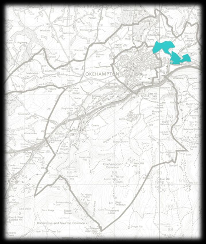
Contents

1. Introduction                                                             Page 5
   a. What is a masterplan?
   b. Why are we preparing a masterplan for new development in
      Okehampton?
   c. What will this masterplan look at?
   d. How have we prepared the masterplan?
   e. What is the status of the masterplan and how should it be used?

2. Masterplan background                                                    Page 9
   a. About Okehampton and the Hamlets
   b. Planning policy context
   c. Environmental designations

3. Priorities for new development                                           Page 13
   a. Community engagement
   b. Local council engagement
   c. Infrastructure provider engagement

4. The allocations                                                          Page 18
     Parcel 1: Opportunity Okehampton
     Parcel 2: North of Crediton Road
     Parcel 3: South of Crediton Road
     Parcel 4: East of Stockley Valley
     Parcel 5: North of Stockley Hamlet

5. Design principles                                                        Page 45
  a. Access and street layout
     - Vehicle
     - footpaths and cycleways
  b. Biodiversity
  c. Boundaries
  d. Broadband connections
  e. Building materials and style
  f. Character areas and development densities
  g. Open space provision
  h. Orientation
  i. Parking
  j. Properties and their usability
  k. Public transport
  l. Site entrances
  m. Sustainable energy
  n. Sustainable Urban Drainage
  o. Street furniture

       East of Okehampton Masterplan – September 2013 Committee Version 3
6. Delivering the development                                              Page 64

7. Glossary                                                                Page 69

8. Next steps                                                              Page 70

      East of Okehampton Masterplan – September 2013 Committee Version 4
1 | Introduction
a. What is a masterplan?
The purpose of a masterplan is to provide guidance on proposals for development. They
are usually used in relation to large or strategic sites where there is a need to establish the
overall context in which a development should be delivered. Masterplans can consider a
range of topics including the design of buildings, the layout of development, the types of
uses to be provided, the infrastructure requirements and the timescales for delivering the
development.
b. Why are we preparing a masterplan?
The Council adopted its Core Strategy in 2011. The Core Strategy is a plan which sets out
where and how development will take place in West Devon between 2011 and 2026. As
part of the Core Strategy, two areas of land to the east of Okehampton, situated within the
parish of Okehampton Hamlets, were allocated for development. For ease of reference,
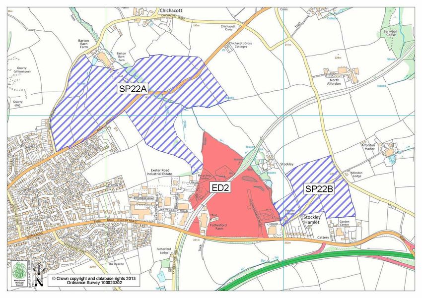
these are described in the Core Strategy as SP22A and SP22B and are shown on the map
below. The two allocations sit either side of another existing allocation (ED2) which was
designated for employment development in the 2005 saved Local Plan policies. This area
of land remains largely undeveloped, except for the Okehampton Business Centre. An
effective development of this site is equally important as the development of SP22A and
SP22B and therefore, for the purposes of this masterplan, all three sites will be considered.
East of Okehampton Masterplan – September 2013 Committee Version 5
Along with housing land, the allocation includes provision for other uses, including
employment, community facilities, a road linking Exeter and Crediton Roads, a primary
school, some small neighbourhood retailing and public open space. The development is
also linked to the provision of a town centre relief road as part of the wider strategy of growth
to be accommodated in the town. The specific requirements of the allocation are set out in
Chapter 4.
The Core Strategy explains that more detailed guidance around the design and
implementation of the allocation will be set out in a ‘comprehensive masterplan’. This
document forms the masterplan and provides the necessary guidance.
c. What will the masterplan look at?
The overall aim of this masterplan is to set the context in which any applications for
development across the sites SP22A, SP22B and ED2 will be considered. The specific
objectives of the masterplan are to:
- Provide detail to Strategic Policy 22 of the Core Strategy and ED2 of the saved Local
Plan which sets out the key requirements of the development;
- Set a vision for the new development which reflects the aspirations of the local
community;
- Create a set of overarching design principles to achieve a high quality, locally
distinctive and well-integrated development for Okehampton and the Hamlets;
- Determine the main features of the development, including the major land uses to be
accommodated, the associated infrastructure requirements and the phasing of
development alongside infrastructure;
- Put in place a framework to ensure a consistent approach to design and development
across all aspects of the allocation.
This masterplan establishes the context for development through the following sections:
The allocations: Sets out the main types of development to be included within the
allocation and guidance about how they should be distributed across the site.
Design principles: Sets out key design principles to guide the development of the site.
This framework includes information about highway, footpath and cycle links, building
materials, development layout and landscape features. It also sets out good practice
guidance for energy efficient design, sustainable construction and opportunities for
low carbon and renewable energy.
Delivering the development: Sets out how the different elements of the sites will link
together and the broad timescales for delivery.
These sections are designed to set clear principles for how the Council expects the sites to
be brought forward and to ensure that the development is comprehensively planned across
the whole site. They each contribute to the achievement of sustainable growth and should
be considered collectively as part of any application for development within the allocations.
East of Okehampton Masterplan – September 2013 Committee Version 6
Should more than one developer secure an option on land within the allocated sites, it will be
vital that each application does not compromise the delivery of the vision, principles of
development and infrastructure requirements for the sites.
The masterplan does not set a rigid and prescriptive ‘blueprint’ for development and design.
Chapter
This 2 – important
is particularly Background given the current market conditions and the cost of
Description of Okehampton
infrastructure requirements associated with the allocation. It is therefore proposed that this
Planning
masterplan Policy
will set Background
the key principles for the design and use of the site whilst allowing
sufficient flexibility to enable the development to respond to other factors, such as changes in
housing demand, affordability of homes, building costs and infrastructure requirements etc.
d. What is the status of this masterplan and how should it be used?
This masterplan is being prepared as a ‘Supplementary Planning Document’.
Supplementary Planning Documents (SPDs) have a high level of ‘weight’ in the decision-
making process as they must be prepared in accordance with national planning policies and
have to go through a statutory consultation process. Once this SPD has been adopted by
the Council, it will be used as a material consideration in determining applications for new
development in the east of Okehampton.
The preparation of the masterplan has been informed by consultation with the Okehampton
Hamlets and Town Councils, elected Members of West Devon Borough Council and the
Okehampton Vision Steering Group, thereby adding weight to the status of the document.
Full weight will be given following formal consultation and adoption. Further information is
contained in Chapter 3.
This masterplan has been prepared taking into account the following:
The East of Okehampton Design Brief: this Design Brief has been prepared by
specialist design consultants. The community was invited to be involved in this work
and has helped to shape its content. The Design Brief does not set any policies but is
being used as part of the evidence base supporting this SPD. It is available on the
Council’s website at www.westdevon.gov.uk.
Existing evidence:
Okehampton Hamlets Parish Plan: This was published in 2012 and provides a ‘snap-
shot’ of the Parish and the numerous hamlets within the area as well as an action
plan. One of the priorities identified seeks to ensure that the Parish Council are
involved in development issues, particularly on large sites.
Okehampton Town Design Statement: The Town Design Statement was published in
2004 by the Okehampton Town Design Group. It provides a helpful analysis of the
character of the town, including part of the Hamlets, with the aim of having a positive
influence on future development by encouraging carefully considered and sympathetic
development.
East of Okehampton Masterplan – September 2013 Committee Version 7
Until this SPD is adopted, it will be used as emerging policy guidance to assist the Council in
making decisions on proposals for new development on either ED2, SP22A or SP22B that
may be submitted during this time. Any applicants wishing to submit an application during
this time should be mindful of the guidance set out in this masterplan.

This SPD is consistent with the National Planning Policy Framework (NPPF) and any
applications will be considered alongside this as well as West Devon’s Core Strategy
Strategic Policy 22 and Local Plan Policy ED2.

Any developer wishing to submit an application for development on the allocated sites within
Okehampton are encouraged to commence early pre-application discussions with the
Council. Information on the pre-application service offered by the Council can be found on
the website www.westdevon.gov.uk.

    f. How can you comment on this masterplan?

    [insert consultation arrangements including exhibition date/time/venue and
    drop in surgeries to be held at Okehampton Customer Service Centre]

The purpose of this consultation is to provide more detail to Core Strategy Strategic Policy
22. It is not about whether you support the principle of development which is established
through the Core Strategy.

We would like your comments on whether you think the uses proposed are suitable, whether
you agree with our design aspirations and whether you think the infrastructure has been
planned for appropriately.

        East of Okehampton Masterplan – September 2013 Committee Version 8
2 | Masterplan background

a.    About Okehampton and the Hamlets

2.1 Okehampton is the second largest market town in West Devon. Situated in the north of
    the Borough, the town is home to around 7,500 people (Patient and Practitioner
    Services Agency 2012)1 as well as being an important service centre for many of its
    surrounding rural communities.

2.2 Lying on the northern boundary of Dartmoor National Park, Okehampton is an important
    gateway to the moor and the town’s setting is heavily influenced by this green and
    expansive landscape.

2.3 The majority of the present day town centre lies between the west and east Okement
    rivers. Here, the architecture displays features of Georgian, Edwardian and Victorian
    eras, creating an attractive and interesting historic core. Over the last century, the town
    has grown around this centre, with more recent development being focused to the east
    where there have been more opportunities for homes to be built in areas which are most
    suitable for development.

2.4 The different parts of the town meet at the key town centre junction of West Street,
    Market Street, Fore Street and George Street. This historic road arrangement is under
    increasing pressure as the town continues to grow, particularly as the town’s only
    primary school and three supermarkets are all accessed by this junction. Without
    intervention, development will continue to add to the traffic problems in this area and it is
    therefore critical to the future sustainable growth of the town that identified infrastructure
    requirements are delivered alongside new residential development in the town. There
    are three key elements to this, which comprise of the construction of a second primary
    school in the east of the town, a link road between Exeter and Crediton Road and the
    implementation of a town centre access road. The requirements for these and the
    mechanisms for their delivery are explained in more detail later in the masterplan.

2.5 Okehampton is very well located for easy access to the A30 strategic road network,
    connecting the town with the city of Exeter and the M5. Its location enables good
    opportunities for business and commercial development, as well as tourism, and the
    town can usefully promote itself in this way. Plans to introduce regular passenger
    services to the town’s rail network and open a new station in the east of the town will
    further boost the attractiveness of the town for visitors and inward investment.

2.6 Unfortunately, several large employers have been lost in the town over recent years as a
    result of difficulties in the wider economy. Planned new development in the town
    provides opportunities for new economic and job growth and the masterplan looks to
    facilitate this in a way that supports Okehampton in the future.

1

http://www.devon.gov.uk/index/councildemocracy/improving_our_services/facts_figures_and_statistics/factsandfigures/
thepeople/peopleestandproj/peoplepopestimates/peoplepopulationestandproestimatesokehampton.htm

          East of Okehampton Masterplan – September 2013 Committee Version 9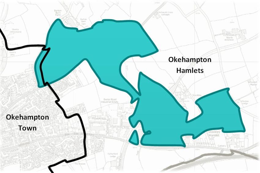
2.7 The town itself is tightly wrapped within the town council boundary, meaning that most
opportunities for new growth spread into the adjoining Okehampton Hamlets parish.
Here, the landscape reflects the more traditional agricultural practices, with small
farmsteads, rural buildings, country lanes and hamlet developments being characteristic
of the area.
2.8 This transition between urban and rural will play a key part in considering how
development is designed and located within the allocated sites. Notwithstanding the
importance of the administrative boundary, the Council considers it important to
recognise how the town and its rural fringes work together as a whole and consider
equally how new development blends with the existing built-up area and the surrounding
countryside.
b. Planning Policy Context
2.9 The strategic planning policy context in which this SPD is being prepared is provided by
the National Planning Policy Framework and the Council’s adopted Core Strategy 2011.
The relevant policies are set out below.
2.10 The National Planning Policy Framework (NPPF) 2012 sets out the framework to guide
new development in England. The framework provides relevant policies which must be
considered in the context of this SPD and any subsequent development of the allocation
to the east of Okehampton.
2.11 The key principles in relation to the development include:
A presumption in favour of sustainable development, which means positively
planning to meet the needs of the area.
Planning for a range of housing types, tenures and sizes that reflect local demands
and contributes to achieving sustainable, inclusive and mixed communities.
Promote high quality design, recognising that it is a “key aspect of sustainable
development, is indivisible from good planning, and should contribute positively to
making places better for people”.
Facilitate social interaction and support the development of places which achieve,
amongst other things, opportunities for meeting spaces, safe and accessible
environments, clear paths and cycleways and high quality public space.
Meeting the needs of retail, leisure, office and other main town centre uses and
making sure these are not compromised by limited site availability.
Having full consideration to flood risk and water supply and ensure that development
is designed and located in ways to reduce greenhouse gas emissions.
Protect, enhance and minimise impacts on valued landscapes, geology and soil
conditions, ecosystems and biodiversity.
Encourage a positive approach to the conservation and enjoyment of the historic
environment and an appreciation of the wider social, cultural, economic and
environmental benefits that can arise from the conservation of the historic
environment.
East of Okehampton Masterplan – September 2013 Committee Version 10 Ensure sufficient flexibility is included within plans and policies to respond to
changing economic circumstances and facilitate flexible working practices such as
the integration of mixed uses within the same unit.
Promote the use of sustainable transport options and the provision of viable
transport infrastructure to support sustainable development.
To encourage less use of the private car, locate new development close to key
facilities, such as schools and local shops.
2.12 Saved policy ED2 of the Local Plan sets out the requirements for the site as set out
below.
Proposal ED2
Land as shown on the Proposals Map to the north east of Fatherford Farm, to the north
west of Mole Avon and land adjacent to Exeter Road will be allocated for B1, B2 and B8
employment purposes. In considering proposals for development on this land the
Council will seek to encourage the provision for rail access.
2.13 Strategic Policy SP22 of the adopted West Devon Core Strategy 2011 sets out the key
requirements of new development on land to the east of Okehampton. This policy is
outlined below.
SP22 Okehampton
1. Land to the east of Okehampton is allocated for a mixed use development and will
include:
i. Approximately 900 dwellings, predominantly within SP22A
ii. Approximately 10 hectares of employment land, predominantly within SP22B
iii. Appropriate levels of open space
iv. Appropriate education facilities
v. Improved public transport links
vi. Provision of (or contributions to) on-site or off-site infrastructure requirements
associated with the development, including the provision of a town centre access
road.
2. The Proposals Map shows the boundaries of the strategic allocation.
3. The development of land to the east of Okehampton should be developed in
accordance with a comprehensive masterplan, along with the following site-specific
development principles:
a. Create distinctive, safe, sustainable, high quality development.
b. Integrate new development within the landscape, minimising and mitigating
landscape impacts on the natural environment.
c. The development should have regard to the close proximity of Dartmoor National
Park and mitigate for any impacts on it.
d. The development should be well integrated with new and existing services and
facilities in the town.
e. Increase travel choices for people to reduce their reliance on the private car.
East of Okehampton Masterplan – September 2013 Committee Version 11f. Provide new connections for vehicles, cycles and pedestrians between the proposed
development and the existing town to support and help ease traffic flows in the town.
g. Provide an appropriate level of affordable housing in accordance with SP9, subject to
the overall viability of the development.
h. The provision of local and strategic green infrastructure, for public sport, recreation
and play, and to include open space networks for wildlife and water management.
i. A sustainable water strategy that includes minimising use of water, recycling grey
water, has integrated sustainable drainage systems and provides flood water
retentions where appropriate.
j. The development should incorporate the latest sustainable development principles
available during the period of development and should maximise energy efficiency
and the use of energy from renewable sources.
k. The development should include the provision of neighbourhood retailing and other
facilities to meet the additional needs of the expanded community, subject to the
nature and scale of development being justified by need and there being no adverse
impact on the town centre.
l. The development should support and not prejudice the provision of a new railway
station in the east of the town and the potential to reintroduce a full rail passenger
service from Okehampton.
m. The development should support and not prejudice the delivery of a road linking
Crediton Road and Exeter Road.
c. Environmental considerations
2.14 The Core Strategy is accompanied by a Habitats Regulations Assessment (HRA)
Screening Report which assess direct and indirect impacts on internationally and
nationally designated sites. Of relevance to the development to the east of Okehampton
is the Dartmoor Special Area of Conservation (SAC). However, as no development is
proposed within the SAC, there will not be a direct effect on the integrity of the site. The
HRA notes the potential for some indirect impacts as a result of increased recreational
use of the moor, surface water run-off and traffic based pollution. However, it has been
demonstrated through the HRA that these impacts can be adequately mitigated through
other adopted planning policies and management plans.
2.15 The Council has undertaken a Screening Report of this SPD to establish whether or not
a full Sustainability Appraisal/Strategic Environmental Assessment (SA/SEA) is required.
This Screening Report concludes that a separate SA/SEA is not required as the SPD
does not result in any additional significant effects to those already identified in the
higher level SA/SEA. This Screening Report is available on the Council’s website
alongside the masterplan. Natural England will be consulted on the Screening Report
as part of the consultation process.
East of Okehampton Masterplan – September 2013 Committee Version 123 | Priorities for New Development
3.1 The development of the Okehampton allocations is needed to secure new homes and
job opportunities to support a growing community into the future. The Council
appreciates the large scale nature of the allocation and wishes to promote a
development that adds value to the town and its surrounding communities in a way that
respects the character of the area and is supported by the infrastructure and facilities
that are needed.
3.2 In preparing this masterplan, we have involved the community, local councillors and our
infrastructure partners so that we can deliver an effective and comprehensive
development of this nature.
a. Community Engagement
3.3 In terms of community engagement, local residents and businesses were invited to
attend two workshops to discuss the development of the sites as part of the preparation
of the East of Okehampton Design Brief. These workshops generated a range of ideas
and aspirations from the community and have been summarised below:
Table 1: Community aspirations for new development to the east of Okehampton
An attractive New development should:
living Be designed in a way that makes it suitable for people in all stages
environment of their lives.
Encourage sustainable and renewable energy provision using
natural assets of the town.
Integrate trees and hedgerows within well defined streets and
spaces.
Maintain a continuous network of wildlife corridors within the
development which link to the surrounding countryside.
Community New development should:
links Ensure consistent access to facilities, open spaces, the school and
the town centre through a network of footpaths and cycleway.
Provide a range of local facilities within the new development to
support basic needs whilst still promoting trips to the town centre.
Aim to keep the town and hamlets as distinct areas of Okehampton.
Encourage neighbourliness by allowing a mix of uses and facilities to
enable an active and social community.
Business New development should:
growth and job Promote the access opportunities offered by the A30.
support Integrate suitable businesses with housing to better connect home
and work life.
Make provision for small, flexible business units with space to grow.
Consider providing guest accommodation to help the local economy
take advantage of tourism opportunities.
Traffic New development should:
improvements Provide bus and rail options to reduce reliance on the private car.
Provide a network of streets capable of taking the pressure off the
East of Okehampton Masterplan – September 2013 Committee Version 13existing road network in the town, including a town centre access
road and a link between Crediton and Exeter Roads.
b. Local Council Engagement
3.4 Following on from this, the Council has worked with Okehampton Town Council,
Okehampton Hamlets Parish Council and the Okehampton Vision Steering Group to
develop these priorities into a vision for development in the town:
New development in the east of Okehampton will become a sustainable and well connected
part of this thriving and historic market town. It will create a high quality living environment
designed to support people in all ages and aspects of their lives.
This will be achieved by:
High quality well planned development that meets the day to day needs of all users
Well defined and connected streets with appropriate Attractive design which reflects the distinctive
planting and attractive, functional and accessible open characteristics of both the hamlets and the traditional
space urban centre
Properties that contain appropriate storage, private High quality design and sustainable construction methods
spaces, parking facilities and good sized gardens which use locally distinctive materials
Integrated uses of homes, workspace, community A development that becomes part of the wider
facilities, local shops and open spaces, enabling an community and continues to have the town centre as its
active, social and sustainable community focus for activities and retailing needs
Maintain the attractive environments and landscape settings of the area
Strong physical and visual connections between the Wetlands and water courses providing spaces for
different areas of land and to the surrounding recreational, ecological and sustainable drainage
countryside and Dartmoor National Park
Continuous networks of wildlife corridors within the
Sustainable and renewable energy provision in keeping development, between individual parcels and outwards
with the natural assets of the town to the surrounding countryside. Existing landscape
features including hedgerows, Devon banks, trees and
Planting of native species complementing existing the Stockley Valley should be retained.
hedgerows, Devon banks and the Stockley Valley
East of Okehampton Masterplan – September 2013 Committee Version 14Supporting job and business growth in the town
Capitalise on business opportunities by promoting the Small, flexible business units with space to grow
A30 transport links and by securing rail links in the future
Businesses based on the service and tourism sector
Provide opportunities for economic development which which make the most of the towns natural assets and
supports and enhances the existing town centre promote Okehampton as a gateway to the moor
A range of job opportunities which enable people to live and work within the town
Delivering appropriate infrastructure at the right time to support new development
A modern, fit for purpose primary school which acts as a A network of streets capable of taking pressure off
community focus in the east of the town existing roads, including a link between Exeter and
Crediton Road and the town centre relief road
Safe, secure and attractive footpaths and cycleways
connecting the development to the services and facilities Bus and rail links to reduce the reliance on the private
in the town and the surrounding countryside car
High speed broadband connections to ensure Affordable housing for local people
Okehampton is a competitive centre
Consultation question 1:
Do you agree with the vision for new development to the east of Okehampton?
c. Infrastructure Provider Engagement
3.5 Throughout the preparation of the Core Strategy, the Council worked with local service
and infrastructure providers to identify what new facilities would need to be provided and
where improvements may need to be made as a result of new development in the town.
This engagement has continued with the preparation of this Masterplan and more details
about the infrastructure that will be needed to accompany new development are set out
in this document. It is important that development on all parts of the allocation contribute
proportionally to the key elements of infrastructure required as part of the allocation
where the infrastructure concerned benefits the site as a whole.
3.6 All parts of the development will be expected to provide standard servicing and utilities
infrastructure as set out in Chapter 6. In addition to this, there are some key items of
critical infrastructure which the residential elements of the allocation will be expected to
either make provision for on-site or make financial contributions towards their delivery.
These have been identified as follows:
East of Okehampton Masterplan – September 2013 Committee Version 15Table 2: Critical infrastructure items
Infrastructure Item Description
Link road between Exeter The development is located between these two roads. It will
Road and Crediton Road be important that traffic from the new development does not
have an unacceptable impact on the town highway network,
especially if the journey is not to the town centre. A link road
will mean that traffic can avoid the Barton Road/East Street
light controlled junction. The first section of this road has
been delivered as part of the development of the H4 site.
The remainder of the road is expected to come forward as
early as possible as part of the overall scheme for the
development of the allocations.
Education provision A need for a new primary school in the town has been
Approx. 1.7 hectare site for identified to meet the needs of the existing and new
primary school within community. Land is required to be identified for this facility
SP22A as part of the masterplanning process.
Enhancements /
extensions to Primary Additional capacity will be required at Okehampton College
School provision to accommodate the additional pupils arising from the new
Enhancements / development.
extensions to Secondary
School provision
Town centre access road As a result of further development in Okehampton, there is a
requirement for a second road to access the main town
centre car park and supermarkets, enabling traffic to avoid
the main shopping areas of the town. A town centre access
road would also avoid adding to the air quality problems in
Market Street.
Primary healthcare provision Financial contributions from residential development in the
(to meet the needs of the town will be required to ensure there is sufficient capacity in
increase in local residents) primary healthcare provision to meet the needs of the new
residents.
Age appropriate equipped Appropriate play and recreation areas are required to be
play and recreation areas provided alongside new development. The Open Space,
Sport and Recreation Study commissioned by the Borough
Council in 2006, identified a need for a Neighbourhood
Equipped Play Area (NEAP) and Local Equipped Play Area
(LEAP). The location, design and layout of such facilities
should be determined through the pre-application process.
Provision of bus service to Improvements to bus services are required to provide links
serve new development between the new development and the town centre, as well
as between Okehampton and Exeter. The proposed link
road between Exeter Road and Crediton Road will help to
improve the route of bus services.
Enhancements to / additional New development in the town will generate a need for
provision of playing pitches additional provision of playing pitches. Through the
East of Okehampton Masterplan – September 2013 Committee Version 16masterplan, consideration will be given to the best way this
can be delivered to meet the needs of the town. The town
has a number of pitches. Proposals are being developed
for additional training pitches elsewhere in the town.
Depending on the capacity of existing pitch provision, it may
be appropriate to seek financial contributions towards
enhancing or increasing existing facilities.
East of Okehampton Railway There is an aspiration to deliver daily passenger services
Shelter between Okehampton and Exeter. Subject to franchise and
other agreements, this could be implemented using the
existing station in the south of the town. Should these
passenger services be delivered successfully, there is
potential to increase usage of the train by putting in place a
more accessible station for residents in the east of the town,
particularly given the large scale development which is
planned for this area. This station would benefit residents as
well as helping to attract businesses and inward investment
as part of the comprehensive development of the ED2
allocation. It is envisaged that this will take the form of a
small shelter and platform that will be accessed from the
ED2 Opportunity Okehampton site.
3.7 More details about the timescales and mechanisms for the delivery of these items of
infrastructure are provided in Chapters 4 and 6 of this Masterplan.
East of Okehampton Masterplan – September 2013 Committee Version 174 | The Allocations (Parcels 1-5)
4.1 The allocations of ED2 and SP22 cover a large area to the east of Okehampton. In order
to achieve a consistent approach to design and development across all aspects of the
allocation, it is important that the masterplan considers how the major land uses can be
distributed effectively across the area, ensure that the overall requirements of the
development are reflected across the entire site and understand and address the
cumulative impact of the development on the town’s infrastructure.
4.2 In this way, the Masterplan will put in place a framework to guide the development of the
whole allocation. However, because the allocation is dispersed across a wide area and
is segmented by a number of boundaries, including roads, valley corridors, a railway line
and existing development, it is considered necessary to look at the different parcels of
land which make up the allocation. These parcels need to be planned for individually,
as well as having regard to the overall framework in which development should be
considered.
4.3 This Chapter therefore looks at the different parcels which comprise the allocation and
sets out the site specific context in which development should be considered. Chapters
5 and 6 describe the overall design principles for new development and the Council’s
approach to managing infrastructure provision and viability considerations.
4.4 The following table and map identify five individual parcels which comprise the overall
allocation:
Table 3: Parcels of land to the east of Okehampton
Parcel Site Size (ha) Page Reference
1: Opportunity Okehampton 11.2 20
2: North of Crediton Road 14.7 23
3: South of Crediton Road 13.7 30
4: East of Stockley Valley 9.8 36
5: North of Stockley Hamlet 9.3 40
East of Okehampton Masterplan – September 2013 Committee Version 18Figure 1: Parcels of land to the east of Okehampton
East of Okehampton Masterplan – September 2013 Committee Version 19Parcel 1: Opportunity Okehampton
4.5 Parcel 1 relates to the land within ED2 to the
south of the railway line (referred to as ED2
South).
4.6 Parcel 1 is approximately 11.2 hectares in
size and is partially developed with key road
infrastructure already in place, which also
serves the existing Okehampton Business
Centre located in the south eastern corner of
the site.
4.7 A large part of the remainder of the site is
subject to a planning application that is expected to be submitted later in 2013. The
Council is working with all relevant parties to develop the application for this area.
Constraints
4.8 There are no major constraints to
development in this area.
Access
4.9 Vehicle access is already in place from
Exeter Road. No other access points are
required to facilitate the development of this
site.
Land Use
4.10 The focus of this site is to achieve a
development which supports local business growth, increases job opportunities and
promotes high quality employment uses.
4.11 In the current conditions, it is accepted that achieving more traditional employment uses
poses a significant challenge due to the costs of funding serviced land and associated
infrastructure requirements. The Council is therefore prepared to take a flexible
approach to the types of uses which come forward in Parcel 1, providing the focus is on
achieving a range of high quality employment opportunities. This is supported by the
NPPF (paragraph 22) which requires land allocations to be kept under review and where
there is no reasonable prospect of a site coming forward, to consider alternative uses.
Proposals for development that do not fall within the requirements of policy ED2 of the
Local Plan will be advertised as a departure from the adopted development plan to allow
discussion on the suitability of alternative uses through a robust decision making
process.
4.12 This area of land will be more suitable for larger businesses, particularly those that
require and/or generate significant lorry/HGV movements, as most of the supporting
infrastructure is in place and access already exists on to Exeter Road.
East of Okehampton Masterplan – September 2013 Committee Version 204.13 Proposals for other uses in addition to B1, B2
and B8 will be considered where it enables the
delivery of the rest of the site, offers high quality
employment opportunities, does not have a
significant adverse impact on the town centre
and is compatible with the surrounding
employment uses.
4.14 Any proposals for alternative uses (such as
retail, leisure, commercial and service industry
development) will need to be carefully
considered to ensure that there is no significant
adverse impact on the town centre. It is not within the remit of this masterplan to
determine whether or not such uses will be acceptable. Any proposals for such
development within this site will need to be assessed against the policies of the NPPF,
the Council’s Core Strategy and Local Plan and the adopted SPD on Assessing the
Impact of New Retail Development in West Devon.
4.15 The development of Parcel 1 should not
preclude the future delivery of a railway station
and associated parking provision for around
60-70 vehicles. It will also be vital to ensure
pedestrian and cycle connections to the
existing rail over-bridge to Hameldown Road
are provided. Connections to the overbridge
could come forward prior to the delivery of the
railway to ensure improved linkages between
the various parcels of development.
4.16 The site is located along one of the main
entrances to Okehampton. As such, a well defined and high quality frontage along
Exeter Road should be achieved where topography allows. Buildings should be of high
quality design that builds on the character of Okehampton Business Centre. In this way,
development of this parcel should reflect the principles in the Employment Character
Area set out in Chapter 5 section (f).
Infrastructure
4.17 Parcel 1 will be expected to deliver all required servicing and utilities infrastructure as set
out in Chapter 6. In addition, the provision of a railway shelter within the development
has been identified as a critical piece of infrastructure to be delivered in association with
the potential extension of passenger services. Should the site be delivered ahead of
services becoming available, sufficient space and access should be provided along with
provision for parking for approximately 60-70 vehicles, cycle parking, a bus stop and
coach parking to enable a transport interchange in the area.
Phasing
4.18 Development of this parcel is expected between 2014 and 2018.
East of Okehampton Masterplan – September 2013 Committee Version 21Indicative Layout
Figure 2: Parcel 1 indicative layout
Consultation question 2:
Do you agree with the proposals for Parcel 1 (Opportunity Okehampton)?
East of Okehampton Masterplan – September 2013 Committee Version 22Parcel 2: North of Crediton Road
4.19 Parcel 2 relates to land within SP22A north of Crediton Road and to the west of the
Stockley Valley (referred to as north of Crediton Road).
4.20 This area of land is approximately 14.7 hectares in size. It is mainly in agricultural use
for grazing and is bordered to the east by the dense woodland of the Stockley Valley.
There are a number of important hedgerows running through the site which are
important habitats for local wildlife.
Constraints
4.21 There are various constraints within Parcel 2 which will need to be taken into account
during the design and layout of new development. These are explained in the table
below and are shown on the accompanying map:
Table 4: Parcel 2 constraints
Local heritage and To the west of Parcel 2 on the boundary of Chichacott Road is a
archaeological Roman Fort, which is protected as a Scheduled Ancient Monument
assets (SAM). Some evidence of the fort is still available on the ground and
as such the visual setting of this important heritage feature will be an
important consideration in the layout of new development. Further
archaeological investigations and geophysical surveys will be required
to determine if there is a Roman Road running out of the eastern gate
of the fort. An appropriate buffer will be required to provide suitable
protection to this archaeological asset.
Stockley Valley The Environment Agency has identified a flood zone through the
Stockley Valley. This is classified as flood zone 3, which is considered
to be at high risk of flooding. As such, residential development in this
area is considered to be ‘more vulnerable’ and should not be located
here. It is therefore proposed that no development takes place within
the identified flood zones in accordance with Core Strategy Strategic
Policy 21.
The watercourse and the woodland which surrounds it are important
habitats for local biodiversity and by virtue of the flood zone, an
appropriate buffer will be in place to help conserve and enhance the
natural habitats in this area.
Woodlands, The Stockley Valley forms a dense area of woodland and runs along
hedgerows and trees the eastern boundary of Parcel 2. Lowland mixed deciduous
woodland is present here. These woodlands should be retained in
development proposals. There is also a network of locally distinctive
hedgerows present on this parcel which should be retained wherever
possible and enhanced through proposals for new development.
Visual sensitivity Parcel 2 can be viewed from the northern boundary of the Dartmoor
National Park. However, this area of land is relatively low lying and
relates both physically and visually with surrounding built up
development.
East of Okehampton Masterplan – September 2013 Committee Version 23Figure 3: Parcel 2 constraints map
Access
4.22 Suitable access to Parcel 2 can be
achieved from Crediton Road. Two
access points will be required to serve this
part of the development and to allow
movement of traffic through the site.
Specific arrangements about the location
of the access points and junction
arrangements should be discussed with
Devon County Council in the early stages
of preparing an application, giving due
consideration to existing junction
arrangements and the planned link road
between Exeter and Crediton Road.
4.23 The need for this future link road between Exeter and Crediton Road was identified in
relation to the development of site H4 in the previous Local Plan. With this development
currently under construction, the pressures on the existing road network are increasing.
4.24 It has been confirmed by Devon County Council that any further development in the east
of the town will require the completion of the link road as early in the development as
can be viably achieved. There are currently significant traffic pressures at particular
traffic junctions in the town and this masterplan identifies the requirement of this link
road as a critical item of infrastructure needed to accommodate the development.
East of Okehampton Masterplan – September 2013 Committee Version 244.25 The requirement for the link road stems
from the need to relieve traffic pressures on
the Barton Road junction and Limehayes
Road and to create more sustainable
vehicle links between the residential and
employment areas of the planned
development. This link road, together with
the delivery of the new primary education
facilities within Parcel 2, should have a
positive effect on managing some of the
traffic problems which already exist.
4.26 The first phase of this link road has been
implemented as part of the H4 development which is currently under construction. The
route of the link road should run between the H4 site and Parcel 3.
Land Use
Neighbourhood Centre
4.27 In addition to residential development, other uses that will need to be accommodated on
this site include a neighbourhood centre, a site for a new primary school and a
landscape/open space buffer to the Scheduled Ancient Monument to the north west of
the site.
4.28 The neighbourhood centre should help to form a focal point for community interaction for
new and existing residents in the east of the town. The Core Strategy makes provision
for small-scale neighbourhood retailing (e.g. a small foodstore of around 250m2 primarily
for top up shopping trips) to meet the basic shopping needs of the new community and
residents in the east of the town, providing that proposals are of an acceptable nature
and scale to the development. Any proposals for food/non-food retail units over this
threshold will need to demonstrate that they will not have a significant adverse impact on
the town centre, in accordance with local and national policy. The local threshold is set
out in the Council’s adopted Assessing the Impact of New Retail Development in West
Devon Supplementary Planning Document.
4.29 The community has expressed a desire to see a community building as part of the new
development. There is no requirement in the adopted policy to provide this facility but
the masterplan does not prevent this type of use coming forward as a community or
private enterprise. Consideration will need to be given to the funding and long-term
management and maintenance of any community facility that is brought forward.
4.30 Through previous consultation with the community, some residents have also expressed
a wish to see a public house delivered in the east of the town. The consultation
identified that many would wish to see a family friendly facility, which caters particularly
for the early evening period which is not currently offered in the town. This sort of use
would be encouraged where is does not compete with existing town centre uses.
East of Okehampton Masterplan – September 2013 Committee Version 25Education
4.31 Despite the approval for residential development on the site previously identified in the
Local Plan for a new primary school, the need still exists to identify a suitable site and
options are being explored as part of this masterplanning exercise.
4.32 At the time of writing the masterplan, Devon County Council as the Education Authority
has approved capital funding sufficient to purchase a primary school site to the east of
Okehampton. The site will meet the impact of approved development in the town (H4)
and the core strategy allocations.
4.33 The Education Authority has agreed to secure a site large enough to accommodate the
existing and planned development. The education authority has agreed to forward fund
the cost of the larger site on the basis that it will be reimbursed through developer
contributions as and when future residential development secures planning consent.
4.34 Devon County Council has identified an area of
land in the west of the allocation adjacent to
Chichacott Lane for this new primary school.
This is well located to the existing residential
properties in the east of Okehampton and the
new residential development. The County
Council requires a site that is well related to the
existing and new development and can be
directly accessed from Crediton Road.
4.35 The school itself is expected to be delivered as
early as possible once planning permission is
granted for development on parcel 2. It is a
critical piece of infrastructure and all new residential development will be required to
contribute to the delivery of the school through appropriate s106 agreements. This
includes development on allocat3ed sites as well as any other development which may
come forward in the town.
4.36 Developers are encouraged to engage with Devon County Council at an early stage to
discuss arrangements for education provision required as part of the development.
4.37 There is a forecast deficit in pupil places at Okehampton College. As such, further
places will need to be provided to accommodate the anticipated increase in secondary
school pupils from the new development. It will therefore be necessary to collect
financial contributions from the development for secondary education where a need has
been identified.
4.38 The new primary school neighbourhood centre should be well related to the
neighbourhood centre. The connectivity and location of these uses in a central position
to serve the new and existing residents will be important and will enable:
The use of shared car parking facilities
The concentration of main public transport links
East of Okehampton Masterplan – September 2013 Committee Version 26 An effective integration of footpaths, cycleways and roads around the development
towards a central location where the key services within the development are
provided.
Dual use of facilities where appropriate and achievable
Housing
4.39 Parcel 2 is allocated for predominantly residential development and is expected to
deliver approximately 350-375 homes. As with all residential developments, the Parcel
should provide 40% affordable housing in accordance with Core Strategy Strategic
Policy 9.
4.40 Given the relationship of this parcel to the existing residential development to the west
and south, it is appropriate to encourage a design character which reflects the traditional
styles and densities of the town. In this way, development of this Parcel should reflect
the principles of the Traditional Okehampton Character Area set out in section f of
Chapter 5. Smaller bedroom properties are encouraged in the form of terraced and
semi-detached properties in order to meet the identified housing needs of the
community. It may be appropriate to seek higher densities of development around the
neighbourhood centre with less dense development as you move eastwards towards the
Stockley Valley.
4.41 Given the recent welfare reforms, it is increasingly important that the development
makes suitable provision for one bedroom properties as part of the mix of homes offered
across the site, primarily as part of the affordable housing provision. Developers are
encouraged to think creatively about how such properties can be provided.
Public Open Space, Sport and Recreation
4.42 For 350-375 houses, according to policy H26 of the local plan, up to 0.32ha of play
should be required on this site. Typically this would equate to a LEAP (Local Equipped
Area for Play) in terms of its area. However, rather than provide a LEAP/LAP (Local
Areas for Play) in each of parcels 2, 3 and 4, there is more benefit to be gained for the
community to provide a NEAP (Neighbourhood Equipped Area for Play) within Parcel 2.
This would provide a larger range of play equipment, an associated grass kick about
area and hard surfaced play space.
4.43 Guidance indicates that children should have access to a NEAP within 15 minutes walk
or 1,000m (in a straight line) of their house. As such, a NEAP in Parcel 2 could provide
for all parcels (perhaps with the exception of parcel 5). Other LAP/LEAPs being
provided through the H4 site will cater for more local provision of smaller play facilities
without the need to provide through the parcels 2, 3 and 4.
4.44 As such, within Parcel 2, approximately 0.8ha is required to be set aside for the NEAP
providing the first five pieces of equipment. Parcel 2 is not expected to fully equip this
NEAP facility and contributions will be sought from later phases. Early consultation will
be required with the Council’s Natural Environment and Recreation Team to determine
the location and appropriate equipment to be provided.
East of Okehampton Masterplan – September 2013 Committee Version 274.45 There is an existing deficiency in playing pitch provision in Okehampton which has been
identified in the Council’s Open Space, Sport and Recreation Study 2007. The
development itself will also generate a need for further provision. As there is limited
space for on-site pitch provision within SP22A it is considered most appropriate for
Parcel 2 to provide a commuted sum equivalent to the provision of up to 1.3ha of playing
fields (including changing facilities) and maintenance so that suitable facilities can be
delivered elsewhere in the town.
4.46 Parcel 2 is also expected to provide 0.48ha of amenity space or a commuted sum
equivalent to such provision and maintenance.
Infrastructure
4.47 Detailed information about the infrastructure required and mechanisms for delivery is
provided in Chapter 6. Parcel 2 will be expected to provide all relevant servicing and
utilities infrastructure as listed in table 8 of Chapter 6.
4.48 There are a number of critical items of infrastructure which will need to be either
provided on-site or through financial contributions. These are required in order to make
the development acceptable. These are:
Provision of link road between Exeter and Crediton roads;
Approx. 1.7 ha site for primary education facilities and development of primary
school facility;
Contributions to primary and secondary school provision;
Primary healthcare provision;
Age appropriate equipped play and recreation areas;
Bus service provision to link the development with other parts of the town;
Enhancements/additional provision of playing pitches; and
Provision of town centre access road.
4.49 There are further items of desirable infrastructure which would have benefits for the
development and wider community and contributions to these may be sought where
funding is available and where it can be justified that the development has a direct
impact on its use.
Phasing
4.50 Development of this parcel is expected between 2014 and 2018.
East of Okehampton Masterplan – September 2013 Committee Version 28Indicative Layout
Figure 4: Parcel 2 indicative layout
Consultation question 3:
Do you agree with proposals for Parcel 2 (North of Crediton Road)?
East of Okehampton Masterplan – September 2013 Committee Version 29Parcel 3: South of Crediton Road
4.51 Parcel 3 is made up of two distinct areas of the allocation:
- Land within SP22A to the south of Crediton Road (referred to as SP22A South)
- Land within ED2 to the north of the railway line (referred to as ED2 North)
4.52 Although these two sites form separate allocations, their proximity and physical
relationship to one another means that there is an opportunity to consider their
development jointly. Combining these sites is likely to enable a more viable and
comprehensive development and encourage an effective use of ED2 North which is
subject to a range of constraints as outlined below.
4.53 Overall, Parcel 3 covers an area of approximately 13.7 hectares. SP22A South is mainly
in agricultural use for grazing and is bordered to its east by dense woodland surrounding
the Stockley Valley. A small section of ED2 North is already developed for use as a
depot.
4.54 There a number of constraints within Parcel 3 which will affect the types of land uses
considered suitable for this area and which will have implications for how the
development should be designed. These are explained in the table below and shown on
the accompanying map:
Table 5: Parcel 3 constraints
Stockley Valley The Environment Agency has identified a flood zone through the
Stockley Valley. This is classified as flood zone 3, which is
considered to be at high risk of flooding. As such, residential
development in this area is considered to be ‘more vulnerable’
and should not be located here. It is therefore proposed that no
development takes place within the identified flood zones in
accordance with Core Strategy Strategic Policy 21.
The watercourse and the woodland which surrounds it are
important habitats for local biodiversity and by virtue of the flood
zone, an appropriate buffer will be in place to help conserve and
enhance the natural habitats in this area.
Woodlands, hedgerows The Stockley Valley forms a dense area of woodland and runs
and trees along the eastern boundary of the SP22A South site. Lowland
mixed deciduous woodland is present here. These woodlands
should be retained in development proposals.
Visual sensitivity Parcel 3 can be viewed from the northern boundary of the
Dartmoor National Park. However, this area of land is relatively
low lying and relates both physically and visually with
surrounding built up development, particularly the development
of H4 which lies immediately adjacent to SP22A South.
Ground conditions A former landfill site is located within ED2 North and as such is
classified as contaminated land. Investigation work is needed in
East of Okehampton Masterplan – September 2013 Committee Version 30You can also read