Wairarapa Family walks and day visits - Wellington region - Jane
←
→
Page content transcription
If your browser does not render page correctly, please read the page content below
Wairarapa
Family walks and day visits

Wellington region

Contents
                                                        What to do in the Wairarapa                    2

                                                        Track classifications                         4

                                                        Abbreviations                                  5

                                                        Plan and prepare                               5

                                                        Walking opportunities by area                  7
                                                            Tararua Forest Park                        7
                                                            Rimutaka Forest Park                      18
                                                            Aorangi Forest Park                       24
                                                            Wairarapa Moana                           38

                                                        Wairarapa tangata whenua                      42

                                                        Activities                                    50
                                                            Hunting                                   50
                                                            Fishing                                   51
                                                            Mountain biking and cycling               52
                                                            Horse riding                              54
                                                            Four-wheel driving                        55

                                                        Bird watching and other interesting fauna     56

                                                        Botany                                        58

                                                        Accommodation                                 62
                                                            Lodges                                    62

                                                        Camping                                       64
                                                            Campsite categories                       64
                                                            Conservation campsites in the Wairarapa   65

                                                        Huts                                          67
                                                            Hut categories                            67
                                                            Backcountry hut user charges              67
                                                            Conservation Huts in the Wairarapa        68
                                                            Shelters                                  71

Cover image: Castlepoint lighthouse. Photo Joe Hansen                                                  1
What to do in the Wairarapa                                                The Wairarapa coastline extends for 220 kilometres and
                                                                           is an area of high interest to iwi. It is also an important
The Wairarapa area provides a wide range of recreation                     commercial fishery.
opportunities and plant and animal habitats to visit.                      Wairarapa Moana contains wetlands that are regionally
The area covers five ecological districts ranging from the                 and nationally important as a wader bird habitat, for sport
Tararua and Rimutaka ranges to the Wairarapa plains, and                   game shooting and are also traditional areas for food
to the hill country in the east and north of the area. Features            gathering by Māori.
of the area include the Tararua, Rimutaka and Aorangi forest               The eastern and northern area of the Wairarapa has few
parks, which are popular with trampers and other forest park               legally protected areas, and remaining forest and wetland
users. The Pukaha Mount Bruce National Wildlife Centre                     habitats contain several endangered native plant species.
supports the conservation of nationally endangered species                 The rare short-tailed bat is found in one location in the
through captive management.                                                Tararua Forest Park.

2                                       Tararua ranges. Photo Joe Hansen                                                                 3
Track classifications                                                  Tracks are measured in time and distance. Times given
                                                                       are a guide only and will vary depending on weather, track
                                                                       conditions and fitness levels of the people participating.
Short walk
    • Easy walking for up to an hour                                   Abbreviations
    • Track is well formed with an even, well drained
      surface. There may be steps                                      SH State Highway
    • Suitable for people of most ages and fitness levels              VC Visitor Centre
    • Stream and river crossings are bridged                           FP Forest Park
    • Walking shoes required                                           Public transport: The only public transport available is
                                                                       access into the Wairarapa by train or bus from Wellington.
Walking track                                                          Bird watching: All DOC-managed areas are suitable for
    • Gentle walking from a few minutes to a day                       viewing birds.
    • Track is mostly well formed, some sections                       Botany: All public conservation land is suitable for
      may be steep, rough or muddy                                     viewing plants.
    • Suitable for people with low to moderate fitness and abilities
    • Some tracks suitable for mountain biking
    • Clearly signposted. Stream and river crossings are bridged
    • Walking shoes or light tramping/hiking boots required

Easier tramping track                                                  Plan and prepare
    • Comfortable multi-day tramping/hiking                            It is important to plan and prepare your trip and be well equipped.
                                                                       Before you go, know the Outdoor Safety Code – 5 simple rules to
    • Track is generally well formed, some sections
                                                                       help you stay safe:
      may be rough, muddy or steep
                                                                       1. P
                                                                           lan your trip. Take a map/track brochure and remember to
    • Suitable for people with limited backcountry (remote area)          buy hut tickets for overnight stays.
      experience
                                                                       2. T
                                                                           ell someone responsible where you are going and estimated
    • Some tracks suitable for mountain biking                            return time.
    • Track has signs, poles or markers. Major stream and river        3. B
                                                                           e aware of the weather. Check weather forecasts before you
      crossings are bridged                                               go on 0900 999 24 or www.metservice.com
    • Light tramping/hiking boots required                             4. Know your limits.
                                                                       5. Take sufficient supplies.
Tramping track                                                         Leave your trip details with a trusted contact. For more information
    • Challenging day or multi-day tramping/hiking                     see www.adventuresmart.org.nz
    • Track is mostly unformed, may be rough and steep                 Your safety is your responsibility
    • Suitable for people with moderate to high level backcountry
      (remote areas) skills and experience, navigation and survival
      skills required
    • Some tracks suitable for mountain biking                         Alert!
    • Track has markers, poles or rock cairns. Expect unbridged        Facilities and services can change. Before you set out,
      stream and river crossings                                       check the latest track and hut information on the DOC website:
                                                                       www.doc.govt.nz/recreation
    • Tramping/hiking boots required
                                                                       For your own safety, never leave valuables on display in car.

4                                                                                                                                         5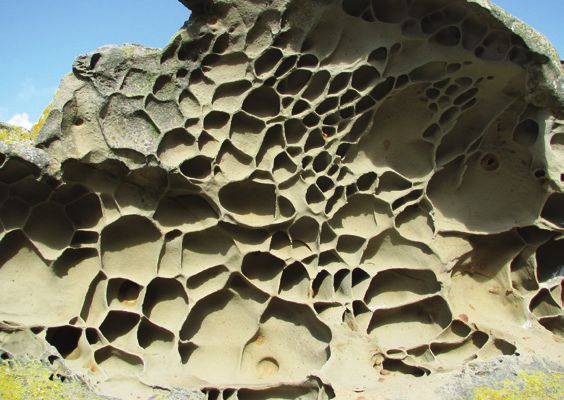
Walking opportunities by area
Tararua Forest Park
3
Established in 1954, the forest park stretches from the
Rimutaka Summit on SH2 to the PahiatuaPALMERSTON
Track in the north.
At approximately 116,535 ha it is the largest conservation
NORTH park
in the North Island. It provides visitors with opportunities
for tramping, hunting, walking and studying56plants in a wild,
1
natural landscape. Riv
er
u
at
naw 57
a
M
Backcountry hut
Backcountry hut
Booked hut / lodge
(exclusive
Booked use)
hut / lodge (exclusive use)
DOC land / access point
DOC land / access point
Track (walking, tramping, route)
Track (walking, tramping, route) Ri v
er
a
0 ok
LEVN 10
10 20
20 km
km
t ai n
a
ng
Ma
EKETAHUNA
page 16 Putara
W.A. Miller
Scenic Reserve
Waingawa River above Cow Creek. Photo: Joe Hansen
OTAKI
TARARUA Ruamahanga PUKAHA
Dog walking care code 1
MOUNT
FOREST BRUCE
When enjoying a day in the park with your dog, Kiriwhakapapa page 15
please follow these simple guidelines:
Ru a
Kapiti Island WAIKANAE Otaki
Forks PARK Mikimiki page 14
ma
• Keep your dog under control at all times—a dog out
ha
of sight is a dog out of control Upper g
Waingawa page 13
n
a
PARAPARAUMU
Ri v
• Carry a leash and use it where required
Holdsworth page 8
er
• Ensure your dog does not disrupt other people’s enjoyment of MASTERTON
W
the park Mangatarere
ain
ga
• Clean up after your dog—take a plastic bag and always pick Waiohine page 10
wa
Gorge DOC 2
Ri
up your dog’s waste
ve
Whakaoriori/
r
page 13 Kaipaitangata Masterton
page 12 CARTERTON Office
Kaitoke Wai ohi ne River
Mana Island Bucks Rd
2 GREYTOWN Carter
page 12
Scenic
R.W. Tate Reserve
PORIRUA FEATHERSTON Scenic Reserve
6
LOWER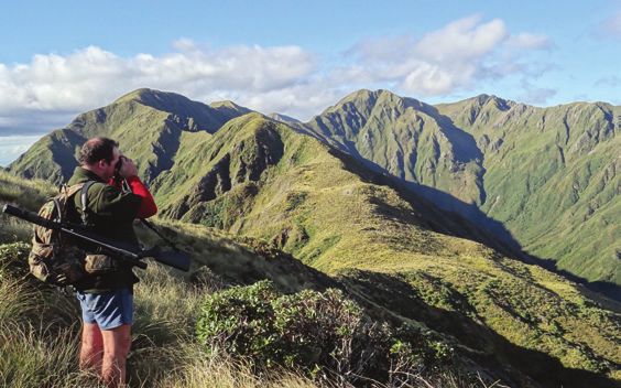
Holdsworth
Getting there
Turn off SH2 into Norfolk Road, 2 km south of Masterton.
Follow signs to Tararua Forest Park, approximately 15 km
from SH2.
Vehicle access
Sealed road to Holdsworth suitable for all types of vehicles.

Attractions: This is the main entrance to the eastern side
of the Tararua Forest Park.
Caretaker on site.
                                                                                                                  Tararua Bush. Photo Joe Hansen

       Donnelly Flat Loop
       Walking track. Length: 1 hour round trip, 2.5 km                                  Rocky Lookout
                                                                                         Walking track. Length: 1 hr 30 min one way, 1.9 km
Cross the Atiwhakatu footbridge and follow the relatively
flat track to Donnelly Flat camping area. From here the track              Follow the well-graded Gentle Annie track from the Loop
continues to the Atiwhakatu Track junction, and loops back to              Walk to a viewing platform with extensive views of Powell
the Holdsworth car park via the foot of the Gentle Annie Track.            Hut, Mt Holdsworth, Jumbo Hut, Mitre Flat, Atiwhakatu
                                                                           valley and the plains out east.

                                                                                  Atiwhakatu Hut
                                                                                  Walking track. Length: 3 hr one way, 7.2 km

                                                                           Follow the walk past Donnelly Flat. Well-developed track
                                                                           running through bush and alongside river.

                                                                                         Holdsworth Lookout
                                                                                         Tramping track. Length: 1 hr one way, 1 km

                                                                           Cross the Atiwhakatu footbridge and continue up a steep
                                                                           forest-clad spur to a clearing with magnificent views.

                                                                                  Other tramping tracks to huts
                                                                                  Including Powell, Jumbo, Totara Flats and Mitre Flats huts

                                                                           More details can be found at
                                                                           http://www.doc.govt.nz/Holdsworth

8                             Mount Holdsworth Roadend. Photo Joe Hansen                                                                           9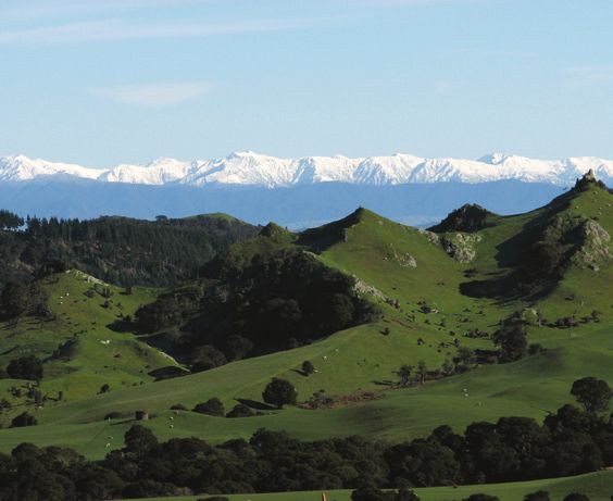
HISTORIC SITE
Waiohine Gorge Cone hut
Getting there
Turn off SH2 just south of Carterton into Dalefield
Road. Follow the signs indicating Tararua Forest Park,
approximately 15 km from SH2.
Vehicle access
Unsealed road for final 9 km.
Attractions: Popular camping and recreation area, and
entrance to south-eastern Tararua Forest Park.
Spectacular swingbridge, rafting, tubing and kayaking (grade
II) and several swimming holes.
Totara Flats Hut
Easy tramping track. Length: 4 hr one way, 10 km
L ocated in the upper Tauherenikau valley, in the south
eastern section of Tararua Forest Park, Cone is the
second-oldest hut in the Tararuas and was constructed
by New Zealand’s first tramping club, the Tararua
Tramping Club.
Cone Hut
Cone Hut was built using local tōtara timbers, adzed into
Tramping track. Length: 3 hr one way, 4.6 km
framing and split into slab walls. This was a very rare form
of construction by the 1940s.
By the early 1980s the hut had fallen into a state of disrepair.
After assessing the heritage importance of the site and
developing a plan, it was decided to rebuild the hut using
the same construction method and materials as in 1946. This
work was undertaken by the Tararua Tramping Club with the
assistance of the Department of Conservation.
The hut’s restoration in the late 1980s is a credit to the
Tararua Tramping Club volunteers and their predecessors
who had the bush carpentry skills to fashion such a
durable haven.
Situated in picturesque mature forest adjacent to the
Tauherenikau River, this rustic hut continues to be used
and enjoyed by trampers and hunters.
10 Headwaters of the Waiohine River. Photo Joe Hansen 11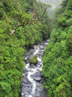
Vehicle access
Kaitoke
                                                                          Unsealed road for 8 km. Parking for large vehicles.
Getting there
Turn off SH2 into Marchant
Road at the YMCA Camp
Kaitoke turnoff . Near the end of                                         Attractions: Track to the Tauherenikau River.
Marchant Road, turn right into
Kiwi Ranch Road. The car park is
located on the left, approximately                                        Kaipaitangata
500 m along Kiwi Ranch Road.                                              Getting there
                                           Spider Orchid – Nematoceras
Vehicle access                             trilobum. Photo Jeremy Rolfe   Southern end of Carterton, turn into Dalefield Road
Sealed to the car park.                                                   and follow for approximately 8 km.
Attractions: Southern entrance into Tararua Forest Park                   Vehicle access
which contains rare orchids and plants. Hunting access                    Unsealed road for 4.5 km.
to the lower Tauherenikau valley.

       Smith Creek to Tauherenikau River
       Walking track. Length: 4 hr return, 5.5 km                         Attractions: Drive towards Mt Dick lookout for great views
This track takes you over the Puffer Saddle and down Smith                of the Wairarapa valley and eastern hills on a fine day.
Creek with its fine stands of red beech/hard beech forest,                See the Mountain bike section p. 53 for more information.
to its confluence with the Tauherenikau River.

                                                                          Upper Waingawa Road
       Dobson Loop Track
       Tramping track to Smith Creek Shelter and return.                  Getting there
       Length: 5 hr round trip.                                           From Masterton turn off SH2 into Upper Plain Road and then
This day tramp leads from Kaitoke to Smith Creek Shelter, at              into Upper Waingawa Road to the Pines car park.
the junction of the Tauherenikau River and Smith Creek. The               Vehicle access
shelter can be reached either from the Dobson Loop Track, or              Unsealed road towards end. No suitable car parking for large
the Puffer Track over Puffer Saddle and down Smith Creek.                 vehicles.
The track along Smith Creek crosses unbridged side streams
which can become hazardous during heavy rain. Please follow
track markers when crossing these streams, but do not attempt
to cross if flooded.
                                                                                 Mitre Flats Hut
                                                                                 Tramping track. Length: 4 hr one way, 8 km
Bucks Road/Underhill road
                                                                          This track follows a farm access road for the first 30 min
Getting there
                                                                          then the track sidles up the true left of the Waingawa River,
At Featherston turn into Wakefield Street, opposite Western               reaching Mitre Flats Hut.
Lake Road. This becomes Underhill Road and then Bucks
Road. Follow to the end.

12                                                                                                                                        13
Mikimiki                                                               Kiriwhakapapa
Getting there                                                          Getting there
Turn off SH2 10 km north of Masterton into Mikimiki Road.              About 15 km north of Masterton turn off SH2 into
Follow signs to Tararua Forest Park.                                   Kiriwhakapapa Road. Follow signs to Tararua Forest Park,
                                                                       approximately 7 km from SH2.
Vehicle access
Unsealed road for last 7 km.                                           Vehicle access
                                                                       Unsealed road for the last 4 km.

        Tramline track (Mikimiki to Kiriwhakapapa)                     Attractions: Popular pretty camping area with lovely stream
        See the next page.                                             and entrance to north-eastern Tararua Forest Park.

                                                                                 Kiriwhakapapa Loop Track
                                                                                 Walking track. Length: 1 hr, 1 km

                     Waiohine bats                                     A gentle climb on a loop track through native bush.
                                                                       Not suitable for pushchairs or wheelchairs.

                                                                                 Tramline Track (Mikimiki to Kiriwhakapapa)
                                                                                 Walking track. Length: 2 hr one way, 7.5 km

                                                                       This is a one-way track following an old timber mill tramway
                                                                       for 1.5 km over a low saddle through native bush. It then
                                                                       becomes walking track with a steeper gradient.
                                                                       See Mountain bike section p. 53 for more information.

                                                                                 Blue Range Hut Track
 Waiohine bat pup.                                                               Tramping track. Length: 2 hr one way, 3.6 km

A    round 200 short-tailed bats were found in the Waiohine
     valley of the Tararua Forest Park in the late 1990s. It’s
the only known colony in the southern North Island.
These small, grey bats weigh between 12 and 15 grams, have
large pointed ears, and a free tail. Their diet consists of insects,
fruit, nectar and pollen and they hibernate over winter.
They forage on the ground and are one of the few bats in the
world that spend time on the forest floor, using their folded
wings as ‘front limbs’ for scrambling around. These bats are
nocturnal and don’t like to be disturbed.

                                                                       Blue Range Hut. Photo: Mikis van Geffen

14                                                                                                                                15
Putara                                                                                                  Kākā
                                                                               B
Getting there                                                                      oisterous kākā are plentiful around northern Wairarapa
Turn off SH2 north of Mt Bruce onto South Road No.2                                since their reintroduction to Pukaha Mount Bruce, and
for approximately 15 km and follow the signs for Tararua                       can sometimes be seen in the Tararua Forest Park.
Forest Park.
Vehicle access
Unsealed road which narrows close to the forest park. Suitable
for some campervan parking for access only.

       Tramping track
       Length: 1 hr 30 min return, 1.5 km

From the road end go up the true right for 10 min. Go over the
swingbridge and walk up the Mangatainoka River on the true
left towards a large swingbridge, and return. Can continue on
steep uphill to Herepai Ridge and onto Herepai Hut or down
to Roaring Stag Hut (a further 1 hr or 2 hr, respectively).

                                                                               A parrot native to New Zealand, kākā compete with
                                                                               possums for food such as native mistletoe and rātā. They
                                                                               ‘chatter’ loudly in the early morning and late evening and
                                                                               are a beautiful bird.
                                                                               See kākā feed at Pukaha Mount Bruce at 3 pm daily.
                                                                               See page 36 for more information.

16                         Tararuas from Pukaha Mt Bruce Photo: Tony Silbery                                                                17
Holdsworth
MASTERTO
W
Mangatarere
ain
Rimutaka Forest Park
ga
Cross Creek
Waiohine
wa
The 22,000 ha Rimutaka Forest Park encompasses much of the Getting thereGorge DOC W
2
Ri
Rimutaka Range. The main entrance to the park is from the Area O
ve
From Featherston turn into Moore St, continue into Western
r
Catchpool Valley recreational area in the Wainuiomata Valley Lake Road, and turn right onto Cross Creek Road.
with smaller entrances from road ends in the Wairarapa. Kaipaitangata
It provides visitors with tramping, hunting and walking
Vehicle access CARTERTON
opportunities in a wild, natural landscape. Kaitoke Unsealed road W
from
ai oWestern
hi ne RivLake
er Road.
Good parking facilities.
Bucks Rd
2 GREYTOWN Carter
R i v er
Scenic
R.W. Tate Reserve
UPPER Attractions: Scenic
Historic rail site. Reserve
HUTT FEATHERSTON
Rimutaka
k au
Rail Trail
en i
53
page 19 Cross Creek
er
u h
Ta
LOWER
HUTT Lake er
iv
Wairarapa MARTINBOROUGH
aR
page 22 Waiorongomai
ng
a
mah
a
RIMUTAKA Ru
FOREST Cross Creek. Photo: Joe Hansen
Catchpool PARK Papatahi/
page 22 Onoke Rimutaka Rail Trail
Access EASIEST Walking track. Length: 5 hr one way,
2 hr mountain bike ride, 18 km
page 23 Corner
Creek Lake This track follows the old Rimutaka Incline, a unique rail
Onoke system built in 1878 and designed to traverse the steep
eastern side of the Rimutaka Range.
Backcountry hut
Turakirae Head See the following pages for further historic information.
Putangirua
Scenic Reserve The rail trail is a gently graded 18 km walk or mountain
Booked
Palliserhut
Bay/ lodge bike ride. This makes it an ideal trip for families with children.
(exclusive use) The trail is also popular with dog walkers.
Backcountry hut
AORANGI
DOC land / access point FOREST
Booked hut / lodge (exclusive use) Education resources
Track (walking, tramping, route)PARK
DOC land / access point
For education resources on the rimutaka incline please visit:
www.doc.govt.nz/fieldtrips Tora
Track (walking, tramping, route)
0
0
10
10
20 km
20 km 19HISTORIC SITE
Rimutaka Rail Trail
The system was considered a temporary measure but
the world wars and depression of the 1930s meant that
the replacement was not ready until 1955, by which time
the journey was slow and expensive.
Today, the incline is regarded as a special part of
New Zealand’s historic heritage and one of the 10
most significant railway heritage sites in the world.
It has made its mark in the following ways:
• It is technically remarkable how maintenance staff kept
the original 1877 equipment operating reliably at full
power for 77 years.
• For the Wairarapa community, the aged equipment
became a cultural legend, with many personal
experiences of the journey recorded and published. A
children’s story was even written about it, Freddy the Fell
Engine, by Peter Walsh.
• For railway staff and their families, Cross Creek became
New Zealand’s most legendary ‘railway settlement’. The
closure of the incline on 29 October 1955 attracted large
crowds and national media coverage.
Rimutaka incline.
A n ambitious government project to construct a
national railroad to attract immigrants began in
1871. When building a connection from the Wairarapa
to Wellington the mountainous terrain posed a major
challenge to the construction.
Using a system that English engineer John Fell had
patented in 1863 that worked successfully on Mt Cenis in
the European Alps, New Zealand decided to attempt the
4.8 km Rimutaka Incline. This was an innovative and bold
engineering solution. It involved a centre rail—elevated
above the running rail—gripped by a series of horizontal
wheels fitted to the specially designed engines and brake
vans which took trains up and down the incline.
20 21Waiorongomai Corner Creek/Ocean Beach
Getting there Getting there
From Featherston travel down Western Lake Road for From Featherston travel down Western Lake Road
approximately 18–20 km after leaving the lakeshore reserve. to the beach and follow round to Corner Creek.
If you cross the Waiorongomai Stream you’ve gone too
Vehicle access
far. Walking access into the Rimutaka Forest Park, via
Unsealed road for at least 3 km with two stream fords.
Waiorongomai station, is by the goodwill of the Matthews
Suitable for large vehicles.
family. Hunters and all others with dogs require permission
from Mr C. G. Matthews, phone 06 307 7740.
Vehicle access
Unsealed short road with plenty of car parking (no camping).
Mukamuka Track to Mt Matthews (South Saddle)
Waiorongomai Hut walk Tramping track. Length: 4 hr one way, 6.2 km
Tramping track. Length: 1 hr 30 min one-way, 4.8 km
Walk down the beach to the big Mukamuka Stream
Walk up the Waiorongomai Stream and Track to the hut. and follow the streambed to the track over south saddle.
Papatahi/Onoke Farm access
Getting there
From Featherston travel down Western Lake Road past
the East/West access road and look for Onoke access signs.
If you cross the first one-way bridge you’ve gone too far.
Vehicle access
Park in the car park on the side of Western Lake Road.
Not suitable for large vehicles.
Wharepapa Hut Walk
Tramping track. Length: 2 hr 30 min one way, 6.5 km
This follows an easement through Onoke farm to Battery
Stream and Wharepapa River and the hut.
Wharepapa Hut over Papatahi Crossing
(to Catchpool Valley)
Length: 10 hr one way, approximately 20 km
Ocean Beach.
22 Photo: Joe Hansen 2353
Cross Creek
er
h
T au
Aorangi Forest Park
Lake er Putangirua Scenic Reserve
iv
This area, locatedWairarapa
in south-eastern Wairarapa, is popular MARTINBOROUGH
Getting there
aR
with recreational hunters and trampers. It contains some of
rongomai Located 13 km along Cape Palliser Road from the Lake Ferry
ng
a
New Zealand’s most striking landforms and has significant
m ahfrom
Māori history. The park is 19,374 ha and stretches
turnoff, approximately a 1 hr drive from Martinborough.
a The turn-off and campsite are 500 m past the Department
A Martinborough to the Palliser Bay coast. Ru of Conservation’s bookable Te Kopi Lodges.
Vehicle access
Unsealed road for 500 m. Suitable for various vehicles,
including buses.
Pinnacles Track
Lake
AORANGI Walking track. Length: 2-4 hr depending on the route,
Onoke 3.5 km
When the Aorangi Range was an island, 7 to 9 million years
FOREST ago, screes poured gravels onto the coast, much as they do
today around Cape Palliser.
The Putangirua Stream has exposed this ancient layer
Putangirua of gravels to the erosive forces of rain and floods. Where
Scenic PARK cemented silts or rocks within the gravel beds prove more
page 25
resistant than the underlying sediments, spectacular
Reserve individual pinnacles or ‘hoodoos’ are formed.
Palliser Bay
Tora
Backcountry hut
Booked hut / lodge
(exclusive use)
DOC
Cape land / page
Palliser access
27
point
Track (walking,
Backcountry hut tramping,
DOC route)
land / access point
Booked hut / lodge Track
(exclusive use) (walking, tramping, route)
00 10
10
20
20 km
km
Pinnacles from the lookout. Photo: Joe Hansen 25Three routes lead to the Putangirua Pinnacles or the Old Mill Track (to Sutherlands Hut)
Pinnacles lookout: Tramping track. Length: 3 hr one way, 8 km
1 W
alk up the streambed to where the Pinnacles tower
From the car park at the saddle above Waikuku Lodge
overhead (watch for falling rocks, especially after heavy
(see p 62), follow the Old Mill track around the west branch
rain and in strong winds).
to Sutherlands Hut.
2 T
ake the easily-graded bush walk that starts approximately
10 min along the streambed from the car park. This leads
to the loop track junction and on to the lookout above the Pig Ridge Track (to Sutherlands Hut)
Pinnacles. Tramping track. Length: 1 hr 30 min one way, 4.5 km
3 For a more direct route to the lookout, walk up the streambed Follow the Old Mill Track and turn left on this alternative
to the base of the Pinnacles and turn left onto the loop track. and shorter route to Sutherlands Hut.
This track climbs steeply to the lookout and meets up with
the bush walk.
For a longer walk with excellent views of Palliser Bay and Mangatoetoe Stream
Lake Onoke, continue uphill from the lookout to a bulldozed Getting there
track and turn left. It returns you to the coast 300 m from Drive to Ngawi on Cape Palliser Road and access is
the Pinnacles Road entrance, behind the bookable Te Kopi
approximately 4 km beyond Ngawi. Legal walking access
Lodges. Allow 3–4 hr for the return trip.
is up the true left of the streambed to the park boundary.
Vehicle access
Park in the car park just off Cape Palliser Road.
Mangatoetoe Hut from Coast Road
Tramping track. Length: 1 hr one way, 4 km
Walk up the streambed to the hut.
Ngapotiki section on the Cape Palliser Coastal Walk.
Photo: Joe Hansen Follow this track to Kawakawa Hut, Pararaki Hut and
Washpool Hut (approximately 4 hours between each hut).
Haurangi Road
Getting there Cape Palliser
Take White Rock Road south of Martinborough, turn right
into Ruakokoputuna Road about 10 km from Martinborough Cape Palliser Coastal Walk (unmarked walk)
and follow the road to the end. Walking track. Length: 3 hr one way, estimated 9 km
Vehicle access From the Cape Palliser lighthouse, walk around the coast past
Unsealed from White Rock Road and unsuitable the Stonewall to Ngapotiki. There is no vehicle access unless
for large vehicles. organised with local hapū (Māori tribe).
26 27Seal colony
N ew Zealand fur seals have clearly visible external
ears, a pointed snout and long pale-coloured whiskers.
Adult males reach about 2 m long (nose to tail length)
and weigh up to 185 kg. Adult females reach 1.5 m long
and weigh up to 70 kg.
The coat of fur seals is dark grey-brown on the back, and
lighter below. They have a thick underfur which is a rich
chestnut. In some animals the outer guard hairs have white
tips giving them a silvery appearance.
Fur seals are excellent swimmers and skilful divers.
They feed mainly offshore and at night on squid, lantern
fish, barracouta and, in some places, hoki. Photo: Joe Hansen
In rookeries, dominant males rule, defending their
territories by posturing and fighting chest-to-chest until
one male submits and leaves. Females give birth to a pup
each year and mate again 8–10 days after birth. They will
occupy the rookeries almost throughout the year, until
they have weaned their pup. Outside of the breeding
season, adult males and non-breeders tend to move around
various non-breeding colonies. Haul-outs are occupied by
immature and adult males in the winter and empty around
October, just before the next breeding season starts.
Fur seal care code
Photo: Joe Hansen • Fur seals are wild animals, so it pays to keep a
safe distance from them. Where practicable stay
at least 20 m away.
Habitat
• Avoid coming between seals and the sea.
Although seals are marine mammals they spend much
• Keep dogs on a leash and well away.
of their time on land, either to rest at ‘haul-out’ areas, or to
• Where practicable, do not drive vehicles within 50 m
breed at ‘rookeries’. The breeding season at the Cape Palliser
of a marine mammal.
rookery runs from November to January.
• Never attempt to touch seals—they can be aggressive
and often carry diseases.
• Unless there is a good reason to think a seal needs
assistance, it should be left alone. Seals can survive
quite major injuries if they are in good condition.
• If you see a sick or injured seal, do not attempt to move
or assist the animal yourself. Please contact your nearest
DOC office. DOC has experienced staff who will respond
to the animal if necessary.
28 29Carter Scenic Reserve R.W. Tate Scenic Reserve
The land was gazetted as scenic reserve in 1921. It contains Getting there
swamp and semi-swamp forest on two old terraces of the East of Greytown on Papawai Road is a small reserve with
Ruamahanga River, and is representative of the patchwork a short walking track.
landscape that was once typical of the Wairarapa—grass,
Vehicle access
wetland, shrubland and forest.
Tar-sealed to a small entrance. Park on the side of the road;
Getting there not suitable for large vehicles.
The reserve is 12 km south-east of Carterton, on Gladstone
Road. From Carterton follow Park Road to the end, turn left
into Carters Line and right into Gladstone Road. The reserve
is signposted approximately 3 km along Gladstone Road.
The carpark is about 500 m along the driveway.
Vehicle access
Unsealed road to the car park.
Kahikatea Walk
Short walk. Length: 30 min return, 1 km
Follow the boardwalk and return via the bush track.
Makuri Gorge Reserve. Photo: Joe Hansen
W.A. Miller Scenic Reserve
Getting there
Turn left where signposted north of Pukaha Mount Bruce
on SH2.
Vehicle access
Sealed car park. Suitable for 1–2 campervans or cars.
Loop track through tawa forest and over bridge.
Short walk. Length: 15 min return, 600 m
Walk through to the historic ANZAC bridge.
Short walk. Length: 15 min return, 600 m
30 Carter Reserve boardwalk 31Carnival Park Scenic Reserve Castlepoint Scenic Reserve
Getting there With its fossil-rich limestone reef and magnificent 162 m high
Adjacent to the Carnival Park Camping Ground south Matira/Castle Rock, Castlepoint is one of the most spectacular
of Pahiatua. sites along the Wairarapa coastline. Long stretches of beach
and a sheltered lagoon provide opportunities for a variety
Vehicle access
of water-based recreational pursuits, and the area has a rich
Sealed to the car park; suitable for large vehicles. natural history.
Castlepoint.
This park contains a loop track through mature
tawa forest.
Easy tramping track. Length: 30 min return, 800 m
Vehicle access
Sealed road to the car park; suitable for large vehicles.
Beach access.
Caution: The area known as ‘The Reef’ is extremely
dangerous and sea conditions are unpredictable.
Lighthouse Walk
Short walk. Length: 30 min return, 700 m
Walk across the beach and up the limestone reef towards
the lighthouse. Please be careful in high winds.
32 Castlepoint Lighthouse. Photo: Joe Hansen 33Deliverance Cove Track
Walking track. Length: 1 hr 30 min loop, 2.5 km
Walk through the pines above the lagoon and follow the
reserve boundary path along the bottom of Matira/Castle
Rock. Alternatively walk south along the lagoon edge and
follow the track up through coastal grassland to meet the
boundary track at the saddle.
Honeycomb Rock
Honeycomb Rock is a spectacular outcrop on the Wairarapa
coast, named for the remarkable cell-like weathering pattern
which gives the rock a honeycomb appearance.
Getting there
Glenburn Station is about 60 km east of Masterton. Follow
Gladstone Road to the Te Wharau Road junction about 1 km
north of Gladstone. The road is signposted to Glenburn from
here and passes through Te Wharau Settlement.
Vehicle access
Honeycomb Rock. Photos: Joe Hansen Unsealed for approximately 25 km (from Te Wharau).
Small car park.
Honeycomb Rock Walking Track
Walking track. Length: 3 hr one way, 8.5 km
The gazetted walking track is entirely within the privately
owned Glenburn Station. The track is flat and easily negotiated,
following the coastline across farmland. It can be muddy in
places so suitable footwear should be worn.
Please respect the property and do not interfere with or
disturb stock. The walkway is closed for lambing during
September and October.
34 35Pukaha Mount Bruce
Pukaha Mount Bruce. Baby kiwi.
Photo: Pukaha Mount
Bruce Wildlife Trust
Takahe.
H ome to Manukura, the world’s only white kiwi in
captivity, Pukaha Mount Bruce Visitor Centre is set
against a backdrop of 942 hectares of forest, into which
Opening hours
Open daily from 9 am to 4.30 pm. Closed Christmas Day.
native wildlife is being returned. Admission charges apply.
Pukaha Mount Bruce has six daily talks and feeds starting Website: www.pukaha.org.nz
with takahē at 10.30 am, tuatara at 11.30 am, the kiwi chick Ph: 06 375 8004 Email: info@pukaha.org.nz
or gecko talk at 12 noon, eel feeding at 1.30 pm, the kōkako Getting there
talk at 2.15 pm and kākā feeding at 3 pm.
Pukaha Mount Bruce is located on SH2, 30 km north of
Visitors can see rare and endangered New Zealand birds in Masterton and 10 km south of Eketahuna on SH2.
aviaries but also other native birds living wild in the forest
such as tūī, fantail, kererū and rifleman. Vehicle access
Sealed road and car park. Space for campervans and buses
There is a kiwi house with two resident kiwi, an egg and to park.
chick nursery, a theatre that plays three short films and
an interactive gallery. There is a 2-hour loop walk through
regenerated native bush and a shorter aviary walk.
Wild Cafe at Pukaha overlooks the takahē enclosure
and serves freshly prepared food and coffee daily.
36 37Wairarapa Moana Wairarapa Lakeshore Scenic Reserve
Located in South Wairarapa, Wairarapa Moana describes the The only place on Lake Wairarapa where the native
catchment of Lake Wairarapa, Lake Onoke and their tributary vegetation extends uninterrupted from the Rimutaka Range
rivers and associated wetland areas. One of the largest wetlands to the edge of the lake.
in New Zealand, Wairarapa Moana is considered the jewel in
Getting there
the crown of the lower North Island with many indigenous
species (such as tuna, flounder and birds) calling it home. Located on the western shore of Lake Wairarapa approximately
16 km southwest along Western Lake Road from Featherston.
This area is co-managed by a governance board with
representatives from local iwi and hapū, Greater Wellington Vehicle access
Regional Council, South Wairarapa District Council and the Park in camping or picnic areas at the reserve off Western
Department of Conservation. Lake Road.
ton Featherston
Pounui Wetland
ing
Good views over a large natural wetland area. Follow walking
ll
We
To
To Masterton
To
M
tracks along the top of stopbanks.
ar
tin
bo
ro
ug
h
Rd
Getting there
Rd
Rd
ke
Line
La
ton
rn
te
hers
es
phys
Travel southwest along Western Lake Road from Featherston
W
Ri auh Sth Feat
Mur
au
ik
for approximately 30 km.
r ren
Lake Domain
ve e
Rimutaka
Rail Trail
T
Vehicle access
Rimutaka
pa
Forest
Park Park on the short section of gravel road between the boundary
fence and Western Lake Road.
Lake Wairarapa
Wairarapa Lake Shore
ds Scenic Reserve
Kahutar
a Rd
Wairio Wetlands
Waioro
Parera Rd
ngomai
River
er
Riv
Boggy Pond ga
an
Onoke Spit
mah
Rua
Allsops Bay
Pir
ino
aR
d A 3 km sandspit between Lake Onoke and the Pacific Ocean,
gh Legend
t Ac
ce
ss
Rd
Ma
rtin
bo
rou
Easy walking
good for beach walking. A habitat for rare native plants and
bird species.
es
Barrage st
W Keep dogs under control
Gates Ea
Carpark
Kohunui
Rd
Getting there
marae Picnic area
Lake
Toilet
rn
Weste
Aorangi
Forest
Bird watching
Birds nesting
Located approximately 34 km southwest of Featherston along
the Western Lake Road. The road forks 1 km from the spit.
Pirinoa Park
Pounui Seasonal game bird shooting
Lagoon
Turn left onto the gravelled Beach Road and follow to the end.
Fishing
Camping
Rimutaka Cycle Trail
Lake Onoke
0 1 2 3 4 5 Track to birdhide Vehicle access
Lake Ferry/
Sealed road to Beach Road then last 1 km to the car park is
Onoke Spit Onoke Lagoon Native vegetation
km
Exotic vegetation
Ca
pe
Grassed mud flats gravel. Park in the informal car park on the landward side
of a small stream.
Pa
llis Beach gravel
er
Rd
Palliser Bay
Water
38 39Lake Domain Reserve Lake Ferry settlement/Lake Onoke
Camp, picnic and walk beside Lake Wairarapa and adjoining Picnicking, beach and lakeside walking, and bird watching.
wetlands.
Getting there
Getting there Take the Martinborough–Lake Ferry Road.
From SH2 just north of Featherston, turn south into Murphys
Vehicle access
Line and follow for 5 km. Turn right into Lake Domain Road
Sealed road to Lake Ferry. Off-road parking and a picnic area
then turn left 1.5 km along this road. The domain is 500 m
are available at the end of the settlement on the lakeshore.
south of the turn-off.
There is an unsealed, narrow, shared pedestrian/vehicle track
Vehicle access to the beach and lagoon.
Parking is available at the gate, at the campsite and near
the footbridge to the east of the entrance.
Tuna (eel)
Wairio Wetlands and Boggy Pond Reserve
Bird hides at Boggy Pond and on the Wairio lakeshore allow
views of wading birds, waterfowl and migratory birds. There
A mysterious
freshwater fish once
found in abundance around
Eel.
are walking tracks around Boggy Pond along a stopbank,
Wairarapa, tuna are now
as well as board walks to the lakeshore, and informal walks
threatened and is an iconic
around Wairio wetlands. This habitat contains endangered
species that should be
native wetland plants. admired and looked after.
Getting there Eels spawn in Tonga, a long
From SH53, just out of Featherston, turn right into Kahutara way from Wairarapa. As
Road then right into Parera Road (unsealed). Boggy Pond tiny elvers (about 50 mm) they follow the sea currents from
is on the left about 5 km along Parera Road. Access to the Tonga to New Zealand, making their way to river mouths
Wairio lakeshore walk is via a stopbank across the road from and then upstream to their new homes.
the Boggy Pond car park. Shortfin eels can generally be found downstream in areas
such as Wairarapa Moana, whereas more endangered
Vehicle access
longfin eels travel further inland to areas such as Pukaha
Unsealed parking area adjacent to the road at Boggy Pond. Mount Bruce.
Shortfin eels have a lifespan of between 15 and 30 years,
longfin eels anywhere between 25 and 80 years. Towards
the end of their lives, they start their migration back to the
waters of the Pacific Ocean where they breed once and die.
Fishing for eels used to be common around New Zealand
but as numbers decrease there are fewer to be caught.
Longfin eels are a threatened fish and the Department
of Conservation is an advocate for their protection.
View eels feeding at Pukaha Mount Bruce daily at 1.30 pm.
Caspian terns at Onoke Spit. See page 36 for more information.
40 Photo: Jenny Whyte 41Wairarapa tangata whenua: Cape Palliser Road and the pā of 19th century chief Wereta
Kawekairangi at Glenburn (Wharaurangi) on the east
O U R H E R I TA G E S T O R I E S A N D S I T E S coast. There are numerous other man-made features and
plantings that are readily viewable in coastal areas. They
T he tangata whenua of the Wairarapa Region are the
iwi of Rangitāne o Wairarapa and Ngāti Kahungunu
ki Wairarapa. Through shared ancestry the people can
are particularly prominent along the Palliser Bay Road and
remain as monuments to our early ancestors.
celebrate a long and enduring relationship with the land Kupe
and coastal areas. This section introduces visitors to the Approximately 28 generations ago (sometime in the
Māori heritage of this public conservation land. 14th century) another explorer named Kupe sailed to New
Māui Zealand from his Pacific home of Hawaiki. Kupe’s wife
Hine-i-te-apa-rangi is credited with spotting a cloud on
Māui, the demigod of Polynesian mythology, hauled up
the horizon and exclaiming, ‘He ao, he ao’ or ‘a cloud, a
the giant fish Te Ika-a-Māui out of the depths of the Pacific
cloud’ from which the commonly accepted Māori name
Ocean. Māui’s fish has an unbelievable resemblance to a
for New Zealand is derived. Aotearoa – Land of the Long
huge pātiki or flounder. The head of the fish, Te Upoko-o-
White Cloud.
te-Ika, encompasses the modern Wairarapa and Wellington
regions. Its saltwater eye is Wellington Harbour while the
freshwater eye is Lake Wairarapa. The lower jaw is Turakirae
Head and the upper jaw Cape Palliser, the western and
eastern extremes of Palliser Bay. The fish’s spine became
the central mountain chain that starts with the Rimutaka
mountains, carries on to the Tararua mountains, and then
stretches right up the middle of the North Island.
Within this mythology we find the earliest connections
to the Wairarapa region for both Māori and the
Department of Conservation.
Early people
There was a real man called Māui who was a great
explorer in the Pacific region. His contemporaries may
have been the first people that made their homes on
the Wairarapa coast after sailing from Polynesia in the
12th century. Some of the country's earliest inhabited
sites are found along the Wairarapa coast, including
historically interesting places on or near Department of
Conservation land including the Washpool Valley on the Nga Ra O Kupe. Photo: Joe Hansen
42 43The orthodox version of events sees Kupe chasing the made their home at Heretaunga, today the province of
pet octopus of his enemy Muturangi across the Pacific. Hawke’s Bay. His sons Tara Ika and Tautoki and grandson
After sailing down the east coast Kupe catches up with the Rangitāne remain important figures to this day.
octopus in a cave underneath what we now call Castlepoint. During a journey of exploration Whatonga spent a long
Although he does not slay the giant fish there he eventually time away from home. In the early part of his long trip
catches up with and kills it at the top of the South Island. he established a pā called Matirie where the Castlepoint
Throughout the Pacific, stories of Kupe and the octopus Lighthouse stands today. Sometime later while walking
abound. Interestingly, wherever the octopus appears so across a mountain range a long way to the west he came
does a water hazard. Beware of the octopus at Castlepoint into a clearing. He missed his wives and when looking
because, as a Department of Conservation sign points out, at ‘twin peaks’ in the distance thought of them. This is
it is in fact a dangerous reef with a strong undercurrent. how the first name for the Tararua mountain range came
There are various versions of how long Kupe stayed in the about. At the same time he looked to the east and saw a
Wairarapa yet his legacy remains through the continued forest so vast that he named it Te Tapere Nui o Whatonga
use of names that he gave to many natural features and/ or the great domain of Whatonga. This stretched from
or stories associated with him. The Māori name for Opaki north of Masterton to the Takapau plains in central
Castlepoint is Rangiwhakaoma, which literally means Hawke’s Bay. It was called the Seventy Mile Bush by early
‘where the sky runs’ or alternatively, is the personal name European settlers but was virtually destroyed between
of a man who came to New Zealand with Kupe. Or perhaps 1872 and 1900. The only major remnant to remain was the
the reef structure represents the reclining body of Kupe 942 hectare Mount Bruce Reserve. The site of the National
himself, where the reef is his body and Matira (lookout) or Wildlife Centre has had its original name Pukaha returned
Castle Rock is his head. to it and has started to take on its earlier functions of
The personified form of a natural occurrence was used mātauranga (knowledge), pātaka (pantry) and rongoā
to represent Kupe’s claim over ownership of the land. At (medicine), but with a conservation focus.
Glenburn is Honeycomb Rock, where Kupe looked out to Later Whatonga’s son Tara Ika became the eponymous
sea to await the arrival of family members. ancestor of an iwi called Ngāi Tara. His territories
The Māori know Palliser Bay as Kawakawa, in straddled the Tararua mountains which lead to a second
commemoration of Kupe’s daughter making him a meaning ‘The span of Tara’ in reference to his people
wreath of kawakawa leaves. Near Cape Palliser are the having a foot on either side of the Tararuas.
rock formations known as Nga Ra O Kupe or Kupe’s sails, Rangitāne, the son of Tautoki, is the person after whom
which were said to have been placed there by Kupe after the Rangitāne o Wairarapa iwi is named. The full name
a sail-making race with his friend Ngake. of Kapiti Island off the west coast is Te Waewae Kapiti
o Rangitāne raua ko Tara or the boundary of Rangitāne
The Kurahaupō Waka
and Tara. This meant that if a straight line was drawn
Whatonga was the captain of the ancestral canoe called from Kapiti Island to Castlepoint, land to the north was
Kurahaupō. He came from Hawaiki in search of his predominantly Rangitāne and that to the south Ngāi Tara.
grandfather Toi-te-huatahi. Whatonga and his family
44 45Haunuiananaia was another passenger on the Kurahaupō. The people of Ngāti Kahungunu eventually spread out
His story unfolds after his wife eloped with two slaves. through Wairarapa. By the 19th century Ngāti Kahungunu
Haunuiananaia pursued them across the centre of the occupied both sides of the Rimutaka Ranges and had
North Island and down the West Coast before distributing numerous pā tuna (seasonal eeling villages) around Lake
some rough justice to the threesome. He then decided to Wairarapa. Hapū with strong Ngāti Kahungunu ancestry
return to his home on the east coast. While doing so he became guardians of the Aorangi Ranges, the southern
named a number of prominent landmarks. Even though east coast and Palliser Bay.
the spelling of names may have changed somewhat, they Te Heke Rangātira o Nukutaurua
are all still used today. All except one place (the ancestral
A series of events that occurred before the first quarter
mountain Rangitumau to the north of Masterton) are
of the 19th century led to tangata whenua living in exile
within the Department of Conservation-managed
for more than a decade. The displacement of a majority
lands. Haunuiananaia named the Rimutaka mountains
of Rangitāne and Ngāti Kahungunu became known as
to the south-west of Featherston, Lake Wairarapa, the
Te Heke Rangātira o Nukutaurua. Nukutaurua is a place
Tauherenikau River to the east of Featherston, the
on the Mahia peninsula north of the town of Wairoa
Waiohine River to the west of Greytown, the Waingawa
in Hawke’s Bay. Refugees from the Wairarapa lived
River to the south-west of Masterton, the Waipoua River
at Nukutaurua or within the shelter of Te Tapere Nui
to the north-west of Masterton and the Ruamahanga River
o Whatonga while waiting to return home.
from which the main Wairarapa valley was formed.
Iwi from Wellington had been coming over the Rimutaka
The Tākitimu Waka mountains which eventually led to skirmishes with
Ngāti Kahungunu ki Wairarapa iwi are descendents Wairarapa hapū. The problems escalated to the point
of Tamatea Ariki Nui, captain of the Tākitimu ancestral that Wairarapa tangata decided to retreat to their old
canoe. The iwi name is taken from a politically astute and homelands.
industrious man called Kahungunu. This famous ancestor One significant battle was at Wharepapa near the western
is also remembered for his good looks and virility. After shores of Lake Wairarapa. On this occasion Wairarapa
making landings along the eastern side of the North won but it caused their foe to come back with greater
Island, the Tākitimu sailed past Castlepoint and further reinforcements. A battle at Pehikatia pā near Greytown
on to the South Island. Tūpai, a tohunga on the Tākitimu, ended in what we might call a draw, but led to the decision
established a whare wananga or higher school of learning to vacate the region until it was safe to return.
in the Wairarapa.
Representatives from three hapū stayed behind to
During the 17th century a number of important keep the home fires burning and to wage a rear guard
migrations took place. The most significant of these was campaign against the occupiers. One of their temporary
lead by Rangitawhanga, a Ngāi Tara/Ngāti Ira chief who campsites was the pā punanga at Mount Holdsworth. A
negotiated the gift of land in the southern Wairarapa with commemorative sign is found on the Holdsworth lookout
his Rangitāne uncle, Te Rerewa. The momentous event track above Holdsworth Lodge. The sign describes how
lead to the establishment of Ngāti Kahungunu in the the renegades suddenly appeared from the bush, attacked
Wairarapa. The meeting happened near Onoke Moana
their foe and then disappeared again.
(Lake Ferry).
46 47By 1840 successful negotiations allowed tangata whenua Finally from its headwaters in the northern Tararua
to start coming home. The meeting place for those returning mountains the ancestral Ruamahanga River provided the
was Te Kopi o Uenuku or Te Kopi in Palliser Bay. The main transportation route to Wairarapa Moana, including
Putangirua Pinnacles reserve is at Te Kopi. Lake Onoke at the southern end of the main valley. A
variety of hapū had specific rights to fish in and around
Te Hekenga a Tau
the lakes. Again these rights were exercised until the late
The term Te Hekenga a Tau refers to an annual migration. 19th century.
Over a period of 700 years, Māori developed an annual
Inland reserves and tracks such as Waewaepa at
migratory cycle where they travelled familiar tracks and
Mangatainoka, Millers at Kaiparoro, Pukaha Mount Bruce,
waterways to be present in an area at the optimum time
Carter Scenic Reserve at Gladstone and Mikimiki north
for harvesting plants and animals.
of Masterton provide the opportunity to see the flora
The migratory cycle saw people harvesting food from the and fauna of the inland valleys that were used by Māori.
inner hills and valleys during what we describe as autumn, Likewise DOC coastal reserves and tracks highlight the
resting in sheltered inland areas during winter, preparing centuries-long attraction of the ocean.
gardens and equipment during spring, and then fishing
coastal areas during summer. The future
The coastline has for centuries been less heavily forested With shared visions for the future of the Wairarapa
than the inland mountains, valleys and hills. People region, Rangitāne o Wairarapa, Ngāti Kahungunu ki
walked and, when the weather allowed, paddled up and Wairarapa and The Department of Conservation are able
down the coast. Therefore the low flat open land near the to work together to protect and enhance both the public
ocean became known as the coastal highway. conservation lands and Māori traditions.
Coming in from the coast in a westerly direction there
were 50 km of rolling hills through which people walked to
access shelter and the resources of the inland valleys.
Te Tapere Nui o Whatonga, the Seventy Mile Bush,
dominated all of the land north of Masterton between the
Tararua mountains and eastern hills. Hapū continued to
travel through the dense forest until it was destroyed after
1872. Today only a handful of DOC reserves and privately
owned remnant stands of native forest remain.
To the west and south of Te Tapere Nui o Whatonga tracks
were used to cross the Tararua mountain ranges, while the
less densely forested and swampy land where the western
foothills flatten out into the main valley were walked in a Pā site. Photo: Kahungunu ki Wairarapa
north to south direction.
48 49Activities Permits are issued for the following areas:
• Tararua Forest Park
• Aorangi Forest Park
Hunting • Rimutaka Forest Park
Hunting is encouraged in the forest parks and larger • Waewaepa Scenic Reserve
reserves to help control deer, goats and pigs that • Puketoi Conservation Area
harm native plants and wildlife. • Rocky Hills Conservation Area *
Permitted hunters are required to carry legal firearms on • Tora Bush**
DOC-managed lands and waters. Hunting permits can be
obtained from: www.doc.govt.nz/hunting or the following • Rewa Reserve**
DOC offices:
* Closed 1 August – 30 November. No dogs allowed.
• DOC Wellington Visitor Centre ** L
imited numbers—contact Whakaoriori/Masterton Office for
• Whakaoriori/Masterton office reservations. No dogs allowed.
• Palmerston North office. Hunters must follow the Firearms Code, which is available
from the New Zealand Police.
A maximum of two dogs per person or three dogs per party
is permitted. Lost dogs should be reported to the nearest
Department of Conservation office.
Fishing
There are a number of suitable recreational fishing
locations on public conservation lands and waters
in Wairarapa.
The most popular sites are:
• Lake Wairarapa
• Waiohine River, Tararua Forest Park
• Waingawa River, Tararua Forest Park
• Tauherenikau River, Tararua Forest Park
• Ruamahanga River, Tararua Forest Park
• Castlepoint
Fishing licences can be obtained from Fish & Game:
www.fishandgame.org.nz/licences
Check, Clean, Dry
Stop the spread of didymo and other
freshwater pests. Remember to Check,
Clean, Dry all items before entering, and when
moving between, waterways.
50 Hunting at Carkeek Ridge. Photo: Joe Hansen 51Rimutaka Cycle Trail
Mountain biking and cycling Incorporating the Wellington and Wairarapa districts,
Grade 1 Easiest: Fairly flat, wide, the Rimutaka Cycle Trail circumnavigates the Rimutaka
smooth track or gravel road. Mountain Range, passing over an old rail trail, and skirting
EASIEST
around the southern coast. Three of the four trail sections
Grade 2 Easy: Mostly flat with some gentle climbs pass through the Wairarapa.
on smooth track with easily avoidable obstacles such
EASY
as rocks and potholes. Maymorn to Cross Creek
(Rimutaka Rail Trail )
Grade 3 Intermediate: Steep slopes and/or avoidable EASY INTERMEDIATE
Grade 2–3. Distance: 25 km, 3–4 hr.
obstacles possibly on narrow track and/or with
INTERMEDIATE
poor traction. There may be exposure at the track’s The rail trail is a gently-graded ride, through Maymorn Tunnel
outside edge. and bush to Summit, descending on a 1 in 15 gradient through
railway tunnels to Cross Creek, south of Featherston.
Grade 4 Advanced: A mixture of long, steep climbs,
narrow track, poor traction and obstacles that are
A DVANCED
difficult to avoid or jump over. Generally exposed at Cross Creek to Ocean Beach
the track’s outside edge. Most riders will find some INTERMEDIATE
Grade 3 (on road). Distance: 36 km, 2–3 hr
sections easier to walk.
This section runs south-west along the shores of Lake
Wairarapa. Towards the coast riders pass Lake Onoke and
head on to Ocean Beach where a DOC campsite is situated
Mountain bikers code at Corner Creek.
Respect others
• Stay in control. Ocean Beach to Orongorongo
• Give way to walkers. Grade 3–4. Distance: 18 km, 3–5 hr
INTERMEDIATE A DVANCED
• Signal your approach and pass with care.
Opened in November 2014, this section travels along the
• Ride shared-use tracks in small groups.
rugged and exposed south coast, passing through Turakirae
Respect the rules Head, Orongorongo Station and on to the Coast Road,
• Ride only where permitted. Wainuiomata.
• Obtain permission from private landowners. For more information on the entire trail visit:
• Leave gates as you find them. www.nzcycletrail.com/rimutaka-cycle-trail
• Be prepared – take food, water, tools, first aid
and warm clothes.
Respect the track
• Don’t skid, cut corners or make new lines.
• Avoid riding in the mud and rain.
• Take rubbish home.
• Clean your bike to prevent spreading weeds.
Summary of code developed by New Zealand MTB Association
in liaison with key stakeholders and DOC.
52 Mountain biking on the Aorangi Crossing. Photo: Joe Hansen 53Aorangi Crossing, Aorangi Forest Park
Grade 4. Distance: 27 km, 1–2 days
Four-wheel driving
A DVANCED
4WD track from Te Kopi to Sutherlands Hut, 27 km. Te Kopi to Sutherlands (27 km),
Aorangi Forest Park
Kiriwhakapapa to Mikimiki, Tararua Forest Park Akatarawa Recreation
Tramline Track Access Committee (ARAC)
A DVANCED
Grade 4. Distance: 7.5 km, 1–2 hr manages this track and
This is a one-way track following an old timber mill tramway has the key for Te Kopi
over a low saddle through native bush. gate. Please contact the
Whakaoriori/Masterton
Office for more details,
Mt Dick lookout, Tararua Forest Park
phone +64 6 377 0700. Photo: Joe Hansen
Grade 3. Distance: 4 km, 1–2 hr
INTERMEDIATE
Plan your trip and ask DOC if you’re unsure. For more
(Go to Kaipaitangata section of Tararua Forest Park). Steep hill. information about 4WD on DOC-managed land, please
refer to the four-wheel driving pages on the website at
www.doc.govt.nz or contact your nearest DOC visitor centre.
Horse riding
Aorangi Crossing, Aorangi Forest Park Four-wheel drive care code*
4WD track from Te Kopi to Sutherlands Hut,
• Avoid sensitive areas that are easily damaged
approximately 27 km. by vehicles.
• Abide by the laws and regulations covering all vehicles
and drivers.
Horse riding care code* • Stay on roads and avoid widening them.
Horses can degrade natural environments so please • Take your rubbish with you.
take care when crossing conservation land. • Find out if a permit is required for access and ask permission
• Always be observant in fragile natural areas. if your trip crosses private land.
• Avoid horses removing vegetation. • Leave gates as you find them.
• You may be sharing tracks—take care when approaching • ALWAYS clean your vehicles to help prevent spreading
corners. weeds, plant and animal diseases.
• Please respect delicate creeks and river bed crossings • Protect plants, animals, historical and archaeological sites
(use bridges where possible). and geographic features.
• Feed your horse weed-free food at least 48 hours before * This is a summary—for the complete code please visit:
entering conservation land. www.doc.govt.nz
• Remove horse manure on popular tracks.
• Always camp horses well clear of waterways (at least 50 m).
• Take your rubbish with you (don’t bury it).
* This is a summary—for the complete code please visit:
www.doc.govt.nz
54 55Bird watching and other nest on the spit, including banded
dotterels and Caspian terns. Take
interesting fauna extreme care during the breeding
season because these birds are
Wairarapa has a wide variety of interesting flora and very sensitive to disturbance and
fauna to view for visitors of all ages and interests. Here can abandon nests if you come
are some highlights to consider when planning your trips too close. Please leave your dog at
around the area. home! There are also a number of
Caspian terns
Pukaha Mount Bruce rare plants and invertebrates, look
Pukaha cafe.
out for the rare sun-loving and
The National Wildlife Centre
colourfully orange Notoreas moth
is an excellent place to see
which lives on low mats of pinātoro
birds in captivity. Most of
(Pimelea sp.). Take care not to step
these populations are part of
on these vulnerable plants.
national recovery programmes
and you can learn about these The well-known rare and
at the centre. poisonous katipō spider will
Takahē inhabit the darker retreats at Bellbird
Outside the hub of the captive
Onoke. Please don’t go looking
programme, restoration is
for them since it destroys their
also occurring within the
habitat—but be aware that piles
forest. DOC is currently doing
of driftwood and debris will be
extensive pest control (e.g.
harbouring the handsome red
rats, possums, stoats, goats) at
spider.
Pukaha, the forest surrounding
Mt Bruce National Wildlife While you are moving around
Kōkako
Centre. In the forest, and with this important habitat keep an
Katipo spider. Photo Tom White
some patience and care, you eye out for many of the quick
can see kōkako, rifleman, tomtit, skinks in the area. Two species
bellbird, tūī, kākā, and kererū, to are usually present: common
name a few. If you’re lucky you skinks (Oligosoma nigriplantare
may see falcon flying around. polychroma) and the rarer spotted
In the wetlands at the wildlife skink (O. lineoocellatum). Both
centre there are often grey are found in coastal areas around
Bird-watching duck and scaup. Several other Wairarapa and love the driftwood
and dogs are translocations may occur over and beach debris. They’ll often be White kiwi. Photo Jet Productions
not compatible the coming years so check with out basking in the warm sun but
so please
the visitor centre on what birds will quickly scurry away when they
leave your dog at home.
Also take extreme care are in the forest. see you.
when watching birds, as
small disturbances can Onoke Spit Wairarapa Moana
have implications for the Onoke Spit, South Wairarapa, Lake Wairarapa is one of the best
individual’s survival. Always is a rare coastal dune and wetland systems in the lower
ensure you are well away beach system. Several open North Island, and is internationally
from the birds.
country bird species live and important. The diverse habitats Spotted skink
56 57You can also read