Lake Macquarie Development Control Plan 2014 - Revision 24 Part 3 - Development within Residential Zones - Adopted by Council 9 March 2020 - Lake ...
←
→
Page content transcription
If your browser does not render page correctly, please read the page content below
Lake Macquarie Development Control Plan 2014
                                       – Revision 24

           Part 3 – Development within Residential Zones
                                         Adopted by Council 9 March 2020

Draft LMCC DCP 2014
Page 1 – F2009/00952
Version 4 – Exhibition Draft July 2012
Part 3 – Development within Residential Zones TABLE OF CONTENTS: 1 INTRODUCTION........................................................................................................................ 4 1.1 HOW TO USE THIS PLAN ......................................................................................... 4 1.2 ADDITIONAL CONTROLS FOR SPECIFIC LAND USES .......................................... 5 1.3 AIMS FOR DEVELOPMENT IN THE RESIDENTIAL ZONES ................................... 5 2 CONTEXT AND SETTING ......................................................................................................... 6 2.1 SITE ANALYSIS .......................................................................................................... 6 2.2 SCENIC VALUES ....................................................................................................... 6 2.3 GEOTECHNICAL ........................................................................................................ 7 2.4 MINE SUBSIDENCE ................................................................................................... 8 2.5 CONTAMINATED LAND ............................................................................................. 8 2.6 ACID SULFATE SOILS ............................................................................................... 9 2.7 STORMWATER MANAGEMENT ............................................................................... 9 2.8 CATCHMENT FLOOD MANAGEMENT ................................................................... 10 2.9 LAKE FLOODING AND TIDAL INUNDATION (INCORPORATING SEA LEVEL RISE) 12 2.10 NATURAL WATER SYSTEMS ................................................................................. 15 2.11 BUSHFIRE ................................................................................................................ 16 2.12 FLORA AND FAUNA ................................................................................................ 17 2.13 PRESERVATION OF TREES AND VEGETATION .................................................. 18 2.14 EUROPEAN HERITAGE........................................................................................... 20 2.15 ABORIGINAL HERITAGE ......................................................................................... 23 2.16 NATURAL HERITAGE .............................................................................................. 24 2.17 SOCIAL IMPACT ...................................................................................................... 25 2.18 ECONOMIC IMPACT ................................................................................................ 26 2.19 LOT AMALGAMATION IN THE R3 ZONE................................................................ 26 2.20 UTILITIES ................................................................................................................. 27 3 DEVELOPMENT DESIGN ....................................................................................................... 28 3.1 STREETSCAPE ........................................................................................................ 28 3.2 STREET SETBACK .................................................................................................. 28 3.3 SIDE SETBACK ........................................................................................................ 30 3.4 REAR SETBACK ...................................................................................................... 31 3.5 SITE COVERAGE ..................................................................................................... 33 3.6 BUILDING BULK ....................................................................................................... 34 3.7 GARAGES, CARPORTS, AND SHEDS ................................................................... 34 3.8 ROOFS...................................................................................................................... 35 3.9 VIEWS ....................................................................................................................... 35 3.10 SOLAR ACCESS AND ORIENTATION .................................................................... 35 3.11 ENERGY EFFICIENCY AND GENERATION ........................................................... 36 4 VISUAL PRIVACY.................................................................................................................... 37 4.1 ACOUSTIC PRIVACY ............................................................................................... 37 4.2 LANDSCAPED AREA ............................................................................................... 37 4.3 LANDSCAPE DESIGN.............................................................................................. 38 4.4 PRINCIPAL PRIVATE OPEN SPACE ...................................................................... 39 4.5 FRONT FENCES ...................................................................................................... 41 4.6 SIDE AND REAR FENCES ...................................................................................... 41 4.7 TRAFFIC AND TRANSPORT ................................................................................... 42 4.8 DESIGN OF PARKING AND SERVICE AREAS ...................................................... 43 4.9 DESIGN OF DRIVEWAYS ........................................................................................ 43 4.10 MOTOR BIKE PARKING AND BICYCLE STORAGE .............................................. 44 4.11 CAR PARKING RATES ............................................................................................ 44 4.12 NON-DISCRIMINATORY ACCESS .......................................................................... 47 4.13 SAFETY AND SECURITY ........................................................................................ 48 LMCC DCP 2014 – Revision 24 Page 2 – F2014/01178 Adopted by Council 9 March 2020
Part 3 – Development within Residential Zones
4.14 CUT AND FILL .......................................................................................................... 49
5 OPERATIONAL REQUIREMENTS ......................................................................................... 51
5.1 DEMOLITION AND CONSTRUCTION WASTE MANAGEMENT ............................ 51
5.2 WASTE MANAGEMENT........................................................................................... 51
5.3 ON-SITE SEWAGE MANAGEMENT ........................................................................ 53
5.4 LIQUID TRADE WASTE AND CHEMICAL STORAGE ............................................ 54
5.5 EROSION AND SEDIMENT CONTROL................................................................... 54
5.6 AIR QUALITY ............................................................................................................ 54
5.7 NOISE AND VIBRATION .......................................................................................... 55
LIST OF TABLES:
Table 1 - Development requiring a landscape and visual impact assessment ......................................... 7
Table 2 - Flood Planning Levels and floor height requirements in areas affected by catchment flooding
and covered by a Floodplain Management Study and Plan..................................................... 11
Table 3 - Floor height requirements for land affected by Lake Flooding and Tidal Inundation
requirements. ............................................................................................................................ 14
Table 4 - Excluded Development Criteria for Development in Sensitive Aboriginal Landscape Map .... 23
Table 5 - Uses requiring Social Impact Assessment............................................................................... 25
Table 6 - Landscape development type and requirements ..................................................................... 39
Table 7 - Car Parking Rates for Development in Residential Zones ...................................................... 45
Table 8 - Development types requiring a Disability Access Audit ........................................................... 47
Table 9 - Development types requiring a Crime Risk Assessment ......................................................... 49
Table 10 - Requirements for cut and fill works .......................................................................................... 50
Table 11 - Uses requiring an Operational Waste Management Plan........................................................ 52
LIST OF FIGURES:
Figure 1 - Vegetated Riparian Zones ....................................................................................................... 16
Figure 2 - Street Setback where adjoining dwellings are present ............................................................ 29
Figure 3 - Street Setback – no existing adjoining dwellings ..................................................................... 29
Figure 4 - Side setbacks for 2 storey buildings ........................................................................................ 30
Figure 5 - Side setbacks for buildings of three storeys or more ............................................................... 31
Figure 6 - Side and Rear Setback – buildings up to 4.5m in height. ........................................................ 32
Figure 7 - Side and Rear Setback – buildings over 4.5m in height but less than 3 storeys ..................... 32
Figure 8 - Side and Rear Setback – buildings over 3 storeys in height ................................................... 33
Figure 9 - Good and Poor Examples of Private Open Space within the Front Setback ........................... 40
Figure 10 - Maximum Height of Side and Rear Fences ............................................................................. 42
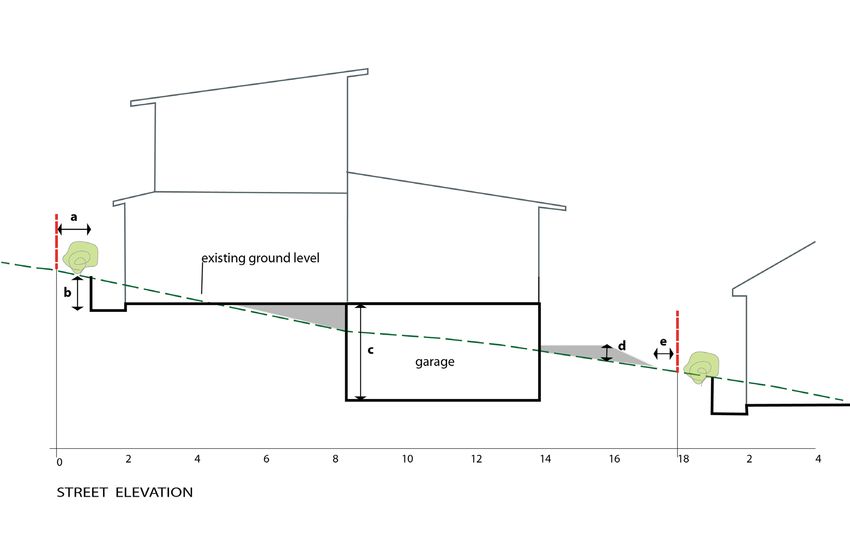
Figure 11 - Cut and fill for a dwelling .......................................................................................................... 50
LMCC DCP 2014 – Revision 24
Page 3 – F2014/01178
Adopted by Council 9 March 2020Part 3 – Development within Residential Zones
1 INTRODUCTION
Part 3 - Development within Residential Zones applies to all development in the R1 General Residential,
R2 Low Density Residential and R3 Medium Density Residential land use zones.
The R1 General Residential zone only applies to land at North Wallarah, which has a site specific Area Plan.
The North Wallarah Area Plan (in Part 12 of this DCP) contains most controls for development in this area.
For issues not covered in the North Wallarah Area Plan, the controls of Part 3 – Development within
Residential Zones apply to development in the R1 General Residential Zone.
This part is to be read in conjunction with Part 1 (Introduction) of LM DCP 2014, which outlines Council’s
general requirements for all developments and provides advice on the lodgement requirements for a
Development Application. Part 1 also contains requirements for when an application seeks to vary a
development control.
Additionally, controls for specific land uses may apply, depending on the type of development proposed.
These controls can be found within Part 9 - Specific Land Uses of this DCP. Furthermore, an Area Plan may
apply depending on the location of the development. Area Plans contain area specific controls that need to
be considered. They can be found in Parts 10 - Town Centre Area Plans, 11- Heritage Area Plans and 12 -
Precinct Area Plans of this DCP.
1.1 HOW TO USE THIS PLAN
LM DCP 2014 is the primary document used by Council’s development assessment staff to assess
development applications. Proponents of development will need to:
1. Determine the land use zone that applies to the development site (refer to LM LEP 2014);
2. Refer to the Parts of LM DCP 2014 that contain controls for the zone where the development is
proposed (Parts 2 to 8);
3. Check if specific land use provisions apply to the proposed development (Part 9); and
4. Check if an Area Plan applies to the proposed development site (Parts 10, 11 or 12).
The development controls contained within each part and section, seek to achieve desired land use,
conservation and/or built outcomes consistent with corresponding LM LEP 2014 zone objectives and aims in
each part of LM DCP 2014.
Each part of LM DCP 2014 is structured to promote a development process where the site and context
analysis informs the design of the development. Parts 2 to 8 of this DCP generally have the following main
headings:
• Introduction – provides information about the particular part of the DCP, how to use the DCP and
aims for development within the particular zone group.
• Context and Setting – outlines the site issues and environmental opportunities and constraints that
need to be addressed in the development application.
• Development Design – provides Council’s detailed design related requirements.
• Operational Requirements – provides Council’s detailed requirements associated with the
construction and ongoing operation of the development.
The detailed provisions of each subsection in each part of LM DCP 2014 are presented as follows:
• Objectives – state what outcomes LMCC is seeking new development to achieve along with
providing the intent behind the controls, and
• Controls – advise the requirements for achieving outcomes and the desired future character
identified by the aims and objectives.
Additionally, Parts 2 to 8 contain the specific aims that LM DCP 2014 seeks to achieve. Where specific
controls are not provided, the aims of each part will be used to provide direction for a merits based
assessment of a development application.
LMCC DCP 2014 – Revision 24
Page 4 – F2014/01178
Adopted by Council 9 March 2020Part 3 – Development within Residential Zones
For more information on how to use this document, refer to Part 1 – Introduction.
1.2 ADDITIONAL CONTROLS FOR SPECIFIC LAND USES
If the development application relates to any of the following land uses, additional specific development
controls must be considered in conjunction with controls in this part of the DCP. The detailed controls for
these uses can be found in Part 9 of this DCP. Where a conflict exists between the controls within this part
and a specific land use, the specific land use section prevails.
Attached Dwellings Multi Dwelling Housing
Bed and Breakfast / Farm Stay Accommodation Places of Public Worship
Dual Occupancy Residential Flat Buildings
Dwelling House in Rural and Environmental Housing on Small and Narrow Lots
Zones
Foreshore and Waterway Development Secondary Dwelling
Health Consulting Rooms
1.3 AIMS FOR DEVELOPMENT IN THE RESIDENTIAL ZONES
Where controls are not provided for a particular circumstance, the following aims will be used to provide
direction for a merits based assessment of a development application.
The aims of LM DCP 2014 for development in Residential Zones are:
1. To ensure development responds to the characteristics of the site and the qualities of the surrounding
urban environment, or the desired future character.
2. To support the principles of Ecologically Sustainable Development.
3. To inspire innovative design for all forms of development within the residential zones.
4. To ensure development does not have adverse impacts on residential amenity.
LMCC DCP 2014 – Revision 24
Page 5 – F2014/01178
Adopted by Council 9 March 2020Part 3 – Development within Residential Zones
2 CONTEXT AND SETTING
2.1 SITE ANALYSIS
Objectives
a. To encourage good site planning, built form and landscape outcomes informed by an
understanding of the site and its context.
b. To illustrate how a development responds to a site and its relationship with the locality.
c. To identify the opportunities and constraints of sites, and the prevailing characteristics of a locality.
Controls
1. A Site Analysis Plan must be submitted that identifies the existing conditions relating to the subject
site, and the surrounding land that may influence the design process.
2. The Site Analysis Plan must address:
i. All relevant items as set out in the Site Analysis Guidelines; and
ii. All relevant matters outlined below in section 2.2 to 2.20.
3. The Site Analysis Plan must provide a comprehensive view of the constraints and opportunities of
the development site that will guide the design process.
4. The development application must clearly show that the constraints and opportunities identified in
the Site analysis Plan have been used to inform and resolve the development design.
5. An electronic 3D block model must be submitted for any development that is three or more storeys,
or that has a Gross Floor Area of 2000m2 or more. The model must clearly show the scale and
form of the proposed development and its setting, from viewing points along the street, and from
public open space, waterways and other significant vantage points.
6. Council may require an electronic model for smaller developments on sites with potentially high
visual or physical impacts on the public realm.
Note: The detail of the Site Analysis Plan should be tailored to the site, and the complexity of the proposed
development.
2.2 SCENIC VALUES
The Landscape Settings and Significant Natural Landscape Features Maps identify the Landscape
Setting boundaries and the relevant Scenic Management Zone for each Landscape Setting. The maps are a
guide to the scenic quality associated with lands within the City of Lake Macquarie and are contained within
the Scenic Management Guidelines. The Scenic Management Guidelines provide supporting documentation
to this DCP.
Objectives
a. To ensure that the scenic values of the City are protected and enhanced.
b. To ensure that developments visible or adjoining the coastline, Lake Macquarie or ridgelines
maintain and enhance the scenic value of these features.
Controls
1. A landscape and visual impact assessment is required for development identified in Table 1 unless
specified by Council. A landscape and visual impact assessment must be prepared in accordance
with section 7.3 of the Scenic Management Guidelines.
LMCC DCP 2014 – Revision 24
Page 6 – F2014/01178
Adopted by Council 9 March 2020Part 3 – Development within Residential Zones
Table 1 - Development requiring a landscape and visual impact assessment
Type, category or impact of development:
• Any designated, SEPP 14 or SEPP 65 development
• Any new development or alterations and additions resulting in a building or structure equivalent to 4
storeys or more (in any zone), or a car park of 2 or more storeys (in any zone)
• Telecommunication towers
• Substantial loss of native tree cover (land parcels of one hectare or greater)
• Subdivisions (in any zone with 10 or more lots proposed)
• Tourist and visitor accommodation
• Removal of any tree on the Significant Tree Register
• Seniors living developments and hospitals with more than 30 beds
• Educational facilities (new facilities in residential zones)
• Any commercial buildings being more than 50 metres long on any side, or being over 10 metres
high
Location of development:
• Any development that is; within 300m of the Mean High Water Mark of the lake or coastal edge, or
on a ridgeline and involves two or more of the following:
o height equivalent to 3 or more storeys, or
o sloping site (10% or more), or
o requiring a combined cut and fill exceeding 2 metres, or
o a development footprint exceeding 2000m2.
• Any building or structure in a public reserve having a footprint exceeding 100m2 or being over 10
metres high.
• Any development on a heritage item and/or development within a heritage conservation area (apart
from alterations and additions to existing houses or new complying development houses)
• Any development within 300m of the Sydney-Newcastle Freeway (apart from alterations and
additions to existing houses or new complying development houses)
2. Developments must be designed and sited to complement their location through:
i. the retention of existing vegetation,
ii. incorporating appropriate landscaping,
iii. minimising cut and fill,
iv. building design and articulation compatible with natural context, and
v. colour and material selection.
3. For developments visible from the coastline, Lake Macquarie and adjacent waterways, or from
significant ridgelines, external finishes should be non-reflective and muted in tone.
2.3 GEOTECHNICAL
Objectives
a. To minimise potential damage to buildings/structures resulting from land movement.
LMCC DCP 2014 – Revision 24
Page 7 – F2014/01178
Adopted by Council 9 March 2020Part 3 – Development within Residential Zones
Controls
1. A geotechnical report prepared by a geotechnical engineer must accompany an application for
development within T1, T1A,T2, T2A, T3 and T3A areas, and within zones T4, T5 and T6 where
specified after a site inspection by Council. Council has discretion whether a geotechnical report is
required for the following minor structures and will consider site conditions and the size and
construction materials of the proposed structure:
• Garages,
• Carports,
• Decks and the like,
• Pergolas and the like,
• Fiberglass swimming pools, and
• Earthworks including excavation and / or fill not exceeding 1000mm in depth.
2. A geotechnical report prepared by a geotechnical engineer must accompany an application for
development within T5 and T6 areas where the proposed building is greater than 2500m 2 or where
the building is three or more storeys high.
3. In areas not covered by Council’s geotechnical area maps and where the slope of the land
exceeds 10%, Council may require a Slope Stability Assessment (subject to a site inspection by
Council staff).
Note: Where an application relies upon a geotechnical report prepared as part of a previous development
approval, a geotechnical engineer must endorse the plans submitted with the application to confirm that the
proposed development is consistent with the geotechnical report.
2.4 MINE SUBSIDENCE
Objectives
a. To minimise risks to buildings and structures associated with potential mine subsidence.
Controls
1. Where an application is made for the construction of a structure or building within a Mine
Subsidence District, written concurrence must be obtained from the Mine Subsidence Board.
Written concurrence should be obtained prior to the application being submitted to Council.
2. Written concurrence from the Mine Subsidence Board is not required for certain works that have
deemed approval under the Mine Subsidence Board’s publication ‘A Guide for Council Staff’.
Note: Please refer to the Mine Subsidence Board’s ‘Surface Development Guidelines’ for important
information.
2.5 CONTAMINATED LAND
Objectives:
a. To ensure that contaminated land is identified through appropriate investigations
b. To ensure that the contaminated site is appropriately and effectively remediated prior to occupation
of the land for its intended use.
c. To ensure that changes to land use will not increase the risks to public health or the environment
as a result of contamination on site, or on adjacent properties.
Controls:
1. Where development is proposed on land identified as being potentially contaminated, a
Preliminary Site Investigation Report must be prepared and submitted with the application for
development. Refer to Council's Policy for Managing Contaminated or Potentially Contaminated
Land within the City of Lake Macquarie for further information.
2. Where contaminants are found within the site, a Detailed Site Investigation Report must be
prepared and lodged with the development application. Alternatively, for properties within the
LMCC DCP 2014 – Revision 24
Page 8 – F2014/01178
Adopted by Council 9 March 2020Part 3 – Development within Residential Zones
Pasminco Lead Contamination Survey Grid, a Detailed Site Investigation Report is not required
where the parcel is assumed to be contaminated with lead oxide and/or Pasminco Black Slag.
3. For properties within the Pasminco Lead Contamination Survey Grid assumed to be contaminated
with lead oxide and/or Pasminco Black Slag, a standard Remedial Action Plan Template can be
completed and submitted with the application.
4. For properties contaminated with Black Slag that are not within the Pasminco Lead Contamination
Survey Grid area, a Standard Remedial Action Plan Template can be completed and submitted
with the application.
5. Where a Detailed Site Investigation Report identifies the need for remediation, a Remedial Action
Plan must be prepared and submitted prior to issue of a construction certificate.
6. The site must be validated as suitable for its intended use prior to the issue of an occupation
certificate.
Note: Council may request a formal audit of contamination documentation by a site auditor accredited with
the NSW Environment Protection Authority under the Contaminated Land Management Act 1997.
Note: Refer to SEPP 55 and the NSW State Government’s ‘Managing Land Contamination: Planning
Guidelines’ for more information.
2.6 ACID SULFATE SOILS
Objectives
a. To ensure that disturbance of Acid Sulfate Soils or Potential Acid Sulfate Soils is minimised, to
prevent adverse environmental impacts on soil conditions.
b. To ensure that water quality and associated receiving waters are not adversely affected Acid
Sulfate Soils.
c. To ensure that habitat is not adversely affected by Acid Sulfate Soils.
d. To ensure that built structures and infrastructure are not adversely affected by Acid Sulfate Soils.
Controls
1. Development must be sited or designed to avoid the disturbance of Acid Sulfate Soils or potential
Acid Sulfate Soils.
2. Where the disturbance of Acid Sulfate Soils is unavoidable, a Preliminary Acid Sulfate Soil
Assessment report must be submitted with the development application, in accordance with the
NSW Acid Sulfate Soils Planning Manual.
3. Where a Preliminary Acid Sulfate Soil Assessment report identifies potential adverse impacts, a
detailed assessment report and management plan must be submitted, in accordance with the NSW
Acid Sulfate Soils Planning Manual.
4. Any Acid Sulfate Soils must be identified on the site analysis plan.
Note: Refer to Lake Macquarie Council’s Acid Sulfate Soil planning maps showing classes of land
containing potential or actual Acid Sulfate Soils. These maps are available at Council’s Customer Service
Centre, Speers Point.
2.7 STORMWATER MANAGEMENT
Objectives
a. To ensure that development does not adversely affect water quality or availability, including ground
water.
b. To ensure that watercourses and associated riparian vegetation are maintained so as to contribute
to water quality, and to mitigate sedimentation of the Lake Macquarie waterway.
c. To minimise any adverse impacts on downstream built or natural environments, or on nearby land
due to increased development.
LMCC DCP 2014 – Revision 24
Page 9 – F2014/01178
Adopted by Council 9 March 2020Part 3 – Development within Residential Zones
d. To incorporate Water Sensitive Urban Design techniques into all new developments.
e. To minimise the volume and rate of stormwater leaving a development site.
Controls
1. A Water Cycle Management Plan must be submitted for all development except single dwelling
houses and dual-occupancy developments. The Water Cycle Management Plan must provide
details of the management of stormwater, and the measures proposed to mitigate the effects of
stormwater on adjoining or downstream sites in accordance with Council’s Water Cycle
Management Guidelines.
2. A Site Stormwater Drainage Plan must be submitted for all single dwelling houses and dual-
occupancy development proposals. The Site Stormwater Drainage Plan must be prepared in
accordance with Council’s Water Cycle Management Guidelines.
3. On-site measures must be implemented to maintain water quality, and to minimise the volume of
stormwater run-off and the rate at which stormwater leaves the site.
4. A maximum of 10% of run-off from built impermeable surfaces may be discharged directly to the
drainage system. The remaining 90% of run-off must be captured for reuse, or managed through
infiltration and retention measures prior to being discharged to the drainage system.
5. Stormwater management systems should be visually unobtrusive and integrated within site
landscaping, car parks or building structures.
6. All developments (except dwelling house or dual occupancy) that involve the re-use of stormwater
or the use of recycled water must demonstrate compliance with the Australian Guidelines for
Water Recycling and the licensing requirements of the Water industry Competition Act 2006.
7. Stormwater management systems must be designed in accordance with the Water Cycle
Management Guidelines.
2.8 CATCHMENT FLOOD MANAGEMENT
This section applies to land in the various creek catchments in Lake Macquarie that are shown as ‘Lots
Affected by Catchment Flooding controls’ on Council’s ‘Flood Control Lots’ map.
The map is indicative only and property information should be checked to confirm if a lot is a catchment flood
control lot.
Some lots are affected by both catchment flooding and Lake flooding. The development controls that apply
to these lots depend on the type of development, and further advice should be sought from Council.
Further information on flood risk and flood planning levels (floor levels) for particular lots can be obtained by
applying for a Flood Certificate from Council.
Provisions regarding Lake flooding are contained in section 2.9 of this Part of DCP 2014.
Where inconsistencies arise, the controls in area plans prevail over controls in parts 2 to 9 of this DCP.
Objectives
a. To ensure that development is sited and designed to minimise potentially adverse impacts of
flooding on the proposed development, or on other properties.
b. To ensure that measures are implemented to reduce the impact of flooding and flood liability on
owners and occupiers of flood prone property. Such measures must also reduce private and public
losses resulting from flooding, and manage risks to property and life from flood events.
Controls
1. Development must be consistent with the current version of the NSW Floodplain Development
Manual, and any relevant local flood study, floodplain management study or plan applying to the land
that has been endorsed by Council.
2. The proposed development must consider and respond to flooding hazards. It must also mitigate
risks to life and/or property through design and positioning of development.
LMCC DCP 2014 – Revision 24
Page 10 – F2014/01178
Adopted by Council 9 March 2020Part 3 – Development within Residential Zones
3. Buildings must not be located in an identified floodway.
4. Buildings and other structures, including fences, must be designed so as not to impede the flow of
floodwaters or entrap debris.
5. Habitable rooms must have a finished floor height at least 500mm above the 100 year probable ARI
(1% AEP) event. Where probability flood levels are not available, habitable rooms must have a
finished floor height at least 500mm above the highest observed flood level for the development site.
6. Non-habitable rooms must have a finished floor height at or above the 20 year probable ARI (5%
AEP) event. Where probability flood levels are not available, non-habitable rooms must have a
finished floor height at or above the highest observed flood level for the site, except where this would
result in a floor level more than 500mm above the existing ground level. In this case, a floor level of
at least 500mm above existing ground level must be achieved.
7. Fill is not permitted within core riparian zones, within the Lakefront Development Area or the
Foreshore Development Area, or within the extent of the 100 year probable ARI (1% AEP) flood
event.
8. Lesser provisions may be acceptable where the applicant can demonstrate that the type of
development or the proposed use poses no significant risk to life or property by flooding.
9. Any use of fill associated with development must not substantially impede the flow of floodwater, and
must not contribute to flooding or ponding of water on any other property.
10. Additions or alterations to existing development will be assessed on the merits of the situation,
having regard to meeting an acceptable level of risk of flood damage.
11. Development on designated flood prone land must incorporate the floodplain risk management
measures, as recommended by a local flood study, floodplain management study or plan, which
identifies and addresses appropriate actions in the event of flooding.
12. Development on land subject to flooding must use flood compatible materials that will minimise
damage by flooding.
13. Development on lots adjoining areas affected by a 100 year probable ARI event will be subject to
floor height requirements, even when the site may not be subject to flooding from the 100 year
probable ARI event. This requirement is not applicable for land higher than 500mm above the 100
year probable ARI, as calculated for the relevant site.
14. Development where 100 year probable ARI levels are not available, and which could be flood liable,
must be designed to meet an acceptable level of risk from flood damage. This may require the
preparation of a Local Flood Study that considers cumulative impact issues, and demonstrates
negligible impacts on other lands.
Note: Refer to Council’s Flood Management Guideline for further information on the NSW Floodplain
Development Manual, completed floodplain management plans, and on Council’s requirements for flood
studies.
Table 2 - Flood Planning Levels and floor height requirements in areas affected by catchment flooding and covered by a
Floodplain Management Study and Plan
Development Type (including extensions) Minimum Height Requirements
Dwellings
Habitable rooms 1 in 100 year probable flood level + 500mm
freeboard (post and beam rather than slab on
ground preferred)
Non-habitable rooms and garages 1 in 20 year probable flood level
Carports, boat sheds, garden sheds, and other No requirement
ancillary structures (excluding garages)
Unsealed electrical installations 1 in 100 year probable flood level + 500mm
LMCC DCP 2014 – Revision 24
Page 11 – F2014/01178
Adopted by Council 9 March 2020Part 3 – Development within Residential Zones
Development Type (including extensions) Minimum Height Requirements
freeboard
Medium and High density residential development
Habitable rooms 1 in 100 year probable flood level + 500mm
freeboard
Non-habitable rooms and garages 1 in 20 year probable flood level
Carports, boat sheds, garden sheds, and other No requirement
ancillary structures (excluding garages)
Basement car parking Constructed to preclude entry of floodwater at
levels up to the 1 in 100 year probable flood level
+ 500mm freeboard. Additional requirement for
basement levels to implement a failsafe means of
evacuation, and a pump-out
Unsealed electrical installations 1 in 100 year probable flood level + 500mm
freeboard
Commercial and Retail
Internal floor height 1 in 100 year probable flood level + 500mm
freeboard
Basement car parking Constructed to preclude entry of floodwater at
levels up to the 1 in 100 year probable flood level
+ 500mm freeboard. Additional requirement for
basement levels to implement a failsafe means of
evacuation, and a pump-out system to remove
flood waters.
Unsealed electrical installations 1 in 100 year probable flood level + 500mm
freeboard
Sensitive Uses (Residential care facilities, hospitals, etc.)
Internal floor height Probable maximum flood level
Unsealed electrical installations Probable maximum flood level
2.9 LAKE FLOODING AND TIDAL INUNDATION (INCORPORATING SEA LEVEL RISE)
This section applies to land on and near the Lake Macquarie foreshore that is shown as ‘Lots Affected by
Lake Flooding controls’ on Council’s ‘Flood Control Lots’ map. The map is indicative only and property
information should be checked to confirm if a lot is a Lake flood control lot.
Some lots are affected by both catchment flooding and lake flooding. The development controls that apply to
these lots depend on the type of development, and further advice should be sought from Council.
LMCC DCP 2014 – Revision 24
Page 12 – F2014/01178
Adopted by Council 9 March 2020Part 3 – Development within Residential Zones
Provisions regarding Catchment Flooding are contained in section 2.8 of this Part of DCP 2014.
The floor height requirements in Table 3 below must only be used for development on lots shown as ‘Lots
Affected by Lake Flooding controls’ on Council’s ‘Flood Control Lots’ map.
Council completed the Lake Macquarie Waterway Flood Study and Risk Management Plan in 2012. This
flood study and risk management plan incorporated the implications of predicted sea level rise.
Predicted sea level rise is based on expert advice from NSW Government agencies and expert scientific
agencies, namely that projections of sea level rise along the NSW coast are for a rise relative to 1990 mean
sea levels of 40cm by 2050 and 90cm by 2100.
The controls contained in this section prevail where there is an inconsistency with other development
requirements. This is particularly relevant to cut and fill controls.
Objectives
a. To ensure that development is sited and designed to minimise potentially adverse impacts of
flooding on the proposed development, or on other properties.
b. To ensure that measures are implemented to reduce the impact of flooding and flood liability on
owners and occupiers of flood prone property. Such measures must also reduce private and public
losses resulting from flooding, and manage risks to property and life from flood events.
c. To ensure that development adequately considers and responds to sea level rise projections, and
the predicted effects on inundation, flooding, coastal and foreshore recession, and on groundwater
levels.
d. To ensure that development on land vulnerable to sea level rise is situated and designed to
minimise the risk from future inundation, flooding, coastal and foreshore recession, and from rises
in groundwater levels during the expected life of the development.
e. To ensure that development is designed to enable future adaptation if projections are realised, or
that measures are implemented to mitigate any adverse impacts of climate change or sea level
rise.
f. To encourage innovative responses to sea level rise impacts.
Controls
1. Development must implement measures to mitigate the adverse effects of projected sea level rise
and increases in flood levels on the development.
2. Development should be designed and situated to reduce the risk from the effects of sea level rise.
For example, structures should be located on the highest part of the Lot and/or located on the Lot
as far back from the foreshore or coastline as possible, while still meeting other controls and
objectives of the DCP.
3. Development should not be located in areas predicted to be permanently inundated during the life
of the asset. The assumed asset life is 100 years for residential care facilities and seniors housing,
hospitals, mixed use development, as well as medium and high density housing, and 50 years for
other developments.
4. Notwithstanding the provisions for Cut and Fill in section 3.26, special consideration may be given
to increased fill allowances in areas affected by sea level rise provided that:
i. Additional fill does not adversely affect stormwater management, drainage, or the flow of
water from roads, natural or constructed watercourses, foreshore areas, or adjoining
properties.
ii. The filled area maintains functional connections to adjoining footpaths, roads, neighbouring
blocks, and other local features.
5. Development identified within Table 3 should comply with the floor height provisions. Where the
development proposed is not contained within Table 3, or an alternative to the provisions contained
within Table 3 is proposed, a Flood Safety Audit and Management Plan must be submitted with the
application, which is to include:
i. Current 100 year ARI flood levels and velocity, as well as 2050 and 2100,
LMCC DCP 2014 – Revision 24
Page 13 – F2014/01178
Adopted by Council 9 March 2020Part 3 – Development within Residential Zones
ii. Analysis of potential and likely risk of flooding, and/or potential threat to life and/or property,
now and at 2050 and 2100,
iii. Analysis of the potential effects of permanent inundation, foreshore recession and rising
groundwater,
iv. Where flood proof materials are proposed, evidence of flood-proof characteristics of those
materials is to be provided,
v. Where an innovative of adaptable building design is proposed, it meets the principles and
performance criteria set out in the Development Guidelines for Resilient Housing for Lake
Macquarie, and
vi. Any other justification for an alternative adaptive measure to be implemented.
6. The assessing officer may determine that the development proposal is of a minor nature and there
is no need for a Flood Safety Audit and Management Plan. In these circumstances, the assessing
officer still needs to be satisfied that the proposed development adequately addresses projected
sea level rise and increases in flood levels.
Table 3 - Floor height requirements for land affected by Lake Flooding and Tidal Inundation requirements.
Development Type (including Minimum Floor Height Actual Minimum Floor
extensions) Requirements Level for Land to which the
Lake Flood Study Applies
Dwellings
Habitable rooms 1 in 100 year probable flood level 2.36 m AHD
for 2050 + 500mm freeboard (post
and beam rather than slab on
ground preferred)
Non-habitable rooms 1 in 20 year probable flood level for 1.61 m AHD
and garages 2050
Carports, boat sheds, No requirement
garden sheds, and other
ancillary structures
(excluding garages)
Unsealed electrical 1 in 100 year probable flood level 2.36 m AHD
installations for 2050 + 500mm freeboard
Medium and High density
residential development
Habitable rooms 1 in 100 year probable flood level 2.82 m AHD
for 2100 + 500mm freeboard
Non-habitable rooms 1 in 20 year probable flood level for 2.10 m AHD
and garages 2100
Carports, boat sheds, No requirement
garden sheds, and other
ancillary structures
(excluding garages)
Basement car parking Constructed to preclude entry of 2.82 m AHD
floodwater at levels up to the 1 in
100 year probable flood level for
2100 + 500mm freeboard.
Additional requirement for
basement levels to implement a
failsafe means of evacuation, and a
LMCC DCP 2014 – Revision 24
Page 14 – F2014/01178
Adopted by Council 9 March 2020Part 3 – Development within Residential Zones
Development Type (including Minimum Floor Height Actual Minimum Floor
extensions) Requirements Level for Land to which the
Lake Flood Study Applies
pump-out system to remove flood
waters.
Unsealed electrical 1 in 100 year probable flood level 2.82 m AHD
installations for 2100 + 500mm freeboard
Sensitive Uses Probable maximum flood level for 3.27 m AHD
(Residential care facilities, 2100
hospitals, etc.)
Unsealed electrical Probable maximum flood level for 3.27 m AHD
installations 2100
2.10 NATURAL WATER SYSTEMS
Definition
A natural water system is a naturally occurring watercourse, waterway, lake, wetland, lagoon, estuary
and/or other water body.
Objectives
a. To protect and maintain the water regime of natural water systems.
b. To ensure that development does not adversely affect aquatic fauna.
c. To ensure that development does not adversely affect water quality or availability, including ground
water.
d. To ensure that watercourses and associated riparian vegetation are maintained to contribute to
water quality and to mitigate sedimentation of the Lake Macquarie waterway.
e. To ensure that natural water systems and associated vegetation and landforms are protected to
improve the ecological processes and ensure that land is adequately buffered from development.
f. To ensure that the pre-development water quality of receiving waters is maintained or improved.
Controls
1. Natural water systems should be maintained in a natural state including maintaining riparian
vegetation and habitat such as fallen debris. Unless extraordinary circumstances exist, filling,
redirecting, piping, capping or otherwise modifying natural water systems will not be permitted.
Refer to Council’s Water Cycle Management Guidelines for further information.
2. Where a development is associated with, or will affect a natural water system, rehabilitation must
occur to return that natural water system – as much as possible – to a natural state. The
Rehabilitation Plan must be prepared in accordance with Council’s Guidelines for the Preparation
of Rehabilitation Plans for Degraded Watercourses or Waterbodies.
3. Rehabilitation should occur where a development site includes a degraded watercourse, water
body, or wetland. Rehabilitation is to be carried out following the completion of a Rehabilitation
Plan, This Plan must prepared in accordance with Council’s Guidelines for the Preparation of
Rehabilitation Plans for Degraded Watercourses or Waterbodies.
4. Stormwater must be managed to minimise nutrient and sediment runoff entering constructed
drainage lines, natural watercourses, or waterways.
5. Development within a Vegetated Riparian Zone (VRZ) (as shown in Figure 1 – Vegetated Riparian
Zones) should be avoided where possible to retain its ecological processes. Where development
is unavoidable within the VRZ, it must be demonstrated that potential impacts on water quality,
aquatic habitat and riparian vegetation will be negligible.
LMCC DCP 2014 – Revision 24
Page 15 – F2014/01178
Adopted by Council 9 March 2020Part 3 – Development within Residential Zones
6. A Plan of Management must be submitted in accordance with State Government guidelines for
development proposed within a VRZ.
7. Asset Protection Zones must not be located within the Vegetated Riparian Zone.
Img_238
Figure 1 - Vegetated Riparian Zones
Types of watercourses VRZ Width2 Total Riparian
(Each side of Corridor Width
watercourse)
Any first order1 watercourse 20m + channel
10 metres
width
40m + channel
width
Any second order1 watercourse
20 metres
60m + channel
Any third order1 watercourse 30 metres
width
80m + channel
Any fourth order1 watercourse or greater (includes estuaries, 40 metres
width
wetlands and any parts of rivers influenced by tidal waters)
1 As classified under the Strahler System of ordering watercourses.
2 Bushfire Asset Protection zones will not be permitted in the Vegetated Riparian Zone. Additional areas may need to
be protected to support ecological processes.
2.11 BUSHFIRE
This section only applies to land identified on Council’s Bushfire Prone Land Map.
Objectives
a. To ensure that risks associated with bushfire are appropriately and effectively managed on the
development site.
b. To ensure that bushfire risk is managed in connection with the preservation of the ecological values
of the site and adjoining lands.
Controls
1. Development must comply with the NSW Planning for Bushfire Protection Guidelines
LMCC DCP 2014 – Revision 24
Page 16 – F2014/01178
Adopted by Council 9 March 2020Part 3 – Development within Residential Zones
2. Asset Protection Zones must:
i. Be incorporated into the design of the development;
ii. Be as low maintenance as possible;
iii. Be located outside areas of ecological value and the buffers necessary to protect them; and
iv. Not occur on adjoining environmental zoned land.
3. Bushfire prone areas and Asset Protection Zones must be identified on the Site Analysis Plan.
Refer to Council’s Bushfire Prone Land Map.
4. Clearing for the purposes of Asset Protection Zones should be avoided on ridgelines and slopes of
1:5 or greater.
5. Clearing of vegetation must be limited to that necessary to meet the NSW Planning for Bushfire
Protection Guidelines.
6. Clearing of native vegetation or trees for the purposes of reducing bushfire risk must be consistent
with the current Bushfire Risk Management Plan prepared under the Rural Fires Act 1997.
Note: Development Consent is not required for clearing for the purpose of bushfire hazard reduction if the
clearing is consistent with the current Bushfire Risk Management Plan, and is undertaken in accordance with
a current hazard reduction certificate issued by the Rural Fire Service or other certifying authority.
2.12 FLORA AND FAUNA
Objectives
a. To avoid and minimise impacts on native flora and fauna.
b. To protect and enhance significant flora and fauna, vegetation communities, and significant habitat
on the site and surrounding development sites.
c. To protect and enhance ecological corridors and increase the connections between habitats.
d. To ensure rehabilitation of degraded areas.
Controls
1. Where the proposed development is likely to have an impact on native vegetation or fauna habitat,
or where five or more native trees are proposed to be removed, a flora and fauna assessment
must be submitted with the development application. The flora and fauna assessment must be
prepared in accordance with Council’s Flora and Fauna Survey Guidelines.
2. The flora and fauna assessment must be sufficient to adequately identify and assess all the
impacts of the proposed development. This includes cumulative, direct and indirect impacts, as
well as the impacts of Asset Protection Zones, provision of services (water and sewer, etc) and
stormwater management.
3. Where a proposed development site is within a vegetation corridor identified on Council’s Native
Vegetation and Corridors Map, or identified as part of a site specific flora and fauna assessment,
the corridor must be surveyed. Within the survey, the appropriate corridor width must be
determined with reference to core habitat areas and potential edge effects and fragmentation.
The proposed development should be located and designed to avoid impacts on the identified
vegetation corridor. Where this is not possible, the development should be designed to minimise
impacts.
4. Development should be designed to avoid impacts on native flora and fauna, and minimise any
unavoidable impacts. Significant flora and fauna species, vegetation communities and habitat
should be protected and enhanced through appropriate site planning, design and construction.
5. A Site Vegetation Plan must be submitted clearly indicating the location of the proposed
development in relation to vegetation communities, significant flora and fauna species and
vegetation, and significant habitat and corridors on the site.
6. Native vegetation buffers must be provided between development and areas containing
threatened flora and fauna species or their habitat, threatened vegetation communities and native
vegetation corridors. The width of the buffer should be determined with reference to the function
LMCC DCP 2014 – Revision 24
Page 17 – F2014/01178
Adopted by Council 9 March 2020Part 3 – Development within Residential Zones
of the habitat, the threat of sea level rise and the type of development proposed. The buffer
should be designed to keep the area of significance in natural condition.
7. A suitable barrier such as a perimeter road should be provided between development, (including
landscaped areas) and native vegetation or significant habitat features, to minimise edge effects
8. Where a proposed development is likely to impact on an area of native vegetation, it must be
demonstrated that no reasonable alternative is available. Suitable ameliorative measures must
also be proposed (eg: weed management, rehabilitation, nest boxes).
9. Rehabilitation of degraded areas of the development site should include local native species to
establish a self-maintaining ecosystem as close as possible to the natural state.
10. Buildings and structures, roads, driveways, fences, dams, infrastructure, drainage and asset
protection zones should be located outside of areas with significant flora and fauna, native
vegetation corridors and buffers.
11. An application for removal of native vegetation will only be considered where it is ancillary to, and
necessary for conducting an approved use of the land (ie: an application for clearing alone will not
be supported).
12. Where retention or rehabilitation of native vegetation and/or habitat is required, a vegetation
management plan must be prepared in accordance with Council’s Vegetation Management Plan
Guidelines. This must detail how vegetation will be protected, rehabilitated and managed before,
during and after construction.
13. Long-term protection and management of areas set aside for ecological reasons is encouraged
through secure tenure with appropriate conservation management. This may be achieved through
a Planning Agreement.
14. Development should be consistent with the effective conservation of land within any adjacent
Environmental or Waterway zone and its protection from adverse impacts. It should include, but
not be limited to weed invasion, erosion and sedimentation, pollution, chemicals, nutrients,
stormwater run-off, feral and domestic animals.
Note: Council may require a bond to ensure that native vegetation is protected and any ameliorative
measures are undertaken.
2.13 PRESERVATION OF TREES AND VEGETATION
Objectives
a. To ensure that trees listed on Council’s Significant Tree register are not adversely affected by
development.
b. To maintain and enhance the natural bushland or treed character of the City.
c. To retain trees for the urban amenity, microclimate, scenic, air and water quality, and the social
benefits that they provide.
Controls
1. For the purposes of Clause 5.9 in LMLEP 2014, development consent is required to ring bark, cut
down, top, lop, remove, injure, wilfully destroy or clear:
i. Any species of vegetation that existed in the State of New South Wales before European
Settlement;
ii. A tree which is listed in Council’s Significant Tree Register;
iii. Tree(s) or native vegetation listed as heritage items or located within a Heritage
Conservation Area; or
iv. A Norfolk Island Pine Tree (Araucaria heterophylla) that is greater than three metres in
height, or that has a trunk diameter of 75mm or greater, measured at ground level.
Note: This clause includes Native Vegetation defined in the Native Vegetation Act 2003 and marine
vegetation covered by section 205 of the Fisheries Management Act 1994.
LMCC DCP 2014 – Revision 24
Page 18 – F2014/01178
Adopted by Council 9 March 2020Part 3 – Development within Residential Zones
2. Except in the E2 Zone, development consent is not required to remove, injure, wilfully destroy or
clear native vegetation (excluding native trees and shrubs over three metres in height), only if:
i. The work is for the purpose of landscaping understorey vegetation and lawn areas where the
area to be cleared is less than 600m² (in total), and is on the same allotment as, and within
the curtilage of an approved dwelling;
ii. The soil surface exposed in any period of 90 consecutive days is less than 250m 2;
iii. The slope of the land is less than 15 degrees;
iv. The area is not subject to a development consent that requires the native vegetation to be
retained; and
v. The work does not involve the disturbance of habitat for threatened species.
3. Development consent is not required to ring bark, cut down top, lop, remove, injure, wilfully destroy
or clear a tree or native vegetation, if:
i. The tree is not listed on Council’s Significant Tree Register or as Heritage Item or is located
within a heritage conservation area, and
ii. The tree or native vegetation is not required to be retained by a development consent, and
iii. The tree or native vegetation is within five metres of the outermost projection of a lawfully
used building (that is not exempt or complying development) and is on the same allotment as
the building, or
iv. The tree or native vegetation is within one metre of a sealed driveway to a lawfully used
building (that is not exempt or complying development) and is on the same allotment as the
building, or
v. The tree or native vegetation is within five metres of the outermost projection of a lawfully
used building (that is not exempt or complying development) on an adjoining allotment and
the building and owners of both properties reach a written agreement that is submitted to
Council prior to removal.
Note: For the purposes of clause 3 the distance must be measured from the trunk of a tree or shrub
measured at ground level to the outer most projection of the building.
Note: A sealed driveway is a driveway or car park with an impervious surface such as concrete, pavers, or
bitumen. A gravel driveway is not classed as a sealed driveway.
Note: A lawfully used building does not include drainage, excavation, a garden shed or jetty, but does
include an underground water storage structure, septic tank or swimming pool.
4. Development consent is not required for removal of a tree or native vegetation if Council is satisfied
beforehand that the tree or native vegetation:
i. Is dead and is not required as habitat for native fauna or
ii. Is a risk to life or property.
Note: Evidence to support removal should be forwarded to Council in accordance with requirements
outlined in Council's Tree Preservation and Native Vegetation Management Guidelines. Council's Tree
Assessment Officer may undertake a site inspection to verify that these conditions are satisfied.
Note: Habitat required for native fauna includes native vegetation and trees (including dead or dying trees)
support hollows, spouts, splits, nests and roosts.
5. Development consent is not required for removal of a tree or native vegetation if:
i. The tree or native vegetation is in danger of imminent failure and there is risk to life or
property; and
ii. The tree is not listed on Council’s Significant Tree Register or as Heritage Item or is located
within a heritage conservation area, and
iii. Evidence to support its removal is forwarded to Council following the removal, in accordance
with Council’s Tree Preservation and Native Vegetation Management Guidelines.
6. Development consent is not required for removal of a NSW native tree if the tree is:
LMCC DCP 2014 – Revision 24
Page 19 – F2014/01178
Adopted by Council 9 March 2020You can also read