Draft plan September 2021 - Kingston City Council
←
→
Page content transcription
If your browser does not render page correctly, please read the page content below
Draft plan September 2021
Acknowledgement from Bunurong Land
Council

                                     Council foreword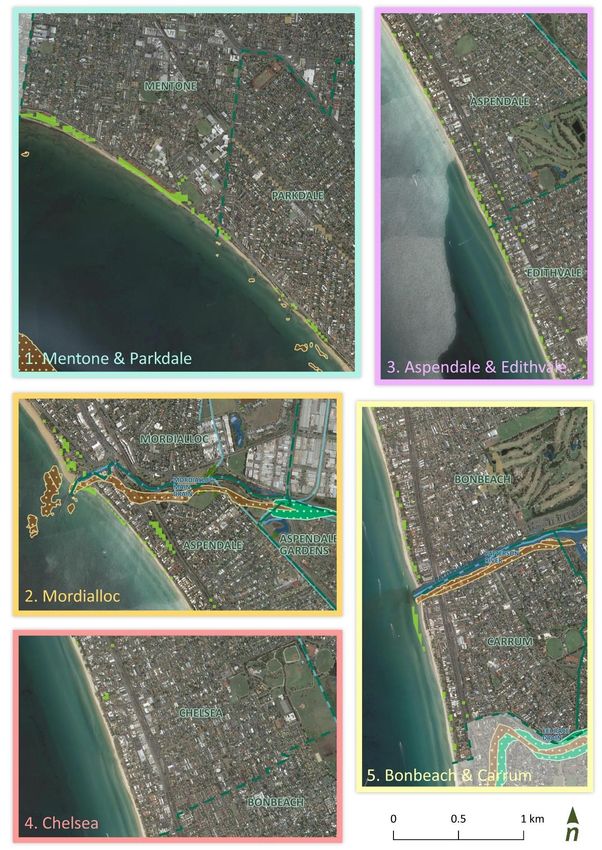
Document history

Revision:
   Revision no.   02
   Author/s       P. Bicknell
                  P. Richards
                  S. Doumstis
                  E. Hodson
   Checked        A.Shipp
   Approved       P.Bicknell

Distribution:
   Revision no.   02e
   Issue date     17/09/21
   Issued to      B. Lewis
   Description:   Draft plan

   Revision no.   01
   Issue date     08/07/21
   Issued to      B. Lewis
   Description:   Preliminary draft plan

Citation:
Please cite as:   Draft for comment – Do not cite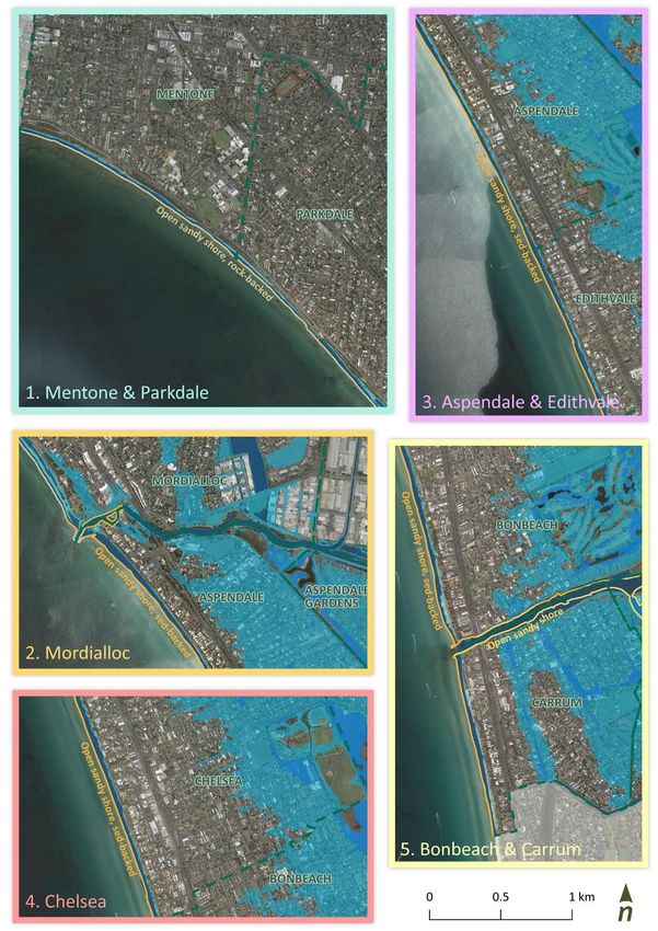
Contents
1 Introduction 6 Attachment A: Engagement approach 63
1.1 Strategic context 7 Attachment B: Statutory context for Kingston’s
1.2 State policy context 8 marine and coastal management 67
1.3 CMMP framework 10
Figures
2 Kingston 12
Figure 1. Timeline for developing the CMMP – currently at
2.1 Background 12 Draft CMMP. 7
The first custodians 12 Figure 2. The Planning and Decision Pathway sets out how
Present day management 12 the guiding principles and policy must be
considered in decision making (Source: DELWP
2.2 Local government area 16 2020). 8
Community 16 Figure 3. Long-term objectives for CMMP. 11
Industry and development 16
Figure 4. Public land management arrangements along
Land use 16 the City of Kingston coastline. 14
Transport and connectivity 16 Figure 5. Areas of Cultural Heritage Sensitivity. 22
2.3 Environmental setting 17 Figure 6. Ecosystems, habitats. 25
Landscapes and seascapes 17 Figure 7. Coastal infrastructure. 28
Coastal processes 17 Figure 8. Available coastal hazard overlays. 30
Changing climate for Kingston’s coast 18 Figure 9. Transport infrastructure. 34
Coastal and marine management 19 Figure 10. Kingston Planning Scheme. 36
3 Values, concerns and opportunities 20 Figure 11. Recreational infrastructure and areas. 38
Figure 12. Kingston CMMP program logic. 41
Objective 1: Acknowledge and act on our Traditional
Figure 13. CMMP goals - What we want to achieve for our
Owners’ rights, aspirations & knowledge 21
coast. 42
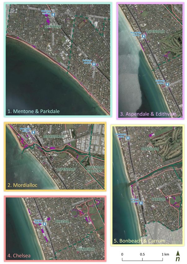
Objective 2: Protect and enhance the environment, Figure 14. Precinct 1 - Mentone and Parkdale, with
from our catchments through to the Bay 24 precinct actions shown on map. 48
Objective 3: Respect the natural environment and Figure 15. Precinct 2 - Mordialloc, with precinct actions
proactively strengthen our resilience to a shown on map. 50
changing climate 27 Figure 16. Precinct 3 – Aspendale and Edithvale, with
precinct actions shown on map. 52
Objective 4: Promote wise and sustainable use of our
Figure 17. Precinct 4 – Chelsea, with precinct actions
coastal and marine areas, to enjoy now and into
shown on map. 54
the future 32
Figure 18. Precinct 5 – Bonbeach and Carrum, with
Objective 5: Engage, enable and collaborate with our precinct actions shown on map. 56
community in the care of our coastline 40 Figure 19. CMMP implementation and adaptive
management framework. 59
4 Our management approach 41
4.1 CMMP framework 41
Our goals 41
Tables
Our actions 43 Table 1. Victoria’s marine and coastal policy context. 7
Table 2. Land managers and other key stakeholders. 13
4.2 Council-wide actions 44
Table 3. Priority and costing scale. 43
4.3 Precinct actions 47 Table 4. Council-wide actions for the Kingston CMMP. 44
Table 5. Key engagement activities and events to date. 64
5 Implementation 59
6 References 61
Kingston Coastal and Marine Management Plan 3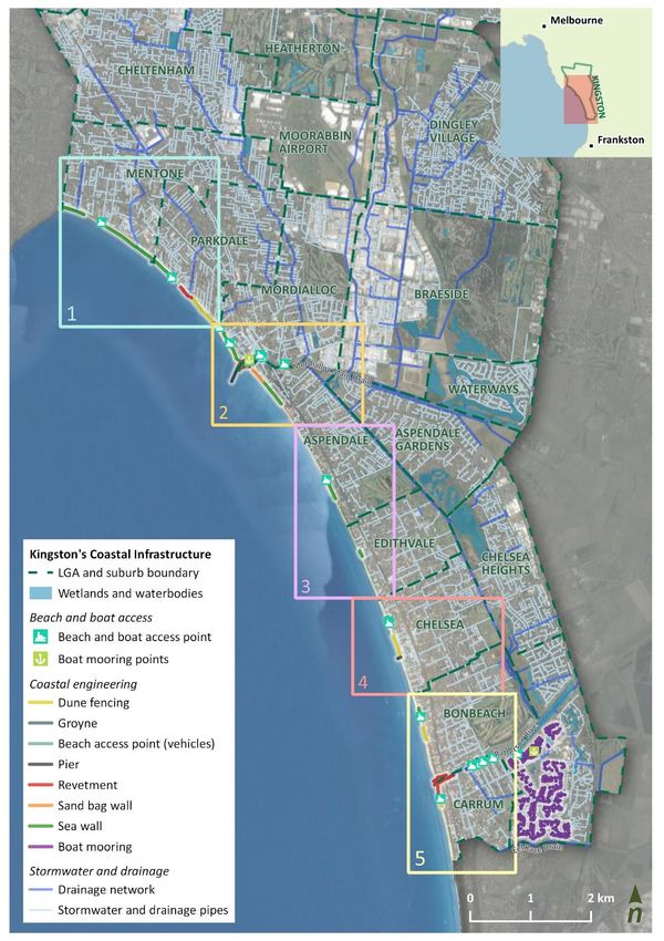
Glossary
 ABM              Association of Bayside Municipalities
 AEP              Annual exceedance probability
 BBV              Better Boating Victoria
 BLCAC            Bunurong Land Council Aboriginal Corporation
 C&EP             Communication and Engagement Plan
 CMMP             Coastal and Marine Management Plan
 DELWP            Department of Environment, Land, Water and Planning
 EPA              Environment Protection Authority Victoria
 EV               Electric Vehicle
 EVCs             Ecological Vegetation Classes
 GPTs             Gross Pollutant Traps
 IPCC             Intergovernmental Panel on Climate Change
 LGA              Local Government Area
 LSV              Life Saving Victoria
 LXRA             Level Crossing Removal Authority
 LXRP             Level Crossing Removal Project
 MAC              Marine and Coastal
 MER              Monitoring, Evaluation and Review
 MSV              Maritime Safety Victoria
 MW               Melbourne Water
 PPBCHA           Port Phillip Bay Coastal Hazard Assessment
 PV               Parks Victoria
 RAP              Registered Aboriginal Party
 SLR              Sel level rise
 VMCC             Victorian Marine and Coastal Council
 Vic WPS          Victorian Water Police Squad
 WSUD             Water Sensitive Urban Design

Kingston Coastal and Marine Management Plan                             4
Kingston Coastal and Marine Management Plan 5
1     Introduction

Kingston’s coastline is an iconic part of Port Phillip Bay. Combining continuous sandy beaches,
vegetated dune systems, access to the water and stunning bay views, our coastal and marine areas
attract locals and visitors all year around. Our foreshore provides a wide range of recreational,
economic and lifestyle opportunities. These are supported by facilities, infrastructure and
management initiatives that maintain our open space, preserve areas of cultural importance and
protect and enhance our sensitive and unique environments.

This Coastal and Marine Management Plan will help guide appropriate and effective management of
our marine and coastal areas. With increasing pressures from development and growth, a changing
climate and aging and inadequate infrastructure, a range of initiatives are needed to appropriately
balance the management of social, cultural, environmental, and economic values of our coastline and
the bay, ensuring it remains a desirable place to live, work and visit.

The City of Kingston (Council) require a strategic approach to help manage their coastal and marine areas. This draft
Coastal and Marine Management Plan (CMMP) has been created in consultation with the Kingston community, the
Bunurong Traditional Owners, Council staff and other agencies. It has been structured to align closely with legislation,
guidelines and government policy.

The draft CMMP presents:

       •    a vision and objectives reflecting community and stakeholder sentiment, and aligns with legislative direction

       •    the values and future aspirations for Kingston’s coastal and marine areas

       •    current and emerging issues, including those which may potentially threaten values

       •    potential opportunities, priority actions and projects for delivery, over the next 5-10 years

       •    an implementation pathway and monitoring framework.

This plan is intended to reflect interests of ‘our’ Kingston community. This includes all those who enjoy, use, care for
and rely upon Kingston‘s coastal and marine areas - our residents, businesses, workforce, visitors and council.

Kingston Coastal and Marine Management Plan                                                                     6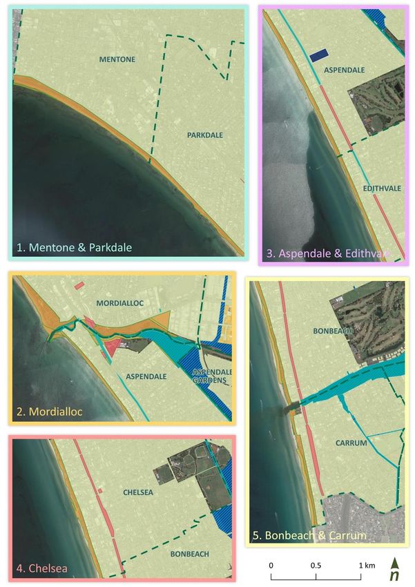
Kingston Council commenced CMMP development in August 2020, which has been undertaken in stages (Figure 1).

Figure 1. Timeline for developing the CMMP – currently at Draft CMMP.

A tailored stakeholder engagement plan informed the approach to engagement throughout the development of the
CMMP. This enabled insights and perspectives from the Kingston community and stakeholders to be considered and
included. Summaries of key engagement activities with stakeholders to date are available in Attachment A.

1.1    Strategic context                                              CMMP guidance
                                                                      DELWP is currently developing new CMMP guidelines, under
Coastal management reform in Victoria, led by the
                                                                      Victoria’s Marine and Coastal Reforms Final Transition Plan
Department of Environment, Land, Water and Planning                   (2018). The development of this CMMP has been guided by:
(DELWP), has involved the release of several key pieces                •    Marine and Coastal Act 2018
of legislation, policies and guidance material over recent             •    Marine and Coastal Policy (2020)
years. These reforms aim to support coordinated coastal                •    DELWP advice (formal and informal) on the
and marine management and provide the tools to                              development of new CMMPs (or conversion of CMPs)
identify and adapt to coastal hazards in the future.                        that is to be in accordance with the Act
                                                                       •    Existing Guidelines for the Preparation of Coastal
A summary of the relevant legislation and policies is                       Management Plans (2017)
provided in Table 1.                                                   •    Victorian Coastal Strategy (2014)

Table 1. Victoria’s marine and coastal policy context.

 Marine and Coastal Act 2018
 The spearhead of these reforms is the Marine and Coastal Act 2018 which replaces the previous Coastal Management Act 1995. It aims
 to provide a coordinated, simpler and more integrated approach to planning and managing the marine and coastal environment. The
 Act requires the development of a Marine and Coastal Policy, including a Marine Spatial Planning Framework, a Marine and Coastal
 Strategy, and the development of Coastal and Marine Management Plans.
 Victorian Marine and Coastal Council (VMCC)
 The Act also established the Victorian Marine and Coastal Council (VMCC) to provide independent advice on marine and coastal issues.
 Marine and Coastal Policy (2020)
 The Marine and Coastal Policy, endorsed in early 2020, has been developed in line with the Marine and Coastal Act under the
 supervision of the responsible ministers and the VMCC. It aims to manage the coastal environment to achieve the long-term vision for a
 ‘healthy, dynamic and biodiverse marine and coastal environment that is valued in its own right, and that benefits the Victorian
 community, now and in the future’.
 The Policy also outlines a ‘Planning and Decision Pathway’ (Figure 2) based on the objectives and guiding principles of the Marine and
 Coastal Act 2018. Planning, management and decision making under the Act, including development of a CMMP, must apply the policies
 within the steps of this Planning and Decision Pathway.
 Marine and Coastal Strategy (draft open for consultation)
 The Marine and Coastal Strategy will support and give effect to the Policy and detail priority actions. It will also be accompanied by an
 implementation and evaluation plan. The Marine and Coastal Strategy is now available for consultation,
 Coastal and Marine Management Plans
 Under the new Act, Coastal and Marine Management Plans are one of the management tools used to guide coastal and marine
 management and are intended to translate the marine and coastal policy and strategy to on-ground actions.

Kingston Coastal and Marine Management Plan                                                                                7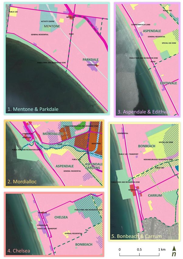
1.2    State policy context
The integration of the Policy context with coastal and marine management and planning is complex. Legislation,
policies, guidelines, plans, strategies and assessments from Commonwealth, State, regional and local government levels
evolve and interact with each other. A summary of key documents that relate to managing coastal and marine areas in
Kingston’s Local Government Area (LGA), and in particular this CMMP, is provided in Attachment B. This includes the
2009 and 2014 coastal management plans (predecessors of this CMMP) and strategies for open space, biodiversity and
climate change.

Victoria’s marine and coastal reforms focus on managing the health of marine and coastal environments and on
increasing the resilience of our ecosystems, communities and built assets, through improving and refining our
management, interaction and use of our marine and coastal environments. Kingston Council’s planning, management
and decision-making approach looks to align closely with the Marine and Coastal (MAC) Policy (2020). The Planning and
Decision Pathway from the Marine and Coastal Policy (2020) (Figure 2) shows how the objectives and guiding principles
of the Act should be used in decision making in the marine and coastal environment.

                 GUID E D BY T HE P RIN CIP LE S OF

            Integrated coastal zone                  Ecologically sustainable                Proportionate and risk-
                  management                               development                          based principle

             Evidence-based                Ecosystem-based                  Adaptive                   Precautionary
             decision making                 management                    management                     principle

                 DECISION MAKERS WILL                                           THROUGH

                  Acknowledge Traditional Owners'
        1         rights, aspirations and knowledge
                  Understand, acknowledge and act upon the rights
                  and aspirations of Traditional Owner groups for                      Taking a stewardship approach
                  Country                                                              to how we care for and manage the
                                                                                       marine and coastal environment
        2         Protect and enhance the marine
                  and coastal environment                                              Building understanding and
                  Protect and enhance intrinsic values and goods and                   knowledge
                  benefits of the marine and coastal environment                       of the condition and values of the
                                                                                       marine and coastal environment

        3         Respect natural processes
                  Understand the dynamic natural processes in                          Engaging
                  planning for and managing risks to people and                        with a wide variety of communities
                  assets                                                               and user groups that value the
                                                                                       marine and coastal environment
                  Strengthen resilience to climate
        4         change                                                               Collaborating
                  Understand the current and future stressors from                     across the breadth of people and
                  climate change and assess how well the marine and                    organisations involved in marine and
                  coastal environment can cope with and adapt to                       coastal management to deliver an
                  change and how that can be strengthened                              integrated and co-ordinated approach

                  Use and develop sustainably
        5         Consider the impacts and benefits of
                  existing and new use and development on the
                  environment, other users and the prosperity of future
                  generations

Figure 2. The Planning and Decision Pathway sets out how the guiding principles and policy must be considered in decision
making (Source: DELWP 2020).

Kingston Coastal and Marine Management Plan                                                                             8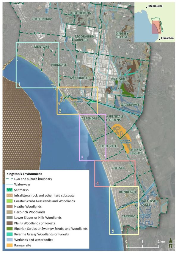
The integrated nature of marine and coastal environments means management must be holistic, informed by the
science (‘evidence-based’) and consider potential current and future risks. This includes the interaction of changing
conditions, such as natural hazards, climate change and population growth with our ecosystems and communities.

Several key pieces of work are currently being undertaken by DELWP that will inform and shape Kingston’s ongoing
management approach. A bay-wide coastal hazard assessment is working to better understand potential current and
future coastal hazards around Port Phillip Bay, and their possible implications on our marine and coastal areas. A
coordinated, bay-wide management approach is needed to enable land and marine managers, stakeholders and
communities to manage and protect the health and condition of the bay, and prepare for potential emerging change
and risk.

DELWP is also developing a state-wide approach to long-term coastal hazard resilience and adaptation, including a
framework and guidelines to support local governments, land managers and communities to adapt to climate change
impacts on the coast. This will include guidance for developing and implementing adaptation opportunities to increase
resilience, using a pathways approach to help inform decision making, planning, triggers and timing of actions.

Kingston’s CMMP looks to align and build upon the directions in the Marine and Coastal Policy (2020) and its guiding
principles, and prepare for integrating its management with the state-wide approach to hazard adaptation and
sustainable marine and coastal management.

Chelsea Beach
Kingston Coastal and Marine Management Plan                                                                   9
1.3    CMMP framework
The CMMP sets the strategic direction for Kingston’s marine and coastal management for the next 5-10 years and is to
be reviewed after five years. The framework for the plan, including the vision and objectives, has been informed by
community and stakeholder perspectives, reflecting their expectations and aspirations for the Kingston coastline. It also
draws on the experience of past management plans. Summaries of key engagement activities with stakeholders and the
community are available in Attachment A.

The proposed vision for Kingston’s coastal and marine areas is:

The intent of this vision can be defined as:

 Protect, enhance          Management and decision making of Council and stakeholder agencies influences
 and care for              environmental, social, cultural, recreational, and economic benefits of the Kingston
                           coastal and marine areas.
                           Considered management provides opportunities to protect, enhance and care for:
                                •    environmental health
                                •    facilities and amenity
                                •    sense of place, culture and history
                                •    access and connectivity
                                •    community connection
 Kingston’s                The CMMP takes a 'catchment through to coast’ perspective, acknowledging the
 coastal and               potential for upstream and inland processes to influence downstream coastal and
 marine areas              marine areas, in particular Port Phillip Bay. Kingston’s coastline covers 13 km, from
                           Charman Road, Mentone in the north, to Osprey Lane, Carrum in the south. The
                           coastal and marine environment extends across nearshore marine areas and inland, up
                           estuaries and into our catchments.
 Increasing our            The ability of our coastal and marine areas, including our communities and
 resilience                ecosystems, to withstand and thrive, despite pressures and future changes. These
                           changes might include natural hazards such as coastal erosion, climate change impacts
                           such as sea level rise, and population growth.
 Enjoyment and             Our coastal and marine areas are enjoyed and act to inspire in a wide range of ways.
 inspiration               This emphasises the importance of balancing the diversity of perspectives, interests
                           and values in management approaches and decision making.
 Present and               This includes addressing the needs and concerns of present and future generations of
 future                    residents, visitors and all users of the Kingston coastal and marine areas.
 generations

Kingston Coastal and Marine Management Plan                                                                 10
Using state policy as the foundation, objectives for managing Kingston’s coastal and marine areas have been shaped through discussions with council, agency and community stakeholders. These objectives cover the intended timeframe of the Marine and Coastal Policy (10-15 years) and are the long-term objectives for the Kingston CMMP (Figure 3). Figure 3. Long-term objectives for CMMP. The values, concerns, and opportunities analysis (Section 3) considers each objective for the Kingston local government area and its community. These objectives are to be realised through the implementation of short-term actions and projects guided by a range of medium-term goals. These are described further in Section 5. Under the Marine and Coastal Act 2018, CMMPs must be reviewed five years after commencement. Monitoring, evaluation, and review will play an important role in tracking the progress of CMMP implementation, success of the plan and identifying opportunities for refinement. Mordialloc Beach Kingston Coastal and Marine Management Plan 11
2     Kingston

2.1    Background
Located on the north-eastern side of Port Phillip Bay, the City of Kingston coastline extends for approximately 13 km,
from the suburb of Mentone in the north, to Carrum in the south.

The first custodians
This coastal region is recognised as land of the Bunurong Peoples. Historically, the coastal zone, water bodies (Carrum
Carrum Swamp) and water courses (including what is now known as Mordialloc Creek) were important food sources for
the Bunurong People. Artifacts such as middens and scar trees have been found along the foreshore and creek systems.

Although the land and seascape has experienced significant change, especially since Europoean settlement, the
Bunurong Traditional Owners continue to have a strong connection to Country. They have, and will continue to play an
important role in management of land, water, and the natural landscape, and have been managing sites of significance
within the region for many years.

Present day management
Today, management of the foreshore is a shared responsibility between the City of Kingston and other agencies
including DELWP, Parks Victoria, Melbourne Water, and other stakeholders, including the Bunurong Traditional Owners.

Table 2 and Figure 4 show the roles and public land management arrangements for the Kingston LGA. Strong
collaboration between all stakeholders will be important in successfully managing the coastal and marine areas of
Kingston and in achieving the objectives of the CMMP.

A significant proportion of Kingston’s coastline is the management responsibility of Council, as the Committee of
Management for the crown land foreshore.

Kingston Coastal and Marine Management Plan                                                                  12
Table 2. Land managers and other key stakeholders.

 Agency                          Role
                                 The Department of Environment, Land, Water and Planning (DELWP) is responsible for overseeing
                                 management of Crown land and marine areas for its environmental, conservation and recreational
                                 values. DELWP recently reformed coastal and marine management with the new Marine and
                                 Coastal Act 2018 and associated Policy and Strategy, which replaces the previous Coastal
                                 Management Act 1995.

                                 Kingston City Council has multiple roles in managing the coastal and marine environment. Council
                                 is the Committee of Management for large portions of coastal Crown land, administers the
                                 Kingston Planning Scheme and manages Council-owned foreshore infrastructure.
                                 Parks Victoria (PV) is the State government agency responsible for the management of protected
                                 areas of land and marine parks and reserves. Parks Victoria is the port and waterway manager for
                                 Port Phillip and Western Port (excluding the commercial port waters), responsible for safe
                                 navigation (boating and swimming zones, aids to navigation), moorings and berths, public piers and
                                 jetties, dredging and some other coastal reserves. This includes Mordialloc Pier, Patterson
                                 River Launching Way, and maintenance dredging activities at Mordialloc Creek and Patterson River.
                                 Melbourne Water (MW) is a statutory authority owned by the Victorian Government that manages
                                 and protects Melbourne’s major water resources. Melbourne Water has responsibilities with
                                 respect to managing water quality, drainage and flooding. Melbourne Water owns and maintains
                                 major water, sewer and drainage infrastructure within the City of Kingston, including drainage
                                 reserves and outlets.
     Traditional Owners          Previously a contested area, the entire City of Kingston LGA has recently been formally designated
                                 as being within the Registered Aboriginal Party (RAP) boundaries of the Bunurong Land Council
                                 Aboriginal Corporation.

                                 Bunurong Land Council Aboriginal Corporation (BLCAC) is a Traditional Owner organisation that
                                 represents the Bunurong people of the South-Eastern Kulin Nation.

                                 The Bay Watch Committee was made up of Councillors, local members of Parliament, relevant
    Bay Watch Committee          state agency staff, and community representatives. This Committee was specifically created to
                                 contribute to the development of Kingston's CMMP and will dissolve upon its adoption by Council.
                                 The Association of Bayside Municipalities (ABM) is an unincorporated association of the councils
                                 that have frontage to, and are affected by the tidal influences of, Port Phillip Bay. The ABM is the
                                 key representative of local government in relation to the sustainable management and health of
                                 Port Phillip Bay. The ABM approaches matters on a regional basis and is a forum for information
                                 exchange, advocacy, and collaboration to achieve integrated “whole-of-bay” outcomes.
                                 Better Boating Victoria (BBV) is a division within the Victorian Fisheries Authority, first established
                                 within the Department of Transport in March 2019. They oversee the implementation of boating
                                 reforms and the Victorian Government’s investment in boating infrastructure and facilities. This
                                 includes upgrading boat ramps and reviewing management arrangements for boating
                                 infrastructure.
                                 Environment Protection Authority Victoria (EPA) is Victoria’s environmental regulator. They are an
                                 independent statutory authority, established in 1971 under the Environment Protection Act 1970. A
                                 new Environmental Protection Act comes into effect on 1 July 2021. The EPA’s role is to protect
                                 human health and the environment by reducing harmful effects of pollution and waste.
                                 Level Crossing Removal Project (LXRP) was established by the Victorian Government to oversee
                                 one of the largest rail infrastructure projects in the state's history. There are recent and upcoming
                                 upgrades happening to the rail network within Kingston’s LGA, including redevelopment to stations
                                 used to access the coastline.
                                 Life Saving Victoria (LSV) (est. 2002) is an initiative of the Royal Life Saving Society Australia Victoria
                                 Branch (est. 1904) and Surf Life Saving Victoria (est. 1947). LSV work under the umbrella of
                                 Emergency Management Victoria (EMV) as part of the State’s emergency management services
                                 and is recognised by the Victorian Government as a core agency that plays a role in delivering
                                 EMV’s strategic action plan. LSV’s mission is to prevent aquatic related death and injury in all
                                 Victorian communities.

Kingston Coastal and Marine Management Plan                                                                                   13
Figure 4. Public land management arrangements along the City of Kingston coastline. Kingston Coastal and Marine Management Plan 14
Kingston Coastal and Marine Management Plan 15
2.2    Local government area
The City of Kingston’s LGA covers around 91 km2 of south-east Melbourne, approximately 15 km from the Melbourne
city centre. Kingston’s coastal suburbs are Mentone, Parkdale, Mordialloc, Aspendale, Edithvale, Chelsea, Bonbeach
and Carrum, while Waterways, Braeside Aspendale Gardens, Chelsea Heights and Patterson Lakes are adjacent to these
coastal areas (Figure 4).

Community
The LGA has an estimated population of around 167,000 people and is forecast to grow to around 198,000 by 2041
(forecast.id, 2021). Around 31% of Kingston’s population were born overseas and the municipality currently has an
ageing population with 23% of residents aged between 50 and 69 years of age in 2016 (profile.id, 2021). However, with
new development and regeneration, this may potentially see an increase in younger demographic.

Kingston’s coastal and marine areas have a wide range of stakeholders. In addition to land managers, there are various
public agencies, private organisations and community groups with an interest in the coast, each with particular values,
interests and concerns. Integration of the diverse range of users, activities, management actions and priorities is
complex and requires a considered and clear approach.

The Communication and Engagement Plan (C&EP) was developed to identify those stakeholders and inform the
approach to engagement throughout the development of the CMMP.

Industry and development
The region’s swampy heathland was transformed into farmland by early European settlers, who ran sheep and cattle,
while market gardens were also prevalent. Following the Second World War, Kingston rapidly expanded, with migration
driven population increases seeing significant development of these areas and the region becoming part of
Melbourne’s outer suburbs.

Manufacturing has historically been important in Kingston, but emerging employment sectors include construction,
accommodation and food services, health care and social assistance, and education and training. Employment is varied,
with many residents commuting to other areas of Melbourne for work. Transport networks and access are seen as key
drivers for the success of the local economy.

The coastal and marine areas, particularly Kington’s iconic foreshore and vital waterways, provide a diverse range of
commercial, development, business and tourism opportunities for residents and visitors.

Land use
Land use in the Kingston LGA is largely residential and industrial, with some large areas of open space. Major industrial
nodes are located around Moorabbin, Braeside, and Clayton South. There are also significant retail areas around
Southland Shopping Centre and Moorabbin DFO.

Transport and connectivity
The Mornington Peninsula Freeway runs through and along the boundary of the Kingston LGA, with the Nepean
Highway, Beach Road, Moorabbin Airport and Frankston and Dandenong railway lines providing further transport links.

A range of major expansion and upgrade works are currently being undertaken on several of these transport networks.
The Level Crossing Removal Project (LXRP) is seeing the major redevelopment and relocation of several stations on the
Frankston line (Edithvale and Bonbeach), while the Suburban Rail Loop link, with a station proposed at Cheltenham, will
improve connectivity to and from the region. The Mordialloc Freeway construction will provide a link between the
Mornington Peninsula Freeway and the Dingley Bypass.

As key transport linkages to Kingston’s coastal areas, these major changes have the potential to change local and
regional movement patterns and accessibility to the coastline. Facilities, including access and parking, may need to be
upgraded to accommodate these transport network changes.

Kingston Coastal and Marine Management Plan                                                                   16
2.3    Environmental setting
Kingston’s coastline extends approximately 13 km, from Mentone through to south of Carrum.

Landscapes and seascapes
Port Phillip Bay formed at the end of the last ice age, when rising sea levels flooded what was previously the lower
reaches of the Yarra River. Prior to European settlement, Kingston was a coastal saltmarsh and swampy area with
coastal scrub woodlands and grassy wetlands. These wetlands included the Carrum Carrum Swamp, which stretched
from Mordialloc to Frankston, and was bound by the coastal dunes.

A major change to the region’s landscape resulted from the draining of Carrum Carrum Swamp in 1879 for grazing and
housing. The swamp was drained by cutting through the sand dunes, creating the current Patterson River outlet.
Edithvale Wetlands is one of two wetland areas that remain from the original Carrum Carrum Swamp, comprising of
open freshwater marsh and shallow freshwater marsh, sustaining sensitive flora and fauna, particularly significant and
diverse birdlife, as well as providing flood mitigation.

The present-day coastline includes sandy beaches, recreational parks and reserves and major waterways and drainage
outlets. Although there are still significant ecological assets, including the Edithvale Wetlands Ramsar site, native
vegetation along the foreshore itself is limited to a thin strip with some sporadic pockets. The dune systems and coastal
reserves retain high-value flora and fauna, which may be threatened by high recreational and commercial demand for
foreshore areas, along with perceived impacts on aesthetic values.

Looking north-west towards Mordialloc Pier

Coastal processes
Kingston’s coastline is characterised as a swell-sheltered tidal embayment shore with narrow sandy beaches, backed by
mostly soft-rock materials (NCCARF, 2017). The dominant features of the City of Kingston coast are the mostly
unbroken, sandy beach, much of which is backed by dune ridges parallel to the coastline. This narrow dune system,
vegetated in grasses, scrub or woodland, including small pockets of remnant vegetation, represents a relatively thin
buffer between the sea and developed land. The estuaries of Mordialloc Creek and Patterson River intersect the
coastline. There are rocky areas (classified as infralittoral rock) in shallow, subtidal areas at Mordialloc and Parkdale.

Sand movement along this coast has some seasonal variation (tending northward during calmer, summer periods and
southward in the winter), with wind and wave action driving a net migration of sand in a southerly direction. Physical
barriers, including engineered structures and waterways, impact upon longshore transport process, trapping sand at
some locations. The northern beaches such as at Mentone are generally narrowing over time, while beaches north of
physical barriers (e.g. Mordialloc Pier) tend to widen (Bird, 2011).

Generally, northern coastal areas are higher in elevation than the south, and rocky headlands around Beaumaris
provide some protection to these northern areas from northern and westerly prevailing winds. Beaches in the south
Kingston Coastal and Marine Management Plan

                                                                                                              17
have been assessed as being more vulnerable to coastal erosion, and also experience greater loss of sand and
significant erosion scarps following storm events (Cardno, 2016, 2017).
The elevation of Kington’s dune system helps to limit coastal flooding in nearshore areas. However, some low-lying
areas further inland, particularly in the south, will likely be increasingly exposed to coastal flooding at high-tide, in
storm tide events, and with rising sea levels in the longer term. Mordialloc Creek, Patterson River and parts of the
drainage network provide flow paths for flooding to reach these low lying, inland areas.
Erosion in front of Carrum Surf Life Saving Club
Changing climate for Kingston’s coast
Changing climate conditions anticipate rising sea levels, more intensive riverine flooding, changes in wave action,
increases in swell energy and storm tide events and ocean acidification. Based on Intergovernmental Panel on Climate
Change (IPCC) projections, by 2100, global sea levels are projected to increase between 0.6 m and 1.1 m above 1986-
2005 baseline levels, under a high emission scenario; with a global average increase of approximately 0.8 m. For the
Kingston region, sea levels are estimated to rise by almost 0.7 m above the baseline by 2100 (CoastAdapt, 2017).
These changes in climate will likely influence storm tide extents (inundation areas), shoreline position and response,
magnitude of storm events and resulting sand loss off beaches, as well as changes in shoreline recovery (beaches
rebuilding during calmer conditions). The existing stormwater network and its outfalls within coastal zone, will likely be
impacted by rising sea levels, reducing drainage efficacy and high intensity rainfalls will put pressure on the capacity of
the broader network, including at the foreshore.
The Port Phillip Bay Coastal Hazard Assessment (PPBCHA) is currently being undertaken, which will help Kingston to
better understand their projected coastal hazards at a local scale and identify vulnerabilities of their foreshore in being
able to withstand current and future hazards. Improved understanding of potential coastal hazard risks, opportunities
for adaptation, and future-focused planning and decision making enables improved preparedness to respond and
recover following hazard events (such as erosion and flooding).
More broadly across the LGA, rising temperatures, hotter days and heatwave events further highlight the impacts urban
heating, and the importance of ’green’ and ’blue’ spaces within and near to our urbanised areas. This emphasises the
value of our coastal and marine environments in helping with urban cooling and respite during heat waves.
Council is striving to leave a positive legacy for future generations through addressing climate change. Declaring a
climate and ecological emergency, they have made a commitment towards limiting global warming. Council has
adopted its own Climate and Ecological Emergency Response Plan, which includes a range of initiatives and pledges for
emissions reductions via mitigation measures. They are also actively encouraging the Kingston community to take
positive action.
Kingston Coastal and Marine Management Plan
18Coastal and marine management
The now urbanised coastline is a heavily modified environment. The legacy of a range of historical and present-day
coastal management and engineering decisions can be seen along this coastline. Masonry, concrete seawalls and
promenades, rock revetments, rock armouring around coastal infrastructure and geofabric bag protection structures
have been and are still used to manage coastal erosion processes and mitigate flooding impacts. Renourishment and
active sand management (i.e. artificially moving sand along the beach) has been happening since late 1970s, including
at Mentone, Parkdale and Aspendale. Conservation efforts such as vegetation and weed management and access
control help to protect vital dune stabilising vegetation and habitat areas.
There is a wide variety of infrastructure and facilities that support the community to live near, enjoy and use these
areas, such as stormwater assets, roads, piers, jetties, boat ramps and access, surf lifesaving clubs, recreational and
sporting clubs, bathing boxes, pathways and trails.
The region’s natural processes have been permanently altered and will continue to change. However, it is important
that future management decisions carefully consider potential influences on these natural systems.
Shaped by previous management plans, council plans, community sentiment, recent management of these areas brings
together an array of actions, led by various agencies including:
• provision, maintenance and upgrades to infrastructures and facilities
• connectivity and access improvements – roads, car parks, shared trails, walkways, beach access
• drainage and water quality improvements
• enhancement and protection of vegetation, habitat and sensitive sites
• provision of services – including surf lifesaving clubs, emergency response
• coastal hazard mitigation
• beach cleaning and litter management
• zoning, signage and enforcement.
All abilities access matting at Mordialloc lifesaving club
Kingston Coastal and Marine Management Plan
193 Values, concerns and opportunities
Through discussions, workshops and online activities from mid-2020 to mid-2021, community and stakeholder
perspectives have been gathered to understand key values, concerns and opportunities for Kingston’s marine and
coastal areas.
Kingston’s coastal and marine areas are valued, used and enjoyed by the community and its visitors in a wide variety of
ways, providing:
• community benefits such as open space, clean beaches, good air and water quality, natural beauty and views,
peace, and serenity
• a healthy environment that supports unique and diverse ecosystems and is further enhanced by conservation
initiatives
• a natural buffer between the land and the sea, that provides protection and increases our resilience to hazards
• a connection with history, character, identity and culture
• facilities, access and open space that improve recreational opportunities and promote and support healthy, active
lifestyles, wellbeing and enjoyment
• commercial, development, and business opportunities.
As the coastal zone plays an important role in the lifestyle of Kingston residents and its visitors, considered strategic
planning is needed to manage the increasing pressures from development and growth, a changing climate and aging
and inadequate infrastructure, ensuring it remains a desirable place to live, work, and visit.
This section summarises values, concerns and opportunities for Kingston’s marine and coastal areas, and has been
framed around the long-term objectives of the plan, with consideration to the intended outcomes of the Marine and
Coastal Policy (2020).
Kingston Coastal and Marine Management Plan
20Objective 1: Acknowledge and act on our Traditional Owners’ rights, aspirations & knowledge
Kingston context
In managing our marine and coastal
areas, there is the need to listen to, act The region’s Indigenous history brings together a strong connection with Land, River and Sea Country for the Bunurong Traditional Owners. There are many important stories and experiences to be shared from living within this
upon and respect Traditional Owners’ environmental setting. Rich storytelling tells of the changes in land and seascape, interactions with flora and fauna, and significant sites, from places of ritual and ceremony to activities of everyday life. It is acknowledged that
voices and knowledge throughout European settlement significantly altered the way of life for the Bunurong Peoples and drastically modified the land and seascape. This included the draining of Carrum Carrum Swamp and associated floodplains and the
planning, management and decision channelisation of creeks.
making.
The region’s foreshore, waterways and the swamplands were abundant food and water sources for the Bunurong Peoples. These resources included eels, fish, birds, crustaceans, molluscs and plants, such as water ribbons. There
We can support and enable our current are thought to be many sites of cultural significance throughout Kingston’s coastal areas (Figure 5), many of which remain undocumented. Significant sites containing artefacts, scar trees and shell middens are located within the
and future generations of Traditional region, including along foreshore and waterway areas.
Owners to care for and respect Country
through self-determination. There is an opportunity to learn from marine and coastal knowledge and practices of Traditional Owner groups who have managed marine and coastal areas over time. Acknowledgement and appreciation of this history allows
us to draw from such knowledge in our management approaches, protecting and enhancing what has come before, enabling its continuation in the future.
Values Concerns Opportunities
• Strengthen partnerships with the Bunurong Traditional Owners
• Places and areas of cultural sensitivity • Limited opportunity for involvement in planning decisions and management of the
• Sites of cultural significance – middens, burials, etc.
foreshore • Enable inclusion of Traditional Owner experience and knowledge in management
• Limited awareness and understanding of the region’s cultural history approach
• Connectivity along the coastline
• Disconnection between the Bunurong Traditional Owners and Country • Protect, promote and retain culturally significant sites
• Sight lines and views of the bay and sky from the coast
• Damage/loss of culturally significant sites • Enrich the coastal experience by connecting both Aboriginal and non-Aboriginal
people with land and sea
• Provide opportunities for re-connection with Country
• Promote access/connection along the entire coastline
• Promote connection to Country, share stories through walking tours, interpretative
signage, educational opportunities, etc.
• Indigenous art sculptures along foreshore areas
• Explore opportunities for an indigenous cultural centre/hub/place
*Traditional Owner context, experience and values, concerns and opportunities will continue to evolve as part of our upcoming engagement activities
Kingston Coastal and Marine Management Plan 21Kingston Coastal and Marine Management Plan Figure 5. Areas of Cultural Heritage Sensitivity.
*We note that this map does not reflect all locations of cultural significance,
and that many more are likely to exist throughout the region .Kingston Coastal and Marine Management Plan
Objective 2: Protect and enhance the environment, from our catchments through to the Bay

 Protection and enhancement of our marine and              Kingston context
 coastal areas needs an integrated approach,
 extending from our catchment through to our               Kingston’s coastal and marine areas, its estuaries, dune systems and coastal reserves, sustain unique and important flora and fauna communities including native and remnant vegetation, shorebirds, saltmarsh
 coastline. It is recognised that the health, diversity,
                                                           and rare and threatened species (Figure 6). The nearby Edithvale Wetlands are recognised as a Ramsar site supporting an abundance of bird and aquatic life. Rocky outcrops along with marine-based structures
 function, resilience and connectivity of important
                                                           (i.e. jetties, rock breakwaters) provide habitat for marine life, including mussels and crustaceans, also encouraging fish and stingrays in and around these areas.
 ecosystems and habitats within our landscapes and
 seascapes are critical to their success and survival.
 They have important intrinsic values along with           This environment is dynamic and constantly changing. While human intervention has altered the landscape, both in our catchments and along the coastline, shifts in climatic conditions are also resulting in
 providing essential ecosystem services for our            change. The natural dune system and vegetation area vital part of the local ecosystem. They also provide a narrow, natural buffer from coastal hazards, at the interface between the land and the sea. This dune
 community. These areas also hold high cultural and        system is intersected and influenced by the estuaries of Mordialloc Creek and Patterson River. As key watercourses directing flows to the bay, the interacting upstream catchment behaviours and management
 heritage value, tell stories and shape identities.        also influence what happens on the coast, particularly for water quality (i.e. sediments and nutrients), litter and pollution.

 As we look to protect and enhance through informed,       The established and maturing vegetation throughout Kingston’s foreshore areas play an important role in our ecosystems, providing habitat and strengthening our dunes. However, sometimes vegetation has
 strategic management, and reflect on how we enjoy         the potential to impact on bay views and access, and can be an issue for some local residents, resulting in tree vandalism such as illegal clearing and poisoning. Council’s current management response to such
 these areas, these values, natural features, natural
                                                           behaviour includes replacement planting, signage and education campaigns.
 processes and the changes that ensue must be
 respected. Threats and pressures, and their potential
 impacts on these sensitive systems, must be               It is important to acknowledge the diverse range of historic and cultural experiences for the region and its foreshore areas, finding opportunities to share this knowledge with current and future generations. In
 considered and carefully managed. Importantly, the        addition to an extensive Indigenous history, our more recent European history is also valued by residents and visitors, including our connection to fishing, boating and access to water, our coastal lifestyle
 value and benefit of our marine and coastal Crown         including our bathing boxes, and to other marine based industry.
 land enjoyed by our communities should not
 compromise the available benefit for future               The natural environment and healthy ecosystems provide many and varied benefits to humans (ecosystem services). However, environmental and human needs can also be conflicting. Management requires a
 generations.                                              holistic and balanced approach from catchment to coast, to ensure the health of Kingston’s coast and broader Port Phillip Bay is maintained. There are opportunities to find integrated and innovative ways to
                                                           protect and enhance these vulnerable communities and ecosystems, while also respecting natural processes. Having access to our sandy beaches, open space, healthy and clean environments, natural beauty,
                                                           and views across the bay is a crucial part of the lifestyle, health, well-being and enjoyment of our community and visitors.
Values                                                                                     Concerns                                                                                Opportunities
                                                                                                                                                                                    • Protect and enhance:
 • Health and diverse ecosystems and habitats                                                •   Waste management, litter, fishing waste
                                                                                                                                                                                      − native and remnant coastal vegetation, flora and fauna
 • The foreshore and creeks are key corridors, providing recreational and habitat links – •      Poor water quality arising due to pollution, sedimentation                           − water quality
   Living Links Program                                                                                                                                                               − wetlands and creeks
                                                                                          •      Saltwater intrusion of groundwater (Edithvale Wetlands)
 • Natural features and landscapes, parklands, wetlands, vegetation etc.                                                                                                              − important ecosystems, habitat and natural ecology (marine and terrestrial)
                                                                                          •      Seaweed removal/smell                                                                − dune systems / coastal hazard buffers
 • Saltmarsh areas                                                                                                                                                                  •  Improve:
                                                                                          •      Invasive weeds and pest species, non-native species
 • Ramsar listed Edithvale Wetlands                                                                                                                                                   − existing litter and waste management
                                                                                          •      Illegal vegetation clearance                                                         − stormwater management - pollutant traps (increase and prioritise maintenance)
 • Clean and well-preserved beaches                                                                                                                                                   − access
                                                                                          •      Pollution from industry
 • Rockpools and marine life (including fish, stingrays, aquatic vegetation)                                                                                                          − vegetation cover, tree canopy and shade
                                                                                          •      Dune and vegetation damage due to informal access                                    − erosion mitigation
 • Remnant Coastal Banksia Woodland                                                                                                                                                   − existing green spaces, new planting
                                                                                          •      Severe erosion scarps –beach safety and boat ramp access
 • Sight lines and views (the bay and city)                                                                                                                                         • Communicate and/or enforce:
                                                                                          •      Deteriorating ecosystem health and loss of marine life                               − illegal vegetation clearing
 • Open spaces within the community; leisure centres, parks, foreshore and gardens                                                                                                    − zoning – e.g. conservation areas, boating, fishing, dog walking
                                                                                          •      Noise pollution from motors e.g. jet skis, boats, drones
 • Fresh, clean air                                                                                                                                                                 • Promote/enhance interaction with and education about the natural environment
                                                                                          •      Limited vegetation/trees in some places                                            • Acknowledge the value and importance of significant ecosystems and our dunes
 • Non-polluted environments
                                                                                          •      Upstream activities impacting receiving waters, including major waterways and bay     through education
 • Good water quality in the catchments and bay                                                                                                                                     • Protect and retain the cultural heritage values
                                                                                                                                                                                    • Engagement with other stakeholders (Melbourne Water, Councils) and upstream
                                                                                                                                                                                       industry to reduce pollutants
                                                                                                                                                                                    • Emissions reduction initiatives

Kingston Coastal and Marine Management Plan                                                                    24
Figure 6. Ecosystems, habitats. Kingston Coastal and Marine Management Plan 25
Kingston Coastal and Marine Management Plan 26
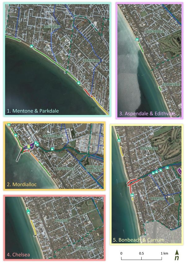
Objective 3: Respect the natural environment and proactively strengthen our resilience to a changing climate

                                                                   Kingston context
 Natural process of the marine and coastal environment become
 hazards when they impact on our social, environmental, cultural   While proximity to the coast is one of the benefits of living in Kingston, it also means the municipality is exposed to coastal processes and the effects of climate change. A highly urbanised coastline, Kingston’s
 or economic values. These hazards change how we can use,          coastal zone intersects with a range of assets and infrastructure. These include seawalls, creek outlets, access points and other coastal structures, stormwater outlets, roads and footpaths, and residential and
 interact with and enjoy the coast.
                                                                   commercial assets situated within the coastal zone (Figure 7). Public and private infrastructure in these areas means only a narrow, natural buffer remains between the land and sea. The legacy of past coastal
 Understanding coastal hazards, risks and potential climate        and catchment management and engineering decisions also present a challenge.
 change impacts allows appropriate planning, management and
 where possible mitigation of coastal hazard impacts. Adaptation   Healthy ecosystems, such as the dune system along Kingston’s coast, have an important role in the coastline’s resilience. Vegetation provides dune stability and habitat to sustain and support diverse flora and
 is a core component of planning in the marine and coastal         fauna. The region’s natural assets, including sensitive and significant marine and terrestrial ecosystems, are also potentially vulnerable to changing conditions, and may require management to aid adaptation.
 environment and is used to manage uncertainty and build
 resilience of our marine and coastal areas, for our ecosystems,   As a coastal community, the Kingston LGA faces risk from climate change through flooding from sea level rise and storm tide inundation. Over the next ten years (by 2030), sea levels in the Kingston region are
 our assets and our community.                                     expected to rise around 0.1 m under a very high (RCP 8.5) scenario from the 1986-2005 baseline (CoastAdapt, 2017), and almost 0.7 m by 2100. The region already experiences the effects of erosion, with loss of
                                                                   sand from beaches resulting from storm events and sediment transport dynamics. The elevation provided by the dune system and cliffed areas of Kingston’s foreshore help to limit flooding close to the coast.
 Through increasing the capability and capacity of land managers   However, coastal inundation via waterways and stormwater networks can potentially impact low-lying areas further inland, as well as limit the efficacy of drainage and other infrastructure for the region (i.e.
 and decision makers, as well as our community, we can be more
                                                                   paths, roads, access) (Figure 7).
 responsive to coastal hazards. Our emergency response can also
 be shaped to prevent or minimise consequences on human
 health and safety, property, the natural environment and local    Adaptation is needed to increase the resilience of our marine and coastal ecosystems, communities and built assets. Council currently works to align with the Policy, and Victoria Planning Provisions (VPP) in
 values, and enable recovery and reduction in future risk.         planning for and managing coastal hazard risk and climate change impacts. Planning is required to consider sea level rise of no less than 0.8 m by 2100, and takes into account the combined effects of tides, storm
                                                                   surges, coastal processes and local conditions. Improved understanding of potential coastal hazard risks, opportunities for adaptation, and future planning and decision making enables improved preparedness to
                                                                   respond and recover following hazard events (such as flooding and erosion). Council is working to identify vulnerabilities and inadequacies of their foreshore in being able to withstand current and future hazards.
                                                                   Available coastal hazard overlays are presented in Figure 8 and are soon to be updated with the Port Phillip Bay Coastal Hazard Assessment (PPBCHA).

 Values                                                                                              Concerns                                                                                        Opportunities
•    Natural coastal and riverine processes and natural areas – wetlands, sediment transport,       •    Sea level rise                                                                              •   Strengthen understanding of local coastal processes
     beaches, waterways etc.                                                                        •    Coastal erosion impacting on values                                                         •   Strengthen understanding of present and emerging coastal hazards
•    Coast, wetlands and creeks providing cool areas and reducing urban heat                        •    Coastal flooding impacting on values                                                        •   Strengthen understanding of role our important ecosystems in our resilience
•    Saltmarsh and wetlands providing green areas to absorb carbon from the atmosphere              •    Increasing frequency and severity of future coastal hazards and storm activities            •   Increase community awareness/understanding of:
•    Community/public facilities and assets, including life saving clubs                            •    Limited current (up to date) understanding of local coastal hazard processes to inform          −    changing climate and the dynamic coastal and marine environment
•    Private property and assets                                                                         planning and management                                                                         −    current and possible management measures
•    Human health and safety                                                                        •    Encroaching landward and seaward pressures on narrow dune system/ natural buffer                −    adaptation and resilience options
•    Dune system acting as a natural buffer to coastal hazards                                      •    Longevity of current flood mitigation measures (levees) to withstand hazard and sea         •   Embed consideration of coastal hazards into decision making and design
                                                                                                         level rise predictions
                                                                                                                                                                                                     •   Integrate the latest hazard mapping, including Port Phillip Bay Coastal Hazard
                                                                                                    •    Catchment impacts from coastal processes (bank erosion)                                         Assessment into decision making and management planning
                                                                                                    •    Erosion impacts on usage and access (boating, recreational activities, wheelchair access)   •   Upgrade or modify infrastructure to accommodate/withstand changing
                                                                                                    •    Limited monitoring and local data                                                               conditions
                                                                                                    •    Guidance/direction and funding to manage storm surges and long-term impacts of              •   Minimise dune disturbance and maintain/enhance vegetation, to aid dune
                                                                                                         climate change                                                                                  stabilisation, impacts of wave and wind erosion
                                                                                                    •    Beach renourishment                                                                         •   Maintain and enhance vegetation in catchment areas (including wetlands) to aid
                                                                                                    •    Changes/impediment of sediment supply                                                           bank stabilisation

                                                                                                    •    Impacts of changing coastal conditions on stormwater drainage network performance           •   Explore sediment management opportunities, including use of available dredge
                                                                                                                                                                                                         material

Kingston Coastal and Marine Management Plan                                                                                      27
Kingston Coastal and Marine Management Plan Figure 7. Coastal infrastructure.
28Kingston Coastal and Marine Management Plan
29AEP: Annual exceedance
probability is the
probability of a storm event
occurring in a given year.
Figure 8. Available coastal hazard overlays.
Kingston Coastal and Marine Management Plan Note: data to be updated with results from Port Phillip Bay Coastal Hazard Assessment.
30Kingston Coastal and Marine Management Plan
31Objective 4: Promote wise and sustainable use of our coastal and marine areas, to enjoy now and into the future
Kingston context
Managing our use, interaction and enjoyment of our coastal and
marine areas needs to balance a range of values, interests and In addition to the natural values of Kingston’s foreshore and nearshore areas, people enjoy the recreational opportunities these areas provide. Walking, running, cycling, dog walking, swimming,
demands. To ensure our coastal communities remain desirable, now fishing, wind and water sports, and boating are some of the many activities enjoyed in these areas. The coastline offers a place for people to relax, connect with nature and enjoy the coastal and
and into the future, an ecologically, socially and economically
marine environment. The diverse range of activities offered by the foreshore requires a balanced management approach. For dog owners, the ability to bring their dogs to the beach and have them
sustainable approach is needed for our management of:
off-leash at defined times of day is clearly a valued beach experience for parts of the community. However, it requires careful management to minimise potential impacts on the enjoyment for other
beach users. Similarly, shared trails need to provide for both pedestrians and cyclists and ensure their safety.
• coastal settlements – including residential, commercial and
industrial areas. Management must recognise the importance of
natural and open space, coastal character, the changing Access and connectivity are vital in getting our community and visitors to, from and between areas of our foreshore (Figure 9). This relies on connected and well-planned transport networks
conditions of these environments, and the impacts of use, throughout Kingston’s coastal zone and beyond, from shared paths and trails, roads and carparking, public transport linkages, through to all-abilities access opportunities. Recent and upcoming
growth and urbanisation changes to the rail network as part of the LXRP requires consideration to ensure provision of clear access thoroughfares to and from the coast. An internal access audit has also identified several
locations where upgrades may be required to achieve accessibility guidelines.
• recreation and tourism – needs strategic planning for facilities
and services to ensure they are appropriate, offer a diversity of
Many structures located throughout Kingston’s coastal and marine zones influence how people and the environment interact with the coast. These structures (such as pathways, seating, fences, boat
experiences and consider public safety
ramps and walls) help to support various activities, improve amenity, and/or protect and enhance our sensitive areas. Natural areas are valued for their recreational and ecological benefits. These
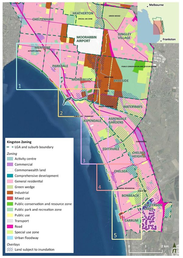
• buildings, structures, and access - must consider the values are potentially threatened by continued population growth, housing demands, and limited available space. Planning scheme zones, overlays and other controls (Figure 10) need to ensure
environmental setting, including hazards, be accordingly located growth is carefully managed in a sustainable way.
and designed to minimise impacts on the environment, sensitive
areas and landscape and ensure public safety. The functional There is a mix of publicly and privately-owned facilities, buildings and infrastructure in these areas (Figure 7 and Figure 12): from facilities (i.e. piers, jetties, and boat ramps) and buildings (i.e. houses,
need for structures located within marine and coastal areas surf lifesaving clubs, recreation clubs, bathing boxes), to infrastructure (i.e. stormwater, amenities, roads and carparks) and coastal management and protection (i.e. seawalls, rock revetments,
should be carefully considered and seek opportunities for
boardwalks and walkways, access points). In sections of the coast, settlements encroach on the foreshore, with houses directly on and behind dunes, facing onto the bay.
broader public benefit
• marine and coastal industries - requires a sustainable approach Some of these structures are currently and will increasingly be exposed to coastal hazards. Consideration needs to be given to the functionality, maintenance and community benefit, along with the
to protect and enhance the marine and coastal environment, to need for buildings and structures to be located within the foreshore zone. Currently, council-managed structures undergo routine condition assessment, identifying and prioritising necessary
ensure the health and longevity of these ventures. maintenance and upgrades for delivery in operational and capital works programs. This process may need to evolve to ensure timeliness of management response and appropriate longer-term
management of at-risk structures. Dredging and bank stabilisation are used to help maintain boating opportunities offered by Patterson River and Mordialloc Creek, however, the longevity of this
response into the future needs to be considered.
Importantly, as we enjoy, use and benefit from Kingston’s marine and coastal environments, potential direct or indirect impacts and threats that may arise from our activities and behaviours must be
considered and appropriately managed.
Kingston Coastal and Marine Management Plan 32You can also read