Hume Bushfire Management Strategy 2020 - delwp.vic.gov.au - Safer Together
←
→
Page content transcription
If your browser does not render page correctly, please read the page content below
Hume Bushfire
delwp.vic.gov.au    Management
                    Strategy 2020
                                   Fuel management
                      Bushfire Risk Engagement Areas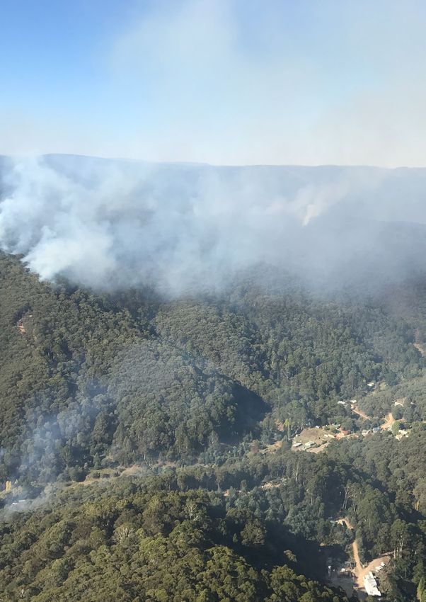
Acknowledgements
   We acknowledge and respect Victoria’s Traditional
   Owners as the original custodians of the state’s land and
   waters, their unique ability to care for Country and deep
   spiritual connection to it. We honour Elders past and present,
   whose knowledge and wisdom has ensured the continuation of
   culture and traditional practices.
   We are committed to genuinely partner and meaningfully engage
   with Victoria’s Traditional Owners and Aboriginal communities to
   support the protection of Country, the maintenance of spiritual and
   cultural practices and their broader aspirations in the 21st century
   and beyond.

The authors would like to thank members of the Hume Safer Together Coordinating Committee and the Safer
Together Working Group for their advice on the technical approach and contribution to this publication.

We also thank the community members who have participated in focus groups and completed surveys as
part of developing this plan.

We thank our colleagues and partners in the following organisations who have provided valuable input
supporting this project: Country Fire Authority, Department of Environment, Land, Water and Planning,
Emergency Management Victoria, Landcare, Parks Victoria, Regional Development Victoria, Department
of Defence, Regional Roads Victoria, Local Governments of Hume, Victoria State Emergency Service, HVP
Plantations, North-East Water, North-East Catchment Management Authority, North East Apiary Association,
Vignerons Association, VicForests.

   Aboriginal people should be aware that this publication may contain images or names of
   deceased persons in photographs or printed material.

Cover photograph:
Aerial view of the Woods Point Brewery creek planned burn conducted in 2018
Photo credit: Shaun Lawlor, FFMVic, Hume

© The State of Victoria Department of Environment, Land, Water and Planning 2020

This work is licensed under a Creative Commons Attribution 4.0 International licence. You are free to re-use the
work under that licence, on the condition that you credit the State of Victoria as author. The licence does not apply
to any images, photographs or branding, including the Victorian Coat of Arms, the Victorian Government logo and
the Department of Environment, Land, Water and Planning (DELWP) logo. To view a copy of this licence, visit http://
creativecommons.org/licenses/by/4.0/
Printed by
ISBN 978-1-76105-004-6 (Print)
ISBN 978-1-76105-005-3 (pdf/online/MS word)
Disclaimer
This publication may be of assistance to you but the State of Victoria and its employees do not guarantee that the
publication is without flaw of any kind or is wholly appropriate for your particular purposes and therefore disclaims all
liability for any error, loss or other consequence which may arise from you relying on any information in this publication.

Accessibility
If you would like to receive this publication in an alternative format, please
telephone the DELWP Customer Service Centre on 136186, email customer.service@
delwp.vic.gov.au or via the National Relay Service on 133 677 or at www.relayservice.
com.au. This document is also available on the internet at www.delwp.vic.gov.au.
Hume   1

Contents
Abbreviations and Definitions                                 2
Introduction                                                  4
    Recognising the role of Victoria’s Traditional Owners      7
  Bushfire management planning                                 9
    Strategic planning                                         9
    Operational and tactical planning                          9
    Other bushfire management actions                          9
  About this bushfire management strategy                     13
    Method overview                                           14
    Identifying and assessing risk to values and assets       15

Our landscape context                                         16
  Bushfire history and patterns                               20
  Values and assets                                           22
    Human landscape                                           22
    Aboriginal cultural heritage                              25
    Natural landscape                                         27

Our objectives                                               30
Our risk management approach                                 32
  Bushfire Risk in Hume Region                                32
    Higher risk areas in Hume                                 33
    Lower risk areas in Hume                                  33
  Why model house loss?                                       36
  How do we model house loss?                                 36

Our fuel management strategy                                 37
  Fire Management Zones                                       37
    Ecosystem resilience                                      41
    About our fuel management strategy                        42
    Victoria’s residual risk                                  44

Bushfire Risk Engagement Areas                               46
Implementation                                               48
Monitoring, evaluation and reporting                         49
Appendix 1: Program logic                                    50
References                                                    51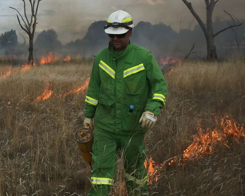
2   Bushfire Management Strategy

    Abbreviations and Definitions
     Abbreviation    Term

     APZ             Asset Protection Zone
                        an area around properties and infrastructure where we intensively manage fuel to
                        provide localised protection to reduce radiant heat and ember attack on life and
                        property in the event of a bushfire

     BMZ             Bushfire Moderation Zone
                        an area around properties and infrastructure where we manage fuel to reduce the
                        speed and intensity of bushfires and to protect nearby assets, particularly from ember
                        attack in the event of a bushfire

     BREA            Bushfire Risk Engagement Area
                        parts of the landscape, on public and private land, where managing bushfire fuels is
                        most effective in reducing risk. It guides agencies and communities working together to
                        determine the best actions in their local area

     CAR             Comprehensive, Adequate and Representative reserve system

     CFA             Country Fire Authority

     DELWP           Department of Environment, Land, Water and Planning

     EFG             Ecological Fire Group
                        a broad native vegetation classification unit based on grouping multiple Ecological
                        Vegetation Classes that share similar ecological responses and relationships, in
                        particular fire responses

     EMV             Emergency Management Victoria

     FAME            Fire Analysis Module for Ecological values

     FFMVic          Forest Fire Management Victoria
                        comprised of staff from DELWP, PV, Melbourne Water and VicForests when working in
                        bushfire management on public land

     FMZ             Fire Management Zone
                        for fuel management purposes, public land in Victoria is classified into four fire
                        management zones: asset protection zone, bushfire moderation zone, landscape
                        management zone, and planned burning exclusion zone

     Ha              Hectares

     HVEA            High Value Ecological Area

     IMT             Incident Management Team

     JFMP            Joint Fuel Management Program

     LMZ             Landscape Management Zone
                        an area where we manage fuel to minimise the impact of major bushfires, to improve
                        ecosystem resilience and for other purposes (such as to regenerate forests and protect
                        water catchments)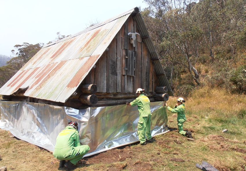
Hume   3

Abbreviation    Term

MER             Monitoring, Evaluation and Reporting

PBEZ            Planned Burning Exclusion Zone
                   an area where we try to avoid planned burning, mainly because ecological assets in this
                   zone are primarily intolerant to fire

PV              Parks Victoria

RAP             Registered Aboriginal Party

Residual risk      the amount of risk that remains after bushfires and fuel management activities reduce
                   fuel. Residual risk is used by DELWP as a performance measure

RSFMPC          Regional Strategic Fire Management Planning Committee

SDM             Structured Decision Making

TFI             Tolerable Fire Interval
                   a term which expresses the minimum or maximum recommended time intervals
                   between successive fire disturbance events at a site or defined area for a particular
                   vegetation community. The time interval is derived from the vital attributes of plant
                   species that occupy the vegetation community. The TFIs guide how frequent fires
                   should be in the future to allow the persistence of all species at the site or defined area.

VFRR-B          Victorian Fire Risk Register – Bushfire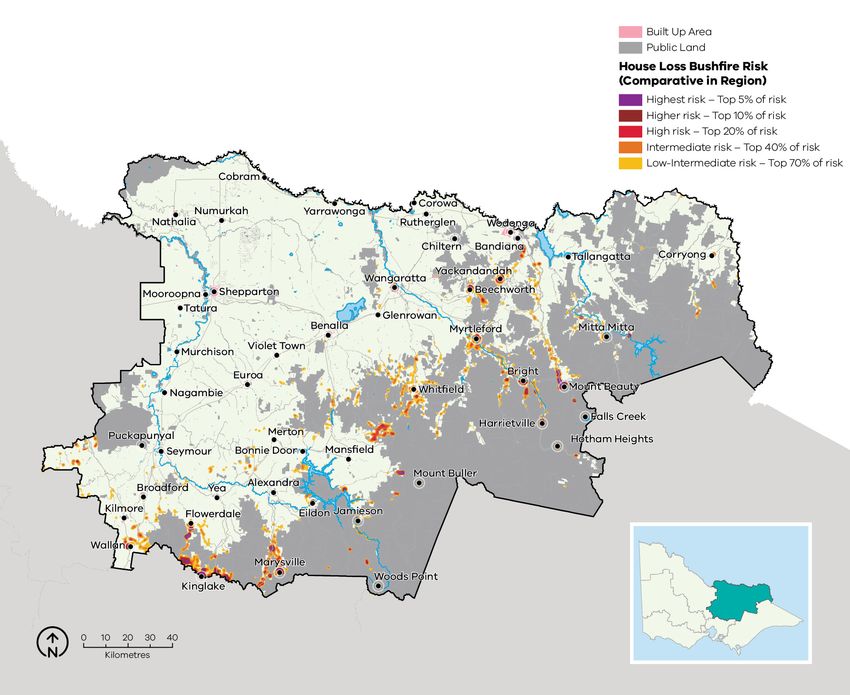
4   Bushfire Management Strategy

                                      Mt Buller Alpine Resort, 11th Jan 2007. Snow making machines were used to cool the chairlift cables.
                                                                                                    Photo credit: Bob Bateup, Mansfield

    Introduction
    Victoria is one of the most bushfire-prone areas in the world. Victorians are accustomed
    to living with bushfire risk, which is the likelihood and consequence of bushfires. It
    includes the likelihood of a fire starting and spreading across the landscape, and the
    consequences of it impacting the things we value: people, communities, houses and
    farms, infrastructure, our economy and the natural environment.

    Bushfires are driven by three key factors – fuel,                 in and near forested areas increases the bushfire
    weather and topography – which together make                      risk, as more people enter areas where major
    up the ‘fire behaviour triangle’. These three factors             bushfires are more likely to impact. The Victorian
    combine to affect how a bushfire behaves: how                     community is changing in other ways, with an aging
    fast it travels, where it spreads, and how intensely it           population and decreases in volunteering in some
    burns. Fuel management is important, because it is                areas, leading to an increase in vulnerability to
    the only element of the fire behaviour triangle that              bushfire. For plants and animals, drought, invasive
    we can influence.                                                 species incursion, as well as habitat loss and
                                                                      fragmentation increase the susceptibility to negative
    Bushfire fuels are the leaves, bark, twigs and shrubs             bushfire impacts.
    that are burnt by fire. The fuel type, dryness, size,
    moisture content and arrangement can all affect                   Our changing climate – bringing rising average
    the speed, size and intensity of a bushfire. Fuel                 temperatures, more hot days and less rainfall –
    management includes planned burning — lighting                    means bushfire risk is constantly increasing as fuels
    and managing planned fires in the landscape — and                 dry out and extreme fire weather events increase.
    mechanical treatment — mowing, slashing, mulching                 Bushfires with the worst consequences typically
    and using herbicides. Fuel management activities                  occur during extreme weather conditions (such
    reduce the amount of fuel across our landscape,                   as during very hot, dry and windy periods). The
    decreasing the fire behaviour of bushfires, helping               disastrous 2019–20 bushfire season, followed periods
    limit their spread and intensity when they occur, and             where parts of Eastern Australia – extending from
    making it easier for our firefighters to control them             Tasmania through Victoria, New South Wales and
    and lessen their impacts.                                         into Queensland – had experienced their driest
                                                                      conditions on record. Over 1.5 million hectares (ha)
    Bushfire risk is influenced not only by how a bushfire            in Victoria were burnt and large areas of eastern
    behaves, but also by how fire impacts the different               Australia impacted.
    things that we value. For example, population growth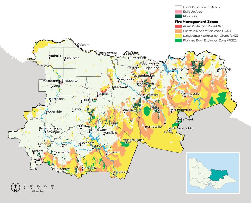
Hume    5

2019/20 Black Summer
bushfires in Hume
In Hume, below average rainfall and underlying            These fires caused significant impacts:
dryness resulted in an early start to the bushfire        damage and disruption across tourism,
season across the region with a dry lightning             farming, forestry, winemaking and beekeeping.
event causing multiple ignitions on 21 November,          In summary: 189 properties, over 20,000 ha
2019. Additional dry lightning events in late             crops and pasture, 921 ha plantation, 246
December resulted in new ignitions across the             sheds, over 4000 stock losses, 85 beehives,
east of State leading to large campaign fires in          as well as extensive fencing losses. On public
the Hume and Gippsland regions.                           land damage included roads and bridges,
                                                          recreation sites, heritage sites including three
                                                          huts. Extensive areas of immature Alpine
Since 2000, Hume region has been subject
                                                          ash and Mountain ash forest regrowth from
to a series of particularly severe bushfire
                                                          previous recent fires were also impacted,
events in relatively quick succession, some
                                                          leading to the largest reseeding program in
involving significant loss of life and property.
                                                          Victoria, with 5551 ha resown in Hume in areas
Major fire events in the region include: a total
                                                          where the risk of forest loss was highest.
of 1,200,000 hectares burnt in the 1939 Black
Friday fires; more than 503,000 hectares in
the 2003 Alpine fires; 444,000 hectares in the            The Upper Murray - Walwa fire also caused
2006/07 Great Divide fires; and 247,000 hectares          widespread disruptions to power, water,
in the 2009 Black Saturday fires, and 36,000 ha           telecommunications and road networks which
in the 2013 Harrietville fires.                           had immediate and lasting consequences for
                                                          local industries and communities. As part of the
                                                          recovery process and lessons from these fires,
During the 2019/20 Black Summer fires FFMVic
                                                          local communities and industries are working
and the CFA responded to 1596 ignitions in
                                                          with local government and recovery agencies to
Hume , which burnt over 319,401 ha and caused
                                                          focus on future energy security and connectivity
widespread impacts to our communities, the
                                                          across Hume region. This will improve
environment and led to the fatality of one
                                                          community resilience to future emergencies,
FFMVic firefighter. The most significant fires:
                                                          particularly for remote communities that may
Upper Murray-Walwa fire burnt 200,442 ha and
                                                          be cut off during emergencies.
Ovens Abbeyard fire burnt 105,910 ha.

                                    Image 1.       The Upper Murray Walwa fire near Corryong caused
                                                   significant community impacts in Hume region
                                    Photo credit: Bailey McKimmie, FFMVic Hume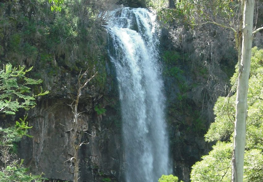
6   Bushfire Management Strategy

    In Victoria, climate change is forecast to:                together include building an understanding of risk
    • extend the bushfire season                               in our area, sharing information through community
                                                               and social channels, developing, practicing and
    • make bushfires larger, more severe, and more
                                                               implementing plans to protect what is valued most
      frequent
                                                               by the local community.
    • make days with an elevated fire danger rating
      more frequent                                            Resilient communities prepare better for bushfires.
    • extend the area that experiences extreme                 They provide the volunteer workforce essential in
      weather conditions, increasing the frequency             the response phase, and they are better able to face
      of these for communities that may have never             the acute shocks and stresses of a bushfire and to
      or have only infrequently experienced such               recover after it.
      conditions
                                                               Victoria’s ‘shared responsibility’ approach
    • start the bushfire season earlier, with more             recognises that communities:
      bushfires starting in spring (which may also
                                                               • are best-placed to understand and mitigate
      change fire weather conditions that are
                                                                 their risks and drive preparedness and recovery,
      experienced, such as wind speed and direction)
                                                                 including through their fundamentally important
    • further strain available resources and capacity            volunteer contribution
      as the bushfire season increasingly overlaps with
                                                               • have knowledge, expertise, capability and diverse
      suitable weather periods for planned burning.
                                                                 perspectives to work with agencies to mitigate
    The impacts of climate change on fire-sensitive              bushfire risk
    habitats and refugia for plants and animals will           • have networks and relationships that help
    become increasingly important to manage.                     agencies identify and protect the things
                                                                 communities value, improve their capacity and
    With climate change making many extreme weather              create meaningful, sustainable solutions.
    events more frequent and more extreme, the
    impacts on communities are also likely to increase.        The shared responsibility approach seeks to ensure:
    Of 15,700 disasters between 1980 to 2015, 91% were         • the interests, values and expectations of
    weather related, and 51% of fatalities and 79% of            stakeholders in, or members of, communities
    economic losses were caused by weather related               are understood and considered in the planning
    extremes1.                                                   process
                                                               • ownership of the planning process and
    Our shared responsibility to mitigate
                                                                 responsibility for implementing strategies are
    bushfire risk                                                broadly shared.
    While bushfires will always be a threat, Victorians        Shared responsibility does not mean equal
    have demonstrated their ability to work together           responsibility: there are some areas where land
    to plan and deliver activities on public and private       and fire management agencies are better-placed
    land to mitigate bushfire risk. As with all areas of       and have more resources and information to
    emergency management, supporting communities               make decisions and act on them. Equally, while
    to be safer and more resilient is the shared               agencies develop plans and implement programs
    responsibility of all Victorians, not just of government   for mitigation, planning, preparedness, response
    agencies. To best manage bushfires, it is important        and recovery, governments or agencies cannot
    that communities and government organisations              guarantee that bushfires will be consequence-free
    come together to understand bushfire risk, agree           for the community. Communities and individuals
    on strategies, and then work both individually and         have the responsibility to prepare their own plans,
    collaboratively to fulfil their individual and shared      properties and assets to reduce the impact of
    responsibilities.                                          bushfires. During major bushfires with far-reaching
                                                               consequences, land and fire agencies may not
    Actions that agencies are responsible for include
                                                               always be able to coordinate and deliver the support
    issuing fire danger warnings and advice, reducing
                                                               the community may expect.
    fuel through planned burning and mechanical
    treatments, commissioning bushfire science
    research, and recruiting and training firefighters.
    Actions that community members are responsible
    for include developing and practising a bushfire
    plan, fully extinguishing campfires, preparing their
    property, and participating in community bushfire
    preparedness activities and events. Actions we do

    1 Department of Home Affairs, 2018
Hume 7
Recognising the role of
Victoria’s Traditional Owners
The Hume region recognises the Victorian
Traditional Owner Cultural Fire Strategy, which
aims to re-establish cultural fire with Traditional
Owner led practices across Victoria, so Traditional
Owners can heal Country and fulfil their rights
and obligations to care for Country. The Victorian
Traditional Owner Cultural Fire Strategy provides a
set of principles and strategic priorities to facilitate
greater self-determination for Traditional Owners
and a framework for effective Traditional Owner-led
cultural fire management in Victoria. The strategy
has an important role in informing the Joint Fuel
Management Program (JFMP) in consultation with
individual Traditional Owner groups. Traditional
Owners emphasise that cultural fire is applied to
achieve culturally meaningful objectives, but that
risk reduction is often a complementary outcome.
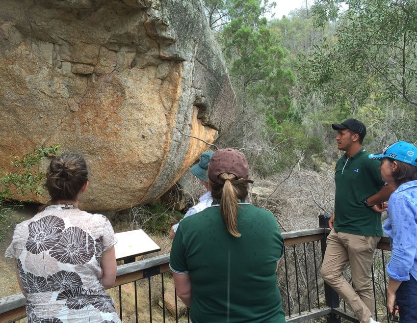
Hume region has important cultural heritage sites like Yeddonba art site within Chiltern/Mt Pilot National Park.
Photo credit: DELWP Hume.
8   Bushfire Management Strategy

                                     Strategic planning
                   Considers                            Focuses activity like planned burning
                   long-term timeframes                 and mechanical works in the most
                   (10-40+ years)                       effective places to reduce bushfire risk

                   Large geographic
                   scales                                 Output = Bushfire Management Strategy

                               Operational planning
                                                        The Joint Fuel Management Program identifies
                   Medium term                          many fuel management activities – planned burning
                   time frames                          and mechanical works – within the strategy area

                   Determines how
                                                        Output = Programs of planned burns,
                   the strategy will be
                                                        mechanical works and engagement
                   implemented to
                                                        over one to three years
                   contribute to the
                   strategic objectives

                                       Tactical planning
                        Short timeframes across                         Output = detailed output
                        small land units                                about how a burn or
                                                                        activity will be conducted
                                                                        to meet objectives.

                         Describes how an individual burn
                         or fuel management activity will
                         be implemented to meet objectives
                         eg. lighting patterns, ignition time,
                         fuel moisture parameters

Figure 1.   Bushfire management strategic, operational and tactical planning for fuel management
Hume 9
Bushfire management Operational and tactical
planning planning
Bushfire management planning occurs at different This bushfire management strategy informs the
levels, with varying time frames, focuses and development of operational plans, primarily the
outputs. Figure 1 shows fuel management planning Joint Fuel Management Program (JFMP). The JFMP
at strategic, operational and tactical levels. is the three-year rolling statewideprogram of fuel
management works on public and private lands
Strategic planning carried out by Forest Fire Management Victoria
(FFMVic) and Country Fire Authority (CFA) to reduce
The strategic planning process identifies where bushfire risk and to maintain the health of native
important values and assets are located across plants and animals that rely on fire to survive. Works
the landscape. It considers the current extent and include planned burning, slashing, mowing and
quality of these values and where possible considers clearing works, creating and maintaining fuel breaks,
future trends including population, industry and and carrying out maintenance on fire infrastructure
environmental change. Strategic planning identifies (like fire dams and lookout towers).
objectives for the important values and assets,
This strategy does not directly address tactical
and develops an approach to manage the risks
(burn) planning, which is done for individual burns.
posed to them. The resulting bushfire management
Tactical planning can include individual burn
strategies describe landscape zones that focus
objectives, community engagement plans and how
fuel management activities to deliver bushfire risk
the burn will be delivered safely.
reduction and ecological outcomes.
Strategic bushfire management planning takes Other bushfire management
place within a legislative and policy context which
includes: actions
• the Emergency Management Act 2013, which This Bushfire Management Strategy outlines our
requires from 1 December 2020 the Emergency risk-based approach to fuel and ecological fire
Management Commissioner to prepare a state management. However, fuel management is not
emergency management plan and to approve the only bushfire management action that reduces
eight regional emergency management plans. bushfire risk and is not always the most effective
In combination with the municipal emergency action to reduce that risk. Fuel management needs
management plans, these provide for an to be supported with other actions for a number of
integrated, coordinated and comprehensive reasons:
approach to emergency management. The Act
also requires emergency management plans to • Some parts of the landscape have inherently high
contain provisions providing for the mitigation of, levels of bushfire risk which requires more actions
response to and recovery from emergencies and to reduce that risk
to specify the emergency management roles and • The ability to reduce risk through fuel
responsibilities of agencies management may be limited in some landscapes
• the Conservation Forests and Lands Act 1987, and there will always be fuel re-accumulation
which requires the Department of Environment, • The effectiveness of fuel management may be
Land, Water and Planning (DELWP), through reduced under extreme weather conditions
the Code of Practice for Bushfire Management • Fuel management reduces fire behaviour, it does
on Public Land (2012), to develop a risk-based not eliminate bushfire. Suppression activities are
approach to bushfire management on public always required to control bushfires.
land. This document meets the requirements set
out in the Code of Practice to prepare a strategic Table 1 lists some key actions that agencies and
bushfire management plan. communities undertake together to manage
• Safer Together: A new approach to reducing bushfire risk and complement our fuel management
the risk of bushfire in Victoria (2015), a Victorian approach.
Government policy, focuses on how effective
As with fuel management, these actions are guided
our actions are in reducing risk and not just the
by bushfire risk analysis combined with other
amount of activity we undertake.
information to ensure they are most effective.
Strategies and plans for these actions are developed
through emergency management planning
processes by agencies at the state, regional and
municipal levels.10 Bushfire Management Strategy
Table 1. Bushfire management approaches beyond fuel management
Approach Key actions
Reduce bushfire • Education and advertising campaigns (e.g. campfire safety, reporting ignitions)
ignitions through
prevention • Coordinated, risk-based patrolling
activities
• Deterrence for deliberate or negligent ignition – laws/prosecution
• Monitoring arsonists
• Restrictions – fire danger period and total fire ban triggers, duration and
restrictions (including legislative change)
• Reducing ignitions from powerlines
Increase the • Fire detection (towers, aerial surveillance)
effectiveness of fire
suppression • Resourcing, capacity and capability of fire-fighting resources (fire crews,
contractors, incident management teams)
• Aircraft fleet management: type, distribution, availability and pre-determined
dispatch
• Road infrastructure including maintenance of the strategic fire access road
network and network of fuel reduced areas.
• Other fire response infrastructure maintenance including remote water access
and helipads
• Fire readiness including rostered and pre-formed IMTs and fire crews
Reduce bushfire • Planned burning based on tenure-blind risk
spread and severity
• Strategic breaks and burn unit boundary standards
• Flexible delivery of burning (e.g. managed bushfire, unbounded burns)
• Other forms of fuel management (e.g. slashing, spraying, mulching) particularly in
high-risk areas where planned burning is not suitable
• Identify and effectively manage fuel hazard reduction on private bush
Reduce the physical • Domestic property preparedness in towns, including fire prevention notices,
effects of bushfires penalties and cost recovery
in inhabited areas
• Vegetation management on public and private land within or immediately
bordering towns including implementation of fire prevention notices
• Identification, prioritisation and treatment of risk to critical infrastructure
• Access and egress (roadside vegetation/tree maintenance) pre- and post-fire
• Asset protection (on-ground)Hume 11
Approach Key actions
Reduce the social • Bushfire education programs targeting vulnerable communities including those
effects of bushfires with identified at-risk or changing demographics, and/or where bushfire risk
on communities cannot be effectively reduced through planned burning.
• Recovery planning and relationship building pre-bushfire (e.g. via community
groups, scenario events and activities)
• Municipal emergency and/or bushfire plans
• Warnings and advice messaging
• Personal and neighbourhood bushfire plans
Reduce impacts • Community engagement about fire management and smoke impacts
from fire
management • Planning to minimise impacts on biodiversity, cultural heritage and other values
actions
• Connections between planning and delivery (e.g. on-ground staff aware of
biodiversity/cultural sites and mitigation actions)
• Cross-tenure planning and consultation
• Monitoring effectiveness of mitigations (and subsequent improvement)
CFA and SES conduct Bushfire education programs across Hume. Mohyu fire and emergency day, 2017
Photo credit: Karen Herbert, FFMVic Hume12 Bushfire Management Strategy
Integrated actions support
fire suppression
We undertake fire management actions using
an integrated approach across detection, fire
response, access roads and fuel breaks, and
fuel management. Together, these actions
provide fire management agencies the best
opportunity to safely, rapidly and effectively
control and supress bushfires when they occur.
Detection and response to new fire ignitions is
critical to keeping fires small. A network of 16
Fire Lookout Towers are staffed throughout the
bushfire period in the Hume region enabling
rapid and accurate detection of fires across
vast areas of the Region that may otherwise go
undetected until they reach a size where first
attack may be compromised. The fire lookout
network is supplemented by scheduled aerial
detection flights on days of high fire danger or
heightened ignition risk. In recent years other
detection mechanisms have been successfully
utilised within Hume including remote
sensing via satellites and this is being rapidly
enhanced as technology progresses.
If a fire is detected, then response is enacted in
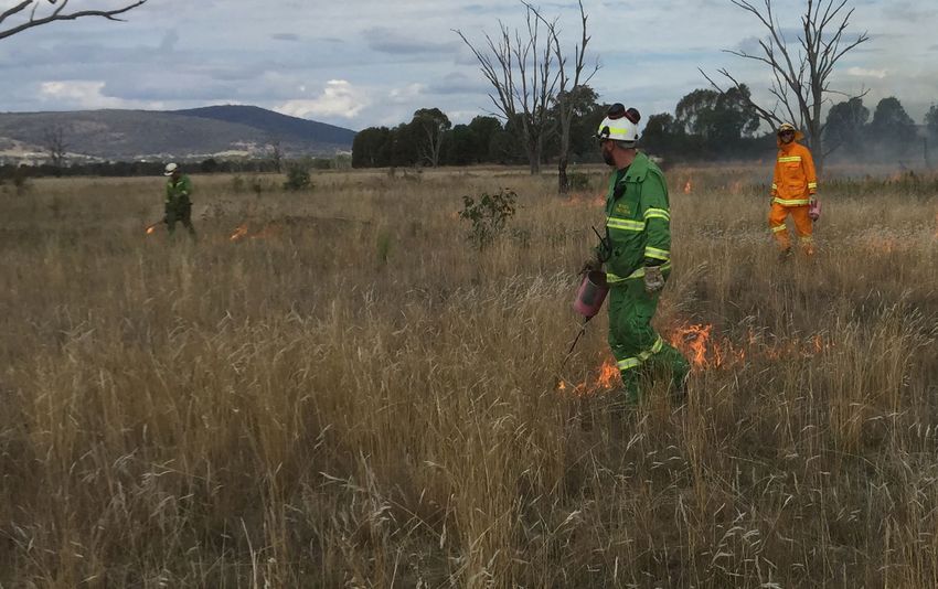
line with existing response plans and a unique Image 2. Integrated fire response
Hume Region Model of Response which outlines
Air and ground attack, along with fuel management, access
the minimum number of resources required to and detection systems provide fire agencies the best chance
be despatched to the ignition on public land. of controlling fires. Terip Terip fire, Gobur Nature Conservation
This model is comprehensive and covers all Reserve, 2018.
types of resources for frontline firefighters, Photo credit: Tom Goldstraw, FFMVic Hume
appliances, heavy plant and machinery,
support resources and aircraft. The scale For many years the Hume Region has worked
of the response is variable dependant on a hard to identify and manage a number of
number of factors including fire danger rating, strategic breaks across the landscape that
forecast lightning activity level and other fires can be quickly utilised in the event of a
in the landscape. Specialist Rappel crews are bushfire. These breaks are complemented
also available to be deployed to remote or by the delivery of broadscale fuel reduction
difficult fires via helicopter to either undertake burns with a particular emphasis on public/
direct first attack or gather intelligence to help private land interface and the creation of
develop appropriate suppression strategies. access tracks along these boundaries that
are managed in an on-going capacity by the
relevant landholder.Hume 13
Our common understanding of our values and of
About this bushfire bushfire risk will underpin ongoing development
management strategy of future strategies and enable agencies to work
together to reduce risk (such as by informing Joint
Victorian landscapes, environments and Fuel Management Planning and Municipal planning,
communities are diverse and multifaceted, and Hume CFA’s engagement treatment plan for
Victorian communities have diverse values, high-risk communities and Hume’s readiness and
preferences and priorities. This regional bushfire response arrangements).
management strategy reflects our region’s unique
environments and communities. To develop this The strategy is a supplement to the Hume Regional
strategy, we undertook a regional planning process Strategic Fire Management Plan 2011 - 2021,
that was guided by the knowledge and priorities developed by the Hume RSFMPC, and applies to
of experts, stakeholders and community members the same Hume emergency management region
from Hume region. footprint. The plan’s agreed vision, strong leadership
and greater cooperation between agencies
Between November 2017 and September 2019, promotes greater community resilience through
representatives of CFA, DELWP, Parks Victoria effective engagement and best-practice integrated
(PV), Emergency Management Victoria and local fire management planning.
governments engaged in a strategic bushfire
risk management planning process. The process Regional emergency management plans and
was guided by the Hume Regional Strategic Fire municipal emergency management plans are being
Management Planning Committee, through the prepared in line with the new amendments to the
regional Safer Together Coordinating Committee Emergency Management Act 2013. This strategy will
and Working Group. They offered opportunities to help inform the bushfire components of these plans,
stakeholders and the broader regional community now and into the future.
to be involved in the planning process through both
For the purpose of the Code of Practice for Bushfire
in-person and online mechanisms.
Management on Public Land (2012), the FFMVic
The strategic planning process resulted in two Chief Fire Officer has approved the public land
strategies to reduce bushfire risk and maintain components of this strategy: specifically, where the
ecosystem health: together, they comprise this strategy relates to state forests, parks administered
strategy — the Hume Bushfire Management under the National Parks Act 1975 and protected
Strategy 2020. public land. These components of the strategy
will directly guide FFMVic’s fuel management
The individual strategies are: operations. This strategy replaces the former
• our fuel management strategy, which focuses on Strategic Bushfire Management Plans for public
reducing bushfire fuels through planned burning land, published by DELWP and PV in 2014 and 2015,
and mechanical works (mowing and slashing) on which used bushfire risk landscape footprints.
public land
• our Bushfire Risk Engagement Areas (BREAs),
which focus on targeted community engagement
to complement, inform and drive fuel
management and other risk mitigation activities
on public and private land.
Our bushfire management strategy focuses on:
• reducing the risk of bushfires threatening lives,
homes, the environment and other important
values and assets across the landscape
• maintaining or improving the resilience of
ecosystems
• establishing a shared understanding of bushfire
risk across the sector, based on the latest science
and the extensive knowledge of agency personnel
• using a 40-year horizon, so long-term ecological
changes and fuel accumulation rates can be
considered in annual operational planning
processes.14 Bushfire Management Strategy
never be completely eliminated. Bushfires will still
Method overview occur, and we must all be prepared and ready to
This document presents the outcomes of the respond. However, bushfire risk can be reduced with
strategic bushfire management planning process. a high-quality risk management approach.
The planning process involved considerable The planning process followed the principles
community engagement — with individuals, of structured decision making (SDM). SDM is a
private land managers, businesses, community framework that helps people unpack complex
organisations and other stakeholders — to tap into decisions, navigate trade-offs and make logical
their knowledge, understand their priorities, discuss and transparent choices. It provides a means of
and evaluate options with them and prepare to bringing together both scientific information and
involve them in implementing the strategy. human values to make decisions, through analysis
and inclusive deliberation. The principles of SDM
In the planning process, we: are particularly useful in decision-making contexts
• identified the values and assets that are most characterised by uncertainty, multiple stakeholders
important to the residents of and visitors to the and competing objectives. Broadly, the SDM steps
region: we grouped these into human life, health included understanding the landscape context,
and relationships, critical infrastructure and setting objectives, identifying possible management
environmental values. strategies, and estimating and analysing the
consequences and inherent trade-offs of these
• developed regional objectives: the things we want strategy options. We then selected the strategy
to achieve by implementing the strategy that gives the greatest benefit to the things we
• combined local knowledge, bushfire behaviour care about, while balancing the impacts of fuel
modelling, historical data and the best-available management actions on those same values.
science to understand how bushfires behave
in our region and to forecast bushfire and fuel In Hume, we developed our strategy through an
management strategy impacts on our most inclusive, comprehensive approach with shared
important and at-risk values and assets decision-making and advice sought across our
• developed and evaluated many potential region. This included the formation of a core
strategies to select two — our fuel management interagency working group and coordinating
strategy and the Bushfire Risk Engagement committee, which we used to build a holistic
Areas (BREAs) — that will enable agencies and engagement approach including workshops with a
communities to best mitigate bushfire risk to the wide range of experienced agency representatives
region’s most important and at-risk values and and committees, targeted stakeholder meetings, an
assets. active and interested external community reference
group and a range of community conversations
The planning process was underpinned by the including events, meetings and engagement surveys.
International Standard for Risk Management ISO
31000. The standard acknowledges that risk canHume 15
Bush camping is popular particularly in summer, Howqua valley near Mansfield. DELWP Hume
Photo credit: DELWP Hume
We also used a new 20-year historical weather
Identifying and assessing risk to dataset for Victoria to identify recent changes to
values and assets the state’s climate and so we could better model
the average frequency with which various weather
To identify the region’s most important values and scenarios occur. This provided some indication of
assets, we consulted with our partners, stakeholders the likelihood of these scenarios occurring in future.
and communities, and we drew on specialised data We also partnered with climate scientists to forecast
sets including the Victorian Fire Risk Register – various climate conditions relevant to bushfires
Bushfire (VFRR-B) and Victorian Biodiversity Atlas. which will inform future strategic bushfire risk
management planning and preparedness decisions.
We used Phoenix RapidFire, which is world-leading
bushfire simulation software developed in Victoria, Our planning process considered outcomes for flora,
to model the spread of a bushfire from an ignition fauna and ecological communities. We modelled
point under the specified weather conditions. This these ecological outcomes for a range of possible
enables us to understand the impact bushfires could fuel management scenarios. To predict fauna and
have on people, homes and other important values TFI outcomes, we drew on modelling that sits within
and assets in our landscape. We modelled ignitions the Fire Analysis Module for Ecological values
and bushfire spread patterns at thousands of places (FAME) including Habitat distribution models. This
throughout the region: module was designed for this purpose by the Arthur
• using the bushfire characteristics information in Rylah Institute and the University of Melbourne. We
the ‘Bushfire history and patterns’ section also drew on decades worth of flora, fauna and
ecological data collected in Hume as well as newer
• under a range of bushfire weather conditions,
modelling tools.
including Code Red conditions: a Forest Fire
Danger Index (FFDI) rating of 130 or above. These
were the conditions in many parts of the state on
Black Saturday 2009, and conditions were similar
at times during the 2019–20 fire season. Code
Red conditions are also forecast to become more
frequent and more extreme with climate change.16 Bushfire Management Strategy
Sandstone fire near Cambarville, 2019.
Photo credit: Tom Goldstraw, FFMVic Hume
Our landscape context
The Hume region (Figure 2) makes up 20% (4.5 million ha) of Victoria’s land area, with
over 1.65 million ha (21.4%) of this area located on public land. It stretches northward
from the fringe of Melbourne to the Murray River and westward from the alpine areas
of the Great Dividing Range to the floodplains and grasslands of the Goulburn and
Murray rivers. The Hume region is home to more than 320,000 people and four formally-
recognised Aboriginal Traditional Owner groups.Hume 17 Figure 2. The Hume region with local government boundaries and public land tenure
18   Bushfire Management Strategy

     Local government profiles
     The communities of the Hume region are represented by 12 councils, with three large population
     centres: Shepparton, Wodonga and Wangaratta.

           Mitchell Shire Council                               Rural City of Wangaratta
           (population 40,918)                                  (population 28,310)
     Mitchell Shire Council is a growth area              The Rural City of Wangaratta is centred on
     for Melbourne experiencing substantial               the city of Wangaratta, which is Victoria’s
     development and an expanding population,             tenth largest. Industries in the area include
     which is anticipated to grow from 40,000 to          agriculture, transport and health. The northern
     270,000 people in the next 25 years. The area        part of the local government area consists of
     consists of farmland and rolling foothills, and it   plains and hills bisected by the Ovens River.
     includes Beveridge, Wallan and Kilmore.              The southern area is foothills and ranges.

           Greater Shepparton City Council                      Moira Shire Council
           (population 63,387)                                  (population 29,112)
     Located on the Goulburn River, the area is a         Located on the Murray River, the shire has
     vibrant, diverse municipality about two hours        several settlements including Cobram,
     north of Melbourne. There is a substantial           Nathalia and Yarrawonga as well as major
     manufacturing base along with farming and            food and tourism industries. The area was
     a thriving food production industry. Notable         subjected to a major flood impact in 2010–11,
     enterprises include Furphy and Sons, Visy, SPC       with recovery continuing in many areas.
     Ardmona and Tatura Milk Industries.
                                                                Benalla Rural City Council
           Murrindindi Shire Council                            (population 13,681)
           (population 13,732)
     Including the towns of Alexandra, Yea,               Benalla is 193 km north of Melbourne, and it
     Marysville and Eildon, Murrindindi Shire is an       is home to industries including value-adding
     area the industries of which include agriculture     for timber production, a major defence
     and viticulture, forestry and tourism. Much of       components manufacturer and agriculture.
     the shire is subject to substantial bushfire risk,   Other features include its location on the
     due to towns abutting extensive forest and           Hume Highway and the Melbourne-to-Sydney
     bushland. The area was severely damaged by           rail line, and it is also the home of the State
     bushfire in the 2009 Black Saturday fires.           Gliding Centre.

           Mansfield Council                                    Towong Shire Council
           (population 8,584)                                   (population 5,985)
                                                          The municipality of Towong is one of Victoria’s
     Tourism and agriculture are the key industries       remotest local government areas, being
     for this area, which also is home to two of          located in the far north-east of the state.
     Victoria’s key skiing areas: Mt Buller and Mt        Settlements include Corryong and Tallangatta,
     Stirling. The area includes the headwaters of        and the area is home to agriculture,
     several important water systems including            tourism and forestry (including extensive
     the Delatite, Howqua, Jamieson and Goulburn          softwood plantations) industries. Much of
     rivers.                                              the municipality, particularly Cudgewa and
                                                          Corryong were severely impacted by the
                                                          2019–20 fires.
Hume 19
Alpine Shire Council Wodonga City Council
(population 12,337) (population 39,351)
The main towns are Bright, Myrtleford and Mt The local government area is one of the
Beauty, and the area has mountain ranges smallest in the Hume region, but it is a major
and foothills along two main river valleys. Key population centre with a range of industries
industries are agriculture and tourism, and the including Mars Petcare food manufacturing,
area features the ski resorts of Mt Hotham and Woolworths distribution centre – Greenfreight
Falls Creek. A substantial area of public land at Barnawartha; and it hosts the Bandiana
including Mt Buffalo was impacted or under Military Area and Wodonga TAFE La Trobe
threat by the 2019-20 fires. University. Wodonga City Council is anticipating
significant future growth, and it is the fastest-
growing municipality in north-east Victoria.
The area has a long history of large fires
with the shire affected in 1985, 2003, 2006/07
and 2013. The 2019-20 fires also impacted a Shire of Strathbogie
substantial area of public land including Mt (population 10,781)
Buffalo, and threatened local communities.
Strathbogie Shire enjoys excellent transport
linkages via the Hume Freeway, Goulburn
Indigo Shire Council Freeway and Melbourne – Sydney railway line.
(population 15,952) In part as a result of these strategic transport
links populations in the areas of Nagambie,
Home to the historically significant towns of
Avenel and Strathbogie Ranges have been
Beechworth, Rutherglen and Chiltern, the area
steadily increasing. A feature of the area is
also has important viticulture, agriculture and
vegetated rising hills in the south which have
tourism industries.
areas of forest and bushland that are long
unburnt and of environmental significance.
The area has important tourism and Important industries include wineries, tourism
agriculture industries including viticulture and and farming.
apiary. The towns are also known for their
evidence of the gold rush era, with landmarks
and relics throughout the areas. The shire has
experienced fires with significant fires in 2003
and 2009. the 2003 Alpine fires.
Important regional economies in Hume include the wine and tourism industries. Pictured a vineyard in the Alpine Valley.
Photo credit: DELWP Hume20 Bushfire Management Strategy
Bushfire history and patterns
Hume region has a long history of large and intense
fires, some involving significant loss of life and
property. Major fire events in the region include
a total of 1.27 million ha burnt in the 1939 Black
Friday fires, more than 503,000 ha in the 2003
Alpine fires, 444,000 ha in the 2006–07 Great Divide
fires, 247,000 ha in the 2009 Black Saturday fires,
36,000 ha in the 2013 Harrietville fire and 320,120 ha
in the 2019–20 Black Summer fires (Figure 3).
Since 2000, the region has been subject to a series
of particularly severe bushfire events in relatively
quick succession. These fires have affected many
thousands of hectares of public and private
land and had significant social, economic and
environmental impacts.
The risk of bushfire is widespread across our
landscape. In the northern and western parts of
the region, fires are often fast-moving, wind-driven
grassfires that are generally contained within 24
hours, despite sometimes covering large areas. In
the southern and eastern areas, the steep, long
and heavily forested slopes of our landscape mean
fires are generally slower, intense and difficult to
suppress. These fires in the difficult terrain of the
Great Dividing Range, High Country and Central
Highlands have impacts not only for Hume region
but for landscapes, communities and regions to the
south and east of Hume. Significant fires have also
entered the Hume region from fires in NSW.
Responding to more than 1,000 ignitions a year,
fire management agencies in Hume see extreme
contrasts in ignition patterns and fire behaviours
that require a variety of suppression strategies.
More than 80% of ignitions in the Hume region occur
on private land, and 20% of these are caused by
lightning.
Hume region has a long history of bushfires. Pictured, Mt Buffalo
fire in 1985, burnt 51,400 hectares.
Photo credit: Archival photo, DELWP HumeHume 21 Figure 3. Bushfire history for the Hume region, 1980–2020
22   Bushfire Management Strategy

     Values and assets                                                      Critical infrastructure

     Here we describe the most important features of our                    National, state and regionally significant
     landscape that informed our strategy.                                  infrastructure include nationally important high-
                                                                            voltage powerlines and power stations, major
                                                                            transport corridors (such as the Hume Highway and
     Human landscape                                                        the Melbourne-to-Sydney rail line), major road links
                                                                            with limited alternative routes (such as the Great
     The region comprises 12 local government areas
                                                                            Alpine Road), and mobile, internet and television
     — Mitchell Shire, Murrindindi Shire, Mansfield Shire,
                                                                            communications networks including aircraft
     Greater Shepparton City, Moira Shire, Strathbogie
                                                                            communications towers (Figure 4).
     Shire, Benalla Rural City, Wangaratta Rural City,
     Alpine Shire, Indigo Shire, City of Wodonga and                        The critical infrastructure identified was
     Towong Shire — and four Alpine Resort Management                       considered to be particularly important for bushfire
     Boards — Mount Hotham, Mount Buller-Mount                              management, as it underpins the region’s social and
     Stirling, Falls Creek and Southern (Lake Mountain                      economic functions. Disruption to our infrastructure
     and Mt Baw Baw). Unlike other regions, there is                        and communications networks impacts essential
     no single, dominant regional city. Hume’s main                         services, industries, the economy and our community
     economic sectors include tourism, plantation timber                    connections. This was recently evident during the
     and native hardwood resources, and agriculture.                        2019–20 season, when significant disruptions to
                                                                            power, water, telecommunications and road networks
     Human life, health and relationships                                   had immediate and lasting consequences for local
                                                                            industries and communities, including impacts
     The Hume region is home to more than 320,000
                                                                            on wellbeing from the emotional toll of significant
     people, with the population distributed across the
                                                                            isolation caused by these disruptions.
     landscape in small settlements and agricultural
     areas and in the main settlements of Alexandra,                        The Hume region has nationally significant water
     Benalla, Beechworth, Bright, Corryong, Eildon, Euroa,                  catchments and storages, which provide almost
     Seymour, Shepparton, Mansfield, Wangaratta,                            40% of the inflows into the Murray-Darling river
     Wodonga and Yarrawonga. People are more                                system and supply water for irrigation districts and
     dispersed in the west of the region, where the                         hydro-electric power generation. These large water
     topography is much flatter. In the east of the                         storages are also important tourism destinations
     region, settlements are mostly located along the                       and include Lake Eildon, Lake Mulwala and Lake
     river valleys. Visitation and seasonal populations                     Hume. Catchments in the Central Highlands also
     swell in the summer periods, particularly in the                       provide drinking water for Melbourne.
     riverine areas of the west including around the
     Goulburn and Murray rivers and in the Alpine
     valleys: particularly in Bright, Mt Beauty/Tawonga,
     Harrietville, Eildon and Mansfield, which are popular
     tourist destinations.

        Water catchments and storages like Lake Eildon are important for power generation, irrigation, tourism, recreation and our environment.
                                                                                                    Photo credit: Tom Goldstraw, FFMVic Hume
Hume 23 Figure 4. Critical infrastructure, assets, systems and networks in the Hume region
24   Bushfire Management Strategy

     Regional economy                                        resorts and along the Murray River. The region is
                                                             also home to large forestry operations, with Alpine
     The Hume region is extremely varied in its              and Mountain Ash timber currently harvested from
     industry and employment make-up, with a strong          state forests, and soft and hardwood sourced from
     concentration of agricultural industries in the west,   managed plantations. The region’s forested areas
     and the Alpine wine and gourmet food areas in           also support a significant apiary industry. The region
     the east making a strong contribution to regional       is the main gateway to Sydney from Melbourne, with
     employment. Tourism is an important industry for        Wodonga a major ‘twin-city’ border community
     the region, particularly in and around the Alpine       (Figure 5).

     Figure 5.    Generalised land use in the Hume region
Hume 25
Crews working to protect Dibbins Hut in the Alpine National Park during the 2013 Harrietville fire.
Photo credit: Parks Victoria
Historic heritage Aboriginal cultural heritage
Our region’s non-Indigenous history dates back Our region’s history stretches back thousands
to the 1820s when cattlemen across the Central of generations and includes the use of fire by
highland and High country built their rough Aboriginal people for environmental, economic
huts, some of which still stand. In the early 1850s, and social purposes. Our region has thousands
people (many from China) flocked to the region — of Aboriginal cultural heritage sites including
particularly to the Alpine valleys, the High Country ceremonial gathering places, shell middens, burial
and the Chiltern and Rutherglen areas — to look for sites, scar trees, artefact scatters, stone quarries,
gold. Many heritage sites remain from this period rock shelters and art sites. We work with cultural
including gravesites, mining relics and diggings. heritage specialists, Aboriginal Victoria and
European settlers first inhabited the forested hills Traditional Owners to manage and protect these
on the northern fringes of Melbourne in the 1860s, important sites.
followed closely by paling splitters and then timber
cutters who camped deep in the bush. Our region The Hume region is home to three formally
also includes many relics from these periods recognised Aboriginal Traditional Owner groups;
including bush huts, sawmills, sawdust heaps, the boundaries of a fourth Traditional Owner
tramways and timber trestle bridges. group — the Gunaikurnai Land and Waters
Aboriginal Corporation — abut a small area of
the region in the Alpine area. The Registered
Aboriginal parties (Traditional Owners) across our
area are Taungurung Land and Waters Council,
the Yorta Yorta Nation Aboriginal Corporation
and Wurundjeri Woi Wurrung Cultural Heritage
Aboriginal Corporation (Figure 6).26 Bushfire Management Strategy
Figure 6. Traditional Owner groups in the Hume region
Note: the remainder of Eastern Maar’s RAP application is still being considered and may in future include additional area in the landscape.Hume 27
Image 3. Bindaree falls in Mansfield State Forest
Photo credit: Lucas Russell, FFMVic Hume
Vegetation communities change dramatically from
Natural landscape west to east across the region, following a distinct
Hume region’s 1.65 million ha public land estate rainfall and elevation gradient. In the west, there
is comprised of a network of parks and reserves are floodplains of grasslands and woodlands; the
and state forest, which is built upon the national landscape then becomes undulating and foothill
criteria for a comprehensive, adequate and forest; in the east are tall, wet montane forests, with
representative (CAR) reserve system of Australia’s snow gum woodlands and grassy alpine meadows
forests (Figure 7). Parks and reserves are primarily on the higher mountain ranges. Several of these
managed for nature conservation, ecosystem vegetation communities are sensitive to fire regimes,
services and recreation. State forest is managed for and along with several flora and fauna species are
a greater diversity of purposes including biodiversity listed under the Flora and Fauna Guarantee Act 1988
conservation, water catchment services, timber and the Environment Protection and Biodiversity
harvesting, firewood production, cattle grazing, Conservation Act 1999. The flatter part of the region
minor produce and apiary use. Recreation and in the west has been more extensively cleared for
tourism are also important and increasingly popular agriculture and settlements, compared to the east,
uses of state forest, with many active and passive which remains largely forested. Several river valleys
pursuits commonplace across the region. Alpine run in a north-west-to-south-east direction, the
resorts are also key areas of public land in the region most significant of which are the Mitta Mitta, Kiewa,
and are important areas for tourism, recreation and Ovens, King, Broken and Goulburn valleys.
biodiversity conservation.28 Bushfire Management Strategy
Figure 7. Native vegetation by land tenure in the Hume regionHume 29
Managing natural values in Hume;
Bogong High Plains
The Bogong High Plains is the most extensive Alpine Sphagnum Bogs and Associated Fens
tract of alpine and sub-alpine vegetation in (Alpine Peatlands) are listed as endangered
Victoria. It is habitat for threatened reptiles, and are protected at a National and State
amphibians, fish, mammals (including the level. Alpine Peatlands are highly sensitive
Mountain Pygmy-possum) and home to many to disturbances such as fire and are slow to
threatened species that are only found in recover. They contribute to plant and animal
restricted areas. diversity and provide significant benefits to
the environment: storing carbon and filtering
out sediments, nutrients and pathogens from
The endangered Mountain Pygmy-possum is
water. In addition, bogs add organic carbon
protected at a National and State level. They
to water which underpins the food chain in
are restricted to alpine and subalpine areas in
mountain streams.
south-eastern Australia, including fragmented
populations in the Bogong High Plains, where
habitat includes high elevation boulder In Hume and Gippsland regions, DELWP and
fields with associated shrubby heathlands, PV partnered with other States and agencies
typically above 1200m. These heathlands are to improve management of 4086 ha of Alpine
vulnerable to bushfire and planned burning, Peatlands in Eastern Victoria, aiming to reduce
with other major threats to the species the impacts of fire and fire control activities
including the isolation and fragmentation of by informing fuel management planning (such
these populations, introduced predators and as fire management zones and planned burn
climate change (which is predicted to increase frequency) and using better fire response
bushfires). Careful planning is required during techniques near Alpine Peatlands during
suppression activities and planned burning in bushfire response. This includes detailed
these area to avoid any negative impacts of fire mapping of Alpine Peatlands that can be used
to Mountain Pygmy-possums and their habitat. to inform management decisions, for example
keeping use of bulldozers and fire retardants
away from peatlands, or directing water drops
to protect them from fire.
Image 4. The endangered Mountain Pygmy- Image 5. Endangered Alpine Peatlands are
Possum is found only in restricted highly sensitive to fire and other
restricted alpine areas including disturbances
the Bogong High Plains
Photo credit: Glen Johnson, DELWP Hume Photo credit: Dan Jamieson, Parks VictoriaYou can also read