ORRORAL VALLEY FIRE RAPID RISK ASSESSMENT NAMADGI NATIONAL PARK - RAPID RISK ASSESSMENT TEAM
←
→
Page content transcription
If your browser does not render page correctly, please read the page content below
ORRORAL
VALLEY FIRE
RAPID RISK
ASSESSMENT
NAMADGI
NATIONAL PARK
RAPID RISK ASSESSMENT TEAM

Environment, Planning and
Sustainable Development Directorate

March 2020
© Australian Capital Territory, Canberra, 2020
Information contained in this publication may be copied or reproduced for study, research, information or educational
purposes, subject to appropriate referencing of the source.
This document should be cited as:
ACT/NSW Rapid Risk Assessment Team – February 2020. Orroral Valley Fire Rapid Risk Assessment Namadgi National Park.
Unpublished report. Environment, Planning and Sustainable Development Directorate. ACT Government, Canberra.
ACT Government website www.environment.act.gov.au
Telephone: Access Canberra 13 22 81

Publishing: 20/0197

ACKNOWLEDGEMENT
We acknowledge the Traditional Custodians of the Canberra region, the Ngunnawal people, and pay our respects to their
Elders, past and present.
We acknowledge and respect their continuing culture and the contribution they make to the life of this city and this region.
We acknowledge the deep connections Traditional Custodians have with the lands and waters now known as Namadgi
National Park, and their ancestral and ongoing legacy to ‘Care for Country’.
We acknowledge that Namadgi National Park contains a rich cultural landscape, with the Aboriginal history of the region
dating back over 25,000 years. The cultural values of the area are maintained through oral tradition, dance, memory,
ceremony, art and stories; and are also found in tangible heritage sites such as ceremonial sites, rock art sites, cultural
trees and artefact scatters.
We acknowledge that, as caretakers of the region, the Ngunnawal people hosted large ceremonies for neighbouring
nations, for ceremony, Lore, marriage, trade and the sharing of cultural knowledge. These nations included the Wiradjuri
(to the west), Wolgalu (to the south), Yuin (to the east), Ngarigo (to the southeast) and Gundungurra (to the north); and we
recognise these connections.

DISCLAIMER
This report documents the process and outcomes from a rapid post-fire risk assessment and is not intended to be a
comprehensive report. It has been prepared for Commissioner Georgina Whelan and the Orroral Valley fire Incident
Management Team, the ACT Conservator of Flora and Fauna, the Environment, Planning and Sustainable Development
Directorate and ACT Parks and Conservation Service for the purposes of rapid risk assessment following a fire event. A
representative sample of assets at risk has been surveyed based on fire severity mapping, recommendations are based on
best available knowledge from Agency representatives.
The report is provided to other Agencies for the purposes of information only (it is not intended as being fully
comprehensive or final and follow-up assessment will be required). Agencies other than the ACT Parks and Conservation
Service rely on this report at their own risk and should obtain their own advice.
Risk assessment is inherently a dynamic process of risk identification, risk analysis and risk evaluation. The risk
assessment in this report is based on the best information available throughout the term of the deployment.
This report is prepared as part of the 12 to 17 February 2020 deployment of the Rapid Risk Assessment Team to the Orroral
Valley fire.
Front cover: Upper Cotter Catchment, Feb 2020, Nathan Kay.

2      Orroral Valley Fire Rapid Risk Assessment Namadgi National Park
CONTENTS

PURPOSE OF THE REPORT..............................................................................................................4
THE RAPID RISK ASSESSMENT TEAM......................................................................................4
ACKNOWLEDGMENTS........................................................................................................................5
EXECUTIVE SUMMARY...................................................................................................................... 6
SUMMARY OF THE FIRE.................................................................................................................... 6
CONSIDERATION OF CLIMATE CHANGE.................................................................................7
2003 CANBERRA BUSHFIRES........................................................................................................7
LANDSCAPE SCALE OPPORTUNITIES POST FIRE.............................................................7
COMMUNITY ENGAGEMENT.......................................................................................................... 8
RAPID AREA ASSESSMENT TEAM............................................................................................. 8
   RRAT Objectives..................................................................................................................................................................8
   RRAT Methodology...........................................................................................................................................................8
   Fire Severity Methodology..........................................................................................................................................9
DISCIPLINE ASSESSMENT.............................................................................................................. 13
   Flooding and Erosion.................................................................................................................................................... 13
   Assets..........................................................................................................................................................................................19
   Heritage...................................................................................................................................................................................24
   Biodiversity – Fauna........................................................................................................................................................ 31
   Biodiversity – Flora.......................................................................................................................................................... 37
   Fire Rehabilitation..........................................................................................................................................................45
GLOSSARY...............................................................................................................................................47
REFERENCES.........................................................................................................................................48

Rapid Risk Assessment Team                                                                                                                                                                              3
PURPOSE OF THE REPORT
This Rapid Risk Assessment Team report documents the rapid risk assessment completed in 5 days on the Orroral Valley
fire within Namadgi National Park. The report was undertaken as soon as possible after the fire event to support land
managers to mitigate immediate risks.
The report scopes the scale and nature of emergency stabilisation, rehabilitation and recovery works emphasising
impacts on built, cultural and environmental assets. It identifies and assesses potential risks to life and property,
infrastructure and the environment and provides initial recommendations for initial risk mitigation.
This report will inform and contribute to the development of rehabilitation and recovery plans.

THE RAPID RISK ASSESSMENT TEAM
TABLE 1. ACT/NSW RAPID RISK ASSESSMENT TEAM

Discipline                               Name                            Agency
Team Leader                              Margaret Kitchin                Strategic Coordination and Planning
                                                                         Transport Canberra and City Services

Deputy Team Leader                       Kristy Gould                    ACT Parks and Conservation

NSW Deputy Team Leader                   Andrew Boleyn                   NSW National Parks and Wildlife

Biodiversity                             Wade Young                      ACT Parks and Conservation

Biodiversity – Flora                     Nathan Kay                      ACT Parks and Conservation

Biodiversity – Fauna                     Renee Brawata                   Conservation Research
Terrestrial and Aquatic

GIS Specialist                           Jen Smits                       Conservation Research

Assets                                   Allan Bendall                   Asset Data Integration
                                                                         Transport Canberra and City Services

Flooding and Erosion                     Tom McElroy                     ACT Parks and Conservation

Heritage                                 Meaghan Russell                 ACT Heritage
Aboriginal and Historic

Logistics and Report Coordination        Luke Bulkeley                   ACT Natural Resource Management

Fire Rehabilitation                      Scott Seymour                   ACT Emergency Services Agency

Fire Recovery                            Julian Seddon                   Conservation Research

4      Orroral Valley Fire Rapid Risk Assessment Namadgi National Park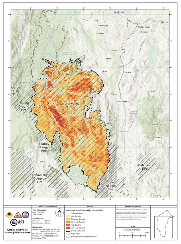
ACKNOWLEDGMENTS
The Rapid Risk Assessment methodology and assessment techniques are based on those developed by the Victorian
Department of Environment, Land, Water and Planning Bushfire Rapid Risk Assessment Team (Bushfire RRATs) and their
prior work is fully acknowledged.
The following people and organisations assisted in the development of this Orroral Valley Fire Rapid Risk Assessment:
Greg Baines, Matt Beitzel, Neil Cooper, Peter Cotsell, Mark Elford, Lisa Evans, Scott Farquhar, Chris Glennon, Justin Foley,
Brian Hawkins, Adam Henderson, Amanda Johnson, Leanne Kaleb-Dumic, Adam Leavesley, Brian Levine, Brett McNamara,
Michael Mulvaney, Oliver Orgill, Stephanie Pulsford, Laura Rayner, Louisa Roberts, Melissa Snape, Steve Taylor, Deklyn
Townsend, Ian Walker, Claire Wimpenny – Environmental Planning & Sustainable Development Directorate ACT
Steve Forbes, Rebecca Hughes, Rick McRae, Erik Sandin, Ludzia Szychowska, Richard Verkuylen, Kate Waghorn, Georgina
Whelan – ACT Emergency Services Agency
Gabrielle Caddy, Fiona Moore – ACT Heritage
Daniel Goodwin, Anthony Haraldson, Sue Marriage – Transport Canberra & City Services
Tim Chaseling – ICON Water
Simon Hemer, Carl Hollis – NSW National Parks & Wildlife Service
Wally Bell – Buru Ngunawal Aboriginal Corporation
Adrian Brown – King Brown Tribal Group
Bruce Ford – Significance International
Graeme Hirth
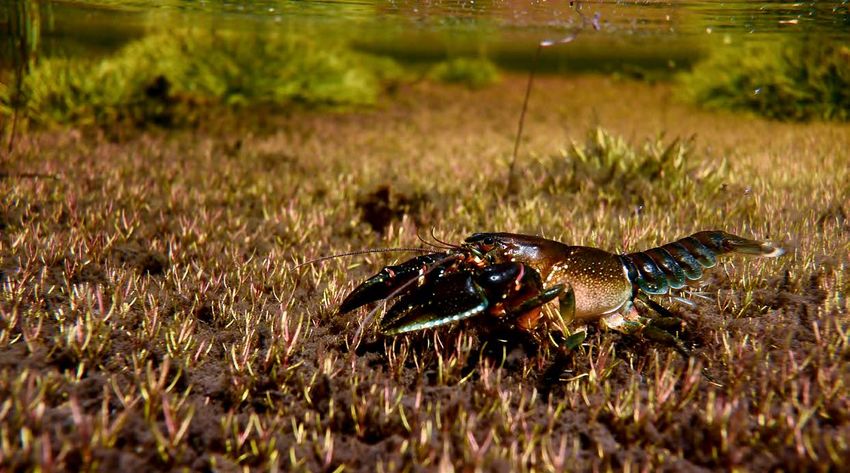
Reiks Crayfish, Mark Jekabsons
Rapid Risk Assessment Team 5
EXECUTIVE SUMMARY
The Orroral Valley fire burnt 87,923 ha in the ACT with extensive areas in Namadgi National Park (NNP) comprising the
southern region of the Cotter Catchment. The area overlapped with large areas burnt in 2003. Over the burn area, 22%
was estimated to be burned at a high to very high fire severity resulting in impacts due to fire, smoke and earthworks, plus
post-fire impacts including debris flows and soil erosion.
The EPSDD has been involved in past ACT/NSW Burned Risk Assessment Team (BAAT) deployments and decided to
deploy an ACT-lead team, now called the Rapid Risk Assessment Team (RRAT). These team undertake a very rapid risk
assessment of the burned area utilising staff in the Agency and taking a ‘learning by doing’ approach. The team was led by
ACT and NSW staff who had deployed with the BAAT previously.
A team of 13 people were combined over five main disciplines of cultural heritage, flora, fauna, flooding and erosion and
assets. A specialist in fire rehabilitation also worked with the team. The team began a five-day deployment on 12 February
2020, completing the deployment with a presentation to the Emergency Services Agency (ESA) and the Land Management
Agency (EPSDD) on Tuesday 18 February 2020.
The RRAT team identified 27 key risks across the burn area. This included 9 extreme, 14 high and 4 medium risks. Broadly
the key risks centred around:
> Extreme (9) being:
    • Direct impacts on cultural heritage (rock art, sites, huts)
    • Risks to public safety (roads and walking tracks, visitor nodes from trees)
    • Impacts on biodiversity (Alpine bogs)
    • Threats to biodiversity (predation, feral herbivores, invasive spp.)

> High (14) being:
    • Risks to biodiversity (fish – water quality, Large gliders, threatened flora and fauna, fire-sensitive communities,
      hollow-bearing trees, aquatic and riparian habitat)
    • Risks to cultural heritage (timber sites, stone arrangements, archaeological sites)
    • Water quality – water catchments (sediment)
    • Hillslope erosion
    • Assets – fencing and visitor infrastructure (needing repair)

Mitigation treatments were considered, and initial recommendations compiled. These are indicative only, based on the
information available at the time of the deployment. Many of the mitigation treatments are for the initial assessment of the
work so that a full recovery plan can be scoped and programmed. Monitoring of the work undertaken and its effectiveness
in treating the risks should be part of all implementation.
NNP is a place of exceptional cultural heritage and biodiversity significance. Much of the Orroral Valley fire area has now
burnt twice in 20 years – its recovery is in all our hands.

SUMMARY OF THE FIRE
The Orroral Valley fire started at 1:49pm in grassland on Monday 27 January 2020 in Namadgi National Park(NNP). The fire
spread approxmately 2,581 ha in the first 24 hours driven predominantly by topography and exceptionally dry forest fuel
loads. Over the next 3 days the fire size grew approximatley 4,500 – 8,000 ha per day extending to remote and inaccessible
wilderness within NNP.
On Saturday 1st February under extreme fire danger the fire grew by approximately 26,000 ha, spreading predominatly
southeast. This included exiting the southeastern border of the ACT at Clear Range.
Approximately 78% of NNP was burnt during the fire, totalling over 82,700 ha. This included impacts across the Cotter River

6       Orroral Valley Fire Rapid Risk Assessment Namadgi National Park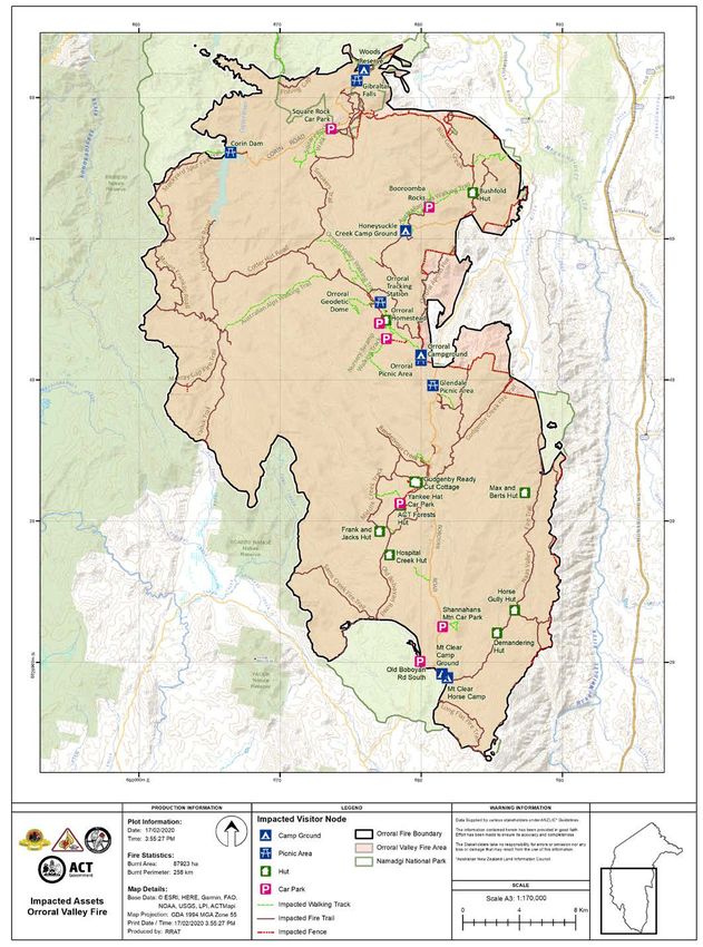
Catchment, ACT’s primary water supply. The fire also spread into Tidbinbilla Nature Reserve (TNR) with 1,444 ha burnt,
22% of the reserve.
Fire intensity varied including significant areas of very high severity with consumption of all ground fuels and tree crowns.
At the time of the RRAT deployment significant areas of High Country Bogs and Associated Fens threatened ecological
community have been impacted by the fire.
Suppression operations and rain across the fireground (~158 mm between 10 and 14 February) led to containment at
approximately 88,000 ha.

CONSIDERATION OF CLIMATE CHANGE
In evaluating risks and potential recovery actions, the RRAT were aware of the need to consider long-term viability of
environmental, cultural and built assets in the context of a changing climate. Climate change projections for the fire
affected area of NNP and TNR are for an increase in mean temperatures and changes in the seasonality, intensity and total
amount of rainfall. Climate change is expected to increase the average Fire Danger Index (FDI) and the number of severe
fire danger days in the future. These changes will influence both the post-fire recovery of biodiversity values and long-term
viability of some species.
As the RRAT process is rapid in nature and focuses on initial recommendations and immediate actions, future climate
change trajectories for the assets impacted were not considered in the assessment. The RRAT recommends that detailed
recovery planning and programming of works by the land managers further consider climate change projections to ensure
recovery efforts are effective and likely to be viable in the long term. The Agency could consider a conceptual framework
on climate change risks to environmental assets and values, to produce a consistent and transparent approach to the
future management of these under changing climate scenarios.

2003 CANBERRA BUSHFIRES
This Orroral Valley fire 2020, occurred 17 years after a large wildfire which burnt 90% of NNP in 2003. The 2003 fire
occurred in January and February and covered 164,914 ha approximately 70% of the ACT including TNR, the Lower Cotter
Catchment and impacting the urban fringe of the city (Cary et al., 2003). The geographic extent and severity of the 2003 fire
was unprecedented. Differentiating the 2020 Orroral Valley fire is that it did not make a major progression into the Bendora
catchment (the middle catchment of the Cotter River Catchment).
Some of the actions discussed in this RRAT report consider the interval between the 2003 and the 2020 fires. For example,
Alpine Ash is recorded to require at least 20 years between fires to enable maturation of trees to produce seed set.
Similarly, areas of the Sphagnum bogs and fens have been burnt twice in 17 years. Consideration of recovery and actions
will need to take this recent fire history into account.

LANDSCAPE SCALE OPPORTUNITIES POST FIRE
Any fire provides the opportunity for further learning and understanding. Fire has long been part of the Australian
landscape and post-fire research, surveys and monitoring provide further information about how our plants, animals and
communities respond to fire, as well as being an opportunity to access areas or see locations that are otherwise covered
by vegetation or inaccessible.
For example, during the Orroral Valley fire, fire suppressant gel was utilised in the Gibraltar Rocks and Mount Clear areas.
It is not clear how the unique environments of the ACT will respond to this; further monitoring and assessment could be
considered.
Following the 2003 fires a large amount of new information was generated. The Australian Alps National Parks co-
operative management program undertook and have published on-line several post-fire reports, similarly the State
and Territory Agencies as well as the Universities. The Orroral Valley fire presents the opportunity to undertaken further
research and monitoring on key questions and management challenges, including landscape response to successive fires.

Rapid Risk Assessment Team                                                                                                     7
COMMUNITY ENGAGEMENT
Canberra’s community, interest and user groups including industry are key stakeholders with a strong affinity to NNP.
Collectively they have formed a critical partnership with the Environment Division supporting park operations and
research. Engaging the community through the recovery process and reconnecting people with Namadgi will greatly
assist recovery actions.
To assist with recovery, a volunteer Fire Assist Program will be established. The Program will be focused on recovery
assistance objectives and operate within the existing volunteer assist hub. An EPSDD communications campaign will
allow for effective and informative community messaging about progress and Park access as areas become safe to use. As
recovery volunteer opportunities are identified the community will be invited to use the volunteer assist hub to be directly
involved. For example, the Canberra Bushwalkers Group will be an important resource to assist with trail audits and basic
trail rehabilitation.
To facilitate reopening of both Namadgi and Tidbinbilla, a comprehensive audit will be undertaken to ensure visitor nodes
and infrastructure is safe. A risk assessment of tracks, trails, toilets, picnic areas, BBQs, campgrounds, drinking water,
gates and fencing will be prioritised with a view to open areas as soon as possible. Pending outcomes, some areas may
remain closed temporarily. Clear signage, barriers and succinct communication with the community will ensure users are
well informed of areas open to access.
TNR sustained relatively minimal damage to the high use areas. An immediate priority will be to ensure toilets, BBQs and
shelters are safe for use. Priority will also be given to returning wildlife and the reopening of the Sanctuary, Mt Gibraltar,
Cascades and Lyre Bird trails. For the Namadgi area, priorities will be to reopen the visitor centre and walks immediately
adjacent to the centre. Progressively walks and campgrounds throughout the Park will be assessed, restored and
reopened.

RAPID AREA ASSESSMENT TEAM
RRAT OBJECTIVES
Recovery is an integral component of fire management. Fires cause both immediate impact and potential post fire future
risksand impacts. The immediate impacts, driven by fire severity, location and topography can generate many future risks
such as erosion, landslips or soil movement. All of these future risks can be exacerbated by storms and flooding. While
built infrastrucutre, like roads and builidings are often affected by these secondary impacts, endangered species, sensitive
ecological communities and habitats can be impacted too.
The rapid assessment of these risks and identification of mitigation actions after high intensity fires can significantly
reduce risks to public safety, infrastructure and the environment.
The ACT/NSW interagency RRAT (previously BAAT) is a 6-12 person multi-disciplinary team who undertake rapid risk
assessment of impacted areas. The team works largely on public land to assess risks to life, property, infrastructure and
the environment, develop mitigation options, and prepare a report for land managers to consider and action. The team
does not assess property loss and destruction.

RRAT METHODOLOGY
The Team consists of a Leader and Deputy, plus specialists in flooding and erosion, asset management, cultural heritage,
flora, fauna and GIS spatial analysis. The primary data sources for the team are satellite remotely sensed imagery before
and after the fire that provide fire severity, modelled erosion risk potential and local databases and data sets that provide
asset information (e.g. Threatened species and communities, Integrated Asset Management System (IAMS), vegetation
communities etc).
After an initial briefing from the Incident Controller about the fire, the team collated information on the assets, how they
may have been impacted by the fire, identified what threats remained and what were the potential triggers for these
threats. Examples of these are rainfall, visitation and invasive species. Using the asset, threat and trigger information,

8      Orroral Valley Fire Rapid Risk Assessment Namadgi National Park
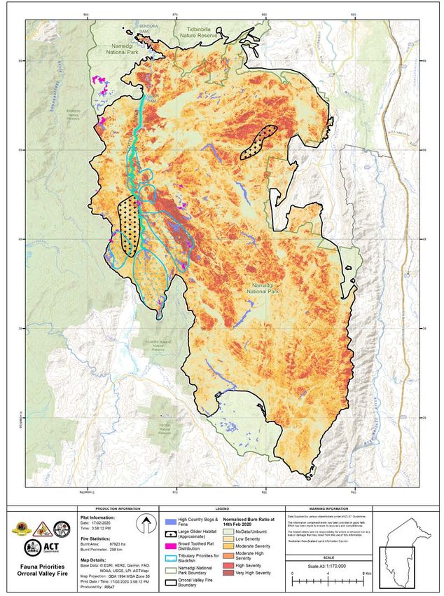
a risk assessment based on consequence and likelihood was derived and the priority risks identified. The ACTIA risk
assessment tables were used for the assessment of risk ratings.
An automated risk assessment tool was used to enter possible mitigation options and how these could reduce the
residual risk. Risks across all RRAT disciplines were amalgamated where appropriate in a risk moderation process (e.g.
flooding & erosion risks to infrastructure). Mitigation treatments for risks identified as extreme and high were then more
fully detailed. Information was compiled into a report and a presentation made at the end of the deployment.

FIRE SEVERITY METHODOLOGY
The fire severity map was generated by comparing pre and post-fire satellite imagery using the normalised difference
burn ratio index (nBDR) (Map 1: Orroral Valley fire). The reflectance values of selected electromagnetic wavelengths are
used to determine the change in greenness of vegetation before and after the fire and the level of change corresponds
to fire severity which is mapped as six distinct classes. Capture dates were: Pre fire - 16/12/2019; Post-fire – 4/2/2020 and
15/2/2020. The satellite imagery was captured via Sentinel, at a 20 meter pixel size.
Validation of the severity mapping was carried out by assessing severity classes from helicopter flown on 11/2/2020 via
the sampling of approximately 100 points across the burn area. Given the need to undertake a rapid assessment of the
fireground, the imagery used occurred when the fire was still burning so some areas have a slight smoke impact and did
not cover the full fireground. Utilising this imagery was the only option for producing a fire severity product at the time
of the RRAT deployment. The fire severity package will be updated when a clear, cloud free image is available and can be
used to inform future works.
TABLE 2. FIRE SEVERITY CLASSES

Severity Classes                         Criteria
Very High                                Consumption of all or majority of the leaves, exposed soil

High                                     Complete scorch of leaves

Moderate-High                            Mixed loss of canopy, scorched leaves, burnt understorey

Moderate                                 Mixed scorched leaves

Low                                      Majority unburnt or green canopy

No class                                 Unburnt, smoke affected or unmapped

Rapid Risk Assessment Team                                                                                                      9
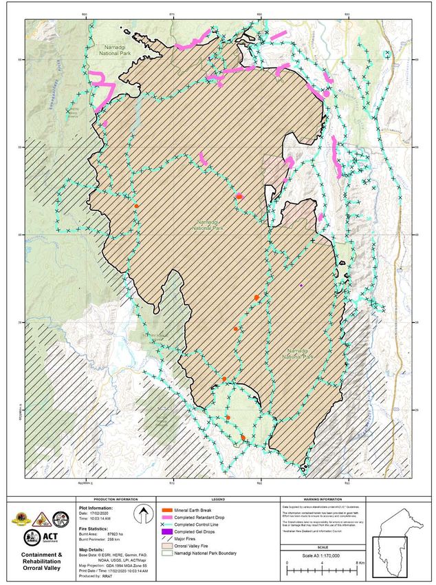
MAP 1: ORRORAL VALLEY FIRE NAMADGI NATIONAL PARK

10   Orroral Valley Fire Rapid Risk Assessment Namadgi National Park
TABLE 3. ORRORAL VALLEY FIRE RISK TABLE

             Value or Asset                                                                                                                                                                                                       Treated    Treated     Residual
Theme                              Threat                          Trigger                   Result of threat                  Risk      Proposed Risk Treatment
             at Risk                                                                                                                                                                                                              Likelihood Consequence risk
Fauna        Threatened Fauna      Post fire predation from        Fire impact               Loss of threatened species        Extreme Address targeted pest control in prioritiy areas for threatened fauna populations that     Possible   Moderate        Medium
             populations -         introduced predators                                      populations, reduced ability to           are highly vulnerable to increased risk of predation post fire (i.e. Broad-toothed Rat
             predation                                                                       recolonise burnt areas                    and Reik’s Crayfish).
Fauna        Threatened Fish -     Reduced water quality           Fire impact, high         Loss of key threatened fish       High      Prioritise sedimentation control and riparian restoration around key populations.        Possible   Moderate        Medium
             water quality         from debris, erosion and        intensity rainfall post   populations                                 Consider translocations if emergency response is required.
                                   sedimentation                   fire, reduced water
                                                                   quality
Fauna        Fauna - Large         Direct fire impacts and         Moderate to High fire     Loss of populations               High      Assess known populations in high fire severity areas, survey target areas and plan       Likely     Minor           Medium
             gliders               starvation following fire       severity in known                                                     priority conservation actions as required.
                                                                   population areas
Fauna        Threatened Birds,     Loss of habitat and          Loss of habitat,             "Reduced faunal diversity and     High      Conduct assessment of connectivity within midstory and understory of burnt               Likely     Minor           Medium
             Reptiles and Small    fragmentation of populations particularly hollow          potential loss of populations"              patches. Explore possible supplementary habitat provision or other actions to assist
             Mammals                                            bearing trees                                                            persistance of vulnerable fauna populations. Involve community volunteers and
                                                                                                                                         citizen science.
Fauna        Theatened             Formation of new instream    High intensity rainfall      "Reduced fish passage and loss    Medium    Conduct prioritised field assessment to identify high risk areas and any barriers to fish Rare      Insignificant   Low
             Fish - habitat        barriers resulting in        and movement of              of populations"                             passage. Remove barriers as required.
             fragmentation         fragmentation of populations debris
Cultural     Aboriginal heritage   Direct fire - heat and smoke    Fire impact and           Loss of and damage to             Extreme Condition assessments by rock art specialist, materials conservator and                    Possible   Major           High
Heritage     - rock art sites      impacts; indirect impacts       subsequent rainfall       Aboriginal rock art                       Representative Aboriginal Organisations to identify additional management actions.
                                   from physical and chemical      and erosion                                                         Undertake any immediate stabilisation works. High priority - undertake as soon as
                                   changes, increased erosion                                                                          possible.
Cultural     Aboriginal and       Damage to heritage values        Earthworks at known       Damage to heritage features       Extreme Inspection of affected areas by an archaeologist and RAOs, salvage of displaced            Almost     Moderate        High
Heritage     historic heritage -  due to construction and          and potential heritage    and deposits                              artefacts for recording and analysis under approved Statement of Heritage Effect.          Certain
             archaeological sites rehabilitation of earthworks     sites                                                               High priority - undertake as soon as possible.
Cultural     Historic heritage -   Damage to historic huts         Fire impact               Loss of heritage values           Extreme Condition assessment of Demandering Hut and Max and Bert Oldfield's Hut by                 Likely     Major           High
Heritage     high country huts     from fire. Damage to historic                                                                       heritage specialist to identify any additional management actions needed. Install
                                   fabric.                                                                                             temporary fencing prior to park reopening. Medium priority - undertake within 3
                                                                                                                                       months.
Cultural     Aboriginal and        Loss of heritage trees          Moderate to very high     Loss of cultural heritage         High      Includes scarred trees, survey marker trees, and brumby yards. Condition                 Possible   Moderate        Medium
Heritage     historic heritage     (standing/fallen) due to fire   fire severity areas                                                   assessements by archaeologist, including arborist and RAOs for Aboriginal cultural
             - timber heritage     impacts. Health impacts that                                                                          tree inspections. Identify any additional management actions. Medium priority -
             sites                 shorten tree life.                                                                                    undertake within 3 months.
Cultural     Aboriginal            Exfoliation and spalling of     Fire impact and           Damage to and displacement of High          Condition assessments by archaeologist and RAOs. Identify any additional                 Possible   Moderate        Medium
Heritage     heritage - stone      stone from fire. Indirect       potential post-fire       heritage fabric                             management actions needed. High priority - undertake as soon as possible.
             arrangements          impacts from increased          erosion
                                   erosion
Cultural     Aboriginal heritage   Damage to heritage values       Fire impact and           Damage to heritage places, loss   High      Condition assessements of known sites by archaeologists and RAOs. Identify any           Possible   Minor           Medium
Heritage     - archaeological      due to erosion and soil         potential post-fire       of archaeological context and               additional management actions needed. Medium priority - undertake within 3
             sites                 movement                        erosion                   information                                 months.
Cultural     Historic heritage -   Damage to historic huts,        Fire impact               Loss of heritage values           Medium    Condition assessments for select built heritage sites where condition is unknown.        Possible   Moderate        Medium
Heritage     built heritage        homesteads and structures.                                                                            Identify any additional management actions.
                                   Damage to historic fabric
Flora        Alpine Bogs and       Loss of vegetation community Fire impact                  Loss or degradation of            Extreme Commence assessment of sphagnum bogs immediately with focus on loss of habitat             Possible   Moderate        Medium
             associated fens       and associated habitat and                                sphagnum and associated                   for threatened fauna species particularly the Broad-toothed Rat and Northern
                                   function                                                  community, erosive incising               Corroboree Frog. Undertake rehabilitation and recpvery program as a priority.
                                                                                             impacting water retention and             Funding reflects initial 3 years of the program.
                                                                                             filtering
Flora        Native plants         Invasive plant introduction     Fire severity and        Invasive plants outcompeting       Extreme Monitor invasive plant encroachment prioritising control lines, retardant lines, key       Likely     Minor           Medium
             and ecological        (new species) and               extent, fire suppression native species, modification of            access nodes and disturbed soils. Timely implementation of control programs as
             communities -         encroachment (existing          activities               native ecological communities              required. Response consistent with EPSDD biosecurity strategies. High-risk species
             invasive plant        species)                                                                                            include African Lovegrass, Nodding Thistle, Hawkweeds, Coolatai Grass, Broom, and
             impacts                                                                                                                   Ox-eye Daisy. Funding reflects initial 3 years of the program.

11      Orroral Valley Fire Rapid Risk Assessment Namadgi National Park
Value or Asset Treated Treated Residual
Theme Threat Trigger Result of threat Risk Proposed Risk Treatment
at Risk Likelihood Consequence risk
Flora Threatened species Vertebrate pests Increased access Direct impacts include digging, Extreme Feral herbivores represent a significant threat to flora and fauna populations post fire, Likely Minor Medium
and ecological following fire trampling, wallowing, browsing particularly to threatened species, ecosystems and vegetation communities of high
communities – feral (particualry horses and and track formation. Indirect sensitivity. Address vertebrate pest encroachment prioritising species and habitat
herbivores deer), green pick from impacts on water quality with species for control (i.e. horses, deer, pigs, rabbits). Funding reflects initial 3 years
regenerating plants through damage to riparian of the program.
ecosystems.
Flora Threatened and Loss of threatened plants and Fire severity, extent, Localised extinction, increased High Commence assessment of fire impact on EPBC and Nature Conservation Act listed Possible Moderate Medium
significant plant communities and interval. Changing pressure from invasive plants species and ecological communities. Develop post-fire monitoring and management
species - sites climate and vertebrate pests, native plan for long-term viability. Funding reflects initial 3 years of the program.
fauna grazing
Flora Fire-sensitive Loss of species and Fire impact, fire Localised extinction, fire below High Includes Snow Gum, Alpine Ash, Callitris, Black Sallee, and Large-flowered Tea Possible Moderate Medium
vegetation vegetation communities interval and severity. the tolerable fire interval, Tree. Assess fire impacts on all communities and develop management response
communities Changing climate increased pressure from where required. Commence monitoring regime where considered appropriate.
invasive plants and vertebrate Implement future fire management planning to consider long term viability of these
pests communities.
Flora Large hollow- Loss of habitat Fire impact Loss of significant habitat High Undertake habitat tree assessment in key habitat for protected fauna species. Likely Moderate High
bearing trees Development management actions. Consider nest boxes and tree hollow construction
and research into other innovative options.
Flooding/ Roads and walking Erosion and/or sediment Rainfall events and Loss/damage to road and Extreme Assess individual roads that fall within the high risk zone (where roads/trails intersect Possible Moderate Medium
Erosion tracks deposition impacting road subsequent erosion walking track infrastructure with high burn severity or key riparian zones); temporarily close roads where access is
infrastructure and debris flows in not critical; install erosion and sediment controls above roads at risk. Costings reflect
moderate to high burn intial assessment only.
severity areas
Flooding/ Water quality Water impacted by sediment Moderate to significant Reduced total source water High Hillslope erosion control on priorty areas in the Cotter River catchment, per erosion Possible Moderate Medium
Erosion and quantity in flows within potable water rainfall events and availability in the ACT, increased risk model, engagement with Icon Water to determine future water management
the Cotter River catchment and dams assosciated sediment water treatment costs approach, including the consideration of specific debris and sediment controls,
catchment flows expansion of water quality monitoring programs. Costings reflect intial assessment
only.
Flooding/ Aquatic and Sedimentation from Rainfall events that Reduced biodiversity, alterered High Protection of riparian vegetation in streams of second order and above, especially Possible Moderate Medium
Erosion riparian habitat in hillslope and gully erosion, increase catchment hydrological flows, increased where such streams intersect with high hillslope erosion and/or debris flow risks, field
priority sites streambank erosion peak discharges catchment flow rates assessments may trigger targeted streambank and bed protection in high priority
sites. Costings reflect intial assessment only.
Flooding/ Hillslopes in Hillslope and gully erosion Rainfall events leading Loss of fertile ashbed and High Install runoff and erosion control measures at high priority sites, per erosion risk map, Possible Moderate Medium
Erosion high erosion to increased runoff in residual native seeds, gully assess roads/culverts likely to increase concentrated flows on high risk hillslopes -
areas - requiring moderate to high burn formation and subsoil loss, implement culvert outlet protections or consider alternative road drainage structures
stabilisation severity areas downslope/downstream that do not capture and concentrate flows. Costings reflect intial assessment only.
sedimentation impacts
Flooding/ Research and Flooding, debris flows, Rainfall events Damage to assets through Medium Coordinate with asset owners/managers from EPSDD, Universities and Icon Water Possible Minor Medium
Erosion monitoring sediment deposition leading to increased direct flood impacts and/or to determine critical, long term water quality and ecological monitoring assets
infrastructure runoff, flooding and sedimentation (e.g. turbidity probes) to be prioritised for protection or restoration, through either
sedimentation targeted sediment control or relocation.
Assets Fire Trails, walking Staff and public safety Fire impact, storm/ Injury or death. Damage to road Extreme Keep areas closed to public until safety works have been completed. Maintain Unlikely Major High
tracks, visitor resulting from falling trees/ wind surface barriers, signage and regular compliance patrols. Arborists to address hazardous
nodes limbs trees. Ongoing monitoring of hazards.
Assets Fencing Stock movement, illegal Fire impact Wandering stock, illegal vehicle High Engage fencing contractors to repair/replace boundary fences within 3 months. Possible Minor Medium
access access causing environmental/ Engage fencing contractors to repair/replace internal fences within 12 months.
asset damage Consider using flame resistant fencing materials.
Assets Visitor Fire impacted infrastructure Fire impact Injury to staff and public, High Keep areas closed to public until safety works have been completed. Assess damaged Unlikely Moderate Medium
infrastructure requiring repair. Staff and damage to infrastructure, infrastructure and remove and rebuild as required. Consider using flame resistant
public safety environmental contamination materials to enhance durability.
Assets Cultural assets (not Damage/destruction of Fire impact, moderate Loss/damage to European Medium Field assessment of European cultural sites. Provide report on future actions and Unlikely Minor Medium
heritage listed - in European cultural sites not to heavy rainfall event cultural sites ongoing costs of management. Consult with ACT Heritage regarding recovery actions
heritage section) registered on the Heritage and ongoing maintenance or reconstruction.
Register
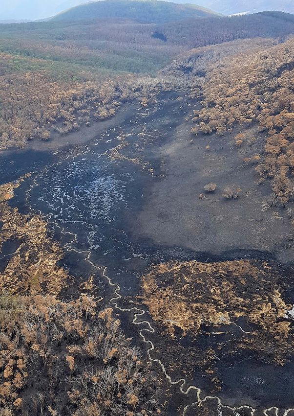
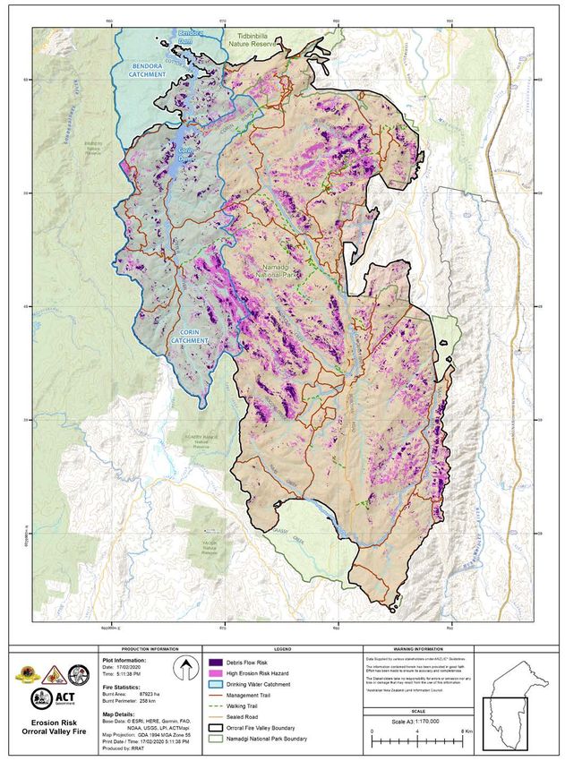
12 Orroral Valley Fire Rapid Risk Assessment Namadgi National ParkDISCIPLINE ASSESSMENT FLOODING AND EROSION DESCRIPTION Fires that burn with high severity are known to considerably increase the likelihood of soil erosion and sedimentation. With the loss of vegetation and litter that protects soil, together with heat-induced changes that reduce soil structural stability, hillslopes and associated drainage systems that are impacted by high severity fire are highly vulnerable to erosion and sedimentation. The burnt area of the Orroral Valley fire within NNP is mostly within upland landscapes at altitudes above 800 metres. Two broad geological units are within the fire area: Ordovician sediments and metasediments (which cover most of the Cotter River catchment) and Silurian granites (which cover the remainder of the burnt area). Soils derived from both these geologies are generally shallow and sandy, with high localised erosion and mass movement risk (Cook 2016). The catchments in NNP have been impacted by the Orroral Valley fire to varying degrees. Within the Upper Cotter catchment, 99% of the Corin dam catchment and 29% of Bendora dam catchment was burnt, though the severity was highly variable in both water storage catchments. Burn severity was similarly variable in the other impacted catchments. METHODS Using spatial and field sourced information, the assessment of the erosion and flooding risk considered the potential impacts on both ecological and infrastructure assets. These impacts and the subsequent prioritisation of mitigation strategies were assessed using the rapid methods below. > Evaluating landscape modelling of hillslope erosion risk at natural, low severity and high severity burn (URS 2009) > Soil landscapes data evaluated to establish erosion risk hazard > Spatial analysis of the extent of catchment and stream/riparian areas impacted by burn severity > Spatial analysis of the intersection of roads and trails with both high hillslope erosion risk hazard and high burn severity > Modelled debris flow risk and its intersection with burn severity (Nyman 2016) > Aerial survey to assess burn severity and extent and to visibly gauge erosion and debris flows on severely burnt hillslopes ASSUMPTIONS AND GAPS The erosion and flooding assessments undertaken were based on the best available spatial data and modelling available at the start of the deployment, with limited field verification. Burn severity, for example, was partially incomplete on parts of the western and north-western burn edge due to smoke and cloud; therefore, spatial modelling of these areas will likely understate erosion risk. The hillslope erosion risk modelling adopted for this assessment may slightly understate erosion risk: while soil cover factors in this dataset are modelled to account for increased runoff, they do not predict complete crown and surface layer vegetative consumption during very high burn severity. Physicochemical changes to soils which may increase their erosive likelihood are also not predicted. The erosion risk hazard model used in this assessment does not quantify sediment flows through catchment systems. 13 Orroral Valley Fire Rapid Risk Assessment Namadgi National Park
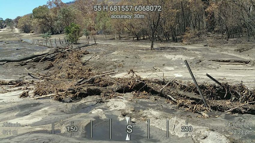
Discipline: Flooding and Erosion

Asset name: Roads and walking tracks

Location: Various locations within burn area

Risk: Extreme

Impact: Loss of, or damage to road and walking track infrastructure

General description
With elevated runoff rates and erosion potential in areas of high burn severity, roads and walking tracks that intersect such
areas within the burn are likely to be impacted by debris flows, mass movement, and sedimentation. At high erosion risk
locations, 3 km of roads and 5 km of walking tracks have been identified, and for debris flow risk, 2.5 Ha adjacent to walking
tracks and 6.5 Ha adjacent to roads have been identified.
A thorough field assessment of these roads and walking trails will determine the damage extent, to develop specific
remediation measures. Where roads and walking tracks intersect highly erodible hillslopes, upslope stabilisation works will
mitigate sedimentation impacts.
Targeted drainage control works will minimise road and track surface erosion issues until surrounding vegetation recovers
and runoff rates and volumes decline.

Initial treatment recommendations
> Assessment of roads and walking tracks that intersect with high erosion risk hazard modelling
> Refer to prescribed management strategies for invasive plants and animals to mitigate riparian vegetation impacts
> Direct stabilisation works, where required

Map: See Map 2 Erosion Risk Orroral Valley Fire
See page 18.

Photo
Sedimentation on Cotter Hut Road, Julian Seddon

Rapid Risk Assessment Team                                                                                                       14
Discipline: Flooding and Erosion

Asset name: Water quality and quantity in the Cotter River catchment

Location: Cotter River Catchment

Risk: High

Impact: Reduced total source water availability; increased water treatment needs

General description
Corin and Bendora Dams are within the Cotter River catchment. The increase in runoff and the subsequent erosion and
sediment flows can impact catchment waterways and each dam. Of the highly erodible landscapes of the Cotter River
catchment, 1951 ha of Corin catchment and 137 ha of Bendora catchment have been impacted by high severity fire. These
areas intersect with 24 ha of buffered waterways, the adjacent hillslopes and riparian areas of which are the priority for
erosion control.
In managing the risk of debris flows into water storages, debris flow barrier systems and sediment boom nets should be
considered. In partnership with Icon Water, engineering and financial scoping of such systems is proposed. Sediment boom
nets could either be installed at the primary stream inputs into each dam, or near water intake points within the reservoirs.
Vegetation losses post fire reduce infiltration and evapotranspiration, leading to increased runoff rates, which in turn
leads to greater catchment water yields. As the catchment recovers, however, water yields reduce as infiltration and
evapotranspiration increase. Additional monitoring of these altering hydrological affects will assist Icon Water in future water
management, including environmental flows.

Initial treatment recommendations
> Undertake hillslope erosion control adjacent to high priority streams, involving the installation of coir logs and felled
  timber contour barriers ($5,920 per Ha)
> In partnership with Icon Water, commission a scoping assessment to determine the practical and financial viability of
  debris flow barriers and sediment boom nets
> Additional monitoring to better manage water quality and quantity impacts of future fire events – partnership between
  Icon Water and EPSDD

Map: See Map 2 Erosion Risk Orroral Valley Fire
See page 18.

Photos
Corin Dam, Tom McElroy                                           Mountains near Bendora Dam, Luke Bulkeley

15    Orroral Valley Fire Rapid Risk Assessment Namadgi National Park
Discipline: Flooding and Erosion

Asset name: Aquatic and riparian habitat protection in high risk sites

Location: All catchments within burn area

Risk: High

Impact: Reduced biodiversity and altered hydrological flows

General description
At a catchment scale, where high burn severity, high erosion risk, and waterways of second order and above intersect,
the likelihood of elevated stream flows and subsequent waterway erosion is increased. This is exacerbated when riparian
vegetation is also impacted by fire.
Relative to catchment area, the Cotter River draining into Corin Dam and the Gudgenby River catchments are the most
impacted by high severity fire. The increased runoff rates in these catchments are, therefore, the most likely to impact the
geomorphic stability of waterways, which can result in wider, shallower and less sinuous stream channels. These changes
directly impact aquatic habitat. An assessment of riparian and waterway condition will determine the need for specialised
streambank and bed stabilisation works, such as bank and bed revetment and sedimentation controls.
The control of pest and invasive plants that could threaten the recovery of riparian vegetation is also a critical component of
habitat recovery.

Initial treatment recommendations
> Detailed survey of the extent of riparian vegetation and waterway condition in high risk sub-catchments
> Refer to prescribed management strategies for pest plants and animals to mitigate riparian vegetation impacts
> Direct stabilisation works, where required

Map: See Map 2 Erosion Risk Orroral Valley Fire
See page 18.

Photos
Sediment deposition adjacent to Cotter River                     Riparian vegetation adjacent to Cotter River
Julian Seddon                                                    Julian Seddon

Rapid Risk Assessment Team                                                                                                        16
Discipline: Flooding and Erosion

Asset name: Hillslope stabilisation in high erosion risk sites

Location: All catchments within burn area

Risk: High

Impact: Gully formation and soil loss; downslope/downstream sedimentation impacts

General description
The erosion risk hazard of hillslopes is directly correlated with the localised severity of the fire and the extent to which
hillslopes are naturally susceptible to erosion. After fire, as surface vegetation that would otherwise capture rainfall is reduced,
the proportion of rainfall that results in overland flow significantly increases. Soil protection measures that reduce runoff and
increase infiltration are proposed, including the installation of coir logs, felled timber barriers and contour furrowing.
Roads are an importing contributing factor to runoff velocities, especially where they capture, concentrate and redirect flows
down susceptible hillslopes. Culverts, for example, can be especially problematic in initiating gully erosion. Prioritisation for
assessment are where roads are situated within 50 metres of streams. Stabilisation works, where required, involve energy
dissipating structures at culvert outlets, and grade control works in gullies.
An assessment will determine the precise extent of the required works.

Initial treatment recommendations
> Install coir logs and other slope length minimisation measures in high priority sites
> Assess the road network to determine where culverts/road drainage are contributing to gully initiation; broadly evaluate
  road design to determine if road drainage generally can be modified to mitigate runoff concentration
> The design and installation of energy dissipators and associated erosion control works

Map: See Map 2 Erosion Risk Orroral Valley Fire
See page 18.

Photos
High severity burnt hillslope                                      Erosion initiated from culvert outlet
Brett McNamara                                                     Julian Seddon

17    Orroral Valley Fire Rapid Risk Assessment Namadgi National Park
MAP 2: EROSION RISK ORRORAL VALLEY FIRE

Rapid Risk Assessment Team                18
ASSETS

DESCRIPTION
NNP is a major recreational destination for the people of Canberra and surrounding NSW. The Orroral Valley fire spread
across most of the park, impacting numerous recreation and management assets including campgrounds, picnic areas,
car parks, walking tracks and fences. All these assets consist of multiple smaller associated assets that also can be
impacted by fire for example shelters, toilets, huts, tables/chairs, bridges, boardwalks, and steps.

METHODS
Assessment of the impact of the Orroral Valley fire on park assets used the following methodology:
> The ACT Parks and Conservation Service (ACT PCS) asset management system was queried to identify all assets
  recorded within the burnt area
> The separate NNP sites of significance GIS data was queried to identify additional sites within the burn area
> Assets were prioritised for field checking by overlaying them with high and very high burn severity
> High priority assets were inspected by helicopter to identify impacts
> Field staff where supplied with the list of assets in the fire impacted area and conducted on-ground inspections and
  returned the information and photos
> Assets were assessed based on fire impact, safety, environmental impact and recreation value to identify the priority
  sites
> Assessment via helicopter was conducted of the priority sites to identify impacted assets and provide risk mitigation
  actions

ASSUMPTIONS AND GAPS
> Assets are assumed to be recorded in the asset management system or sites of significance data
> Burn area mapping is assumed to be accurate
> Burn severity mapping is not complete for the entire fireground
> Not all assets could be inspected on the ground and were visually inspected from the air
> Detailed inspections of individual sites (e.g. walking tracks) was not possible during the deployment
> Not all fencing is mapped. In measuring fence length an assumption has been made that the full length of the NNP
  boundary with neighbouring rural land is fenced
> The treatments for this discipline consider full replacement of the asset, not decommission

DISCUSSION
The burnt area includes several high use recreation facilities highly valued and regularly used by the community. All three
designated campgrounds in NNP are in the burnt area. A structured approach is recommended to quickly assess, make
safe, repair and reopen recreational facilities to the public especially in the higher use sites.

19     Orroral Valley Fire Rapid Risk Assessment Namadgi National Park
Discipline: Assets

Asset name: Fire trails, walking tracks, visitor nodes

Location: Various

Risk: Extreme

Impact: Injury or death, damage to roads, tracks and trails

General description: Risk to public safety from hazardous trees
Fire trails, walking tracks, car parks, picnic areas and campgrounds are the primary areas in NNP used by members of the
public.
290 km of fire trail, 84 km of walking tracks and 19 recognised visitor nodes are within the burn area. Falling trees and limbs
are an extreme risk to life and will need to be mitigated prior to reopening these areas to the public.
All those working in fire affected areas need to consider the risk from hazardous trees to their own safety and the safety of any
others working under their direction.

Initial treatment recommendations
>   Keep areas closed to the public until safety assessments and works have been completed
>   Maintain barriers, signage and regular compliance patrols
>   Identify sites where minimal work is required and prioritise to allow public access
>   Arborists to inspect hazardous trees and make recommendations
>   Ongoing monitoring of hazards will be required, particularly following storm events

Map: See Map 3 Impacted Assets Orroral Valley Fire
See page 23.

Photo
Tree assessment and tree clearing, Boboyan Road
Amanda (AJ) Johnson

Rapid Risk Assessment Team                                                                                                     20
Discipline: Assets
Asset name: Fencing
Location: Various
Risk: High
Impact: Wandering stock, illegal access, environmental/asset damage
General description: Park boundary, public access control and internal fencing
Approximately 120 km of fence line are within the burnt area, 109 km of which are used as boundaries with adjacent rural
land or for access control. These are important for preventing the movement of stock into the national park, restricting the
movement of feral animals and preventing illegal access.
Fences have been damaged by direct fire impact, falling trees and runoff from rain events. Replacement of fencing will
require liaison with adjacent landholders regarding access, fence type and possible consideration of future gate locations.
Responsibility for boundary fences between Government and private managed land varies across the ACT and needs to be
considered for each lease. Significant lengths of fencing require liaison with NSW landholders.
Initial treatment recommendations
> Contractors and staff to consider the risk of hazardous trees prior to works
> Engage fencing contractors to repair/replace damaged sections of fencing in accordance with PCS standards
> Prioritise works along boundaries with agricultural land
> Replacement fencing should comply with current PCS standards to use non-flammable materials such as steel/concrete
posts
Map: See Map 3 Impacted Assets Orroral Valley Fire
See page 23.
Photo
Fence damage from fire and runoff
Scott Seymour
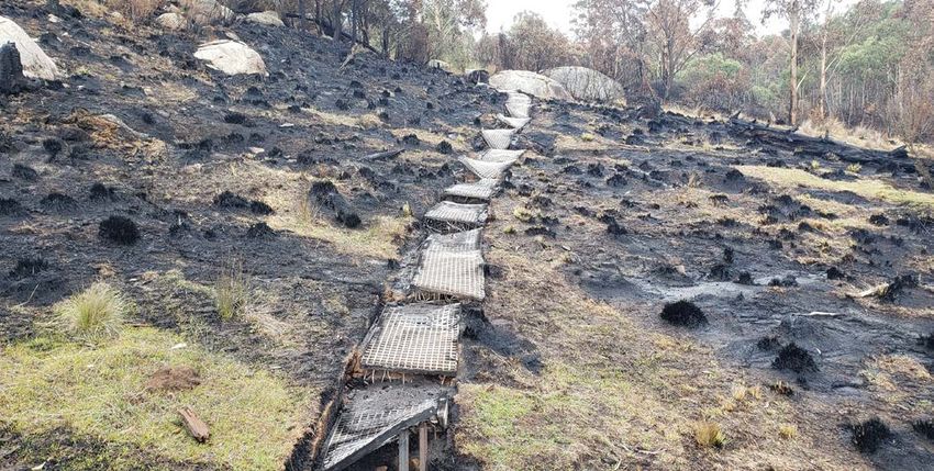
21 Orroral Valley Fire Rapid Risk Assessment Namadgi National ParkDiscipline: Assets Asset name: Visitor Infrastructure Location: Various Risk: High Impact: Injury, damage to infrastructure and environmental contamination Description: Fire impact to walking tracks, camping grounds, picnic areas and car parks Approximately 84 km of walking track and 19 recognised visitor nodes (camping grounds, picnic areas, car parks) are located within the burnt area. The major visitor node for access to the Gudgenby area at Yankee Hat car park is known to have sustained significant fire damage. Likewise, the Booroomba Rocks car park is in an area of very high intensity burn and is assumed to be significantly impacted. All three designated campgrounds in NNP are within the burn area, however none has sustained more than minor damage. The area includes the majority of the specifically constructed walking tracks in NNP and significant damage is either confirmed or expected from either fire impact or suppression works. Initial treatment recommendations > Keep areas closed to public until safety works have been completed > Maintain barriers, signage and regular compliance patrols > Staff to assess all trail infrastructure to accurately record asset damage and needs > Remove all damaged dangerous items > Rebuild assets to current standards > Consider using non-flammable materials wherever possible > Prioritise sites that require less work to enable public access as soon as possible > Ongoing monitoring and maintenance of additional hazards will be required Map: See Map 3 Impacted Assets Orroral Valley Fire See page 23. Photo Damaged boardwalk Brandy Flat Walk Deklyn Townsend Rapid Risk Assessment Team 22
MAP 3: IMPACTED ASSETS ORRORAL VALLEY FIRE

23   Orroral Valley Fire Rapid Risk Assessment Namadgi National Park
HERITAGE

DESCRIPTION
NNP contains a rich cultural landscape, spanning Aboriginal, historic and built heritage. The Aboriginal history of the
region dates back over 25,000 years, and Traditional Custodians maintain a deep connection to the Park, having an
ancestral and ongoing legacy to ‘Care for Country’. Aboriginal cultural values are embedded in tangible places and objects
found throughout the Park, such as ceremonial sites, rock art sites, cultural trees, grinding grooves and artefact scatters.
Evidence of 19th and 20th century European settlement and use is also found throughout the Park, and includes pastoral
properties, stockman’s huts, original survey markers and space heritage sites.

METHODS
The following was undertaken to inform this rapid assessment:
> Review of the known heritage values of the Park, from the heritage databases maintained by ACT Heritage and the
  ACT PCS
> Consultation with Representative Aboriginal Organisations (RAOs) on Aboriginal cultural values and recovery priorities
> Review of information provided by the ESA and PCS on fire preparation and response actions, and on the known
  heritage effects of the fire
> Preliminary analysis of fire intensity, earthworks and post fire erosion at heritage places
> Aerial inspection of several heritage areas, to assess fire effect and intensity

ASSUMPTIONS AND GAPS
Limitations of this rapid assessment include:
> The Park has not been subject to extensive heritage assessment and is likely to contain many unrecorded heritage
  places and objects
> The heritage data set used for this review contains duplicate entries, and due to time constraints, was not subject to
  detailed validation or verification
> No on-ground site inspections or condition assessments were undertaken for this assessment
> RAO availability was limited during the rapid assessment, however, both Buru Ngunawal Aboriginal Corporation and
  King Brown Tribal Group were able to participate in the process

DISCUSSION
All Aboriginal heritage assessment and management actions are to be undertaken in collaboration with Traditional
Custodians; with Representative Aboriginal Organisations (RAOs) to provide guidance on cultural values, cultural protocols
and appropriate outcomes for all proposed actions.
Heritage Act 2004 approvals will be required for some actions recommended in this report, and
ACT Heritage Council advice should be sought on all proposed conservation and recovery actions.
The fire impact has increased ground surface visibility creating a short-term opportunity to undertake highly effective
heritage surveys and assessments throughout. This opportunistic work would improve our understanding of heritage
values and Park management. On this basis, it is recommended that the land manager seek additional funding to
commission cultural landscape surveys and assessments within the next three months, to be undertaken by RAOs and
qualified archaeologists.

Rapid Risk Assessment Team                                                                                                 24
You can also read