Hobart Fire Management Area Fire Protection Plan 2018 - State Fire ...
←
→
Page content transcription
If your browser does not render page correctly, please read the page content below
Hobart Fire Management Area
                       Fire Protection Plan
                                   2018

Hobart Fire Protection Plan 2018              1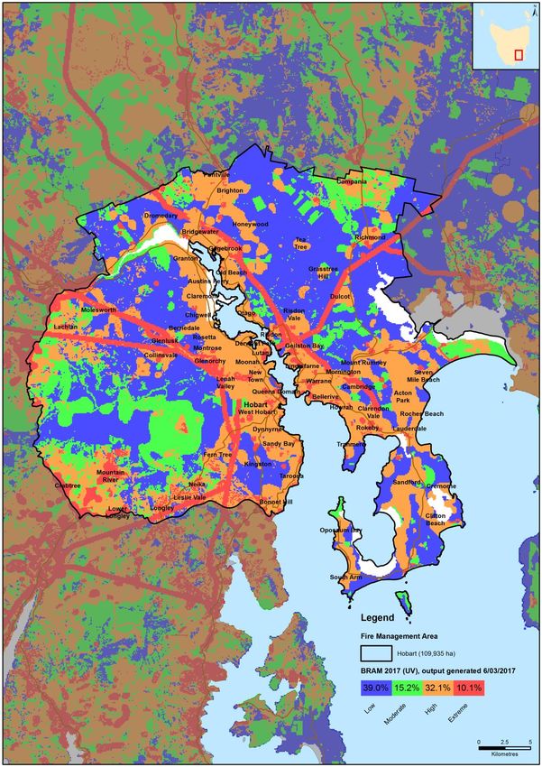
Document Control

Document History

 Version                Date            Authors           Section

 1.0                    16/9/14         AVK, MP, SB       Draft
 1.0b                   23/9/14         SB,AVK            2nd draft
 1.0c                   5/12/14         SB, MP            3rd draft, with picture
 1.0d                   15/12/14        AvK, SB           Draft for circulation
 1.1                    30/12/14        AvK, SB           Finalised.
 1.1b                   13/01/15        SB                FRU Mgr comments
                                                          added
 2.0                    26/11/15        BSP               Draft
 2.1                    29/11/15        AvK BSP           2nd Draft
 2.1                    29/11/15        AvK BSP           2nd Draft
 2.3                    01/12/2016      HFMAC             3rd Draft
 2.4                    9/12/2016       AvK, BSP          FINAL
 3.0                    5/12/2017       BSP               Draft
 3.1                    21/12/2017      HFMAC             FINAL

Document Endorsements

 Agency                  Name & Title     Signature           Date

Document Endorsement
Endorsed by Hobart FMAC Chairman Axel von Krusenstierna

Accepted by State Fire Management Council

SFMC Chair – Ian Sauer
Date:

Hobart Fire Protection Plan 2018                                                    2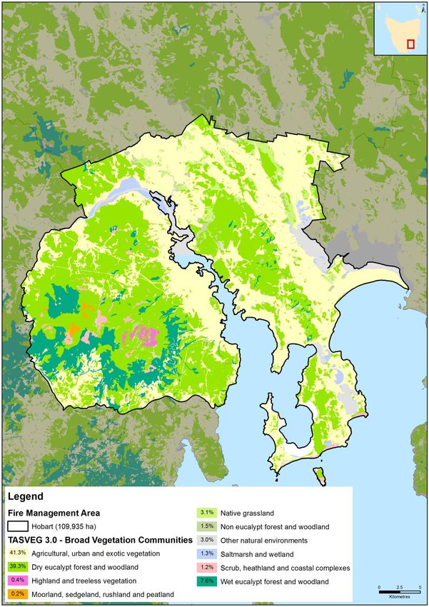
Table of Contents
Glossary ................................................................................................................................................... 5
Acronyms ................................................................................................................................................ 6
Chapter 1 Introduction ........................................................................................................................... 7
   1.1         Background ............................................................................................................................. 7
   1.2         Aim and Objectives ................................................................................................................. 7
   1.3         Implementation Strategy ........................................................................................................ 8
   1.4         Policy, Standards and Legislation ............................................................................................ 9
       1.4.1 Standards ............................................................................................................................... 9
       1.4.2 Legislation .............................................................................................................................. 9
Chapter 2 Establishing the Context....................................................................................................... 10
   2.1         Description of the Hobart Fire Management Area ............................................................... 10
       2.1.1           Location Boundaries and Land Tenure ......................................................................... 10
       2.1.2           Climate and Bushfire Season ........................................................................................ 15
       2.1.3           Vegetation ..................................................................................................................... 16
       2.1.4           Population and Demographics ...................................................................................... 18
Chapter 3 Bushfire History .................................................................................................................... 19
   3.1         Black Tuesday Bushfires (7 February 1967) .......................................................................... 19
   3.2         Bushfire Frequency ............................................................................................................... 19
   3.4         Fire Ignition Cause................................................................................................................. 19
   3.5         Existing Bushfire Management Plans.................................................................................... 22
Chapter 4 Analysing and Evaluating Bushfire Risk ................................................................................ 23
   4.1         Analysing Bushfire Risk ......................................................................................................... 23
   4.2         Likelihood and Consequence ................................................................................................ 23
   4.3         Overall Risk............................................................................................................................ 23
   4.4         Risk Analysis for the Hobart Fire Management Area ............................................................ 24
Chapter 5 Bushfire Risk Treatment ....................................................................................................... 28
   5.1         General Risk Reduction Methods.......................................................................................... 28
   5.2         Treatment Selection and Priorities ....................................................................................... 29
   5.3         Treatment Completed during 2016 ...................................................................................... 29
   5.4         Community Assessment........................................................................................................ 31
   5.5         Strategic Fire Trails................................................................................................................ 33
   5.6         Strategic Fuel Breaks ............................................................................................................. 33

Hobart Fire Protection Plan 2018                                                                                                                            3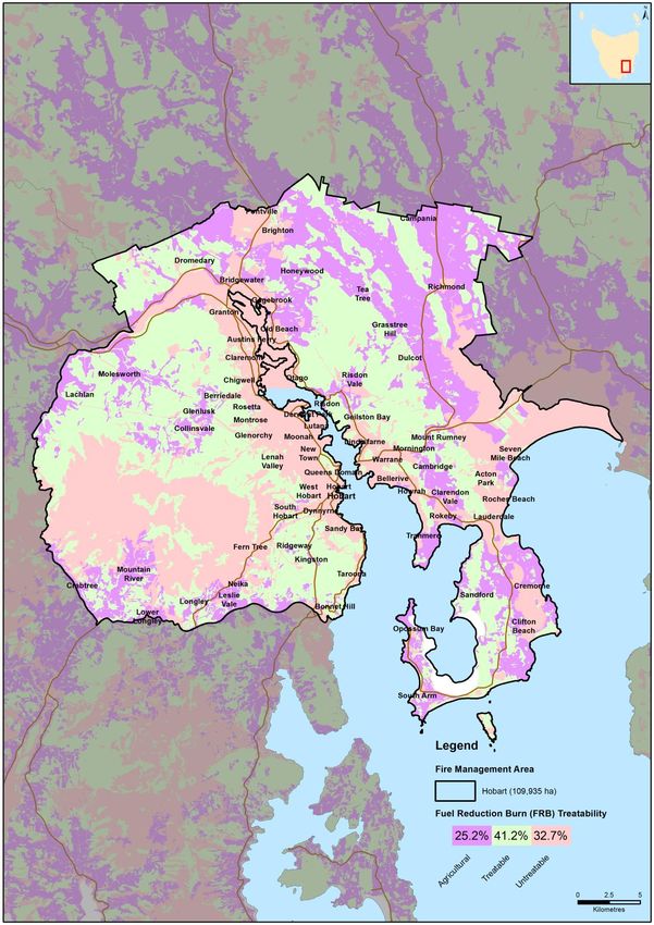
5.7         Annual Works Programs ....................................................................................................... 36
   5.8         Fire Trail Works ........................................................................ Error! Bookmark not defined.
   5.9         TFS Community Fire Safety Programs ................................................................................... 41
   5.10        Implementation .................................................................................................................... 42
   5.11        Community Engagement and Education .............................................................................. 43
Chapter 6 Monitoring and Review ........................................................................................................ 44
   6.1         Review ................................................................................................................................... 44
   6.2         Monitoring and Reporting .................................................................................................... 44
References ............................................................................................................................................ 44
Appendices............................................................................................................................................ 45
   Appendix 1 - Bushfire Risk Reduction Strategy for Hobart FMAC .................................................... 46
   Appendix 2 - Community Specific and General Bushfire Management Plans Already in Place ....... 60
   Appendix 3 – Existing and Proposed Strategic Fire Trails ................................................................. 67
   Appendix 4 – Existing and Proposed Management and Protective Fuel Breaks .............................. 73
   Appendix 5 - The Bushfire Risk Assessment Model (BRAM) ............................................................. 75
   Appendix 6 - NERAG Risk Assessment Approach .............................................................................. 83
   Appendix 7 - National Construction Code Building Classes .............................................................. 88
   Appendix 8 – Treatment Schedule - Annual Works Program .......................................................... 89

Hobart Fire Protection Plan 2018                                                                                                                          4
Glossary
    Asset                       A term used to describe anything valued by the community that may be
                                adversely impacted by bushfire. This may include residential houses,
                                infrastructure, agriculture, industry, environmental and heritage sites.
    Bushfire                    Unplanned vegetation fire. A generic term which includes grass fires,
                                forest fires and scrub fires both with and without a suppression
                                objective.1
    Bushfire hazard             The potential or expected behaviour of a bushfire burning under a
                                particular set of conditions, i.e. the type, arrangement and quantity of
                                fuel, the fuel moisture content, wind speed, topography, relative
                                humidity, temperature and atmospheric stability.
    Bushfire risk               A systematic process to coordinate, direct and control activities relating
    management                  to bushfire risk; with the aim of limiting the adverse effects of bushfire
                                on the community.
    Consequence                 The outcome or impact of a bushfire event.
    Fuel Break                  A natural or man-made change in fuel characteristics which affects fire
                                behaviour so that fires burning into them can be more readily controlled.
                                In the urban-rural interface, a fuel break is an area or strip of land where
                                bushfire fuel continuity has been substantially altered through the
                                strategic removal or modification of vegetation.
    Human                       SFMC has developed a spatial dataset used to define the extent and
    Settlement Area             name of Human Settlement Areas (HSA) in Tasmania. The term Human
                                Settlement Area is used instead of Community for the purposes of
                                clarity. HSAs are defined as where people live or work.
    Likelihood                  The chance of something occurring.
    Risk                        The effect of uncertainty on objectives.2 (Note: Risk is often expressed
                                in terms of a combination of the consequences of an event and the
                                associated likelihood of occurrence.)
    Risk acceptance             The informed decision to accept a risk, based on the knowledge gained
                                during the risk assessment process.
    Risk analysis               The application of consequence and likelihood to an event in order to
                                determine the level of risk.
    Risk assessment             The systematic process of identifying, analysing and evaluating risk.
    Risk criteria               Standards (or statements) by which the results of risk assessments can
                                be assessed. They relate quantitative risk estimates to qualitative value
                                judgements about the significance of the risks. They are inexact and
                                should be seen as guidelines rather than rules.3
    Risk evaluation             The process of comparing the outcomes of risk analysis to the risk
                                criteria in order to determine whether a risk is acceptable or tolerable.
    Risk                        The process of recognising, identifying and describing risks.
    identification
    Risk treatment              A process to select and implement appropriate measures undertaken
                                to modify risk.

1 Australasian Fire and Emergency Service Authorities Council 2012, AFAC Bushfire Glossary, AFAC Limited, East Melbourne, Australia
2 Standards Australia 2009, Risk management – Principles and guidelines, AS/NZS 31000:2009, Standards Australia, Sydney, Australia
3 Emergency Management Australia 1998, Australian Emergency Manuals Series – Manual 3 Australian Management Glossary, Emergency

Management Australia, Dickson, Australia

Hobart Fire Protection Plan 2018                                                                                                  5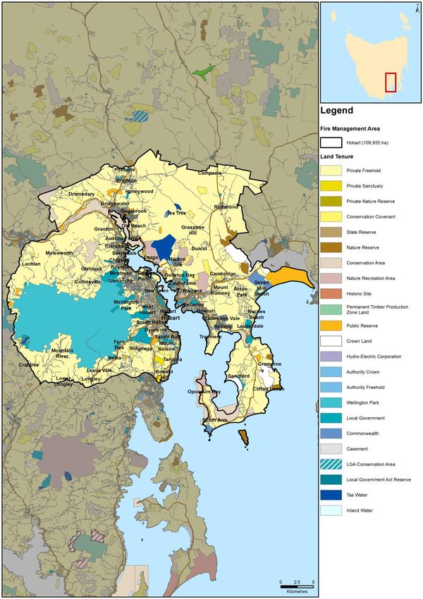
Acronyms
 BC                   Brighton Council

 BPP                  Bushfire Planning and Policy Unit

 CCC                  Clarence City Council

 DOD                  Department of Defence

 DVC                  Derwent Valley Council

 FFDI                 Forest Fire Danger Index

 FDR                  Fire Danger Rating

 FIAT                 Forest Industry Association Tasmania

 FMA                  Fire Management Area

 FMAC                 Fire Management Area Committee

 FPP                  Fire Protection Plan

 FRU                  Fuel Reduction Unit

 GFDI                 Grassland Fire Danger Index

 GCC                  Glenorchy City Council

 HCC                  Hobart City Council

 HFMA                 Hobart Fire Management Area

 HSA                  Human Settlement Area

 KC                   Kingborough Council

 PWS                  Parks and Wildlife Service

 REMC                 Regional Emergency Management Council

 SEMC                 State Emergency Management Committee

 SFMC                 State Fire Management Council

 STT                  Sustainable Timber Tasmania

 TFGA                 Tasmania Farmers and Graziers Association

 TFS                  Tasmania Fire Service

 WPMT                 Wellington Park Management Trust

Hobart Fire Protection Plan 2018                                  6
Chapter 1 Introduction
This fire protection plan for the Hobart Fire Management Area was prepared by the Hobart
Fire Management Area Committee (HFMAC) and State Fire Management Council (SFMC)
executive to cover 2018. It updates and expands on the previous fire protection plan
which covered 2017.
This plan takes a risk management approach and includes a range of measures that would
reduce the bushfire risk within the Hobart Fire Management Area. It should be noted that
it will not be possible to prevent bushfires occurring within the Hobart Fire Management
Area however implementation of this plan should reduce bushfire risk.
The plan is based on risk modelling provided through the SFMC and the knowledge and
expertise of the committee members. It is intended that this and future versions of this
plan will become more comprehensive as further field investigations and detailed local-
scale risk assessments are undertaken and more information is gathered from landowners
and managers.
This version of the plan includes information on strategic emergency vehicle access routes
(fire trails) and fuel breaks. The aim is to identify existing strategic access routes, note
their current condition and identify where new vehicle access is required for fire
management. Similarly, information on existing fuel breaks on public land has been
gathered and the need for additional breaks identified, particularly to protect high value
assets.
1.1 Background
Under Section 20 of the Fire Service Act 1979, fire management area committees are
required to submit to SFMC, on an annual basis, a fire protection plan for its fire
management area.
It is a requirement of the fire protection plan that it is consistent with the State Fire
Protection Plan and the State Vegetation Fire Management Policy. The State Vegetation
Fire Management Policy is currently being reviewed.
1.2 Aim and Objectives
The aim of this FPP is to document a coordinated and efficient approach towards the
identification and treatment of bushfire-related risk within the Hobart FMA.
The objective of this FPP is to effectively manage bushfire related risk within the Hobart
FMA in order to protect people, assets and other things valuable to the community.
Specifically, the objectives of this plan are to:
Guide and coordinate a tenure blind bushfire risk management program;
Document the process used to identify, analyse and evaluate risk, determine
priorities and develop a plan to systematically treat risk;
Facilitate the effective use of the financial and physical resources available for
bushfire risk management activities;
Integrate bushfire risk management into the business processes of Local
Government, land managers and other agencies;
Ensure integration between stakeholders;
Clearly and concisely communicate risk in a format that is meaningful to
stakeholders and the community; and
Hobart Fire Protection Plan 2018 7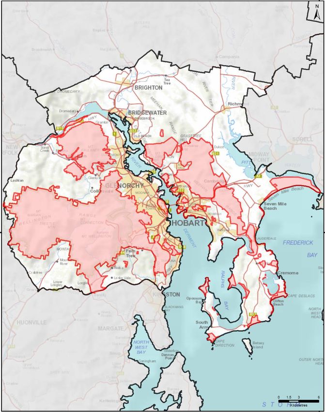
Monitor and review the implementation of the Plan, to ensure enhancements are
made on an on-going basis.
This plan only deals with reducing the risks to life, property and other assets of value from
bushfires, not other types of fire. In areas that fuel reduction burning can’t be undertaken,
community bushfire-ready education programs such as the TFS Bushfire-Ready
Neighbourhoods program can focus activities to help community mitigate their risk.
1.3 Implementation Strategy
This plan takes a risk management approach and includes a wide range of measures to
reduce the bushfire risk within the Hobart FMA. These fall under the following broad
strategies:
1) Reduce the risk of bushfires starting and spreading through:
a) Reducing the number of ignitions within the Hobart FMA
b) Reducing the risk of bushfires that do start spreading
c) Reducing the rate of spread and intensity of bushfires that can’t be immediately
controlled.
2) Reduce the risk of persons being injured or dying as a result of bushfires.
3) Identify and reduce the bushfire risk to the following assets:
a) Residential and other Class 1 to 9 buildings as defined in the National
Construction Code (for an explanation of these classes see Appendix 7)
b) Critical infrastructure including electricity supply, communications, drinking
water supplies, sewerage, transport infrastructure.
c) Cultural heritage values
d) Natural heritage values including threatened species and plant communities,
biodiversity, geoheritage, scenic values
e) Agricultural land and other assets used for primary production.
An outline of the measures being considered to implement this strategy is in Appendix 1.
Hobart Fire Protection Plan 2018 8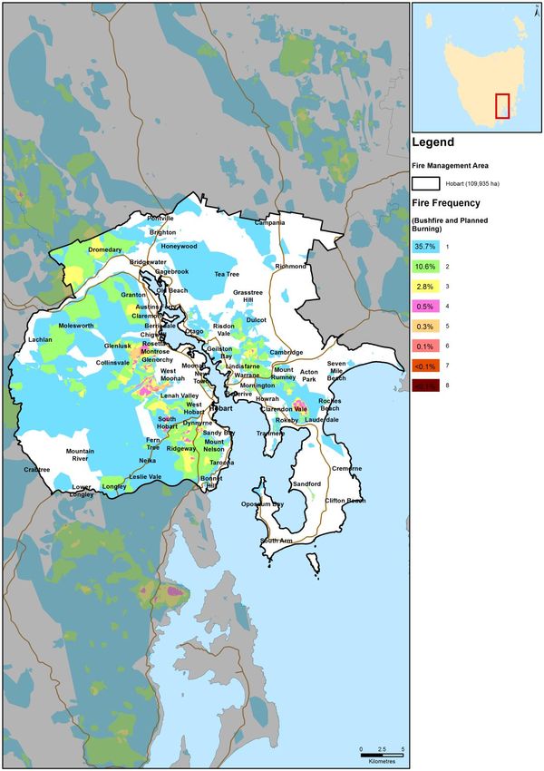
1.4 Policy, Standards and Legislation
The following policy, standards and legislation were considered to be applicable to the
development and implementation of the FPP.
Environment Protection Policy (Air Quality) 2004
Forest Practices Code 2015
Hobart City Council Fire Management Strategy 2014
National Bushfire Management Policy Statement for Forests and Rangelands
2012
Planning Directive 5.1 – Bushfire-Prone Areas Code
State Fire Protection Plan
State Policy on Water Quality Management 1997
State Strategic Fuel Management Plan
State Vegetation Fire Management Policy
Tasmanian Air Quality Strategy 2006
Tasmanian Electricity Code
Tasmanian Emergency Management Plan
Wellington Park Management Plan 2013
PWS Southern Region Fire Management Strategy 2011
Glenorchy City Council Bushfire Mitigation Policy 2017
1.4.1 Standards
AS/NZS ISO 31000:2009 - Risk Management – Principles and Guidelines
AS 3959 – 2009 – Construction of Buildings in Bushfire Prone Areas
1.4.2 Legislation
Aboriginal Relics Act 1975 (soon to be replaced)
Building Act 2000
Crown Lands Act 1976
Emergency Management Act 2006
Environment Protection and Biodiversity Conservation Act 1999 (Federal)
Environmental Management and Pollution Control Act 1994
Fire Service Act 1979
Forest Practices Act 1985, and Forest Practices Regulations 2007
Forestry Act 1920
Historic Cultural Heritage Act 1995
Local Government Act 1993
National Parks and Reserve Management Act 2002
Nature Conservation Act 2002
Threatened Species Protection Act 1995
Weed Management Act 1999
Wellington Park Act 1993
Hobart Fire Protection Plan 2018 9
Chapter 2 Establishing the Context
2.1 Description of the Hobart Fire Management Area
2.1.1 Location Boundaries and Land Tenure
The Hobart Fire Management Area (HFMA) encompasses an area of approximately
110,000 ha. It covers the greater Hobart area and surrounding suburbs. The plan area
also covers satellite suburbs and outlying communities including Lauderdale, Seven Mile
Beach, Richmond, Brighton, Fern Tree, Molesworth, Lachlan and Mountain River. It
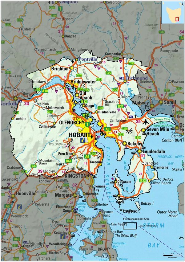
includes the local government areas of Hobart, Glenorchy, Clarence, Brighton and parts
of Kingborough and Derwent Valley (see Figure 2.1).
The HFMA has a number of distinctive geographical features; firstly the River Derwent
which roughly bisects the FMA: the Wellington Range which runs westward from the
suburbs of Hobart and the Meehan Range which runs roughly north to south on the
eastern side of the Derwent River. Altitudes within the HFMA range from sea level to
1271m above sea level at the pinnacle of kunanyi / Mount Wellington.
Land tenure is predominantly private with Wellington Park making up the largest area of
publicly owned land (see Figure 2.2).
Land Manager/Agency % of Land Managed within the FMA
Private Property 65
Wellington Park Management Trust 14
DPIPWE 8
Local Government 4
Other 9
Table 2.1 - Overview of major land management agencies within the Hobart FMA
This fire prevention plan only covers areas identified as Type 1 and Type 2 interface areas
within the Hobart FMA (see Figure 2.3).
The urban-rural interface is defined as: the line, area, or zone where structures and other
human development adjoin or overlap with undeveloped bushland. This is where the
degree of risk to life and property is most pronounced, and historically where the greatest
losses have occurred.
The Tasmania Fire Service classifies the urban-rural interface into two distinct classes
based on the pattern of development within this zone:
Type 1 (Classic) Interfaces are areas where there is a clear distinction between built and
natural environments and there are multiple dwellings in close proximity.
Hobart Fire Protection Plan 2018 10Type 2 (Mixed) Interfaces are areas where structures are scattered within bushland areas so that the built and natural environments are blended. Dwellings are spaced further apart often with intervening bushland. Hobart Fire Protection Plan 2018 11
Figure 2.1: Extent of the HFMA.

Hobart Fire Protection Plan 2018   12
Figure 2.2: Broad land tenure across the HFMA

Hobart Fire Protection Plan 2018                13
Figure 2.3 showing Type 1 and Type 2 interface areas in the HFMA

Hobart Fire Protection Plan 2018                                   14
2.1.2 Climate and Bushfire Season High risk fire weather can be expected from time to time in southern Tasmania when dry winters and springs are followed by summers where fuels are very dry. The strong north- westerly winds that often precede cold fronts in summer can contain dry air from the interior of the Australian mainland. These winds pick up some surface moisture crossing Bass Strait, but as the air stream descends from the Central Highlands dry air at a higher altitude descends to the surface resulting in extremely low humidity. This combination of strong winds and low humidity creates the ideal meteorological conditions for major bushfires in south-east Tasmania and particularly the Hobart Fire Management Area. Fires that start under these conditions can be expected to move quickly downwind, and then move more or less at right angles on a broad front when the subsequent south- westerly wind change arrives. These fires can reach a very high intensity in a short time, even in areas with relatively low fuel loads, and are very difficult to control until the weather conditions abate. These were the conditions that produced the 1967, 1998, 2006 and 2013 bushfires around Hobart. Unlike the rest of Tasmania, the Derwent Valley and south east of Tasmania regularly experience Extreme to Catastrophic fire danger ratings. The Hobart FMA is also one of the driest parts of Tasmania (see Figure 2.4) Relevant BOM weather stations located within the HFMA: Grove Hobart Hobart Airport Kunanyi/Mt Wellington Hobart Fire Protection Plan 2018 15
Figure 2.4: Mean annual rainfall across Tasmanian Fire Management Areas

2.1.3 Vegetation
The vegetation within the Hobart FMA has been classified into broad fuel types with similar
bushfire hazard characteristics shown in figure 2.5.

Almost half the HFMA is covered by cleared land, either for urban development or for various
types of agriculture. The remaining native vegetation is predominantly dry Eucalypt forest and
woodland. Wet forest is mainly confined to the eastern and southern slopes of the Wellington
Range.

Hobart Fire Protection Plan 2018                                                           16
Figure 2.5 Vegetation types across the HFMA (based on grouped TASVEG
vegetation mapping)

Hobart Fire Protection Plan 2018                                  17
2.1.4 Population and Demographics
Settlement is concentrated along the shores of the Derwent River Estuary and Fredrick
Henry Bay as shown on Figure 2.6. The only sizable settlements away from the coast are
Brighton, Richmond and Risdon Vale. Settlement in the HFMA is dominated by two urban
areas on either side of the Derwent River, as well as these large settlement areas there
are a number of smaller towns, villages and settlement areas separated from the main
urban areas by bushland (for example Risdon Vale, Ridgeway, Molesworth).
The HFMA also contains large areas of rural residential development (Type 2 Interface),
mainly ~2 ha lots where homes are scattered and there is no distinct urban/bushland
boundary (for example Acton, Sandford, Leslie Vale).
Figure 2.6 Map of population density in the HFMA
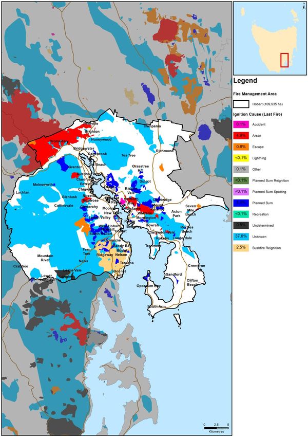
Hobart Fire Protection Plan 2018 18Chapter 3 Bushfire History 3.1 Black Tuesday Bushfires (7 February 1967) On 7 February 1967. A total of 110 separate fire fronts burnt through some 2,640 square kilometres of land in Southern Tasmania within the space of five hours. A large part of the Hobart FMA was affected by the Black Tuesday bushfires. In total, the fires claimed 62 lives in a single day. Property loss was also extensive with 1293 homes and over 1700 other buildings destroyed. The fires destroyed 80 bridges, 4800 sections of power lines, 1500 motor vehicles and over 100 other structures. It was estimated that at least 62,000 farm animals were killed. The total damage amounted to $40,000,000 in 1967 Australian dollar values. 3.2 Bushfire Frequency Fire frequency is defined as the total number of fires that occurred in the same area. Figure 2.7 shows areas known to have been affected by fire (including prescribed burns) in the HFMA since the 1967 bushfires based on records provided by the Tasmania Fire Service, local government, Wellington Park Management Trust, Parks and Wildlife Service and other sources. However, the records are incomplete and do not include burning carried out by private landowners. The figure therefore substantially underestimates the area burnt and frequency of burning. 3.4 Fire Ignition Cause The true causes of fire, either through ignition by lightning or caused by human actions have not been well documented prior to 1990. Table 2.2 give a summary of ignition causes based on available data since 1967. Ignition source Percentage of ignitions (%) Unknown 44 Arson 29 Undetermined 9 Recreation 8 Escape 3 Other 7 Table 2.2 Summary of ignition sources Figure 2.8 shows the area burnt by fires started by different causes since 1967. The number of bushfires in the HFMA started by non-human related causes is very low. This indicates that a significant reduction in the risk of fires starting can be achieved through public education and vigilance. Hobart Fire Protection Plan 2018 19
igure 2.7 Fire Frequency

Hobart Fire Protection Plan 2018   20
Figure 2.8 Analysis of Fire Causes

Hobart Fire Protection Plan 2018     21
3.5    Existing Bushfire Management Plans
Over the last 15 years a number of land owners and management agencies within the
HFMA have prepared fire management plans and strategies for the land under their
control. More recently the TFS Bushfire Planning and Policy Unit has prepared tenure
blind Community Bushfire Mitigation Plans for high risk areas that did not have existing
plans. Existing plans are listed in Appendix 2. Some of these strategies and plans are
being actively implemented, some have been partially implemented and others have not
yet been implemented, sometimes due to a lack of resources or there being no obvious
agency or person to take responsibility.

Figure 2.7 Areas of the HFMA currently under some form of fire risk management plan

Hobart Fire Protection Plan 2018                                                     22
Chapter 4 Analysing and Evaluating Bushfire Risk
4.1    Analysing Bushfire Risk
Following the Australian Standard of risk assessment (ISO 3100) bushfire risk has been
considered spatially, assessing a combination of likelihood and consequence (PWS
2011). The Bushfire Risk Assessment Model (BRAM), data run of 24 March 2016 was
used to give a preliminary indication of landscape level risk for this plan. For details on the
operation of the model, see Appendix 5.

To determine overall risk the NERAG (National Emergency Risk Assessment Guidelines
August 2009) document (see Appendix 6) was used. The level of risk is determined by
combining consequences and likelihood.

It must be noted that the BRAM and therefore the consequences, likelihood and risk
outputs are based on available spatial data. The analysis has been undertaken on a
statewide basis, and maps are presented as complete for Tasmania. There are however
gaps in the data inside and outside areas of public land. This includes fire history
information, particularly on private land, which contributes to ignition potential information
(likelihood), and many of the agricultural values have not been well captured
(consequence). Notwithstanding these limitations, and where the inputs are accurate, the
model can provide an objective spatial analysis of bushfire risk in a landscape.

4.2    Likelihood and Consequence
Likelihood is defined as a qualitative method to assess the likelihood rating to the
consequences occurring. The likelihood of an event was generated by the average
combinations of the output generated from the following spatial information: ignition
potential, suppression capabilities and fire behaviour potential, followed by assigning
these output values to categories in a likelihood matrix. This is taken to mean the likelihood
of a fire occurring in a specific area which surpasses the ability of the fire agencies to
contain within the first 24 hours.

Consequences are defined as a qualitative rating of damage from fire to values. The
consequences were taken directly from the output generated through the Values at Risk
spatial layer output.

4.3    Overall Risk
A representation of risk (see Appendix 6) is developed when the factors of likelihood and
consequence are combined. The generated output map of risk shows qualitative areas of
risk, not areas of perceived risk.

The model assists in objectively defining areas where genuine risk is present. In-depth
analysis will indicate what factor is driving the risk for a given area, and thus guide the
determination of appropriate risk management techniques.

Hobart Fire Protection Plan 2018                                                            23
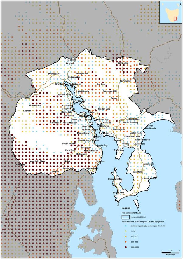
4.4    Risk Analysis for the Hobart Fire Management Area

The BRAM bushfire risk model, discussed above, was used to examine risk across the
HFMA. The preliminary results of this risk analysis are shown in Figure 3.1. Some
members of the Hobart FMAC noted anomalies in the bushfire risk output shown in Figure
3.1 and these will be investigated and, if necessary, corrected during further development
of the plan.
The Phoenix Rapidfire software package (a bushfire simulator developed by Kevin
Tolhurst and Derek Chong at the University of Melbourne) was used to model the risk of
fires impacting on communities present in the HFMA. This modelling was done as part of
the state wide strategic fuel management assessment. The process involved modelling
potential ignition points, incorporating severe fire weather components and examining fire
behaviour based on current fuel loads to identify the potential impact on human settlement
areas. Figure 3.2 shows a preliminary analysis of potential ignition points that may impact
on communities in the HFMA with areas (ha) of impact under current fuel loads. For each
ignition point the model was run for a period of 10 hours, and assumes that there is no
intervention to control the bushfire.
An understanding of where the fires that are likely to impact on communities originate is
crucial. It must be understood that such analysis has many limitations but does provide
an indication of which communities may be at risk as well as identifying areas where
strategic burning will assist in changing fire behaviour.

Strategic fuel reduction burning is one treatment to reduce risk to communities throughout
the HFMA. However, not all vegetation and land use types are treatable through burning.
Figure 3.3 shows treatability of fuels through broad –area fuel reduction burning in the
HFMA. In summary, 41% of fuels are treatable by burning, while 54% are untreatable, the
remaining 5% being water bodies. Note that figure 3.3 is a preliminary assessment that
requires refinement, for example, urban areas have been shown as “untreatable fuel”.
These areas will be removed from the final map when an assessment of bushfire prone
areas within the Hobart FMA is completed.

The distinction between treatable and untreatable fuel was determined by considering the
TASVEG flammability attributes and gives only a general indication of suitability. At an
operational level the distinction between treatable and untreatable fuels will need to be
determined in the field. It should be noted that fuels that are not considered treatable by
large burns may be treatable by smaller planned burns and other methods of fuel
reduction, (such as slashing or mulching, and mechanical thinning and pile burning)
particularly close to settlements and other assets at risk. These areas will be identified
through site inspections and considered a high priority for the establishment of protective
fuel breaks where they adjoin residential areas.

The untreatable portion (54% of the area) includes agricultural land. This is primarily
because whilst agricultural land will burn, it is not generally targeted for fuel reduction
burning as the risk can be seasonally variable and managed by other means. It is likely
that the dryland agricultural land through the region does contain areas of grasslands that
are treatable through burning, however current TASVEG mapping does not break the
agricultural land mapping unit into different categories. Land use mapping may be
incorporated into future risk analyses as data become available allowing refinement of this
category.

Hobart Fire Protection Plan 2018                                                        24
Figure 3.1: Preliminary BRAM output for the Hobart FMAC

Hobart Fire Protection Plan 2018                          25
Figure 3.2: Preliminary analysis of potential ignition points that may impact on
communities in the HFMA with areas (ha) of impact under current fuel loads, using the
Phoenix Rapidfire simulation model

Hobart Fire Protection Plan 2018                                                  26
Figure 3.3: Preliminary analysis of treatability of fuels through fuel reduction burning
in the HFMA

Hobart Fire Protection Plan 2018                                                       27
Chapter 5 Bushfire Risk Treatment
5.1 General Risk Reduction Methods
The following controls are currently in place across the Hobart FMA to assist in the
strategic management of bushfire related risk:
Legislative controls – including abatements, fire restrictions etc.;
Public education campaigns and the use of TFS and SFMC state-wide programs
tailored to suit local needs; (e.g. Private land burning; Community Protection
Planning; Bushfire Ready Neighbourhoods);
State-wide arson prevention programs developed in conjunction with TAS Police
and TFS;
Setting of appropriate land subdivision and building standards in line with the
Bushfire Prone Areas Code and building regulations;
Performance monitoring and reporting of FPP outcomes to the relevant Emergency
Management Council and State Fire Management Council as required by the
Tasmanian Emergency Management Plan and the Fire Service Act;
Bushfire management strategies developed and implemented by Hobart City
Council, Clarence City Council, Wellington Park Management Trust, Department
of Defence, Glenorchy City Council and the University of Tasmania.
The means of implementing the bushfire risk reduction strategies in section 1.3 are
summarised as:
Increasing the resistance of built and other assets to bushfire attack;
Fuel management – Treatments include the reduction / modification of bushfire
fuels through manual, chemical and prescribed burning methods;
Ignition management - Treatments aim to reduce the occurrence of human induced
ignitions in the landscape and reduce the risk of fires spreading out of control;
Preparedness – Treatments focus on providing suitable access and water supply
arrangements that will assist with firefighting operations;
Planning – Treatments relate to the development of plans that will improve the
ability of firefighters and the community to respond to bushfire; and
Community Engagement and education – Treatments seek to build relationships,
raise awareness and change behaviours relating to the management of bushfire
related risks within the community.
These have been grouped into 7 broad treatment goals:
1. Reduce the Incidence and severity of bushfires
2. Reduce the bushfire risk to persons
3. Reduce the Bushfire risk to build assets
4. Reduce the bushfire risk to critical infrastructure
5. Reduce the bushfire risk to cultural heritage values
6. Reduce the bushfire risk to natural heritage values
7. Reduce the bushfire risk to primary production.
Hobart Fire Protection Plan 2018 28The 7 treatment goals provide a comprehensive framework for overall bushfire risk reduction.
The current status of these 7 goals and the actions recommended to achieve them is
summarised in Appendix 1.
Within the HFMA, the Parks and Wildlife Service, Tasmania Fire Service and Norske Skög
have the capability to plan and carry out planned burns. Clarence and Hobart Councils
also have this capability and both have active burning programs. Glenorchy City Council
is developing a five year burn program.
5.2 Treatment Selection and Priorities
The determination of priorities and potential treatment methods is currently based largely on
the results produced by BRAM and Phoenix Rapid fire modelling, augmented with the
knowledge and expertise of the committee members. The plan aims to improve this through
systematic field investigations or fine-scale modelling when resources become available.
5.3 Treatment Completed during 2017
The following areas were hazard reduced during 2017 by the Fuel Reduction Unit of the TFS,
PWS, Hobart and Clarence Council’s or other agencies. The location of the burns is shown
of figure 4.1.
Land Area Date
Location fmu_name
Tenure (ha) Completed
Waverley Flora Park CCC Waverley Flora Park VMU 14 1 Apr-17
Gellibrand Drive CCC Mortimer Bay 13 4 Apr-17
Waverley Flora Park CCC Waverley Flora Park 11 2 May-17
Waverley Flora Park CCC Waverley Flora Park 26 3 May-17
Mount Nelson HCC Lambert Skyline Ls15 6 Oct-17
Queens Domain HCC Queens Domain 5, Queens Domain 7 11 May-17
Lenah Valley North HCC Wellington Park 26, Wellington Park 29 28 Apr-17
Porter Hill 11, Porter Hill 14, Porter Hill
Porter Hill HCC 15 16 Apr-17
Knocklofty HCC Knocklofty, McRobies Gully KR17 B 4 Apr-17
Queens Domain HCC Queens Domain 8 6 May-17
Meehan Range PWS Simmons Hill 95 Jun-17
Risdon PWS Porter Bay 46 Apr-17
Mount Direction PWS Direction Drive 74 Mar-17
Sugarloaf Hill, Risdon
Vale Private Hyden Rd 5 Mar-17
UTAS UTAS Olinda Grove 10 Apr-17
The Lea Private Colonels Creek 62 May-17
South Arm Private Mt Mather 25 Oct-17
Huon Rd, Fern Tree Private Huon Road 11 Apr-17
Jordan River, Gagebrook Private Sattler Street 31 Mar-17
Littlejohn Ck, Glenorchy WPMT Wellington Park 1 90 Apr-17
Fisher Drive, Gagebrook Private Fisher Drive 4 Mar-17
South Arm Private Lazenby South Arm 42 May-17
Knocklofty Private Ross Rivulet 4 Apr-17
Hobart Fire Protection Plan 2018 29Figure 4.1 Areas burnt to November 2017 Hobart Fire Protection Plan 2018 30
5.4    Community Assessment
Strategic assessment tools have been used to conduct a preliminary assessment across the
Hobart FMA to identify areas of extensive bushland where relatively high intensity bushfires
could occur and where, due to more rugged terrain, they are likely to be more difficult to
control. These areas are shown on figures 4.2.

Potential burn areas that are relatively well understood to be high-risk

These areas are shown in figure 4.2 as purple circles
       39. The Albion Heights/Bonnet Hill/Firthside areas
       40. Dulcot
       41. The Gellibrand Drive/Dorans Hill Rd Sandford
       42. Goat Hills
       43. Government Hills
       45 Huon Rd/ Turnip Fields
       46. Lachlan area
       47. The Meehan Range from Quoin Ridge to Lauderdale, particularly the Mount
       Rumney/Mount Canopus area
       49. Mount Dromedary
       50. Mount Faulkner/Big Rocky area
       51. The Mount Nelson/Tolmans Hill/The Lea areas
       52. Pottery Rd/Fossil Hills
       53. The Ridgeway and Summerleas Road areas
       54. Rokeby Hills/Acton
       55. The Wellington Range, particularly the eastern slopes of kunanyi / Mount
       Wellington
       56. Leslie Vale/Longley area

Potential burn areas requiring more detailed investigations

Communities within and bordering these areas are likely to be subjected to high intensity fires
at some time in the future. Further analysis will be required to determine the appropriate
bushfire risk reduction measures for individual communities.
38. Albion Heights West
48. Molesworth/Collinsvale/Glenlusk area
44. The Airport and immediate surrounds
A number of communities already have specific plans in place, these are summarised in
Appendix 2.

Hobart Fire Protection Plan 2018                                                            31
Figure 4.2 Priority Areas Hobart Fire Protection Plan 2018 32
5.5    Strategic Fire Trails
Currently identified strategic fire trails within the Hobart FMA and their condition are shown in
Appendix 3.

Strategic fire trails are those that provide important access routes for fire fighting, through or
along the perimeter of bushland areas, and are potential control lines for major fires. These
trails need to be maintained to a standard that allows for all weather vehicle access by fire
fighting vehicles. This will generally be Class 3 in the PWS fire trail classification system. Fire
Trails that are currently substandard should be upgraded to at least Class 5.

5.6    Strategic Fuel Breaks
These are natural or man-made changes in fuel characteristics which affect fire behaviour
so that fires burning into them can be more readily controlled. The Draft Fuel Break
Guidelines (TFS, 2016) states that: “in the urban-rural interface, a fuel break is an area or
strip of land where bushfire fuel continuity has been substantially altered through the
strategic removal or modification of vegetation”. The fuel modification is generally carried
out and the breaks maintained by mechanical and/or manual removal of fuel rather than
burning. Firebreaks are a specific type of fuel break where all vegetation is removed.
Fuel breaks provide access along the urban/bushland perimeter and should, where
possible include a fire trail.

They increase the separation between built assets and the bushfire hazard and may
complement Hazard Management Areas on private property. Fuel breaks facilitate fire
fighting operations such as back burning and direct attack and may provide control lines
for planned burns.

Hobart Fire Protection Plan 2018                                                                33
The Draft Fuel Break Guidelines (TFS, 2016) defines 2 classes of fuel break:

Hobart Fire Protection Plan 2018                                               34
Management Fuel Breaks form part of a broader Asset Protection Zone and need to be
complimented by other fuel management treatments to provide sufficient protection to life
and property during bushfires. Their main performance criteria is that the radiant heat
impacting on a structure on one side of the fuel break during back burning or planned
burning of the vegetation of the other side of the break will be less than 12.5 kilowatts per
square metre (kW/m2).

Protective Fuel Breaks provide protection to life and property on the urban-rural interface
in situations where it is unfeasible or undesirable to implement broader-scale fuel
management works within proximity to the interface. They will be wider than a
Management Fuel Break in the same location. Their main performance criteria is that the
radiant heat impacting on a structure on one side of the fuel break during a bushfire
burning in the vegetation in the other side of the break in conditions up to a Fire Danger
Index (FDI) of 50 (Severe Fire Danger Rating) will be less than 12.5 kilowatts per square
metre (kW/m2).

As the HFMA regularly experiences FDIs greater than 50, there is a strong case for using
a higher FDI to determine what an adequate width is for Protective Fuel Breaks in the
HFMA. In high risk areas it is recommended that an FDI of 100 (Catastrophic Fire Danger
Rating) is used.

Both Hobart and Clarence Councils maintain a network of fuel breaks between their larger
bushland reserves and surrounding urban areas. The University of Tasmania similarly
maintains fuel breaks around its bushland reserve on Mount Nelson.

The strategic fuel breaks in the Hobart FMA are shown in Appendix 4. At present
Appendix 4 only includes fuel breaks on public land.

Hobart Fire Protection Plan 2018                                                          35
5.7    Annual Works Programs
The annual program of works for several of the HFMAC member agencies is tabulated below.
It includes works already planned by land management agencies and additional burns in key
locations. Land managers and fire agencies are responsible for incorporating the works into
their respective annual works programs and planning processes.

PWS and TFS Management Burn Activity Autumn and Spring 2017:

          Agency                               Location                       Approx.
                                                                                Area
 Parks and Wildlife Service    Hobart College, Simmons Hill, Oakleigh       250 ha
                               Ave Taroona, Stringybark Gully, Cape
                               Deslacs and Clifton Beach
 Tasmania Fire Service         Mt Falkner, Wellington Park, Tolmans Hill,
                               Mt Nelson, Knocklofty, Lenah Valley, The     2050 ha
                               Lea, Strickland Avenue, Quoin Ridge

In addition to these larger burns, the following burns are proposed by Clarence and Hobart
City Councils for 2017.

Clarence City Council Management Burn Activity 2017

   1. Waverley Flora Park - proposing 5 Burns with size ranging from 0.5 to 5 ha

   2. Mortimer Bay Coastal Reserve -2 burns from 1 to 3 ha

   3. Roscommon Recreation Reserve I burn of 1 ha

   4. Pilchers Hill Bushland Reserve 1 burn of 49 ha

   5. Gellibrand Drive Road Reserve – Mosaic pattern of approx. 5 strip burns approx .2
      ha

   6. Across 19 Bushland Reserves series of small fuel heap burns

Hobart Fire Protection Plan 2018                                                             36
City of Hobart Hazard Reduction Burns 2018-2019
Total
Reserve MU ID CoH Burn ID Area (CoH) Area (Other) Area Scheduled Season
Bicentennial Park BP002 Lower Enterprise 2.9 2.9 2018 Autumn
Cascade Pottery Road 4 67.2 71.2 2018 Autumn
Knocklofty Reserve KR010 Knocklofty West 57.2 3.2 60.4 2018 Autumn
Mount Nelson BW001 Brinsmead West 1.9 1.9 2018 Autumn
Mount Nelson Hobart College - PWS 4.4 14.4 18.8 2018 Autumn
Queens Domain QD010 Brooker Quarry 9.2 9.2 2018 Autumn
Queens Domain QD006 Grassland 9.1 9.1 2018 Autumn
Ridgeway Park RP013 Chimney Pot Hill - FRU 40 40 2018 Autumn
Ridgeway Park RP001, RP002 Depot South 23.7 23.7 2018 Autumn
Wellington Park WP031 Breakneck (Stage 2) - FRU 57.5 57.5 2018 Autumn
Bicentennial Park BP009 Signal Station North 21.5 21.5 2018 Spring
Bicentennial Park BP003 Rialannah North 5.5 5.5 2018 Spring
Porter Hill PH001 Gardenia East 8.1 8.1 2018 Spring
Ridgeway Park RP015, RP016 Ridgetop South 18.2 18.2 2018 Spring/Autumn
Queens Domain QD004 Cleary's North 16 16 2019 Autumn
Ridgeway Park RP010 Pipeline Track North 35.6 35.6 2019 Autumn
Ridgeway Park RP013 Ridgeway Oval 19.7 19.7 2019 Autumn
Wellington Park WP039 Inglewood 30.1 30.1 2019 Autumn
Knocklofty Reserve KR003 Knocklofty Summit 40.7 40.7 2019 Spring
Knocklofty Reserve KR001 Mount Stuart Lookout 2.4 2.4 2019 Spring
Knocklofty Reserve KR007 Forest Road 13.8 0.5 14.3 2019 Spring
Queens Domain QD011 Quarry South 3.2 3.2 2019 Spring
Queens Domain QD008, QD009 Joggers Loop West 12.6 12.6 2019 Spring
McRobies Gully MG001 McRobies North 20.9 20.9 2019 Spring/Autumn
McRobies Gully MG002 North Tip Face 45.7 45.7 2019 Spring/Autumn
Porter Hill PH003 Riverview 5.9 5.9 2019 Spring/Autumn
Hobart Fire Protection Plan 2018 37City of Hobart Hazard Fire Trail Works 2018-2019 Reserve CoH FT Name Length (CoH) Upgrade New Work Bicentennial Park Nicholas 1.4 Cat 3 Queens Domain QD North 1.6 Cat 3 Ridgeway Vauxhall's 1.1 Cat 3 upgrade Knocklofty Victors 0.7 Cat 3 Waterworks McDermot's 1.7 Cat 3 upgrade Waterworks McDermot's Farm 0.2 New Crossing Wellington Park Lenah Valley 0.7 Cat 3 Upgrade Wellington Park Middle Island FT 1.5 Cat 3 McRobbies Gully Landfill Access 0.5 Cat 3 City of Hobart will also be continuing the extension of the TAsFire Fuel Break Guidelines into the remainder of the Dry Eucalypt zone over 52 sites and the Wet Eucalypt Zones in 24 sites in all totalling 52 Ha. City of Hobart will be repairing and maintaining the 80km of existing fire trails with recurrent maintenace works contract across the reserve system. This is in addition to the new works and upgrades identified in the table. Hobart Fire Protection Plan 2018 38
Glenorchy City Council

               2018 GCC Proposed Planned Burning Program

                                                                   GCC
 Reserve/Location
                                         FMU:                      Land
        :
                         Season:                      Size (ha):   (ha):        Grid Reference:
                                                                                E: 519,982 / N:
Wellington Park                          8 & 11
                      Autumn/Spring                      11         11             5,255,350
                                                                                E: 519,368 / N:
Wellington Park                               1
                      Autumn/Spring                      50         50             5,256,974
                                       6, 7, 8, 10,                             E: 519,091 / N:
Goat Hills
                      Autumn/Spring     11 & 13          70         44             5258,739
                                                                                 E: 518,764 /
Lowes Ridge                                  N/A
                      Autumn/Spring                      64         22            N:5260,073
                                                                                 E: 520,753 /
Oak Hills                                    N/A
                      Autumn/Spring                      15
2018 GCC Proposed General Bushfire Mitigation Works
Reserve/Location: Works:
1) Development Poimena Reserve & Roseneath Park Bushfire
Poimena Reserve Mitigation Plan
2) Establishment/maintenance of hazard managmement areas.
Amy Street 1) Development Amy Street Community Park Bushfire Mitigation
Community Park Plan
2) Establishment/maintenance of hazard managmement areas.
Goat Hills 1) Review of Goat Hills Bushfire Mitigation Plan
1) Development Lowes Ridge (GCC owned Land) Bushfire
Lowes Ridge Mitigation Plan
Fire Trail and Fuel Break Works:
Annual Programs:
HCC annual fire trail inspections and firebreak program
CCC fire trail and firebreak works
PWS works programs
GCC fire break and fire trail works
New Works [to be detailed in future versions of this plan]
Hobart Fire Protection Plan 2018 405.9 TFS Community Fire Safety Programs
Community Education- Bushfire-Ready Neighbourhoods Program and Bushfire Policy and
Planning- Community Protection Planning have the following plans for the Hobart FMA:
TFS Community Bushfire Protection Plans
Bushfire Protection
FMAC Plan Date
Hobart Bonnet Hill November 2012
Hobart Collinsvale Area March 2013
Hobart Dulcot March 2013
Hobart Fern Tree March 2013
Glenorchy/Lenah Valley
Hobart Area October 2014
Hobart Granton/Berridale Area October 2014
Hobart Lachlan Area October 2013
Hobart Molesworth Area March 2013
Hobart Mt Nelson/Tolmans Hill March 2013
Hobart Mount Rumney Area March 2013
Hobart Neika/Leslie Vale March 2013
Hobart Ridgeway March 2013
Hobart Risdon Vale Area October 2015
Hobart South Hobart March 2013
Hobart Summerleas March 2013
Hobart Taroona Area November 2012
Hobart The Lea November 2012
Hobart Sandford September 2017
Hobart Lauderdale 2018
Hobart Fire Protection Plan 2018 41TFS Community Bushfire Response Plans
Bushfire Response
FMAC Plan Date
Hobart Bonnet Hill December 2012
Hobart Collinsvale Area March 2012
Hobart Dulcot March 2012
Hobart Fern Tree February 2012
Glenorchy/Lenah Valley
Hobart Area October 2014
Hobart Granton/Berridale Area August 2014
Hobart Lachlan Area July 2013
Hobart Molesworth Area March 2012
Hobart Mt Nelson/Tolmans Hill March 2012
Hobart Mount Rumney Area March 2012
Hobart Neika/Leslie Vale March 2012
Hobart Ridgeway March 2012
Hobart Risdon Vale April 2016
Hobart South Hobart March 2012
Hobart Summerleas February 2012
Hobart Taroona Area December 2012
Hobart The Lea November 2012
Hobart Margate July 2015
Hobart Sandfly/Longley October 2015
Hobart Sandford September 2017
Hobart Lauderdale 2018
Community Bushfire Mitigation Plans
Bushfire Mitigation
FMAC Plan Date
Hobart Lenah Valley South May 2015
Hobart Mt Nelson/The Lea August 2014
Mt Nelson/The Lea
Hobart Stage 2 January 2016
Hobart Sandfly/Longley August 2016
Hobart Glenorchy South January 2016
Hobart UTAS December 2016
5.10 Implementation
When the bushfire risk reduction measures identified in this plan are implemented there
are a number of issues that need to be considered by the responsible agency including
environmental and social impacts, risk assessments, coordination with other management
activities, setting up any required monitoring. Any planned burns will require burn plans
and consideration of smoke impacts on health and viticulture. Community education has
an important role in preparing the public for bushfire mitigation.
Hobart Fire Protection Plan 2018 425.11 Community Engagement and Education
Bushfire-Ready Neighbourhoods Program - Tasmanian Fire Service
A Community Development Coordinator and regionally based Community
Development Officers (Hobart, Launceston and Burnie) have identified 22
communities/areas state-wide which are being targeted by the Bushfire-ready
neighbourhoods program as part of round 2 (2016 to 2018) of the program. The
program takes a community development (‘grass roots’) approach and recognises
that there isn’t a one size fits all approach to bushfire preparedness, highlighting
that ‘we all play a part’ ( individuals, TFS, communities). Specifically the program
takes a community led approach providing local community members in higher
bushfire risk areas community engagement activities for preparing for and
preventing bushfire/s. The program is facilitated by accessing existing community
networks and resources and developing localised strategies in bushfire
preparedness. Some of the planned community engagement activities include;
community forums, information sessions for communities and brigades alike,
workshops, property assessments, field days, focussed group activities and
establishment of
Bushfire-ready neighbourhood groups.
Round two communities 2016-2018 in the Hobart FMAC are Sandford/South Arm.
For more information about the Bushfire-Ready Neighbourhoods Program visit:
fire.tas.gov.au/brn. As well as the targeted communities of round 2 BRN engages
in adhoc bushfire education activities in communities partnering with stakeholders
(brigades, council, community groups).
Hobart Fire Protection Plan 2018 43Chapter 6 Monitoring and Review
Monitoring and review processes are required to ensure that the plan remains current and
valid.
6.1 Review
This plan is subject to an annual review of at least chapters 4 and 5, and a comprehensive
review every five (5) years from the date of approval of the entire plan and appendices, unless
significant circumstances exist to warrant earlier review. This would include:
Changes to the FPP area, organisational responsibilities or legislation;
Changes to the bushfire risk in the area; or
Following a major fire event.
6.2 Monitoring and Reporting
Progression towards completion of the treatments will be monitored and reviewed at least
every six (6) months.
References
Australian Standard 3959 - 2009 Construction of Buildings in Bushfire-prone Areas.
Standards Australia, Sydney.
Hines F., Tolhurst K. G., Wilson A. A. G and McCarthy G. J. (2010) Overall Fuel Hazard
Assessment Guide 4th Edition. Fire Research Report 82, Department of Sustainability
and Environment. Melbourne.
Interim Planning Directive No 1, Bushfire-Prone Areas Code. Tasmanian Planning
Commission, Hobart.
National Emergency Risk Assessment Guidelines. National Emergency Management
Committee (2010), Tasmanian State Emergency Service, Hobart.
Parks and Wildlife Service (unpublished). Bushfire Risk Assessment Model Project
Business Process Model (2008). Department of Primary Industries, Parks, Water and
Environment, Hobart.
Parks and Wildlife Service (unpublished). Tasmanian Bushfire Risk User Guide (2010).
Department of Primary Industries, Parks, Water and Environment, Hobart.
Parks and Wildlife Service (unpublished). Tasmanian Bushfire Risk Assessment Model
(2013). Department of Primary Industries, Parks, Water and Environment, Hobart.
Tasmania Fire Service 2016, Fuel Break Guidelines, guidelines for the design of fuel breaks
in the urban-rural interface (DRAFT). Tasmania Fire Service, Hobart
Hobart Fire Protection Plan 2018 44Appendices Appendix 1 – Bushfire Risk Reduction Strategy Summary Appendix 2 – Community Specific and General Bushfire Management Plans already in place Appendix 3 – Strategic Fire Trails Appendix 4 – Strategic Fuel Breaks Appendix 5 - BRAM Appendix 6 – NERAG risk assessment approach Appendix 7 – Building Code of Australia Building Classes Appendix 8 - Treatment schedule - annual works program Hobart Fire Protection Plan 2018 45
Appendix 1 - Bushfire Risk Reduction Strategy for Hobart FMAC
This strategy covers areas within the Hobart FMA classified as Type 1 and Type 2 urban/rural interfaces in the Fuel Break Guidelines (TFS 2016).
Note that this table is still under development and the actions and responsibility sections are still being discussed by the Committee.
STRATEGY IMPLEMENTATION CURRENT STATUS ACTIONS RESPONSIBILITY
1. Reduce incidence and Severity of Bushfires
a) Reduce Assess main causes Adequate TFS and other a) Reduce fuel loads around ignition TFS
Ignitions (malicious, escapes, agency data to analyse. hotspots Agency/land
(bushfire lightning). Some programs to reduce b) Improve response to high ignition managers
prevention) Identify ignition hotspots ignitions in place such as frequency areas Councils
Encourage public to the JFLIP. c) Police high ignition areas on Total TasNetworks
report arsonists Fire Ban Days
Reduce accidental
d) Prosecute arsonists
ignitions
e) General education about risks of
escapes from burning off
f) Slash roadside vegetation
g) Maintain vegetation in power line
easements
h) Maintain electricity infrastructure
Hobart Fire Protection Plan 2018 46You can also read