Guidelines for implementing - Wetlands (Conservation and Management) Rules, 2017 2020 - Ministry of Environment, Forest ...
←
→
Page content transcription
If your browser does not render page correctly, please read the page content below
2020

         Guidelines for implementing
Wetlands (Conservation and Management) Rules, 2017

  MINISTRY OF ENVIRONMENT, FOREST AND CLIMATE CHANGE
                  GOVERNMENT OF INDIA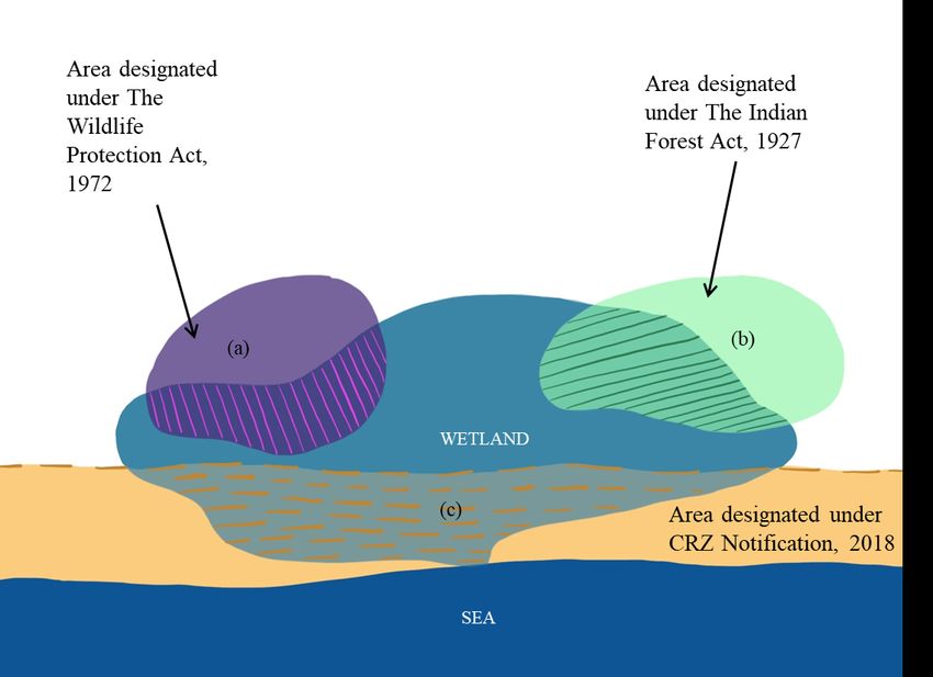
Contents
I.         Guidelines Purpose and Scope                                                                 2
II.        Wetlands to be regulated                                                                     2
III.       Wetlands Authorities                                                                         5
IV.        Preparing a list of wetlands                                                                 8
V.         Delineating wetlands                                                                         9
VI.        Delineating zone of influence                                                                10
VII.       Wetlands wise use and ecological character                                                   11
VIII.      Prohibited activities in a notified wetland                                                  13
IX.        Developing a list of activities, to be regulated in a notified wetland:                      13
X.         Developing a list of activities permitted in a notified wetland                              15
XI.        Registration of wetlands                                                                     15
XII.       Account of pre-existing rights and privileges in a notified wetland                          15
XIII.      Notifying wetlands                                                                           16
XIV.       Integrated Management Plan                                                                   17
XV.        Violations and penal provisions                                                              20
XVI.       Portal for information sharing                                                               21
Annexes
Annex 1:   Format for compiling list of wetlands                                                        22
Annex 2:   Format for preparing Brief Document                                                          23
Annex 3:    Format for draft notification of wetlands under Wetlands (Conservation and Management) Rules,
           2017                                                                                          31
Annex 4:   Steps and format for developing Integrated Management Plan                                   35
Annex 5:   Format for reporting status of notified wetlands                                             51

                                                         1
I. Guidelines Purpose and Scope
1. The Ministry of Environment, Forest and Climate Change (MoEF&CC) has notified Wetlands
(Conservation and Management) Rules, 2017 (hereinafter Wetlands Rules) under the provisions
of the Environment (Protection) Act, 1986 as regulatory framework for conservation and
management of wetlands in India. These guidelines have been drafted to support the State
Governments / Union Territory (UT) Administrations in the implementation of the Rules by
providing guidance on:
a) Preparing a list of wetlands in the State / UT
b) Identifying wetlands for notification under Wetlands (Conservation and Management) Rules,
2017
c) Delineating wetlands, wetlands complexes and zone of influence
d) Preparation of Brief Document
e) Determining ‘wise use’ and ecological character
f) Developing a list of activities to be regulated and permitted
g) Developing an Integrated Management Plan
h) Constitution and operational matters of the Wetlands Authorities
i) Overlapping provisions.
2. These guidelines were drafted by a committee constituted by the MoEF&CC vide OM dated
August 10, 2018. The committee comprised Mr U.A.Vora (former CCF Wildlife, Government
of Gujarat), Dr Arvind Kumar (President, India Water Foundation), Dr B.C. Jha (Former
Director (Wetlands), Central Inland Fisheries Research Institute), Dr P. S. N. Rao (Director,
School of Planning and Architecture), Dr Afroz Ahmad (Member, Environment and
Rehabilitation, Narmada Control Authority) and Dr Ritesh Kumar (Director, Wetlands
International South Asia). The committee met on five occasions at MoEF&CC, New Delhi for
the said purpose, and submitted final version of the guidelines to the Ministry on December 5,
2018. The draft guidelines were subsequently sent for comments to all State Governments / UT
Administrations, and have been finalized after due consideration of the comments received. The
Committee immensely benefitted from the discussions held with Ms Manju Pandey (Joint
Secretary). The Committee also acknowledges the support received from Ms Rita Khanna
(Scientist ‘F’), Dr M. Ramesh (Scientist ‘E’), Mr Chandan Singh (Scientist ‘D’), Dr Anu Chetal
(Research Assistant) and Ms Pallavi Mukherjee (Research Assistant) during the guidelines
preparation process.
II. Wetlands to be regulated
3. The provisions of Wetlands Rules apply to:
a) Wetlands designated by the Government of India to the List of Wetlands of International
Importance under the provisions of the Convention on Wetlands (Ramsar Convention).
[Ref. Rule 3 (a) of Wetlands Rule]
b) Wetlands notified under the rules by the Central Government, State Government and UT
Administration. [Ref. Rule 3 (b) of Wetlands Rule]
24. All wetlands, irrespective of their location, size, ownership, biodiversity, or ecosystem services
values, can be notified under the Wetlands Rules, except:
a) River channels;
b) Paddy fields;
c) Human-made waterbodies specifically constructed for drinking water purposes;
d) Human-made waterbodies specifically constructed for aquaculture purposes;
e) Human-made waterbodies specifically constructed for salt production purposes;
f) Human-made waterbodies specifically constructed for recreation purposes;
g) Human-made waterbodies specifically constructed for irrigation purposes;
h) Wetlands falling within areas covered under the Indian Forest Act, 1927; Forest
(Conservation) Act, 1980; State Forest Acts and amendments thereof;
i) Wetlands falling within areas covered under the Wildlife (Protection) Act, 1972 and
amendments thereof;
j) Wetlands falling within areas covered under the Coastal Regulation Zone Notification, 2011
and amendments thereof.
[Ref. Rule 2 (g) and Rule 3 of Wetlands Rules]
5. Human-made wetlands are defined as wetlands that are planned, designed and operated to meet
a specific purpose (such as providing water for irrigation, producing fish through culture
operations, producing salt, recreation, preventing salinity intrusion, flood control etc.). Only
those human-made wetlands that have been built for purposes, mentioned at paras 4c) – 4g)
above, are excluded from notification under these Rules.
6. Natural wetlands, partly or wholly used for purposes as mentioned at 4c) – 4g), attract the
provisions of the Wetlands Rules.
7. Wetlands designated as Ramsar Sites may be notified under the Rules as per the process
mentioned in paragraphs 57-65, even when partly or wholly overlapping with areas covered under
the Indian Forest Act, 1927; Forest (Conservation) Act, 1980; State Forest Acts and amendments
thereof; Wildlife (Protection) Act, 1972 and amendments thereof; Coastal Regulation Zone
Notification, 2011 and amendments thereof. Regulations for parts of wetlands overlapping with
4h-4j (supra) will, however, be as per the corresponding regulatory framework. Ramsar site areas,
not covered under any of the overlapping laws and rules, will attract the provisions of the
Wetlands Rules (Refer illustration 1 below).
3Illustration 1: Using the Wetlands Rules to fill in the gaps in situations of multiple regulations in a Ramsar
Site. In the situation above, wildlife sanctuary (indicated as a) and a reserved forest (indicated as b) partly
overlap with the Ramsar Site boundary. Being a coastal wetland, a part (indicated as c) also falls under
Coastal Regulation Zone. In such cases, it is recommended that the entire Ramsar Site, inclusive of
overlapping areas, is delineated and notified under the Wetlands Rules. The overlapping areas shall
continue to be regulated as per respective Acts and Rules, and the remaining area may be regulated as per
the provisions contained in Wetlands Rules. Similar approach can be taken even for wetlands that have
not been designated as Ramsar Site.
8. For wetlands falling within the criteria 3 (b) (supra), the exclusions mentioned at para 4 a) – 4j)
shall apply only in cases wherein the entire wetland falls under the said category. In cases wherein
areas falling within para 4 a) – 4 j) form a part of larger wetland or wetlands complex, and
exclusion may result in impeded ecological contiguity and connectivity, such areas may be
included within the boundary of wetland being notified. Regulations within the boundaries of
areas mentioned at para 4 h) – 4 j) will, however, be as per the corresponding regulatory
frameworks (Refer Illustration 1 and 2).
9. Though Protected Areas and areas falling within the purview of Coastal Zone Regulation have
been excluded from notification under the Wetlands Rules, management of such wetlands may
benefit through the application of ‘wise use’ approach (within the framework of existing laws and
rules) as outlined in Section VII of these guidelines.
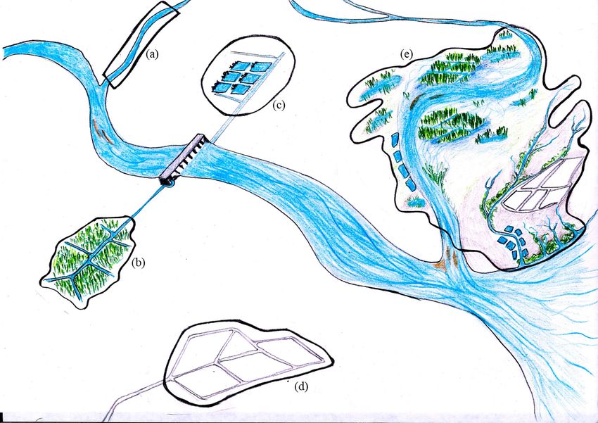
4Illustration 2: Considering river stretch and human-made wetlands for notification. In situations when the
entire wetland, to be notified, is a river stretch [indicated as (a)], paddy fields [indicated as (b)], human-
made wetland waterbodies for irrigation [indicated as (c)], and human-made waterbodies created for
aquaculture purposes [indicated as (d)], these may not be notified under the Wetlands Rules. However, in
cases as in (e), wherein river channels, paddy fields, and human-made wetlands such as aquaculture areas
form a part of a larger wetland or wetland complex, and excluding such area may fragment the wetland
regime, the area to be notified may include river channels, paddy fields or any other human-made wetland.
10. Should the State Governments/UT Administrations be desirous, any wetland, even if included
within the list of wetlands excluded from notification under Wetlands Rules, may be notified
under the relevant state laws. In this regard, the approach/mechanism outlined in Wetlands Rules
and these guidelines may be suitably adopted.
III. Wetlands Authorities
11. As per Rule 5 of Wetlands Rules, 2017 the Wetlands Authorities within States and UTs are
deemed as constituted with the following members:
a) Minister In-charge of the Department of Environment/Forests of the State Government or
Minister In charge of the Department handling wetlands - Chairperson;(Administrator or
Chief Secretary of the UT – Chairperson in the case of UT);
b) Chief Secretary of the State or Additional Chief Secretary equivalent - Vice Chairperson;
c) Secretary in-charge of the Department of Environment - Member ex-officio; (Vice-
Chairperson in the case of UT)
d) Secretary in-charge of the Department of Forests - Member ex-officio;
e) Secretary in-charge of the Department of Urban Development - Member ex-officio;
5f) Secretary in-charge of the Department of Rural Development - Member ex-officio;
g) Secretary in-charge of the Department of Water Resources - Member ex-officio;
h) Secretary in-charge of the Department of Fisheries - Member ex-officio;
i) Secretary in-charge of the Department of Irrigation and Flood Control - Member ex-officio;
j) Secretary in-charge of the Department of Tourism - Member ex-officio;
k) Secretary in-charge of the Department of Revenue - Member ex-officio;
l) Director, State Remote Sensing Centre - Member ex-officio;
m) Chief Wildlife Warden - Member ex-officio;
n) Member Secretary, State/UT Biodiversity Board - Member ex-officio;
o) Member Secretary, State Pollution Control Board/UT Pollution Control Committee -
Member ex-officio;
p) Additional Principal Chief Conservator of Forests of the Regional Office of Ministry of
Environment, Forest and Climate Change - Member ex-officio;
q) One expert each in the fields of wetland ecology, hydrology, fisheries, landscape planning
and socioeconomics to be nominated by the State Government / UT Administration
r) Additional Secretary/Joint Secretary/Director in the Department of Environment/Forests or
Department handling wetlands - Member Secretary
12. The Department of Environment / Forests or Department handling wetlands shall designate one
expert each in the following fields for a period not exceeding three years: [Ref. Rule 5 (2) (xvi) of
Wetlands Rules]
a) Wetlands ecology
b) Hydrology
c) Fisheries
d) Landscape planning
e) Socioeconomics
13. The Wetlands Authority may co-opt other members, not exceeding three in number. It is
recommended that at least one member may be drawn from civil society to enable stakeholder
representation.
14. The Authority shall exercise following powers and perform the following functions:
a) Prepare a list of all wetlands of the State or UT within three months from the date of
publication of these rules;
b) Prepare a list of wetlands to be notified, within six months from the date of publication of
these Rules, taking into cognizance any existing list of wetlands prepared/notified under other
relevant State Acts;
c) Recommend identified wetlands, based on their Brief Documents, for regulation under these
rules;
d) Prepare a comprehensive digital inventory of all wetlands within one year from the date of
publication of these rules and upload the same on a dedicated web portal, to be developed
by the Central Government for the said purpose; the inventory ought to be updated every
ten years;
e) Develop a comprehensive list of activities, to be regulated and permitted within the notified
wetlands and their zone of influence;
f) Recommend additions, if any, to the list of prohibited activities for specific wetlands;
g) Define strategies for conservation and wise use of wetlands within their jurisdiction;
h) Review Integrated Management Plan for each of the notified wetlands (including trans-
boundary wetlands in coordination with Central Government), and within these plans to
6consider continuation and support to traditional uses of wetlands that are harmonized with
ecological character;
i) Recommend mechanisms for maintenance of ecological character through promotional
activities for land within the boundary of notified wetlands or wetlands complex have private
tenancy rights,;
j) Identify mechanisms for convergence of implementation of the management plan with the
existing State/UT level development plans and programmes;
k) Ensure enforcement of these rules and other relevant Acts, rules and regulations and on a
half-yearly basis (June and December of each calendar year) inform the concerned State
Government or UT Administration or Central Government on the status of such notified
wetlands through a reporting mechanism;
l) Coordinate implementation of Integrated Management Plans based on wise use principle
through various line departments and other concerned agencies;
m) Function as a nodal authority for all wetland-specific authorities within the State or UT
Administration;
n) Issue necessary directions for the conservation and sustainable management of wetlands to
the respective implementing agencies.
o) Undertake measures for enhancing awareness within stakeholders and local communities on
values and functions of wetlands; and
p) Advise on any other matter suo-motu, or as referred by the State Government/UT
Administration.
[Ref. Rule 5 (4) of Wetlands Rules]
15. The State Government or UT Administration shall designate a department as nodal department
for wetlands. Such department shall provide all necessary support and act as Secretariat to the
Authority. The State Governments / UT Administrations may allocate sufficient budget and
human resources to ensure smooth functioning of the Authority and conduct of its various
activities. The Authority and the nodal department may identify a professional
institute(s)/organization(s) that would assist them in their various functions such as preparing a
list of wetlands, Brief Documents for notification etc.
16. The Authority shall meet at least thrice in a year. State Government / UT Administration may
decide an appropriate quorum, not less than half of the members. Minutes of meetings of the
Authority may be placed in the public domain within a period not exceeding two weeks from the
day on which meeting has been convened. [Ref. Rule 5 (2) (8) of Wetlands Rules]
17. Each Wetlands Authority shall constitute:
a) Technical Committee to review Brief Documents, Management Plans and advise on any
technical matter referred by the Wetlands Authority; and,
b) Grievance Committee, consisting of four members, to provide a mechanism for hearing and
forwarding the grievances raised by the public to the Authority.
[Ref. Rule 5 (6)(b) of Wetlands Rules]
18. The composition of these committees may be decided by the concerned State / UT Wetlands
Authority. Meetings of these committees shall be held at least once every quarter, and
proceedings presented in the next meeting of the Authority.
19. The Wetlands Authority may empower the Grievance Committee to redress grievances at the
local level and to recommend to the Authority for the finality of decisions. The State Government
7/ UT Administration may consider appointing at least one member with a legal background in
the Grievance Committee. [Ref. Rule 5(6)(b) of Wetlands Rules]
20. State or UT level Wetlands Authorities constituted before notification of Wetlands Rules, shall
be deemed dissolved for the purpose of these Rules.
21. State / UT Wetlands Authorities shall serve as nodal authority for authorities / agencies created
for specific wetlands. Management plans and notifications pertaining to the specific wetland shall
be subject to approval and endorsement of the State / UT Wetlands Authority. Administrative
matters, however, may continue to be dealt by the nodal department specified within the
constitution of the wetlands specific authority.
IV. Preparing a list of wetlands
22. The State / UT Wetlands Authorities are expected to prepare a list of wetlands within the
boundaries of their respective States / UTs. This list should be comprehensive, and not just focus
on wetlands that qualify for notification under these Rules. Therefore, it is recommended that
the list is developed based on wetlands definition of the Ramsar Convention (to which India is a
Contracting Party).
22.1 The Convention, ratified by Government of India, defines wetlands as ‘areas of marsh, fen,
peatland or water, whether natural or artificial, permanent or temporary, with water that is
static or flowing, fresh, brackish or salt, including areas of marine water the depth of which,
at low tides, does not exceed six meters’. In addition, to protect coherent sites, Article 2.1
of the Convention provides that ‘wetlands may include riparian and coastal zones adjacent
to the wetlands, and islands or bodies of marine water deeper than six meters at low tide
lying within the wetlands.’
23. The National Wetlands Atlas prepared by Space Application Center under the National
Wetlands Inventory and Assessment project, and available at
https://vedas.sac.gov.in/vedas/downloads/atlas/Wetlands/NWIA_National_atlas.pdf has spatial
data on wetlands for each State and UT.
23.1 The GIS data has already been made available by the Wetlands Division of the MoEF&CC
to the representatives of the State Governments / UT Administrations during the regional
consultation workshops held during 2016-18.
23.2 Wetlands Authority may seek the assistance of District Administration to validate the
information provided in the Atlas. Existing land records may also be considered while
developing the list of wetlands.
23.3 The final list of wetlands/wetland complexes may be prepared under the following heading:
a) Wetland Name
b) Geographical coordinates (latitude and longitude of the centre of the wetland)
c) Wetland type (inland and coastal) and sub-type (natural or human-made)
d) District(s) within which the wetland is located
e) Approximate area of the wetland
f) Whether the wetland falls within the category of regulated wetlands as per Wetlands
Rules.
8A format for compiling the list of wetlands is at Annex 1. This list may also contain trans-
boundary wetlands (at the end) with additional details such as the bordering State/UT under
which wetland is falling along with corresponding area.
24. In addition to the National Wetlands Atlas, it may also be helpful to consider the list of wetlands
studied and described by various agencies, including revenue records (particularly areas recorded
as any of the wetlands types such as ponds, lake, talab, sarovar etc.). The States/UTs may seek
the assistance of State Remote Sensing Agencies and local experts for preparing such wetland
inventory expeditiously. State Governments/ UT Administrations are also encouraged to make
use of satellite images available at National Remote Sensing Center’s Geo-platform Bhuvan,
accessible at http://bhuvan.nrsc.gov.in/data /download/index.php.
V. Delineating wetlands
25. After the wetlands have been identified for notifications under the Wetlands Rules, the next step
involves delineation of each of these wetlands (or wetlands complexes) and their zone of
influence.
26. For delineating wetlands, it is essential to be aware of the distinguishing characteristics of these
ecosystems. Wetlands arise when inundation by water produces soil dominated by anaerobic
processes, which in turn forces the biota, particularly rooted plants to adapt to flooding.
Wetlands, thus, have the following general distinguishing characteristics:
a) Permanent or periodic inundation or saturated soils throughout the year or during parts of
the year
b) Presence of macrophytes adapted to wet conditions (also known as hydrophytes)
c) Soil that are saturated or flooded long enough favouring development of anaerobic
conditions
27. Water creates wetlands. The biological composition of wetlands, from fish to migrating
waterbirds, depends on the ways water moves within a wetland. The amplitude and frequency of
water level fluctuations are probably the most critical factors affecting the composition and
functioning of wetlands. Hydrological regimes may, therefore, be used as the primary delineation
characteristics for defining wetland boundary.
28. Wetlands boundary can be derived as the outer envelope of the maximum area under
inundation, the area covered by hydrophytes, or saturation of soil near the surface during a
normal monsoon year. The boundary should be such that during a normal monsoon year, the
entire area is inundated for at least 15 days, or the soil is saturated roughly within one foot from
the surface. It may be pertinent to exclude areas that are only intermittently inundated in the
case of high floods (such as one in 100-year floods) or extreme events (such as storm surges of
extreme intensity).
29. Where two or more wetlands exist with a high degree on hydrological connectivity (for example,
wetlands connected during monsoon), or ecological connectivity (sharing waterbird habitats or
located on migratory fish pathways), these can be delineated as a single complex. In such cases,
non-wetland areas may be included within the boundary of the complex to ensure connectivity
and continuity. The connotation of wetland throughout this document includes wetlands
complex, as may be the case.
930. For each wetland and wetlands complex, a map should be prepared using a Geographical
Information System (WGS84 datum and UTM (Universal Transverse Mercator) projection) and
adopting professional cartographic standards. Essential features to be included in the map are as
follows:
a) Wetland boundary
b) The boundary of settlements located within and around the wetland
c) Connecting drainages, inflows and outflows
d) Main roads and railway (if any)
e) Major landmarks
31. Recommended scale for producing the wetlands maps is as follows:
Wetland / Wetlands complex area Recommended scale
Below 100 ha 1: 4000
Between 100 – 500 ha 1: 10,000
Between 500- 4000 ha 1: 25,000
4000 ha and above 1: 50,000
These scales have been recommended on the basis of spatial data available for preparing wetlands maps
and details that may be extracted for management planning and monitoring decisions. Resources at 2 LISS
IV data that may be used for preparing map of wetlands below 100 ha renders an approximate scale of
1:4000. Even larger wetlands can be mapped using finer resolution data. However, for expedience and
cost effectiveness, a lower scale may be sufficient for meeting management needs.
VI. Delineating zone of influence
32. For each wetland to be notified, a zone of influence is to be defined. The zone of influence of a
wetland is an area, developmental activities wherein are likely to induce adverse changes in
wetland ecosystem structure and (ecological) functioning.
33. The boundary of the zone of influence may be defined with due consideration to local hydrology
and nature of land use. For wetlands with a well-defined surface drainage system, its directly and
freely draining basin should be delineated as the zone of influence. This can be done using a
suitable digital elevation model data and validated using toposheets. The basin should encompass
all direct inflow as well as outflow areas. The river basin atlas of India (available at
http://www.india-wris.nrsc.gov.in/wrpinfo/ index.php?title=WRIS_Publications) may be used to
support the delineation.
34. For wetlands with diffused drainage and where the slope is too gentle leading to large basin area,
the zone of influence can be delineated on the basis of features that are likely to influence wetland
functioning adversely. These could be based on the outer periphery of adjoining settlements, or
peripheral agricultural fields that drain directly into the wetland.
35. A map should be prepared to indicate the following elements in a Geographical Information
System (WGS84 datum and UTM projection) and adopting professional cartographic standards:
a) Zone of influence
b) Wetland boundary
10c) Connecting drainages, inflows and outflows
d) Main roads and railway (if any)
e) Major landmarks
36. The recommended scale at which the map of the zone of influence is to be produced is as follows:
Area of zone of influence Recommended mapping scale
Below 100 ha 1: 4000
Between 100 and 500 ha 1: 10,000
More than 500 ha 1: 50,000
VII. Wetlands wise use and ecological character
37. Management of notified wetlands is recommended to be based on ‘wise use’ approach. Human
beings and their use of resources form an essential component of wetland ecosystem dynamics.
The ‘wise use’ approach recognises that restricting wetland loss and degradation requires
incorporation of linkages between people and wetlands. The wise use principle emphasises that
human use of these ecosystems on a sustainable basis is compatible with conservation.
38. Ramsar Convention defines the ‘wise use’ of wetlands as “the maintenance of their ecological
character, achieved through the implementation of ecosystem approaches, within the context of
sustainable development”. Ecosystem approach requires consideration of the complex
relationship between various ecosystem elements and promotion of integrated management of
land, water and living resources. Wise use, through an emphasis on sustainable development,
calls for resource use patterns which can ensure that human dependence on wetlands can be
maintained not only in the present but also in the future. Seen in totality, wise use is about
maintaining and enhancing wetland values and functions to ensure the maintenance of the flow
of benefits from wetlands (their ecosystem services) from an inter-generational equity point of
view.
39. Ecological character is “the combination of ecosystem components, processes and services that
typify the wetland at a given point in time”. Ecosystem components are living (biotic) and non-
living (abiotic) constituents of the wetland ecosystem. These include:
a. Geomorphic setting (landscape, catchment, river basin);
b. Climate (precipitation, wind, temperature, evaporation, humidity);
c. Physical setting (area, boundaries, topography, shape, bathymetry, habitat type and
connectivity);
d. Water regime (inflow, outflow, balance, surface-groundwater interactions, inundation
regime, tidal regime, quality);
e. Wetland Soil (texture, chemical and biological properties);
f. Biota (Plant and animal communities)
40. Ecosystem processes occur between organisms and within and between populations and
communities, including interactions with the non-living environment that result in an existing
ecosystem state and bring about changes in ecosystems over time. These include: Physical
processes (water stratification, mixing, sedimentation, erosion); Energy – nutrient dynamics
(primary production, nutrient cycling, carbon cycling, decomposition, oxidation-reduction);
11Processes that maintain animal and plant population (recruitment, migration); and Species
interaction (Competition, predation, succession, herbivory).
41. Ecosystem services are benefits obtained by humans from ecosystems, categorized as:
Provisioning (fisheries, use of aquatic vegetation for economic propose, wetland agriculture,
biochemical products); Regulating (maintenance of hydrological regimes) and Cultural
(recreation and tourism, spiritual, scientific and educational value). Supporting services are
included within ecosystem processes.
42. A wetland use is not ‘wise-use’ if:
a. The intervention leads to adverse changes in ecosystem components and processes, such as:
i. Reduction in water flowing into the wetlands
ii. Reduction in the area under inundation, or changes in inundation regime
iii. Reduction and alteration of natural shoreline
iv. Fragmentation of wetlands into small patches of water
v. Reduction in water holding capacity
vi. Degradation of water quality
vii. Reduction in diversity of native species
viii. Introduction or emergence of invasive species
ix. Decline in wetlands resources, such as fish, aquatic plants, and water
b. The intervention enhances some ecosystem services (such as food production values) while
diminishing other ecosystem services (such as the ability of wetlands to moderate wetlands
regime).
43. Some examples of wetlands uses that may not be ‘wise-use’ are as follows:
Type of Intervention Ecosystem services likely Ecosystem services
wetland to be enhanced likely to be diminished
Lagoon Prawn aquaculture by • Food provision • Water regime
creating enclosures within • Livelihoods for moderation
the lagoon area wetlands dependent • Flood buffering
communities
Lake Impounding water by Increased water • Ability to moderate
regulating outflows availability for human use floods
Marsh Construction of road Transport • Hydrological
connecting settlements regime moderation
located on the periphery • Flood buffering
• Aesthetics
Urban Concretization of shoreline • Aesthetic value • Ability to
lake for beatification • Tourism and accommodate
recreational benefits monsoon flows
• Habitat values
44. In several cases, the impact on ecosystem structure and functions, or tradeoffs in ecosystem
services may not be immediately apparent. It is, therefore, recommended that the ‘precautionary
12approach’ is adopted to ensure that wetlands conservation is prioritized in the case of information
uncertainty.
VIII. Prohibited activities in a notified wetland
45. The following activities are prohibited within notified wetlands:
a. Conversion for non-wetland uses including encroachment of any kind;
b. Setting up of any industry and expansion of existing industries;
c. Manufacture or handling or storage or disposal of construction and demolition waste covered
under the Construction and Demolition Waste Management Rules, 2016; hazardous
substances covered under the Manufacture, Storage and Import of Hazardous Chemical
Rules, 1989 or the Rules for the Manufacture, Use, Import, Export and Storage of
Hazardous Microorganisms/Genetically Engineered Organisms or cells, 1989 or the
Hazardous Wastes (Management, Handling and Transboundary Movement) Rules, 2008;
electronic waste covered under the E-Waste (Management) Rules, 2016;
d. Solid waste dumping;
e. Discharge of untreated wastes and effluents from industries, cities, towns, villages and other
human settlements;
f. Any construction of a permanent nature except for boat jetties within fifty metres from the
mean high flood level observed in the past ten years calculated from the date of
commencement of these rules; and,
g. Poaching.
[Ref. Rule 4 (2) of Wetlands Rules]
46. State/UT Wetlands Authority, based on consideration of site-specific conditions, may consider
expanding the list of prohibited activities for a notified wetland (or wetlands complex). This
should be specified as such within the notification for specific wetland (or wetlands complex).
47. Permission for carrying out any activity included within the list of prohibited activities [as per
Rule 4(2) of Wetlands Rules], within a notified wetland can only be given by the MoEF&CC. A
specific request needs to be made by the State Government based on the recommendation of
Wetlands Authority specifying:
a) Activity for which permission is sought;
b) Justification thereof;
c) The premise on which the activity is not considered detrimental to the wetland’s ecological
character; &
d) Supporting evidence-base (such as an expert report, EIA, mitigating measures proposed to
be undertaken etc.)
IX. Developing a list of activities, to be regulated in a notified wetland:
48. Activities within a notified wetland and its zone of influence, which when contained within a
specific threshold or area, are not likely to induce an adverse change in wetlands ecological
character may be placed under the ‘regulated’ category. Such activities should be notified within
the notification for a specific wetland (wetlands complex).
49. Following activities, when regulated, are not likely to induce an adverse change in wetlands:
a) Subsistence level biomass harvesting (including traditional practices);
13b) Sustainable culture fisheries practices (in private lands);
c) Plying of non-motorized boats;
d) Desilting, in case where wetlands inflow regimes and water-holding capacity are impacted by
siltation (note that ‘deepening’ activities are not the same as ‘desilting’); &
e) Construction of temporary nature
50. Each activity, however, would need to be considered on a case to case basis keeping in mind the
ecological character of wetland or wetlands complex. A generic listing of a set of activities for all
wetlands of the State / UT may not be feasible or desirable. For example, releasing treated sewage
may not be advisable for high altitude wetlands that have slow decomposition rates.
51. For each regulated activity, it may be desirable to set a threshold limit beyond which the activity
may be prohibited. The thresholds can be in the form of a spatial limit (such as areas wherein
capture fishing may be carried), temporal limits (such as observing closed season), ecological
condition (such as maintenance of a water quality parameter within a prescribed range), number
of people (such as number of tourists permitted to visit the wetland on a given day), land use
(such as prohibiting use of intermittently inundated area for permanent agriculture, or
construction of enclosure), or any relevant dimension. Some examples of thresholds are:
Activity (Indicative List) Aspect on which threshold can be specified
a) Subsistence level biomass harvesting • Number of people that can be permitted to
(including traditional practices) harvest biomass within the wetlands
• Type of harvesting gears (mesh size) and crafts
• Area wherein harvesting is permitted
b) Releasing of treated sewage Water quality parameters (such as):
• Dissolved Oxygen,
• Biological Oxygen Demand
• Chemical Oxygen Demand
• Concentration of heavy metals
• Coliforms
c) Sustainable culture-based fisheries • Area wherein culture-based fisheries is
practices permitted
• Stocking density
• Water quality
d) Plying of non-motorized boats • Area wherein plying is permitted
• Number of boats
e) Desilting, in cases where wetlands • Area wherein desilting can be carried out
inflow regimes and water holding
capacity are impacted by siltation
f) Noise Pollution • Limiting below level suited for waterbird
habitat
g) Washing and bathing activities • Use of detergent
h) Construction of temporary nature • Area wherein temporary constructions can be
carried out
14• The period for which such structure can be
maintained inside the notified wetlands
i) Change in landuse pattern within the • Land use does not alter the hydrological
zone of influence regime or interrupt species interactions (such
as bird migration pathways)
52. The Wetlands Authority shall be responsible for enforcing the regulations, through enforcement
machinery of the concerned State Government / UT Administration.
X. Developing a list of activities permitted in a notified wetland
53. Activities aligned with the ‘wise use’ of wetland may be permitted within the wetland (wetlands
complex) or its zone of influence. The following activities are likely to be aligned with the ‘wise
use’ approach:
a) Ecological rehabilitation and rewilding of nature ;
b) Wetlands inventory, assessment and monitoring;
c) Research;
d) Communication, environmental education and participation activities;
e) Management planning;
f) Habitat management and conservation of wetland-dependent species;
g) Community-based ecotourism (with minimum construction activities);
h) Harvesting of wetlands products within regenerative capacity; and,
i) Integrating wetlands as nature-based solutions for climate change mitigation and adaptation.
54. Permitted activities may need to be identified considering the ecological character of each
wetland to be notified. It is likely that an activity may be benign for one wetland, yet would need
regulation for others. For example, ecotourism may not be desirable for all wetlands.
XI. Registration of wetlands
55. It is advised that the State/UT governments may ascertain whether the respective wetland has
been registered appropriately in the land revenue records. If the wetland has not been registered
as yet, necessary steps may be taken early. This would help in ensuring that the usage of wetland
is not altered in future through encroachment, illegal claim of ownership etc.
XII. Account of pre-existing rights and privileges in a notified wetland
56. Each wetland is likely to be associated with a range of pre-existing rights and privileges, and it
must be ensured that such rights and privileges are aligned with the ‘wise use’ approach. ‘Privilege’
is defined here as a special entitlement granted to restricted group or persons, on a conditional
basis and can be revoked. ‘Rights’, on the other hand, may be irrevocable and inherently held by
a human being. Thus, a fish lease granted in certain wetlands by the Department of Fisheries can
be considered as a privilege. Privilege can also be customary and traditional (for example, the use
of traditional fishing techniques, buffalo wallowing, elephant bathing, the source of drinking water
for bovines, etc.). Parking a houseboat against a lease right to clean environment are examples of
rights.
1557. For assessing the consequence of a pre-existing right or privilege on a wetland, it may be
important to consider their implication on wetland ecological character. The privilege of fishing
granted along a migratory route can lead to an adverse change in fish stocks. Similarly, the
disposal of untreated sewage by houseboat in a wetland can lead to pollution. Thus, such
privileges are not aligned with ‘wise use’. On the other hand, in many cases, the subsistence level
harvest of macrophytes may help in keeping species invasion in check and therefore aligned with
ecosystem health. Such considerations may need to be made while deciding whether a wetland
use is to be regulated or permitted.
XIII. Notifying wetlands
58. For each wetland proposed to be notified, a ‘Brief Document’ containing the following
information needs to be prepared:
a) Demarcation of wetland boundary, supported by accurate digital maps with coordinates and
validated by ground truthing;
b) Demarcation of its zone of influence alongwith land use and land cover thereof indicated in
a digital map;
c) Ecological character description;
d) Account of pre-existing rights and privileges;
e) List of site-specific activities, to be permitted within the wetland and its zone of influence;
f) List of site-specific activities, to be regulated within the wetland and its zone of influence; and,
g) Modalities for enforcement of regulation.
A format for preparing the Brief Document is at Annex 2.
59. The nodal department, designated by the State Government/UT Administration for wetlands,
shall be responsible for preparing the Brief Documents.
60. In the case of transboundary wetlands, the respective State Governments/UT Administration
may initiate the process of preparation of a common Brief Document and submit the same to
MoEF&CC. If required, MoEF&CC shall coordinate with the concerned State Governments/UT
Administrations for preparation of the Brief Document and addressing relevant issues. The
Ministry will further process Brief Document as per process laid under Rule 7(4) of Wetlands
Rules, 2017.
61. All Brief Documents shall be placed for approval of the Wetlands Authority. The Authority may
endorse the Brief Document for notification to the concerned State Government / UT
Administration.
62. The State Government / UT Administration shall issue a draft notification indicating the wetland
(wetlands complex) to be covered under the Wetlands Rules. The notification should contain:
a) Description of the wetland (wetlands complex) boundary along with its map
b) Description of the zone of influence along with a map
c) List of activities prohibited within the wetland (wetlands complex) and its zone of influence
d) List of activities regulated within the wetland (wetlands complex) and its zone of influence
e) List of activities permitted within the wetland (wetlands complex) and its zone of influence
f) Name and contact details of the nodal person, who is to be contacted for seeking permission
to undertake regulated activities.
16A format for notification is at Annex 3.
63. Each draft notification shall be placed for public consultation for sixty days.
64. The State Government after considering objections from the concerned and affected persons
shall publish the final notification within a period not exceeding 240 days from the date of draft
notification.
65. MoEF&CC shall issue the draft and final notification for transboundary wetlands.
66. All Ramsar Sites, deemed covered under these Rules, shall also be notified as per the process
laid out in paragraphs 57-64. This is proposed to ensure that the site boundaries are properly
delineated and the knowledge about the same is available in public domain. It is adused that the
information in the ‘Brief Document’ may be consistent with Ramsar Site Information Sheet
(RSIS), submitted to the Ramsar Convention during site designation or RSIS updated thereafter.
XIV. Integrated Management Plan
67. Wetlands are one of the most embedded and interlinked ecosystems with human livelihoods
and well-being. A balanced management approach, addressing biodiversity conservation values
while providing for sustainable utilisation in a way compatible with the maintenance of natural
properties of the ecosystem, needs to be adopted for these ecosystems. It is, therefore,
recommended that management of each notified wetland (is guided by an “Integrated
Management Plan”. The plan refers to a document which describes strategies and actions for
achieving ‘wise use’ of the wetland and includes objectives of site management; management
actions required to achieve the objectives; factors that affect, or may affect, various site features;
monitoring requirements for detecting changes in ecological character and for measuring the
effectiveness of management; and resources for management implementation. Besides
identifying resources, a management plan serves several important functions including generating
baseline information, communication with stakeholders and ensuring compliance with regulatory
frameworks and policy commitments.
68. While it is recognized that each wetland has its own distinctive ecological and hydrological
features and thereby distinctive management needs, the following broad planning principles need
to be kept in mind while formulating integrated management plans:
• Integrated planning: Aquatic and terrestrial ecosystems are intimately linked by the process
of the water flowing through them. Every land use decision has a consequence on water
availability. Delineating a basin or a coastal zone enables demarcation of a distinct
hydrological unit which is the natural integration of all hydrological processes within its
boundary and therefore an ideal and rational unit for soil, water and bio-resources
conservation and management.Thus, management planning for wetlands should not be
restricted to a defined administrative boundary, but rather take into account wider planning
and management context of the basin or coastal zone within which the site is located.
The process of development and implementation of management plans for wetlands often
needs to be accompanied by governance improvements at basin and coastal zone level.
Such an approach underpins Integrated Lake Basin Management framework that calls for
17achieving ‘sustainable management of wetlands through gradual, continuous and holistic
improvement of basin governance, including sustained efforts for integration of institutional
responsibilities, policy directions, stakeholder participation, scientific and traditional
knowledge, technological possibilities, and funding prospects and constraints.
Achieving close relationship between planning and governance is critical, considering
multiple stakeholder and sectoral interests which underlie and, to a large extent, structure
wetland biodiversity and ecosystem service values, and the need to secure people’s
involvement and participation in basin-scale management for considerably long periods of
time.
Reflection upon the following six pillars of basin-scale governance may thus be useful:
• Institutions: Development of effective organisations and governance frameworks
• Policies: Setting broad directions and specific rules
• Participation: Expanding the circle of involvement
• Technology: Possibilities and limitations
• Information: Pursuing sources of knowledge and wisdom, and
• Finance: Seeking sustainable sources at the appropriate level
• Use of diagnostic approaches for defining management approach and actions: Given the
uniqueness associated with each wetland, it is important that ‘one size fit all’ approach is
replaced with a diagnostic approach, wherein the ecological, hydrological, socioeconomic
and institutional features are comprehensively assessed and trends therein determined to
be able to spell out management objectives and actions clearly.
• Adaptable management: Wetlands are influenced by a range of drivers and pressures that
act at multiple spatial, temporal and political scales. Their management plan, therefore,
needs to be accommodative of uncertainties and challenges. This can be achieved by using
an adaptable management approach that allows for suitable modification of management
based on continuous site monitoring and assessment of new information.
• Stakeholder participation: The condition of any wetland is an outcome of actions by a range
of stakeholders, which are linked to the ecosystem in a number of ways. Management
planning, therefore, needs to recognise these linkages, and build a mechanism for
participation of stakeholders in design, review and implementation processes.
• Governance: Being located at the interface of land and water, wetlands are influenced by a
range of developmental activities that take place within their direct and indirect basins and
coastal zones. Institutional arrangements for managing wetlands need to be such that they
are capable of integrating activities across multiple sectors (such as agriculture, water
resources, forests, rural development, urban development, forests and wildlife and others),
and balancing the needs of a group of diverse stakeholders while ensuring that ecological
integrity of these fragile ecosystems is not adversely affected.
In the above context, association of entities or individuals as ‘Wetland Mitras’ can
encourage stakeholder participation and overall governance.
69. An integrated wetlands management plan can be developed in the following steps, thus enabling
a systematic diagnosis of wetlands features and their governing factors to arrive at management
objectives and activities.
18Step 1 Preamble Concise policy statement describing the rationale for the
application of human, technical and financial resources for the
wetland management
Step 2 Description of Collation and synthesis of data to describe: wetland location and
wetland features extent, catchment, hydrological regimes, biodiversity, ecosystem
services, socioeconomic and livelihoods
Step 3 Evaluation of Based on the description of features, identification of priority
wetland features wetland features that need to be maintained, and key threats that
adversely affect these features
Step 4 Institutional • Provide an overview of the current institutional
arrangements arrangements in the context of wetlands management;
• Discuss why the current institutional arrangements are
insufficient in ensuring wetlands conservation and wise use;
• Propose institutional arrangement for wetland management,
with specific focus on:
a) Nodal Agency
b) Role of various departments and agencies and
coordination mechanism, and
c) Role of civil society and communities.
• Develop an organogram for management plan
implementation.
• Regulatory regime specifying activities prohibited within
wetlands, activities to be regulated within wetlands and zone
of influence and regulation thresholds and activities
permitted
Step 5 Setting • Provide a statement of the overall goal that the management
Management plan seeks to achieve;
Objectives • Summarize the ecological and economic benefits that are
expected from management plan implementation;
• Enlist specific objectives;
• Describe strategy(ies) for achieving each of the management
objectives;
• Provide a strategy for implementing regulatory regime –
including list of activities liable to be prohibited, regulated
and permitted within the wetland (wetlands complex)
Step 6 Monitoring and • Present an overview of monitoring the wetland, and
Evaluation Plan management plan implementation;
• Describe monitoring parameters, the frequency of
monitoring and the agency that will be responsible for
monitoring;
• Describe how coordination between different monitoring
agencies will be achieved;
• Discuss the infrastructure and human resource requirement
for implementing the management plan. (As far as possible,
include local universities, research organizations and NGOs
in wetlands monitoring);
• Discuss the frequency in which reporting shall be done and
the responsible agency; Discuss how the monitoring
outcomes will be used to adapt management
Step 7 Action Plan Listing of management components and specific activities to
achieve management objectives. For each activity,
19implementation location, prioritisation, implementing agency
and timeline should be specified.
Step 8 Budget Assessment of financial resources required for implementing the
management plan and sources of funds.
A description of each step and format for the compilation of integrated management plan is at
Annex 4.
70. The management plans should be presented to the Wetlands Authority. The implementation
shall begin only after receiving their endorsement. Management plans for Ramsar Sites and
transboundary wetlands shall also be reviewed and endorsed by the MoEF&CC.
71. The diagnostic management planning process, as described above, may also be used to guide
management of wetlands excluded from notification under Wetlands Rules.
XV. Violations and penal provisions
72. The Wetlands Authorities are entrusted with the responsibility of ensuring enforcement of
Wetlands Rules and other relevant Acts, Rules and Regulations. Provisions of the relevant
Central and State Government Acts are applicable.
73. All prohibited and regulated activities beyond their thresholds, if taken up within the wetlands
and its zone of influence, shall be deemed violations under the Wetlands Rules.
74. The violations of the Wetlands Rules shall attract the penal provisions as per the Environment
(Protection) Act, 1986.
75. Complaints may need to be filed in the case of violations. In exercise of powers conferred under
clause (a) of section l9, the Central-Government has authorised the officers and authorities listed,
in the Table (p. 238) vide S.O. 394 (E) published in the Gazette No. 185 dated 16-4-87, S.O.
237(E) published in Gazette No. 171 dated 29-3-89 and S.O. 656(E) published in the Gazette
No. 519 dated 21-8-89, and amendments thereafter, if any.
76. The Authority should evolve a mechanism for continuous watch and ward of wetlands within
their jurisdiction. At the local level, the concerned Gram Panchayat and Urban Local Body may
be entrusted with watch and ward in association with any body constituted by the State Wetlands
Authority, such as a Wetlands Management Unit for a specific Wetland. At District levels, the
responsibility may be entrusted to the DDO/CDO (District/Chief Development Officer)/CEO
(Chief Executive Officer)/ Chief Programme Officer of the Wetland level body, such as a
Wetlands Management Unit.
77. The State Governments should proactively ensure incorporation of wetlands within land records.
78. The Wetlands Authority shall report the status of notified wetlands on half yearly basis to the
State Government/UT Administration and Central Government (recommended proforma at
Annex 5).
20XVI. Portal for information sharing
79. The MoEF&CC has created a web-portal for sharing information regarding implementation of
Wetlands Rules. The portal may be accessed at MoEFCC website. The Central Government,
State Government and UT Administration are required to upload all relevant information and
documents pertaining to wetlands in their jurisdiction. State Governments / UT Administrations
are encouraged to develop their own portals and hyperlink the same to the national portal. The
State Governments and UT Administrations are also encouraged to upload other project
documents and publications to enable sharing and exchanging good practices related to wetlands
management in general, and implementation of regulatory framework in particular.
21Annexes
Annex 1: Format for compiling list of wetlands
S. Wetland Geographical District (s) Village Wetlands Wetlands Area Khasra Whether falls
No. Name coordinates in which type sub-type (ha) or within category
the wetland Survey of regulated
is located numbers wetlands as per
Wetlands
Rules
(latitude and (inland or (natural or
longitude of coastal) human-
the centre of made)
the wetlands)
Total no. of wetlands:
Total no. of wetlands to be regulated/notified under Wetlands Rules:
22Annex 2: Format for preparing Brief Document
State / Union Territory: ___________________________________
Name and address of person(s) compiling this information___________________________________
Section 1: Identification, Location and Jurisdiction
1.1 Name of the Wetland (Alternative names, including in local language should be given in
parenthesis after official name)
____________________________________________________________________________
1.2 Name of the Village(s) , Tehsil(s), Municipal area (s)
____________________________________________________________________________
1.3 Name of the District(s) in which wetland complex is located
____________________________________________________________________________
1.4 Geographical coordinates (Latitude and Longitude, to degree, minutes and second)
Latitude: From ______________________________ to _______________________________
Longitude: From _____________________________ to _______________________________
1.5 Name of the Department / Agency which has jurisdiction over the wetland / wetlands complex
____________________________________________________________________________
Section 2: Site Characteristics
2.1 Area of wetland / wetlands category (ha) ___________________________________
2.2 Wetland type (Please tick appropriate categories and sub-categories)
Category Subcategory
r Natural (Inland) r Permanent lakes
r Seasonal/ intermittent lakes
r Permanent streams/ creeks
r Seasonal/ intermittent streams/ creeks
r Oxbow
r River floodplain
r Permanent freshwater marshes
r Seasonal/ intermittent freshwater marshes
r Shrub-dominated wetlands
r Tree-dominated wetlands
r Geothermal wetlands
r Karst and other subterranean hydrological systems
23r Natural (Coastal) r Coastal lagoon
r Estuary
r Intertidal mud, sand or salt flats
r Mangroves
r Coral reefs
r Human-made r Aquaculture pond
r Tank
r Saltpan
r Dam / Reservoir
2.3 Depth (m) Average ________________________ Maximum ______________________
2.4 Elevation (m above mean sea level)______________________ m
2.5 Water regimes
a) Main source of water (tick all applicable)
r Rainfall r Groundwater r Catchment runoff r Direct / indirect inflow from river
r Others, please specify_____________________________
b) Water permanence
r Mostly permanent r Mostly intermittent
c) Destination of water from wetland
r Feeds groundwater r To downstream catchment r To river r To sea
d) Water pH
r Acid (< 5.5) r Circumneutral (5.5 – 7.4) r Alkaline (> 7.4)
r Not known
e) Water salinity
r Fresh (< 0.5 g/l) r Brackish (0.5 – 30 g/l)) r Euhaline (30- 40 g/l)
r Hypersaline (>40g/l) r Not known
f) Nutrient in water
r Eutrophic r Mesotrophic r Oligotrophic
r Not known
2.6 Climatic setting
24You can also read


