COMPREHENSIVE PLAN, 2016-2035 CITY OF NICHOLSON, GEORGIA
←
→
Page content transcription
If your browser does not render page correctly, please read the page content below
COMPREHENSIVE PLAN, 2016-2035
 CITY OF NICHOLSON, GEORGIA

       Adopted August 1, 2016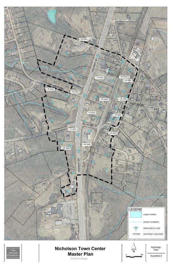
City of Nicholson, GA, Comprehensive Plan, 2016-2035

                            Nicholson Mayor and City Council (2016)

                                        Jan Webster, Mayor
                                           Mike Barfield
                                            Judy Kesler
                                          Lamar Watkins
                                           Max Whitlock

                                     Debra Fontaine, City Clerk

                                Nicholson Planning Commission

                                       John Ring, Chairman
                                    Roger Cosby, Vice Chairman
                                      Mike Stowers, Secretary
                                          Bobby Russell
                                           Jenny Guest

                     Nicholson Comprehensive Plan Steering Committee

                              Jan Webster              Roger Cosby
                              Mike Barfield            Mike Stowers
                             Lamar Watkins             Bobby Russell
                              Max Whitlock              Jenny Guest
                              Judy Kesler               Doug Kesler
                               John Ring                Dusty Durst

                                       Planning Consultant

                                   Jerry Weitz, FAICP, Principal
                                  Jerry Weitz & Associates, Inc.
                               Planning & Development Consultants
                                        Alpharetta, Georgia

                        Geographic Information Systems (GIS) Support

                                 Joel Logan, GISP, Director
                 Jackson County Department of Geographic Information Systems

                                                   2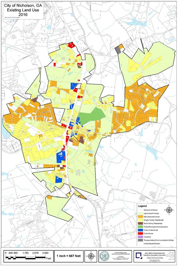
City of Nicholson, GA, Comprehensive Plan, 2016-2035

                                             CONTENTS

 CHAPTER 1. BACKGROUND AND INTRODUCTION                 5

 PURPOSES                                               5
 ORGANIZATION                                           5
 PLANNING HISTORY                                       5
 PLANNING REQUIREMENTS                                  6
 ABOUT NICHOLSON                                        6

 CHAPTER 2. NEEDS AND OPPORTUNITIES                     7

 HOUSING AND POPULATION                                  7
 ECONOMY                                                 9
 NATURAL AND CULTURAL RESOURCES                          9
 COMMUNITY FACILITIES AND SERVICES                      10
 LAND USE AND DEVELOPMENT MANAGEMENT                    13
 TRANSPORTATION                                         13
 BEAUTIFICATION AND AESTHETICS                          16

 CHAPTER 3. POLICIES                                    18

 ANNEXATION                                             18
 ENVIRONMENT AND NATURAL RESOURCES                      18
 HOUSING                                                20
 ECONOMIC DEVELOPMENT                                   21
 LAND USE – GENERALLY                                   22
 LAND USE – TOWN CENTER                                 22
 LAND USE – HIGHWAY BUSINESS                            23
 TRANSPORTATION                                         23
 INTERGOVERNMENTAL COORDINATION                         24

 CHAPTER 4. LAND USE                                    26

 LAND USE CLASSIFICATION                                26
 Vacant/Undeveloped                                     26
 Park/Recreation/Conservation                           26
 Agricultural/Forestry                                  27
 Residential Subcategories                              27
 Rural Residential                                      27
 Suburban Residential                                   28
 Public/Institutional                                   28
 Commercial (Town Center and Highway Business)          28
 Transportation/ Communications/ Utilities              29
 EXISTING AND FUTURE LAND USE                           32

 CHAPTER 5. COMMUNITY WORK PROGRAM                      35

 REFERENCES                                             38

                                                   3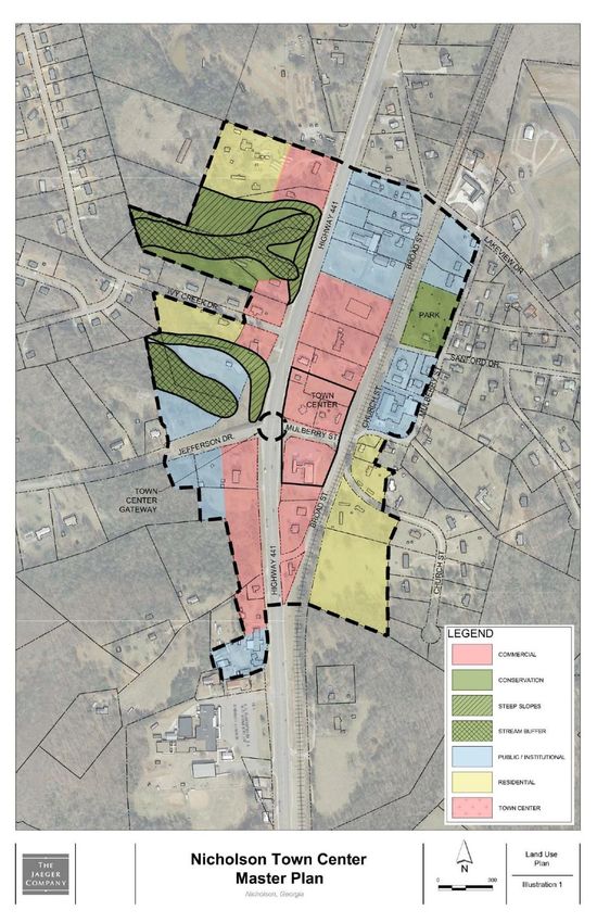
City of Nicholson, GA, Comprehensive Plan, 2016-2035

 APPENDIX A. Report of Accomplishments, 2010 Comprehensive Plan                     39
 2009-10 to 2014-15 Short-Term Work Program

 APPENDIX B. SELECTED PUBLIC PARTICIPATION INFORMATION                              41

                                       FIGURES AND MAPS

 Nicholson Water Authority, Generalized Service Area                                11
 Hydrology Plan, Nicholson Town Center                                              12
 Sidewalk Extension Plan for Town Center                                            15
 Long-Range Regional Bicycle Loop Route                                             16
 Gateway Signage, Town Center                                                       17
 Land Use Plan, Town Center                                                         29
 Building Placement and Landscaping, Town Center                                    30
 Town Center Park Plan                                                              31
 Existing Land Use, Nicholson                                                       33
 Future Land Use Plan, Nicholson                                                    34

                                              TABLES

 Table 2.1    Population and Housing Unit Forecasts, 2010-2030, City of Nicholson    8
 Table 4.1    Land Use Acreage by Land Use Category, 2015 and 2035                  32
 Table 5.1    Community Work Program, 2016-2021, City of Nicholson                  36
 Table 5.2    Long-Range Projects, City of Nicholson                                37

                                                   4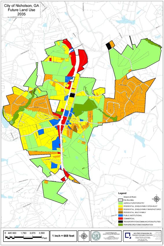
City of Nicholson, GA, Comprehensive Plan, 2016-2035

                                      CHAPTER 1
                              BACKGROUND AND INTRODUCTION

PURPOSES

The comprehensive plan is first, a physical plan intended to guide the physical development and
redevelopment of the city by describing how, why, when, and where to build, rebuild, or
preserve aspects of the community. Second, the comprehensive plan covers a long-range
planning horizon of 20 years (i.e., to the year 2035). Third, the comprehensive plan is
“comprehensive” in the sense that it covers the entire city limits, plus it encompasses all the
functions that make a community work and considers the interrelatedness of functions. The
comprehensive plan is based on the foundation that if the city knows where it wants to go, it
possesses better prospects of getting there. Without looking ahead 20 years or more and
articulating what it will need and what residents want the city to become, it is difficult for a city to
foresee how it can reach its goals.

The ultimate client, for the comprehensive plan is the Nicholson Mayor and City Council. By
adopting the comprehensive plan, the Mayor and City Council have made an extremely
important expression of their consent and support for the policies and work program contained
in this plan. Completion of the comprehensive planning process according to state rules allows
a local government to maintain its Qualified Local Government (QLG) status and, thus, maintain
its eligibility to receive certain state grants and loans.

ORGANIZATION

This comprehensive plan is organized into five chapters and two appendices. The first chapter
(this one) provides background and introduces the comprehensive plan document. Chapter 2
analyzes and describes all of the “needs and opportunities” which were identified and refined
during the community participation process. Chapter 3 provides the city’s goals and policies.
Chapter 4 is the city’s land use element. Chapter 5 focuses on implementation and includes a
short-term (five-year) community work program. Appendix A provides the “report of
accomplishments” required for cities that follow five-year update schedules. Appendix B
provides public notices and meeting summaries from the public participation process.

PLANNING HISTORY

The City of Nicholson’s initial comprehensive plan was adopted in 1998 as a part of the
comprehensive plan for Jackson County and all other municipalities in the county except for
Maysville. In 2009 a partial plan update was prepared which was adopted by the City Council in
January 2010. A full comprehensive plan update was prepared and adopted later in 2010. The
city followed up the comprehensive planning effort with a master plan for the town center,
adopted in 2014.

This comprehensive plan is a substantial revision of the comprehensive plan adopted by the
City of Nicholson in 2010. The comprehensive plan serves as a guide for city officials and
community leaders for making decisions in support of the community’s stated vision. The plan
identifies needs and opportunities for the community, as well as goals for the city’s future, and
policies that provide guidance and direction for achieving these goals. The plan also offers
insight into what types of land use and development are appropriate in the City of Nicholson. A
community work program is included that specifies a route for working towards implementation
of the plan.

                                                   5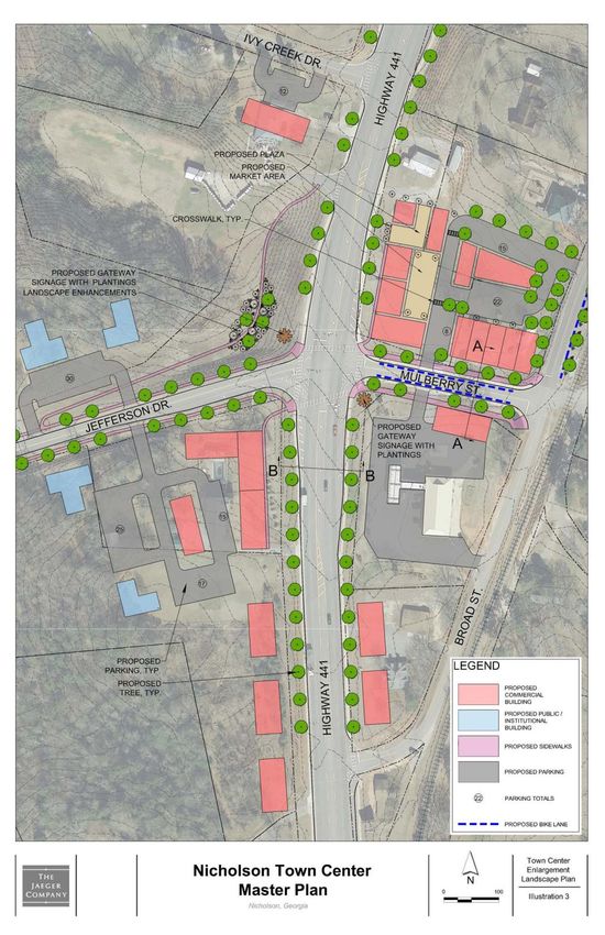
City of Nicholson, GA, Comprehensive Plan, 2016-2035

PLANNING REQUIREMENTS

This Comprehensive Plan must comply with substantive and procedural requirements specified
in the Rules of the Georgia Department of Community Affairs (“DCA”), O.C.G.A. Chapter 110-
12-1, Minimum Standards and Procedures for Local Comprehensive Planning, effective March
1, 2014. The following elements of the comprehensive plan are required and are included in this
comprehensive plan for the City of Nicholson: community goals, needs and opportunities, land
use, and a community work program. Procedurally, the comprehensive plan must be prepared
with input from an appointed steering committee which must include the active participation of
the city’s elected officials.

ABOUT NICHOLSON

Nicholson was initially established as the town of “Cooper,” named after the owner of a large
farm in the area. Cooper was named “Nicholson” in 1882. The city was incorporated in 1907.
Nicholson is located within Jackson County northeast of the metropolitan Atlanta Region, just
northwest of the Athens-Clarke County metropolitan region, and east of the Gainesville
urbanized area. U.S. Highway 441, which runs through the center of the city in a north-south
direction, links Nicholson to Athens and Commerce as well as the north Georgia Mountains to
the north. Nicholson is about 10 miles from the county seat of Jefferson. A railroad track
generally parallels U.S. Highway 441.

The city limits were initially laid out in a rectangular shape, along old Highway 441. Nicholson
annexed approximately 491 acres of land between 2003 and 2008, according to annexation
records of the Georgia Department of Community Affairs. As of today, it consists of more than
2,500 acres in area (about 3.9 square miles). Nicholson is a relatively small and rural city, with a
population of less than 2,000 persons. Jackson County is still mostly rural but rapidly
suburbanizing. Nicholson and southeast Jackson County are witnessing growth pressures from
the Athens-Clarke County region to the southeast.

                                                   6
City of Nicholson, GA, Comprehensive Plan, 2016-2035

                                         CHAPTER 2
                                  NEEDS AND OPPORTUNITIES

As specified in the local planning requirements of state administrative rules, this chapter
analyzes strengths, weaknesses, opportunities, and threats (SWOT) and presents the locally
agreed upon needs and opportunities the city intends to address in this comprehensive plan.
This chapter is based on analysis and evaluation by the city’s planning consultant and reviewed
and revised by the city’s appointed comprehensive plan steering committee. Each of the needs
or opportunities that the city identifies as high priority must (per state administrative rules) be
followed up with corresponding implementation measures in the community work program of
this comprehensive plan.

HOUSING AND POPULATION

A major strength of the city is its location, about a dozen miles from Athens with easy access to
that region via U.S. Highway 441. Another strength is the city’s rural character adjacent to
growing regions. Nicholson is a desirable location for residence, within commuting distance to
Commerce, Jefferson, Braselton, and Athens. Yet another strength is the affordability of the
city’s housing stock; as one indicator, the 2014 estimates of housing units from the American
Community Survey reveal that a sizable majority (58%) of homes in Nicholson are
manufactured homes, which tend to be more affordable for moderate-income households than
stick-built homes.

Despite its strengths in terms of location and rural character, there are signs of continued
housing market weaknesses in Nicholson. Estimates from the 2014 American Community
Survey indicate that no new housing units were constructed in the city since 2010. Nicholson
was home to about 654 housing units in 2010. American Community Survey estimates (subject
to significant margins of error) reveal that Nicholson had 651 housing units in 2014. These
numbers reveal a slight net loss in the city’s housing stock but not necessarily a trend.
Nonetheless, a declining housing stock, in terms of quantity, is a potential threat. It is desirable
to avoid a decline in the quantity of housing, since a decline would limit housing choice locally
and hinder the city’s overall population stability.

The lack of new homebuilding in Nicholson can be explained in part by examining the housing
market in Jackson County, which has been slow to recover from the great recession. Census
estimates reveal that the total housing stock in Jackson County increased by less than 200 units
from 2010 to 2015. Further, the excess hyper-platting of residential lots in unincorporated
Jackson County prior to the great recession will severely limit market potential in Nicholson in
the near-term and perhaps for the majority of the 20-year planning horizon, since so many
opportunities are available there for homebuilding.

Nicholson’s housing market is also weakened by limitations associated with a lack of sanitary
sewer service. There is little housing choice in Nicholson. The existing housing stock in
Nicholson is limited to stick-built and manufactured homes on rural-sized lots. This will remain
the case in the near future. Higher-density residential development is just not possible without
sanitary sewer service.

The 2014 American Community Survey estimates indicate that a sizable majority (58%) of
homes in Nicholson are manufactured homes. Although Nicholson does not collect an ad
valorem property tax, manufactured homes add little or nothing to the local property tax base
(manufactured homes are generally treated for tax purposes as personal property unless placed

                                                   7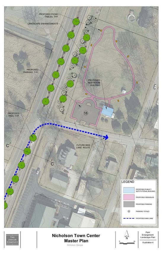
City of Nicholson, GA, Comprehensive Plan, 2016-2035

on a permanent foundation and owner occupied, in which case they are taxable as real
property).

A trend toward higher housing vacancy rates is another sign of Nicholson’s housing market
weakness and could even become a threat to neighborhood stability. A large number of vacant
homes may be considered a threat if they remain vacant and deteriorate in place without
maintenance. In 2010, approximately 10% of the city’s housing stock was vacant. As of 2014
American Community Survey estimates indicate that approximately 22% of all homes in
Nicholson were vacant. If vacancy rates stay that high or increase in concentrated areas,
neighborhood conditions could be adversely affected by absentee property owners and/or a lack
of property and housing unit maintenance.

Since housing is a private market function, there is little if anything the city can do to affect local
housing vacancy rates. As a small rural municipality, Nicholson is not expected to be active in
influencing the local housing market or providing incentives or support for housing programs.
For example, the city has no staff to monitor local housing conditions or pursue community
development grants for housing and neighborhoods. The city has been active in addressing
declining neighborhood conditions along Pace Drive (identified in the previous comprehensive
plan as an area requiring special attention), via demolition of substandard units. The city has
also established a more thorough and rigorous code inspection program as of 2016, which will
help to avoid blighting or substandard housing conditions and stabilize property maintenance
conditions.

The ratio of stick-built homes to manufactured homes is, and can continue to be, influenced by
local zoning regulations. The city’s zoning ordinance and official zoning map provide
opportunities for manufacturing housing in rural residential and agricultural zoning districts,
which together are larger in land area than the suburban residential zoning district which does
not permit manufactured homes. If city leaders are concerned about an over-reliance on
manufactured homes as the predominant housing stock, changes to zoning regulations and the
official zoning map might be made, although such changes are unlikely to make an appreciable
difference in the ratio of stick-built to manufactured homes. Such changes also could undercut
the very strength of the local housing market, which is amenable to manufactured homes.

The city’s current estimated population in 2015 (1,718 persons) is slightly higher than in 2010
(1,656 persons). The projections in the 2010 comprehensive plan were for 3,000+ people by
2030, which is no longer considered realistic given available land, infrastructure availability, and
housing market trends in and affecting the city. The city’s population projections (which were
based largely on projections in the Countywide Roadways Plan, 2008-2018, have been
moderated substantially as a result, showing basically stable population in the short-term and
modest increases in the latter half of the planning horizon. No annexation is assumed by these
projections, but they do assume that the city will establish some limited sanitary sewer service in
part of town during the latter half of the planning horizon.

                                        Table 2.1
            Population and Housing Unit Forecasts, 2010-2030, City of Nicholson

 Projection                                         2015       2020       2025       2030       2035
 City of Nicholson Population                       1,718      1,790      1,820      2,000      2,200
 City of Nicholson Housing Units                     650        650        670        700        750
Source: Jerry Weitz & Associates, Inc. 2016, based on Census Bureau and American Community Survey estimates.

                                                     8
City of Nicholson, GA, Comprehensive Plan, 2016-2035

The strongest action that Nicholson can take in terms of addressing concerns about the lack of
housing choice, and potentially declining housing quantity, is to institute sanitary sewer service
to a part of the municipality. Doing so will open up opportunities for diversifying the housing
stock in Nicholson. Such additions to the housing stock with sewer service could include higher-
density single-family detached subdivisions, senior-friendly housing developments, apartments,
condominiums, townhouses, dwellings in mixed-use buildings, and institutional living and care
arrangements.

ECONOMY

Nicholson is mostly an agricultural and rural residential community. Nicholson’s commercial land
use totaled 28 acres in 2016. Nicholson has no land uses classified as industrial. The state’s
quality community objectives with regard to “appropriate business” and “employment options”
were evaluated and embraced in the city’s 2010 community assessment. Nicholson has about
41 acres of public-institutional development, but that includes a school, city hall, and post office
and thus does not account for major institutional employment. Put simply, Nicholson does not
have much of a non-residential base of development to generate significant employment
opportunities.

The lack of employment opportunities within the city limits is a significant concern to city
officials. Without sanitary sewer service, recruitment of manufacturing establishments to
Nicholson is unlikely to succeed. Nicholson has no finance and insurance establishments in
town, either. It would be beneficial to get a local or regional branch bank to locate in Nicholson.
The presence of one bank alone is likely to provide some local lending opportunities and may
spearhead some additional non-residential development (2010 community assessment).
Nicholson appears to be underserved by retail trade and food services establishments.

Nonresidential development can also be stymied by local land use regulations. As noted in the
community assessment, the first zoning ordinance adopted by the city in 2008 provided very
little if any capacity for new commercial development. That problem was remedied by the city
with a comprehensive revision of its zoning ordinance and official zoning map in 2010, which
added land zoned highway business and commercial town center.

As recognized in the 2010 community assessment (prepared as part of the previous
comprehensive plan), planning for future sanitary sewer service is clearly fundamental to
preparing for growth. There is an opportunity to spark economic development in Nicholson if
sanitary sewer service can be provided in the town center during the planning horizon. The city
has an opportunity to implement its master plan for the town center (adopted in 2014), if sanitary
sewer service can be instituted. Therefore, the most important steps with regard to pursuing
economic development objectives is for the city to institute sanitary sewer service to the town
center and to implement the town center master plan, which has been incorporated into this
comprehensive plan.

NATURAL AND CULTURAL RESOURCES

Nicholson has few environmental conditions that will limit its development potential, and it has
few if any natural resources such as flood plains or river corridors that need to be singled out as
requiring special attention. There are no sites or districts listed on the National Register of
Historic Places in Nicholson, and there are few if any historic resources left in Nicholson that
would warrant additional public regulation or programs (2010 Community Assessment).

                                                   9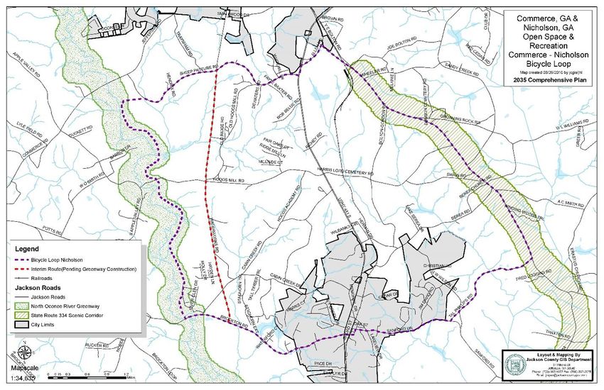
City of Nicholson, GA, Comprehensive Plan, 2016-2035

Nicholson has put into place some significant land use regulations that will help ensure the
environment is protected, but there are still some protection measures that are lacking or which
need updating. Nicholson still needs to adopt regulations implementing the state’s
environmental planning criteria. The eastern half of the city limits of Nicholson lies within the
Sandy Creek small water supply watershed. That watershed provides a supply of public drinking
water for Athens/Clarke County. The city does not have in place any regulations to implement
the environmental planning criteria for small water supply watersheds (included in community
work program).

Nicholson also needs to adopt a floodplain management ordinance to incorporate flood plain
maps prepared in 2010, in order to participate in the National Flood Insurance Program. Areas
of flood hazard are limited in Nicholson to the extreme western edge of the city along SR 335,
along a tributary of the North Oconee River, and along a stream in the southeastern part of
Nicholson. It is important that the city initiate participation in the National Flood Insurance
Program (included in the community work program).

Nicholson is not currently a “local issuing authority” for soil erosion and sedimentation control.
Presently, review of development plans for soil erosion is relegated to the state. Some
consideration might be given to becoming a “local issuing authority” under the state’s soil
erosion and sedimentation control act, or joining an existing local issuing authority for proper
enforcement of land development activities.

COMMUNITY FACILITIES AND SERVICES

 Nicholson has a library, a city hall, a
 community center, a post office, and a fire
 and Emergency Medical Services (EMS)
 station. There is one school (Benton
 Elementary) inside the city limits.
 Nicholson is served by Jackson County’s
 East Jackson Park, which is also within
 the city limits. The city operates public
 cemeteries. Generally, there are no other
 significant community facilities in
 Nicholson. In the recent past, Nicholson
 has considered but decided not to initiate
 its own municipal police force.

                                                          City Cemetery in Nicholson

The City of Nicholson is served by the Nicholson Water Authority with water lines through much
if not all of the current city limits. The Nicholson Water Authority has completed projects to
replace two-inch water pipes in the City with four-inch and six-inch pipes for fire protection and
future growth opportunities. The city’s Fire ISO rating was reduced from 9 to 5 as a result of
these improvements. The city has planned adequately to meet future water distribution needs.

                                                  10
City of Nicholson, GA, Comprehensive Plan, 2016-2035
A lack of sanitary sewer service is the chief weakness with regard to community facilities and
services, as already noted in this needs assessment. Provision of sanitary sewer service is
within the purview of the Nicholson Water Authority. Although the authority should take the lead
in such efforts to provide sanitary sewer service, the provision of sewer is so important that the
city must take on a strong participatory role in sanitary sewer feasibility and development
(included in community work program). The hydrology plan for the Nicholson Town Center is a
first step in determining feasible options for sanitary sewer treatment (see figure).
The 1998 comprehensive plan alluded to evolving service needs in southeast Jackson County.
In particular, it was suggested in the 1998 comprehensive plan that Nicholson and southeast
Jackson County need to be better served by county public health facilities. Later plans of the
city recognized and articulated the need for a municipal and county shared community service
center, and the town center plan suggested a future location.
This comprehensive plan suggests that Nicholson pursue a government service center in
Nicholson. That government service center may include the highest identified priority for future
county government facilities in Nicholson: a health center. Also, over the longer term Nicholson
may want to build a new city hall (identified as a long-range project), and if so, a location
between Broad Street and U.S. Highway 441 at the north end of the town center zoning district
would be an appropriate joint venture (co-location) with a county health service center.
A city-county community services center is included as a long-range project in this plan (see
Table 5-2). Also, acquisition of land for construction of Town Center park (recommended in the
Master Plan) is included as a long-range project in Table 5-2.
11City of Nicholson, GA, Comprehensive Plan, 2016-2035
12City of Nicholson, GA, Comprehensive Plan, 2016-2035
LAND USE AND DEVELOPMENT MANAGEMENT
The city did not have a zoning ordinance to regulate land uses in the city until 2008. The first
zoning ordinance and official zoning map had a number of issues which were corrected with
adoption of a new zoning ordinance and official zoning map in 2010. The city also shortly
thereafter adopted a basic set of subdivision and land development regulations.
With only one administrative employee, the city has historically been challenged to adequately
manage development and administer zoning regulations. Since 2010, the city has had a private
planning consultant assist the city clerk with zoning administration. The city established a
planning commission in 2010 which has also helped improve land use, zoning, and
comprehensive planning functions. Due to leadership by its planning commission, the city
adopted a design review process as an amendment to its zoning ordinance in 2013 and also
adopted design guidelines to improve the function and aesthetics of nonresidential development
in the city.
One of the most pressing needs is for the city to revise its sign ordinance. There are also
additional steps that need to be taken to ensure administration of zoning and development
regulations in a proper, efficient fashion. That includes preparation of development process
summaries and placing administrative forms on the city’s web page.
TRANSPORTATION
Nicholson is well served by a fully improved
U.S. Highway 441, which bisects the city
(runs through the middle of it) in a north-
south direction. The other principal means of
travel into and out of Nicholson is SR 335,
which leads west to the City of Jefferson. SR
335 is not presently overburdened with traffic
but is experiencing increasing traffic
volumes, raising the issue in the countywide
roads planning process whether SR 335 will
need widening in the longer-term future.
U.S. Highway 441 in Nicholson
Although sidewalks exist along both sides of U.S. Highway 441, the highway itself remains a
major barrier to pedestrians even if traffic is relatively light. For Nicholson to grow its town center
in a pedestrian-friendly way, additional, safe pedestrian crossings of U.S. Highway 441 would
be needed at appropriately spaced intervals to unify properties on the west and east sides of
U.S. Highway 441 into a pedestrian-accessible town center. One of the greatest potential needs
is for a pedestrian crossing at Ivy Creek Road’s intersection with U.S. Highway 441. In order to
provide safety and refuge, pedestrians may need refuge islands to cross the 5-lane cross
section of U.S. Highway 441safely and comfortably.
The existing local road network is not as adequate. During the citizen participation process,
citizens expressed some concern that the roadway network in the city was too narrow to
facilitate additional improvement. Road improvements are needed where the travel widths do
not facilitate safe two-way travel, but it is also recognized that some of the narrow city streets
13City of Nicholson, GA, Comprehensive Plan, 2016-2035
cannot be improved without acquisition of additional right of way. Road resurfacing is included in
the community work program.
Also, per public input, the work program
includes an engineering study to evaluate stop
signs and other traffic considerations,
including a traffic management plan for major
events such as the Daisy Festival, which may
include temporary one-way routing.
In response to prior public input on the 2010
Comprehensive Plan, the city has arranged for
the installation of street lights along U.S.
Highway 441 in the city. Nicholson is not
served by public transportation except for
Jackson County’s Section 5311 Rural
Transportation Program. The city has no Lakeview Drive, a local street,
bicycle facilities and a very limited sidewalk looking east from U.S. Highway 441
network.
Nicholson is proposed to be an origin-destination in the broader plan of Jackson County to
provide a bicycle loop route between Nicholson and Commerce. Facilities for bicyclists do not
presently exist in Nicholson, however. One of the most important bicycle access improvements
needed is a crossing of U.S. Highway 441 at SR 335 /Mulberry Street, as well as a designated
bicycle lane or route along SR 335 and Mulberry Street in Nicholson. Other bicycle lane or route
additions are also needed to implement the bicycle route planned over the long-term between
Nicholson and Commerce.
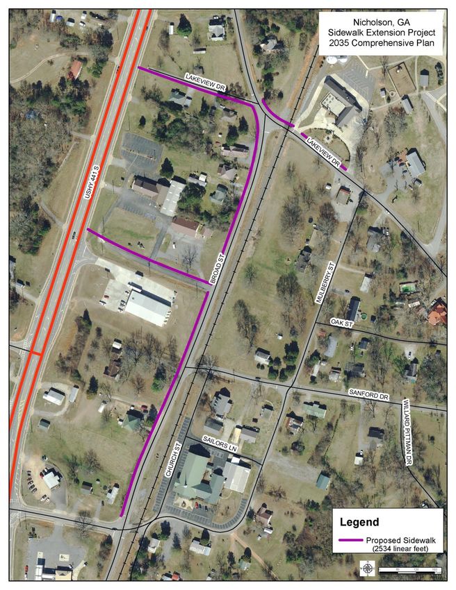
A sidewalk extension program was prepared as part of the town center master plan to improve
pedestrian access and movement in the evolving downtown area. Nicholson should pursue
grants in order to secure funds to construct sidewalk improvements in conjunction with town
center development.
14City of Nicholson, GA, Comprehensive Plan, 2016-2035
Sidewalk Extension Plan for Town Center
15City of Nicholson, GA, Comprehensive Plan, 2016-2035
Long-Range Regional Bicycle Loop Route
The city has been approached by property owners along private roads asking that they become
public. The city needs a measured response to this complicated issue. This is included in the
community work program.
A long-range project was called for in the 2010 comprehensive plan and is retained in this plan:
a regional bike loop route connecting Nicholson to Commerce via SR 334 and the North
Oconee River greenway (also a long-range project). Other long-range transportation projects
recommended in the Town Center Master Plan include improvements to Mulberry Street and
Broad Street. These are included in Table 5-2.
BEAUTIFICATION AND AESTHETICS
As noted elsewhere, Nicholson in 2013 amended it zoning regulations to require design review
for nonresidential developments, and in 2014, it adopted a set of design guidelines for
development. In addition, the town center master plan, also adopted in 2014, addressed
gateway, beautification, and aesthetics issues, including a prototype for gateway improvements
(see figure). A number of properties owned by the Georgia Department of Transportation along
U.S. Highway 441 are now “surplus” and are prime candidates for landscaping, gateway, and
other aesthetic improvements.
The community work program includes an annual outlay for landscaping and beautification
projects. Some of the aggressive landscaping and beautification projects called for in the Town
Center Master Plan are considered long-range and are included in Table 5-2.
16City of Nicholson, GA, Comprehensive Plan, 2016-2035
17City of Nicholson, GA, Comprehensive Plan, 2016-2035
CHAPTER 3
POLICIES
ANNEXATION
1. Annexation and subsequent development should be in compliance with the county’s
comprehensive plan and, to the extent it may be addressed, the city’s comprehensive
plan.
2. An annexation request should not be the result of an applicant seeking relief by the city
due to the filing of a request with Jackson County which was denied by the county.
ENVIRONMENT AND NATURAL RESOURCES
1. Environmental and Resource Protection. Encourage new development to locate in
suitable locations in order to protect natural resources, environmentally sensitive areas,
or valuable historic, archaeological or cultural resources from encroachment.
2. Wetlands – Preservation and Mitigation. Preserve wetlands where they exist, or as a
last resort if they cannot be preserved on-site, mitigate wetland loss by increasing
ecologically equivalent wetlands on other appropriate sites (i.e., wetland mitigation
through wetland banking).
3. Wetlands – Review for Development Impacts. Any proposal for development involving
the alteration of, or an impact on, wetlands should be evaluated according to the
following (based on Ga. DNR Rule 391-3-16-.03):
Whether impacts to an area would adversely affect the public health, safety, welfare,
or the property of others.
Whether the area is unique or significant in the conservation of flora and fauna
including threatened, rare, or endangered species.
Whether alteration or impacts to wetlands will adversely affect the function, including
the flow or quality of water, cause erosion or shoaling, or impact navigation.
Whether impacts or modification by a project would adversely affect fishing or
recreational use of wetlands.
Whether an alteration or impact would be temporary in nature.
Whether the project contains significant State historical and archaeological
resources, defined as “Properties On or Eligible for the National Register of Historic
Places.
Whether alteration of wetlands would have measurable adverse impacts on adjacent
sensitive natural areas.
Where wetlands have been created for mitigation purposes under Section 404 of the
Clean Water Act, such wetlands shall be considered for protection.
4. Wetlands – Uses. Uses of wetlands may include: Timber production and harvesting;
wildlife and fisheries management; wastewater treatment; recreation; natural water
quality treatment or purification; and other uses permitted under Section 404 of the
Clean Water Act. Unacceptable uses may include: receiving areas for toxic or hazardous
waste or other contaminants; and hazardous or sanitary waste landfills.
18City of Nicholson, GA, Comprehensive Plan, 2016-2035
5. Water Supply Watersheds. Maintain in the city zoning ordinance regulations that
implement the Georgia Department of Natural Resources’ Rules for Environmental
Planning Criteria for Water Supply Watersheds (391-3-16-.01, “Criteria for Water Supply
Watersheds”).
6. Floodways and Floodplains. Prohibit development within floodways and restrict or
prohibit development in flood plains. If development within flood plains is allowed, flood
plain storage should not be decreased from its present state. In no event should
development be permitted that inhibits the flow of floodwaters.
7. National Flood Insurance Program. Participate in the National Flood Insurance
Program. Adopt and periodically amend the flood damage prevention/floodplain
management ordinance to comply with changes to ordinances specified by the Federal
Emergency Management Agency.
8. Floodways and Floodplains – Observed But Not Mapped. Extend floodplain
management, flood hazard area prevention, and floodway prohibitions to areas of
flooding which are not officially mapped but are known through additional study or
observation to experience flooding. Maintain and share data on such additional
floodways and floodplains with the public and development applicants.
9. Soils with Severe Limitations. Avoid development using septic tanks in those areas
with severe limitations on septic tank absorption fields.
10. Tree Protection. Promote the protection and preservation of trees and green open
spaces in all new developments. As development occurs along the west side of U.S.
Highway 441 north and south of SR 335, concerted efforts should be made to retain
trees and the forest buffer that currently exists. This is especially important because few
trees exist in other parts of the town center. Natural vegetation on the west side will
provide “edge” and separation to help define the boundary of Town Center.
11. Open Space Conservation.
Conservation. When subdivision or land development involves land designated on
the future land use plan map as conservation, such subdivision or land development
should protect all (or at least the vast majority) of the land designated as
conservation as permanent open space.
Land Development Impacts. If land development within a conservation area is
permitted, it needs to minimize the impact on water quality and the environment.
Acceptable mitigation practices for land development in conservation areas may
include limiting pavement and impervious surfaces, natural buffers, and low impact
development designs which feature naturalized designs for stormwater management.
Annexation. If Nicholson annexes land designated as conservation, it should
provide for the permanent protection of the land designated as conservation by
appropriate means in a manner consistent with county policies for the conservation
character area.
19City of Nicholson, GA, Comprehensive Plan, 2016-2035
Access to Abutting Conservation Lands. Subdivisions and land developments are
strongly encouraged, if not required, to provide pedestrian easements or fee-simple
land dedications to public open spaces and/or publicly designated conservation
lands on all abutting properties.
12. Habitat Protection. Consider habitat information in review of land developments,
including but not limited to the database of the DNR Natural Heritage Program, USFWS
County Listing of Threatened and Endangered Species and the DNR Listing of Locations
of Special Concern Animals, Plants, and Natural Communities.
13. Stormwater Management.
Design man-made lakes and stormwater ponds for maximum habitat value and to be
amenities for the development.
Sites should be designed where possible to drain to the rear or side, where detention
ponds are more appropriately located. Fenced detention ponds in front yards are
strongly discouraged if not prohibited altogether.
When stormwater detention or drainage is placed adjacent to the right-of-way, slopes
should be gentle enough to avoid fencing requirements, and the area should be
attractively landscaped.
New, major residential subdivisions should be required to ensure that adequate
funding is available for maintenance of any on-site stormwater detention facilities.
14. Low Impact Development. Promote low impact development that preserves the
natural topography and existing vegetation of development sites, and utilizes natural
drainage patterns as much as possible.
15. Leadership in Energy and Environmental Design (LEED). Nicholson encourages
LEED certifications for buildings. The Leadership in Energy and Environmental Design
(LEED) Green Building Rating System™, developed by the U.S. Green Building Council
(USGBC), is a voluntary, consensus-based, national standard for developing high
performance, environmentally sustainable buildings and communities. The Rating
System addresses six major areas, which include: Sustainable sites; Water efficiency;
Energy and atmosphere; Materials and resources; Indoor environmental quality; and
Innovation and design process. LEED certification is granted solely by the U.S. Green
Building Council. To earn certification, a building project must meet certain prerequisites
and performance benchmarks (“credits”) within various categories. Projects are awarded
Certified, Silver, Gold, or Platinum certification depending on the number of credits they
achieve.
HOUSING
1. Housing Options. Provide for and encourage new land uses that enhance housing
options in the community. These include an openness to single-wide manufactured
homes, estate-style subdivisions, institutionalized living and care arrangements, and
housing for the disabled.
20City of Nicholson, GA, Comprehensive Plan, 2016-2035
2. Substandard Housing. Eliminate or mitigate substandard or dilapidated housing in the
community.
3. Housing for Persons with Disabilities. Avoid regulations and practices that would
discourage the provision of housing for persons with disabilities.
4. Avoid Regulatory Barriers. In amending zoning and development regulations, the city
should consider the potential impact of such amendments on housing affordability, in
order to possibly avoid creating or sustaining “regulatory barriers.”
5. Nonprofit Housing Organizations. Encourage the creation of, and cooperate with,
community-based housing organizations in the pursuit of affordable workforce housing.
ECONOMIC DEVELOPMENT
1. Economic Development Generally. Expand the economic base and increase
employment opportunities while protecting environmental, historic, and community
character.
2. Appropriate Businesses. The businesses and industries encouraged to develop or
expand in Nicholson should be suitable in terms of job skills required, linkages to other
economic activities in the county or region, impact on the resources of the area, and
future prospects for expansion and creation of higher-skill job opportunities (Quality
Community Objective, Appropriate Business).
3. Business Recruitment. Increase the supply of jobs in the community. Develop support,
and participate with the Jackson County Area Chamber of Commerce in programs for
retention, expansion and creation of businesses that are a good fit for Nicholson’s
economy in terms of job skill requirements and linkages to existing businesses.
4. Range of Jobs Available. A range of job types should be provided in each community
to meet the diverse needs of the local workforce (Quality Community Objective,
Employment Options).
5. Industry and Manufacturing. Nicholson does not have an industrial park, has not set
aside land areas for industry and manufacturing, and presently does not have sanitary
sewer to serve such development. Therefore, industry should be limited, if developed at
all in Nicholson, to the U.S. 441 corridor and should consist of low-impact storage,
warehousing, and cottage-type industrial establishments that are small in nature and
consistent with the city’s small town character.
6. Infrastructure. Provide and maintain sanitary sewer capacity in order to attract new
commercial and service activities along U.S. Highway 441 and in the Town Center.
7. Positive Business Climate. Create and maintain a positive climate for business in the
city.
8. Balanced Regulation. Balance the need to regulate the design and appearance of
commercial and other properties with a positive regulatory environment that is sensitive
to the need for businesses to be competitive in the marketplace.
21City of Nicholson, GA, Comprehensive Plan, 2016-2035
9. Education and Training. Educational and training opportunities should be readily
available in the city to permit residents to improve their job skills, adapt to technological
advances, or to pursue entrepreneurial ambitions (Quality Community Objective,
Educational Opportunities). Increase skill levels of the resident labor force, in order to
attract higher paying employers.
LAND USE – GENERALLY
1. Prevailing Land Use Patterns. Respect and maintain prevailing land use patterns,
unless the future land use plan clearly suggests changes are appropriate.
2. Protect Residences from Incompatible Land Uses and Nuisances. Where
designated residential on the future land use plan map, maintain and preserve quiet,
stable neighborhoods of residences at current densities. Preserve and enhance the
stability of existing residential neighborhoods. Protect residential areas (whether rural,
suburban, or urban) from nuisances (e.g., excessive noise, odor, traffic and lighting) and
from encroachment by incompatible land uses.
3. Preservation of Residential Neighborhoods. The consideration of the preservation of
the integrity of residential neighborhoods shall be considered to carry great weight in all
rezoning decisions.
4. Transitional Properties and their Impacts on Residential Neighbor-hoods. In those
instances in which property proposed for rezoning from residential to nonresidential use
fronts on a major thoroughfare and also adjoins an established residential neighborhood,
the factor of preservation of the residential area shall be considered to carry great weight
in all rezoning decisions.
5. Natural Areas, Open Space and Recreation. New residential development should
preserve the natural amenities of the land through maintenance of conservation areas
and open spaces. When new major residential subdivisions are developed, there should
be a minimum of 20 percent of the total development area set aside for green space,
open space, and active or passive recreational opportunities.
6. Creativity and Flexibility. Encourage creativity in development design and provide for
design flexibility. The city is open to considering land planning and development
concepts that may be new to the city but have been implemented successfully in other
places.
7. Sustainable Development Practices. Communities and individual land developments
which are developed consistent with generally accepted principles of sustainable
development should receive priority consideration over developments relying on
conventional designs and features. Any available incentives should be used to reward
development which meets generally accepted sustainable development principles.
LAND USE – TOWN CENTER
1. Enhance the City of Nicholson’s image as a unique community and retain that image in
attractive and orderly development that preserves existing character of a historic railroad
community.
22City of Nicholson, GA, Comprehensive Plan, 2016-2035
2. Cultivate distinctiveness so that the City of Nicholson remains unique among Jackson
County and communities in the northeast Georgia region.
3. Encourage the creation and development of a downtown in central Nicholson which is a
compact, vibrant, mixed use, pedestrian-friendly center of the community.
4. Promote high quality nonresidential development. Establish and maintain architectural
and site design standards as appropriate in nonresidential areas to encourage increased
quality of site development, architectural appearance, and building materials.
5. Require new development to respect the scale and character of nearby structures and
minimize or mitigate abrupt and excessive differences.
6. Ensure that development in the downtown area has a human/pedestrian scale and a
building scale appropriate for a small town.
7. Provide guidelines and/or regulations to ensure the desired character of downtown is
met.
LAND USE – HIGHWAY BUSINESS
1. Improve community identity. Create civic gateways to the City that produce a sense of
arrival. These entryways should incorporate streetscape elements, signage, and
landscaping that enhance the image and function of the City. Encourage the provision of
public green spaces in gateway areas as private development occurs. Support and
encourage private and public efforts to install signage and unique gateway features that
identify the city, particularly its focal point(s).
2. Promote high quality nonresidential development. Establish and maintain architectural
and site design standards as appropriate in nonresidential areas to encourage increased
quality of site development, architectural appearance, and building materials.
3. Initiate community-based streetscape beautification partnerships. Encourage the
greening of Nicholson’s railroad right of way and U.S. Highway 441 corridor through the
planting and maintenance of street yards and the provision of street trees along major
corridors.
4. Avoid unattractive and inefficient strip development along U.S. Highway 441. Regulate
and promote commercial development with designs, landscaping, lighting, signage, and
scale that add value to the community, consistent with regulations proposed by Jackson
County for the U.S. Highway 441 corridor. Discourage patterns of “strip” commercial
development. Encourage building designs which do locate all of the off-street parking
provided on the commercial lot between the road and the building.
TRANSPORTATION
1. Local Street Improvements. Subject to budget limitations, improve existing city streets
by widening substandard roads (where sufficient right of way exists or can be acquired),
improving intersections where they pose traffic safety problems, and installing street
lighting.
23City of Nicholson, GA, Comprehensive Plan, 2016-2035
2. Access Management. Adopt adequate access management standards to control the
connections and access points of driveways and roads to other roadways.
3. Inter-parcel Access. Minimize unnecessary vehicular trips on roadways by
implementing techniques such as requiring non-residential uses to provide cross-access
(inter-parcel) easements during the site plan review and approval process to ensure that
drivers can directly access abutting non-residential uses without having to use the
abutting road or street.
4. Traffic Calming. Consider future needs for traffic calming (raised speed humps, raised
tables, etc.) to slow speeding and/or discourage cut-through traffic.
5. Sidewalk Improvements. Build new sidewalks with priority going to the town center of
Nicholson, in support of downtown place-making.
6. Regional Bicycle Loop. One or more local roads from East Jackson Park connecting to
State Route 334 should be improved with a bike lane or multi-use trail/path.
7. Railroad and Road Grade
Separation. Maintain safe
railroad crossings for drivers,
bicyclists, and pedestrians by
installing gates, lights, and
warning signage.
INTERGOVERNMENTAL COORDINATION
1. Regional Cooperation. Regional cooperation should be encouraged in setting priorities,
identifying shared needs, and finding collaborative solutions, particularly where it is
critical to success of a venture, such as protection of shared natural resources (Quality
Community Objective, Regional Cooperation).
2. Regional Solutions. Regional solutions to needs shared by more than one local
jurisdiction are preferable to separate local approaches, particularly where this will result
in greater efficiency and less cost to the taxpayer (Quality Community Objective,
Regional Solutions).
3. Support for Regional Policies. Coordinate local policies and regulations to support
regional policies. Ensure that goals and implementation programs of the city’s
comprehensive plan are consistent with adopted coordination mechanisms and
consistent with applicable regional and state programs.
24City of Nicholson, GA, Comprehensive Plan, 2016-2035
4. Consultation. Consult other public entities in the area when making decisions that are
likely to impact them.
5. Resource Sharing. Seek and pursue opportunities to share services and facilities with
Jackson County and other municipalities, when mutually beneficial.
6. Conflict Resolution. Resolve conflicts with other local governments through established
mediation processes or other informal or formal means.
25City of Nicholson, GA, Comprehensive Plan, 2016-2035
CHAPTER 4
LAND USE
Because the City of Nicholson has adopted a zoning ordinance and official zoning map, a land
use element is required per state administrative rules for local comprehensive planning. When
Nicholson prepared its comprehensive plan “community agenda” in 2010, the state’s
requirements for local comprehensive plans included a future development map showing
character areas and a narrative description of character areas. Under those rules, a future land
use plan was optional. Nicholson’s previous (2010) plan included both a future development
map of character areas and a future land use plan map. The latest state administrative rules
(effective May 1, 2014) for local comprehensive planning leave it to the local government to
decide whether it should incorporate the character area approach, or a future land use planning
approach, or both, in its comprehensive plan.
While there is some merit in retaining both a character area approach and future land use plan,
this comprehensive plan includes only a future land use plan map and thus repeals the
character area approach utilized in the 2010 community agenda. One of the reasons for that
choice is that there is substantial overlap and similarity between the two approaches, and
retaining two approaches can lead to unintended conflicts and may also lead to confusion by
those who read the plan. It is also believed that the future land use plan is the stronger basis for
supporting the city’s zoning ordinance and official zoning map.
LAND USE CLASSIFICATION
The existing land use and future land use plan maps utilize land use categories described in the
following paragraphs.
Vacant/Undeveloped
This category includes lands that have not been improved with structures or buildings and which
cannot be classified as agricultural or forestry. This category is used only on the existing land
use map. It is not used on the future land use plan map, because each parcel in the city should
have some recommended future use.
Park/Recreation/Conservation
This category includes lands dedicated to
both active and passive recreational uses.
These lands may be either publicly or
privately owned, and they may include
playgrounds, public parks, nature
preserves, wildlife management areas,
forest preserves, golf courses, recreation
centers, or similar uses. In Nicholson,
these include the East Jackson Park and,
on the future land use plan map, flood
plains in the city.
East Jackson Park
26City of Nicholson, GA, Comprehensive Plan, 2016-2035
Agricultural/Forestry
These areas consist of active farms, pasture
lands and large, undeveloped open spaces.
Many of these properties are within the
county’s preferential tax assessment (current
use assessment) program for farmland
and/or timber. Residential uses exist
agricultural/forestry areas, but they are
typically farm-related.
An agricultural scene
south of Sanford Drive
Residential Subcategories
Nicholson’s land use maps divide residential land uses into three categories: conventionally
constructed (stick/site built) detached, single-family homes (dubbed suburban residential),
manufactured homes (referred to as rural residential), and multi-family areas. The treatment of
manufactured homes differently from site-built homes in the land use inventory and on the future
land use plan reflects community preferences that manufactured homes should not be permitted
in all residential zoning districts, as well as the city’s current zoning map. The multi-family
designation reflects existing duplexes and in one case a small apartment building; expansion of
multi-family residential is not contemplated in the short term in the future land use plan, given
the current lack of sanitary sewer service.
Rural Residential
Rural residential areas are primarily platted
and developed for detached, single-family
(conventional/site built) and manufactured
homes on larger lots (i.e., more than one
acre), mostly on the periphery of the
Nicholson city limits. There is a large
subdivision consisting mostly of
manufactured homes, north of Sanford
Road, which is designated as large lot-rural
residential. Another significant
concentration is located west of the town Manufactured housing is common
center, north and south of Jefferson Road in rural residential areas of Nicholson.
(SR 335).
Large lot-rural residential areas do not require infrastructure improvement or additional public
investment, nor are subarea plans necessary. The primary implementation mechanism will be
the city’s zoning ordinance and subdivision and land development regulations.
27City of Nicholson, GA, Comprehensive Plan, 2016-2035
Suburban Residential
These areas are mostly located close to U.S.
Highway 441 and are, for the most part,
geographically close enough to the Town
Center area to promote walking. Dwellings
are limited to detached, single-family
(excludes manufactured homes). Lots are
usually smaller (generally less than one acre)
than that found in rural residential areas.
Some of the road patterns are curvilinear with
cul-de-sacs, while others are more linear,
with lots fronting on existing roads and
highways.
Public/Institutional
This category includes federal, state, and local government uses, and a wide variety of
institutional land uses. Government uses include county-owned facilities, fire stations, post
offices, and schools. Private institutional uses include schools, colleges, churches, cemeteries,
and private non-profit meeting halls, among others.
Commercial (Town Center and Highway Business)
This category applies to lands dedicated
to non-industrial business uses,
including retail sales, offices, services
and entertainment facilities. It is
implemented with the Town Center and
Highway Business zoning districts. The
master plan for Nicholson’s Town Center
began with a delineation of the Town
Center character area (about 75 acres),
as established in the Nicholson 2010
comprehensive plan. That geography is
the same as the Town Center (TC)
zoning district boundary, as established Desired Scale and Character
in the City of Nicholson Zoning Nicholson’s Town Center
Ordinance and on the Official Zoning
Map. It includes some 41 parcels.
Nicholson does not have any existing development that resembles a “Main Street” design (i.e.,
pedestrian-oriented development including shop-front buildings built close to the right of way).
In short, Nicholson needs to create a “place” within the town center that replicates or resembles
one or more downtown commercial blocks in the “Main Street” style of development. Mulberry
Street between US Highway 441 and Broad Street is chosen as the best potential for main
street-style development. Developing a block of Main Street-style development north of
Mulberry Street would require the redevelopment of properties and land uses as well as lot
combinations or property line reconfigurations.
28You can also read