City Center Small Area Plan - DRAFT - June 7, 2021
←
→
Page content transcription
If your browser does not render page correctly, please read the page content below
R I CH M O N D, VI RG I N IA

City Center Small Area Plan

                               DRAFT - June 7, 2021
Main Plaza                                             Protected Bike Lanes
                                                                                                        (N. 6th/E. Leigh)

                       Subterranean
                         Parking                                  Linear Park

                                                                                Mixed-Use
                                                                                Residential              Outdoor Dining
               Blues Armory

                                  Hotel &                                                        Biotech &
                               Entertainment                                                   Life Sciences

                                                                         Municipal

                                                                                                               Fire Station

                                      Bus Rapid Transit       John Marshall House
                                                                                              High School

Figure 1 // Executive Summary of City Center with Development Clusters

2   |   City Center Small Area Plan                                  DRAFT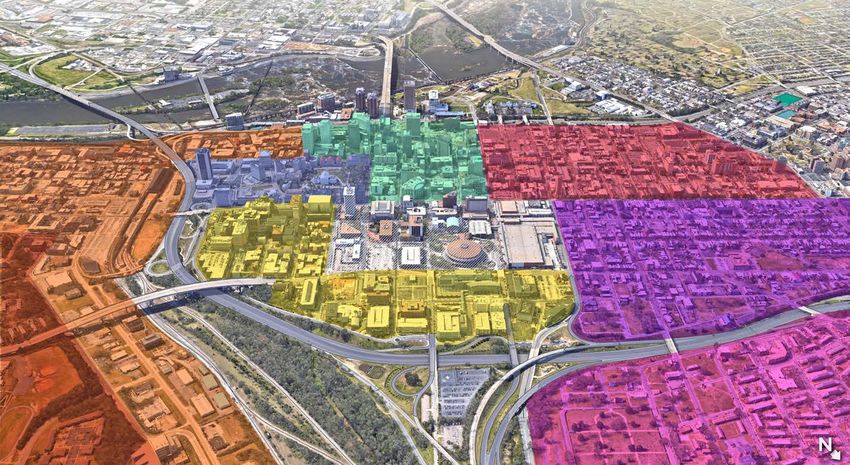
Table of Contents
 Project Scope  .  .  .  .  .  .  .  .  .  .  .  .  .  .  .  .  .  .  .  .  .  .  .  .  .  .  .  .  .  .  .  .  .  .  .  .  .  .  .  .  .  .  .  .  .  .  .  .  .  . 4
 History  .  .  .  .  .  .  .  .  .  .  .  .  .  .  .  .  .  .  .  .  .  .  .  .  .  .  .  .  .  .  .  .  .  .  .  .  .  .  .  .  .  .  .  .  .  .  .  .  .  .  .  .  .  .  . 10
 Existing Conditions .  .  .  .  .  .  .  .  .  .  .  .  .  .  .  .  .  .  .  .  .  .  .  .  .  .  .  .  .  .  .  .  .  .  .  .  .  .  .  .  .  .  .  .  .  . 17
 Existing Plans .  .  .  .  .  .  .  .  .  .  .  .  .  .  .  .  .  .  .  .  .  .  .  .  .  .  .  .  .  .  .  .  .  .  .  .  .  .  .  .  .  .  .  .  .  .  .  .  .  . 23
 Vision and Guiding Principles .  .  .  .  .  .  .  .  .  .  .  .  .  .  .  .  .  .  .  .  .  .  .  .  .  .  .  .  .  .  .  .  .  .  .  . 25
 Plan Overview .  .  .  .  .  .  .  .  .  .  .  .  .  .  .  .  .  .  .  .  .  .  .  .  .  .  .  .  .  .  .  .  .  .  .  .  .  .  .  .  .  .  .  .  .  .  .  .  . 26
 High-Quality Places  .  .  .  .  .  .  .  .  .  .  .  .  .  .  .  .  .  .  .  .  .  .  .  .  .  .  .  .  .  .  .  .  .  .  .  .  .  .  .  .  .  .  .  . 28
 Equitable Transportation  .  .  .  .  .  .  .  .  .  .  .  .  .  .  .  .  .  .  .  .  .  .  .  .  .  .  .  .  .  .  .  .  .  .  .  .  .  .  . 36
 Diverse Economy  .  .  .  .  .  .  .  .  .  .  .  .  .  .  .  .  .  .  .  .  .  .  .  .  .  .  .  .  .  .  .  .  .  .  .  .  .  .  .  .  .  .  .  .  .  . 42
 Inclusive Housing  .  .  .  .  .  .  .  .  .  .  .  .  .  .  .  .  .  .  .  .  .  .  .  .  .  .  .  .  .  .  .  .  .  .  .  .  .  .  .  .  .  .  .  .  .  . 44
 Thriving Environment .  .  .  .  .  .  .  .  .  .  .  .  .  .  .  .  .  .  .  .  .  .  .  .  .  .  .  .  .  .  .  .  .  .  .  .  .  .  .  .  .  .  . 46
 Phasing .  .  .  .  .  .  .  .  .  .  .  .  .  .  .  .  .  .  .  .  .  .  .  .  .  .  .  .  .  .  .  .  .  .  .  .  .  .  .  .  .  .  .  .  .  .  .  .  .  .  .  .  .  .  . 48
 Equitable Development Benefits .  .  .  .  .  .  .  .  .  .  .  .  .  .  .  .  .  .  .  .  .  .  .  .  .  .  .  .  .  .  .  .  . 50

                                                                                                                                                    DRAFT                              |   3
Project Scope

Purpose                                                                 Study Area
The City Center Small Area Plan outlines a strategy for                 City Center is the name of study area, which is generally the area
redeveloping vacant and under-utilized parcels in Downtown              from E. Franklin Street to E. Leigh Street and from N. 10th to N.
Richmond, which are predominantly City-owned. The Plan                  5th Streets in Downtown Richmond. The City Center area is part
describes the vision, guiding principles, and strategies for the City   of Downtown Richmond, Virginia and bounded by VCU Health/
Center area in order to create a more equitable, sustainable, and       VA Bio+Tech Park, the State Capitol, Monroe Ward, and Jackson
beautiful Downtown in alignment with Richmond 300: A Guide for          Ward, as shown in Figure 2. The focus of the City Center planning
Growth and the Pulse Corridor Plan.                                     effort is on the City and RRHA properties that are vacant and/or
The Dept. of Planning and Development Review (PDR) created              underutilized in the City Center area, approximately 26.2 acres in
the City Center Plan in response to City Council Resolution 2020-       total as shown in Figure 3 and Table 1.
R009, with the following objectives:
– Engage the Richmond community to identify the key elements
   that must be located in the primary study area and that shall be
   included in a future request for offers (RFO).
– Set the stage for potential developers to feel excited about
  responding to another RFO by gaining general public
  consensus and thereby minimizing developer risk.
– Guide the redevelopment of Downtown to establish a mixed-
  use destination that drives activity outside of typical business
  hours, provides for regional entertainment attractions, and
  adds to the Downtown tax base
– Leverage adjacencies by connecting with the Convention
  Center, VCU Health, and the VA Bio+Tech Park.
– Build strong connections with adjacent neighborhoods
  including Jackson Ward, Monroe Ward, Gilpin, and Shockoe
  Bottom.
– Incorporate the City Center Small Area Plan into the Richmond
  300: A Guide for Growth master plan document.

4   |   City Center Small Area Plan                                     DRAFT
Gilpin
                                                     Court

                                        Jackson
                                         Ward

                                                             VCU Health/
                                                           VA Bio+Tech Park
                                      Monroe        City
                                       Ward        Center

                                               Downtown
                                                           State
                                                          Capitol

                                                                    Shockoe

                                           James River

Figure 2 // City Center Context Map

                                                   DRAFT                      Project Scope   |   5
1        2          3   4

                                           5        6                7       8
                                               14
                                                      9                      11
                                                               10

                                      12

                                                 13A
                                                13B
Figure 3 // Selected City- and RRHA-Owned Parcels in City Center

6   |   City Center Small Area Plan                                 DRAFT
Table 1 // City- and RRHA-Owned Parcels in City Center

                                                                         Parcel       Surplus    Condition   Maintenance
 Label Parcel Name                         Ownership/Status             Acreage      Property1    Rating2       Cost3
 1        Coliseum                         COR/Vacant                       7.4          x         Poor        Unknown

 2        Coliseum Parking Deck            COR/In Use                       1.9                    Good         $1.3M

 3        9th/Clay Surface Parking Lot     COR/In Use                        2.1         x          Fair         N/A
                                           COR/Vacant - In
 4        Public Safety Building                                            3.0          x        Critical     $20.97M
                                           redevelopment
 5        5th/Marshall Parking Garage      COR/In Use                       1.6                    Good         $1.5M

 6        Coliseum Public Open Space       RRHA/In Use                      1.0                    Poor          N/A

 7        John Marshall Courts Building    COR/In Use                       1.5                    Poor         $18.7M

 8        Social Services Building         COR/In Use                       1.6                    Poor         $4.5M

 9        6th/Marshall Parking Garage      COR/In Use                       0.8          x        Critical       $7M

 10       Theater Row Building             COR/In Use                       0.4          x         Poor         $11.2M

 11       City Hall                        COR/In Use                       1.8          x         Poor        $50.5M
          4th/Broad Surface Parking
 12                                        COR/In Use                        1.1                   Good          N/A
          Lot
          6th/Grace Surface Parking
 13A                                       COR/In Use                       1.0          x         Good          N/A
          Lot
 13B      6th/Franklin Parking Garage      COR/Vacant                       0.5                   Critical     Unknown

 14       Blues Armory Building            RRHA/Vacant                      0.5                    Poor        Unknown

1: Properties surplussed by City Council via Res. No. 2021-R024 on April 26, 2021.
2: Condition rating provided by Department of Public Works.
3: Cost of immediate maintenance provided by Department of Public Works.

                                                                        DRAFT                                    Project Scope   |   7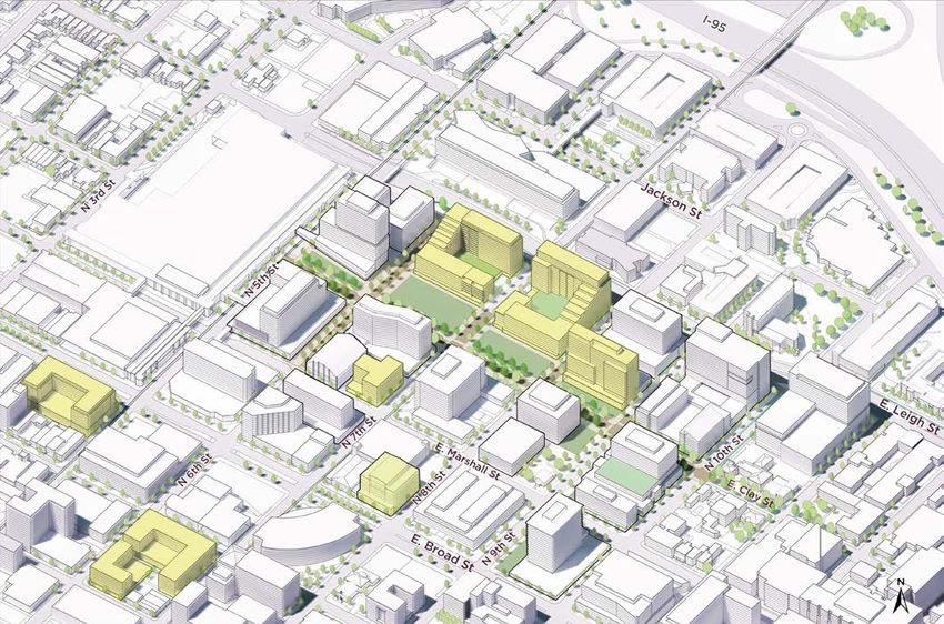
Process
PDR developed the Small Area Plan over a 12-month period that          Phase 3: Stakeholder Interviews
included internal meetings with City staff and leadership, two         From September to November 2020, PDR conducted over 10
public workshops, two public surveys, and several focus group          group interviews with property owners, non-profit organizations,
interviews. At the beginning of the plan development process,          community groups, elected officials, City staff, and other
the idea of including a new or renovated arena was part of the         stakeholders with interest in the City Center area. During those
development program. However, in December 2020, Henrico                interviews, PDR heard that a lot of residential units need to be
County announced that they are going to build an arena-anchored        added to the area to support businesses and that the housing
project; therefore, the City removed the arena concept from the        should be at various price levels and provide rental and ownership
City Center program.                                                   options. Interviewees stated that flexible public open space and
                                                                       strong connections to adjacent neighborhoods are essential.
Phase 1: Priorities and Preferences
During a virtual workshop in June 2020, the City shared a series of    Phase 4: Draft Plan
examples of revitalized downtowns with and without arenas. The         From December 2020 to May 2021, City staff developed the
survey results showed that the community generally supported           draft City Center Small Area Plan and released the plan for public
a set of baseline elements (open space, office, mixed-income           review and comment in May 2021.
residential, multi-modal transportation, and gridded street
network), neighborhood amenities (restaurants, cafes, grocery
store, retail, and services), and community benefits (retail/office
for local businesses, public open space, and equity-ownership by
minorities). The survey results also showed general support for an
arena, strong support for a movie theater, and little support for a
resort casino in the area.

Phase 2: Framework Alternatives
During a second virtual workshop and survey in July 2020, the
City shared 3 framework alternatives that located the arena
and public open space in various configurations and included
recommendations for relocating City functions. The survey results
and conversation during the workshop confirmed strong support
for a mixed-use development and open space. Other elements
that continued to need further discussion included the relocation
of City government uses, the bus transfer facility, and the arena.

8   |   City Center Small Area Plan                                   DRAFT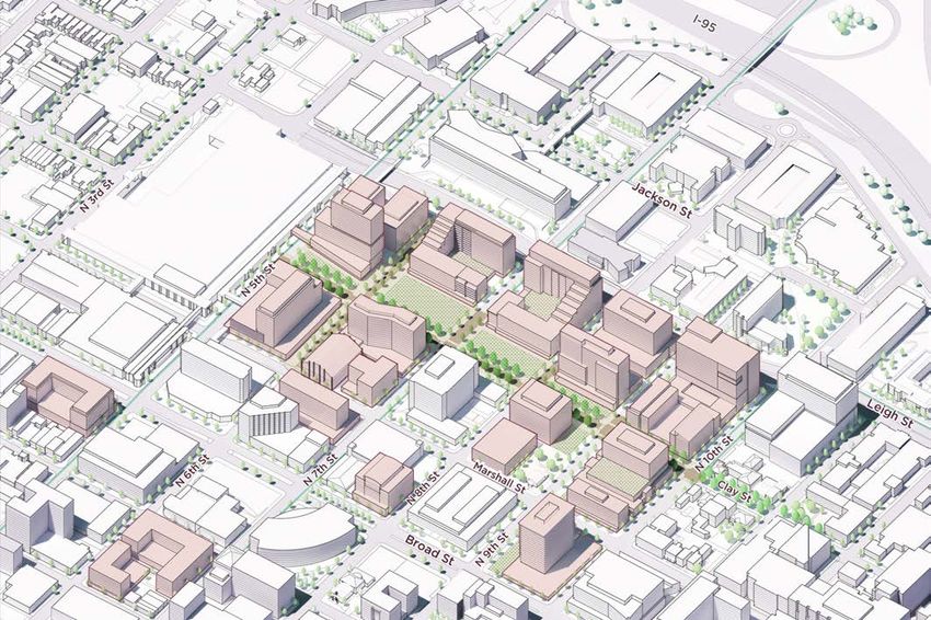
Plan Adoption
            Community Meeting 1                                                          Draft Framework          City Planning Commission
            Preference & Priorities              Stakeholder Focus Groups           Regrouping and moving         and City Council Review &
           (850+ surveys received)                     and Interviews                        forward                       Approval

  June               June 15,         July 14,         Oct./Nov.           Dec.              Jan.             Summer            Fall       Winter
  2020                2020             2020             2020               2020              2021              2021             2021     2021/2022

Initiated Coliseum               Community Meeting 2                    Henrico County                     Draft Plan Release          Implementation
Framework Plan                  Framework Options (>250           announces new arena and                                                 Issue RFOs
                                   surveys received)               mixed-use development

                                                                        DRAFT                                                          Project Scope   |   9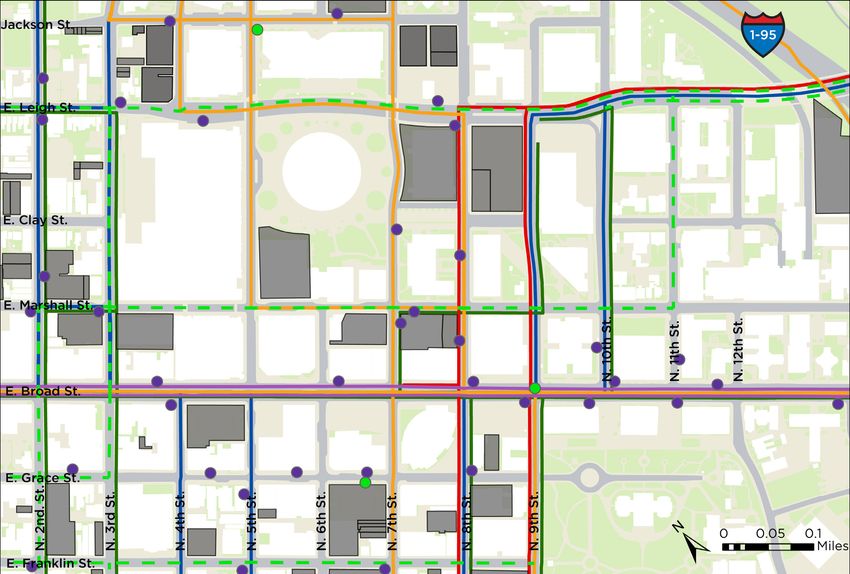
History

Today City Center is completely unrecognizable from its land use
and urban form 100 years ago (Figure 4). Annexed by the City in
the late 18th and early 19th century, the area blossomed due to
its proximity to important buildings like the State Capitol. Broad
Street soon became the City’s most critical commercial center –
especially after the burning of Main Street during the Civil War
and as it developed into the central corridor for the streetcar
system implemented in the late 1880s.

Post-Reconstruction Era, “Jackson Ward” was created as a
political boundary meant to neutralize the new voting power
of the recently-emancipated Blacks. Jackson Ward and its
surrounding areas, over the next few decades, became a thriving
center for Black businesses and entertainment due to events like
the establishment of Maggie Walker’s Consolidated Bank & Trust
and the opening of the Hippodrome Theater. As segregation
and Jim Crow policies expanded, Broad Street became an
entertainment hub for white Richmonders, especially from N. 7th
to N. 9th Streets – coined “Theater Row.” Department stores,
notably Thalheimer’s and Miller & Rhoads, were the cornerstone of
Downtown retail throughout the 20th Century.

As the city’s development expanded further from the original
Downtown areas, white residents moving to the periphery, known
as “white flight,” became the norm. From the turn of the century
until the 1950s, City Center’s racial composition shifted from
majority-white to majority-black. Nevertheless, the development
of the City’s first Master Plan, the creation of all-Black public     Figure 4 // 1924 Block Layout and 1955 Site Photographs
housing, and the construction of the Richmond-Petersburg              Source: 1924 Sanborn Insurance Maps (Library of Virginia); The Valentine Museum

10   |   City Center Small Area Plan                                 DRAFT
Figure 5 // Year of Construction for Existing Buildings

Turnpike (now I-95) all had a hand in displacing thousands of Black residents and destroying their homes within and adjacent to
City Center. Demand for parking in Downtown increased with the rise of the automobile and continued white flight to Henrico and
Chesterfield Counties; many buildings, such as the 6th Street Market and John Marshall High School’s track field, as well as homes and
businesses, were converted into parking garages or demolished and turned into surface parking lots to serve the Downtown commuters.

The growing pace of white flight to the counties had increasingly negative economic impacts for Downtown and the city as a whole. As
Henrico and Chesterfield’s populations boomed, politicians and planners in Richmond attempted strategies to regain prominence and
population, such as the 1970 Chesterfield annexation, the building of the Coliseum in 1971, a new 6th Street Marketplace in 1985, and the
Convention Center in 1986 (Figure 5). Ultimately, Downtown Richmond suffered in the late decades of the 20th Century and into the
2000s. Over the past century, communities, homes, and residents were displaced and replaced with large, non-residential buildings and
a City Center that would only be inhabited from “9 to 5.”

                                                                DRAFT                                                         History   |   11
Major Downtown Richmond Milestones 1788
John Marshall House is built (N. 9th and
E. Marshall). Marshall lives there until
his death in 1835. Today, it’s the last
remaining structure in Downtown built in
the 18th century besides the Capitol.
1792
The Virginia
1782 Capitol building is
completed.
Richmond is
incorporated
as a city with a
population of 1,800
– half of whom are
enslaved people or
1793 1810 free Africans.
1780
1780 The state capitol
1737 1769
is moved from
Richmond is founded 1810 Williamsburg to
and the city is platted by Richmond. 1793
Major William Mayo for 1742
William Byrd II. The streets Much of present-
The area just
and blocks run parallel 1780 North of the
day Jackson Ward 1810
to the James River and and Gilpin Court are
Capitol is Richmond
encompass an area of only annexed, generally
annexed. annexes a
0.23 square miles. Monroe to N. 9th
above E. Broad. little under 1
square mile
After the success from Henrico,
1742 1769 of the 17th Street including much
Marketplace, the of present-day
Areas west of Downtown.
King George II City unsuccessfully
the original town
grants a charter to attempts to
boundaries are
William Byrd II to establish a second
annexed, going as
establish Richmond market, Shockoe
far west as today’s
as a town. Market Hall, at E.
1st Street.
Broad and 12th.
1740
1760
1790
1800
1780
1750
1730
1770
1810
12 | City Center Small Area Plan DRAFT1865
Much of the Main Street
1834 1854 commercial corridor is
The Richmond, Southgate Farm is burned in a fire set by
Fredericksburg & Potomac subdivided and dozens Confederate Troops
Railroad becomes the first 1844 of lots are sold between evacuating the City at
railroad to enter the City with N. 3rd Street and N. the end of the Civil War.
a station located at N. 8th and The Medical Consequently, the Broad
Department of 6th Street, north of
E. Broad Streets. Jackson Street. This Street corridor, which
Hampden-Sydney included the 6th Street
College (now part of area becomes mainly
inhabited by German Market, becomes the
The Second Market is VCU Health) moves premiere commercial core.
into its first building, immigrants and later,
expanded across E. Marshall black residents. It’s then
Street. It becomes the largest the Egyptian
Building (E. Marshall known as “Navy Hill” to
market in Richmond by the honor the soldiers of the
end of the 19th Century. and College St.)
War of 1812.
1845
H Street is renamed
1816 Broad Street, as it
A “New” or had become a place
“Second” market is of convergence for
established at the the major north-
southeast corner south and east-west
of N. 6th and E. streets in the region
Marshall. with its unusual
width.
1840
1860
1850
1830
1820
DRAFT History | 131889
1867 Streetcar 1914
Sixth Mount Zion Baptist Church The streetcar helped system is The Hippodrome Theater (N.
is organized by Rev. John Jasper create neighborhoods implemented, 2nd and E. Leigh) opens as a
and moves to its current site connecting vaudeville and movie theater for
further from Downtown Richmonders Black performers, later becoming
on Duval Street in 1869. The
present church is built in 1887.
that carried racial deed further from a celebrated musical locale
The site was threatened by the restrictions. By the mid- Downtown. attracting legendary greats,
construction of the Richmond- 1920’s, black residents had Broad Street such as Ella Fitzgerald, Louis
Petersburg Turnpike in the was the center Armstrong, and Duke Ellington.
taken over older, formerly- of the elaborate It becomes an anchor for
1950s, but was saved due to Rev.
Jasper’s fame. Today, it’s the
white areas in Downtown. streetcar entertainment in Jackson Ward.
only building remaining on the network.
north side of Duval Street. 1910
1890 Blues Armory is built as the
headquarter for the Richmond Light
By 1890, Richmond’s
Infantry Blues – one of the nation’s
development had
most historic military units. It served
shifted westward
as a multi-level building that housed
to the point where
a public market at the bottom floor.
Broad Street
replaced Main Street 1909
as the main corridor
John Marshall High School (N.
for commercial
8th and E. Marshall) is opened.
1869 activity.
The building is demolished in
Richmond Public Schools are 1961.
created. Navy Hill School (6th
1888
and Duval) had unofficially been
operating as a school for Black Miller, Rhoads, and Gerhart 1906 During the early
children with Black teachers (later Miller & Rhoads The General 20th Century, the
before this date. For many years, Department Store) opens Assembly mandates
at 509 E. Broad. segregation on north side of E.
Navy Hill School was the only
school in the city with Black public transit. Broad between
faculty. N. 7th and N. 9th
Streets developed
1871 1905 into “Theater Row,”
Jackson Ward is created in an attempt to contain Maggie L. Walker founds Consolidated Bank
and neutralize the voting power of Richmond’s
with notable theaters
& Trust (N. 1st and E. Marshall), the oldest
recently emancipated Black population, leading surviving Black-operated bank in the US. She
like The Bijou, The
to increased racial empowerment. Though it was becomes the first woman bank president. National, and The
thought to be originally named for Stonewall Colonial Theater. This
Jackson, the sesquincentennial celebration in 2021
re-contextualized the neighborhood by honoring 1904 area became a hub
Giles B. Jackson, a black resident of Jackson Ward After the Virginia Passenger and Power for entertainment
who was born enslaved but later became the first Company announces that it would such as movies and
black person to practice law before the Supreme segregate streetcars, the Richmond live performances.
Court of Virginia, among other achievements. Streetcar Boycott begins & lasts until
1906.
1900
1890
1880
1870
1910
14 | City Center Small Area Plan DRAFTAfter World
1946 1957 War II, the
The first citywide, long-range Master Construction of the Richmond- ubiquity of the
Plan for the City of Richmond is Petersburg Turnpike (now part automobile and
completed by Harland Bartholomew of I-95) is complete and Jackson
and adopted by the Planning Ward, a historically Black
federal loan
Commission and City Council. neighborhood, is divided by a programs fuel
major highway – resulting in the white flight to the
demolition of a significant portion suburbs, causing
1943 of the neighborhood. The project
anNinflux
7th St.
of black
The first public housing project in Richmond, Gilpin Court, displaced 10% of the city’s Black
population at the time. residents in those
Jackson Ward starts construction in the area formerly known as “Apostle
Town.” Because it was funded by the federal government, formerly-white
was known as “Black wartime efforts meant that the new housing would only areas.
Wall Street” and allow defense workers. Only 25 of the original residents of
“Harlem of the South” this area qualified to live here, displacing hundreds of Black N. 1st St. 1960
.
St
t.
due to the thriving Richmonders.
nS
John Marshall
h
ig
Black businesses and High School
kso
1942
Le
entertainment venues. N 5th St. is closed. The
E.
Jac
St. Louis planning consultant Harland Bartholomew is site becomes
During its heyday from tasked with overhauling the City’s Zoning Ordinance. He a Federal
the 1920s through the creates specific districts for large single-family homes, building.
1940s, it was one of known as exclusionary zoning. The majority-black areas N 7th St. The athletic
the most active and in Center City are surrounded by Industrial Zoning. fields are turned
into a surface
well-known centers 1940 parking lot (N.
of African-American 8th/E. Leigh).
Richmond Housing Authority (now
life throughout the Downtown 1965
called the Richmond Redevelopment 27,335
US, and the hub of and Housing Authority) is established Population: Navy Hill
black professional through a New Deal program. 28,329* 1948 School is
and entrepreneurial The streetcars cease closed.
activities in the city and operation and many
the state. are burned and 1964
replaced with Buses. The 6th St.
Marketplace
1922
Thalhimers moves
1950 is replaced
to its final location 1937 The first 10
with a
parking
at Broad between The Home Owner’s Loan Corporation professional Black 17,547 garage.
N. 6th and N. 7th. creates “residential security maps” firefighters are
detailing areas where the federal hired by the City
The National government should and should not to work at Engine
Theater is built at give loans. The consequences led to Company No. 9
N. 7th and E. Broad. the phenomenon of ‘redlining,’ where Fire Station (N. 5th
black-majority areas were denied loans. and Jackson).
1940
1960
1950
1930
1920
*Census tracts generally between Belvidere to
the west, train tracks N. of Gilpin to the north,
James River to the south, and I-95 to the east
DRAFT History | 151968 1985 After the 1970 annexation,
Engine The ground floor of the Blues Armory is Richmond’s population began to
Company converted to retail and restaurant space
No. 9 Fire
decline as Henrico and Chesterfield’s
for the 6th Street Marketplace (N. 6th, E.
Station is Clay St., E. Marshall St.).
populations skyrocketed over the next
demolished. several decades. Directly related to the
population decline was the City’s tax
revenue and the decline of Downtown
itself. Only recently has Richmond seen
a resurgence in population.
1971
City Hall is built at N. 9th and E. Broad.
The 13,000-seat Coliseum was completed,
stretching 2 city blocks. It was in operation
until 2018.
1976 1986
The Blues Armory is Greater Richmond Convention
listed on the National Center is built (E. Marshall, N.
As white flight to Register of Historic 3rd, and N. 5th Streets).
Places.
Henrico and Chesterfield
increased the proportion
of black residents
in Richmond, white
politicians wanted to
prevent increased black
political clout. In 1970,
they annexed 23 sq. mi.
of Chesterfield to dilute
the black population,
2002
Richmond
adding 47,000 mostly Convention
white residents. 1977
1990 Center is
Overnight, the black Henry L. Marsh
Miller & Rhoads
expanded,
becomes the first now spanning
population decreased Dept. Store closes
from 52% to 42%.
black mayor of
its doors.
6 blocks. 2007
Richmond, and 5 of
The 6th Street
9 City Council seats
are won by Black 1992 Marketplace
closes.
Richmonders. Thalhimer’s Dept.
Store closes its
doors.
2000
2010
1990
1980
1970
8,902 8,512 8,070
6,426 6,673
16 | City Center Small Area Plan DRAFTExisting Conditions
Figure 6 // Race and Ethnicity in Downtown, 2000-2019
Source: American Community Survey 5-Year Estimates (2014-2019); Census 2000, 2010
Demographics Non-Hispanic White Black Alone Asian Alone Hispanic/Latino
For the purposes of this plan, Downtown
includes Census Tracts 302 and 305
(Figure 8, Figure 9, Figure 10). Downtown
has had a recent resurgence in population
since its lowest point in 1990. Today,
almost all of the population in Downtown
lives west of N. 4th Street. A large portion
3,506
2,249
1,004
2,762
1,434
1,859
of the Downtown population in Monroe
1,977
596
259
329
337
72
Ward is likely VCU students, since the
Monroe Park Campus is adjacent to the 2000 2010 2019
western boundary. From 2000 to 2019,
the share of people ages 18-34 increased
from 50.8% to 73.2% (Figure 7). In the Figure 7 // Age Breakdown in Downtown, 2000-2019
Source: American Community Survey 5-Year Estimates (2014-2019); Census 2000, 2010
block group that includes Jackson Ward
(E. Broad, N. 3rd, N. Belvidere, I-95), Under 18 18 - 34 35 - 54 55 - 74 Over 75
non-Hispanic white is the minority.
However, an increase in the Non-Hispanic
White population has been the trend in 2019 73.2% 14.9% 8.2%
Downtown overall since 2000 (Figure 6). 2.2% 1.5%
Asians are overrepresented in Downtown,
compared to the Richmond City share 2010 71.1% 15.8% 8.0%
of Asians (2.1%). Educational attainment 3.7% 1.3%
throughout Downtown has also increased
since 2000. For the first time, the majority 2000 50.8% 27.6% 10.8%
of adults over 25 in Downtown had at least 6.8% 4.0%
a Bachelor’s degree in 2019.
DRAFT Existing Conditions | 17Ce
ns
et
re
us
Tr
St
I-9 ac
5B
re
ro t3
de
ad 02 Figure 9 // Selected Demographic Indicators for Tract 302, 2000-2019
vi
St Source: American Community Survey 5-Year Estimates (2014-2019); Census 2000, 2010
.
el
E. Census Tract 302
B
Br C en ‘10
N.
oa su ‘00
d sT ‘00
St
re ra ‘19
et ct ‘19
30 ‘10 ‘10
‘19
5
$30,337
$36,148
$47,335
‘00
29.45%
14.82%
5.44%
2,709
1,609
2,143
Census Tract 305 Total Population No High School Median Household
Diploma Income (2019 $)
Figure 10 // Selected Demographic Indicators for Tract 305, 2000-2019
Source: American Community Survey 5-Year Estimates (2014-2019); Census 2000, 2010
‘19 ‘00
‘19
‘10
‘00
‘00 ‘10
‘10
$36,934
$30,192
$25,184
‘19
32.31%
9.97%
4,453
3,272
8.17%
2,317
Total Population No High School Median Household
Figure 8 // Census Tract Map Diploma Income (2019 $)
18 | City Center Small Area Plan DRAFTBelle
Manchester Isle
idge
Randolph
Manchester Br
Brown’s Oregon Hill
Island
James River
VCU
Downtown Monroe Ward
Main St. Main St. Franklin St.
State
N. 9th St.
N. 8th St.
Station
N. 7th St.
Shockoe Capitol
Broad St.
ay
W
Marshall St.
City Center
ill
rH
Clay St. Convention
Jackson Ward
ive
Center
N. 3
Ol
N.
rd S
Leigh St.
1st
VCU Health/
St.
N. 5th
t.
VA Bio+Tech Park
St.
I-95
I-64
Church Hill and
North Jackson Ward
Union Hill
Figure 11 // Adjoining Neighborhoods Map
Adjoining Neighborhoods
VCU Health. Beyond I-95 is Shockoe Bottom, and further east is
City Center is a void surrounded by established neighborhoods Church Hill and Union Hill.
(Figure 11). To the west of the Convention Center is historic
Jackson Ward, with Gilpin north of I-95/64. To the south is the
State Capitol and other State government buildings, and further
west is Monroe Ward. To the east is VCU’s BioTech campus and
DRAFT Existing Conditions | 19Figure 12 // Current Land Use Source: City of Richmond Appraisal Office Current Land Use & Zoning Land uses in this area are mostly commercial, government, and Mall [CM] zoning district, and the Convention Center is within office (Figure 12). The area lacks residential uses, so it is mostly the Downtown Cultural and Civic [DCC] zoning district. The rest uninhabited outside of typical work hours. There are notable local, of Downtown, south of E. Leigh Street, is zoned B-4: Central state, and federal government uses, including City Hall, the State Business. The surrounding areas have less intense Residential Capitol, and federal office buildings. Several of the parcels have Office [RO] and Community Business [B-2] zoning. Some of the surface parking lots or parking decks. The Richmond Coliseum – Biotech buildings north of E. Leigh are zoned Research Park [RP]. closed since 2018 – is vacant. The Coliseum has its own Coliseum 20 | City Center Small Area Plan DRAFT
Coliseum
                 Greater
                Richmond
                Convention
                  Center
                                                  IRS
                                                Building

                                                           Library of City
                                                            Virginia Hall

                                                                      General
                                               US District           Assembly
                                                 Court               Building

                                                                              State Capitol

Figure 13 // Ownership and Tax-Exempt Status

Major Tenants
Most of the parcels in the area are tax-exempt because they                  Redevelopment and Housing Authority (RRHA) owns six parcels
are owned by the city, state, or federal government (Figure 13).             south of the Coliseum, including the Blues Armory, none of
The most notable owner is the City of Richmond, controlling                  which are tax-exempt. Other privately-owned parcels include the
the majority of parcels between N. 5th, E. Broad, N. 10th, and E.            Marriott Hotel and a few other LLCs.
Leigh Streets. The Commonwealth of Virginia owns the Library of
Virginia and a State-owned parking deck. Meanwhile, VCU Health
owns most of the parcels east of N. 10th Street. The IRS building
and the US District Court are federally-owned. The Richmond

                                                                   DRAFT                                                Existing Conditions   |   21
FIGurE 14 // Non-Car Network Transportation Network Although the area is next to walkable neighborhoods, there are lack of greenspace and abundance of surface parking lots and many barriers to walkability in the area . I-64/95 is a barrier to other impermeable surfaces, walking in the heat can be unpleasant the north and east; extreme changes in elevation south and east and even hazardous for vulnerable populations . may inhibit some pedestrians . The ‘superblocks’ created by the This area sits at the convergence of many Greater richmond Coliseum and Convention Center act as a barrier as well . Grade Transit Company (GrTC) bus routes, including the Pulse Bus changes adjacent to the Coliseum on E . Leigh Street and E . Clay rapid Transit line . N . 8th, N . 9th, and N . 10th Streets all have Street make walking on those streets uninviting and/or unsafe . multiple GrTC routes (Figure 14) . Pedestrian and bike amenities are lacking in this area . With the 22 | City Center Small Area Plan DRAFT
Existing Plans

Pulse Corridor Plan (2017)
The Pulse Corridor Plan directs future development at key nodes      –   SA.46: Continue to develop the Virginia Biotechnology
along the Pulse Bus Rapid Transit line. City Center is located in        Research Park area by attracting biotech companies to the
the Government Center Station Area which the plan envisions              Biotech Research Park.
to evolve into a 24-hour neighborhood with “new development
that matches the intensity of existing buildings but also includes
active ground floor uses that enliven the sidewalks, and creates
real opportunity to more fully engage the Virginia Biotechnology
Research Park and VCU Health campuses with the balance
of Downtown.” The station area recommendations for the
Government Center Station Area and the other Downtown Station            Hold the Corner             Appropriate Setbacks/Stepbacks
Areas include:
– SA.40: Develop a small area plan for the opportunity area
    around the VCU Medical Center, the Virginia Biotechnology
    Research Park, Blues Armory, the Coliseum, and City-owned
    land. Include VCU Health and the Virginia Biotechnology
    Research Park in the planning process. Explore public-private/
    non-profit partnerships to redevelop properties to make the
                                                                         Entrance Faces the Street   Transparency
    area a dynamic live-work environment.
–   SA.44: Reconnect the street grid as opportunities present
    themselves in order to establish a more fine-grained street
    pattern, while preserving the existing gridded street network
    by not closing any additional streets in the Downtown core.
–   SA.45: Using City-owned lots, especially in the opportunity
    area around the Coliseum and the lot across from the                 Façade Articulation         Screened Parking/Services
    Convention Center, develop affordable housing with a mix of          Figure 15 // Six Form Elements from Pulse Plan
    uses.

                                                                DRAFT                                                 Existing Plans   |   23
Richmond 300: A Guide for Growth (2020)
Richmond 300: A Guide for Growth is a plan to create a more Richmond 300 identifies five Priority Growth Nodes where the
equitable, sustainable, and beautiful future for all Richmonders; City is encouraging the most significant growth in population and
so that when Richmond celebrates its 300th birthday in 2037, development over the next 20 years. City Center is located within
Richmonders can collectively see how equity- and sustainability- the Downtown Core Node. The Primary Next Steps for achieving
centered actions resulted in a beautiful city where all Richmonders the vision for this node from Richmond 300 include:
thrive. The Department of Planning and Development Review – Coliseum Plan: Develop the Coliseum Area Framework Plan
(PDR) developed this new citywide Master Plan with extensive with community engagement.
community engagement to plan for and guide Richmond’s future – Coliseum Redevelopment: Create and issue a Request for
growth. Richmond 300 includes five topic visions that will guide Proposals for the Coliseum area using the guidance from the
how the city should physically grow over the next 20 years. The Coliseum Area Framework Plan to reposition City-owned assets
Guiding Principles for the City Center Plan are based on these into revenue-generating properties.
topic visions:
High-Quality Places: Richmond is a well-designed city – Life Sciences Cluster: Market and expand growth opportunities
of communities interconnected by a network of Nodes, for life science-focused businesses and supporting entities
public facilities, and open spaces providing services to clustered near VA Bio+Tech Park and VCU Health (Goal 11).
residents, businesses, and visitors. – Downtown Marketing & Services: Continue to market
Equitable Transportation: Richmond prioritizes the Downtown as the cultural, business, government, and recreation
movement of people over the movement of vehicles destination of the Richmond Region and support cleaning,
through a safe, reliable, equitable, and sustainable event, and placemaking services throughout Downtown.
transportation network. – Non-Car Connectivity: Improve non-car connectivity by
Diverse Economy: Richmond is home to a variety of encouraging urban design that promotes walking, continuing to
businesses and industries that offer opportunities for improve transit access, and developing on-street bike facilities
quality employment and capital investment. and greenways to Jackson Ward, the Riverfront (per the
Riverfront Plan), Church Hill, and other areas.
Inclusive Housing: Richmond is a city where all people
can access quality housing choices.
Thriving Environment: Richmond is a sustainable
and resilient city with healthy air, clean water and a
flourishing ecosystem.
24 | City Center Small Area Plan DRAFTVision and Guiding Principles
The Vision: City Center is a dynamic place that attracts residents, to and through City Center. Seamlessly connect City Center
employees, students, and tourists. City Center’s grand park and to Richmond neighborhoods and other nearby attractions
interconnected smaller open spaces are the cultural, recreational, through enhanced pedestrian, bike, transit, and vehicular
and commercial spine of the neighborhood. New buildings reflect access and connectivity.
the prominent Downtown location with substantial height and – Diversifying City Center’s Economy: Diversify City Center’s
distinctive architecture that engages the public realm. City Center economic portfolio from primarily government uses to uses
is a health tech innovation district that attracts and grows life that leverage the adjacent educational institutions and VA
science industries and start-ups. As a mixed-income community, Bio+Tech Park to create an Innovation District where these
City Center is a diverse neighborhood that includes supportive, anchor institutions connect with start-ups, business incubators,
workforce, and market-rate housing. The Greater Richmond accelerators, and other life science institutions. Enhance
Convention Center, historic sites, museums, and theaters thrive and complement existing tourist attractions through the
with the addition of hotels, restaurants, new entertainment venues, development of hotels and entertainment venues. Provide
and programmable open space. opportunities for local, small, and minority-owned business to
be a part of the redevelopment of City Center.
Guiding Principles – Creating Inclusive Housing Options: Leverage City-owned
– Making City Center a High-Quality Place: Intentionally properties in City Center to expand the availability of housing
redevelop City-owned properties within City Center to create options at all income levels, increasing the number of dwellings
a walkable, beautiful, and distinctive neighborhood with high Downtown to bring people closer to jobs and frequent transit.
standards of urban design. Establish a series of connected
– Stimulating a Thriving Environment: Develop City Center
public open spaces that enrich and enliven City Center.
as a sustainable and resilient neighborhood with a built
Integrate a diverse mix of uses to complement the surrounding
environment that enhances and protects natural assets.
context and incorporate activated ground floors to enliven the
Reduce air and water pollution through green transportation,
area.
building and infrastructure design, and construction methods.
– Connecting with Safe & Equitable Transportation: Ensure that residents have equitable access to nature and a
Prioritize the movement of people over the movement of healthy community by increasing the tree canopy, greenspace,
vehicles through a safe, reliable, equitable, and sustainable and access to healthy foods.
transportation network, promoting easier and safer access
DRAFT Vision and Guiding Principles | 25Plan Overview
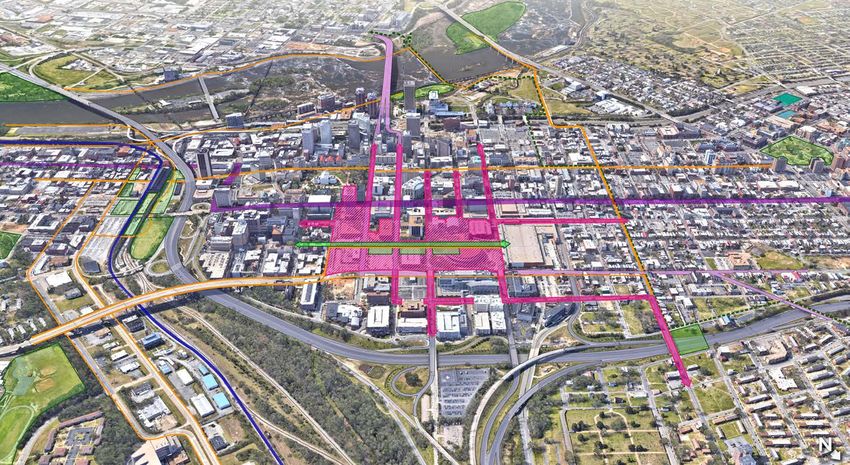
Development Clusters Science and Office Cluster benefits from proximities to reynolds
Community College, VCu Health, and the VA Bio+Tech Park with
Hotel & Entertainment: Situated adjacent to the eastern edge
mixed-use office buildings being shown near the edges of City
of the Greater Richmond Convention Center, the Hotel and
Center in Blocks 4 and 8 . This cluster also includes a public high
Entertainment Cluster includes the development of over 800 hotel
school on Block 8 which could build partnerships with adjacent
rooms (Figure 16). A Headquarters Hotel could locate on Block
higher education institutions and life science anchors .
1A and connect directly into the Convention Center and include
active ground floor uses to engage with the open space. While Municipal: City functions should be realigned and consolidated to
the existing parking garages on Blocks 5 and 9 may remain in reduce the footprint of City facilities in the City Center area .
the near-term, these present opportunities for additional hotel Explore the creation of a STEM-focused public high school and a
and mixed-use development. Block 6 can accommodate several fire station within City Center.
mixed-use buildings in addition to rehabilitating the Blues Armory
Building to accommodate uses, such as, meeting spaces and Networks
a food hall. This cluster could incorporate other entertainment Street Network: City Center has a gridded street network through
venues including a movie theater, performances spaces, and art the reintroduction of N . 6th Street from e . Broad Street to a new
galleries. All buildings should include active ground floor uses connector road parallel to e . Leigh Street and e . Clay Street from
including retail and restaurants. Buildings should engage with N . 10th Street to N . 5th Street .
the adjacent streets and open spaces to enhance the pedestrian Bicycle Network: introduce bike lanes on N . 5th, N . 7th, and Leigh
environment. Streets .
Residential: City Center’s redevelopment could include over 2,000 Transit Network: Develop N . 8th Street, N 9th Street, and/or E.
residential units with neighborhood amenities including a grocery Marshall Street as a transit mall with dedicated bus lanes and bus
store. Block 2 should be developed with mixed-use buildings to parking . incorporate enhanced transit on N . 8th and N . 9th Streets
serve the residents and employees within City Center and the to include potentially a North-South BrT (Bus rapid Transit) .
surrounding neighborhoods. A fire station to serve Downtown
Open Space Network: Develop open spaces of varying scales on
should be included in Block 3 within a mixed-use building.
e . Clay Street and N . 10th Street .
Life Sciences and Office: City Center will become an Innovation
District to encourage the growth of entrepreneurship, creativity,
and innovation, specifically in the Life Science fields. The Life
26 | City Center Small Area Plan DRAFTFigure 16 // Site Plan with Potential Development Clusters
DRAFT Plan Overview | 27High-Quality Places
Guiding Principles: Intentionally redevelop City-owned properties within City Center to create a walkable, beautiful, and distinctive
neighborhood with high standards of urban design. Establish a series of connected public open spaces that enrich and enliven City
Center. Integrate a diverse mix of uses to complement the surrounding context and incorporate activated ground floors to enliven
the area.
City-Owned Assets – John Marshall Courts Building: Explore options for a new
Courts Building, including a major renovation of the existing
Efficiently manage City-owned land and facilities.
building, rebuilding another Courts Building on the same parcel,
City Center is home to multiple City-owned assets including City or relocating the Courts Building elsewhere.
Hall, the John Marshall Courts Building, the Richmond Coliseum,
– City Hall: Explore options for City Hall, including a major
and multiple parking lots and garages (Figure 17). While some
renovation of the existing building, rebuilding another City Hall
civic uses will remain in the area including City Hall functions,
on the same parcel, or relocating City Hall elsewhere in City
other uses will be relocated or eliminated to allow for the
Center. Evaluate which City services and offices need to located
redevelopment of the parcels by private parties. The majority of
in the new City Hall building and which uses can be located
the City-owned structures have significant maintenance issues
outside of City Center. Design City Hall to be welcoming to
and continued maintenance to prolong their useful life is not
citizens and engage with the street. Explore incorporating
appropriate (Figure 3).
amenities in to complement the Transit Mall, including
Objective: restrooms and GRTC information.
Utilize a real estate management and disposition strategy, – Richmond Coliseum: Demolish the Coliseum, re-establishing the
prioritizing increasing jobs, housing, access to parks, and other street network and city blocks that existed prior to the 1970s.
basic needs of low-income and traditionally marginalized Private development on the Coliseum site should complement
communities. (See the Equitable Development Scorecard for the adjacent Convention Center and include significant open
specific requirements for private development on City-owned space.
land).
– Theater Row Building (730 E. Broad Street): Evaluate the
Strategies: needs of existing City uses and potentially relocate to a
– Continue to study the needs of City functions in this area centralized City Hall building and/or off-site locations to allow
following the release of the Department of Public Works for the redevelopment and adaptive reuse of this building.
Facilities Plan in Fall 2021.
28 | City Center Small Area Plan DRAFTRichmond Coliseum
Parking
Parking
Parking
Parking Parking
John Marshall Courts
Public Safety Bldg.
Theater Row Bldg.
Social Services Bldg.
Parking
City Hall
Figure 17 // Existing Conditions
– Department of Social Services Building: The City’s social – Parking Lots: Redevelop City-owned surface parking lots and
service delivery model is moving towards providing services parking decks to a higher and better use, while also providing
within the communities they serve, and therefore a centralized multi-modal transportation options.
DSS building may no longer be needed. Some DSS services – New Fire Station: To meet the demands of the increased
could be relocated to the City Hall building and in locations population Downtown, a new fire station should be included
throughout the City. Private development on this site should in the redevelopment of City Center. At the request of the
complement the adjacent VCU Health Campus and potentially Fire Department to meet service needs and have access to
include municipal uses as well. primary through-streets, the station should be located on the
– Public Safety Building: In 2021, the City approved the sale of block between E. Leigh, E. Clay, N. 8th., and N. 9th. This station
the Public Safety Building for the purpose of providing for the does not need to be a standalone use and can be included in a
private development of a mixed-use project that will serve the mixed-use building.
VCU Health facility.
DRAFT High-Quality Places | 29Open Space
fountains, and street furniture to make each of the spaces
Define the area with great public open spaces. unique and offer different features and amenities. The plan
Currently, City Center’s public open spaces are not activated and proposes three forms of open space:
lack trees, plantings, and other green space. While Festival Park 1. Large Signature Open Space: accommodates citywide and
hosted Friday Night Cheers and other events when the Coliseum community events (See description of flexible open space).
and 6th Street Marketplace were active destinations, today it sits
2. Linear Open Space: provides neighborhood amenities and
vacant. The open space near the John Marshall Courts Building is
regional destinations including areas for civic engagement,
composed of hardscaping and limited vegetation. The City Center
playgrounds, engaging public art, outdoor dining, and
Plan proposes to create open spaces of various scales adjacent to
recreational amenities.
active uses (Figure 18). These public spaces will provide various
destinations for residents, visitors, and Downtown workers. 3. Smaller Open Spaces: provide opportunities for outdoor
dining and interaction with the adjacent ground floor
Objective: commercial uses. These open spaces provide visual
Increase neighborhood and citywide access to, and through, with connectivity into the City Center from major intersections
a well-designed network of open spaces within City Center which including 5th and Clay Streets and 9th and Broad Streets.
provide destinations for City Center residents and visitors.
– Make flexible open spaces, such as festival streets, that draw
Strategies: residents and visitors to City Center through programming
– Create great public spaces through the development of initiatives. Develop E. Clay Street and N. 6th Street as festival
multiple signature open spaces in City Center. Program the streets which can be temporarily closed to vehicular traffic to
open spaces with events throughout the year. Incorporate allow for incorporation of these streets in the adjacent open
elements such as outlets to support food trucks, playgrounds, spaces.
Signature Open Space
The main plaza at the intersection of 6th and Clay Streets can be programmed
for various activities and serve as a citywide convening space. The space can host
concerts, festivals, outdoor movies, and holiday events including ice skating and
tree lighting. The park also is active with everyday uses such as outdoor dining
through movable seating, active and passive recreation, and amenities for families
including water features and playgrounds. The main plaza can also host events
programmed by the Convention Center to expand their offerings to potential
conference organizers.
Everyday Use
30 | City Center Small Area Plan DRAFTLarge Signature Open Space
1
3 1 2 3
3
Small Open Space
3
3
Linear Open Space
2
Figure 18 // Green Space
Outdoor Performance/Concert Ice Skating Rink
DRAFT High-Quality Places | 31Urban Design
– Develop public art projects to elevate City Center’s unique
Create a distinctive neighborhood with high-quality character and history through creative placemaking.
design and activated streets. – Implement public realm standards to include shade trees, bike
Urban design refers to how the built environment looks and parking, bike share, signage, public art, screened parking, street
feels, how buildings relate to one another, and how the “public furniture, pedestrian-level lighting, and other elements in the
realm” (streets, sidewalks, parks, etc.) enables such uses to public right-of-way that enhance placemaking and walkability.
function. Currently, most buildings within City Center have limited
engagement with the public realm due to lack of good building
design and active ground floor engagement. The design of the
new buildings as a part of the redevelopment of City-owned
assets will contribute to a new dynamic neighborhood (Figure 19).
Objective:
Develop City Center into a high-quality, distinctive, well-designed,
walkable neighborhood that is accessible to all ages and abilities
through best practices of urban design and activated ground floor
uses.
Strategies:
– On development sites that encompass most of a city block
or block frontage, require multiple buildings and/or façade
articulation to increase visual interest, require massing that is
responsive to the human scale, and include pedestrian through-
block connections through existing super blocks to reestablish
a street grid.
– Require buildings to meet the six design elements outlined in
the Pulse Corridor Plan: Hold the Corner, Appropriate Setbacks/
Stepbacks, Entrances Face the Street, Transparency, Façade
Articulation, and Screened Parking/Services.
– Require the podiums of tall buildings to reflect the human scale,
with design elements and active uses on the ground level.
32 | City Center Small Area Plan DRAFT1
Today
4
D 2
C 3
A
B
E
F
Responsibilities of the Public Realm: Responsibilities of the Private Realm:
A Thoroughfares designed for vehicle speeds below 25 1 Location of all off-street parking, both surface and structure,
mph for a sense of comfort and safety. screened from street view.
B Sidewalks shaded with street trees. 2 Shopfronts maximize transparency with clear windows.
C On-street parking serves as a buffer for people walking 3 Main building entries face the sidewalk to increase activity on
and dining, helps reduce vehicle speeds, and provides the street.
convenient parking for shoppers and guests. 4 A sufficient amount of openings facing the street, such as
D Defined “Furnishing Zone” allowing placement of trees, windows and doors, create interest and enhance security.
bicycle parking, parking meters, street lights, and other
streetscape elements.
E Walkways are wide enough to allow at least two people
to walk side-by-side comfortably.
F Encourage outdoor dining so long as an adequate
walkway width is maintained.
Figure 19 // Rendering of north side of E. Clay Street between N. 8th and N. 9th, facing west
DRAFT High-Quality Places | 33Historic Preservation
Preserve and enhance historic and cultural resources.
The City Center area is home to several historic structures
that should be protected while allowing for adaptive reuse of
structures and growth within City Center (Figure 20). Efforts
must be made to protect these historic resources while allowing
for the adaptive reuse of structures and growth within City Center.
Connections to historic resources within City Center and other
parts of Downtown should be prioritized.
Objective:
Support growth that preserves the historical urban fabric and
enhances understanding of City Center’s multifaceted past.
Strategies:
– Preserve culturally, historically, and architecturally significant
buildings, sites, and structures in City Center:
Blues Armory
– Rehabilitate Blues Armory, utilizing preservation best practices
to accommodate new uses, which may include a food hall,
entertainment venue, and conference space.
– Create a new open space adjacent to John Marshall House that
complements the historic resource. John Marshall House should
remain as a cultural asset within City Center.
– Connect City Center to cultural and historic resources
throughout Downtown through wayfinding and strong
streetscapes.
– Broaden the constituency for historic preservation by more
equally representing, preserving, and sharing the sites related
to traditionally underrepresented groups, such as Blacks, who
were displaced from this area in the mid- to late-20th Century.
John Marshall House
34 | City Center Small Area Plan DRAFTMaggie Walker
Historic Site
Hippodrome
Theater
Valentine Museum
White House of
the Confederacy
Blues Armory John Marshall House
Egyptian Bldg.
National Theater Monumental Church
Old City Hall
St. Peter’s Church
Dominion Arts Center
State Capitol
St. Paul’s Church
Figure 20 // Historic Sites
DRAFT High-Quality Places | 35Equitable Transportation
Guiding Principles: Prioritize the movement of people over the movement of vehicles through a safe, reliable, equitable, and
sustainable transportation network, promoting easier and safer access to and through City Center. Seamlessly connect City Center
to Richmond neighborhoods and other nearby attractions through enhanced pedestrian, bike, transit, and vehicular access and
connectivity.
Bicycle Infrastructure Pedestrian Experience
Expand the bicycle network. Enhance access and safety.
Objective: Objective:
Expand and improve on-street networks and amenities serving Improve the pedestrian experience throughout City Center by
bicyclists and other non-motorized vehicle users. improving sidewalks and improving pedestrian crossing and
streetscapes for all ages and abilities.
Strategies:
– Expand, improve, and maintain on-street bike connections, Strategies:
prioritizing the creation of separated or buffered bike lanes on – Require developers to construct sidewalks as a part of
5th Street, 7th Street, and Leigh Street (Figure 19). development projects per the Better Streets Manual to include a
– Expand the bike sharing program to include more stations clear width travel way, a building frontage zone, and a furniture
within City Center. or buffer zone.
– Install amenities (e.g., shelters, benches, parking, maintenance – Require developers to design and build projects to provide
tools, restrooms, water fountains with bottle-refill stations) and maintain street trees on both sides of at least 60% of new
through City Center. and existing streets within the project (and on the project side
of bordering streets) or to provide and maintain trees that
– Require secure and easily accessible short-term and long-term supply shade over at least 40% of the length of sidewalks on
bicycle parking and storage facilities within new development streets within or contiguous to the project within ten years of
projects. installation.
– Improve street furniture, plant shade trees, and install
pedestrian-level lights and other streetscape improvements.
– Create a festival street on Clay and 6th Streets that can be
closed to vehicles on certain occasions.
36 | City Center Small Area Plan DRAFTBelle
Isle
idge
Manchester Br
Brown’s
Island
James River
Main St. Main St. Franklin St.
State
N. 9th St.
N. 6th St.
N. 8th St.
Station
Capitol
Broad St.
ay
W
Marshall St.
ill
rH
Clay St. Convention
ive
Center
N. 3
Ol
N.
rd S
Leigh St.
1st
N. 7th St.
St.
N. 5th
t.
St.
I-95
I-64
Figure 21 // Neighborhood Connections
DRAFT Equitable Transportation | 37Streets and Connections Parking
Reconnect the urban grid. Implement innovative parking solutions.
Objective: Objective:
Strengthen the street network in City Center by preventing Implement parking strategies that effectively manage supply and
superblocks and encouraging gridded street networks to knit demand of parking in City Center and limit the development of
together the surrounding neighborhoods. surface parking lots.
Strategies: Strategies:
– Reconnect 6th Street from Leigh Street to Broad Street. – Demolish the Coliseum and use the Coliseum pit as
– Reconfigure Clay Street to bring it to grade between 5th and subterranean parking that is accessed from E. Leigh Street.
7th Streets and reconnect the street between 9th and 10th – Determine the need for City-owned parking decks/surface
Streets. Design Clay Street with festival street features such parking lots in the near-, mid-, or long-term, and prioritize the
as a curbless right-of-way that uses bollards and paving to redevelopment of surface parking lots.
differentiate pedestrian and vehicular areas. – Discourage the creation of new surface parking lots or parking
– Construct a street parallel to Leigh Street to connect 5th and garages in City Center. Surface parking lots are prohibited in
7th Street while allowing Leigh Street to remain below grade the current Zoning district.
to provide access to parking beneath the development at the – Encourage the development of innovative parking solutions
existing Coliseum site. including automated parking decks to minimize the square
footage required to store vehicles.
– Encourage any new parking garages to incorporate other
wrapped, activated uses.
– Encourage the shared use of parking by requiring the
developers of City-owned parcels to make all appropriate
parking on their project site available to the public for parking
after standard business hours (weekday evenings after 6:00
p.m., weekends, and all legal holidays) until 12:00 midnight or
until the close of business of retail operations, whichever is
later.
38 | City Center Small Area Plan DRAFTYou can also read