Social Impact Assessment - Queenstown Arterials - Social Assessment Report
←
→
Page content transcription
If your browser does not render page correctly, please read the page content below
Social Impact Assessment
Queenstown Arterials
Prepared for Queenstown Lakes District Council
Prepared by Beca Limited

20 October 2020

                                                     Social Impact Assessment | 3334066 | NZ1-16846022-1 0.1 | 2 September 2020 | 1

                        Creative people together transforming our world
| Social Impact Assessment|

Contents

1   Introduction ........................................................................................................ 1
    1.1    Purpose and scope of this report .................................................................................................... 1
    1.2    Assumptions and limitations ........................................................................................................... 1

2   Project Description ............................................................................................ 2
3   Assessment Methodology ................................................................................ 4
    3.1    Preparation for this Report .............................................................................................................. 4
    3.2    SIA Process and Framework .......................................................................................................... 4
    3.3    Methodology overview .................................................................................................................... 4

4   Existing Environment ........................................................................................ 8
    4.1    Demographic Profile ..................................................................................................................... 11
    4.2    Landowner/resident/business owner survey ................................................................................. 16
    4.3    Community infrastructure .............................................................................................................. 17

5   Social Impact Assessment ............................................................................. 21
    5.1    Way of life ..................................................................................................................................... 21
    5.2    Community.................................................................................................................................... 23
    5.3    Health and well-being ................................................................................................................... 30
    5.4    Quality of living environment and amenity .................................................................................... 30

6   Summary .......................................................................................................... 33

Appendices

Appendix A - Survey Questions
Appendix A – Survey Questions
Appendix B – Survey Summary and Results

                                                                                 Social Impact Assessment | 3334066 | NZ1-16846022-1 0.1 | 2 September 2020 | i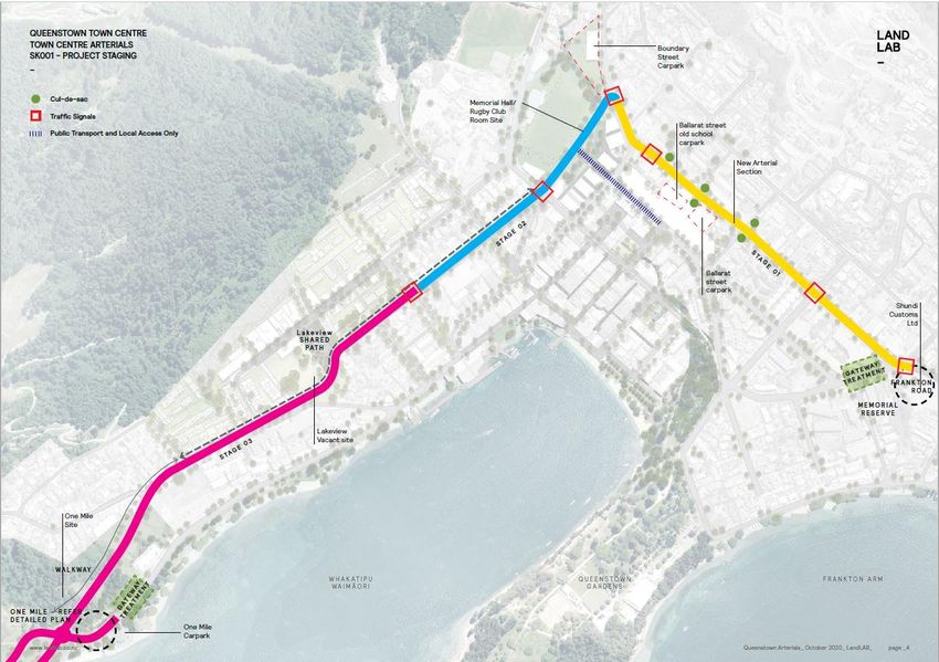
| Social Impact Assessment|

Revision History
 Revision Nº              Prepared By                                      Description                                                            Date
 1                        Jo Healy                                         Draft for client                                                       6/10/2020

 2                        Jo Healy                                         Final Draft                                                            16/10/2020

 3                        Jo Healy                                         Final Report                                                           20/10/2020

Document Acceptance
 Action                   Name                                             Signed                                                                 Date
 Prepared by              Jo Healy                                                                                                                20/10/2020

 Reviewed by              Amelia Linzey                                                                                                           20/10/2020

 Approved by              Stephen Hewett                                                                                                          20/10/2020

 on behalf of             Beca Limited

© Beca 2020 (unless Beca has expressly agreed otherwise with the Client in writing).
This report has been prepared by Beca on the specific instructions of our Client. It is solely for our Client’s use for the purpose for which it is intended in accordance
with the agreed scope of work. Any use or reliance by any person contrary to the above, to which Beca has not given its prior written consent, is at that person's own
risk.

                                                                                           Social Impact Assessment | 3334066 | NZ1-16846022-1 0.1 | 2 September 2020 | ii
| Introduction |

1      Introduction

1.1 Purpose and scope of this report
This Social Impact Assessment (SIA) is a specialist technical report prepared by Beca Ltd for Queenstown
Lakes District Council’s (QLDC) Queenstown Arterial Project (the Project). This report will inform the
Assessment of Environmental Effects (AEE) Report and support the resource consent and notice of
requirement application required for the construction and operation of the arterial.
This report assesses the actual and potential construction and operational social impacts of the Project. The
assessment is based on the Designation and Scheme Design Drawings for the Project provided in the AEE.

The purpose of this report is to:
●   Identify and describe the existing social environment;
●   Identify and assess the potential social impacts (positive and negative) of the Project (both from
    construction and operation);
●   Recommend potential measures, as appropriate to avoid, remedy or mitigate potential adverse social
    impacts; and
●   Present an overall conclusion on the level of potential adverse and positive social impacts of the Project
    assuming that recommended measures are implemented.

1.2 Assumptions and limitations
The Project requires relocation of a number of council assets and community facilities that currently lease
sites on council land. It also includes changes to parking provision and use of council road frontage. In some
instances, these areas are used for private use (e.g. parking for private businesses or community assets).
While it is recognised that council can reorganise council space at any time, including use of roads, there are
potential social consequences arising from such works (e.g. for those using these facilities). In this respect,
the mitigation and management proposed focuses on potential opportunities to manage or mitigate the
impacts on these community values, within the bounds of the consenting and designation process.
This report has been based on the level of detail of construction and operation currently available for the
project. Many of the details of property / service relocation are not available at the time of the Application and
this assessment. For this reason, this SIA considers the potential consequences of the property / service
requirements that will need to be relocated for the Project in order to recommend measures to minimise
social impacts of such relocation (rather than an assessment of any specific proposed new locations).
Where measures are proposed or recommended to address potential social impacts identified further
assessment of the ‘post-mitigation effects’ are also commented on.

                                                            Social Impact Assessment | 3334066 | NZ1-16846022-1 0.1 | 2 September 2020 | 1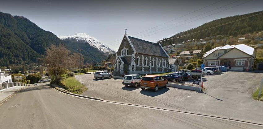
| Project Description |

2      Project Description
The Arterials Project is described in detail in the AEE, the following is to provide context for the social impact
assessment.
Briefly, the Project involves the creation of a new arterial road that delivers an alternative urban route around
Queenstown’s commercial area. The new route commences at the Frankton Road / Suburb Street
intersection then circuits the town centre along Melbourne Street, Henry Street, Gorge Road, Memorial
Street, Man Street, Thompson Street, and down to a new One Mile roundabout at the Fernhill Road/Lake
Esplanade/Glenorchy Road intersection. The route is depicted in Figure 1 below.

The project will be constructed over three stages as indicated below:

Figure 1: Queenstown Arterials Site Stages (Yellow Stage 1, Blue Stage 2 and Pink Stage 3) Source Land Lab Arterial
Report October 2020.

It is understood that work will be constructed over 3 stages and will occur over time. For the purpose of
considering construction effects, it is assessed that each stage of the project will take over a year to
construct with stage 3 being approximately 83 weeks (nearly two years).

The project will provide:
●   Road widening
●   Signalised intersections (see above)
●   Pedestrian overpass
●   Footpath improvements
●   Pedestrian refuges in centre medians at selected crossing points
●   Shared path provisions for parts of the corridor (see above)

                                                              Social Impact Assessment | 3334066 | NZ1-16846022-1 0.1 | 2 September 2020 | 2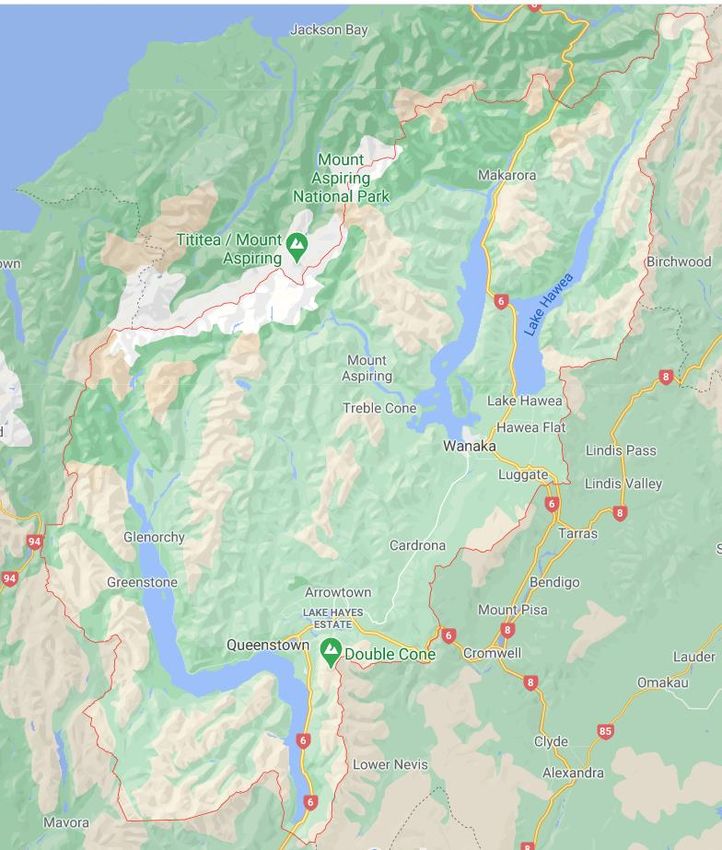
| Project Description |

●   Street upgrades within project
●   Changes to parking provisions
●   Relocation of school drop-off point (St Joseph’s School)
●   Creation of cul-de-sacs
●   Turning restrictions
●   New connections (sections of road)
●   Changes to property access

Refer to the Transport Assessment for full details.

Below are construction activities required relevant to the social impact assessment:
●   Removal of the Queenstown Memorial Centre (with associated community activities to be accommodated
    in alternative facilities elsewhere)
●   Removal of the Squash Club
●   Removal of the Rugby Club
●   Construction of footpaths on the perimeters of James Clouston Reserve and Queenstown Recreation
    Reserve (perimeter land requirements)
●   Changes to property accesses
●   Temporary access restrictions (street and property)
●   Construction yard within Queenstown Recreation Reserve (duration up to 1 year)
●   Removal of parking from Thompson Street, Man Street, Memorial Street, Gorge Road, Henry Street, with
    most removed from Melbourne Street except for six drop off/pick up car parks associated with St
    Joseph’s School
●   Reconfiguration of road reserve

For further detail on the above construction activities and project provisions, the Transport Impact
Assessment report provides further detail.

                                                           Social Impact Assessment | 3334066 | NZ1-16846022-1 0.1 | 2 September 2020 | 3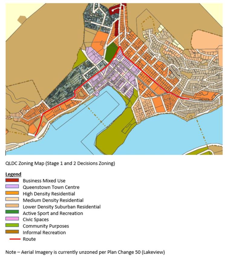
| Assessment Methodology |

3      Assessment Methodology

3.1 Preparation for this Report
The preparation for this report has included:
●   A site visit to the project area and surrounds
●   Review of other technical reports including noise and vibration, transport, landscape and visual and
    proposed construction methodology
●   Review of previous stakeholder and community engagement (led by QLDC)
●   Review of landowner meetings – property team (available at time of reporting)
●   Stakeholder interviews conducted by the SIA reporting team
●   Review of resident survey (conducted by SIA team).

3.2 SIA Process and Framework
The International Association of Impact Assessment (IAIA) defines a Social Impact Assessment as:
‘…the process of analysing, monitoring and managing the intended and unintended social consequences,
both positive and negative, of planned interventions (policies, programs, plans, projects) and any social
change processes invoked by those interventions’.
The IAIA notes that SIA can be undertaken in different contexts and for different purposes, but that the
following principle is important across all SIA:
‘The improvement of social wellbeing of the wider community should be explicitly recognised as an objective
of planned interventions and as such should be an indicator considered by any form of assessment.
However, awareness of the differential distribution of impacts among different groups in society, and
particularly the impact burden experienced by vulnerable groups in the community should always be of prime
concern’
The methodology adopted for this SIA has been developed to identify and predict the key social impacts of
the construction and operation of the Project from the perspective of those potentially affected by it to
support the AEE prepared for the resource consent and notice of requirement applications.

3.3 Methodology overview
3.3.1 Scoping
a. Community data

The following information sources and methods have been used to prepare this SIA:
●   Census data: to provide a demographic profile of the community as recorded by Statistics New Zealand
    Census 2018 (where data is available), 2013 and 2006 (where relevant);
●   Council studies:
    – Demand Projections Summary July 2020
    – Quality of Life Report 2019
    – Our Community Spaces 2018
b. Site visit
A site visit was undertaken along the proposed corridor between 14th - 17th September 2020. This included
walking along the proposed corridor and visiting community facilities.

                                                          Social Impact Assessment | 3334066 | NZ1-16846022-1 0.1 | 2 September 2020 | 4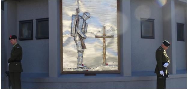
| Assessment Methodology |

c. Social Research - Consultation
i. Landowner/resident/business owner survey
As part of project communications QLDC issued a project update letter to owners and occupiers along the
project corridor (802 Owner/Occupiers), this included invitations to participate in the online social research
survey. In addition, a link to the survey was available from the QLDC website.
They survey had general questions for all groups about the length of time that the respondent had been
living or operating a business out of that location and perceptions on the benefits and restrictions/issues with
the location. As the project corridor contains residential properties a separate set of questions were provided
between residential and business purposes of property (see Appendix A for survey questions).
The response rate to the surveys was very low at 1.4% (11 responses), limiting representation of the existing
environment but provided base information for further investigation.
ii. Stakeholder interviews
Between the 14th September and 2nd October stakeholder interviews were undertaken (in person and/or by
phone/video call) with:
●   St Joseph’s Primary school
●   St Joseph Church
●   QLDC Councillor
●   Queenstown Chamber of Commerce
●   Parks and recreation – QLDC
●   Event organiser (Reserve and Memorial Centre) – Private/QLDC collaboration – i.e. Waitangi Day and
    New Year’s Eve community celebrations
●   Memorial Centre Users
    – Queenstown Returned and Services Association
    – New Zealand Alpine Club
    – Showbiz
    – Michael Hill Violin Competition
    – Catalyst Trust
●   Queenstown Recreation Reserve users
    – Queenstown 9’s competition (and Memorial Centre)
    – Queenstown Marathon (and Memorial Centre)
    – Queenstown Fire Service – competition training and Fire Service 7’s event
    – Queenstown Commercial Parapenters (Gforce)
●   Wakatipu Rugby Club (also uses the reserve)
●   Wakatipu Squash Club
●   Wakatipu Senior Citizens Association

3.3.2 Impact identification and assessment

This report identifies and assesses the key social impacts potentially experienced by the community during
construction and operation of the Project.
The SIA process documented in this report has used the IAIA guidelines to consider the potential social
impacts of the Project, on the basis of the existing community, the nature of the proposed works, and the
consequential social impacts anticipated.

                                                           Social Impact Assessment | 3334066 | NZ1-16846022-1 0.1 | 2 September 2020 | 5
| Assessment Methodology |
The IAIA describes a range of social impact categories. The IAIA categories have been used as a guide and
the following selected as most relevant to this project1:
● People’s way of life – how they live, work, play and interact with one another on a day-to-day basis;
● Their community – its cohesion, stability, character, services and facilities;
● Their health and wellbeing – health is a state of complete physical, mental, social and spiritual
wellbeing and not merely the absence of disease or infirmity;
● The quality of the living environment and amenity– the quality of the air and water people use,
availability and quality of the food that they eat, the level of hazard of risk, dust and noise they are
exposed to, the adequacy of sanitation, their physical safety, and their access to and control over
resources.
Geographic extent
Following analysis of the proposed designation and extent of works for the Project and the surrounding area,
two geographical extents are considered relevant to the assessment:
● Regional scale: The Queenstown Lakes District
● Project extent: The area adjacent to the proposed designation and associated works
Rating
The assessment of social impact is considered as either: positive or negative on the basis of whether the
anticipated social consequences will either enhance or detract from the community values, social processes
or social infrastructure identified in the Community Profile.
The scale of impact is identified as either very low (negligible), low, moderate, high or very high. This
assessment is made on consideration of the likelihood, duration and scale of the impact relative to the
existing environment (in other words the degree of change from the existing condition) and distribution (e.g.
number of people impacted) of the impact. The following provides an overview description of the assessment
scale:
● Very Low (negligible):
– Short/term temporary duration (temporary e.g. weeks/months);
– Small extent of impact on the community being considered (e.g. less than 10% of community extent)
and
– Very low or negligible level or severity of impact (the degree of change anticipated to the community
system, process or value identified in the community profile assessed at a community level).
● Low:
– Transitional duration (e.g. months or for periods of construction activity);
– Small to medium extent of impact on a community (e.g. between 10% and up to 50% of a community
impacted – factoring severity); and
– Low level of severity of impact (there is low degree to which it will affect the community systems,
processes and values identified in the profile).
● Moderate:
– Transitional to long-term duration (e.g. months to years, e.g. impacts that will extend over and
throughout a construction period or beyond);
– Medium scale or extent of impact for community (e.g. likely to impact half or more of an identified
community extent); and
– Low to moderate level of severity of impact.
1
International Principles for Social Impact Assessment 2003 – SIA principles – Frank Vanclay
Social Impact Assessment | 3334066 | NZ1-16846022-1 0.1 | 2 September 2020 | 6| Assessment Methodology |
● High:
– Long-term duration (e.g. years to permanent impact);
– Medium to large scale extent of impact for community (e.g. likely to impact more than half of an
identified community extent); and
– Moderate to high level of severity of impact (the degree to which it will affect the community systems,
processes and values identified in the profile).
● Very High:
– Long-term duration (e.g. more likely to be permanent;
– Large extent or scale of impact for community (e.g. most of a community is likely to experience this
impact; and
– Significant severity (e.g. is likely to result in major change to the community system, process or value
identified in the community profile).
Social Impact Assessment | 3334066 | NZ1-16846022-1 0.1 | 2 September 2020 | 7| Existing Environment |
4 Existing Environment
Queenstown-Lakes District is a local government district within the Otago Region (Figure 2). The population
of the district increased nearly 39% between 2013 and 2018, with approximately 39,153 people living in the
district as of 2018. Queenstown is the most populous town in the district.
Figure 2: Queenstown Lakes District – wider area
The Project is located in Queenstown Central area. Figure 3 below shows the approximate location of the
Project in relation to suburbs within Queenstown including Frankton to the east and Fernhill to the
Southwest. As demonstrated it is centrally located within Queenstown and will form an alternative link
between the western and eastern suburbs of Queenstown and the surrounding towns such as Glenorchy to
the north west and Wanaka to the north east.
Social Impact Assessment | 3334066 | NZ1-16846022-1 0.1 | 2 September 2020 | 8| Existing Environment |
Figure 3: Project in relation to Queenstown suburbs
Social Impact Assessment | 3334066 | NZ1-16846022-1 0.1 | 2 September 2020 | 9| Existing Environment |
Figure 4 below shows the arterial route with regard to landuse in the area as demonstrated by the
Queenstown Lakes Proposed District Plan zoning. As indicated by the zoning the Project borders the
Queentown town centre and the periphery which is zoned high density residential and is a mix of private
(permanent and holiday residences) and commercial accomodation (hotels/backpackers/Air-bnb and holiday
rentals) and community resources. The imagery below also indicates the future Lakeview Development –
which is planned to be a mixed development functioning as a complementary extension to the current town
centre.
Figure 4: Project in relation to QLDC zoning
Social Impact Assessment | 3334066 | NZ1-16846022-1 0.1 | 2 September 2020 | 10| Existing Environment |
4.1 Demographic Profile 2
Queenstown Lakes District has noted high rates of growth; in 2018 it had the highest growth rate in New
Zealand3. Between 2013 and 2018, the District grew by an average of 7% each year, totalling nearly 39%
over the five-year period. The District has a large tourist population, with the number of overseas visitors
increasing4, exceeding the numbers of permanent residents. The number of international visitors was
previously expected to triple in the next 10 years5. It is noted that these forecasts were made pre pre-COVID-
19 and will be subject to revision in due course, to reflect current border controls and future travel behaviours
as they evolve.
The Project traverses three ‘suburb areas’ (defined Census Area Units); Queenstown East, Queenstown
Central and Warren Park. Locally, this is area is referred to as the Queenstown Central Community including
Queenstown Town Centre. The only identifiable neighbourhood within this is area Queenstown Hill (Warren
Park) of which the southern section is within the project area. These areas are identified in this SIA, as the
project area. The Project route relative to those Census Area Units is shown in red below.
2
It is noted that all statistics are derived from Statistics New Zealand, as a result of the 2013 and 2018 Census unless
otherwise identified.
3
https://www.odt.co.nz/news/national/queenstown-lakes-fastest-growing-nz
4
https://www.stats.govt.nz/news/queenstown-visitor-numbers-snowball note that this is prior to the COVID-19 global
pandemic.
5
https://www.qldc.govt.nz/media/nazhf4fd/1803-sustaining-tourism-growth-in-queenstown-final-report.pdf page 3
Social Impact Assessment | 3334066 | NZ1-16846022-1 0.1 | 2 September 2020 | 11| Existing Environment |
Figure 5: Project area
4.1.1 Housing
The project area has a small portion of the district’s private residential dwellings (see Table 1 below). The
Queenstown Central census area contains the majority of the retail and central business activities out of
these areas (making up the project area and excluding other retails centres such as Frankton). It does have
areas of high-density residential living, but it predominantly contains town centre/business activities.
Queenstown East and Warren Park, while also containing some other activities including retail,
accommodation and tourism, are predominantly residential (both holiday homes and Air-bnb’s as well as
permanent homes).
Table 1: Housing and Ownership
Queenstown Queenstown Queenstown Warren Park
Central East
Total Private Dwellings 19,845 435 909 486
Occupied 13,719 285 483 399
Unoccupied 5,418 144 417 84
Under construction 705 6 15 6
Social Impact Assessment | 3334066 | NZ1-16846022-1 0.1 | 2 September 2020 | 12| Existing Environment |
Ownership
Owned (or partly owned) by 39% 11% 25% 18%
occupier
Owned by a trust 37% 9% 14% 4%
Owned by other (not by 24% 80% 61% 78%
occupier)
The Queenstown Lakes District had approximately a 69% occupancy rate for private dwellings whilst the
project area averages 64% (noting that this is as low as 53% in Queenstown East). The proportion of owner-
occupied properties in the project area is significantly lower than in the remainder of the district.
The median weekly rent in the Queenstown Lakes District was $530 per week in 2018. This was the same
median cost as Warren Park, which has seen an increase from $360 per week in 2013. The weekly median
rent in Queenstown Central was $380, an increase from $290 in 2013. Queenstown East was the most
expensive of the three areas, at $650 per week, up from $430 in 2013. 2020 statistics from a Queenstown
Lakes District Council report states that private sector rents averaged $650 a week pre-COVID but were
trending down, sitting at just over $500 per week in August 2020.
4.1.2 Population and Ethnic Composition
The population of Queenstown Lakes District increased 39% between 2013 and 2018, as identified in Table
2. Within the project area, there has been an overall net increase in population by 10% over this same time
(it is noted that within the project area is the Queenstown Lakeview Development which is yet to commence
construction but will include residential buildings, hotels, co-working and co-living spaces, hospitality and
retail, and a hot pools attraction.). The reported growth is reflected in the traffic and infrastructure pressures
noted by the project and anecdotally by stakeholders interviewed. Initial statistics provided by QLDC in 2020
indicate a likely slowdown in predicted growth over the next 10 years.
Table 2: Population and ethnic make up6
Queenstown Queenstown Queenstown Warren Park
Lakes District Central East
Population 2013 28,224 1,047 1,362 1,131
Population 2018 39,153 1,017 1,416 1,485
Population change between +10,929 -36 (decrease +54 (increase of +354 (increase
2013/2018 (increase of of 3%) 4%) of 9%)
39%)
Average Median Age 34 30 31 29
6
It is noted that where a person reported more than one ethnic group, they were counted in each group.
Percentages may add up to more than 100% because of this. Percentages are rounded to nearest whole
number unless under 0.5%.
Social Impact Assessment | 3334066 | NZ1-16846022-1 0.1 | 2 September 2020 | 13| Existing Environment |
Queenstown Queenstown Queenstown Warren Park
Lakes District Central East
Female (count) 19,971 486 696 729
Male (count) 19,182 528 720 753
Percentages of ethnicities and birthplaces
European 84% 55% 74% 64%
Asian 10% 28% 19% 20%
Middle Eastern/Latin 5% 15% 7% 15%
American/African
Māori 5% 3% 2.5% 3%
Pacific Peoples 1% 1% 0.4% 1%
Other ethnicity 1% 1% 0.5% 1%
Birthplaces
Born Overseas 41% 82% 69% 79%
Born in NZ 59% 18% 32% 21%
Most people residing in both Queenstown and the project area identify themselves as European ethnicity
(however it is noted that the proportion is significantly lower within the project area). Within the Project area,
the second most identified ethnicity was Asian, at approximately 22%, while Middle Eastern/Latin
Americans/African make up approximately 15% of the population. Māori make up approximately 5% of the
population in the Queenstown Lakes District, and 3% (median) within project area.
41% of the population of Queenstown Lakes District was born overseas and 59% of its residents were born
in New Zealand. In the project area, a comparatively higher proportion were born overseas (between 69%
and 82%). The United Kingdom and Ireland and Asia were the highest percentage of birthplaces for those
who were born overseas.
In Queenstown Lakes District, 7% of people lived overseas one year prior to the 2018 census. In the project
area, there were more people living overseas one year prior (Queenstown East - 14%, Queenstown Central
– 19% and Warren Park 20%). Approximately 59% of people within the project area were living at the same
residence that they were one year prior to the census.
The median age in the project area is around 30 years of age. The population count, by age and sex, for
each statistical area within the project area, is set out below (Table 3).
Table 3: Percentage for age groups
Queenstown Queenstown Queenstown East Warren Park
Lakes District Central (M/F) % (M/F) %
(M/F) % (M/F) %
Under 15 years 17 / 17 6/ 5 5/6 8/5
Social Impact Assessment | 3334066 | NZ1-16846022-1 0.1 | 2 September 2020 | 14| Existing Environment |
Queenstown Queenstown Queenstown East Warren Park
Lakes District Central (M/F) % (M/F) %
(M/F) % (M/F) %
15-29 years 24 / 23 43 / 46 42 / 43 49 / 54
30-64 years 49 / 50 46 / 44 44 / 43 42 / 39
65 years and over 10 / 11 5/5 9/8 2/3
Table 3 indicates that there are less children and elderly residing within the project area comparative to the
District and significantly more young people aged between 15 and 29 years of age.
4.1.3 Income and Employment
It is noted that the statistics provided in the tables are from the 2018 Census and the economic and
employment climate has changed due to impacts from COVID-19.
Table 4: Employment and Income7
Queenstown Queenstown Queenstown Warren Park
Lakes District Central East
Full Time Employment 66% 82% 77% 85%
Unemployment Rate 1% 0.3% 1% 1%
Not in Labour Force 18% 10% 13% 7%
Median personal income $40,600 $34,300 $38,800 $34,200
Occupation
Top Occupation Managers Technicians Managers Community and
(22%) and trade (20%) personal
works (20%) service works
(24%)
Second top occupation Professionals Community Technicians Labourers
(17%) and personal and trade (17%)
services workers (17%)
workers (18%)
Third top Occupation. Technicians Managers Community and Technicians
and trade (18%) personal and trade
workers (16%) service workers workers (15%)
(16%)
7
2018 Stats NZ Place Summaries. Note, percentages are rounded to nearest whole number and a before
Covid-19 impacts.
Social Impact Assessment | 3334066 | NZ1-16846022-1 0.1 | 2 September 2020 | 15| Existing Environment |
Table 4 identifies the employment and income of the project area and District as of 2018. It also identifies the
most common occupations in the project area and District. In QLDC, 66% of people were in full time
employment, with an unemployment rate of 1%. This was lower than the national average of 4%
unemployment. A recovery update published by QLDC, October 2020 indicates that since the COVID-19
pandemic, the number of people receiving job seeker allowance has risen and is now approximately 2% and
that a job-loss rate is of at least 5%. QLDC data predicted (on the impacts to date) that there will be a 23%
contraction in the District’s GDP to March 2021, with a 25% job loss rate (5,000 in tourism, 800 in
construction alone).
The most common occupations tend to be the same (albeit in a different order) in the project area, with the
inclusion of labourers in Warren Park (instead of managers).
The median personal income in the project area was mid to late $30,000s which was lower than the median
income for the Queenstown Lakes District at $40,600. Queenstown East had the highest percentage of
people earning over $70,000 (14%), but this was less than the 20% of people earning over $70,000 in the
wider District, again this may be subject to impacts of COVID-19. For example, spending in the week ending
4th October 2020 (being the first week of school holidays) is 13% below 2019 levels at the same time. Since
the end of the national Level 3 lockdown in May 2020, spending has tracked between 10% and 30% below
last year, averaging 16% below 2019. Spending has been supported by higher than expected levels of
domestic tourism spending, which MBIE estimate at being 7% higher than 2019 (this is the current COVID-
19 pandemic situation).
4.1.4 Education
The majority of people living in the project area are not studying or undertaking further education
(approximately 89%). Of those who are studying, approximately 8% are full time and approximately 2% in
part time.
4.1.5 Transport
The most popular way to travel to work in the Queenstown Lakes District is driving a private vehicle (49%). In
comparison, in the project area the most popular way to travel to work is walking or jogging (between 36%
and 47%). Driving a private vehicle is second most popular, with 29-33% in the project area. Other methods
of transport include driving a company vehicle, being a passenger in a vehicle, bicycling, and working from
home.
In terms of travelling for education within the project area, the most popular way is walking or jogging. In the
Queenstown Lakes District, this is as a passenger in a car, truck or van.
4.2 Landowner/resident/business owner survey
The response rate for the resident’s survey was low with only 1.4% of the potential respondents along the
route filling out the survey. While not statistically significant, the survey was used as a preliminary screen for
further discussions points – used in the stakeholder interviews.
The survey was aimed at both businesses and residences along the arterial route and had different
questions for each group. 11 responses were received in total, with 3 being commercial/businesses, 3 being
homes owned but rented out, and 5 respondents who lived at the address.
Of those who responded as residents, most had lived the property for more than 10 years and it was the
proximity to town, lake and the natural environment that were key values of this location. Walking was
identified as the most popular common way to travel into the town centre, followed by private vehicle. The
proximity to the main road, noise during early hours of the morning, and the uncontrolled carparking were
some of the disbenefits of living at that location as identified by respondents.
Social Impact Assessment | 3334066 | NZ1-16846022-1 0.1 | 2 September 2020 | 16| Existing Environment |
Respondents were given a list of services and were asked to select those that they went into the downtown
area to access; shopping, healthcare entertainment and recreation were amongst the most frequently
accessed services within the town centre. No respondents identified accessing education in this area.
Only 3 businesses responded; 2 being accommodation providers and 1 a community service. Current
challenges they identified within this environment were the impacts of COVID 19, lack of parking, increased
traffic volumes and continued construction within the area. All had either limited off-site parking, and/or were
largely dependent on on-street parking.
The residents’ survey identified a number of key themes and issues including:
● Access within the project area, including to and from Frankton.
● Access to businesses within the project area.
● Concerns about the loss of sporting facilities and social/cultural amenities.
● Importance is placed on enhancing amenity along Melbourne street.
● Cycle and walking connections including underpasses to get to the lake.
● Vehicle lights at night and how this could be mitigated.
A full summary of the survey results can be found in Appendix B.
4.3 Community infrastructure
The project corridor is centrally located in relation to Queenstown town centre and correspondingly is
adjacent to or in close proximity to many community resources.
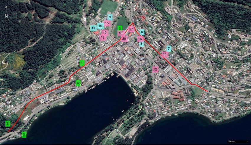
Figure 6 below identifies some key community infrastructure adjacent to or in close proximity to the Project.
Social Impact Assessment | 3334066 | NZ1-16846022-1 0.1 | 2 September 2020 | 17| Existing Environment |
Legend
Parks and reserves
1. James Clouston Memorial Reserve
2. Ben Lomond Scenic Reserve
3 Queenstown Recreation Reserve.
4. Rotary Park
5. Lookout Point Park
Educational facilities
6. Zig Zag Zoo Early Childhood Centre
7. St Josephs’ School
8. Queenstown Play Centre
9. Queenstown Primary School
10. Kidsfirst Kindergarten Wakatipu
11. Queenstown Preschool and Nursery
Community Facilities
12. St Andrew’s Presbyterian Church
13. Queenstown Medical Centre
14. St Joseph’s Parish
15. Freedom Church Queenstown
16. Plunket Queenstown
17. Queenstown Lakes District Library
18. Queenstown Memorial Centre
19. Queenstown Fire Station
20. Wakatipu Senior Citizens Association
Figure 6: Community Facilities
Social Impact Assessment | 3334066 | NZ1-16846022-1 0.1 | 2 September 2020 | 18| Existing Environment |
The following provides further details on key community facilities that have works on or in close proximity to
them:
Queenstown Memorial Centre
The Queenstown Memorial Centre is operated by QLDC and is located adjacent to the Queenstown
Recreation Reserve. It is a large venue (approximately 400 seats in the auditorium) that is used for a variety
of conferences, exhibitions, shows and other events by many different community groups (often annually).
The venue has the ability to offer a variety of seating and room options, as well as providing a commercial
kitchen, catering for different sized community events. It has outdoor facilities including a patio deck adjacent
to the Recreation Reserve and often provides catering and indoor space for events held at the reserve.
The Memorial Centre also houses the Returned and Services’ Association (RSA) providing a dedicated room
for military memorabilia, a library and weekly meetings. The Centre is a memorial to soldiers who have
passed in World War I and World War II and is the end location of the Anzac Day Parade and Service.
Figure 7: Soldiers in position beside the war memorial outside the Queenstown Memorial Centre following the official
Anzac Day service in Queenstown April 2019 (Source Otago Daily Times).
Queenstown Recreation Reserve
The Queenstown Reserve is one of central Queenstown’s largest green-spaces. The reserve is used for
formal (rugby field) and informal recreation and stormwater management. It hosts a variety of activities,
including Wakatipu Rugby Club matches, sporting events and community celebrations/ festivals. At times
due to its physical conditions it is subject to ponding and requires events to be temporarily relocated.
James Clouston Reserve
James Clouston Memorial Park is located along Hay Street. It was established in 1963, as a memorial to
James (Jim) Clouston, who was deputy mayor of Queenstown in 1956. It provides informal recreation and
neighbourhood greenspace.
St Joseph Church
St Joseph’s Parish is located on Melbourne Street. It is reported that church attendees are of mixed age and
ethnicity (including a large migrant community); visitors make up around 40% of attendees. Below outlines
the use of the church:
● Weekend Services: Saturday Evening/ Sunday Morning
Social Impact Assessment | 3334066 | NZ1-16846022-1 0.1 | 2 September 2020 | 19| Existing Environment |
● Weekday Services: Mon/Wed/Fri 9.30am service
● School assembly: Monday 9am
● Other uses: Weddings, Funerals, Baptisms
● Parish building is residence for Parish Priest
● Parish building holds small group meetings of church council, once per month
● School use Church for musical practice, larger events, significant dates on the Catholic calendar e.g.
nativity.
St Joseph’s School
St Joseph’s School (years 1-8) is a Catholic primary school located on the corner of Beetham and
Hallenstein Streets, in Central Queenstown. It is east of the proposed connection between Melbourne and
Henry Street. The current school roll is 135 children from 93 families and a team of 19 teaching and support
staff. Pupils are from all over Queenstown District (13 from central Queenstown). A small number (approx.
10%) of students bike to school. Most students bus or are dropped off by private vehicle. Buses come from
Gibbston/Arrowtown, Shotover/Lake Hayes Estate, Bobs Cove, Arthurs Point and are shared with
Queenstown Primary School. The bus stop is on Hallenstein St.
Wakatipu Rugby Club
Wakatipu Rugby Club is located adjacent to the reserve. Currently it has approximately 250 members (Junior
180, Seniors 70). Senior Men’s and Women’s home games are played at the reserve and on occasion a
junior game (noting that most junior games are played at the Event Centre grounds). Practices are at the
reserve when light allows (daylight savings) and alternately are held at the Event Centre, which is also used
as an alternative venue when ground conditions at the reserve are not suitable for games. The club owns the
building and leases the land and reserve use rights from QLDC. The club is used for viewing games, club
events and as a community events space for hire. The bar and venue hire are important revenue resources
for the club and fund the club operations.
Wakatipu Squash Club
Wakatipu Squash Club has 109 members. It has two courts and is used by members and for casual court
hire. Local annual events include Queenstown Open, Club Championships and Queenstown 1 day
tournament. The building is owned by the club and land leased from QLDC. The club does not hire out its
venue. There are no alternative squash courts for public use within the District.
Social Impact Assessment | 3334066 | NZ1-16846022-1 0.1 | 2 September 2020 | 20| Social Impact Assessment |
5 Social Impact Assessment
5.1 Way of life
Queenstown Central includes a tourist hub, entertainment for locals, sources of employment (retail,
hospitality and accommodation) and the base for many professional services. The periphery of the
downtown, where the project corridor is located, is a mix of accommodation (hotels/motels, short term lets,
holiday homes), businesses, community amenities and residential.
Downtown is identified as the “Heart of Queenstown” and although many locals perform many of their daily
activities in the perimeter suburbs it is seen as key to identity, a cultural hub and provides for many
recreational opportunities.
As well as a destination for tourism, employment and entertainment within Queenstown Central, the project
corridor provides a link between communities and businesses to the west and east of central Queenstown.
The project corridor contains destinations for work (mainly accommodation providers), living (single storey
and apartment building housing), community services (childcare, school, church, Plunket etc) and recreation
(parks, sporting clubs, Memorial Centre).
St Joseph’s School and Zig Zag Zoo (Childcare facility) are located adjacent to the project corridor and
provide for children from wider Queenstown. Frequent drop offs and pickups occur at these locations by
parents en-route to work and home.
Work:
The project has the potential to improve the way people work for those whose jobs necessitate traversing
through Queenstown from Frankton to Fernhill and beyond (or reverse). This includes freight that travels
through the area and occupations such as taxi drivers who make repeat trips from the airport to
accommodation on the opposite side of Queenstown; improved efficiency and reduced congestion will
shorten trips and improve the efficiency of performing their jobs.
Congestion is noted as a major issue within the town centre and accessing/leaving the town centre as a
commuter or visitor can be delayed. Providing an alternative corridor that moves through traffic away from
the town centre and destination traffic to the periphery may relieve congestion, both improving the
experience of the town centre and easing commutes for locals.
For those accessing work along the project corridor, there may be some changes to traffic movements and
parking provisions (removal of parking and relocation/changes to some pick-up and drop-off provisions).
Access to work on Henry Street and Melbourne Street may be improved with the proposed connections
(currently there is not a direct connection, traffic is diverted around the block before connecting again) and
Henry Street will become a two-way street (currently one way (Ballarat to Shotover Street direction).
The changes may affect parents of children attending St Joseph’s and Zig Zag Zoo during construction and,
to a lesser extent, upon completion of works when operational. This is in terms of changed location or
reduced capacity for drop off/pick up movements, diversion due to road closures and/or turning restrictions.
This may increase travel time depending on destination/origin of trip. This could impact both way of life
(living) and ability to schedule tasks of child pick-up and drop-off into work commitments due to delays.
Live:
During construction, disruptions to the corridor will potentially cause congestion and delays to daily
movements for those within and moving through the project corridor area and surrounding area. Once
operational, people will have more pedestrian and cycling provisions and safe crossing points to move in and
out of downtown (north to south and visa-versa) connecting to work, education, services, amenities and other
Social Impact Assessment | 3334066 | NZ1-16846022-1 0.1 | 2 September 2020 | 21| Social Impact Assessment |
spaces connected to daily living. The area of Henry and Melbourne Street will have reduced parking which
may change how people access residences and businesses in this section of the corridor. However the
Project is part of a larger Council masterplan and parking strategy, looking at alternatives to on-street parking
in the central area, both in terms of parking buildings and alternative modes of transport (public transport,
cycling and walking).
Play:
Adjacent to the project corridor are James Clouston Park and Queenstown Reserve. Queenstown Reserve is
one of the main green spaces for the Queenstown Central community and provides a large open space for
both formal and informal recreation. Informal activities include walking/dog walking, informal sports games,
picnics, lunch space for local workers, and occasional use as an outdoor space for local schools. Formalised
community use (recreation and planned events) and the value or use it has for the community are discussed
later under ‘Community Facilities’. Footpaths will be constructed around the perimeter of both parks, with
associated temporary construction activity. This is not anticipated to impact on formal or informal use of the
spaces. During construction of Stage 2 of the Arterial project, space will be required for a construction yard
for approximately one year (located as shown on the requirement plans in the AEE). This will temporarily
reduce informal recreation space and affect the rugby field.
5.1.1 Mitigation/Management Recommendations / Proposals During construction:
● Regular and accessible communications for residents and users of the corridor in respect of road
closures and possible delays (for those living along the corridor and those that may need to access it).
● In the vicinity of St Joseph’s School, minimising heavy vehicle movements during school pick up and drop
off periods to minimise disruption to school operations and for safety.
● To the extent possible, maintain access to all sites during construction (including accommodation,
residences and community facilities). Develop processes for notification to all properties regarding any
required temporary disruption to property access.
● Maintain parking or provide alternative convenient parking for services such as the Plunket and Senior
Citizens acknowledging the accessibility requirements of users for these facilities.
● Engage with and prepare specific operational plans with the Wakatipu Rugby Club, to provide an
alternate match venue should rugby be temporarily suspended from the park during construction.
● Consultation with stakeholders on design changes to access, traffic movements and street parking
provisions to explain alternatives (with the Masterplan) and collaborate on design where onsite changes
are being made including discussion on possible alternative accesses to the following facilities (Church,
School, childcare, Plunket) to minimise constraints on community access to these services.
● For all community resources that require relocation, where practicable identify alternate venues for these
facilities (in consultation with users of the resource) prior to construction impacts on the identified sites, to
avoid impacts related to not having the resource available to the community. Priority should be given to
existing users of the Memorial Centre in terms of the use of the new space and booking annual events.
5.1.2 Summary
During construction (prior to mitigation) it is anticipated that there will be low to moderate negative impacts
on the way people live, work and play for those living or accessing services/facilities within the project
corridor. This is due to traffic and access disruptions, and potential closures or reduced services of
community facilities. This project will be constructed over three stages and the timing of each stage may
assist to reduce disruption. With traffic management, access plans, communications and relocation
(temporary and or/permanent) the potential social impacts are assessed to be reduced to Low.
During operation it is anticipated that there is potential for the project to provide Moderate positive social
impacts to the wider community (particularly those commuting into, or traversing through, the town centre) by
reducing traffic congestion within the city centre. Pedestrian provisions around the perimeters of the local
Social Impact Assessment | 3334066 | NZ1-16846022-1 0.1 | 2 September 2020 | 22| Social Impact Assessment |
parks/reserves may improve access to recreation opportunities. The project will improve the pedestrian
experience both around the project area and within the downtown area by improving pedestrian access and
reducing traffic in the downtown area.
5.2 Community
The community adjacent to the project corridor is a mix of permanent, transient (seasonal workers) and
holiday homeowner residents. During discussion with stakeholders it was identified that although this is a
more transient community than those suburbs further out it has a foundation of long-term residents that are
very active in the community.
Queenstown Central has seen a shift over the last decade where much of the domestic activity has moved
out to Frankton and the surrounds such as domestic retail and services, the majority of sports (event centre)
and the local high school. Anecdotally the downtown of Queenstown has become more focussed on
entertainment and tourist activity but at present still retains a lot of employment activity both in retail,
hospitality and professional services. Stakeholders cited that it was important to retain downtown
Queenstown as the heart of the town for both locals and tourists and noted that they would like to see locals
coming back into town for more than just eating out and entertainment.
Social cohesion
The project corridor is on the outskirts of downtown Queenstown. People living on the perimeters access the
centre for a wide range of services although survey respondents (corroborated by stakeholder interviews)
indicated that many of those living locally work in town, and access town for groceries, retail, healthcare,
entertainment and recreation. Both observations and reports indicate that locally travelling by foot was the
most common way to access town, and beyond this private transport.
A current deterrent for the wider community to access or traverse through central Queenstown is reported
traffic congestion within the downtown area. This has an existing social impact on community cohesion,
providing a barrier to connectivity and encouraging people to localise travel movements within close
proximity to their place of residence.
The project will create no exit streets (vehicle access) for the following streets where they intersect with
Henry/Melbourne Street:
● Malaghan Street
● Ballarat Street (North)
● Beetham Street (North and South)
Pedestrian access will be retained, which will maintain existing community cohesion for those traversing by
foot to and from town and to community assets along the corridor, including parishioners attending
St Joseph’s Church from the local area and tourists (understood to be a large portion of attendees at church
services). It will be enhanced by the provision of additional pedestrian and cycling infrastructure. Vehicle
restrictions may limit direct connection into and from town for those reliant on vehicles and provide potential
limits in terms of connecting to the community for these people.
Opening up the connection from Henry to Melbourne Street and providing an alternate arterial that diverts
traffic around downtown has the potential to improve wider social cohesion by connecting surrounding
suburbs to each other and to central Queenstown, providing better connections, reduced congestion and
greater opportunity (or fewer deterrents) to connect.
Several community resources along the corridor provide a focal point for different sectors of the community
to connect; Plunket, Senior Citizens, RSA (Memorial Centre), St Joseph’s Church and School, sporting
communities (Wakatipu Rugby Club and Wakatipu Squash Club) – formal and informal (at Queenstown
Social Impact Assessment | 3334066 | NZ1-16846022-1 0.1 | 2 September 2020 | 23| Social Impact Assessment |
Reserve). Changes to access and parking provisions may make these focal points less accessible and make
it harder for some members of the community to connect to these locations. In turn, this could potentially
impact membership/attendance of the facilities and as such has the potential to create community
severance. QLDC has a long-term strategy to improve the town centre by moving away from a car-centric
approach, this includes moving cars and parking away from town centre and provide alternate provisions
(public transport, active modes and a carparking building). This has scope provides the opportunity to
address the potential operational impacts associated with the Project.
Where a facility will need to relocate (such as RSA, Wakatipu Rugby Club and Wakatipu Squash Club), this
may disrupt community cohesion. Outcomes are dependent on the provision and location of the new facility
and whether the transition between locations can be managed so that there is no disruption to the provision
of services from these facilities.
5.2.1 Mitigation/Management Recommendations / Proposals
● During construction, if access is unable to be provided for key community resources that contribute to
social cohesion i.e. Plunket, childcare services, senior citizens association, it is recommended that
Council collaborate with the community service providers and consult with users of the facilities regarding
the disruption, or if feasible to consider temporary provision of services at an alternative site.
● If key community events such as Waitangi Day and Anzac Day are unable to be held at the Recreation
Reserve during construction, it is recommended that the Council work with the event organisers to
provide a suitable alternative location for the event; so that the contribution of these events to community
cohesion is less impacted by construction.
5.2.2 Summary
During construction (prior to mitigation) it is anticipated that there will be low negative impacts on social
cohesion, dependent on accessibility of community resources and assuming that the community may avoid
this section of town during construction. However, these impacts may be moderately adverse for specific
community groups who use the facilities along the corridor. This is due to traffic and access disruptions, and
potential closures or reduced services of community facilities. With traffic management, access,
communications and relocation (temporary and or/permanent) plans the potential temporary social impacts
can be reduced to Low.
During operation it is anticipated that there is potential for the project to provide moderate positive social
impacts to the social cohesion of the wider community by improving connectivity between the eastern and
western portion of Queenstown community and District. The social cohesion of the Central Queenstown
Community will also be positively impacted (moderate) through diverting traffic from downtown and providing
walking and cycling connections and improved amenity for pedestrians and cyclists.
Community facilities
This section focuses on the functions of these facilities and the social consequences of changes due to the
Project. It does not include assessment of property relocation arrangements, Public Works Act processes or
Council asset management strategies.
Queenstown Memorial Centre
The Memorial Centre is a Council owned and operated asset. As part of the Project the Memorial Centre will
be removed and the functions that it serves catered for elsewhere. At the time of this SIA, the alternative
location(s) were not confirmed.
The Memorial Centre is a community facility that provides a space for conferences, functions and
performances. It provides for professional operations and community events, many of which are annual
Social Impact Assessment | 3334066 | NZ1-16846022-1 0.1 | 2 September 2020 | 24| Social Impact Assessment |
occurrences. Community events are often a source of fundraising for the organisation and affordability and
accessibility (ability to easily book and affordable rental) are key features of the space valued by
stakeholders. The stakeholders interviewed identified the facility as a community asset, serving community
needs.
Stakeholders interviewed that were in opposition to the relocation of the centre cited potential loss of the
cultural significance of the site as a war memorial and the importance of this function for the community.
They reported the community contribution to recent upgrades and disappointment that these efforts would
now be lost. Concerns were also voiced that accessibility and low operational costs of the current facility
would not be retained at a new facility and it would be beyond the reach of many community organisations,
impacting on fundraising opportunities and the ability to connect with the wider community through annual
events.
Most were cautious of supporting the relocation of the centre’s functions as details of venues to replace it are
not yet available (for example, the community did not perceive the potential for the functions of the centre to
be catered across different venues). However, some stakeholders identified opportunities for improved
facilities including capacity, types of spaces, changing facilities and technology and built structure particularly
for music and theatre performances. Some stakeholders saw it as an opportunity to attract more events to
Queenstown.
For some events (such as Anzac Day, the Queenstown Marathon and Waitangi Day) the connection
between the centre and Queenstown Reserve was important as the events operated within both spaces.
This reflects the need for both open space and the provisions of the centre: catering facilities, wet weather
options, electricity source and an indoor gathering venue.
The Memorial Centre is also a war memorial containing the Gallipoli Room, which is the allocated space for
the RSA. This provides both a meeting centre (weekly meetings are held) and a place to display their library
and military memorabilia. The centre itself has a memorial to fallen soldiers of both World War I and II and is
the focus of Anzac Day celebrations, so contributes to the cultural values of the community and sense of
place. The club members interviewed in the SIA indicated they were not in support of the relocation of the
centre due to the cultural values, memorial function of the site (including Anzac Day celebrations) and the
provisions for the club.
It is acknowledged that the management and use of Council assets is the responsibility of Council (e.g.
subject to changes as part of Council’s decision making). However, it is also acknowledged that some
changes to these assets are necessitated by the Project and they have the potential to result in social
impacts. There is potential to disrupt or even displace existing community groups and their use of services
and facilities; for example, if the process of relocation to a new facility is not easily accessible for existing
users, if there is a time delay between demolition and the availability of new facilities or if the current
functions are catered by different facilities that may result in some uses being disrupted or even no longer
being viable. This has potential impacts on both community organisations’ ability to connect with the
community through the events (social cohesion and sense of place) and potentially the viability of community
organisations (e.g. if they rely on annual fundraising events to remain viable).
Mitigation/Management Recommendations / Proposals
● It is recommended that alternative community activity venue(s) need to be established prior to demolition
of the Memorial Hall (or a temporary relocation option developed), to avoid disruption to the community’s
use of these facilities and services and therefore the value that they have in such facilities.
● As this is community infrastructure it is recommended to collaborate and consult with regular users of the
Centre and the wider community on the planning of replacement facilities and to give current users
priority access to new facilities.
Social Impact Assessment | 3334066 | NZ1-16846022-1 0.1 | 2 September 2020 | 25You can also read