Comments for Namoi Water on Vickery Extension Project EIS Groundwater Assessment - By Andrea Broughton, Gradient Ltd trading as Groundwater ...
←
→
Page content transcription
If your browser does not render page correctly, please read the page content below
Comments for Namoi Water on
         Vickery Extension Project
       EIS Groundwater Assessment

By Andrea Broughton, Gradient Ltd (trading as Groundwater Solutions International)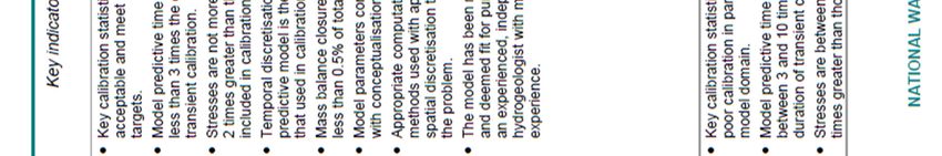
Comments for Namoi Water on Vickery Extension Project EIS Groundwater Assessment
1.0 Introduction and Scope of Works
Department of Planning is currently exhibiting Whitehaven Pty Ltd’s Environmental Impact Statement (EIS) for the
Vickery Extension Project (the Project) for public consultation.
Namoi Water has asked for my opinion on the Groundwater Assessment by NPM Technical Pty Ltd (trading as
HydroSimulations) (HS). This involved reviewing the following documents:
Vickery Extension Project Environmental Impact Statement - Appendix A Groundwater Assessment (Parts 1
& 2) (NPM Technical Pty Ltd t/a HydroSimulations, Report No. HS2018g, August 2018)
Vickery Extension Project Environmental Impact Statement - Appendix M Geochemistry Assessment (Geo-
Environmental Management, April 2018)
Vickery Extension Project Environmental Impact Statement – Attachment 4 Peer Review Letters (2018)
Vickery Extension Project Environmental Impact Statement – Attachment 6 Aquifer Interference Policy
Considerations and Water Licensing Addendum (2018)
The following documents were also read for background information:
Letter reports responses from State and Federal Government to EPBC Referral (2016)
Department of the Environment’s Statement of Reasons for a Decision on Controlled Action Under the EPBC
1999 (2016)
Vickery Extension Project Environmental Impact Statement - Appendix A Groundwater Assessment (Heritage
Computing Pty Ltd, Report No. HC2012/15, January 2013)
Briefing Paper for the Vickery Coal Mine – Jon-Maree Baker, EO, Namoi Water
The following sections provide comment on HydroSimulations (HS) Groundwater Assessment (2018) which included
a groundwater model, water balance and model predictions. I will cite their report as HS GA (2018). My comments
refer to figures from the HS GA (2018) report and should be read in conjunction with those reports unless I have
altered or annotated the figures in which case I have included them here.
2.0 Background and Previous Studies
Figure 1 shows the location of the Vickery Extension Mine (the Project) and the proposed water supply borefield
consisting of 10 bores (Figure 1 is annotated by GSI). The location of the mine within Upper Namoi Zone 4 and the
mine layout is presented in Figures 1 and 2 of HS GA (2018).
The Project includes the approved Vickery Coal Project (the Approved Mine), and is owned by Whitehaven Coal
Limited (Whitehaven). The Approved Mine includes the former Vickery Coal Mine (1986-1998) and the former
Canyon Coal Mine (ceased in 2009). Both these mines have been rehabilitated following closure. Whitehaven also
operates the Tarrawonga and Rocglen Coal Mines located approximately 10km to the north and 5km to the east,
respectively. All the coal mines access the Maules Creek Formation coal seams.
Whitehaven contracted HS to prepare a Groundwater Assessment which forms part of the Environmental Impact
Statement (EIS). The objective of HS GA (2018) was to provide an assessment of potential impacts to groundwater
associated with the Project, in line with the NSW Department of Planning and Environment (DP&E) Secretary’s
Environmental Assessment Requirements (SEARS) for the Project (Appendix 1).
HS GA (2018) includes the cumulative effects of operating all mines including the Project, Tarrawonga and Rocglen
Coal Mines between 2018 and 2044; including pumping 600 ML/year from all 10 bores planned to be installed in the
Gunnedah Formation of the Upper Namoi Alluvium, Layer 2 of the HS GA model (pumping at a combined rate of 1.64
ML/day).
Page 2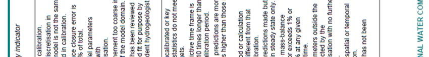
Comments for Namoi Water on Vickery Extension Project EIS Groundwater Assessment
Section 2.1 of HS GA (2018) presents an overview of previous groundwater assessments and monitoring programs.
There have been a number of water quality and groundwater level assessments undertaken since the early to mid-
1980s which has produced a reasonably representative dataset for the formation of the hydrogeological conceptual
model of the Project area. However, little monitoring data exists for the area to the north of the Project in the
Driggle Draggle Creek area and associated alluvium. In addition, while there have been many investigations in the
Project area, Whitehaven have never undertaken any surface water studies of flow in the onsite drainage areas and
the impact they have on recharging the adjacent Namoi Alluvial aquifers.
The DOI Water has a comprehensive groundwater monitoring network for the Namoi Alluvial aquifer to the west and
south of the Project site, but not in the north. Hydrographic data from these bores allow the HS GA (2018) model to
be calibrated for transient state conditions allowing the model to be more robust and enable groundwater level
predictions to be made in the Namoi Alluvial aquifers in the west and south of the Project area.
A groundwater monitoring bore network was established for the Upper Namoi Alluvium and Maules Creek
Formation in the Vickery South area in 2011/2012. These are discussed in Section 2.1 HS GA (2018).
A groundwater assessment for the Approved Mine was conducted by Heritage Computing (now part of HS) in 2012
and this provides the basis for HS Groundwater Assessment (2018). Whitehaven contracted Exploration Services Pty
Ltd to carry out a Groundwater Investigation Program to the immediate south of the Approved Mine area. This
include downhole geophysical logging, a transient electromagnetic (TEM) survey (Groundwater Imaging Ltd) and a
pumping test at a new bore. Please refer to Section 2.1 and Figure 16 in HS GA (2018) for further details on all the
monitoring bores used by HS in their Groundwater Assessment (2018).
As part of the HS GA (2018) the following was undertaken:
Review of groundwater and surface water monitoring data.
Revision of the groundwater conceptual model developed for the Approved Mine to account for changes in
the mine plan for the Project.
Revision of the Approved Mine groundwater numerical model, and conversion from MODFLOW-SURFACT
with an irregular cell mesh, to MODFLOW-USG with a regular cell mesh.
Recalibration of the impact assessment groundwater model.
Predictive modelling and sensitivity and uncertainty analysis.
Impact assessment and reporting.
HS GA relied on the following two reports in developing their conceptual groundwater model and numerical model
inputs:
Alluvial Drilling Report (ENRS, 2016) Vickery Extension Project Appendix A Groundwater Assessment:
Appendix A
Geochemistry Assessment of Overburden, Interburden and Coal Rejects (G.E.M., April 2018) Vickery
Extension Project Environmental Impact Assessment Appendix M Geochemistry Assessment.
HS GA (2018) was Peer Reviewed by Dr Frans Kalf of Kalf and Associates Pty Ltd. I will provide comments on Dr Kalf’s
Peer Review as part of this report.
Page 3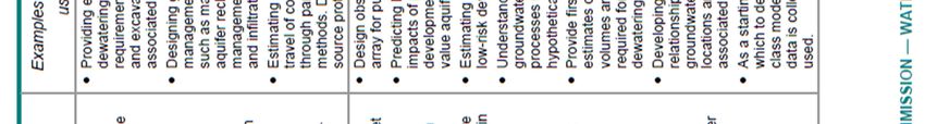
Comments for Namoi Water on Vickery Extension Project EIS Groundwater Assessment

                                                                                   Page 4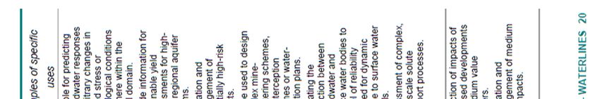
Comments for Namoi Water on Vickery Extension Project EIS Groundwater Assessment
3.0 Conceptual Hydrogeological Model and Data Input
3.1 Overview
HS GA (2018) included the following datasets as inputs into the conceptual model. I have provided brief comments
below:
Rainfall and Evaporation: Boggabri Post Office and Boggabri (Retreat) have records since the late 1880s;
Keepit Dam (from 1955); a meteorological station was installed at the Project site in 2013. Good data has
been collected but HS has assumed a long term average for the data up until 2015 (please refer to Section
2.2, Figure 3 and Table 1 in HS GA 2018) and applied it as a constant for modelling purposes. I believe this is
naïve.
Topography and Drainage: The model has good data coverage. Please refer to Section 2.3 and Figure 4 HS
GA 2018).
Geology: A comprehensive discussion is given in Section 2.5 HS GA 2018.
Maules Creek Formation: good data coverage; excellent data quality; excellent discussion on stratigraphy
and lithology, although down played the complexity and possible role of overburden and interburden layers;
good structural data; little discussion on the role of faulting planes exposed in the Project active pit walls and
how this may affect long term seepage.
Namoi Alluvium: good data coverage for southern and western adjacent areas; poor data for the northern
area including Driggle Draggle Creek alluvium. Modelled alluvium thickness is given in Figure 10 HS GA
(2018). HS has re-defined the alluvium boundary between the Project and the closest reach of the Namoi
River, which I agree with (please refer to Figures 11, 12 and 18 in HS GA (2018)).
Colluvium: some data collected for western area adjacent to the Project area (Figure 12 in HS GA 2018). Not
well understood for the remainder of the Project site.
Overall there is enough geological data, and understanding of relationship between the geological layers to
develop the conceptual groundwater model and to set up the numerical model layers. I do have concerns as
to why HS did not present any discussion on the possibility of the Karu and Woodlands Faults acting as
groundwater conduits allowing seepage into the pit via the exposed Project mine pit walls. I also would have
liked to have read more in the HS GA (2018) document on the role of the underlying Boggabri Volcanics
fractured rock aquifer in the groundwater conceptual model other than it is considered to be basement. This
infers that the Boggabri Volcanics underlying the Maules Creek Formation has a no flow boundary condition.
Clearly HS believe some through flow is expected to occur to the upper Maules Creek Formation as they
have included this in Figure 33 Conceptual Groundwater Model in HS GA (2018) for the western area.
However, for some unknown reason HS do not believe this flow exists below the Project emplacement area
to the west or under the mine void.
Hydraulic Data: Overall the hydraulic data is limited for all model layers but HS still considered the dataset to
be a ‘suitable basis for the development of a regional numerical groundwater model’ (HS GA, 2018).
Maules Creek Formation: moderately good spatially for the coal measures and insitu interburden and
overburden; no storativity or leakage data determined from the slug tests, etc.
Namoi Alluvium: good spatial and temporal data for the adjacent areas to the south and west of the Project
area; limited for the alluvial areas to the north of the Project area.
Colluvium: poor dataset spatially. Figure 12 indicates that HS discovered the water table to be deeper than
the thickness of the colluvium and given the high clay content HS does not seem to believe the colluvium is a
major component of transmitting groundwater throughflow from the exposed and weathered regolith of the
Permian Maules Creek Formation to the Namoi Alluvium and adjacent creeks and Namoi River. Please refer
to Section 3.1 and Tables 7 and 8 in HS GA (2018). However the underlying highly weathered conglomerate
Page 5
Comments for Namoi Water on Vickery Extension Project EIS Groundwater Assessment
in the Upper Maules Creek Formation could allow groundwater throughflow as evidenced in the borelogs in
HS GA, Appendix A (2018).
Land Use: Good understanding and data coverage. Please refer to Section 2.4 HS GA 2018.
Groundwater Users: HS discuss groundwater users in Section 2.6 in HS GA 2018. The data used for the
conceptual model water balance is of moderate quality as HS couldn’t access data from 2010 onwards so
assumed constant average groundwater abstraction from 2010 which provides uncertainty into the
groundwater model.
Groundwater Dependent Ecosystems: HS discusses GDEs in Section 2.8 and basically say there isn’t any.
Groundwater Monitoring and Baseline Dataset: There are considerable amounts of data presented from
studies carried out since 1986. The most relevant to this EIS is from Canyon and Vickery Mines, although the
model also needs to take into account cumulative effects from Tarrawonga and Rocglen.
The monitoring bores are presented in Figure 16 in HS GA 2018. Please refer to Section 2.9, 2.10 and 2.11 for
an in-depth discussion on water quality and water level data. Good spatial and temporal groundwater level
and water quality datasets were obtained from DOI Water Namoi Alluvial monitoring bores to the south and
west of the Project area, but absent to the north of the Project area. Good spatial and temporal
groundwater level and quality dataset for the Maules Creek Formation were collected within the Project
area. A robust discussion was given by HS on water level trends as a result of mine dewatering and rainfall.
Water quality was well discussed with respects to identifying groundwater types and environments. Even
though there was good discussion on groundwater evolution in terms of major ion chemistry and salinity,
there was little discussion on groundwater mixing and the use of isotope analysis to help determine and
quantify groundwater flow components in the groundwater model. Trace metals were discussed and HS
identified some metals were elevated above ANZECC (2000) Freshwater 95% protection. This is mostly due
to the natural chemistry and low transmissivity of the Maules Creek Formation but it highlights the need to
ensure this groundwater does not end up in the Namoi Alluvium, Namoi River and creeks. I have noted that
groundwater samples collected from monitoring bores located between the Canyon Coal Mine and Driggle
Draggle Creek are high in EC and pH. Temporal changes in groundwater quality, specifically EC and pH for
monitoring sites in the Canyon, Rocglen and Tarrawonga Coal Mines were discussed in Section 2.11.5
Regional Mine Inflow Data: HS discusses Rocglen and Tarrawonga Coal Mine inflow data from the Maules
Creek Formation. They conducted regional numerical groundwater modelling as part of the assessment for
the Tarrawonga Coal Project in 2011. HS has based their inflow model on their earlier groundwater model
for the Approved Mine in 2012 and has used it as a basis for developing the mine inflow for the 2018
modelling of the Project area. For further discussion please refer to Section 2.12 of HS GA 2018.
3.1 Hydrogeological Setting
HS undertook a thorough overview of previous groundwater assessments and monitoring programs. A Groundwater
Assessment was undertaken by Heritage Computing (now HS) in 2012, which is still the basis for HS Groundwater
Assessment (2018) report. The previous investigations and HS 2018 review state there are two groundwater systems
operating in the Project area:
Unconsolidated alluvial aquifer of the Namoi River including the shallow Narrabri Formation and the deeper
Gunnedah Formation which includes productive paleochannel alluvial deposits.
Permian Maules Creek Formation which includes porous rock aquifers including multiple water-bearing,
fractured coal seams and interburden/overburden deposits.
Figure 33 presents the Conceptual Groundwater Model pre-mining and towards the end of mining (in HS GA 2018).
However, there is a third groundwater system, the Permian porous and fractured rock aquifer of the Boggabri
Volcanics. HS has not considered this aquifer in any detail. This groundwater system will underlie areas of the
Page 6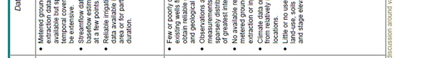
Comments for Namoi Water on Vickery Extension Project EIS Groundwater Assessment

bottom of the mine void quite closely by the end of the active mining phase. HS consider the Boggabri Volcanics to
be basement rock.

The Project is located within the topographically higher exposed areas of the Maules Creek Formation immediately
west of the Vickery State Forest (Figures 4 and 5 in HS GA 2018). The mine area is surrounded by the Namoi Alluvium
(Upper Namoi Zone 4) to the south, west and north (Figures 1 and 8 in HS GA 2018). Figure 9 in HS GA 2018 presents
cross sections clearly showing the relationship between the final pit walls and the exposed coal seams where
groundwater will seep into the final pit void. The cross section also shows the base of the weathered layer within the
Maules Creek Formation near the ground surface; the basement Boggabri Volcanics; and the Karu and Woodlands
Faults.

The Project’s active mine is located solely within the Maules Creek Formation. HS has thought about connectivity
between geological units to the west of the mine’s waste rock emplacement area, where the closest reach of the
Namoi River is within 500m of the Project. HS relied on a report commissioned by Whitehaven to undertake a drilling
investigation to determine the extent and nature of unconsolidated alluvial and colluvial deposits within the Vickery
Extension Project (ENRS Pty Ltd, 2016). Based on this work HS has concluded that there will be no direct drawdown
effect on the Namoi Alluvial aquifers as a result of the active mine. HS do say they believe there will be indirect
drawdown effects as a result of dewatering in the Maules Creek Formation which will induce insignificant flow from
the overlying alluvium.

The location of the investigation bores is given in Figure 6. ENRS successfully used the geological logs to ‘ground
truth’ the TEM survey undertaken in December 2015 by Ground Water Imaging Pty Ltd and interpreted by Dr David
Allen as shown in Figure 7 in HS GA 2018 (please refer to ENRS report for details). ENRS undertook detailed
geological logging of all boreholes, geophysical logs and water quality from samples taken from the monitoring
boreholes. I agree with the re-defined Namoi Alluvium boundary to the west of the Project area (the closest reach of
the Namoi River) which is presented in Figure 8 in HS GA 2018.

However, contrary to HS I believe there is a direct drawdown effect on the Namoi Alluvium as I believe there is a
groundwater flow component through the unconsolidated material that spans between the Maules Creek Formation
in the Project area and the Namoi Alluvium. The degree of hydraulic connectivity between these deposits will
determine how great an effect there will be on drawdown in the Namoi Alluvial aquifers (especially the shallow
Narrabri Formation). The sediment that spans between the Maules Creek Formation and the Namoi Alluvium
consists of the clayey regolith and gravelly clay colluvium. The former is a layer of unconsolidated solid material
covering the Maules Creek Formation formed from weathering and the latter are the deposits of the weathered
Maules Creek Formation, or regolith, which has been deposited on the lower slopes of the Project area outside the
active mine void. This information is important for the conceptual groundwater model as it will determine how great
the effects of removing the Maules Creek Formation in the active mine area will affect rainfall recharge to the
colluvium, the Namoi Alluvium, the Namoi River and Driggle Draggle Creek.

No comment is made by HS as to the possible role of the exposed Kura and Woodlands faultlines in the pit and final
void wall to conducting groundwater seepage into the mine pit and final void.

The following sections discuss the hydrogeological setting and whether the data was temporally and spatially
representative.

Figure 4 in HS GA 2018 shows the surface water drainage in the Project area. Namoi River is located to the west;
Driggle Draggle Creek is located to the north and South Creek is located to the south of the Project area. Three
drainage lines have been identified within the Project area – North Drainage Line (which is an upper reach of Driggle
Draggle Creek), North-west Drainage Line (which is almost solely within the Project area), and West Drainage Line.
HS report states that the North Drainage and West Drainage Lines will be bunded/diverted away from the active

                                                                                                               Page 7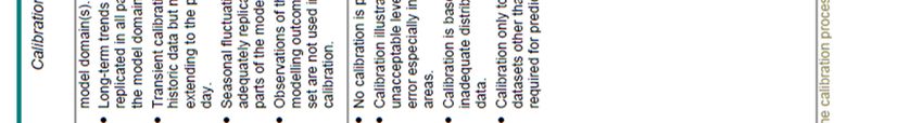
Comments for Namoi Water on Vickery Extension Project EIS Groundwater Assessment

mine pit area. The North-west Drainage Line will be completely removed. The Project Extension area, which includes
water storage ponds for seepage from the mine void, comes within 500m of the Namoi River.

HS discusses rainfall and evaporation data and trends in the Project area. Rainfall is the main source of groundwater
recharge to the Project area. HS have assumed a long term average for modelling which I believe is naïve.

HS stated there were only pumping records up to 2010, as they (or the public) couldn’t access data since. Therefore
HS assumed from 2010 that average pumping from the Upper Namoi Alluvium groundwater system continued at a
constant rate. I believe this is unsatisfactory and introduces more uncertainty into the groundwater model.

4.0 Numerical Groundwater Model Setup
4.1 Appropriateness of Numerical Model Package and Confidence Level
HS don’t say why they converted from MODFLOW-SURFACT with an irregular cell mesh, to MODFLOW-USG Beta
with a regular cell mesh. I understand the latest model MODFLOW-USG has a more powerful modelling package
which allows better re-wetting of ephemeral streams, evolution of drainage from waste rock emplacement, drainage
from the mine pit and the mine void.

HS GA 2018 state they believe the model has a confidence Level of Class 2 to Class 3 (medium to high confidence).
Please refer to Table 2-1 in Appendix 1. This is largely to do with the model inputs, calibration and verification status.
I agree with this confidence level. However, the Australian Groundwater Modelling Guidelines (Barnet et al., 2012)
does not seem to allow for sensitivity and uncertainty analysis in determining the confidence level. This groundwater
model has not had a robust PEST-type sensitivity analysis carried out on the model parameters. HS did find during
the calibration process that the model was very sensitive to changes in vertical and horizontal hydraulic conductivity
of the model layers. A high-level assessment of model uncertainty was conducted by HS to analyse the effect of
vertical hydraulic conductivity on predicted pit inflows. These were increased and decreased by an order of
magnitude (multiplied by 10 and divided by 10, respectively) which resulted in an estimate of pit inflows of -8% an
+16%. HS considered these model results to indicate negligible uncertainty. I believe this is unsatisfactory for this
groundwater model which has been developed to predict the effects of groundwater level drawdown as a basis for
Whitehaven’s EIS. A robust sensitivity and uncertainty analysis is considered to be essential in the determination of
whether the model is sensible and realistic.

Barnett et al (2012) stated in the Australian Groundwater Modelling Guidelines that:

‘Care should be taken to choose increments in parameters that are sensible. It is not uncommon to vary hydraulic
conductivity by an order of magnitude (a factor of 10), but each parameter should only be adjusted by an amount
commensurate with its likely range.

During automated model calibration, the search algorithm computes sensitivities of the objective function to
changes in all parameters and uses them to guide the search. When the best estimates are found, these sensitivities
are used to estimate the uncertainty in the best estimates. This type of sensitivity can be examined using PEST and
similar software to gain insights into the calibration process.’

4.2 Model Extent, Layers and Geometry
HS stated in Section 4.2 in HS GA 2018 that the Tarrawonga Coal Mine regional numerical groundwater model
(Heritage Computing, 2011) demonstrated that drawdown influence from the Tarrawonga, Maules Creek and
Boggabri Mines would not reach the Vickery Coal Mine. They surmised therefore the Project mining effects would
not propagate to the Tarrawonga Coal Mine and therefore focused the development of their model on the Vickery
Coal Mine for assessing the environmental effects of the Approved Mine.

                                                                                                                  Page 8
Comments for Namoi Water on Vickery Extension Project EIS Groundwater Assessment

I believe the model layers are relevant, and are not overly simplified or too complex. The model extent incorporates
sufficient relevant Zone 4 and Zone 2 groundwater sources in the WSP for the Upper and Lower Namoi Groundwater
Sources 2003; significant agricultural extraction from bores accessing the Upper Namoi Alluvium; and the adjacent
coal mines of Tarrawonga to the north and Rocglen to the east.

HS developed 14 model layers including:

Layers 1 and 2: Narrabri and Gunnedah alluvial formations, regolith or overburden (the alluvium is consistent with
the DPI Water groundwater model for the Upper Namoi Alluvium).

Layers 1 to 12: represent the multiple layers of coal seams and interburden and in recognition of vertical hydraulic
gradients. Layers 10 and 12 are the targeted

Layer 13: Underburden.

Layer 14: Basement Boggabri Volcanics.

HS GA 2018 should have included a cross section showing how the 14 layers, including the ‘dummy’ layers, related to
each other.

4.3 Model Stresses and Boundary Conditions
Please refer to Section 4.6 and Figure 35 in HS GA 2018 for a full description of the model stresses and boundary
conditions. The boundary conditions are sensible. The river bed conductance values applied are reasonable. The
equivalent leakage coefficients decrease in order of magnitude from Namoi River to Driggle Draggle and to other
creeks, which is an acceptable approach when there is little river bed conductance data for the smaller creeks. The
ephemeral creeks are able to re-wet. The Namoi River and Driggle Draggle Creek are able to become gain or lose
water along the reaches modelled.

HS do not discuss how the rainfall recharge cells around the contact between the Namoi Alluvium and the Maules
Creek Formation were determined. I believe they have used this as a proxy for rainfall recharge into the exposed
Maules Creek Formation which then recharges the colluvium and Namoi Alluvium via runoff and throughflow.

The model stresses are based on constant average values for the initial steady state calibration and prediction
phases. There could be a reasonable error in assuming constant average values but that is the reason why a robust
uncertainty analysis should have been undertaken.

4.4 Numerical Groundwater Model Calibration, Verification and Sensitivity Analysis.
Initial Steady State (pre-mining and pre-pumping) calibration was undertaken using derived ‘initial groundwater
levels’ contour plots of groundwater levels and hydrographs from DOI Water Namoi Alluvial aquifer monitoring
bores and data collected from monitoring bores from the Project area. The effects of pumping and mining were
modelled out. HS achieved good initial steady state calibration for the Project area by replicating regional
groundwater levels in the Upper Namoi Alluvium. The initial calibration and water balance is discussed in detail in
Section 4.8 in HS GA 2018.

Transient State Calibration was achieved moderately well for the Project area based on monthly stress periods from
2006 to 2011. The fit between the Model versus Measured hydrographs was best in the Vickery Project area, not so
much for the other mines within the model area. This is discussed in detail along with Transient Water Balance in
Section 4.9 in HS GA 2018.

Verification of the groundwater model was achieved using six monthly stress periods from 2012 to 2017. This and
the Verification Water Balance is discussed in detail in Section 4.10 in HS GA 2018.

                                                                                                             Page 9
Comments for Namoi Water on Vickery Extension Project EIS Groundwater Assessment
Transient prediction and recovery simulations were undertaken, including for cumulative effects of the Project,
Rocglen and Tarrawonga Coal Mines operating at the same time. These are discussed in Section 4.7 in HS GA 2018.
Figure 37 in HS GA 2018 summarises the stress period setup in the model; sequencing of open cut operations, waste
rock emplacement and timing of establishing the final void.
The Sensitivity Analysis is discussed in Section 4.8, 4.9 and 4.11 in HS GA 2018. They undertook a manual (trial and
error) calibration and verification where they state the following:
‘...the groundwater model was calibrated by varying a large number of parameters related to rock mass permeability
and storage to match groundwater level and mine inflow time-series data. The model run time (10+ hours)
precluded a full PEST-based sensitivity analysis. However, information on parameter sensitivities was obtained
through observations during the calibration process. The most sensitive parameters with respect to calibration of
measured groundwater levels and mine inflows were found to be:
Vertical hydraulic conductivity of the coal measures (Kv).
Horizontal hydraulic conductivity of the coal measures (Kh).
Specific yield in the alluvium (for transient calibration of hydrographs).’
However in the Australian Groundwater Modelling Guidelines Barnett et al (2012) state:
‘During trial-and-error calibration, sensitivity analysis involves changing a model parameter by a small amount to
establish how model predictions are affected by that change. Manual sensitivity analysis requires changing a single
model parameter, re-running the model to obtain a new set of predicted heads and fluxes and observing the effect
of the change, either by eye or numerically by differencing. In this context, a true sensitivity (derivative) is never
calculated. The emphasis is on determining how sensitive the model is to each parameter, using a non-technical
interpretation of 'sensitive'’.
Dr Kalf in his peer review (Attachment 4 in Whitehaven’s EIS) noted ‘it would have been possible to reduce this cell
mesh count considerably given that it had already been established that there would be no drawdown influence by
the Extension or the ‘Approved Mine’ at the Tarrawonga mine and vice versa’.
When the best estimates are found, these sensitivities are used to estimate the uncertainty in the best estimates.
This type of sensitivity can be examined using PEST and similar software to gain insights into the calibration process
(Barnett et al., 2012). However HS stated the model run times precluded a full PEST-based sensitivity analysis. I
believe this is inappropriate given today’s ability to ‘hire’ large computers in the cloud to undertake these large data
analyses.
5.0 Model Results
5.1 Introduction
HS stated ‘the transient prediction simulation was operated in two different modes:
1. Baseline scenario – Rocglen and Tarrawonga Coal Mines operating without the Project.
2. Cumulative scenario – the Project, Rocglen and Tarrawonga Coal Mines operating at the same time.
In Section 5.1 HS discussed the Mining Schedule for the Project, Tarrawonga and Rocglen Coal Mines. The hydraulic
properties from the model transient calibration were run from January 2018 until December 2044. The Project
commenced in 2020 and finished in December 2044. The only time-varying stress in the prediction was the mining.
All other stresses, namely, rainfall (constant long-term average rates), average river levels and average irrigation
pumping rates (July 2009-June 2010) were assumed to be constant. The water balance was also averaged over the
25 years. The predicted groundwater inflow into the Project mine pit is shown in Figure 49 and Table 21 in HS GA
Page 10Comments for Namoi Water on Vickery Extension Project EIS Groundwater Assessment
2018. HS state the porous rock groundwater within the coal measures of the Maules Creek Formation is the only
groundwater source for pit inflows. I am not convinced of this as little regard has been given to:
the underlying fractured Boggabri Volcanics
the possibility of leakage through diverted/bunded onsite drainage systems
exposed fault planes in the mine pit walls
5.2 Predicted drawdown of Groundwater Levels
HS discusses the predicted drawdown of groundwater levels in Section 5.4 in HS GA 2018. HS concludes the
predicted 1m groundwater drawdown contour stays entirely within the Maules Creek Formation and does not
impinge on the Upper Namoi Alluvium. However, given the model is highly sensitive to the hydraulic properties of
the model layers, and no robust uncertainty analysis has been undertaken, I am not convinced the 1m drawdown
contour presented in Figures 50 and 51, and in Appendix E in HS GA 2018 is realistic.
5.3 Predicted groundwater flow
HS stated in Section 5.3 that ‘up to the end of mining there would be a continuous loss of water from the
groundwater system to the mining void’ of between 0.01 and 1.42 ML/day. The groundwater source would be from
the ‘porous’ rock (matrix and fracture porosity, that is, dual porosity) within the coal measures of the Maules Creek
Formation, and that was the only source. HS state that ‘after the end of mining there would be long-term
groundwater inflow from these coal bearing rocks, including the Project waste rock emplacements, with no direct
contribution of groundwater from the Upper Namoi Alluvium’ (bold emphasis placed by this writer). HS stated in
Section 5.5.2 that ‘there could be incidental loss through enhanced leakage from the bordering alluvium to the
underlying Maules Creek Formation’. This increase in flux from the alluvium to the Maules Creek Formation was
investigated by HS for Zone 4. ‘The average increase in total flux of about 0.1 ML/d is predicted from 2073 to 2094
post-mining. The drawdown from the Project will continue to extend post-mining due to the low permeability of the
Maules Creek Formation. This will result in an increasing flux from the alluvium to the hard rock, post-mining.’
HS discussed there was potential for groundwater seepage from the Western Emplacement to an underlying thin
alluvium embayment to the north-west of the open cut. HS estimated during the mining operation the average
groundwater seepage to the alluvium is 0.013 ML/d for the cumulative scenario. The average flow increased to 0.032
ML/d during the initial 20 years of recovery, before reaching a long-term equilibrium flow of 0.022 ML/d from the
emplacement to the alluvium (please refer to Table 19 in HS GA 2018). HS state the long-term flow is restricted by
the residual final void, which operates as a strong sink.
The main concern is the quality of the groundwater seepage and whether there will be any environmental effects to
any bores capturing recharge from this part of the Zone 4 catchment.
The Project will irreversibly change the groundwater flow direction from westwards to eastwards. Any recharge that
would have occurred in the future, from rainfall runoff or groundwater throughflow from the Maules Creek
Formation, in the Project mine void area will not recharge the Upper Namoi Alluvium, the Namoi River and Driggle
Draggle Creek. In fact it will induce flow from the Namoi River to the alluvium with the change in hydraulic gradient
with the depressurisation of the Maules Creek Formation (and removal of most of the Formation in the Project area)
and the mine void which will act as a strong sink.
If the mine void is a strong sink where will this groundwater flow to given HS believe the underlying Boggabri
Volcanics is more or less a no flow boundary?
5.4 Predicted baseflow changes
HS state in Section 5.6 that there will be a possible increase in leakage of about 0.0002 ML/ay for the cumulative
mining scenario from the 4km reach of the Namoi River. They consider this to be insignificant compared to ‘normal
Page 11Comments for Namoi Water on Vickery Extension Project EIS Groundwater Assessment river flow’. The Namoi River is a losing river along this stretch and so this leakage could prove to impact the Namoi River during drought periods, affecting GDEs down gradient. Likewise, Driggle Draggle Creek will also experience ‘insignificant’ leakage of about 0.001 ML/day (cumulative mining scenario) from the creek to the underling alluvium due to the indirect effects of depressurising the Maules Creek Formation. HS state that Driggle Draggle Creek is also a losing stream with a constant baseflow discharge of about 0.026 ML/day. These flow loses may seem ‘insignificant’ during ‘normal’ flow periods but this modelling has not taken climate change into consideration where long and more intense droughts are predicted. 5.5 Blue Vale Void Water Storage impact on Namoi River HS discuss this in detail in Section 5.7 in HS GA 2018. HS stated that during the period of mining, water storage in the void would mitigate the effects of mining which would otherwise cause the predicted insignificant Namoi River leakage. The outflow from the void to the Namoi River is expected to be around 0.015 ML/day. This may or may not be the case depending on the sensitivity of the vertical and horizontal hydraulic conductivities of the model layers. Water quality from leakage from the Blue Vale Void is not expected to impact the 4km stretch of the Namoi River. HS computed the mass of dissolved solids that could migrate from the water storage and distributed across the 10 model layers would be about 38 kg/day (about 14 t/year). I agree with HS that the baseflow to the Namoi River will occur in the upper few layers of the model. The hydraulic gradient beneath the river is downwards to the deeper layers. Therefore the risk to the Namoi River will only be in the top two layers of the model (alluvium, colluvium/regolith). HS presented computations of salt load on the Namoi River in Section 5.7.2 based on median flows at the Boggabri gauging station and a worst case scenario for salt load the increase in salinity would be approximately 0.007%. This is less than the NSW Aquifer Interference Policy requirement of ‘No increase of more than 1% per activity in long-term average salinity in highly connected surface water source at the nearest point to the activity’. I would be interested in seeing how this might change after a robust Uncertainty Analysis is carried out so that optimal hydraulic parameters are used in the HS model groundwater flow predictions. 6.0 Climate Change and Model Uncertainty Please refer to Section 7.1 in HS GA 2018 for HS discussion on Climate Change. HS conducted one single transient predictive simulation for rainfall recharge, altered according to the drier of the predictions. There was found to be
Comments for Namoi Water on Vickery Extension Project EIS Groundwater Assessment
7.0 Impacts on the Groundwater Resource
HS provide a potential impact assessment on groundwater, surface water bodies and Matters of National
Environmental Significance in Sections 6.1, 6.2 and 6.3 in HS GA 2018.
HS have concluded as a result of modelled cumulative effects from the operation of the three Whitehaven coal
mines:
There will be an increase in hydraulic conductivities for waste rock emplaced in the Western Emplacement.
A void acting as a sink permanently changing the groundwater flow direction from westerly to easterly
towards the void as shown in Figure 60 in HS GA 2018. The final equilibrium groundwater levels are
expected to be 100m lower than the current groundwater levels near the void.
The final void water quality is expected to have a median EC of 4,200 microSiemens/cm and salinities of
about 2,600 mg/L.
There will be induced, but insignificant, water losses from connected water sources: Upper Namoi Alluvium
Zone 4 and Namoi River (please refer to Table 21 HS GA 2018).
There will be no adverse water quality impacts from the Western Emplacement into the alluvium
embayment (not greater than is currently naturally occurring). Please refer to Table 20 in HS GA 2018.
There will be no adverse water quality impacts from the overburden and interburden materials from the
proposed open cut as these are mostly expected to be non-acid forming (please refer to GEM (2018)
Appendix M of the Vickery Extension Project EIS). Some material close to the coal seams are potentially acid
forming and management measures including co-disposal with non-acid forming material will allow for an
overall non-acid forming material.
There will be less than 0.2m drawdown experienced in privately owned bore except for bore RB1 (0.61m)
located to the east of the Vickery State Forest, near the Rocglen Coal Mine. Please refer to Table 22 and
Figure 15 for bore locations.
There are no outstanding GDEs in the area.
There will be no adverse impact on Matters of National Environmental Importance.
All the above conclusions are based on a groundwater model that has not had a robust PEST-type Sensitivity Analysis
undertaken on the model hydraulic parameters, even though the model has been found (‘manually’) to be highly
sensitive to small changes in hydraulic conductivity in all model layers. No robust Uncertainty Analysis has been
undertaken to determine the effect this has on the model predictions.
A discussion was also presented on the proposed Water Supply Borefield which is to include ten bores located within
the Gunnedah Formation and located to the north of the Project area between Driggle Draggle Creek and Bollol
Creek. This seems like an afterthought, as HS has stated the groundwater model was developed and calibrated for
the Vickery Project mine area, and that there are no DOI Water Namoi Alluvial monitoring bores to calibrate the
groundwater model in the borefield area. I do not place a lot of confidence in the predicted cumulative groundwater
level drawdown predictions for the Namoi Alluvium.
8.0 Management and Mitigation Measures
8.1 Groundwater and Surface Water Licensing
HS presented Table 25 below which summarises Attachment 6 of the EIS:
Page 13Comments for Namoi Water on Vickery Extension Project EIS Groundwater Assessment
The Project has enough licenses to account for groundwater usage during the mining and post-mining phase of the
project, if Figure 49 below is accurate. This is assuming the model hydraulic conductivities for the coal seams and
alluvium are representative. The hydraulic conductivities used in the modelling will affect the computed
seepage/inflows from the coal seams into the mine pit and the induced drawdown in the alluvium into the porous
rock which will ultimately end up flowing into the mine pit. A full PEST sensitivity and a Monte Carlo uncertainty
analysis would have investigated whether the modelled inflows are realistic.
Page 14Comments for Namoi Water on Vickery Extension Project EIS Groundwater Assessment
8.2 Proposed Groundwater Monitoring Program
HS state in Section 8.4.1 that ‘the existing network is considered adequate for providing information on groundwater
flow and a basis for groundwater model calibration and verification and could be continued for the Project’. I
presume HS means all the monitoring locations shown in Figure 16 in HS GA 2018.
HS presented the proposed groundwater monitoring program in Table 26 in HS GA 2018.
I agree with HS that at least ‘two additional monitoring bores for water levels and quality should be installed in the
waste rock to validate the predicted level of groundwater mounding and to check on the water quality of the
leachate’.
I agree with HS that the results of the monitoring program for drawdown should be used to validate modelling
predictions every 5 years following Project commencement, as per the Australian Groundwater Modelling Guidelines
(Barnett et al, 2012).
9.0 Conclusions
I believe the conceptual hydrogeological model is based on good data and model inputs, with the exception of the
lack of discussions on the fault traces and fractured Boggabri Volcanics role in groundwater seepage.
The numerical model is based on sound boundary conditions and model layers. It has been well calibrated for
transient conditions for the Vickery Project area only, using groundwater hydrographs between 2006 and 2011. HS
has verified the model based on 5 years of data (2012-2017). It is not well calibrated for predicting the effects of the
proposed water supply borefield.
Page 15Comments for Namoi Water on Vickery Extension Project EIS Groundwater Assessment
I am concerned that the model is based on constant long term averages for rainfall and evaporation; constant
averaged river flows and constant irrigation pumping based on water usage for 2009-2010.
The model has not had a robust Sensitivity and Uncertainty analysis which could lead to different predictions of
groundwater drawdown impacts on other groundwater users. This should be undertaken before the Vickery
Extension Project goes ahead.
I believe HS needed to undertake more impact analysis for Driggle Draggle Creek as it feeds the Barber Lagoon and
associated GDEs. Monitoring bores located between the former Canyon mine and Driggle Draggle Creek indicate
there is poor groundwater quality. If Whitehaven do not effectively divert the stream flow around the eastern side of
the Project then this may lower water quality in the creeks lower reaches, and the Namoi Alluvial aquifers it
recharges to the north of the Vickery Extension Project.
Page 16Comments for Namoi Water on Vickery Extension Project EIS Groundwater Assessment
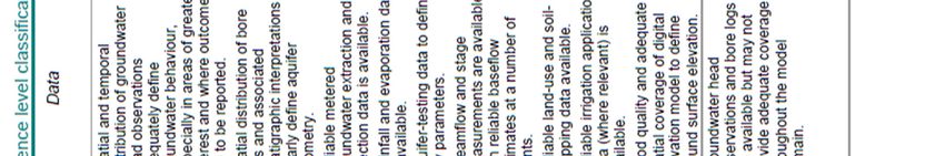
Appendix 1. Table 2-1: Model confidence level classification – characteristics and indicators (Australian
Groundwater Modelling Guidelines. Barnett et. al., 2012)
Page 17Comments for Namoi Water on Vickery Extension Project EIS Groundwater Assessment
Page 18Namoi Water
Submission to the Review of Environmental Impact Statement –
Whitehaven Pty Ltd - Vickery Coal Mine Extension
2018
Photo : Lake Keepit
Namoi Water : Supporting sustainable water use in the Namoi Catchment and representing water users in the
Peel, Upper and Lower Namoi Catchment Area
Executive Officer : Jon-Maree Baker
Web: www.namoiwate.com.au
NW submission to Review of Environmental Impact Statement Vickery Coal Mine ExtensionIntroduction
Namoi Water represents Water Access licence holders in the Namoi Catchment, we are a non-profit,
nonpolitical organization supporting our members to achieve a sustainable irrigation industry that meets
the environmental, economic and social needs of our local communities. Namoi Water represents 800
members these entitlement holders within the catchment vary in size from single employee operations
to businesses employing seventy employees. The crops grown range from grains and pulses, cotton,
vegetables, intensive animal production, Lucerne and niche market food crops. The direct contribution
to our economy is in excess of $800 million per annum. This is based on a secure supply of high quality
irrigation water both surface and groundwater.
Namoi Water has a breadth of experience in relation to Water reform and assessment of water resources
in relation to extractive industries impact. Water reform has occurred over the last two decades, the
Achieving sustainable groundwater entitlement program reduced groundwater entitlements by 50%
across the Upper and Lower Namoi. This submission is made based on Namoi Water’s current policy
positions that are ratified at the Annual General Meeting each year. However we note that members are
entitled to their individual views in relation to this project.
Namoi Catchment area Figure 1.
NW submission to Review of Environmental Impact Statement Vickery Coal Mine ExtensionIntroduction :
Namoi Water represents over 800 members within the Namoi Region, we are making this submission on
their behalf collectively. This submission does not preclude an individual member making a submission,
however we note our policy positions are endorsed by members annually and through the provision of
draft submission points to our members.
Namoi Water requests that if the Department of Planning and Environment (DoPE) is balancing input into
a project it clearly considers the weighting of submissions from groups such as Namoi Water who make a
technical submission collectively on behalf of many members.
We request clarification on the use of submission numbers to demonstrate social licence for a project.
If this project is using the number of submissions as one way of determining the level of community
support we ask that our submission is considered in terms of the number of members that we represent.
Further if this is not possible then we request the opportunity for our individual members to submit,
expressing their objection to the project proposal.
The first proposal for the Vickery coal mine (4.5 mt pa) came on the back of three other large projects and
was one of the first mines to go through the new Planning Assessment Commission process. In our view
as a project, it slipped under the radar. During the assessment and subsequently approval it is clear there
was not the level of scrutiny applied to the original Vickery project as others. We would not consider the
lack of interest and attention to the original project as a representation of anything other than that the
community had reached both saturation and fatigue in terms of engagement on mining project
assessment process at that time.
Recommendation :
On the basis of our review of the project, Namoi Water does not support the extension project and the
following technical comments are made regarding the proponent’s Environmental Impact Statement.
Key Issues;
Social Licence
- Clear process for the determination by the DoPE and the Independent Planning Commission (IPC)
regarding factors that indicate social licence.
Surface Water
- A full review of all Whitehaven projects and their water licences to ensure adequate licences are
held to cover projected water use under various climate scenarios.
- All volumes that are required to offset impacts from seepage of surface water are set aside or
surrendered to the NSW Government to ensure these licences are not used for consumptive
purposes.
- Further assessment on the impacts on the Boggabri Demonstration Reach for fish and riparian
habitat as a result of contamination/reduced water quality.
NW submission to Review of Environmental Impact Statement Vickery Coal Mine Extension- Impact of discharges from contaminated mine water, seepage, acid mine water is assessed on
worst case scenario and reassessed with additional modelling
- Impact on Driggle Draggle creek and Station Creek has not been fully assessed.
Ground Water
- Continued use of final voids against international best practice standards and Narrabri Shire
Council Policy and should not be allowed to continue
- PEST sensitivity analysis must be undertaken
- See technical document from Groundwater Solutions International (attached)
Infrastructure
- Proposed surface Infrastructure location and risk in relation to surface water contamination,
increasing the embankment, disturbance area, changes to noise, dust and other impacts
- Development of rail loop facilitates continued expansion of mining surrounding Boggabri
township and is a risk that should be fully assessed
Rail Link
- Lack of information in the EIS
- Impact on Namoi River and creek systems
- Floodplain redistribution, changed flow velocities, impact on neighboring properties not provided
in detail. Project cannot proceed without transparency of detail.
Agriculture
- Cumulative Agricultural impacts from mining footprint and purchase of surrounding farm land
due to incursive offsite effects of operations above predictions within EIS and should be assessed.
Planning process
- Transparency regarding the weighting of risk and issues within the planning process which is
designed to approve projects.
- The capacity of government agencies to review technical issues during restructure and significant
reform processes.
NW submission to Review of Environmental Impact Statement Vickery Coal Mine ExtensionSocial Licence
The community has learnt from firsthand experience over the last few years since the commencement of
mining at Maules Creek, that the capacity of PAC recommendations to be translated into consent
conditions to effectively mitigate impacts is lacking. Further, the adherence to consent conditions by the
proponent and the ability of the compliance agents to hold them to account resulted in suboptimal
outcomes for the community. The translation of recommendations from a genuine Planning Assessment
Commission (PAC) intent to proposed mitigation through the writing of consent conditions by the
Department is a major risk in projects such as this. The use of the words “reasonable”, “feasible”,
“facilitate” and “generally in accordance with” are abhorrent to the community. These words mean a
proponent to can simply attempt to meet a condition and this is seen as being a sufficient outcome to
meet the original mitigation proposed. The subsequent modifications of original conditions of approval
often result in small wording changes which change the entire effect and intent of the requirement. This
continual watering down continues to erode trust in both the planning process and Department.
In short there is little social licence for this proponent and consequently the project, outside those that
stand to benefit from some form of direct financial gain. Many of the supporters do not live in the local
area and are fly in fly out staff. We request the Department clarify the exact numbers of staff that live in
the region and how this is quantified – having a post office box does not qualify you as living in the region
and contributing to the community. The shift in support amongst the Boggabri community more generally
should be well heeded by the Department in the consideration of this project.
The questions to the Department at the information session in Boggabri, the social media videos with
local community members speaking out about the negative impacts, and the litany of failures by the
proponent to fulfil its current consent conditions and commitments in other projects all stand as evidence
that this extension is not in the best interest of the impacted community.
We note that many farmers have received survey calls from companies clearly working for Whitehaven
asking leading questions to gain either support or indifference of opinion to the project – this is not proper
quantitative/qualitative assessment to be used as evidence to support the proponent or their activities.
In the last few years we have undertaken a poll of main street businesses to ask about Whitehaven and
mining in general and its value to the community and in the majority, it is generally a negative view from
those downstream of the mine.
The relationship with councils is also skewed to the proponent given the VPA system. If all of the
agricultural sector was allowed to VPA our rates under one agreement we could negotiate a very different
outcome regarding what civil works and infrastructure was undertaken and determine where splash cash
went in the community as well. This would significantly change our relationship and power balance with
Council from price taker to price maker.
Mining has a long history of operation near Boggabri, undertaken in many cases by proponents who have
lived and operated locally. The Boggabri community has supported these mining operations as they were
in balance with the broader community and other industries.
NW submission to Review of Environmental Impact Statement Vickery Coal Mine ExtensionNamoi Water members have noted the responsiveness to community and neighbor relations were
generally well managed, historically. Our members are not anti-mining and have engaged in the process
with open minds regarding previous proposed developments. However this current project follows on
from many negative experiences of the Maules Creek project, often given as the prime example of the
failure of the planning system.
Unfortunately our experience to date is that Whitehaven have over-promised and under-delivered. An
example of this was the requirement to provide funds for Boggabri Medical Centre annually which was
only undertaken after community pressure, many years after the original promise.
The VPA’s presented in the project are somewhat tainted with the proponent’s own staff threatening the
Boggabri projects to be withdrawn if there was not community support for the EIS. This form of
intimidation has been part and parcel of the company’s approach to the local community.
It is concerning that the footprint of the physical mine whilst relatively small in comparison to other land
uses, has resulted in a significant expansion of mine owned land around the mine precinct means the
footprint is in essence, considerably larger. The buy-out of the surrounding farmland is estimated at 78
farms with either direct buyout or an agreement in place. This has resulted in yet more farming families
being removed from the district that once contributed to the local economy and community.
The economic impact to agricultural production should be assessed cumulatively given Whitehaven own
4 of the 5 mines currently in the region. The subsequent impact of their total operations on the regional
economy and community should be considered holistically.
It is inappropriate to suggest that the history of mining in the region is an example of successful
coexistence and whilst we acknowledge that there are many farmers that will attest to a good working
relationship with mining companies, there are equal numbers who have been affected and/or have been
forced to leave.
The existing project approval for 4.5 mt/pa is accepted by the local Boggabri community and farmers, the
impacts whilst likely to be negative for some are viewed as being approved and unable to be changed.
The positioning of the infrastructure, the transport (with rail overpass) near Gunnedah and the general
impact of the mine was all part of the reason for its original approval. In this context the existing approval
should not be viewed by the department as support/approval for the extension from the community.
The proximity of the site to the Namoi River, the value of the regional ground and surface water and the
proponent’s track record with its other projects contribute to the significant dissatisfaction with the
extension project amongst the local community.
NW submission to Review of Environmental Impact Statement Vickery Coal Mine ExtensionYou can also read