Triabunna Area Reserves - NATIVE FLORA AND FAUNA MANAGEMENT PLAN 2014 2019 - Glamorgan Spring Bay Council
←
→
Page content transcription
If your browser does not render page correctly, please read the page content below

Glamorgan Spring Bay Council
Triabunna Area Reserves

NATIVE FLORA AND FAUNA
  MANAGEMENT PLAN
       2014 - 2019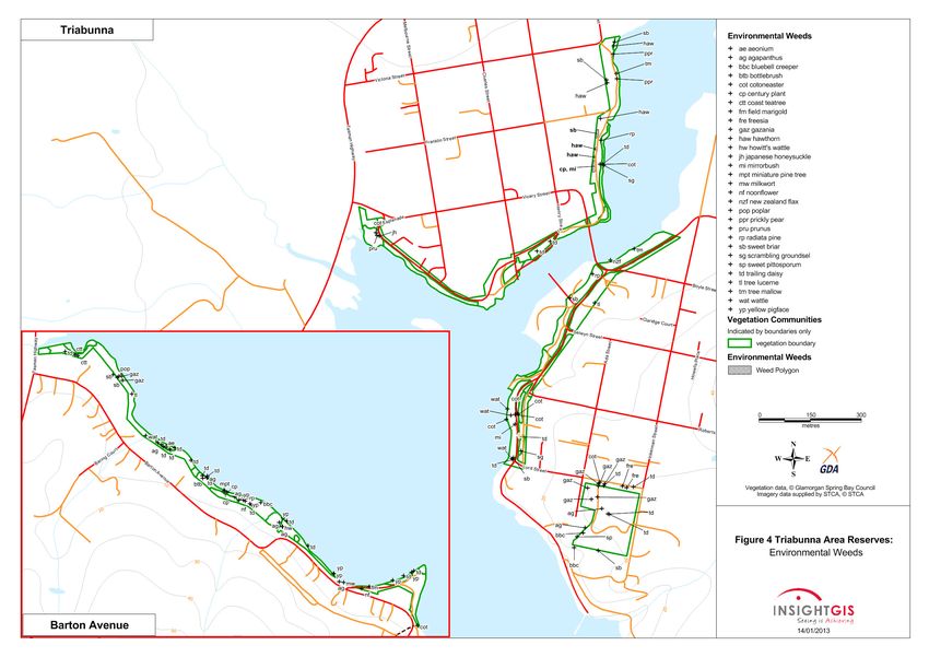
GSBC – Triabunna Area Reserves
                                           Native Flora and Fauna Management Plan 2014 – 2019

                                    SUMMARY
Glamorgan Spring Bay Council has developed this five year Native Flora and Fauna
Management Plan for the Triabunna area Reserves under their management. The
intent of the Plan is to provide Council with a strategic approach to the sustainable
management of the Reserves.
Remnant native vegetation in the Reserves includes the following communities:
   • Eucalyptus ovata forest & woodland (DOV)
   • Eucalyptus amygdalina forest & woodland on sandstone (DAS)
   • Eucalyptus globulus dry forest & woodland (DGL)
   • Eucalyptus viminalis – E. globulus coastal forest & woodland (DVC)
   • Bursaria – Acacia woodland & scrub (NBA)
   • Succulent saline herbland (ASS)
   • Lowland Themeda triandra grassland (GTL)
   • Coastal grass and herbfield (GHC)
DOV, DAS, DGL and DVC are listed as threatened communities under the Nature
Conservation Act 2002.
Other Tasveg non-native vegetation mapping units present are:
   •   Urban areas (FUR).
Two threatened plant species, Limonium baudinii and Cynoglossum australe, that are
variously listed under the Tasmanian Threatened Species Protection Act 1995 (TSPA)
and/or the Commonwealth Environment Protection and Biodiversity Conservation
Act 1999 (EPBCA), are present in the Reserves.
The condition of the vegetation varies from excellent to very poor. However, it provides
a diversity of habitat for native fauna. Fours species of threatened fauna, variously
listed under the TSPA and/or EPBCA, for which the Reserves provide potential
foraging habitat are the white-bellied sea-eagle, swift parrot, forty-spotted pardalote
and fairy tern.
Notable weeds are mapped and described. These include 6 species of ‘declared weeds’
under the Weed Management Act 1999 and 30 other species considered as
environmental weeds.
Management issues identified include:
    • Natural values –vegetation, flora, fauna and significant trees
    • Weeds
    • Illegal clearing of vegetation
    • Reserve boundaries
    • Coastal erosion and foreshore access
    • Plantings and revegetation
    • Fire
Recommendations and actions plans are provided to deal with these issues and guide
management of the Reserves for all of their natural values whilst not compromising
their associated cultural and social values.

                                           i
GSBC – Triabunna Area Reserves
                                          Native Flora and Fauna Management Plan 2014 – 2019

ACKNOWLEDGMENTS

Project Management: Mel Kelly, Natural Resources Manager
Fieldwork: Dr. Nicky Meeson, Biodiversity Officer
Report preparation: Dr. Nicky Meeson and Mel Kelly
Additional input from: David Tucker (Fire Management); Rosie Jackson,
(Aboriginal Heritage); Maureen Martin Ferris, East Coast Heritage Museum Curator
and Judie Hastie (Post European Settlement Heritage).
Consultation: Tony Pollard, Works Manager
Mapping*: Insight GIS
Photographs: Dr. Nicky Meeson, Biodiversity Officer
Weed identifications: Tasmanian Herbarium

*Maps in this publication have been reduced from their original A3 format. Hard
copies of A3 maps are available upon request from:
NRM Department
Glamorgan Spring Bay Council
(03) 6256 4777

                                         ii
GSBC – Triabunna Area Reserves
                                                 Native Flora and Fauna Management Plan 2014 – 2019

                                          CONTENTS
1 . I N TR O D U C TI O N                                                                      1
  1.1 BACKGROUND AND OBJECTIVES                                                                1
  1.2 GENERAL DESCRIPTION OF THE RESERVE                                                       1
     Figure 1 – Location of Triabunna Area Reserves                                            3
2 . B I O L O G I C AL C H AR AC T E R I S TI C S                                              4
  2.1 VEGETATION                                                                               4
  2.2 FLORA OF CONSERVATION SIGNIFICANCE                                                       7
  2.3 FAUNA HABITAT                                                                            9
  2.4 FAUNA OF CONSERVATION SIGNIFICANCE                                                       9
  2.5 SIGNIFICANT TREES                                                                       10
  2.6 WEEDS                                                                                   10
  2.7 PHYTOPHTHORA CINNAMOMI                                                                  12
     Figure 2 – Triabunna Reserves: vegetation, threatened flora & significant trees          13
     Figure 3 – Triabunna Reserves: declared weeds                                            14
     Figure 4 – Triabunna Reserves: environmental weeds                                       15
3 . O TH E R R E S E R V E V AL U E S                                                        16
  3.1 CULTURAL HERITAGE                                                                       16
  3.2 RECREATIONAL VALUES                                                                     16
  3.3 EDUCATIONAL VALUES                                                                      16
  3.4 SUMMARY OF OTHER VALUES                                                                 16
4 . M AN AG E M E N T I S S U E S                                                            17
  4.1 NATIVE VEGETATION, FLORA, FAUNA AND SIGNIFICANT TREES                                   17
  4.2 WEEDS                                                                                   18
  4.3 ILLEGAL CLEARING OF VEGETATION                                                          20
  4.4 RESERVE BOUNDARIES                                                                      21
  4.5 COASTAL EROSION AND FORESHORE ACCESS                                                    21
  4.6 PLANTINGS AND REVEGETATION                                                              21
  4.7 FIRE                                                                                    22
  4.8 PLAN REVIEW                                                                             23
5 . AC TI O N P L AN S                                                                       24
  5.1 WEED ACTION PLAN                                                                        25
  5.2 GENERAL ACTION PLAN                                                                     26
REFERENCES                                                                                   29
  APPENDIX 1 – SURVEY METHODS                                                                 30
  APPENDIX 2 – VASCULAR PLANT SPECIES LIST                                                    31
  APPENDIX 3A – REVIEW OF THREATENED FLORA                                                    41
  APPENDIX 3B – REVIEW OF THREATENED FAUNA                                                    43
  APPENDIX 4A – LEGISLATIVE OBLIGATIONS RELEVANT TO NATURAL VALUES OF
  RESERVES                                                                                    45
  APPENDIX 4B – OTHER LEGISLATION AND POLICIES RELEVANT TO RESERVE
  MANAGEMENT                                                                                  47
  APPENDIX 5A – DECLARED WEED PHOTOS                                                          48

                                                iii
GSBC – Triabunna Area Reserves
                                 Native Flora and Fauna Management Plan 2014 – 2019

APPENDIX 5B – ENVIRONMENTAL WEED PHOTOS                                       50

                                iv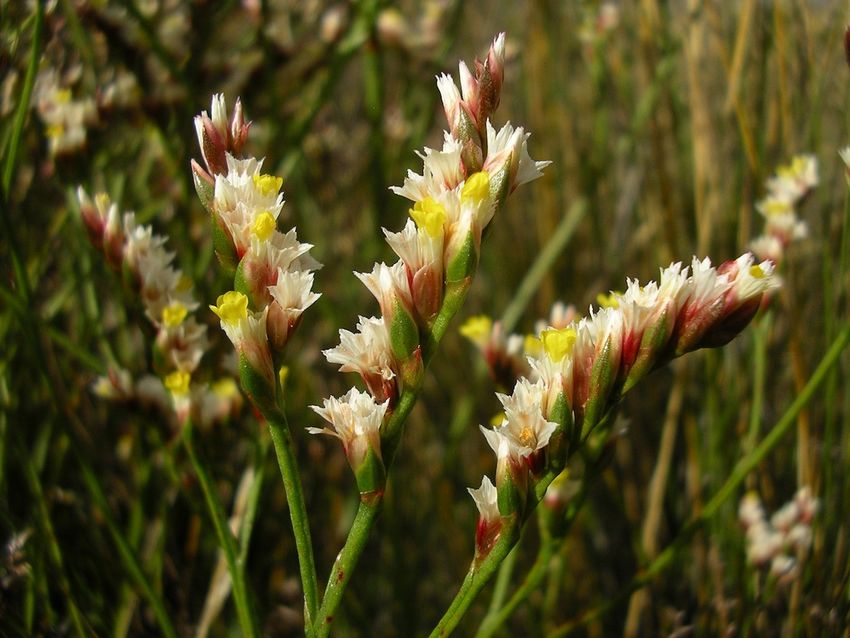
GSBC – Triabunna Area Reserves
                                                                 Native Flora and Fauna Management Plan 2014 – 2019

1.   INTRODUCTION

     1.1 B A C K G RO U N D          AN D     O B J E CT I VE S
     Glamorgan Spring Bay Council has developed this five year Native Flora and Fauna
     Management Plan for the Triabunna Area Reserves in proximity to the coast that are
     under their management. The intent of the Plan is to provide Council with a strategic
     approach to the management of the Reserves’ natural values whilst recognising and
     considering the Reserves’ significant cultural and social values.
     Therefore the main objectives of the Plan are to:
         •    Identify the natural, and associated cultural and social values of the Reserves,
         •    Identify threats to the natural values,
         •    Provide action plans to ensure that the Reserves are sustainably managed to
              preserve and enhance all of their natural values, in accordance with the
              Tasmanian Reserve Management Code of Practice 20031, whilst not
              compromising their cultural and social values, and
         •    Raise community awareness of the values of the Reserves and thereby encourage
              participation in activities that minimise threats to these values.

     1.2 G E N E R AL D E S C RI P T I O N            OF THE        R E S E RV E
     Triabunna is situated on the east coast, in the Glamorgan Spring Bay municipality and in
     the Tasmanian South East bioregion2. It occurs in the moist subhumid warm climatic
     zone where the annual average rainfall is in the region of 600 mm. The altitude across
     the Reserve ranges from near sea level to approximately 30 m above a.s.l.
     The location of the Reserves is depicted in Figure 1. They include sections of the
     foreshore in the town on both sides of Vicarys Rivulet estuary, the ‘Inkerman Street
     Reserve’ (between Inkerman and Ada Streets, on the southern side of Lord Street) and
     the foreshore parallel to Barton Avenue between the Tasman Highway and One Tree
     Point.
     The foreshore sections, within the town and along Barton Avenue, are dominated by
     parkland with patches of remnant native vegetation or remnant native trees. Facilities
     include walking paths, picnic tables, barbeques and parking areas.
     In the town, Esplanade West and East traverse the Reserves along the edges of the
     estuary. The Information Centre is located within the Reserve on the western side of the
     estuary. Access to the marina is also provided on the western side.
     The Inkerman Street Reserve is dominated by native vegetation and is traversed by a
     network of walking tracks.
     The main characteristics of the Reserves are provided in the table below. Section 2
     provides a more detailed description of the natural values and other biological
     characteristics of the Reserves. Section 3 provides details of other values of the Reserves.

     1Parks and Wildlife Service, Forestry Tasmania and Department of Primary Industries, Water and Environment 2003.
     2IBRA5 – Peters & Thackway 1998. A bioregion is an area of land with similar environmental, physical and climatic
     conditions and containing characteristic ecosystems.

                                                               1
GSBC – Triabunna Area Reserves
                                                  Native Flora and Fauna Management Plan 2014 – 2019

Reserve characteristics:

                                  Extent
P.I.D.    Location                         Land tenure        Management responsibility
                                   (ha)

                                           Authority Land     Recreation purpose - Triabunna
          Foreshore along
1716406                            2.9     Crown Lands Act    Crown License
          Esplanade West
                                           DPIPWE             Glamorgan Spring Bay Council

                                                              Reclamation - Charles St, Triabunna
          Foreshore along                  Crown Land/
7271225                            0.3                        Crown License
          Esplanade West                   Crown Licence
                                                              Glamorgan Spring Bay Council

          Foreshore along                  Authority Land     Triabunna – Esplanade – Recreation
          western bank of
1869808   Vicarys Rivulet          2.4     Crown Lands Act    Crown License
          estuary (north & east
          of Esplanade West)               DPIPWE             Glamorgan Spring Bay Council

                                           Public Reserve     Recreation – Spring Beach, Orford
          Foreshore and road
1717601   verges traversed by      4.5     Crown Lands Act    Crown License
          Esplanade East
                                           DPIPWE             Glamorgan Spring Bay Council

                                           Public Reserve
          Inkerman Street                                     Recreation – Ada St, Triabunna
5968846                             3      Crown Lands Act
          Reserve                                             Crown Land Services
                                           DPIPWE

                                                              Authority Land
          Barton Avenue                    Glamorgan Spring
5969785                             4                         Public Reserve
          foreshore                        Bay Council
                                                              Glamorgan Spring Bay Council

Natural features:
Coastal vegetation including dry sclerophyll forest, non-eucalypt forest, saltmarsh and
grassland communities, rocky and sandy shores, and remnant native trees within parkland.
Parkland, recreation areas and infrastructure:
Walking tracks, grassy parkland, park benches, barbeque and picnic areas, the Information
Centre, public toilets, public roads and parking areas and access to the foreshore, public boat
ramp and marina.

                                                2
GSBC – Triabunna Area Reserves
    Native Flora and Fauna Management Plan 2014 – 2019

3
GSBC – Triabunna Area Reserves
Native Flora and Fauna Management Plan 2014 – 2019
2. BIOLOGICAL CHARACTERISTICS
The following details the natural values (vegetation, flora and fauna habitat) and other
biological characteristics (weeds and plant pathogens) of the Reserves.
The information provided below is based on the results of a recent survey. The methods
adopted for the survey and for assessment of conservation significance are provided in
Appendix 1.
A list of vascular plants that occur within the Reserves is provided in Appendix 2. A
review of the potential of the Reserves to support threatened species known to occur in
the vicinity is provided in Appendices 3A and 3B.
The Council’s legislative obligations in relation to the management of threatened species
and communities as well as weeds occurring in the Reserves are provided in Appendix
4A. Other legislation and policies relevant to reserve management are provided in
Appendix 4B.
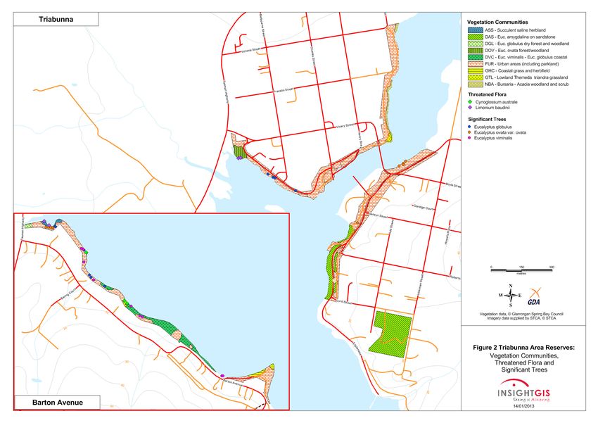
2.1 V E G E T A T I O N
The vegetation has been classified according to the TASVEG3. The survey revealed a
greater variation in the vegetation compared with current TASVEG coastal mapping of
the Reserves, which is slightly more generalised.
Figure 2 depicts the vegetation communities and other TASVEG mapping units, which
were mapped during the survey. In summary, across the Reserves there are eight native
vegetation communities present. These include four dry eucalypt forest communities,
one non-eucalypt forest communities, one saltmarsh community and two grassland
communities.
The condition of the native vegetation varies from poor to excellent. A number of weeds
are present in some communities, although only a few weeds are abundant. However,
given the proximity to urban areas, this is to some extent only to be expected. Detailed
descriptions of the significant (declared and environmental) weeds present are provided
in section 2.6.
The only other TASVEG mapping unit present is ‘Urban areas’, which is classified as
under the heading of ‘non-native vegetation’. This mapping unit dominates most of the
Reserves.
Table 1 provides a list of all mapping units within the Reserves together with the
conservation status of the native vegetation. Detailed descriptions of each mapping unit
are provided following table 1.
3 TASVEG is the abbreviation for the Tasmanian Vegetation Mapping Program (the vegetation map of the entire State)
4GSBC – Triabunna Area Reserves
Native Flora and Fauna Management Plan 2014 – 2019
Table 1. Native vegetation communities and other TASVEG mapping units in
the Reserves.
Listed under the
Tasveg
Tasveg community name Tasmanian Nature
code
Conservation Act 2002
NATIVE VEGETATION COMMUNITIES
DOV Eucalyptus ovata (black gum) forest & woodland Yes
DAS Eucalyptus amygdalina (black peppermint) forest & woodland Yes
on sandstone
DGL Eucalyptus globulus (blue gum) dry forest & woodland Yes
DVC Eucalyptus viminalis-Eucalyptus globulus (white gum-blue Yes
gum) coastal forest & woodland
NBA Bursaria-Acacia (prickly box-silver wattle) woodland & scrub
ASS Succulent saline herbland
GTL Lowland Themeda triandra (kangaroo grass) grassland
Coastal grass & herbfield
GHC (not represented in Figure 2 as it occurs as narrow strips along
the foreshores which could not be mapped)
NON-NATIVE VEGETATION
FUR Urban areas (including parkland)
Eucalyptus ovata (black gum) forest & woodland (DOV)
This threatened community occurs as one small patch near the corner of Esplanade West
and Tasman Highway.
Under the canopy of black gums the understorey tree layer is dominated by silver wattle.
Other trees and tall shrubs include oyster bay pine, dogwood, prickly box, prickly moses
and pinkwood. The ground layer is dominated by sedges, grasses and low shrubs. A small
patch of the adjacent saltmarsh intrudes into the this community
This condition of this community is moderate. Significant weeds present include
blackberry, Japanese honeysuckle and cotoneaster as well as a few weedy herbs and
grasses.
Eucalyptus amygdalina (black peppermint) forest & woodland on
sandstone (DAS)
Remnants of this threatened community occur at the Inkerman Street Reserve and along
the southern end of Esplanade East.
The community at the Inkerman Street occurs as a woodland formation (meaning a
sparse canopy). Black peppermint is the dominant tree but white gum is also present.
The most common understorey tree is silver wattle. Other small trees are common
native-cherry, prickly box and black sheoak. The ground layer has a dense and highly
diverse cover low shrubs, herbs, grasses, sagg and sedges.
The condition of the Inkerman Street community is generally excellent, but some
significant weeds are present. The most insidious of these is spanish heath which occurs
in relative abundance in the south eastern section of the remnant. A few other garden
escapes are present, although in low abundance, in the western section. These include
bluebell creeper, sweet briar, sweet pittosporum, agapanthus and gazania.
Along Esplanade East there are four remnants intersected by the road. Black peppermint
and white gum are co-dominant over-storey trees. The understorey tree and tall shrub
5GSBC – Triabunna Area Reserves
Native Flora and Fauna Management Plan 2014 – 2019
layer is often dense and includes black sheoak, prickly box, silver wattle and common
native-cherry. The ground layer is dominated by grasses, sedges, sagg and herbs.
The condition of the remnants along the edge of the bay is moderate. Several shrubby
weeds are present, the most abundant of which is an introduced wattle. The smaller
remnants that are intersected by roads are in much poorer condition. Montpellier broom
is a common weed in these remnants.
Eucalyptus globulus (blue gum) dry forest & woodland (DGL)
A small patch of this threatened community occurs near the corner of Tasman Highway
and the Barton Avenue foreshore. It consists of several old-growth blue gums and few
black wattle and dogwood. It is in very poor condition with the ground layer dominated
by weedy grasses and herbs and, most significantly, a dense patch of blackberry.
Eucalyptus viminalis-Eucalyptus globulus (white gum-blue gum) coastal
forest & woodland (DVC)
This threatened community occurs along the middle section of the Barton Avenue
foreshore. White gums are dominant with black peppermints occasionally present. The
understorey is often dominated by the broadleaf hopbush but black sheoak, black wattle
and oyster bay pine are also common. The ground layer is dominated by low shrubs,
grasses, sedges and herbs.
The condition of the community is variable depending on the degree of disturbance or
intrusion by adjacent gardens. However, generally it is in good to very good condition.
Bursaria-Acacia (prickly box-silver wattle) woodland & scrub (NBA)
This community occurs as a very narrow strip along the western edge of Vicarys Rivulet,
to the north of the Boyle Street bridge. Silver wattle dominates but other trees and shrubs
present include black gum, common native-cherry, prickly box, blackwood and drooping
sheoak. The ground layer includes a few native low shrubs, grasses, sagg and herbs.
It also appears that there has been some planting of native shrubs at the southern end of
the community, although not all are local native species.
The condition of the community is moderate to poor. Apart from weedy grasses and
herbs some significant weeds are also present, including Spanish heath, Montpellier
broom and scrambling groundsel.
Succulent saline herbland (ASS)
This saltmarsh community occurs as a small patch close to the western end of the Barton
Avenue foreshore. It is dominated by ground-hugging plants, notably glasswort, shiny
swampmat and creeping brookweed. Grasses and sedges are also very common,
including coast speargrass and sea rush.
It is generally in very good condition although species of plantain are present in patches.
Lowland Themeda triandra (kangaroo grass) grassland (GTL)
Two small patches of this community occur in the Reserves, on the eastern side of the
Boyle Street bridge and on the Barton Avenue foreshore. Kangaroo grass is the dominant
grass but other native grasses are also present. These remnant grasslands are also rich in
low or prostrate shrubs, herbs and small sedges.
Both patches are in moderate condition. Weeds include introduced grasses and some
herbs.
Coastal grass & herbfield (GHC)
This community occurs along sections of the foreshores. They are very narrow strips that
are too narrow to be mapped and depicted on Figure 2, except for a patch near One Tree
Point. They are most prominent along the south western edge of Esplanade West, the
6GSBC – Triabunna Area Reserves
Native Flora and Fauna Management Plan 2014 – 2019
north eastern edge of Esplanade East and along most of the length of the Barton Avenue
foreshore.
Coast speargrass, a large tussock grass, is usually the dominant species with other very
common species including chaffy sawsedge and sea rush. Common herbs include
southern seablite, sea-celery and native pigface.
These strips are generally in very good condition. Only a few introduced herbs, such as
buckshorn plantain and creeping orache, can tolerate such saline conditions.
Urban areas (including parkland) (FUR)
All areas that are largely devoid of native vegetation have been mapped as FUR. Most of
these areas are comprised of grassy parkland with, or without, facilities such as walking
tracks and picnic areas. Additionally, FUR includes public roads, parking areas and the
Information Centre.
FUR also includes areas where at some stage in the past the native vegetation has been
cleared adjacent to private property. Often these areas are infested with a wide array of
weedy grasses and herbs as well as a number of significant weeds, some of which have
obviously been deliberately planted.
2.2 F L O R A OF C O N S E R V AT I O N S I G N I F I C AN C E
A total of 190 vascular plant species were recorded during the survey including 2
threatened species and 79 introduced species. A full species list is given in Appendix 2.
The threatened species, Tasmanian sea-lavender and coast houndstongue, are variously
listed under the Tasmanian Threatened Species Protection Act 1995 (TSPA) and/or the
Commonwealth Environment Protection and Biodiversity Conservation Act 1999
(EPBCA). Further details are provided below.
Appendix 3A lists a total of 15 species of conservation significance previously recorded
within the vicinity together with a description of their preferred habitat and an
assessment of their likely occurrence within the Reserves.
In summary, apart from the two species recorded, there are 2 other species that are
considered as having a moderate potential to occur in the Reserves. These are soft
peppercress and shade peppercress. Further targeted surveys may reveal their presence.
Habitat in the Reserves is generally unsuitable or only marginal for the other 11 species.
Threatened flora recorded in the Reserves
Tasmanian sea-lavender (Limonium baudinii) (TSPA & EPBCA: Vulnerable)
This Tasmanian endemic plant is known only from the saltmarshes around Triabunna. It
is a short-lived perennial herb with a basal rosette of leaves and erect flowering stems 20
to 45 cm tall.
It is similar in overall appearance to the yellow sea-lavender (also a threatened species)
but in 1986 it was described as a separate species by a Russian botanist using material
collected during Nicolas Baudin’s expedition to Tasmania in 1802. A recent study4 has
indicated that there is no overlap in the distribution of the two species and no other
populations of the Tasmanian sea-lavender have been found. Threats to this species
include: landfill; catchment modification; fire; grazing; off-road vehicles; and exotic
species invasion5.
4 Schahinger 2004
5 Threatened Species Section 2008
7GSBC – Triabunna Area Reserves
Native Flora and Fauna Management Plan 2014 – 2019
During the survey a few plants were observed near the DOV community at the western
end of Esplanade West and many more are present in the ASS community along the
Barton Avenue foreshore (Plates 1 & 2 and Figure 2).
Coast houndstongue (Cynoglossum australe) (TSPA: Rare)
Coast houndstongue commonly occurs near the coast and in dry places such as the
landward margins of sand dunes, grassland and open forest. It is a perennial herb with a
cluster of basal leaves as well as stem leaves. The stems are erect, spreading, rough and
hairy up to 1m tall. The tiny flowers, commonly blue or pink, are produced in spring and
summer.
Over 30 plants were recorded along the Barton Avenue foreshore (Plate 3 and Figure 2).
Plate 1: Tasmanian sea-lavender (close-up of flowers). Plate 2: Tasmanian sea-lavender (whole plant).
Plate 3: Coast houndstongue.
8GSBC – Triabunna Area Reserves
Native Flora and Fauna Management Plan 2014 – 2019
2.3 F A U N A H A BI T AT
The diverse nature of the vegetation across all the Reserves, together with the interface
with the marine environment, equates to a diverse range of habitat opportunities for
native fauna, most notably for terrestrial and coastal birds, as well as mammals, reptiles
and a variety of invertebrates.
2.4 F A U N A OF C O N S E R V A T I O N S I G N I F I C AN C E
Appendix 3B lists threatened fauna species that have been recorded within the vicinity of
the Reserves or that are considered to have the potential to occur. A brief discussion is
given to indicate the reasons why habitat is suitable or unsuitable.
In summary, the Reserves are unlikely to provide core breeding habitat for any
threatened fauna species. However, they do provide potential foraging habitat for the
white-bellied sea-eagle, swift parrot, forty-spotted pardalote and fairy tern.
Additionally the shoreline, in some parts of the Reserves, provides high quality foraging
habitat for the fairy tern and a number of shorebirds that, whilst not listed as threatened,
are of high conservation significance. Further details are provided below.
White-bellied sea-eagle (Haliaeetus leucogaster) (TSPA: Vulnerable)
White-bellied sea-eagles nest and forage near the coast as well as near inland rivers and
lakes. They generally nest within 5 km of open water and breed between August and
January. Their nests are usually in large sheltered eucalypts, although they can be fairly
tolerant of disturbance. They perch in a prominent place and glide down snatching fish,
eels or birds from the surface of the water, or small vertebrates or carrion on land. Their
home range may be up to 150 km.
Known nests in the vicinity are beyond the range of any disturbance from activities
within the Reserves. However, the eagle is known to forage along the coast in the
Triabunna area. The many large eucalypts in the Reserves may provide perching habitat
for this species.
Swift parrot (Lathamus discolour) (TSPA & EPBCA: Endangered)
Swift parrots are annual migrants to the east coast of Tasmania, from August to March,
where they breed, nesting in tree hollows. They feed on the nectar of Tasmanian blue
gum (Eucalyptus globulus) and black gum (E. ovata), in forests, single trees in paddocks,
and urban parks and gardens.
Known nest sites in the vicinity are south of Orford. However, the many blue and black
gums in the reserves provide suitable foraging habitat.
Forty-spotted pardalote (Pardalotus quadragintus) (TSPA & EPBCA:
Endangered)
This Tasmanian endemic bird is restricted largely to headlands, peninsulas and nearby
islands in the eastern part of the State. It occurs only dry grassy forest and woodland
containing mature white gum (Eucalyptus viminalis). Breeding colonies form around
white gums where they feed in the foliage and nest in tree hollows, branch cavities, dead
stumps, fence posts or other fallen wood.
Threats include loss of mature white gums throughout the species range, particularly in
areas close to known colonies. A known colony is present on nearby Maria Island and
dispersing fledgling may feed on the many mature white gums within the Reserves.
Fairy tern (Sterna nereis nereis) (TSPA & EPBCA: Vulnerable)
Breeding habitat includes sand or shingle beaches, dunes, estuaries, lakes and near
coastal islands especially sites with driftline debris. Beach nests are exposed scrapes in
the sand, shingle or on rock between the high water mark and coastal vegetation.
9GSBC – Triabunna Area Reserves
Native Flora and Fauna Management Plan 2014 – 2019
Some of the threats to these species include disturbance and destruction of nests through
trampling by humans, domestic animals and stock; predation by rats, dogs and cats;
habitat destruction through inappropriate coastal development, clearing, grazing and
frequent fire; and the introduction of exotic plants such as marram grass, gorse,
boneseed and African boxthorn.
For a number of years fairy terns have nested and successfully raised young on the sand
spit at the mouth of the Prosser River in nearby Orford. The waters adjacent to the
Reserves in Triabunna provide potential foraging habitat for these birds.
Shore birds
Shorebirds of conservation significance that are known to utilise the adjacent shorelines
of the Reserves as foraging habitat include:
• Hooded plover (Thinornis rubricollis)
• Pied oystercatcher (Haematopus longirostris)
• Red-capped plover (Charadrius ruficapillus)
These birds breed in scrapes in the sand or in seaweed above the high water mark. Their
numbers around Tasmanian has declined over recent years mainly due to increased
beach use by people. Activities which threatened their breeding success include
trampling by people, predation of eggs, chicks and adults by dogs and feral cats, invasive
weeds, removal of seaweed and other beach debris and ingestion or entanglement in
litter, especially fishing line.
2.5 S I G N I F I C AN T T R E E S
In addition to the many trees within the native vegetation communities there area many
large mature eucalypts within areas mapped as ‘FUR – parkland’. These include blue
gums (Eucalyptus globulus), black gums (E. ovata)) and white gums (E. viminalis). The
location of these is depicted in Figure 2.
Apart for the aesthetic, visual and cultural value of these trees, they provide valuable
foraging and nesting habitat for a range of native birds. They are particularly important
as foraging habitat for the and swift parrot and forty-spotted pardalote as well as
potential perching habitat for the white-bellied sea-eagle (see section 2.4 above).
2.6 W E E DS
Introduced species recorded during the survey numbered 70. This is over forty percent of
all species recorded.
Six of these are ‘declared weeds’ under the Tasmanian Weed Management Act 1999, five
of which are also Weeds of National Significance. Another 30 species are considered to be
significant environmental weeds. All of these species are listed in Tables 2A and 2B, a
photograph of each is provided in Appendices 5A and 5B, and their distribution is
depicted in Figures 3 and 4.
Table 2A indicates that the most widespread declared weeds are Spanish heath and
Montpellier broom. Table 2B indicates that by far the most widespread environmental
weed is trailing daisy. Other weeds that are relatively widespread are agapanthus,
cotoneaster, gazania, sweet briar and yellow pigface.
It should be noted that the number of observations provided in Tables 2A and 2B are
intended to give a general indication of relative abundance and does not always reflect
actual abundance. For example, there is likely to be more than 23 trailing daisy plants or
8 gazania plants but it would have been impractical to map each one.
10GSBC – Triabunna Area Reserves
Native Flora and Fauna Management Plan 2014 – 2019
Table 2A. Declared weeds* recorded in the Reserves.
* ‘Declared weeds’ under the Weed Management Act 1999. ** WONS = Weed of National Significance.
*** Observations = the number of general locations across the Reserves where it was observed.
Common name Scientific name WONS** Observations***
african boxthorn Lycium ferocissimum WONS 3
blackberry Rubus fruticosus aggregate WONS 7
bridal creeper Asparagus asparagoides WONS 1
gorse Ulex europaeus WONS 5
montpellier broom Genista monspessulana WONS 16
spanish heath Erica lusitanica 27
Table 2B. Other environmental weeds recorded in the Reserves.
* Observations = the number of general locations across the Reserves where it was observed.
Common name Scientific name Observations*
aeonium Aeonium arboreum 1
agapanthus Agapanthus praecox 8
bluebell creeper Billardiera heterophylla 3
bottlebrush Melaleuca sp. 1
century plant Agave americana 3
coast teatree Leptospermum laevigatum 2
cotoneaster Cotoneaster sp. 8
field marigold Calendula arvensis 1
freesia Freesia hybrid 2
gazania Gazania sp. 8
hawthorn Crataegus monogyna 4
howitt's wattle Acacia howittii 1
japanese honeysuckle Lonicera japonica 1
milkwort Polygala myrtifolia 1
miniature pine tree Crassula tetragona 1
mirrorbush Coprosma repens 2
new zealand flax Phormium tenax 1
noonflower Lampranthus glaucus 2
poplar Populus sp. 1
prickly pear Opuntia sp. 2
prunus Prunus sp. 1
radiata pine Pinus radiata 3
scrambling groundsel Senecio angulatus 2
sweet briar Rosa rubiginosa 8
sweet pittosporum Pittosporum undulatum 1
trailing daisy Osteospermum fruticosum 23
tree lucerne Chamaecytisus palmensis 1
11GSBC – Triabunna Area Reserves
Native Flora and Fauna Management Plan 2014 – 2019
Common name Scientific name Observations*
tree mallow Malva dendromorpha 2
wattle Acacia sp. 4
yellow pigface Carpobrotus edulis 7
2.7 P H Y TO PHT HO R A CINN AM OM I
Commonly known as dieback or root rot fungus, P. cinnamomi is a soil borne fungal
pathogen that invades the roots of plants and starves them of nutrients and water. Heath
communities are the most susceptible to infection with a consequent serious loss of
species diversity. It is generally spread by the transportation of soil on vehicles,
construction machinery and walking boots. The establishment and spread of P.
cinnamomi is favoured in areas that receive above 600 mm of rainfall per annum, are
below 800 m altitude and have a predominantly heathy shrub layer6.
Triabunna is situated within the favoured climatic zone of P. cinnamomi and there are
known infestations in the general area. The DAS community within the Reserves is
variably or moderately susceptible to the fungus. Although P. cinnamomi is often difficult
to detect in the field, no obvious evidence of its presence was observed during the survey.
Furthermore, several species that are susceptible to the fungus were present in the DAS
community.
6 Rudman 2005
12GSBC – Triabunna Area Reserves
Native Flora and Fauna Management Plan 2014 – 2019
13GSBC – Triabunna Area Reserves
Native Flora and Fauna Management Plan 2014 – 2019
14GSBC – Triabunna Area Reserves
Native Flora and Fauna Management Plan 2014 – 2019
15GSBC – Triabunna Area Reserves
Native Flora and Fauna Management Plan 2014 – 2019
3. OTHER RESERVE VALUES
3.1 C U L T U R AL H E RI T A G E
• Aboriginal heritage
The Reserves hold cultural significance for the contemporary Aboriginal community.
Cultural heritage values connect contemporary Aboriginal Tasmania with the people and
events of the past. The Laremairremener band from the Oyster Bay nation occupied the
area at the time of European arrival.
• Post European settlement heritage
The Post European settlement heritage values of the Reserves are closely linked with the
histories of the town and the municipality. These have been documented in various
publications, including Lester (1994), Tall (1994) and Guiler (1998).
Many other publications and historical documents and photographs on both Aboriginal
and Post European Settlement heritage are housed at the Glamorgan Spring Bay
Historical Society Inc, which is located at 22 Franklin Street, Swansea.
3.2 R E C RE A T I O N A L V AL U E S
Both residents and visitors use the Reserves for a wide range of passive and active
recreational activities. These include walking, dog exercise, wildlife viewing and fishing.
These activities are facilitated by the walking tracks along the western side of Vicarys
Rivulet estuary, Barton Avenue and throughout the Inkerman Street Reserve. Other
facilities provide additional recreational opportunities. These include barbeque and
picnic areas and access to boat ramps.
3.3 E DU C A T I O N AL V AL U E S
All the reserves in the Glamorgan Spring Bay area have educational value, whether it be
as an outdoor classroom for our local schoolchildren or for visitors to the area interested
in our natural and cultural history. There are many opportunities to communicate the
many values of our reserves to the locals and visitors alike, whether that be through
interpretation signage, walk and talks over the summer months or information brochures
and articles in the local newsletters. In the future other technology could be utilised such
as smart phones to provide interaction educational experiences.
3.4 S U M M A R Y OF O T H E R V AL U E S
Although there are many other values in our reserves this plan focuses on the
management of the native vegetation and associated biodiversity values. Other values
particularly recreational values are addressed through other processes and resourcing
avenues such as Council’s capital works and renewal programs for walking tracks,
recreational facilities, parks and gardens.
16GSBC – Triabunna Area Reserves
Native Flora and Fauna Management Plan 2014 – 2019
4. MANAGEMENT ISSUES
4.1 N A T I VE V E G E T AT I O N , F L O R A , F A U N A AN D S I G N I F I C AN T T RE E S
Maintaining the natural values of the Reserves is a primary objective of management.
Protecting native vegetation communities is the most effective way of conserving flora
and fauna values. A high priority should be given to managing threatening processes or
activities that are likely to have an impact on species and communities of high
conservation significance.
Within the Reserves these include two species of threatened flora and foraging habitat for
four threatened bird species, which are variously listed under the TSPA and/or EPBCA.
Four vegetation communities listed as threatened under the NCA are also present in the
Reserve. Legislative obligations in relation to threatened species and communities are
provided in Appendix 4.
The Inkerman Street reserve is particularly notable from a conservation perspective. It
supports a relatively extensive area of the threatened DAS community with a diverse flora
and it is generally in excellent condition. Active management to protect this reserve
should be a high priority.
With regard to shorebirds, shorelines adjacent to the Reserves are important foraging
habitat for the hooded plover, pied oystercatcher and red-capped plover. There are
information signs at several beaches in the area requesting beach users to remain below
the high water mark during the breeding season and keeping dogs and cats under
control. This issue has gained prominence with the recent GSBC/NRM South Shorebird
Project, the GSBC Dog Management Policy and the introduction of the Cat Management
Act.
In addition to the many trees within the native vegetation communities there many large
mature eucalypts present within areas mapped as ‘FUR – parkland’. As these trees
senesce they often form tree hollows which are important nesting habitat for many native
birds and small mammals. Regeneration of trees within forest communities is vital to
ensure the persistence of each community.
All mature trees are significant from a conservation perspective as well as from an
aesthetic and visual perspective. Management should aim to retain as many trees as
possible. Whilst some trees may be perceived as ‘dangerous’, it does not necessarily
follow that they should be felled. Removing potentially dangerous limbs may be all that is
required.
Recommendation 1 – Train Council staff who are involved with day-to-day
management of the Reserves to recognise the natural values present and
provide them with strategies to protect these values during management
activities.
Recommendation 2 – Develop a plan for the Inkerman Street reserve to
actively protect and enhance it and to provide educational material. A plan
could include:
• Developing a walking trail with interpretation signs and/or a brochure,
• Closing and rehabilitating minor tracks,
• Eradicating weeds (see also Recommendations 3 & 5), and
• Developing a fire management plan (see also Recommendation 12).
17GSBC – Triabunna Area Reserves
Native Flora and Fauna Management Plan 2014 – 2019
4.2 W E E DS
The Glamorgan Spring Bay Weed Management Plan (GSBWMP)7 recognise that weeds
are one of the most serious threats to the natural environment. Any plant growing
outside its natural range is a potential weed that may have a detrimental effect on the
natural values of reserves. Management objectives include eradicating weeds or
preventing or minimising their spread to native vegetation communities.
It is recognised that weed control in the Reserves is currently an ongoing day-to-day
management activity and that substantial progress has been made in reducing the levels
of weed infestation. Declared weeds are to a large extent under control although some are
still present, notably Spanish heath in the Inkerman Street reserve. Environmental weeds
are more widespread but are patchily distributed. The survey conducted for this Plan
provides a detailed inventory of weeds and the basis for a more strategic approach to
their management.
It is important in weed management planning in an urban context to recognise the
futility of eliminating all non-native species. Hence, in areas of parkland with a ground
cover of introduced grasses and herbs the focus of weed management should be on
containment.
Priorities for weed control should focus on declared and other environmental weeds that
are having, or have the potential to have, a negative impact upon the native flora and
which are also manageable. Therefore a hierarchy of priorities has been developed for
weeds in the Reserve, which are applied to each species in Tables 3A and 3B. The priority
system is as follows, where 1 is the highest priority and 3 is the lowest:
Priority Reasons for priority rating
Declared weeds, and/or
Easily controlled or eradicated, and/or
1
Only small infestations or small numbers of infestations are present, and/or
Likely to spread quickly.
Requires a substantial time allocation due to the size of infestations, and/or
2 Creepers that require all plant parts to be remove, and/or
Unlikely to spread quickly.
Plantings that require monitoring only to ensure that they do not spread.
3
Large infestations of species that would require substantial investment in
rehabilitation of the site.
NB: -Plants with more than one priority rating in Tables 3A & 3B indicate that
infestations in different locations vary in size and/or manageability.
-Most plants will require monitoring for re-emergence and follow-up control.
7 Glamorgan Spring Bay Natural Resource Management Committee 2008
18GSBC – Triabunna Area Reserves
Native Flora and Fauna Management Plan 2014 – 2019
Table 3A. Priorities for declared weeds in the Reserves.
* Observations = the number of general locations across the Reserves where it was observed.
common name Scientific name Observations* Priority
spanish heath Erica lusitanica 27 1
montpellier broom Genista monspessulana 16 1
blackberry Rubus fruticosus aggregate 7 1
gorse Ulex europaeus 5 1
african boxthorn Lycium ferocissimum 3 1
bridal creeper Asparagus asparagoides 1 1
Table 3B. Priorities for other environmental weeds in the Reserves.
* Observations = the number of general locations across the Reserves where it was observed.
** Priority 1 = outlying, small infestations.
common name Scientific name Observations* Priority
trailing daisy Osteospermum fruticosum 23 1 & 2 **
agapanthus Agapanthus praecox 8 1 & 2 **
cotoneaster Cotoneaster sp. 8 1
gazania Gazania sp. 8 1 & 2 **
sweet briar Rosa rubiginosa 8 1
yellow pigface Carpobrotus edulis 7 2
hawthorn Crataegus monogyna 4 3
wattle Acacia sp. 4 2
bluebell creeper Billardiera heterophylla 3 1
century plant Agave americana 3 1
radiata pine Pinus radiata 3 3
coast teatree Leptospermum laevigatum 2 3
freesia Freesia hybrid 2 1
mirrorbush Coprosma repens 2 1
noonflower Lampranthus glaucus 2 1
prickly pear Opuntia sp. 2 1
scrambling groundsel Senecio angulatus 2 2
tree mallow Malva dendromorpha 2 1
aeonium Aeonium arboreum 1 1
bottlebrush Melaleuca sp. 1 1
field marigold Calendula arvensis 1 1
howitt's wattle Acacia howittii 1 3
japanese honeysuckle Lonicera japonica 1 1
milkwort Polygala myrtifolia 1 1
miniature pine tree Crassula tetragona 1 1
new zealand flax Phormium tenax 1 1
poplar Populus sp. 1 3
prunus Prunus sp. 1 3
sweet pittosporum Pittosporum undulatum 1 1
tree lucerne Chamaecytisus palmensis 1 1
19GSBC – Triabunna Area Reserves
Native Flora and Fauna Management Plan 2014 – 2019
Recommendation 3 – Control Priority 1 weeds (see Tables 3A and 3B).
Recommendation 4 – Control Priority 2 weeds (see Tables 3A and 3B).
Recommendation 5 – Regularly monitor for re-growth of Priority 1 and 2
weeds, as well as the spread of Priority 3 weeds, and take follow-up control
action as necessary.
It is also important to acknowledge that the presence of most weeds recorded is probably
a consequence of the proximity of the reserves to urban areas and associated gardens,
which provide a source of ongoing infestation. Therefore, in conjunction with direct on-
ground weed control actions, a campaign to educate residents about the consequences
associated with garden escapes and garden waste dumping on the Reserves should be
ongoing.
Recommendation 6 – Continue to raise community awareness of the values
present in their local environment focusing on the threats posed to these
values most notably by garden escape plants and dumping of garden
cuttings. Such a campaign could include:
• making this Plan publicly available through the GSBC website,
• a public presentation/workshop,
• brochures/posters/articles in local news letter, and
• field days and working bees.
4.3 I L L E G AL C L E A RI N G OF VEGETATION
As noted in section 2.1 (at the end of the ‘Urban areas’ section), there are areas of the
Reserves where, at some stage in the past, the native vegetation has been cleared adjacent
to private property. Often these areas are infested with a wide array of weedy grasses and
herbs as well as a number of significant weeds, some of which have obviously been
deliberately planted.
Intermittently Council receives reports of illegal clearing of trees and other foreshore
vegetation. Usually it is difficult for Council to apprehend or prosecute offenders. One
strategy adopted in recent times has been to erect signs indicating that vegetation has
been cleared from public land without authorisation and that the sign will remain in
place until the vegetation has regrown.
Future alternative strategies could include the erection of Bush Watch signs. Bush Watch
is a Tasmania Police initiative that encourages the public to report unusual, suspicious or
criminal activity and vandalism to the Police. The signs provide a phone number (131
444), which is a direct link to the police. The GSBC Natural Resource Management
(NRM) Committee is a member of Bush Watch.
Recommendation 7 – Raise community awareness of the problem illegal
clearing, outlining the legislative implications and encouraging people to
report offender to the police. This should be in conjunction with
Recommendation 6, but also may involve the erection of signage, such as
‘Bushwatch’ signs. Investigate the development of a ‘by-law’ that addresses
the illegal clearing of vegetation on Council managed public land.
20GSBC – Triabunna Area Reserves
Native Flora and Fauna Management Plan 2014 – 2019
4.4 R E S E R VE B O U N D A RI E S
In managing any reserve it is obviously important that reserve boundaries are known to
both reserve managers and adjacent landowners. There are issues of undefined
boundaries in some sections of the Reserves. Perhaps as a consequence, some gardens
have encroached onto the reserves to varying degrees. This issue is linked to some extent
with the issue of illegal clearing.
On-ground marking of undefined boundaries may be necessary in some instances in
order to clarify the council’s authority in implementing some of the actions required to
protect the reserve values. Such on-ground markers could include fencing or a row of
large boulders. Alternatively it may merely require a verbal recognition by other land
owners.
Recommendation 8 - Clarify Reserve boundaries. Liaise with landowners
regarding the most appropriate way to more clearly define these boundaries
and, where deemed necessary, install on-ground boundary markers.
4.5 C O AS T AL E RO S I O N AN D FORESHORE ACCESS
Coastal erosion is often a natural process. For example, long shore drift results in the
alternating process of seasonal erosion and accretion of sandy beaches. In the longer
term coastal erosion is likely to be exacerbated by climate change and associated rises in
sea level and increases in the size of storm surge.
Sandy shores and saltmarshes, such as those along the Barton Avenue foreshore, are the
most susceptible to coastal erosion. Erosion can also be exacerbated by uncontrolled
foreshore access, although this does not appear to be a significant issue in the Triabunna
Reserves.
Recommendation 9 – Establish long-term photo-point monitoring sites
along sandy shores and saltmarshes in the Reserves in order to plan for
future rehabilitation or other amelioration measures.
4.6 P L AN T I N G S AN D R E V E G E T AT I O N
Plantings of introduced or non-local native species within the Reserves are present in a
most areas mapped in Figure 2 as ‘Urban areas – parkland (FUR)’. However, the use of
introduced or non-local native species should be considered carefully. Many have the
potential to ‘escape’ into native vegetation and exacerbate the problem of environment
weeds, which in turn leads to the degradation of Reserves’ natural values.
In consultation with the local community, any future plantings should preferably use
local native species, which have a number of benefits. They are adapted to the local
climate and soil and consequently require less maintenance, including watering, and the
risk of escape resulting in degradation of the natural values is nullified. Furthermore,
local native plants also attract and provide habitat for native birds, which in turn are
natural pest control agents as well as providing pleasure to a great number of people.
Following weed control, it is preferable to allow areas to naturally regenerate with native
species. However, if there is little or no nearby source of native species seed or other
21GSBC – Triabunna Area Reserves
Native Flora and Fauna Management Plan 2014 – 2019
regenerative parts then weed invasion may be ongoing. In such cases revegetation is
likely to be required. Any of the native species listed in Appendix 2 are appropriate for
revegetation work, as well as other plantings, in the Reserves.
Recommendation 10 – In consultation with the local community, any
plantings and revegetation work should preferably use local native species.
4.7 F I RE
The primary objective of fire management in reserves is to protect human life and
property from fire. Other objectives include the maintenance of biodiversity through
appropriate fire regimes and the of protection conservation values from the adverse
impacts of fire in so far as these are consistent with the primary objective.
Developing a fire management plan is complex. Many native vegetation communities and
plant species require fire to trigger regeneration. Conversely, some communities and
species are killed by fire depending on factors such as their growth stage, fire frequency
and fire intensity. Therefore the maintenance of a mosaic of fire age classes is preferable.
Total exclusion of fire may result in periodic and devastating hot summer wildfires.
Conversely, over frequent and comprehensive fuel reduction burning will also modify the
structure and composition of vegetation.
However, in a coastal setting it is generally recommended to exclude fire as fire can lead
to the destabilisation of coastal landforms and soil. The use of fire as a tool to reduce fuel
loads in urban reserves can also be controversial as well as hazardous to people and
property. Furthermore, maintaining biodiversity values whilst minimising wildfire
hazard may not always necessarily require the use of fire. Therefore alternative
approaches, such as raking litter and removing dead wood by hand is preferable8.
Recommendation 11 – Conduct regular assessments of fuel loads and
remove litter and dead wood as necessary but retain at least some large
habitat logs if they are present.
Notwithstanding the above, small patch burns may be periodically necessary if, for
example, localised fuel loads become unmanageable by other removal methods, or, as a
management tool for particular weed infestations. In such cases a fire management plan
should be developed with the advice of the Tasmania Fire Service.
Recommendation 12 – Patch burn as the need arises in accordance with a
fire management plan developed in consultation with the Tasmania Fire
Service.
8 Wood & Knee 1999
22GSBC – Triabunna Area Reserves
Native Flora and Fauna Management Plan 2014 – 2019
4.8 P L AN R E VI E W
This Native Flora and Fauna Management Plan covers the 5 year period from 2014 to
2019. A review of the Plan, including the success in achieving its objectives, is due to be
conducted in 2019 and an updated Plan will be developed. This process will be ongoing
for each consecutive 5 year period.
Recommendation 13 – Review the current Native Flora and Fauna
Management Plan near the end of the current 5 year period, including the
success in achieving its objectives, and develop a Plan for the period 2020 to
2024.
23GSBC – Triabunna Area Reserves
Native Flora and Fauna Management Plan 2014 – 2019
5. ACTION PLANS
The following tables provide action plans that are based on the above recommendations.
Table 5.1 is a weed management action plan and Table 5.2 includes all other actions.
Each action has been assigned a time frame and a performance measure.
With regard to weeds, the distribution of the declared and other environmental weeds
recorded during the survey is provided in Figures 3 and 4 and a photo of each weed is
provided in Appendices 5A and 5B. The maps and photos should be used as a resource to
guide and direct weed control actions. However, the maps should be used with caution as
the point locations of weeds were recorded with a hand-held gps with a potential error of
several metres. Furthermore, the maps should not be considered as a comprehensive
guide as some weeds may have emerged since surveys were undertaken and others may
have been missed. Additionally, as weed control is an ongoing task performed by Council
Officers, some weed may have already been treated.
24GSBC – Triabunna Area Reserves
Native Flora and Fauna Management Plan 2014 – 2019
5.1 W E E D A CT I O N P L AN
Recommendation Performance
Recommendation / Specific Action Timing
No. Measure
Eradication of weeds, or
Control Priority 1 weeds. at least, a reduction in
3 Ongoing
(See Tables 3A & 3B and Appendices 5A and 5B). weed abundance each
year.
Eradication of weeds, or
Ongoing following
Control Priority 2 weeds. at least, a reduction in
4 initial control of
(See Tables 3A & 3B and Appendices 5A and 5B). weed abundance each
Priority 1 weeds
year.
At least once a
Monitor for re-growth of Priority 1 and 2 weeds,
year in Spring Minimise new weed
5 Monitor for the spread of Priority 3 weeds, and
and infestations.
Take follow-up control action as necessary.
opportunistically
Review the success of weed control actions through further weed mapping and July-December New weed action plan in
13 develop a new weed action plan. 2019 place for 2020-2024.
25GSBC – Triabunna Area Reserves
Native Flora and Fauna Management Plan 2014 – 2019
5.2 G E N E R AL A C T I O N P L AN
Recommendation Performance
Recommendation / Action Timing
No. Measure
Train Council staff who are involved with day-to-day management of the Reserve Education of Council staff
1 to recognise the natural values present and provide them with strategies to protect 2015 and added protection of
these values during management activities. Reserve natural values.
Develop a plan for the Inkerman Street reserve to actively protect and enhance it
and to provide educational material. A plan could include:
- Developing a walking trail with interpretation signs and/or a brochure, Greater protection and
- Closing and rehabilitating minor tracks, enhancement of the
- Eradicating weeds (see also Recommendations 3 & 5), and reserve as well as public
2 - Developing a fire management plan (see also Recommendation 12). education and enhanced
Develop plan 2014 - 2016 recreational experience.
Implement plan 2017 - 2019
Continue to raise community awareness of the values present in their local
environment focusing on the threats posed to these values most notably by garden
escape plants and dumping of garden cuttings. Such a campaign should include: Education of community
6 - making this Plan publicly available through the GSBC website, Ongoing and reduction of risk of
- a public presentation/workshop, new weed infestations.
- brochures/posters/articles in local news letter, and
- field days and working bees.
26GSBC – Triabunna Area Reserves
Native Flora and Fauna Management Plan 2014 – 2019
Recommendation Performance
Recommendation / Action Timing
No. Measure
Raise community awareness of the problem illegal clearing, outlining the
legislative implications and encouraging people to report offenders to the police. Education of community
This should be combined with Recommendation 6, but also involve the erection of Ongoing and reduction of risk and
signage, such as ‘Bushwatch’ signs. These signs provide a phone number (131 reports of illegal clearing.
7 444) which is a direct link to the police.
Investigate the development of a ‘by-law’ that addresses the illegal clearing of
2015 Investigation complete.
vegetation on Council managed public land.
Clarify Reserve boundaries. Liaise with landowners regarding the most
appropriate way to more clearly define these boundaries and, where deemed
necessary, install on-ground boundary markers. Clarification of reserve
8 boundary locations.
Survey boundary line and liaise with landowners 2015
Install boundary markers as necessary 2016
Establish long-term photo-point monitoring sites along sandy shores and
saltmarshes in the Reserves in order to plan for future rehabilitation or other
amelioration measures. Record of coastal
9 erosion.
Establish monitoring sites 2014
Monitor Twice each year
In consultation with the local community, any plantings and revegetation work Natural values of
10 As required
should preferably use local native species. Reserve enhanced.
Assessment of and
Conduct regular assessments of fuel loads and remove litter and dead wood as Late winter each
11 reduction in wild fire
necessary but retain at least some large habitat logs if they are present. year
hazard.
27You can also read