2018 Arizona Statewide ITS Architecture - ADOT
←
→
Page content transcription
If your browser does not render page correctly, please read the page content below
2018 Arizona Statewide ITS Architecture

       Project Number MPD0053‐17

              Prepared for:
   Arizona Department of Transportation
    Multimodal Planning Division (MPD)

                 July 2018

               Prepared by:
           Ayres Associates, Inc.
     Parsons Transportation Group, Inc.
       United Civil Group Corporation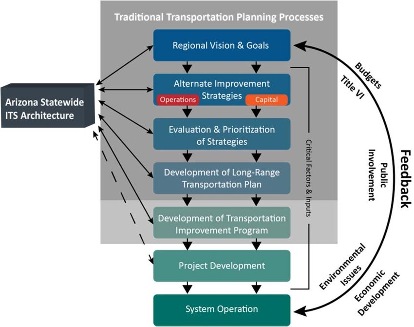
TABLE OF CONTENTS
1.0     ACRONYMS ........................................................................................................................................................... 1
2.0     INTRODUCTION ..................................................................................................................................................... 4
    2.1 PROJECT MANAGEMENT TEAM ............................................................................................................................................... 6
    2.2 PURPOSE AND NEED ............................................................................................................................................................. 6
3.0     REGIONAL DESCRIPTION ....................................................................................................................................... 9
4.0     RELATED ARCHITECTURES ................................................................................................................................... 10
5.0     PARTICIPATING AGENCIES AND OTHER STAKEHOLDERS ....................................................................................... 11
6.0     INVENTORY OF EXISTING AND PLANNED ITS RESOURCES ..................................................................................... 12
    6.1 ITS PLANNING FOR OPERATIONS ........................................................................................................................................... 14
    6.2 OPERATIONAL GOALS, OBJECTIVES AND PERFORMANCE MEASURES ............................................................................................. 15
    6.3 NEEDS AND SERVICES .......................................................................................................................................................... 16
7.0     ARCHITECTURE COMPONENTS ............................................................................................................................ 20
    7.1 SUBSYSTEM AND TERMINATOR INVENTORY.............................................................................................................................. 21
    7.2 INTERFACES ....................................................................................................................................................................... 26
    7.2.1 INTERCONNECT DIAGRAMS ............................................................................................................................................... 26
    7.2.2 INFORMATION FLOW DIAGRAMS ....................................................................................................................................... 29
8.0     FUNCTIONAL REQUIREMENTS ............................................................................................................................. 31
9.0     OPERATIONAL CONCEPT ..................................................................................................................................... 32
10.0 IMPLEMENTATION .............................................................................................................................................. 33
    10.1 PROJECT SEQUENCING ...................................................................................................................................................... 33
11.0 AGREEMENTS...................................................................................................................................................... 48
12.0 STANDARDS ........................................................................................................................................................ 49
    12.1 STANDARDS DEVELOPMENT ORGANIZATIONS (SDO) .............................................................................................................. 50
       12.1.1    Benefits of Using Standards ........................................................................................................................ 50
       12.1.2    Stages of Development of Standards .......................................................................................................... 51
       12.1.3    ITS Standards in Procurement Specifications .............................................................................................. 51
       12.1.4    Decision Making Strategies for Standards................................................................................................... 51
       12.1.5    Relationship to ARC‐IT ................................................................................................................................. 52
13.0 MAINTENANCE PLAN .......................................................................................................................................... 53
    13.1 USE OF THE STATEWIDE ITS ARCHITECTURE .......................................................................................................................... 53
       13.1.1      Using the Statewide ITS Architecture in Planning ....................................................................................... 54
       13.1.2      Using the Statewide ITS Architecture in Design........................................................................................... 54
       13.1.3      Using the Statewide ITS Architecture in Procurement ................................................................................. 54
       13.1.4      Using the Statewide ITS Architecture in Deployment .................................................................................. 55
    13.2 STATEWIDE ITS ARCHITECTURE MAINTENANCE ..................................................................................................................... 55
       13.2.1 Responsibility for Maintaining the Statewide ITS Architecture .......................................................................... 56
       13.2.2 What is Maintained in the Statewide ITS Architecture ....................................................................................... 56

                                                                                             i
13.2.3 Maintenance Interval of the Statewide ITS Architecture .................................................................................... 58
        13.2.4 How Changes are Identified ................................................................................................................................ 59
        13.2.5 Request, Document Review, Decide, Implement, Release .................................................................................. 60
14.0 RESOURCES ......................................................................................................................................................... 61

Appendix A – Stakeholders
Appendix B – Inventory Summary
Appendix C – Service Packages
Appendix D – Physical Objects
Appendix E – Interconnect Service Package Diagrams
Appendix F – Interconnect Context Diagrams
Appendix G – Interconnects
Appendix H – Flow Definitions
Appendix I – Flow Service Package Diagrams
Appendix J – Flow Context Diagrams
Appendix K – Information Flows
Appendix L – Functional Requirements
Appendix M – Roles and Responsibilities
Appendix N – Project vs. Service Package Summary
Appendix O – Agreements
Appendix P – Standards

                                                                                     ii
1.0 ACRONYMS
    Acronym    Description
    AAMVA      American Association of Motor Vehicle Administrators
    AASHTO     American Association of State Highway and Transportation Officials
    ADEM       Arizona Division of Emergency Management
    ADEQ       Arizona Department of Environmental Quality
    ADMS       Archived Data Management Subsystem
    ADOT       Arizona Department of Transportation
    ALERT      Arizona Local Emergency Response Team
    ALISS      Accident Location Identification Surveillance System
    ANSI       American National Standards Institute
    APTA       American Public Transportation Association
    ARC‐IT     Architecture Reference for Cooperative and Intelligent Transportation
    ARIS       AZTech Regional Info System
    ASTM       Advanced Public Transportation System
    ASU        Arizona State University
    ATMS       American Society of Testing and Materials
    ATSPT      Arizona Tribal Strategic Partnering Team
    AVI        Automated Vehicle Identification
    AVL        Automatic Vehicle Location
    BIA        Bureau of Indian Affairs
    BQAZ       Building a Quality Arizona
    BRT        Bus Rapid Transit
    CAD        Computer‐Aided Dispatch
    CAG        Central Arizona Governments
    CalTrans   California Department of Transportation
    CBP        US Customs and Border Protection
    CCM        County, City, Municipal Government
    CCTV       Closed Circuit Television
    CDC        Consolidated Dispatch Center
    COF        City of Flagstaff
    COG        Councils of Government
    COSV       City of Sierra Vista
    COY        City of Yuma
    CYMPO      Central Yavapai Metropolitan Planning Organization
    CV         Commercial Vehicle
    CVAS       Commercial Vehicle Administration Subsystem
    CVC        Commercial Vehicle Check
    CVCS       Commercial Vehicle Check Subsystem
    CVISN      Commercial Vehicle Information Systems and Network
    CVO        Commercial Vehicle Operations
    CVRIA      Connected Vehicle Reference ITS Architecture
    CVS        Commercial Vehicle Subsystem
    DEMA       Arizona Division of Emergency and Military Affairs
    DMS        Dynamic Message Sign
    DPS        Department of Public Safety
    DSRC       Dedicated Short Range Communications
    DUST       Dual Use Safety Technology

                                       1
Acronym   Description
ECD       Enforcement Compliance Division
EM        Emergency Management
EMS       Emergency Medical Services
ESP       Emergency Service Patrol
ETC       Electronic Toll Collection
EVS       Emergency Vehicle Subsystem
FAST      Fixing Arizona’s Surface Transportation
FHWA      Federal Highway Administration
FMPO      Flagstaff Metropolitan Planning Organization
FMS       Freeway Management System
FMSCA     Federal Motor Carrier Safety Agency
FTA       Federal Transit Administration
HAR       Highway Advisory Radio
HAZMAT    Hazardous Materials
HCRS      Highway Condition Reporting System
HPMS      Highway Performance Monitoring System
ICM       Integrated Corridor Management
IC        Incident Command
ICE       Immigration and Customs Enforcement
IDO       Infrastructure Delivery and Operations Division
IEEE      Institute of Electrical and Electronics Engineers
IFTA      International Fuel Tax Association
IP        Interconnect Protocol
IPAWS     Integrated Public Alert Warning System (International Registration Plan)
ISP       Information Service Provider
ITE       Institute of Transportation Engineers
ITS       Intelligent Transportation System
IVR       Interactive Voice Response
LHMPO     Lake Havasu Metropolitan Planning Organization
LRTP      Long Range Transportation Plan
MAG       Maricopa Association of Governments
MAP‐21    Moving Ahead for Progress in the 21st Century Act of 2012
MCDOT     Maricopa County Department of Transportation
MCO       Maintenance and Construction Operations
MCM       Maintenance and Construction Management
MCV       Maintenance and Construction Vehicle
MOU       Memorandum of Understanding
MPD       Multimodal Planning Division
MPO       Metropolitan Planning Organization
MVD       Motor Vehicle Division
NACOG     Northern Arizona Council of Governments
NAIPTA    Northern Arizona Intergovernmental Public Transportation Authority
NAU       Northern Arizona University
NEMA      National Electrical Manufacturers Association
NOAA      National Oceanic and Atmospheric Administration
NTCIP     National Transportation Communications for ITS Protocol
PAG       Pima Association of Governments
PAPS      Public Safety Answering Point
PDT       Project Development Team

                                  2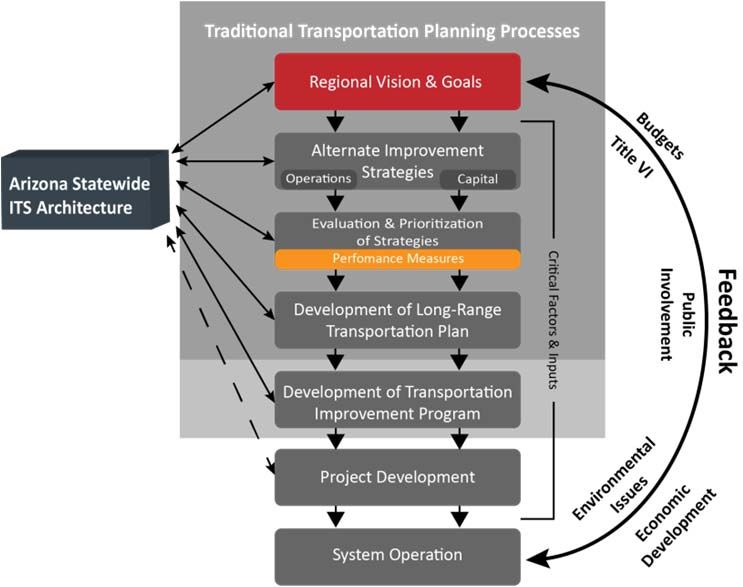
Acronym   Description
PMT       Project Management Team
POE       Port of Entry
PTZ       Pan‐Tilt‐Zoom
RAD‐IT    Regional Architecture Development for Intelligent Transportation
RADS      Regional Archived Data System
RCRS      Road Condition Reporting System
RFP       Request for Proposal
RFS       Radar Feedback Sign
ROW       Right‐of‐Way
RTMC      Regional Traffic Management Center
RTMS      Remote Traffic Microwave Sensor
RTP       Regional Transportation Plan
RTS       Remote Traveler Support
RWIS      Road Weather Information System
SAE       Society of Automotive Engineers
SAFER     Safety Fitness Electronic Record
SCMPO     Sun Corridor Metropolitan Planning Organization
SDO       Standards Development Organization
SEAGO     Southeastern Arizona Governments Organization
SET‐IT    Systems Engineering Tool for Intelligent Transportation
SHL       State Highway Log
STIP      State Transportation Improvement Plan
SPaT      Signal Phasing and Timing
SVMPO     Sierra Vista Metropolitan Planning Organization
TIP       Transportation Improvement Plan
TMA       Transportation Management Association
TMC       Traffic Management Center
TMS       Traffic Management Subsystem
TOC       Traffic Operations Center
TSMO      Transportation Systems Management and Operations
USDOT     United States Department of Transportation
VII       Vehicle Infrastructure Integration
VMS       Variable Message Signs
VSL       Variable Speed Limit
WACOG     Western Arizona Council of Governments
WIM       Weigh in Motion
YCAT      Yuma County Area Transit
YCIPTA    Yuma Country Intergovernmental Public Transportation Authority
YMPO      Yuma Metropolitan Planning Organization

                                 3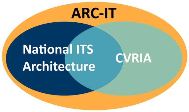
2.0 INTRODUCTION
In 2013, Arizona Department of Transportation (ADOT) developed the Arizona Statewide Intelligent
Transportation Systems (ITS) Architecture to provide a roadmap for transportation systems
integration. The architecture was developed through a cooperative effort by the State’s
transportation and emergency management agencies, covering all modes of transportation on all
highways within Arizona. It represented a shared vision of how each agency’s systems would work
together and share information and resources to provide safer, more efficient, and more effective
transportation systems for travelers in the State of Arizona. The architecture provided an overarching
framework that spans all the State’s transportation organizations, emergency response, and individual
transportation projects. Using the architecture, each transportation project could be viewed as a part
of the overall transportation system, providing visibility into the relationships between individual
transportation projects and ways to cost‐effectively build an integrated transportation system over
time. The 2013 Statewide ITS Architecture was developed based on the National ITS Architecture
Version 7.0.

Since that time, the United States Department of Transportation (USDOT) initiated a major update
that covers all the scope and contents from the National ITS Architecture and integrates the
Connected Vehicle Reference ITS Architecture (CVRIA). FIGURE 1. ARC‐IT Venn Diagram, shows the
integrated relationship between these architectures. The merging of these two products, now
referred to as the Architecture Reference for Cooperative and Intelligent Transportation (ARC‐IT),
provides a common framework for planning, defining, and integrating intelligent transportation
systems. ARC‐IT reflects the contributions of a broad cross‐section of the ITS community including
transportation practitioners, systems engineers, system developers, technology specialists and
consultants.

                                    FIGURE 1. ARC‐IT Venn Diagram

                                                  4
One of the Federal Highway Administration’s (FHWA) main goals in the creation of ARC‐IT was the
development of a standardized nomenclature that could be used nationwide. Generic ITS service
descriptions, Service Packages, were developed (e.g., traffic signal control, transit vehicle tracking)
that provide desired services used throughout various regions in the United States. Within the
boundaries of the ARC‐IT structure, ITS planners, combined with stakeholder input, tailored ARC‐IT to
create the Arizona Statewide ITS Architecture that meet Arizona’s specific needs. This standardization
allows Arizona’s ITS inventory components to be aligned with FHWA’s standard terminology. Once
Arizona’s ITS inventory was mapped to ARC‐IT, then the uniform National ITS standard requirements
connected defined flows within the Arizona Statewide ITS Architecture to follow the provided
framework.

ARC‐IT is used when developing and deploying nationally compatible systems. By ensuring system
compatibility, the USDOT hopes to accelerate ITS integration nationwide and develop a strong, diverse
marketplace for related projects and services. Use of ARC‐IT presents significant benefits as follows:
   1. Provides assistance with technical design and saves considerable time because physical and
       logical architectures are already defined;
   2. Defines information flows and process specifications, which accelerates the process of defining
       system functionality;
   3. Identifies standards that will support interoperability now and into the future, but leaves
       selection of technologies to local decision makers; and
   4. Offers a sound engineering framework for integrating multiple applications and services in a
       region.

ARC‐IT includes a set of interconnected components that are organized into four views, focusing on
the four different architecture perspectives.
    1. Enterprise View considers ITS from an organization perspective. It identifies stakeholders and
       their organizations. It also defines roles and relationships between stakeholders.
    2. Functional View looks at ITS from a practical perspective and defines the requirements needed
       to make a system work.
    3. Physical View defines the physical objects and describes transportation systems and the
       information exchanges that support ITS.
    4. Communications View defines how physical objects communicate and the communications
       standards, profiles, and security required to share information between the physical objects.

Security is paramount in the 21stCentury of Intelligent Transportation Systems and ARC‐IT addresses
security concerns spanning all four views. Security concerns, related to ITS, are focused on protection
of surface transportation information and infrastructure. Surface transportation is now, more than
ever, relying on information technologies to sense, collect, process and disseminate information to
improve the efficiency of moving goods and people, improve the safety of our transportation system
and provide travel alternatives.

                                                   5
The 2018 Arizona Statewide ITS Architecture (AZ ITS Architecture) is a customized version of ARC‐IT,
including only the subsystems and functions that are planned for implementation within the State.
The update included a review of goals and objectives of stakeholders, updated stakeholders list,
documentation of actual inventory, interviews with stakeholders and mapping of inventory to system
elements. This ITS architecture is a living document which is used for ITS project planning and
development within the State for the next 10 years. While this report documents the process and
results, the RAD‐IT database is the AZ ITS Architecture.
2.1 Project Management Team
This ITS Architecture update is led by a Project Management Team (PMT). The role of the PMT is to
provide technical guidance, support, advice, suggestions, recommendations, and to perform
document reviews throughout the study process. PMT members include representatives from ADOT
Multimodal Planning Division (MPD) and Transportation Systems Management and Operations
(TSMO) Division in conjunction with the Consultant Team.
2.2 Purpose and Need
FHWA Highway Funds are based upon communications and agreements between transportation
agencies to provide effective, integrated services. Simply stated, every public service related to
intelligent transportation systems is described in one or more of the ARC‐IT service packages; e.g.,
traffic monitoring, signal control, emergency response, emergency evacuation, connected and
autonomous vehicle applications. The AZ ITS Architecture allows the state of Arizona and agency
stakeholders to participate in Highway Trust Funds.
Federal regulations, 23CFR Parts 655 and 940 Intelligent Transportation System Architecture and
Standards, require that federally funded projects must conform to the new ARC‐IT standards, be
guided by a regional architecture of geographic boundaries defined by stakeholder needs, and use a
system engineering analysis that considers the total project life cycle. According to the regulations,
every project must be included in a regional ITS architecture or have a specific project architecture for
federal funding to be used on the project. As a result, ADOT determined that a comprehensive review,
conforming to the federal guidelines, is needed to update and enhance the AZ ITS Architecture. ADOT
believes this enhancement is necessary and will keep all statewide stakeholders involved in the
process of keeping current and being proactive about technology.
The FHWA rule and the FTA policy contained in the federal regulations states that, “ITS projects shall
conform to the National ITS Architecture and standards in accordance with the requirements
contained in this part. Conformance with the National ITS Architecture is interpreted to mean the use
of the National ITS Architecture to develop a regional ITS architecture, and the subsequent adherence
of all ITS projects to that regional ITS architecture. Development of the regional ITS architecture
should be consistent with the transportation planning process for Statewide and Metropolitan
Transportation Planning.” (FHWA/FTA 2001)
6A regional ITS architecture shall be developed to guide the development of ITS projects and programs
and be consistent with ITS strategies and projects contained in applicable transportation plans. The
National ITS Architecture shall be used as a resource in the development of the regional ITS
architecture. Provision should be made to include participation from the following agencies, as
appropriate, in the development of the regional ITS architecture: Highway agencies; public safety
agencies (e.g., police, fire, emergency/medical); transit operators; Federal lands agencies; state motor
carrier agencies; and other operating agencies necessary to fully address regional ITS integration.
At a minimum, a regional ITS architecture shall include the following (Federal Highway Administration
2017):
1. A description of the region
2. Identification of participating agencies and other stakeholders
3. An operational concept that identifies the roles and responsibilities of participating agencies
and stakeholders in the operation and implementation of the systems included in the regional
ITS architecture
4. Any agreements (existing or new) required for operations, including at a minimum those
affecting ITS project interoperability, utilization of ITS related standards, and the operation of
the projects identified in the regional ITS architecture
5. System functional requirements
6. Interface requirements and information exchanges with planned and existing systems and
subsystems (for example, subsystems and architecture flows as defined in the National ITS
Architecture)
7. Identification of ITS standards supporting regional and national interoperability
8. The sequence of projects required for implementation
To assist in the development of the Statewide ITS Architecture, the FHWA provides two software tools
to apply ARC‐IT to ITS elements (United States Department of Transportation 2018):
1. Regional Architecture Development for Intelligent Transportation (RAD‐IT) is a database tool
used to assist planners in creating a statewide or regional ITS Architecture. The database
houses information such as the regional stakeholders, an inventory of technology, selected
service packages, roles and responsibilities of stakeholders, technological standards and
agreements between organizations.
2. Systems Engineering Tool for Intelligent Transportation (SET‐IT) is a tool used for individual
project guidance through the systems engineering process.
ARC‐IT and RAD‐IT were used to complete the AZ ITS Architecture.
FIGURE 2. Planning Lifecycle for Projects illustrates the planning and lifecycle of ITS projects. The
planning process identifies the direction and guides the project development. The project
development process provides the concept of operations and systems requirements so projects can
7be implemented. SET‐IT advances the project development process by integrating drawing and
database tools to develop project architectures that align with ARC‐IT. The SET‐IT output includes the
concept of operations, standards, and security measures for project implementation. Through
monitoring and evaluation of implemented projects, information is supplied to the transportation
planning process and the cycle repeats.
FIGURE 2. Planning Lifecycle for Projects
83.0 REGIONAL DESCRIPTION
This AZ ITS Architecture is an update to the 2013 Arizona Statewide ITS Architecture owned by ADOT.
There are three existing ITS architectures within the State.
1. AZ Statewide ITS Architecture
2. Maricopa Association of Governments (MAG) Regional ITS Architecture, June 2013
3. Pima Association of Governments (PAG) Tucson Metropolitan Region Intelligent
Transportation Systems Strategic Deployment Plan for the 21st Century, July 2004.
The AZ ITS Architecture interacts with the two regional architectures but is separate and focuses on
ADOT‐owned ITS elements and all other ITS elements outside of the two regional architectures. Some
of the MAG and PAG regional architecture elements may be included in the AZ ITS Architecture, as
required.
The statewide transportation planning strategy used to develop this AZ ITS Architecture represents
multimodal transportation that supports the vision laid out in Building a Quality Arizona (BQAZ)
combined with “What Moves You
Arizona”, the State’s Long‐Range
Transportation Plan (which advances
the BQAZ vision by defining a preferred
investment strategy). The AZ ITS
Architecture adopts the goals and
strategies from these plans.
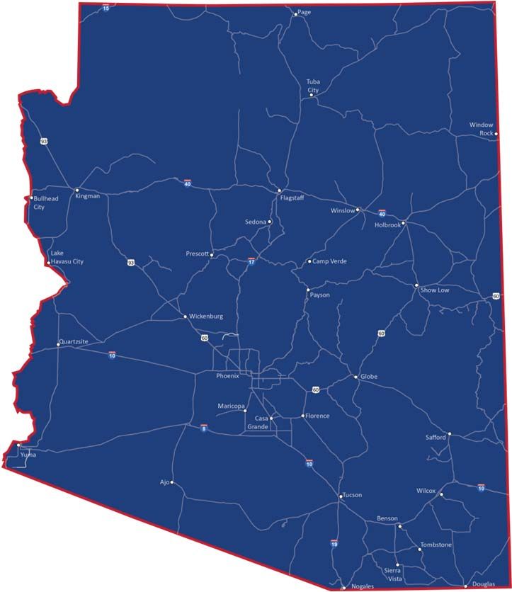
FIGURE 3. Study Boundary represents
the geographic scope of the AZ ITS
Architecture. The boundary includes
the entire State of Arizona and its
borders with Mexico and the States of
California, New Mexico, Utah, and
Nevada.
FIGURE 3. Study Boundary
94.0 RELATED ARCHITECTURES
In addition to the MAG and PAG ITS Regional Architectures, ADOT will share operations and data with
surrounding states to varying degrees. Therefore, the statewide ITS architectures listed below are
included in the AZ ITS Architecture and reflect a portal for connectivity, where appropriate.
1. California Statewide ITS Architecture (Caltrans 2017)
2. 2012 New Mexico Statewide ITS Architecture Update (Consystec 2012)
3. 2013 Southern Nevada Regional ITS Architecture (Nevada DOT 2013)
4. Utah Statewide ITS Architecture
105.0 PARTICIPATING AGENCIES AND OTHER STAKEHOLDERS
The development of this Statewide ITS Architecture is a collaborative process; therefore, the
participation of key stakeholders is critical to its success. To develop a thorough understanding of the
issues, deficiencies and needs, current and planned ITS projects throughout the State, the PMT
identified an extensive group of stakeholders. TABLE 1. Stakeholders presents the participating
agencies and other stakeholders that were relied upon to provide input, identify needs, and build
consensus throughout the state.
TABLE 1. Stakeholders
Stakeholders
ADOT American Association of Archive Data Users Arizona Cities and Towns
Motor Vehicle
Administrators (AAMVA)
Arizona Counties Arizona Department of Arizona Department of Arizona Division of
Environmental Quality Public Safety (DPS) Emergency and Military
(ADEQ) Affairs (DEMA)
Arizona MPOs and COGs Arizona Tribal Strategic Arizona Universities AZTech
Partnering Team (ATSPT)
Bureau of Indian Affairs Emergency Medical (EM) Federal Highway Federal Motor Carrier Safety
(BIA) Transport Companies Administration (FHWA) Agency (FMSCA)
Financial Institutions GIS Mapping Designers I‐10 Corridor Coalition Independent School Districts
International Fuel Tax Maricopa Association of Maricopa County Media
Association (IFTA) Governments (MAG) Department of
Transportation (MCDOT)
Mexico Governmental National Oceanic Pima Association of Private Commercial Carriers
Agencies Atmospheric Administration Governments (PAG)
(NOAA)
Private Container System Private Information Service Public and Private Transit Rail Organizations
Owners Providers Providers
State of California State of Nevada State of New Mexico State of Utah
Time and Data Sources Travelers Tribal Governments ‐ US Customs and Border
Statewide Protection (CBP)
US Immigration and
Customs Enforcement (ICE)
Source: AZ ITS Architecture RAD‐IT Database
Appendix A. Stakeholders presents the Stakeholder, Stakeholder Description and Group Members as displayed
in RAD‐IT.
116.0 INVENTORY OF EXISTING AND PLANNED ITS RESOURCES
An important initial step in the ITS Architecture update process was to verify the existing inventory
and add new or planned ITS elements.
Step 1: Stakeholders were provided with a list of their existing stakeholder agency description along
with their ITS Architecture inventory in accordance with the 2013 ITS Architecture.
Step 2: Individual meetings were held with stakeholders to discuss their existing inventory and
planned projects. Some of those meetings included but were not limited to:
1. Yuma Metropolitan Planning Organization and their member agencies
2. Flagstaff Metropolitan Planning Organization and their member agencies
3. Lake Havasu Metropolitan Planning Organization and their member agencies
4. Central Arizona Association of Governments and their member agencies
5. Sun Corridor Metropolitan Planning Organization and their member agencies
6. Western Arizona Council of Governments and their member agencies
7. Southeastern Arizona Government Organization and their member agencies
8. Sierra Vista Metropolitan Planning Organization and their member agencies
9. Northern Arizona Council of Governments and their member agencies
10. Central Yavapai Metropolitan Planning Organization and their member agencies
11. Arizona Department of Public Safety
12. US Customs and Border Protection
13. AzTech and Maricopa County Department of Transportation
14. University of Arizona
15. Northern Arizona University
16. Hopi Tribe
Step 3: Stakeholders completed an updated inventory using a comprehensive survey answering
questions about existing, planned and future systems for incorporation into the AZ ITS Architecture.
Step 4: A comprehensive review of all existing plans throughout Arizona that identify ITS elements or
functions that should be included in the ITS Architecture was completed.
TABLE 2. Inventory is a partial list of the stakeholder inventory of ITS components. The inventory
represents the status of ITS deployments as of March 2018. Per the ITS Architecture Maintenance
Plan, periodic updates of the inventory should be conducted to document the on‐going deployment of
ITS technology throughout Arizona. The complete inventory can be found in Appendix B. Inventory.
12TABLE 2. Inventory
Element Element Associated
Stakeholder Element Description
Name Status Physical Objects
The interactive voice response (IVR) telephone
system providing statewide traveler information
Transportation
for the State of Arizona. The 511 IVR system may
ADOT ADOT 511 IVR Existing Information
include travel time information, construction
Center
information, roadway incidents, and special
events.
The interactive voice response (IVR) telephone
system providing statewide traveler information
Traveler
for the State of Arizona. The 511 IVR system may
ADOT ADOT 511 IVR Existing Information Voice
include travel time information, construction
System
information, roadway incidents, and special
events.
ADOT's www.az511.gov website provides
statewide traveler information systems for the
Transportation
ADOT 511 State of Arizona. The system includes freeway
ADOT Existing Information
Website video images, travel time information, and
Center
roadway incidents. Public access to the
information is provided via the internet.
ADOT has an official App that provides real time
information to travelers about unplanned major
ADOT Alerts
ADOT events that are impacting traffic so informed Existing Media
App
decisions can be made to avoid lengthy delays or
potentially hazardous situations.
Source: AZ ITS Architecture RAD‐IT Database
136.1 ITS Planning for Operations
The traditional transportation planning process includes the development of regional goals,
identification of alternative improvement strategies, evaluation and prioritization of strategies,
development of the transportation plan and transportation improvement programs. Arizona
developed the long‐range transportation plan, titled What Moves You Arizona 2040 and the State
Transportation Improvement Program for 2018‐2022 to guide the progress of the statewide network
of highways, transit systems, airports, local roads and bicycle/pedestrian facilities.
Planning for technology‐based operations activities is fundamentally different than planning for
traditional capital improvement projects. However, the AZ ITS Architecture relies on Arizona’s long‐
range transportation plan and transportation improvement program and must be compatible with the
state goals and objectives. FIGURE 4. Arizona Statewide ITS Architecture Use in Planning for
Operations provides a view of the statewide planning process and how the AZ ITS Architecture fits
into that process.
FIGURE 4. Arizona Statewide ITS Architecture Use in Planning for Operations
146.2 Operational Goals, Objectives and Performance Measures
The initial step in the objectives‐driven, performance‐based approach to statewide ITS architecture is
to establish statewide goals and operations objectives. Goals and objectives that focus on the
operational performance of the transportation system in the planning process are included in the
previous statewide ITS architecture, the Statewide Transportation Implementation Plan (STIP), MPO
transportation plans, or the statewide long‐range transportation plan.
Operations objectives are specific, measurable, and agreed‐upon statements of desired outcomes for
regional system performance that support the plan's goals. They may be formed in response to input
from ITS and operations staff, elected or appointed officials, or a significant event such as a dust
storm, or major traffic incident that draws public attention to needed operational improvements.
Performance measures to track the achievement of operations objectives are identified during the
development of the objectives and are typically embedded in operations objectives. For example: the
operations objective—improve average travel time during peak periods by 5% by year 2025 on
regionally significant arterials is tracked by the performance measure ‐ average travel time. The ITS
elements from the stakeholder inventory shows several archive databases that perform this task and
track travel times. That information is shared statewide through the statewide performance measures
HPMS. FIGURE 5. Regional Vision and Goals represents the portion of the traditional transportation
planning process that addresses the vision, goals, and performance measures from traditional
transportation planning process and shows how it is related to the AZ ITS Architecture.
FIGURE 5. Regional Vision and Goals
15The Federal Moving Ahead for Progress in the 21st Century Act of 2012 (MAP‐21) and the Fixing
Arizona’s Surface Transportation (FAST) Act of 2015 established national performance goals for the
federal aid highway program in seven areas:
1. Safety – reduce traffic fatalities and serious injuries on all public roads
2. Infrastructure Conditions – Maintain the National Highway System in a state of good repair
3. Congestion Reduction – Reduce congestion on the National Highway System
4. System Reliability – Improve the efficiency of the surface transportation system
5. Freight Movement & Economic Vitality – Improve the national freight network, strengthen
rural access to national/international markets and support economic development
6. Environmental Sustainability – Enhance performance of the transportation system while
protecting and enhancing the national environment
7. Reduced Product Delivery Delays – Reduce project costs, promote jobs and the economy, and
expedite the movement of people and goods by accelerating project completion by eliminating
delays in the project development and delivery process.
Using the requirements established by the federal government, Arizona developed their
transportation vision and goals as presented in Arizona’s 2040 Long Range Transportation Plan. The
Statewide ITS Architecture can help stakeholders realize these goals and operations objectives by
using them to organize supportive ITS capabilities and select service packages, functional
requirements, and project concepts that move the objectives toward success. Conversely,
architectures and regional ITS strategic plans can help planning organizations define operations
objectives that reflect available data and the expertise of operations staff for metropolitan or
statewide transportation plans.
6.3 Needs and Services
The fundamental foundation of the ITS Architecture’s planning process is to establish collaboration
and coordination among agencies involved with the operations of ITS in the state. It contains
information about existing and planned systems to increase statewide visibility and coordination of all
ITS deployments. Planners and implementing agencies should use the architecture to identify which
agencies in the state need to be involved in a project; how ITS elements in a project should interface
with neighboring systems; and how the project can leverage other deployments to lower costs and
provide travelers with seamless service.
Connecting the already well‐established planning practices in the state with identified needs and
services, benefits Arizona. One of the important phases in developing the ITS architecture is to
identify statewide needs and determine which ITS services should be implemented to address those
needs. Arizona’s 2040 Long Range Transportation Plan and the Transportation Improvement Plan
2018‐2022 were relied on to identify Arizona’s needs and services. Many of the long‐term policies and
goals in these plans will be fulfilled by the services contained in the AZ ITS Architecture. For example,
if new major facilities are planned in the state, and; it is appropriate to incorporate ITS elements in to
16the facility, the alternate improvement strategy for capital improvements may be included in this
project. TABLE 3. Relationship to Planning shows the objectives, descriptions, and sources that were
used to identify the needs. Performance measures are also listed to illustrate the success of the
objective.
TABLE 3. Relationship to Planning
Performance
Performance
Objective Description of Needs Source Measure
Measures
Category
Decrease Travel
Delay
The needs in this category focus on the Mobility
application of control devices, such as traffic Mitigate
signals, signing, gates, to regulate the Congestion
Improve
number of vehicles entering or leaving the AZ Long Range Quick Clearance
Mobility,
freeway to achieve operational objectives. Transportation Safety & ‐ Measure time
Reliability and
Potential Policies/Strategies: Access Plan (LRTP) Security it takes to clear
Accessibility
Management, Complete Streets, Methods, crashes
Models, and Data, Research and Integration Number of
of systems Strengthen Meetings and
Partnerships Agreements
Signed
Resources
Maintain State
available for
Improve pavement and bridge deficiencies. Transportation
State Highway
Maintain the state roadway system. Manage System
Preserve and AZ Long Range Maintenance
the existing system efficiently and
Maintain the Transportation Mitigate
effectively. Mobility
System Plan (LRTP) Congestion
Potential Policies/Strategies: Expanded
Focus on
Maintenance and Operations Policy. Strengthen
Implementation
Partnerships
Policies
Focus on
Strengthen
The need is to maintain, preserve and Implementation
Partnerships
extend the service life of the existing and Policies
Preserve and future infrastructure. AZ Long Range Change in
Maintain the Potential Policies / Strategies: Transportation Vehicle‐related
Support Air
System Context sensitive solutions Plan (LRTP) emissions, level
Quality
Education and Outreach of
Improvement
"Green" Certification environmental
certification
17Performance
Performance
Objective Description of Needs Source Measure
Measures
Category
Ensue responsible management of public Focus on
Strengthen
resources and implement funding strategies Implementation
Partnerships
to ensure long term balanced investment of Policies
the state transportation system.
Potential Policies/Strategies:
Job creation/retention
AZ Long Range
Promote Fiscal Access Management
Transportation Resources
Stewardship Complete Streets Support
Plan (LRTP) available for
Demand Management Economic
economic
System Modernization (bottleneck Growth
initiatives
reduction, system operations, traffic signal
timing, effective transportation systems
support job growth, job retention and
economic growth).
Increase and
Access
The need is to continue to improve and Measure
Management
advocate for transportation system safety Shared Access
AZ Long Range
for all modes. Decrease Travel
Enhance Safety Transportation
Potential Policies/Strategies: Delay
Plan (LRTP)
Congestion, speed and improved access Mobility
management. Mitigate
Congestion
Decrease Travel
Delay
Mobility
Mitigate
Congestion
Decrease
Fatality and
The need is to continue to improve and Serious Injury
advocate for transportation system safety Rates
Safety &
for all modes.
AZ Long Range Security
Potential Policies/Strategies: Quick Clearance
Enhance Safety Transportation
System Modernization (Rural Safety) ‐ Measure time
Plan (LRTP)
Implement quick clearance measures; it takes to clear
enhance safety and security for travelers crashes
and for incident responders. Focus on
Implementation
Policies
Strengthen
Partnerships Number of
Meetings and
Agreements
Signed
18Performance
Performance
Objective Description of Needs Source Measure
Measures
Category
The need to develop and nurture Number of
AZ Long Range
Strengthen partnerships that support coordination, Strengthen Meetings and
Transportation
Partnerships integration and preservation Partnerships Agreements
Plan (LRTP)
Signed
Resources
Maintain State
available for
Transportation
State Highway
System
Maintenance
Decrease Travel
Better link to planning and programming
Delay
through performance based decision
Make Effective AZ Long Range Mobility
making.
Investment Transportation Mitigate
Potential Policies/Strategies:
Decisions Plan (LRTP) Congestion
methods, models and data, research,
Decrease in
reporting, promotes fiscal stewardship Safety &
Fatalities and
Security
Serious Injuries
Focus on
Strengthen
Implementation
Partnerships
Policies
To help build consensus on statewide needs and ITS services priorities, the consultant team hosted
meetings at various Metropolitan Planning Organizations (MPOs) and Councils of Government (COGs),
as well as with statewide stakeholder member agencies. The main goal is to connect stakeholder
visions with the visions and objectives of the statewide LRTP. The statewide ITS Architecture update
allows stakeholders to expand the interaction of planning and operations.
197.0 ARCHITECTURE COMPONENTS
The service packages are defined using the 12 area groups:
1. Commercial Vehicle Operations
2. Data Management
3. Maintenance and Construction
4. Parking Management
5. Public Safety
6. Public Transportation
7. Support
8. Sustainable Travel
9. Traffic Management
10. Traveler Information
11. Vehicle Safety
12. Weather
Service packages are used to define functional requirements. ARC‐IT defines service packages as slices
of the physical view that address specific services like traffic signal control. A service package collects
several different physical objects (systems and devices) and their functional objects and information
flows that provide the desired service. For each service package, ARC‐IT provides a brief description
and a set of high level functional requirements, customized to reflect requirements of the Statewide
ITS Architecture.
The Consultant Team screened the service packages contained in ARC‐IT version 8.1 to identify those
packages that are most applicable to the State of Arizona. TABLE 4. Service Packages presents a
partial list of service packages. The full list of service packages selected for the AZ ITS Architecture is
included in Appendix C. Arizona Service Packages.
20TABLE 4. Service Packages
Service
Service Service Package
Service Package Description Package
Package Name
Status
CVO01 Arizona Carrier This service package manages a fleet of commercial vehicles. The Fleet and Planned
Operations and Freight Management Center monitors the vehicle fleet and can provide
Fleet Management routes using either an in‐house capability or an external provider. Routes
generated by either approach are constrained by hazardous materials and
other restrictions (such as height or weight). A route would be
electronically sent to the Commercial Vehicle with any appropriate
dispatch instructions. The location of the Commercial Vehicle can be
monitored by the Fleet and Freight Management Center and routing
changes can be made depending on current road network conditions.
CVO01 Carrier Operations This service package manages a fleet of commercial vehicles. The Fleet and Planned
and Fleet Freight Management Center monitors the vehicle fleet and can provide
Management routes using either an in‐house capability or an external provider. Routes
generated by either approach are constrained by hazardous materials and
other restrictions (such as height or weight). A route is electronically sent
to the Commercial Vehicle with any appropriate dispatch instructions. The
location of the Commercial Vehicle can be monitored by the Fleet and
Freight Management Center and routing changes can be made depending
on current road network conditions. This service package also supports
maintenance of fleet vehicles with on‐board monitoring equipment.
Records of vehicle mileage, preventative maintenance and repairs are
maintained.
CVO03 Arizona Electronic This service package provides for high speed weigh‐in‐motion with or Existing
Clearance without Automated Vehicle Identification (AVI) capabilities. This service
package provides the roadside equipment that could be used as a stand‐
alone system or to augment the Electronic Clearance (CVO03) service
package.
Source: AZ ITS Architecture RAD‐IT Database
7.1 Subsystem and Terminator Inventory
Once the needs and service packages were identified, the next step in the development of the AZ ITS
Architecture was to identify the subsystems and terminators that are necessary to work together to
deliver transportation services. These subsystems, terminators, and the interconnections and
information exchanges among them, are the primary foundation of the architecture.
Subsystems are individual pieces of the overall Intelligent Transportation System that perform specific
functions such as managing traffic, providing traveler information, or responding to emergencies.
Subsystems can be associated with particular organizations such as departments of transportation,
information service providers, or public safety agencies. They are sources and/or users of information
provided by other subsystems within or on the boundary of the ITS Architecture. Subsystems include
21center systems, field components, vehicle equipment and traveler devices that participate in ITS (US
Department of Transportation 2006).
Terminators are the physical objects that define the boundary of an architecture. In ARC‐IT
terminators represent the people, systems, and general environment that interface to ITS. The
interfaces between terminators and the subsystems and processes within ARC‐IT are defined, but no
functional requirements are allocated to terminators. The functional and physical views of ARC‐IT
have the same set of terminators. The only difference is that functional view processes communicate
with terminators using data flows, while physical view subsystems use information flows. (USDOT
2018)
One of the most recognized representations of the previous ITS Architecture, the ITS Sausage
Diagram, has been replaced with FIGURE 6. Arizona’s Physical View V8 Subsystem Diagram. Figure 6
shows the subsystems and how they interconnect with each other. This diagram illustrates ARC‐IT’s
view of the possible interactions among ITS elements. Subsystems within the Physical View Diagram
that are light in color are not yet established for the State of Arizona.
FIGURE 6. Arizona’s Physical View V8 Subsystem Diagram
22A subsystem can have multiple implementations; for example, ADOT Traffic Management and the
District Field Offices could all operate traffic management centers. Each implementation is a distinct
ITS element. ITS elements are considered the basic building blocks of the architecture and are the
names used by stakeholders to describe components of their ITS operations. TABLE 5. ITS Elements
Within the Physical View (Subsystems) depicts a list of stakeholder elements that are associated with
each type of subsystem to highlight the types of elements that make up each subsystem. The table is
color coded to help distinguish among the five basic classes of subsystems defined in the Physical
View Diagram. Appendix D provides a complete list of all the subsystems and terminators and a
definition of their role and functions.
TABLE 5. ITS Elements Within the Physical View (Subsystems)
SUPPORT SYSTEMS
Archived Data System
AAMVA Driver and Vehicle Verification Systems ADOT ALISS Crash Data Archive
ADOT HazMat Response Data Archive ADOT HCRS Data Archive
ADOT HCRS Traveler Information ADOT HPMS Data Archive
ADOT Motor Vehicle Division (MVD) Database ADOT TOC Data Archive
Cities and Towns Data Archive AZTech RADS Data Archive
DEMA Data Archive County Data Archive
MAG Planning Traffic Database DPS Data Archive
NAIPTA Transit Data Archive MPO‐COG Planning Traffic Database
PAG Planning Traffic Database POE Data Archive
State Universities Data Archives Tribal Data Archive
Cooperative ITS Credentials Management System
Data Distribution System
ADOT Data Distribution System ADOT Fiber Backbone
ADOT HCRS Traveler Information Cities and Towns Fiber Backbone
Cities and Towns Wireless Radio County Radio Systems
DPS Backhaul Communications System DPS Radio System
MAG RCN Fiber PAG RTDN Communications System
Public Private Traveler Information Tribal Fiber for Communications
Map Update System
Map Update System
Object Registration and Discovery System
Privacy Protection Gateway
Service Monitor System
ADOT Service Monitor System for Connected MCDOT Service Monitoring Sys for Connected
Vehicle Vehicles
Wide Area Information Disseminator System
CENTERS
Authorizing Center
Border Inspection Administration Center
ADOT ECD CVO Administration Center POE Administration Center
23Center
ADOT DEOC‐Dept EM Ops Center ADOT ECD Dispatch
AZTech RADS Data Archive ADOT TOC and EMC
DEMA CRT‐HazMat Response DPS Central Communications
DPS Network Operations Center
Commercial Vehicle Administration Center
AAMVA Driver and Vehicle Verification Systems AAMVA IRP Clearinghouse
ADOT ECD CVO Check and Border Inspection ADOT MVD Commercial Vehicle Administration
DPS Commercial Vehicle Enforcement IFTA Clearinghouse
Safety Fitness Electronic Record (SAFER)
Emergency Management Center
ADOT Department Operations Center‐EM ADOT ECD Dispatch
ADOT TOC and EMC ADOT Mobile EM Center
Cities and Towns EOCs and EMCs CHP Dispatch
County EMCs and EOCs Cities and Towns Police and Fire Dispatch
DEMA SEOC Arizona DEM Military Affairs County Sheriff Dispatch
Maricopa County EOC DPS and FSP Dispatch
Mexico Public Safety Mexico Customs and Border Patrol
New Mexico State Police Dispatch Nevada State Police Dispatch
US Border Patrol Dispatch Tribal Public Safety Dispatch
Utah State Police Dispatch
Emissions Management Center
ADEQ Arizona Emissions Management
Fleet and Freight Management Center
Fleet Management Systems
Freight Distribution and Logistics Center
AAMVA IRP Clearinghouse
Maint and Constr Management Center
ADOT MCO Districts ADOT Regional Traffic Operations
ADOT Systems Maintenance Cities and Towns MCO Dispatch
Cities and Towns Public Works Mexico Regional Maintenance Section
Tribal MCO Dispatch County Public Works
Payment Administration Center
Traffic Management Center
ADOT District TOCs ADOT Regional Traffic Operations
ADOT TOC and EMC AZTech RADS Data Archive
Cities and Towns Traffic Operations Center County TMCs ‐ TOCs
Mexico Regional TMC Tribal TMC and TIC
Transit Management Center
City and Towns Transit Dispatch Independent School District Bus Dispatch
Local Dial‐A‐Ride Transit Dispatchers Mountain Lift Paratransit
NAIPTA Transit Management Center Transit Providers ‐ Public and Private
Tribal Transit Centers Yuma County Area Transit (YCAT)
Transportation Information Center
ADOT 511 Website ADOT HCRS Data User Systems
ADOT HCRS Traveler Information ADOT TOC Traffic Information Center
ATSPT Website AZTech Regional Info System (ARIS)
BIA Western Regional Website CBP Website
Cities and Towns TIC and Website County Website and NIXAL
Mountain Line Website and FLGRide POE Roadway Inspection Systems
24Public Private Traveler Information Tribal TMC and TIC
Wide Area Alerting Systems YCAT Website
FIELD EQUIPMENT
Border Inspection System
POE Roadway Inspection Systems US VISIT System
Commercial Vehicle Check Equipment
ADOT Electronic Bypass Stations ADOT WIM Stations
DPS Roadside Safety Inspection
Connected Vehicle Roadside Equipment
ADOT CV Roadside Equipment ADOT Maintenance Work Zone Field Equipment
Electric Charging Station
Field Support Equipment
Intermodal Terminal
ITS Roadway Equipment
ADOT DUST System ADOT ITS Field Equipment
ADOT Mainline Detection ADOT Maintenance Work Zone Field Equipment
ADOT Roadside Comm Equipment ADOT RWIS
Cities and Towns ITS Field Equipment Cities and Towns Weather Flood Alerts
Cities and Towns Weather Flood Alerts County Flood Warning System
County ITS Field Equipment County Mobile App
NAIPTA ITS Field Equipment NDOT ITS Field Equip
Rail Grade Wayside Warning Systems Tribal ITS Field Equipment
ITS Roadway Payment Equipment
Parking Management System
ADOT Right of Way Parking Mountain Line Bus Arrival System
Private Transit Routing Service Provider YCAT Kiosks
YCAT Transit Passes
Security Monitoring Equipment
TRAVELER DEVICES
Personal Information Device
Personal Information Devices for Travelers Private Transit Routing Service Provider
Social Networking Services
Traveler Support Equipment
County Transit Kiosks
VEHICLES
Basic Vehicle
Basic Private Vehicle
Commercial Vehicle OBE
Commercial Vehicles
Emergency Vehicle OBE
ADOT ECD Vehicles ADOT Mobile EM Center
Cities and Towns Police and Fire Vehicles County Sheriffs Vehicles
DEMA National Guard Vehicles DPS RMA Vehicles
DPS Vehicles Emergency Medical Transport/Ambulances
Tribal Police and Fire Vehicles US Border Patrol Vehicles
Freight Equipment
Freight Containers
Maint and Constr Vehicle OBE
ADOT Construction Vehicles ADOT Regional Traffic Ops Vehicles
ADOT Systems Maintenance Vehicles Cities and Towns MCO Vehicles
25County Public Works Vehicles
Transit Vehicle OBE
Cities and Towns Transit Vehicles Independent School District Buses
Local Dial‐A‐Ride Transit Vehicles Mountain Lift Paratransit Vehicles
Mountain Line Transit Buses Transit Provider Vehicles
Tribal Transit Vehicles YCAT Buses
Vehicle OBE
Private Vehicles
Source: AZ ITS Architecture RAD‐IT Database
7.2 Interfaces
While it is important to identify the stakeholders and system inventory as part of the AZ ITS
Architecture, a primary purpose of the architecture is to identify the connectivity among
transportation, emergency management, maintenance and other systems in Arizona.
The physical view shown in figure 6 illustrates a high‐level relationship of the classes and the
subsystems. Within the subsystems, physical objects are shown that support the statewide ITS
program. The ITS elements associated with each physical object represent services that can be
deployed as an integrated capability and the physical diagrams show the information flows between
those elements that are most important to the operation of the ITS elements.
Identifying the connections or interconnects between the ITS elements (physical objects) creates the
framework for integration that will support the exchange of information. Interface requirements and
information exchanges with planned and existing elements are a federal required component of any
statewide or regional ITS architecture.
RAD‐IT was designed to identify connections between physical objects in the system inventory that
support selected services or service packages. Although RAD‐IT identifies all potential connections
between ITS elements based on ARC‐IT, it pre‐selects those connections required to support the
desired services. A thorough and intense process, of evaluating interconnects and flows for all key
agencies in the state, was required to confirm and/or eliminate connections. Once connections and
flows were defined, a customized set of diagrams for the Statewide ITS Architecture were generated.
Two types of graphics are produced: interconnect diagrams and information flow or context diagrams.
7.2.1 Interconnect Diagrams
Interconnect Diagrams illustrate how a specific element within the architecture connects to other
relevant elements in the Statewide Architecture.
For example, FIGURE. 7 Interconnect Diagram for Service Package TM01 – ADOT Infrastructure
Based Traffic Surveillance represents an interconnect diagram. This diagram shows the connectivity
between field elements, the ADOT TOC and traveler information dissemination. Each block in the
diagram represents an ITS element. The name of the stakeholder is in the top shaded portion of the
block and the element name is below it. The interconnect lines between the elements are solid or
26You can also read