NEW CINGULAR WIRELESS PCS, LLC (AT&T) RIGHT-OF-WAY GRANT RENEWAL (OR 48563) - ENVIRONMENTAL ASSESSMENT DOI-BLM-OR-M040-2013-0002-EA
←
→
Page content transcription
If your browser does not render page correctly, please read the page content below
Medford District Office

                                                              BLM
NEW CINGULAR
WIRELESS PCS, LLC
(AT&T) RIGHT-OF-WAY
GRANT RENEWAL
(OR 48563)

                                    August 2015

      ENVIRONMENTAL ASSESSMENT
     DOI-BLM-OR-M040-2013-0002-EA
United States Department of the Interior
BUREAU OF LAND MANAGEMENT
Medford District Office
3040 Biddle Road
Medford, Oregon 97504
email address: BLM_OR_MD_Mail@blm.gov
IN REPLY REFER TO :
AUG 2 4 2015
2860, 6240 (ORM040)
Dear Interested Public:
The Environmental Assessment (EA) for the New Cingular Wireless PCS , LLC (AT&T) Right-of-Way
Grant Renewal (OR 48563) is now available for a 15-day public review. The EA is also available
electronically on the Medford District Bureau of Land Management (BLM) website at
http://www.blm .gov/or/districts/medford/plans/index.php.
The purpose of the action is to evaluate the suitability of renewing New Cingular Wireless PCS, LLC
(AT&T)'s right-of-way grant (OR 48563) on the Soda Mountain identified as a Valid Existing Right
(VER) in Cascade-Siskiyou National Monument (CSNM) Resource Management Plan (RMP) (2008) and
under the provisions of the Soda Mountain Communications Site Management Plan (2012). The existing
right-of-way grant authorizes New Cingular Wireless PCS, LLC (AT&T) to operate and maintain their
existing communication facility and access roads 39-3E-32.3 (Soda Mountain Road), 40-3E-2l.l , and 40
3E-21 .2 (Soda Mountain Lookout Road). The existing right-of-way is for a I 00' x 100 ' compound
containing an operational 80 ' cell tower, equipment shelter, a propane tank. The legal description ofthe
project area is NW 114 of Section 28, T. 40 S., R . 3 E. , W .M ., Jackson County, Oregon .
Alternatives analyzed in detail in this EA include: 1) not renewing the right-of-way grant and requiring
the lessee to remove all improvements; 2) renewing the lease with modifications including replacing a
microwave dish, installing a new dish, painting equipment, reducing the term of the grant to I 0 years, and
altering the sublease provision ; and 3) renewing the existing lease as is for a period of 20 years .
We welcome your comments on the content of the EA. We are particularly interested in comments that
address one or more of the following: I) new information that would affect the analysis, or 2) information
or evidence of flawed or incomplete analysis. Specific comments are the most useful. Although
comments are welcome at any time, comments are most useful if received by 4:30PM on
September 10, 2015.
All comments should be made in writing and mailed or delivered to Jennifer Sanborn, Acting Field
Manager, Ashland Resource Area, 3040 Biddle Road , Medford, OR 97504. Please note that all written
submissions from private individuals in response to this notice, including your name, address, telephone
number, email address, or other personal identifying information may be made available for public
inspection and disclosure, unless you specifically request confidentiality. If you wish to withhold your
personal identifying information from public review or disclosure, you must state this at the beginning of
your written comment and provide justification for doing so. We will honor such requests to the extent
allowed by law, but you should be aware that release of that information may be required under certain
circumstances. All submissions from organizations or businesses and from individuals identifying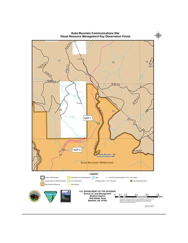
themselves as representatives or officials of organizations or businesses will be made available for public
inspection and disclosure in their entirety.

Further information on this proposed project is available at the Medford District Office, 3040 Biddle
Road, Medford, Oregon 97504 or by calling Kathy Minor, Lead Planning and Environmental
Coordinator, at 541-618-2245.

                                                   Ashland Resource Area

Enclosure
UNITED STATES DEPARTMENT OF THE INTERIOR
                        BUREAU OF LAND MANAGEMENT
                              MEDFORD DISTRICT

                                      EA COVER SHEET

RESOURCE AREA:                    Ashland

RESPONSIBLE OFFICIAL:             Jennifer Sanborn, Acting Field Manager
                                  Medford District Bureau of Land Management
                                  Ashland Resource Area
                                  3040 Biddle Road
                                  Medford, OR 97504

ACTION/TITLE:                     New Cingular Wireless PCS, LLC (AT&T)
                                  Right-Of-Way Grant Renewal (OR 48563)

EA NUMBER:                        DOI-BLM-OR-M040-2013-002-EA

LOCATION: The project area is located within the Soda Mountain Communications Site in the
Cascade-Siskiyou National Monument. The Public Land Survey System (PLSS) description is
the NW¼ of Section 28, T. 40 S., R. 3 E., Willamette Meridian, Jackson County, Oregon. The
right-of-way grant includes New Cingular Wireless PCS, LLC (AT&T)’s communication facility
at the top of Soda Mountain and the use and maintenance of BLM roads 39-3E-32.3 (Soda
Mountain Road), 40-3E-21.1 and 40-3E-21.2 (Soda Mountain Lookout Road).

      List of Preparers            Responsibility
      Kathy Minor                  IDT Lead, NEPA Compliance, Hydrology, GIS
      Tanya Dent                   Project Lead, Lands and Realty
      Sasha Joachims               Botanical Resources, Special Status Plants, Weeds
      Lisa Rice                    Cultural Resources
      Chris Volpe                  Hydrology/Fishery Resources
      Ginelle O’Conner             Wildlife Resources
      Zach Million                 Recreation/Visual Resources
      Michelle Calvert             NEPA Compliance, Editing

                                                i
ii
TABLE OF CONTENTS
CHAPTER 1 – PURPOSE AND NEED ................................................................................................... 1
   INTRODUCTION .................................................................................................................................... 1
   BACKGROUND ...................................................................................................................................... 1
   PURPOSE AND NEED ............................................................................................................................ 3
   PROPOSED ACTION .............................................................................................................................. 3
   DECISION FRAMEWORK ..................................................................................................................... 4
   LAND USE CONFORMANCE AND LEGAL REQUIREMENTS ........................................................ 8
   RELEVANT ASSESSMENTS AND PLANS........................................................................................ 10
   SCOPING ............................................................................................................................................... 12
   RELEVANT ISSUES ............................................................................................................................. 12
CHAPTER 2 - ALTERNATIVES .......................................................................................................... 15
   INTRODUCTION .................................................................................................................................. 15
           Alternative 1 – No Action .............................................................................................................. 15
   THE ACTION ALTERNATIVES .......................................................................................................... 15
           Alternative 2 – Proposed Action .................................................................................................... 15
           Alternative 3 ................................................................................................................................. 16
   PROJECT DESIGN FEATURES ........................................................................................................... 17
   ALTERNATIVES CONSIDERED BUT ELIMINATED FROM DETAILED ANALYSIS ................ 18
CHAPTER 3 – AFFECTED ENVIRONMENT AND ENVIRONMENTAL CONSEQUENCES ... 20
   INTRODUCTION .................................................................................................................................. 20
   GENERAL SETTING ............................................................................................................................ 20
   FORESEEABLE ACTIONS................................................................................................................... 21
   RECREATION, VISUAL RESOURCES AND WILDERNESS CHARACTER.................................. 23
   BOTANICAL RESOURCES ................................................................................................................. 30
   WILDLIFE RESOURCES...................................................................................................................... 35
CHAPTER 4 – PUBLIC PARTICIPATION ......................................................................................... 38
GLOSSARY .............................................................................................................................................. 39
REFERENCES ......................................................................................................................................... 41

                                                                            iii
iv
CHAPTER 1 – PURPOSE AND NEED
INTRODUCTION
The Bureau of Land Management (BLM), Ashland Resource Area, is evaluating an application
from New Cingular Wireless PCS, LLC (AT&T) to renew an existing right-of-way (ROW) grant
(OR 48563) for their communication facility located at the top of Soda Mountain in the Cascade-
Siskiyou National Monument (CSNM) and associated rights to use and maintain BLM roads 39
3E-32.3 (Soda Mountain Road), 40-3E-21.1 and 40-3E-21.2 (Soda Mountain Lookout Road).
This Environmental Assessment (EA) documents the environmental analysis conducted to
estimate the site-specific effects on the human environment that may result from the renewal of
the right-of-way grant to New Cingular Wireless PCS, LLC (AT&T) on BLM-administered
lands. The analysis documented in this EA will provide the BLM’s responsible official, the
Ashland Resource Area Field Manager, with current information to aid in the decision-making
process. This document complies with the Council on Environmental Quality’s (CEQ)
Regulations for Implementing the Procedural Provisions of the National Environmental Policy
Act (NEPA; 40 CFR Parts 1500-1508) and the Department of the Interior’s manual guidance on
the National Environmental Policy Act of 1969 (43 CFR part 46).
This chapter cites management direction, and displays the decisions to be made in analyzing this
proposal. It defines the scope of the analysis, summarizes the scoping process, and describes the
issues identified during scoping.
BACKGROUND
The Soda Mountain Communications Site is located on public land and administered by the
Bureau of Land Management, Medford District Office (Map 1). It is a long-standing, established
site that serves a large and varied population over a broad geographic region encompassing
southwest Oregon and northern California. Soda Mountain functions as a vital link in the
communications industry. The various authorized holders who currently operate at the site
provide an array of services, including emergency 911 service; fire detection/reporting;
commercial and public radio and television broadcasting; microwave and internet data links;
telephone transmissions; and other uses.
The site overlooks Ashland, Oregon and several other communities in the region. Interstate 5
runs in a generally north/south direction approximately six miles west of the communications
site. State Highway 66 runs in an east/west direction approximately four miles north of Soda
Mountain. Other secondary county and BLM roads also run through the surrounding area. This
transportation network, and the many residents who live in and around the area (including those
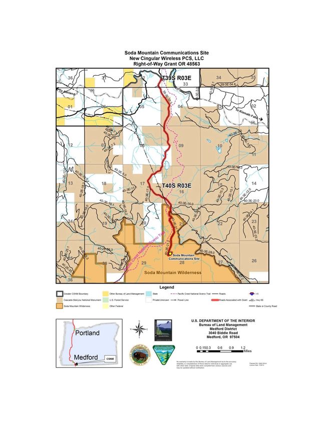
1Map 1. Vicinity Map
Soda Mountain Communications Site
New Cingular Wireless PCS, LLC
Right-of-Way Grant OR 48563
29 26
Soda Mountain Wilderness
Legend
[ ] Gteater CSNM Boundary Other Bureau of Land Menagement - - - Pllcillc Crest NatiO'III Scenic Trail - Roeds .......
Cesetd•Sisk~ou Nlltion-' Monument uS ForestSMvlc:e Prlwte/Unknown - - Pofier une ~011d1 Associated with Gt.nt -8:a Hwy 66
0 Soda Mountain Wikfemess Olher Federal = ~te a County Reed
U.S. DEPARTMENT OF THE INTERIOR
•• •
Bureau of Land Management
Medford District
3040 Biddle Road
s Medford, OR 97504
v 0 0.150.3 06
-=::-==---==:::~-- Miles
09
KOw..,....,ty•.- ttr . . ..._uOI'l-M•....,.._niO-ac:c"r.qo
. ,....
,....,.YOfQOIII.to6ti.-OIMS•4*10t"'within the boundaries of the CSNM), are served by the authorized users who operate at and
provide 24/7 communication services from the top of Soda Mountain.
There are currently eight communications facilities at Soda Mountain. The first authorized use
on the mountain was for the fire lookout/repeater site, allowed through a letter of permission
dated May 11, 1962. Medford Cellular Telephone Company, Inc. (now New Cingular Wireless
PCS, LLC) was authorized on September 30, 1992. The last communications facility to be
authorized on Soda Mountain occurred on September 6, 1993.
In 2000, the Cascade-Siskiyou National Monument was reserved in recognition of its remarkable
ecology and to protect a diverse range of biological, geological, aquatic, archeological and
historic objects (Presidential Proclamation 7318). The Soda Mountain Wilderness (SMW) was
added to the National Wilderness Preservation System on March 30, 2009. The Soda Mountain
Communications Site is within the CSNM and is surrounded on all sides by the SMW.
The existing New Cingular Wireless PCS, LLC (AT&T) communication site authorization at
Soda Mountain was recognized as a valid existing right in the Cascade-Siskiyou National
Monument Record of Decision and Resource Management Plan (USDI 2008, VER-5, p. 117 and
Appendix O, Table O-2, p. O-3). The CSNM ROD/RMP also identified that a comprehensive
communications site management plan addressing site efficiency, visual resources, and the
impacts of technology would be developed (VER-6, p. 117). The Soda Mountain
Communications Site Management Plan was approved on August 27, 2012.
PURPOSE AND NEED
The purpose of BLM’s action is to respond to New Cingular Wireless PCS, LLC (AT&T)’s
application to renew their communication facility right-of-way grant on BLM-administered lands
by granting, granting with conditions, or denying the application. Pursuant to 43 CFR § 2805.10,
if the BLM issues a grant, the BLM may include terms, conditions, and stipulations that the
BLM determines to be in the public interest.
PROPOSED ACTION
This section provides a brief summary of the BLM’s proposal for responding to an application
from New Cingular Wireless PCS, LLC (AT&T) to renew their communication site right-of-way
grant (OR 48563). A more detailed description of the Proposed Action (Alternative 2) and other
alternatives considered is included in Chapter 2, Alternatives.
The BLM is proposing to renew New Cingular Wireless PCS, LLC (AT&T)’s right-of-way grant
for a period of 10 years, and to include modifications to the original grant to address special
resource considerations associated with the CSNM and adjacent resource values associated with
the SMW. The right-of-way grant would authorize New Cingular Wireless PCS, LLC (AT&T)
3to operate and maintain their existing communication facility and use and maintain BLM roads
39-3E-32.3 (Soda Mountain Road), 40-3E-21.1 and 40-3E-21.2 (Soda Mountain Lookout Road)
as shown on Map 1.
Proposed modifications to the existing facilities would not exceed the current tower height or
building footprint. An existing 4-foot diameter microwave dish located 50 feet high on the tower
would be removed and replaced with a 2.5-foot diameter microwave dish at 80 feet on the tower.
A new 6-foot diameter microwave dish with an ice shield would be placed at 70 feet on the
existing tower.
The equipment shelter, coax cable bridge, propane tank, and all microwave dishes and ice shields
would be painted with shadow gray paint (from the BLM Standard Environmental Color Chart
(2008)) to better blend with the natural background and minimize the visual contrast of the
facility in the landscape.
The two existing subleases (AT&T and the State of Oregon) would continue per their existing
agreement with the right-of-way holder (New Cingular Wireless PCS, LLC (AT&T)). If either
sublease agreement is terminated, no new subleases would be allowed.
DECISION FRAMEWORK
This Environmental Assessment will provide the information needed for the responsible official,
the Ashland Resource Area Field Manager, to select a course of action to be implemented in
response to the request from New Cingular Wireless PCS, LLC (AT&T) to renew their
communications lease on Soda Mountain. The Ashland Resource Area Field Manager must
decide whether to implement one of the action alternatives, select the No Action Alternative, or
choose a combination of components found within those alternatives analyzed.
The decision will also include a determination of whether or not the impacts of the Proposed
Action are significant to the human environment. If the impacts are determined to be
insignificant, a Finding of No Significant Impact (FONSI) can be issued and a decision
implemented. If this EA determines that the significance of impacts are unknown or greater than
those previously analyzed and disclosed in the RMP/FEIS then a project specific environmental
impact statement (EIS) must be prepared.
In choosing the alternative that best meets the needs/objectives, the Field Manager will consider
the extent to which each alternative responds to the decision factors listed below. The
forthcoming Decision Record will document the authorized officer’s rationale for selecting a
course of action based on the effects documented in the EA, and the extent to which each
alternative:
4Is consistent with the management direction in the Cascade-Siskiyou National Monument
Record of Decision and Resource Management Plan (USDI 2008) for communication sites.
The 2008 CSNM ROD/RMP contains the following direction for the overall management of the
Soda Mountain Communications Site:
The proclamation states, “The establishment of this monument is subject to valid existing
rights.” Valid existing rights (VERs) may include a variety of BLM authorizations such
as rights-of-way grants, leases, reciprocal agreements, and withdrawals. Valid existing
rights were expressly recognized and protected in the presidential proclamation (USDI
2008, p. 114). The existing New Cingular Wireless PCS, LLC (AT&T) communication
site authorization at Soda Mountain was recognized as a valid existing right in the CSNM
ROD/RMP (USDI 2008, VER-5, p. 117 and Appendix O, Table O-2, p. O-3).
VER-5: Existing communication site authorizations on Soda Mountain… will continue.
No new facilities would be built at the existing communication sites. Modifications to
existing individual facilities (i.e., buildings) can be made if the proposed use does not
increase the size (footprint) of the current authorized development and there are no
interference problems with the other authorized users. For example, the addition or
replacement of a new transmitting or receiving device (e.g., antenna) on an existing tower
structure would be considered if the proposed device was consistent with the other
existing electronic devices in terms of size, visual characteristics, and frequency
compatibility.
VER-6: The BLM completed a communication site survey for the Soda Mountain site in
2005. A comprehensive communication site management plan addressing site efficiency,
visual resources, and impacts of new technology is planned for 2006 (dependent on
funding). The BLM could permit modifications, such as a new device, following the
completion of a site-specific management plan.
VER-7: The Soda Mountain communication site access roads (40-3E-21.1, 40-3E-21.2)
will be improved (rocked) to reduce erosion, maintained to BLM standards, and gated at
the junction of 40-3E-21.1 and 40-3E-21.2.
VER-8: No new communications sites will be developed in the CSNM.
Follows the guidance in the Soda Mountain Communications Site Management Plan (USDI
2012).
In accordance with the CSNM ROD/RMP (USDI 2008, VER-6, p. 117), the Soda Mountain
Communications Site Management Plan was completed in 2012. This site plan was incorporated
into all the existing leases or right-of-way grants and is required to be used in conjunction with
5the granting authorization. Provisions of the site plan are enforced through the granting
authorization (USDI 2012a, p. 10).
The Soda Mountain Communications Site Management Plan provides applicable guidance and
adds current policy and technical standards for better management of the Soda Mountain
Communications Site. The site plan provides guidance for future modification of individual
facilities at the site in conformance with the CSNM ROD/RMP. Lease terms may be modified at
the time of renewal and the leases explicitly provide for review of the lease at any time in order
to make changes that are “in the public interest.” The BLM will be reviewing New Cingular
Wireless PCS, LLC (AT&T)’s request for renewal and modification to determine if changes are
needed in order to protect the values and objects protected by the monument proclamation as
directed in the communications site plan (USDI 2012a, p. 10).
One of the goals identified in the communications site plan (USDI 2012a) is to achieve visual
quality objectives by requiring design standards that are unobtrusive and utilizing earth tone
colors and non-reflective surface material and stringent site maintenance requirements (p. 9).
Management of the appearance of the facilities at the communications site should look to the
natural features of the surrounding landscape (p. 13). On p. 16, the site management plan
requires repainting of dish antennas and covers as repairs or replacement become necessary with
a color pre-approved by BLM and limits the size of dish antennas to 8 feet diameter. Dishes are
to be mounted as low as possible. All propane tanks are to be painted an approved color to blend
in with the natural environment (p. 19).
The communications site plan sets out criteria that the applicant must follow when making
requests for renewals and or requests for modification or reconstruction. Applicants are required
to:
1. Analyze whether there are any reasonable off-monument alternatives for placement of
facilities prior to analyzing continued use within the monument;
2. Analyze any technological advancements that could obviate the need for this facility
altogether;
3. Analyze any technological advances that could reduce the footprint and the visual and
other impacts of the facility.
Considers the resource values associated with the Cascade-Siskiyou National Monument
and the adjacent Soda Mountain Wilderness.
In 2000, the Cascade-Siskiyou National Monument (CSNM) was reserved in recognition of its
remarkable ecology and to protect a diverse range of biological, geological, aquatic,
archeological and historic objects. The Soda Mountain Wilderness was added to the National
Wilderness Preservation System on March 30, 2009. The Soda Mountain Communications Site
6is within the CSNM and is surrounded on all sides by the SMW. Special resource coordination
considerations with on-site or adjacent resource values must be consistent with the CSNM
ROD/RMP (USDI 2008) and the Soda Mountain Wilderness Final Stewardship Plan (USDI
2012b). Both the CSNM and the SMW are part of the National Landscape Conservation System
(NLCS). As required under the Omnibus Public Lands Management Act of 2009, the BLM will
manage components of the NLCS to “conserve, protect, and restore nationally significant
landscapes.”
The CSNM ROD/RMP assigns Visual Resource Management (VRM) Class II to the lands of the
monument (VIS-2, page 114). The objective of Class II is to retain the existing character of the
landscape. Per BLM’s Visual Resource Inventory Handbook, H-8410-1 (V)(B)(2),
“management activities may be seen, but should not attract the attention of the casual observer.”
Any changes made in lands with VRM Class II management objective “must repeat basic
elements of form, line, color, and texture found in the predominant natural features of the
characteristic landscape.” Management of the appearance of the facilities at the communications
site should look to the natural features of the surrounding landscape.
Is consistent with the management direction in BLM Manual 6100 – National Landscape
Conservation System Management Manual (USDI 2012c), BLM Manual 6220 – National
Monuments, National Conservation Areas, and Similar Designations (USDI 2012d) and BLM
Manual 6340 – Management of BLM Wilderness (USDI 2012e).
The CSNM and SMW are part of the National Landscape Conservation System (NLCS). NLCS
units include National Monuments, National Conservation Areas and Similar Designations,
Wilderness, Wilderness Study Areas, Wild and Scenic Rivers, and National Scenic and Historic
Trails. As specified in the Omnibus Public Land Management Act of 2009 (16 U.S.C. 7202), the
NLCS was established in order to “conserve, protect and restore nationally significant landscapes
that have outstanding cultural, ecological, and scientific values…” NLCS units are to be
managed “in a manner that protects the values for which the components of the system were
designated.” BLM Manual 6100 (USDI 2012c) provides general policy on managing public
lands (also referred to as National Conservation Lands) in the NLCS. The BLM has additional
manuals addressing policy specific to individual NLCS units.
BLM Manual 6100 (Section 1.6.I.1) states that subject to valid existing rights, the BLM will
consider removal of facilities from National Conservation Lands that do not have administrative,
public safety, recreational, cultural or historic value. Section 1.6.I.5 indicates that facilities
within NLCS units will be designed and sited in a manner that minimizes impacts to NLCS
values.
Management direction related to existing communications sites within monuments is provided in
BLM Manual 6220 (USDI 2012d). BLM Manual 6220 (Section 1.6.A.4) provides that “to the
7greatest extent possible, and in accordance with applicable law, valid existing rights and other
non-discretionary uses will be managed to mitigate impacts to objects and values for which the
Monuments and NCAs were designated.”
The manual also directs BLM “to consider removal of facilities on Monuments or NCAs that do
not have administrative, public safety, recreational, cultural or historic value (Section 1.6.F.1)”
and “While processing ROW renewals, in accordance with all applicable law and policy, the
BLM should work with holders of existing ROWs to consider new, additional, or modified terms
and conditions to minimize impacts to the Monument or NCA values (Section 1.6.E. 6).”
Whenever possible, the BLM will seek opportunities for relinquishment of existing leases,
minimize the footprint of the existing facilities, and require that technological improvements and
alternative sites be considered that seek to reduce the impacts and potentially replace the
communication equipment at the site.
BLM Manual 6340 - Management of BLM Wilderness (USDI 2012e) provides the following
guidance, “In general, BLM does not prohibit uses outside a wilderness on public lands solely to
protect wilderness character of the designated lands.” When activities are proposed on public
lands adjacent to wilderness, such as lease renewals or facility modification requests at the
communications site, “the potential impacts, if any, of those activities upon the wilderness
resource and upon public use of the adjacent wilderness area must be analyzed in the applicable
NEPA document (Section 1.6.D.2.a.).” The BLM may require actions to mitigate impacts to
adjacent wilderness (such as using certain paint schemes on equipment) as identified through the
NEPA process (Section 1.6.D.2.b.) if they do not impose undue financial burden on the operator.
Maintains vital communication coverage (including emergency 911 services) to the
surrounding area.
The New Cingular Wireless PCS, LLC (AT&T) communication facility provides wireless
communication and emergency 911 services for the surrounding area. The site is a crucial
location for covering traffic on Interstate 5 in an area with very little wireless coverage. The site
serves several Ranally Metro Areas (RMAs). The largest population zone served by this site is
Medford, OR, with a population of 100,000 to 299,999 (Zone 6).
LAND USE CONFORMANCE AND LEGAL REQUIREMENTS
CONFORMANCE WITH LAND USE PLANS
This right-of-way grant proposal is designed to be in conformance with the Cascade-Siskiyou
National Monument (CSNM) Record of Decision (ROD) and Resource Management Plan
(RMP) (USDI 2008), as amended (USDI 2013). The CSNM ROD/RMP incorporates by
reference portions of the Northwest Forest Plan (NFP) (USDA/USDI 1994a), as amended, and
the Medford District RMP (USDI 1995) as they are consistent with the presidential
8proclamation. The analysis supporting this decision tiers to the Cascade-Siskiyou National
Monument Proposed Resource Management Plan/Final Environmental Impact Statement (USDI
2005).
CONSULTATION
Consultation under the Endangered Species Act with the USFWS is not necessary. The right-of
way grant renewal would have no effect on listed species or their habitat.
There would be no affected to listed aquatic species nor their habitat, and consultation with the
National Oceanic and Atmospheric Administration (NOAA) Fisheries is not needed.
Consultation for federally-listed botanical species was not needed as the Soda Mountain
Communication Site is outside the range of any federally-listed botanical species.
Letters describing the preliminary Proposed Action initiating consultation with the local
federally recognized Native American Tribes were sent in November 2014. Further consultation
in the form of meetings, phone calls, and emails did not identify any concerns with the proposed
activities.
Consultation with the State Historic Preservation Office (SHPO) was not needed as the BLM
determined that the project will have “no effect” to cultural resources.
SPECIAL STATUS SPECIES
The New Cingular Wireless PCS, LLC (AT&T) right-of-way grant request is consistent with
BLM Manual 6840 (USDI 2008), the purpose of which is to provide policy and guidance for the
conservation of BLM Special Status Species and the ecosystems upon which they depend on
BLM-administered lands. BLM Special Status Species include those species listed or proposed
for listing under the Endangered Species Act (ESA), as well as those designated as Bureau
Sensitive by the State Director. The objectives of the BLM Special Status policy are:
• To conserve and/or recover ESA-listed species and the ecosystems on which they depend
so that ESA protections are no longer needed for these species; and
• To initiate proactive conservation 1 measures that reduce, or eliminate, threats to Bureau
Sensitive species to minimize the likelihood of and need for listing of these species under
the ESA (USDI 2008, Section .02).
1
Conservation: as applied to Bureau Sensitive species, is the use of programs, plans, and management practices to
reduce or eliminate threats affecting the status of the species, or improve the condition of the species’ habitat on
BLM-administered lands (USDI 2008, Glossary p. 2).
9STATUTES AND REGULATIONS
The Proposed Action is designed to be in conformance with the direction given for the
management of public lands in the Medford District and the following:
• Oregon and California Lands Act of 1937 (O&C Act). Requires the BLM to manage O&C
lands for permanent forest production. Timber shall be sold, cut, and removed in accordance
with sustained-yield principles for the purpose of providing for a permanent source of timber
supply, protecting watersheds, regulating stream flow, contributing to the economic stability of
local communities and industries, and providing recreational facilities.
• Federal Land Policy and Management Act of 1976 (FLPMA). Defines BLM’s organization
and provides the basic policy guidance for BLM’s management of public lands.
• National Environmental Policy Act of 1969 (NEPA). Requires the preparation of
environmental impact statements for major federal actions which may have a significant effect
on the environment.
• Endangered Species Act of 1973 (ESA). Directs Federal agencies to ensure their actions do
not jeopardize species listed as “threatened and endangered” or adversely modify designated
critical habitat for these listed species.
• Clean Air Act of 1990 (CAA). Provides the principal framework for national, state, and local
efforts to protect air quality.
• National Historic Preservation Act of 1966 as amended (NHPA). Requires federal agencies
to take into account the effect of their federal or federally-licensed undertakings on historic
properties, whether those properties are federally owned or not.
• Archaeological Resources Protection Act of 1979 (ARPA). Protects archaeological
resources and sites on federally-administered lands. Imposes criminal and civil penalties for
removing archaeological items from federal lands without a permit.
• Safe Drinking Water Act (SDWA) of 1974 (as amended in 1986 and 1996). Protects public
health by regulating the nation’s public drinking water supply.
• Clean Water Act of 1987 (CWA). Establishes objectives to restore and maintain the chemical,
physical, and biological integrity of the nation’s water.
RELEVANT ASSESSMENTS AND PLANS
The following documents contain information related to existing conditions and management
practices associated with the Soda Mountain Communications Site and the surrounding area.
These documents are incorporated by reference into the project documentation.
10Soda Mountain Communications Site Management Plan (USDI 2012a)
In accordance with the CSNM ROD/RMP (USDI 2008, VER-6, p. 117), the Soda Mountain
Communications Site Management Plan was completed in 2012. This site plan was incorporated
into all the existing leases or right-of-way grants and is required to be used in conjunction with
the granting authorization.
The site plan provides applicable guidance and adds current policy and technical standards for
better management of the Soda Mountain Communications Site. It also plan provides guidance
for future modification of individual facilities at the site in conformance with the CSNM
ROD/RMP.
Soda Mountain Wilderness Final Stewardship Plan (USDI 2012b)
The Soda Mountain Wilderness was added to the National Wilderness Preservation System by
the Omnibus Public Land Management Act of 2009 (Public Law 111-11, March 30, 2009). The
SMW Final Stewardship Plan provides the primary guidance for managing the Soda Mountain
Wilderness. The plan 1) identifies the conditions and opportunities which will be managed
within the wilderness; 2) creates specific guidance for managing the resources and activities
existing in the wilderness; and 3) preserves the area’s wilderness characteristics cumulatively
identified as untrammeled quality, outstanding opportunities for solitude or a primitive form of
recreation, undeveloped character, and naturalness and primeval character.
Southwest Oregon Fire Management Plan (ODF 2014)
The Southwest Oregon Fire Management Plan (FMP) provides Southwest Oregon with an
integrated concept for coordinated wildland fire planning and protection among federal, state,
local government entities and citizen initiatives. The Fire Management Plan is not a decision
document.
The FMP introduces fire management concepts addressing fire management activities in relation
to resource objectives stated in the current land and resource management plans or land use plans
(parent documents) of the federal agencies, the laws and statutes that guide the state agencies and
private protective associations, and serves as a vehicle for local agencies and cooperators to more
fully coordinate their participation in relation to those activities.
Soda Mountain Wilderness Fire Suppression Information and Specific Action Plan (USDI
and ODF 2015)
This plan provides guidance for all fire suppression activities within the Soda Mountain
Wilderness. It includes fire suppression guidance from BLM Manual 6340 – Management of
BLM Wilderness Section 1.6.C.7 (USDI 2012e). It is updated annually and includes delegation
of authority, dispatch procedures, and identifies resource advisors for the SMW.
11SCOPING
Scoping is the process the BLM uses to identify issues related to the proposal (40 CFR 1501.7)
and determine the extent of environmental analysis necessary for an informed decision. It is
used early in the NEPA process to identify (1) the issues to be addressed, (2) the depth of the
analysis, (3) alternatives or refinements to the Proposed Action, and (4) potential environmental
impacts of the Proposed Action. Scoping is performed not to build consensus or get agreement
on a project proposal, but rather to solicit relevant site-specific comments that could aid in the
analysis and final design of the proposal.
Scoping has occurred for the New Cingular Wireless PCS, LLC (AT&T) Right-of-Way Grant
Project (OR 48563). The New Cingular Wireless (AT&T) Project appeared in the Ashland
Resource Area’s Schedule of Proposed Actions published in Medford’s Messenger (BLM’s
quarterly newsletter) beginning in the winter 2012-2013 edition. A letter briefly describing the
Proposed Action and inviting comments was mailed to adjacent landowners, interested
individuals, organizations, and other agencies and posted on the Medford BLM planning website
on January 22, 2013. The BLM received two scoping comment letters.
RELEVANT ISSUES
An interdisciplinary (ID) team of resource specialists reviewed the renewal proposal and all
pertinent information, including public input received, and identified relevant issues to be
addressed during the environmental analysis.
Re-authorization of the New Cingular Wireless PCS, LLC (AT&T) right-of-way grant has
the potential to impact the protection of the objects of biological interest for which the
CSNM was designated (Presidential Proclamation 7318).
The presidential proclamation reserved the CSNM in recognition of its remarkable ecology and
to protect a diverse range of biological, geological, aquatic, archaeological and historic objects.
The communication facility has the potential to impact wildlife, such as various bird species
including bluebird, meadowlark, and other species mentioned in the proclamation, as well as
archaeological and historic objects.
Re-authorization of the New Cingular Wireless PCS, LLC (AT&T) right-of-way grant may
impact the visual quality of the CSNM and the adjacent SMW and may alter the character
of the landscape.
The CSNM is assigned Visual Resource Management (VRM) Class II (USDI 2008, VIS-2, p.
114). The objective within the CSNM is to “retain the existing character of the landscape.” The
long-term management objectives for the CSNM are to preserve the natural landscape. The level
of change to the characteristic landscape should be low. Management activities may be seen, but
12should not attract the attention of the casual observer. Any changes must repeat the basic
elements of form, line, color, and texture found in the predominant natural features of the
characteristic landscape (USDI 1986, BLM Manual H-8410-1(V)(B)(2)).”
Approximately 18.8 miles of the Pacific Crest National Scenic Trail (PCNST) is located within
the CSNM. The trail allows visitors to experience scenic, historical, natural and cultural
resources within the CSNM and SMW. The Soda Mountain Communications Site is visible
from multiple locations along the trail. Renewal of the New Cingular Wireless PCS, LLC
(AT&T) right-of-way grant may affect the visual quality from the PCNST.
Re-authorization of the New Cingular Wireless PCS, LLC (AT&T) right-of-way grant has
the potential to affect wilderness character in the adjacent Soda Mountain Wilderness.
The Soda Mountain Wilderness was added to the National Wilderness Preservation System by
the Omnibus Public Land Management Act of 2009 (Public Law 111-11, March 30, 2009).
Wilderness areas provide a contrast to lands where human activities dominate the landscape.
Wilderness areas are managed for the use and enjoyment of the American people in a manner
that will leave them unimpaired for future use and enjoyment as wilderness, for their protection,
for the preservation of their wilderness character, and for the gathering and dissemination of
information regarding their use and enjoyment as wilderness.
Wilderness character is composed of four mandatory qualities and a fifth, optional quality
(Section 2(c) of the Wilderness Act of 1964), summarized as:
• Untrammeled – wilderness is unhindered and free from modern human control or
manipulation.
• Outstanding opportunities for solitude or a primitive and unconfined type of recreation –
wilderness provides opportunities for people to experience solitude or primitive and
unconfined recreation, including the values of inspiration and physical and mental
challenge.
• Undeveloped – wilderness is substantially without permanent developments or modern
human occupation.
• Natural – wilderness ecological systems, being affected primarily by the forces of nature,
retain their primeval character and influence substantially free from the effects of modern
human civilization.
• Unique/Supplemental Values – wilderness may also contain ecological, geological, or
other features of scientific, educational, scenic, or historical value.
BLM Manual 6340 - Management of BLM Wilderness (USDI 2012e) provides the following
guidance, “In general, BLM does not prohibit uses outside a wilderness on public lands solely to
protect wilderness character of the designated lands.” When activities are proposed on public
13lands adjacent to wilderness, such as lease renewals or facility modification requests at the
communications site, “the potential impacts, if any, of those activities upon the wilderness
resource and upon public use of the adjacent wilderness area must be analyzed in the applicable
NEPA document (Section 1.6.D.2.a.).” The BLM may require actions to mitigate impacts to
adjacent wilderness (such as using certain paint schemes on equipment) as identified through the
NEPA process (Section 1.6.D.2.b.) if they do not impose undue financial burden on the operator.
Allowing new users to sublease and co-locate with New Cingular Wireless PCS, LLC
(AT&T) may incrementally increase the infrastructure in the area causing the condition of
the area to become more developed and less natural in conflict with the proclamation and
other laws and regulations mandating protection of public lands in the area.
The Soda Mountain Communications Site Plan states that new users on the Soda Mountain
Communications Site will be required to co-locate within existing facilities in which the
particular right-of-way authorization includes a subleasing provision that enables them to do so
(USDI 2012a, p. 12). The original right-of-way grant for New Cingular Wireless PCS, LLC
(AT&T)’s communication facility (OR 48563) allowed for subleasing of the facility. There are
currently two existing subleases (AT&T and the State of Oregon) associated with the right-of
way grant OR 48563. Allowing additional subleasing under the proposed right-of-way grant has
the potential to increase the infrastructure at the facility and affect CSNM and adjacent SMW
resources and values.
14CHAPTER 2 - ALTERNATIVES
INTRODUCTION
This chapter describes the Proposed Action and alternatives developed by the BLM to achieve
the objectives identified in the Purpose and Need section in Chapter 1. A “No-Action”
Alternative is presented to form a baseline for analysis. Project Design Features (PDFs) are
specific measures developed by the interdisciplinary team to eliminate or minimize adverse
impacts from the action alternatives. The PDFs apply the guidance of the 2008 Cascade-
Siskiyou National Monument Resource Management Plan.
Alternative 1 - No Action
New Cingular Wireless PCS, LLC (AT&T)’s right-of-way grant would not be renewed under
this alternative. The lessee would cease to provide communication services from the Soda
Mountain Communications Site. All improvements associated with right-of-way grant OR 48563
would be removed from public lands within 120 days, including those associated with the two
subleases.
THE ACTIONS ALTERNATIVES
This section describes the two action alternatives considered in detail. The Soda Mountain
Communications Site Management Plan was incorporated into all the existing leases or right-of
way grants and is required to be used in conjunction with the granting authorization. Provisions
of the site plan are enforced through the granting authorization (USDI 2012a, p. 10).
The site plan provides applicable guidance and adds current policy and technical standards for
better management of the Soda Mountain Communications Site. The site plan provides guidance
for future modification of individual facilities at the site in conformance with the CSNM
ROD/RMP. Lease terms may be modified at the time of renewal and the leases explicitly
provide for review of the lease at any time in order to make changes that are “in the public
interest.”
Alternative 2 - Proposed Action
The Proposed Action would renew the New Cingular Wireless (AT&T) right-of-way grant, as
amended by the Soda Mountain Communications Site Management Plan (USDI 2012a) with
modifications to address the objectives described in Chapter 1, the Purpose and Need for the
proposed right-of-way grant.
15The BLM is proposing to renew New Cingular Wireless PCS, LLC (AT&T)’s right-of-way grant
for 10 years, and to include modifications to the original grant to address special resource
considerations associated with the CSNM and adjacent resource values associated with the
SMW. The BLM is proposing a 10-year lease instead of the requested 30-year period because it
is foreseeable that by 2025, communications technology will have advanced enough to make off-
site or a reduced-size facility feasible.
The right-of-way grant would authorize New Cingular Wireless PCS, LLC (AT&T) to operate
and maintain their existing communication facility and use and maintain BLM roads 39-3E-32.3
(Soda Mountain Road), 40-3E-21.1 and 40-3E-21.2 (Soda Mountain Lookout Road). The lease
would be for a 100-foot x 100-foot compound containing an operational 80-foot cell tower,
equipment shelter, a propane tank.
Proposed modifications to the existing facilities would not exceed the current tower height or
building footprint. An existing 4-foot diameter microwave dish located 50 feet high on the tower
would be removed and replaced with a 2.5-foot diameter microwave dish at 80 feet on the tower.
A new 6-foot diameter microwave dish with an ice shield would be placed at 70 feet on the
existing tower.
The equipment shelter, coax cable bridge, propane tank, and all microwave dishes and ice shields
would be painted with shadow gray paint (from the BLM Standard Environmental Color Chart
(2008)) to better blend with the natural background and minimize the visual contrast of the
facility in the landscape. Peeling paint on buildings and/or towers would be required to be re
painted within 30 days of discovery by the facility owner or facility manager and within 10 days
of notification of the holder by the BLM, weather permitting (USDI 2012a, p.20).
The two existing subleases (AT&T and the State of Oregon) would continue per their existing
agreement with the right-of-way holder (New Cingular Wireless PCS, LLC (AT&T)). No
additional subleases would be allowed. If either sublease agreement is terminated by the right-
of-way holder or voluntarily relinquished by the tenant or customer, no replacement subleases
would be permitted.
Because mergers, buy-outs, and name changes are common in the communication industry, this
right-of-way grant would be re-assignable in these specific instances.
Alternative 3
Under Alternative 3, BLM would renew the New Cingular Wireless (AT&T) current lease, as
amended by the Soda Mountain Communications Site Management Plan (USDI 2012a) with a
minor correction to the description of the access to the site. The original right-of-way grant
included the rights to use and maintain BLM Roads 39-3E-32.3 (Soda Mountain Road) and Road
40-3E-21.1. The map associated with the original right-of-way was correct; however, the road
16numbers were misidentified. Road 40-3E-21.1 takes off from the Soda Mountain Road (39-3E
32.3) towards the communications site, but forks off into the SMW at its junction with Road 40
3E-21.2. Road 39-3E-21.2 continues on up to the communications site. Under this alternative,
rights to use and maintain BLM roads 39-3E-32.3 (Soda Mountain Road), 40-3E-21.1 and 40
3E-21.2 (Soda Mountain Lookout Road) as shown on Map 1 would be granted.
The current (expired) lease is for a 100-foot x 100-foot compound containing an operational 80
foot cell tower, equipment shelter, a propane tank, and access to the site as described above, for a
period of 20 years. It includes a provision that allows the holder to issue subleases to other users
of the facility for communication purposes. The current right-of-way grant also requires that all
structures be painted with non-reflective, earth-tone colors.
PROJECT DESIGN FEATURES
Project Design Features (PDFs) are an integral part of the action alternatives (Alternatives 2 and
3). They are developed to avoid or reduce the potential for adverse impacts to resources. PDFs
include seasonal restrictions on certain activities in order to minimize erosion and reduce
disturbance to wildlife. Where applicable, PDFs reflect standard operating procedures.
PDFs included in this project description are carried forward into the right-of-way grant as terms
and conditions. The BLM will monitor the operations of the right-of-way holder to ensure that
terms and conditions are implemented as designed. The PDFs listed below apply to both
Alternative 2 (Proposed Action) and Alternative 3.
• Should a new spotted owl nest be discovered within 200 feet of BLM Road 40-3E-21.2, a
seasonal restriction would be imposed for chainsaw use along the shoulder of the road to
reduce disturbance during the nesting season (March 1- September 30).
• A seasonal restriction would be necessary if a new great gray owl nest is located adjacent
to the right-of-way authorization.
• To prevent the spread of noxious weeds, all heavy equipment used for maintenance and
installation of any approved modifications would be washed prior to entering BLM lands
and free of mud and debris.
• Highly disturbed areas will be seeded, re-vegetated, and/or mulched as requested by the
resource area botanist. Only certified weed-free mulch and/or native seed will be used.
• If the right-of-way holder encounters or becomes aware of any objects or sites of
paleontological or cultural value on federal lands, such as fossils, historical or pre
historical ruins, graves, grave markers, or artifacts, the contractor shall immediately
suspend all operations in the vicinity of the cultural value and notify the Authorized
Officer of the findings. The Authorized Officer may require measures to protect the
17cultural resource values present, or require evaluation and mitigation procedures based on
recommendations from the BLM archaeologist with concurrence by the Ashland Field
Manager and State Historic Preservation Office.
ALTERNATIVES CONSIDERED BUT ELIMINATED FROM DETAILED ANALYSIS
NEPA requires that federal agencies explore all reasonable alternatives, and briefly discuss the
reasons for eliminating any alternatives that were explored but not developed in detail (40 CFR
1502.14 (a)). The following alternatives or actions have been considered but eliminated from
detailed study.
Facility Relocation or Footprint Reduction
The Soda Mountain Communications Site Management Plan sets out criteria that the applicant
must follow when making requests for renewals and or requests for modification or
reconstruction (USDI 2012a, p. 22). Applicants are required to:
1. Analyze whether there are any reasonable off-monument alternatives for placement of
facilities prior to analyzing continued use within the monument;
2. Analyze any technological advancements that could obviate the need for this facility
altogether;
3. Analyze any technological advances that could reduce the footprint and the visual and
other impacts of the facility.
New Cingular Wireless PCS, LLC (AT&T) explored the possibility of relocating their facility
off-monument and considered advances in technology which could reduce the footprint or
eliminate the need for the Soda Mountain location. Based on their analysis, they determined that
it is not feasible or practical for New Cingular Wireless PCS, LLC (AT&T) to relocate their
facilities to another mountain top.
There are no reasonable off-monument alternatives to relocate their facilities and still meet the
necessary coverage objectives required by New Cingular Wireless PCS, LLC (AT&T). This site
provides a crucial location for covering traffic on Interstate 5 in an area with very little wireless
coverage. It would be very impractical and very expensive with no guarantee of a suitable
location to relocate.
There are currently no technological advances that would preclude the need for New Cingular
Wireless PCS, LLC (AT&T)’s facility on Soda Mountain. Current technologies have not
replaced the need for a site at this location, which satisfies New Cingular Wireless PCS, LLC
(AT&T)’s coverage objectives.
There are no technological advancements at this time that could reduce the footprint of the
current facilities without removing equipment that is necessary to the operation of the facility.
18New equipment is not significantly smaller in size than the equipment that is currently being
used.
Right-of-Way Grant Renewal for a 30-Year Term
An alternative that would authorize a right-of-way grant for a term of 30 years as requested by
New Cingular Wireless PCS, LLC (AT&T) was considered, but eliminated from detailed
analysis because communications technology advances so rapidly that it may be possible to
reduce the facility footprint or even eliminate the need for a facility on top of Soda Mountain
prior to 30 years. Evaluating the right-of-way grant at more frequent intervals would allow
advances in technology to be captured and expedite the long-term goal of restoring the CSNM to
more natural conditions (USDI 2008, p. 20).
BLM Manual 6220 (Section 1.6.A.4) provides that “to the greatest extent possible, and in
accordance with applicable law, valid existing rights and other non-discretionary uses will be
managed to mitigate impacts to objects and values for which the Monuments and NCAs were
designated.” The manual also directs BLM “to consider removal of facilities on Monuments or
NCAs that do not have administrative, public safety, recreational, cultural or historic value
(Section 1.6.F.1)” and “While processing ROW [right-of-way] renewals, in accordance with all
applicable law and policy, the BLM should work with holders of existing ROWs to consider
new, additional, or modified terms and conditions to minimize impacts to the Monument or NCA
values (Section 1.6.E. 6).” Whenever possible, the BLM will seek opportunities for
relinquishment of existing leases, minimize the footprint of the existing facilities, and require
that technological improvements and alternative sites be considered that seek to reduce the
impacts and potentially replace the communication equipment at the site.
BLM Manual 6100 (Section 1.6.I.1) states that subject to valid existing rights, the BLM will
consider removal of facilities from National Conservation Lands that do not have administrative,
public safety, recreational, cultural or historic value. As specified in the Omnibus Public Land
Management Act of 2009 (16 U.S.C. 7202), the NLCS was established in order to “conserve,
protect and restore nationally significant landscapes that have outstanding cultural, ecological,
and scientific values…” Evaluating the right-of-way grant at an interval more frequent than 30
years may allow changes in technology to be implemented sooner to achieve these goals.
19You can also read