MARINE ENERGY TEST AREA (META) - MARINE ENERGY WALES Appendix 12.1 - Navigational Risk Assessment
←
→
Page content transcription
If your browser does not render page correctly, please read the page content below
MARINE ENERGY WALES

MARINE ENERGY TEST AREA (META)                              Appendix 12.1. - Navigational Risk Assessment

Environmental Impact Assessment

                                                EOR0730

                                  Marine Energy Test Area

                                                  Rev: 03

                                            June 03, 2019

                                                                                                            rpsgroup.com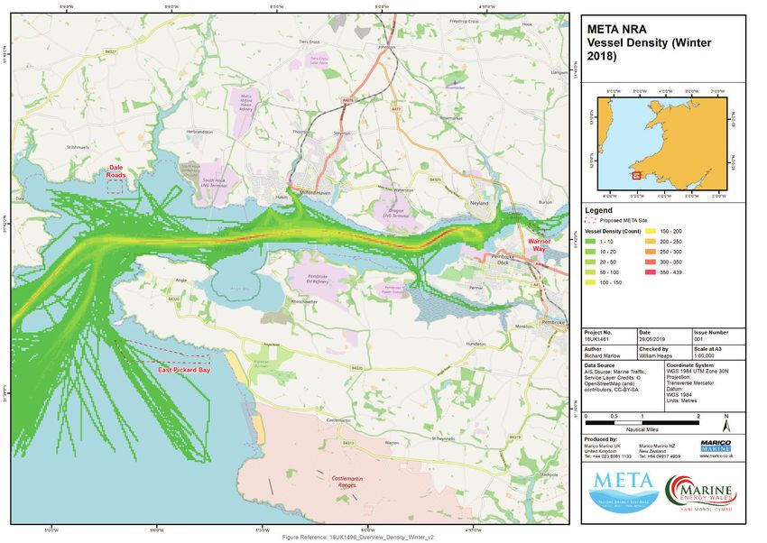
Document Status
                     Version                                                Date                                             Authored by                                         Reviewed by                                          Approved by                                           Review date

                      Rev00                                              11/03/2019                                          WH (Marico)                                                                                                                                                     11/03/2019

                      Rev01                                              17/05/2019                                          WH (Marico)                                           AC (Marico)                                          AC (Marico)                                          17/05/2019

                      Rev02                                              03/06/2019                                               AB                                              WH (Marico)                                          WH (Marico)                                           03/06/2019

                      Rev03                                              05/06/2019                                               AB                                                   AB                                                   AB                                               05/06/2019

                                                                                                                                                 Approval for issue

                                           Jessica Hooper                                                                                                                                                                                                        2019-06-03

This report was prepared by RPS Energy Ltd. (‘RPS’) within the terms of its engagement and in direct response to a scope of services. This report is strictly limited to the purpose and the facts and matters stated in it and does not apply directly or indirectly and must not be used for any other application, purpose,
use or matter. In preparing the report, RPS may have relied upon information provided to it at the time by other parties. RPS accepts no responsibility as to the accuracy or completeness of information provided by those parties at the time of preparing the report. The report does not take into account any changes
in information that may have occurred since the publication of the report. If the information relied upon is subsequently determined to be false, inaccurate or incomplete then it is possible that the observations and conclusions expressed in the report may have changed. RPS does not warrant the contents of this
report and shall not assume any responsibility or liability for loss whatsoever to any third party caused by, related to or arising out of any use or reliance on the report howsoever. No part of this report, its attachments or appendices may be reproduced by any process without the written consent of RPS. All
enquiries should be directed to RPS.

                                                                                                                   Prepared by:                                                        Prepared for:

                                                                                                               RPS Energy Ltd.                                                   Marine Energy Wales

EOR0730 | Marine Energy Test Area | Rev: 03 | June 03, 2019

rpsgroup.com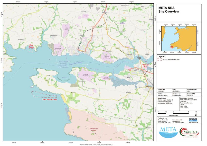
Report No: 18UK1496 -META         Commercial-in-Confidence
                                                  Issue No: 03                           META NRA

                                                                        RPS ENERGY CONSULTANTS LIMITED

                                                           MARINE ENERGY TEST AREA (META) PROJECT NRA
                                                   Prepared for:                   RPS Energy Consultants Limited

               RPS ENERGY CONSULTANTS LIMITED                                      20 Western Avenue
                                                                                   Milton Park
                                                                                   Abingdon
MARINE ENERGY TEST AREA (META) PROJECT NRA                                         Oxfordshire
                                                                                   OX14 4SH
                                                   Author(s):                      William Heaps
                                                   Checked By:                     André Cocuccio

                                                   Date            Release         Prepared          Authorised      Notes
                                                   11 Mar 2019     Draft A         WH                                Includes initial client comment
                                                                                                                     – draft for issue
                                                   27 Mar 2019     Draft B         WH                                For final client comment / QC
                                                   17 May 2019     Issue 01        WH                AC              Client Issue
                                                   03 June 2019    Issue 02        AB (RPS)          WH              Client Issue
                                                   05 June 2019    Issue 03        AB (RPS)          AB (RPS)        Client Issue

                                                                                   Marine and Risk Consultants Ltd
                                                                                   Marico Marine
                                                                                   Bramshaw
                                                                                   Lyndhurst
                                                                                   Hampshire
                                                                                   SO43 7JB
                                                                                   United Kingdom

                Report Number:   18UK1496 -META                                    Tel. + 44 (0) 2380 811133
                Issue:           03
                Date:            05 June 2019                                      05 June 2019

                                                  RPS Energy Consultants Limited                                                                     i
   MARINE AND RISK CONSULTANTS LTD
Report No: 18UK1496 -META              Commercial-in-Confidence                                               Report No: 18UK1496 -META                               Commercial-in-Confidence
Issue No: 03                                META NRA                                                          Issue No: 03                                                 META NRA

EXECUTIVE SUMMARY                                                                                                                                                                   CONTENTS
                                                                                                              Contents           iii
RPS Energy Consultants Limited (RPS) commissioned Marine and Risk Consultants Ltd (Marico Marine)
                                                                                                              Abbreviations ........................................................................................................................................viii
to undertake a Navigation Risk Assessment (NRA) for the Marine Energy Test Area (META) Project, on
behalf of Marine Energy Wales (MEW).
                                                                                                              Executive Summary ................................................................................................................................. ii
Specifically, 3 test sites for the testing of wave and tidal energy devices are proposed within and close     1        Introduction .................................................................................................................................. 1
to the Milford Haven Waterway (hereafter referred to as ‘the Waterway’). This project is closely linked       2        Study Area..................................................................................................................................... 2
to a separate project to redevelop part of Pembroke Dock (Pembroke Dock Marine) which will provide                     2.1       Scope and Methodology..................................................................................................... 4
a base port for the testing activities and therefore a joint NRA process has been undertaken for both                  2.2       Guidance............................................................................................................................. 4
projects. The META and Pembroke Dock projects are reported separately but based on the common                          2.3       MGN 543 Compliance Table ............................................................................................... 6
NRA process.                                                                                                  3        Marine Energy Test Area (META) Project ..................................................................................... 7
                                                                                                                       3.1       Overview............................................................................................................................. 7
The joint assessment was guided by the Maritime and Coastguard Agency’s (MCA’s) MGN 543
                                                                                                                       3.2       Marine Components of the Project .................................................................................... 7
standard for assessing Offshore Renewable Energy Installations (OREIs) as this provides best practice
                                                                                                                                 3.2.1 Warrior Way (Site 6)................................................................................................. 7
advice. However, as two of the META sites and the port redevelopment are situated within the
                                                                                                                                 3.2.2 Dale Roads (Site 7) ................................................................................................... 8
Statutory Harbour Authority (SHA) area of Milford Haven Port Authority (MHPA), some of the advice
                                                                                                                                 3.2.3 East Pickard Bay (Site 8) ........................................................................................... 8
in the MGN is not applicable. The MCA has advised that the MGN does not apply within SHA areas,
                                                                                                              4        Consultation.................................................................................................................................. 9
but it has been agreed that following the guidance where possible demonstrates best practice.
                                                                                                                       4.1       Consultees .......................................................................................................................... 9
The NRA has comprehensively reviewed existing traffic densities within the proposed test areas and                     4.2       Consultation Summary ..................................................................................................... 11
considered how navigation will be affected by the introduction of test devices within the three project       5        Overview of the Marine Environment ........................................................................................ 15
areas. Quantitative assessments have been undertaken for all three areas.                                              5.1       MetOcean Conditions....................................................................................................... 15
                                                                                                                       5.2       Existing Vessel Traffic Management................................................................................. 16
Existing conditions were assessed by means of assessing data including:
                                                                                                                       5.3       Search and Rescue............................................................................................................ 17
              x   AIS Traffic records for both winter and summer periods                                               5.4       Other Marine Activities .................................................................................................... 17
              x   Port Authority traffic data                                                                                    5.4.1 Marine renewable energy installations ................................................................. 17
              x   Incident data (MAIB and Port Authority)                                                                        5.4.2 Subsea Cables......................................................................................................... 17
              x   Additional traffic data (RYA, ferry schedules)                                                                 5.4.3 Anchorages............................................................................................................. 18

              x   Extensive stakeholder consultation (local groups and individuals, MHPA, MCA, Trinity                           5.4.4 Military Exercise Areas ........................................................................................... 18
                  House)                                                                                                         5.4.5 Dredging Areas and Spoil Grounds ........................................................................ 18
Current and potential future hazards were identified, as well as existing and possible future control                            5.4.6 Leisure Areas .......................................................................................................... 19
measures. All hazards assessed were scored as ALARP or Low. The operation of the test areas either            6        Existing Vessel Traffic at the Test Sites ....................................................................................... 21
individually or in combination with each other is not expected to increase the risk associated with any                6.1       Data Sources ..................................................................................................................... 21
of the identified navigation hazards to an unacceptable level, assuming all existing risk controls are                           6.1.1 AIS Derived Vessel Traffic Routes in Milford Haven .............................................. 21
maintained.                                                                                                                      6.1.2 Other Traffic Data Sources ..................................................................................... 25
                                                                                                                                 6.1.3 MHPA Data ............................................................................................................. 25
There is an opportunity to reduce risk still further, and additional risk controls have been proposed.
                                                                                                                                 6.1.4 Stakeholder Information ........................................................................................ 28

RPS Energy Consultants Limited                                                                           ii   RPS Energy Consultants Limited                                                                                                                         iii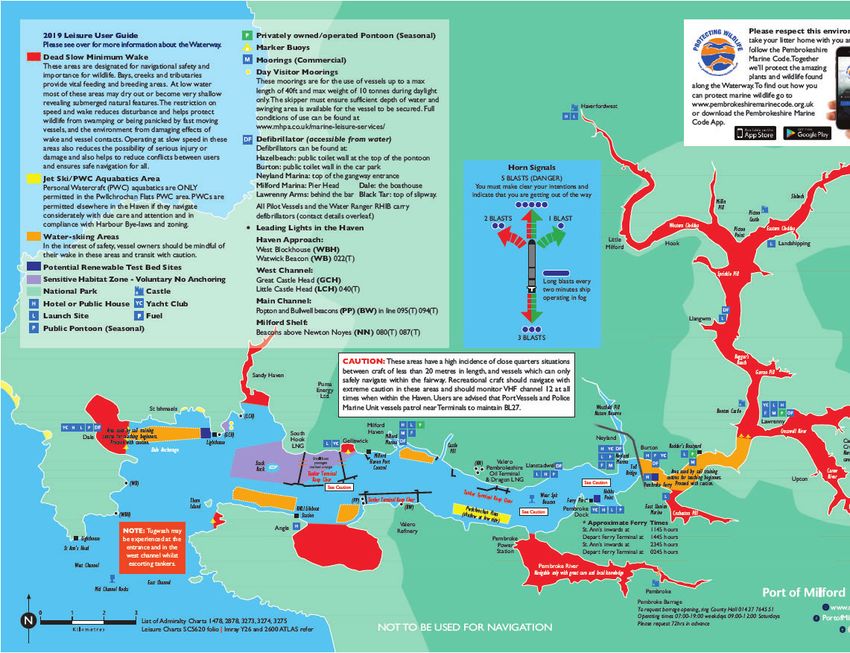
Report No: 18UK1496 -META Commercial-in-Confidence Report No: 18UK1496 -META Commercial-in-Confidence
Issue No: 03 META NRA Issue No: 03 META NRA
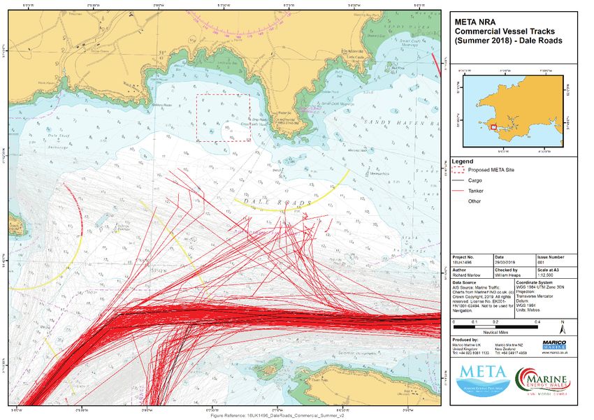
6.2 Commercial Vessels (Tanker / General Cargo) ................................................................. 29 10.3 Risk Control Options ......................................................................................................... 67
6.3 Passenger Vessels ............................................................................................................. 32 10.4 Risk Assessment ............................................................................................................... 69
6.4 Fishing Vessels .................................................................................................................. 35 10.4.1 Warrior Way ........................................................................................................... 70
6.5 Recreational Craft............................................................................................................. 38 10.4.2 Dale Roads.............................................................................................................. 71
6.6 High Speed Craft ............................................................................................................... 42 10.4.3 East Pickard Bay ..................................................................................................... 72
6.7 Tugs and Other Service Vessels ........................................................................................ 46 10.5 Possible Additional Risk Controls ..................................................................................... 73
7 Historical Incidents ..................................................................................................................... 50 11 Summary ..................................................................................................................................... 74
7.1 MAIB Reportable Incidents .............................................................................................. 50 12 References .................................................................................................................................. 75
7.2 Milford Haven Port Authority Incidents ........................................................................... 53
8 Future Traffic Profile ................................................................................................................... 56
FIGURES
8.1 Milford Haven Commercial Traffic ................................................................................... 56
Figure 1: Pembroke Dock and META Test Site Overview. ...................................................................... 3
8.2 Future Renewable Energy Related Traffic ........................................................................ 56
Figure 2: Statutory Harbour Authority Area. ........................................................................................ 16
8.2.1 Warrior Way Traffic Forecast ................................................................................. 56
Figure 3: MHPA Leisure User Guide Chartlet. ....................................................................................... 20
8.2.2 Dale Roads Traffic Forecast .................................................................................... 57
8.2.3 East Pickard Bay Traffic Forecast ........................................................................... 57 Figure 4: Vessel transit density Milford Haven Waterway (summer)................................................... 23
9 Potential Impacts to Navigation ................................................................................................. 58 Figure 5: Vessel transit density Milford Haven Waterway (winter). .................................................... 24
9.1 Impact on Vessel Traffic Routeing .................................................................................... 58 Figure 6: Vessel Arrivals Milford Haven (February 2018). .................................................................... 27
9.2 Impact on Collision/Allision Risk ...................................................................................... 59 Figure 7: Vessel Arrivals Milford Haven (August 2018). ....................................................................... 27
9.3 The Effects of Tides, Tidal Streams and Weather............................................................. 59 Figure 8: Commercial Vessel Transits: Dale Roads (summer)............................................................... 29
9.4 Impact on Under Keel Clearance ...................................................................................... 59 Figure 9: Commercial Vessel Transits: Dale Roads (winter). ................................................................ 30
9.5 Impact on Fishing Activity ................................................................................................ 59 Figure 10: Commercial Vessel Transits: East Pickard Bay (summer). ................................................... 31
9.6 Impact on Recreational Activity ....................................................................................... 60 Figure 11 Commercial Vessel Transits: East Pickard Bay (winter). ....................................................... 31
9.6.1 Warrior Way ........................................................................................................... 60 Figure 12: Passenger Vessel Transits: Warrior Way (summer). ............................................................ 32
9.6.2 Dale Roads.............................................................................................................. 60 Figure 13: Passenger Vessel Transits: Dale Roads (summer)................................................................ 33
9.6.3 East Pickard Bay ..................................................................................................... 61 Figure 14: Passenger Vessel Transits: Dale Roads (winter). ................................................................. 33
9.7 Interaction with Subsea Cables ........................................................................................ 61 Figure 15: Passenger Vessel Transits: East Pickard Bay (summer). ...................................................... 34
9.8 Impact on Search and Rescue and Emergency Response ................................................ 61 Figure 16: Passenger Vessel Transits: East Pickard Bay (winter). ......................................................... 34
9.9 Impact on Communications, Radar and Positioning Systems .......................................... 61 Figure 17: Fishing Vessel Transits: Warrior Way (winter). .................................................................... 35
9.10 Cumulative and In-Combination Effects with Other Activities......................................... 61 Figure 18: Fishing Vessel Transits: Dale Roads (summer). .................................................................... 36
10 Navigation Risk Assessment ....................................................................................................... 63 Figure 19: Fishing Vessel Transits: Dale Roads (winter)........................................................................ 36
10.1 Introduction and Methodology ........................................................................................ 63
Figure 20: Fishing Vessel Transits: East Pickard Bay (summer). ........................................................... 37
10.2 Hazard Identification ........................................................................................................ 64
Figure 21: Fishing vessel transits: East Pickard Bay (winter). ............................................................... 37
10.2.1 Existing MHPA Navigation Risk Assessments ......................................................... 64
Figure 22: Recreational Vessel Transits: Warrior Way (summer). ........................................................ 39
10.2.2 Historical Incident Data .......................................................................................... 65
Figure 23: Recreational Vessel Transits: Dale Roads (summer)............................................................ 40
10.2.3 Stakeholder Consultation....................................................................................... 65
Figure 24: Recreational Vessel Transits: Dale Roads (winter). ............................................................. 40
10.2.4 Hazard Categories to be used for this NRA ............................................................ 66
Figure 25: Recreational Vessel Transits: East Pickard Bay (summer). .................................................. 41
RPS Energy Consultants Limited iv RPS Energy Consultants Limited v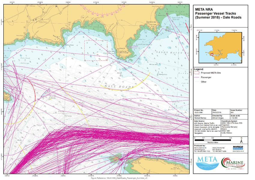
Report No: 18UK1496 -META                          Commercial-in-Confidence                                                                     Report No: 18UK1496 -META                          Commercial-in-Confidence
Issue No: 03                                            META NRA                                                                                Issue No: 03                                            META NRA

Figure 26: Recreational Vessel Transits: East Pickard Bay (winter). ..................................................... 41                                                                                   TABLES
Figure 27: High Speed Craft Transits: Warrior Way (summer). ............................................................ 42                     Table 2-1: Guidance Documents. ............................................................................................................ 5
Figure 28: High Speed Craft Transits: Warrior Way (winter). ............................................................... 43                  Table 2-2: MGN 543 Compliance. ........................................................................................................... 6
Figure 29: High Speed Craft Transits: Dale Roads (summer). ............................................................... 44                   Table 4-1: List of stakeholders consulted (workshop attendees). .......................................................... 9
Figure 30: High Speed Craft Transits: Dale Roads (winter). .................................................................. 44                Table 4-2: List of stakeholders consulted (workshop apologies).......................................................... 10
Figure 31: High Speed Craft Transits: East Pickard Bay (summer). ....................................................... 45                     Table 4-3: Consulation Summary. ......................................................................................................... 11
Figure 32: High Speed Craft Transits: East Pickard Bay (winter)........................................................... 45                   Table 6-1: Summary of vessel arrivals at Milford Haven. ..................................................................... 26
Figure 33: Tug and Service Vessel Transits: Warrior Way (summer). ................................................... 46                        Table 8-1: Warrior Way Deployment and Retrieval. ............................................................................ 56
Figure 34: Tug and Service Vessel Transits: Warrior Way (winter)....................................................... 47                      Table 8-2: Warrior Way Operations and Maintenance. ....................................................................... 56
Figure 35: Tug and Service Vessel Transits: Dale Roads (summer)....................................................... 48                       Table 8-3: Dale Roads Deployment and Retrieval. ............................................................................... 57
Figure 36: Tug and Service Vessel Transits: Dale Roads (winter). ........................................................ 48                    Table 8-4: Dale Roads Operations and Maintenance. .......................................................................... 57
Figure 37: Tug and Service Vessel Transits: East Pickard Bay (summer). ............................................. 49                         Table 8-5: East Pickard Bay Deployment and Retrieval. ....................................................................... 57
Figure 38: Tug and Service Vessel Transits: East Pickard Bay (winter). ................................................ 49                      Table 8-6: East Pickard Bay Operations and Maintenance. .................................................................. 57
Figure 39: MAIB Incidents between 1997-2017. .................................................................................. 50              Table 10-1: Designed-in measures adopted as part of the META project............................................ 67
Figure 40: Primary Incident Cause. ....................................................................................................... 51   Table 10-2: Possible Additional Risk Controls. ...................................................................................... 73
Figure 41: Incident Severity (Since June 2012). .................................................................................... 52
Figure 42: Incident and Near Miss Reports 2013-2018. ....................................................................... 53
Figure 43: Incident Reports by Season.................................................................................................. 54                                                                  ANNEXES
Figure 44: Incidents and Near Misses Reported 2018 (selected categories)........................................ 55                             Annex A          NRA Methodology ...........................................................................................................A-1
Figure 45: Marico Marine Risk Assessment Methodology. .................................................................. 63                     Annex B          Navigation Risk Assessments – Hazard Logs ................................................................... B-1
Figure 46: MHPA Top 10 Navigational Risks. ........................................................................................ 64
Figure 47: Hazards Categorised by Residual Risk. ................................................................................. 65

RPS Energy Consultants Limited                                                                                                            vi    RPS Energy Consultants Limited                                                                                                             vii
Report No: 18UK1496 -META           Commercial-in-Confidence                                          Report No: 18UK1496 -META         Commercial-in-Confidence
Issue No: 03                             META NRA                                                     Issue No: 03                           META NRA

                                     ABBREVIATIONS                                                      Abbreviation        Detail
  Abbreviation        Detail                                                                            MW                  Megawatt
  AIS                 Automatic Identification System                                                   nm                  Nautical Mile
  ALARP               As Low as Reasonably Practicable                                                  NRA                 Navigation Risk Assessment
  ATBA                Area to be Avoided                                                                NTM                 Notice To Mariners
  AtoN                Aid to Navigation                                                                 O&M                 Operations and Maintenance
  CGOC                Coastguard Operations Centre                                                      OREI                Offshore Renewable Energy Installation
  DECC                (Former) Department of Energy and Climate Change                                  PIANC               Permanent International Association of Navigation Congresses
  ERCoP               Emergency Response and Cooperation Plan                                           PMSC                Port Marine Safety Code
  GT                  Gross Tonnage                                                                     RNLI                Royal National Lifeboat Institution
  HAT                 Highest Astronomical Tide                                                         RORO                Roll-On Roll-Off (Vehicle Carriers)
  HMCG                Her Majesty’s Coast Guard                                                         RPS                 RPS Energy Consultants Limited
  HSE                 Health and Safety Executive                                                       RYA                 Royal Yachting Association
  HW                  High Water                                                                        SAR                 Search and Rescue
  IALA                International Association of Lighthouse Authorities                               SHA                 Statutory Harbour Authority
  IMO                 International Maritime Organisation                                               SMS                 Safety Management System
  km                  Kilometre                                                                         STCW                Standards of Training Certification and Watchkeeping
  kt                  Knot (unit of speed equal to nautical mile per hour, approximately 1.15 mph)      TEC                 Tidal Energy Converter
  LAT                 Lowest Astronomical Tide                                                          THLS                Trinity House Lighthouse Service
  LNG                 Liquefied Natural Gas                                                             UKC                 Under Keel Clearance
  LOA                 Length Over-All                                                                   UKHO                UK Hydrographic Office
  LW                  Low Water                                                                         VHF                 Very High Frequency (radio communication)
  m                   Metre                                                                             VLCC                Very Large Crude Carrier
  MAIB                Marine Accident Investigation Branch                                              VMS                 Vessel Monitoring System
  Marico Marine       Marine and Risk Consultants Ltd                                                   VTS                 Vessel Traffic Service
  MCA                 Maritime and Coastguard Agency                                                    WC                  Worst Credible
  META                Marine Energy Test Area Project                                                   WEC                 Wave Energy Converters
  MGN                 Marine Guidance Note                                                              WGS                 World Geodetic System
  MHPA                Milford Haven Port Authority
  MHWN                Mean High Water Neaps
  MHWS                Mean High Water Springs
  ML                  Most Likely
  MLWN                Mean Low Water Neaps
  MLWS                Mean Low Water Springs

RPS Energy Consultants Limited                                                                 viii   RPS Energy Consultants Limited                                                       ix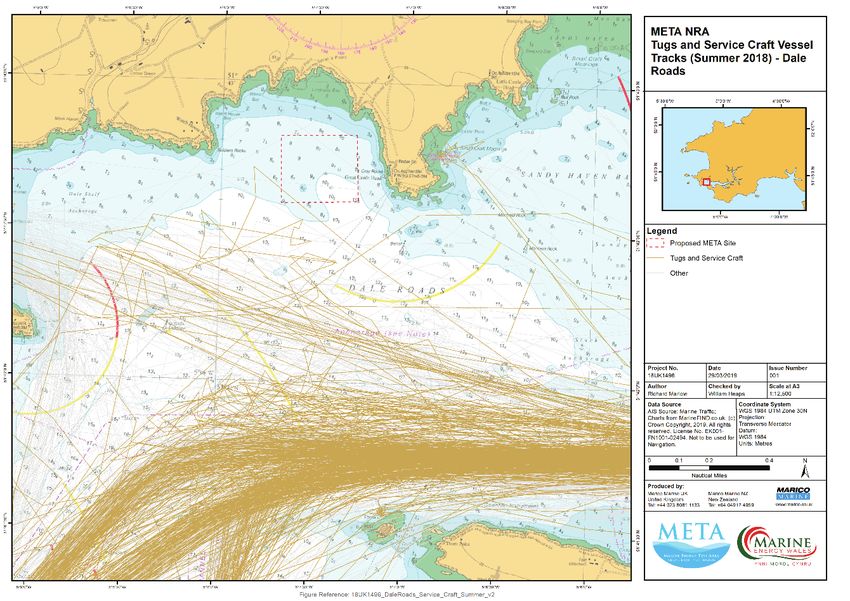
Report No: 18UK1496 -META             Commercial-in-Confidence                                              Report No: 18UK1496 -META            Commercial-in-Confidence
Issue No: 03                               META NRA                                                         Issue No: 03                              META NRA

                                                                                                            2       STUDY AREA
1          INTRODUCTION
                                                                                                            Figure 1 shows the Study Area under assessment. The Study Area includes all Shipping and Navigation

RPS Energy Consultants Limited (RPS) has commissioned Marine and Risk Consultants Ltd (Marico               receptors within an area which has the potential to be affected by the META project. The Study Area

Marine) to undertake a Navigation Risk Assessment (NRA) for the Marine Energy Test Area (META)              encompasses the three META project areas and extends to include the context of the wider Waterway

Project.                                                                                                    and immediate approaches.

Specifically, 3 test sites for the testing of wave and tidal energy devices are proposed within and close   The META project areas comprise three discrete sites:

to the Milford Haven Waterway (hereafter referred to as ‘the Waterway’). This project is closely linked                 x   Warrior Way (site 6), upstream of the Cleddau Toll Bridge;
to a separate project to redevelop part of Pembroke Dock (Pembroke Dock Marine) which will provide                      x   Dale Roads (site 7), at the north-western end of the Waterway; and
a base port for the testing activities and, therefore, a joint NRA process has been undertaken for both                 x   East Pickard Bay (site 8), outside the Waterway and SHA area and south of the eastern
projects. The META and Pembroke projects are reported separately but based on the common NRA                                entrance headland.
process.                                                                                                    Each area is considered separately due to their geographical separation and differing characteristics.

The joint assessment was guided by the Maritime and Coastguard Agency’s (MCA’s) MGN 543
standard for assessing Offshore Renewable Energy Installations (OREIs) as this provides best practice
advice. However, as two of the META sites and the port redevelopment are situated within the
Statutory Harbour Authority (SHA) area of Milford Haven Port Authority (MHPA), some of the advice
in the MGN is not applicable. The MCA has advised that the MGN does not apply within SHA areas,
but it has been agreed that following the guidance where possible demonstrates best practice.

This report describes the META test sites and includes the formal NRA applicable to that project.

RPS Energy Consultants Limited                                                                         1    RPS Energy Consultants Limited                                                                       2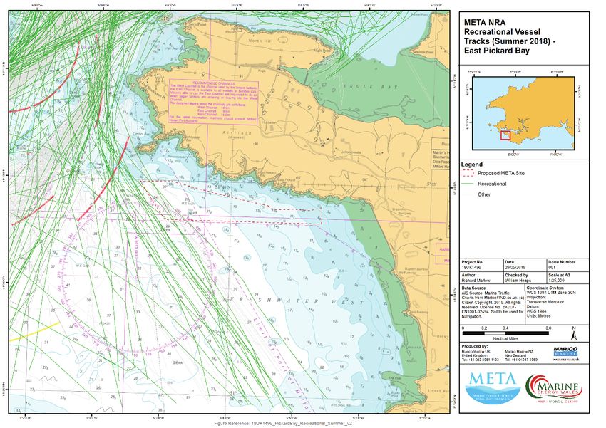
Report No: 18UK1496 -META                  Commercial-in-Confidence
                                                                                                  Issue No: 03                                    META NRA

                                                                 3
                                                                                                  2.1       SCOPE AND METHODOLOGY

                                                                                                  The scope of this assessment is to:

                                                                                                        1) Describe the project sites;
                                                                                                        2) Provide a description of the existing environment and activities in the study areas, including:
                                                                                                                a. Local ports and harbours;
                                                                                                                b. Met-Ocean conditions;
                                                                                                                c. Existing vessel management plans;
                                                                                                                d. Other uses of the area such as aquaculture, anchorages, military and renewable
                                                                                                                     energy installations;
                                                                                                                e. Existing vessel traffic patterns, including frequency and types; and
                                                                                                                f.   Existing risk profile for navigational incidents.
                                                                                                        3) Determine likely future traffic profile;

                            Figure 1: META Test Site Overview.
                                                                                                        4) Identify and assess impacts associated with the development to shipping and navigation,
Commercial-in-Confidence

                                                                                                            including:
     META NRA

                                                                                                                a. Traffic routeing;
                                                                                                                b. Collision risk;
                                                                                                                c. Contact risk;
                                                                                                                d. Communications, radar and positioning systems;
                                                                                                                e. Search and rescue; and
                                                                                                                f.   Cumulative and in-combination effects;
                                                                                                        5) Undertake an NRA that identifies navigational hazards during the installation and operation
                                                                                                            of the META sites. These hazards are assessed, and risk controls identified to reduce the risk
                                                                                                            to As Low as Reasonably Practicable (ALARP); and
                                                                                                        6) Make recommendations as to the navigation safety of the project sites and identify any
                                                                                                            additional measures that should be implemented to further improve safety at the sites.
                                                                 RPS Energy Consultants Limited

                                                                                                  2.2       GUIDANCE
Report No: 18UK1496 -META

                                                                                                  As stated in the introduction, this NRA draws on guidance given in the MCA’s MGN 543 (M+F) which
                                                                                                  sets out the methodology for evaluating navigational safety around OREIs through traffic surveys.
                                                                                                  Further guidance is given in other publications as described in Table 2-1, and relevant parts of each
Issue No: 03

                                                                                                  guidance document has been followed while undertaking this NRA, as appropriate.

                                                                                                  RPS Energy Consultants Limited                                                                         4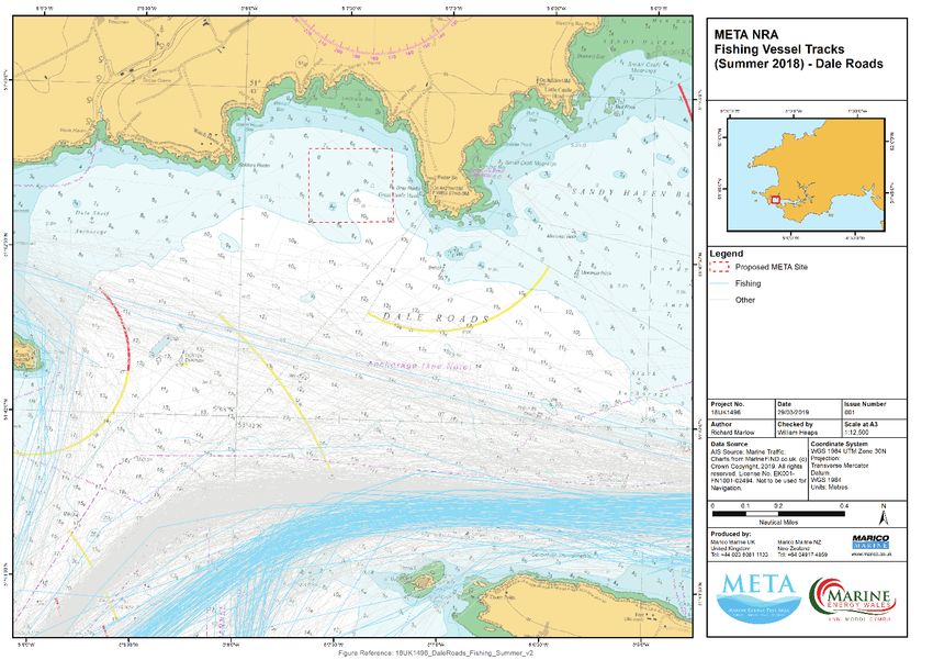
Report No: 18UK1496 -META Commercial-in-Confidence Report No: 18UK1496 -META Commercial-in-Confidence
Issue No: 03 META NRA Issue No: 03 META NRA
The NRA has been undertaken using the IMO approved Formal Safety Assessment Methodology 2.3 MGN 543 COMPLIANCE TABLE
(Described in Annex A).
Table 2-2 acts as an aid for OREI developers when completing and submitting an NRA to the MCA to
Table 2-1: Guidance Documents.
ensure all guidance has been considered and addressed. While it is not required that this assessment
Guidance Key provisions
is undertaken in full compliance with the MGN, the table shows that all aspects of the MGN have been
This MGN highlights issues to be considered when assessing the addressed within this assessment.
MGN 543 Guidance on UK impact on navigational safety and emergency response, caused by
Table 2-2: MGN 543 Compliance.
Navigational Practice, Safety and OREI developments. Including traffic surveys, stakeholder
Annex 1 Report Section
Emergency Response Issues consultation, structure layout, collision avoidance, impacts on
1 An up to date traffic survey of the area Section 4 – Consultation
communications/ radar/ positioning systems and hydrography.
Section 6 – Existing Vessel Traffic at the Test
MGN 372 Guidance to Mariners Issues to be considered when planning and undertaking voyages Sites
Operating in the Vicinity of UK OREIs near OREI developments off the UK coast. Section 9 – Potential Impacts to Navigation
2 OREI structures Section 9 – Potential Impacts to Navigation
International Association of Marine
3 Assessment of access to and navigation within, Section 9 – Potential Impacts to Navigation
Aids to Navigation and Lighthouse or close to, an OREI
Guidance to national authorities on the marking of offshore Section 10.3 – Risk Control Options
Authorities (IALA AISM) 0-139 the
structures. Annex 2 Report Section
Marking of Man-Made Offshore
Structures. 1 Effects of tides and tidal streams Section 5.1 – MetOcean Conditions
Section 9.3 – The Effects of Tides, Tidal Streams
International Maritime Organisation and Weather
(IMO) (2018) Formal Safety Process for undertaking marine navigation risk assessments. 2 Weather Section 5.1 – MetOcean Conditions
Assessment. Section 9.3 – The Effects of Tides, Tidal Streams
and Weather
Royal Yachting Association (RYA)
Outlines recreational boating concerns for offshore renewable 3 Visual navigation and collision avoidance Section 9 – Potential Impacts to Navigation
Position on Offshore Energy
energy developments. Section 9.8 – Impact on Search and Rescue and
Developments Emergency Response
HSE and MCA (2017) Regulatory 4 Communications, radar and positioning Section 9.9 - Impact on Communications, Radar
systems and Positioning Systems
expectations on moorings for floating Guidance document on mooring arrangements for OREIs.
5 Marine navigational marking Section 10.3.1.1 - Measures adopted as part of
wind and marine devices
the META Project
MCA (2013) Methodology for Annex 3 Report Section
Assessing the Marine Navigational 1 MCA Shipping Route Template Section 9.1 – Impact on Vessel Traffic Routeing
Methodology for Assessing the Marine Navigational Safety &
Safety & Emergency Response Risks Annex 4 Report Section
Emergency Response Risks of OREI.
of Offshore Renewable Energy 1 Safety and mitigation measures Section 10.3 – Risk Control Options
Installations (OREI) Section 10.5 – Possible Additional Risk Controls
Annex 5 Report Section
1 Emergency response Section 9.8 – Impact on Search and Rescue and
Emergency Response
RPS Energy Consultants Limited 5 RPS Energy Consultants Limited 6Report No: 18UK1496 -META Commercial-in-Confidence Report No: 18UK1496 -META Commercial-in-Confidence
Issue No: 03 META NRA Issue No: 03 META NRA
3 MARINE ENERGY TEST AREA (META) PROJECT x Site preparation methodologies;
x Decommissioning methodologies; and
3.1 OVERVIEW x Salvage methodologies.
Marine Energy Wales’s (MEW) proposed Marine Energy Testing Area (the META Project) forms part 3.2.2 Dale Roads (Site 7)
of Pembroke Dock Marine, a £76 million project to develop a world class centre for marine energy
Dale Roads lies outside the Dale shelf anchorage within the Waterway to the west of Great Castle
development, fabrication, testing and deployment, in Pembrokeshire. The four pillars of the
Head, and south of St Ishmael’s. It supports depths of between 8 and 12 m and benefits from a
Pembrokeshire Dock Marine Project include:
significant wind and wave fetch from the south and southwest. The site encompasses an area of
x The META Project (being developed by MEW); 0.195 km2.
x Marine Energy Engineering Centre of Excellence (MEECE) (an Offshore Renewable Dale Roads will enable testing of:
Energy Catapult project);
x Pembroke Port managed and operated by Milford Haven Port Authority; and x Scaled wave energy converter (WEC) devices;
x Pembrokeshire Demonstration Zone (PDZ) (being developed by WaveHub). x Full-scale WEC devices; and
The META Project will support developer testing of marine energy component, sub-assembly, x Research and monitoring methodologies.
instrumentation and marine renewable devices including trialling installation, retrieval and 3.2.3 East Pickard Bay (Site 8)
decommissioning methodologies and operation and maintenance activities. These will be undertaken
The north-west side of East Pickard Bay overlaps with the southern boundary of the Waterway. It lies
in a wide range of environmental conditions, thereby de-risking marine energy technology
immediately south of Sheep Island and runs south-eastward parallel to the coast towards Freshwater
deployment. The META Project sites include sheltered marine environments as well as larger full-scale
West Bay.
marine testing areas.
The East Pickard Bay site is exposed to a good wave resource benefiting from a 200 km fetch from the
3.2 MARINE COMPONENTS OF THE PROJECT prevailing wind direction and has a water depth of between 10 and 29 m. The East Pickard Bay site
encompasses an area of 1.233 km2.
The activities that will be supported at these sites are summarised below for each site. Full details
are provided within Chapter 2: Project Description, of the META Environmental Statement (ES). The site also lies adjacent to a Ministry of Defence (MOD) Danger Area (Castlemartin Military Practice
Area D113A).
3.2.1 Warrior Way (Site 6)
East Pickard Bay will enable testing of:
Warrior Way is located within the Waterway adjacent to the Pembrokeshire Science and Technology
x Full-scale WEC device testing;
Park, south east of Pembroke Ferry, and at the mouth of the Cosheston Pill. The site supports the
x Scaled WEC device testing; and
greatest tidal resource in the Waterway (1.2 m/s) and has a depth of between 16-19 m. The Warrior
x Component testing for floating offshore wind technology.
Way site encompasses an area of 0.093 km2.
Warrior Way will enable testing of:
x Scaled tidal devices,
x Micro tidal devices,
x Instruments, components and sub-assemblies;
x ROV or other monitoring equipment;
RPS Energy Consultants Limited 7 RPS Energy Consultants Limited 8Report No: 18UK1496 -META Commercial-in-Confidence Report No: 18UK1496 -META Commercial-in-Confidence
Issue No: 03 META NRA Issue No: 03 META NRA
4 CONSULTATION Table 4-2: List of stakeholders consulted (workshop apologies).
Company
4.1 CONSULTEES MHPA
Pembroke Haven Yacht Club
Consultation was carried out with key stakeholders to gain local knowledge and insight on navigation.
Irish Ferries (supplied email comment)
This was predominantly achieved through a half-day stakeholder meeting held at Pembroke Dock on
MCA (phone consultation)
Wednesday 30 January 2019.
THLS (phone consultation)
In addition, telephone consultation was undertaken with the MCA and Trinity House Lighthouse RNLI
Services (THLS).
The following organisations did not respond to the consultation invitation:
Further detailed consultation was undertaken during a visit to the offices of MHPA on the afternoon x Milford Haven Fisheries Group
of 30 January 2019, with the chief aim of obtaining additional data and traffic information. x South Wales Sea Fisheries Committee
Table 4-1 and Table 4-2 set out the list of stakeholders consulted including the list of workshop x Welsh Federation of Sea Anglers
attendees. Where stakeholders were unable to attend the workshop, telephone and/or email x Pembrokeshire Cruiser Racing Club
consultation was undertaken where possible, as indicated within Table 4-2. x Lawrenny Yacht Club
x Neyland Yacht Club
A summary of all consultation is given in Table 4-1.
x PYC – Gelliswick
Table 4-1: List of stakeholders consulted (workshop attendees).
Company x Williams Shipping
Marine Energy Wales x Svitzer
RPS x SMIT – Range Safety Boat
Marico x South Hook LNG
Port of Milford Haven x Dragon LNG
Dale Yacht Club
Valero
Pembroke Yacht Haven
Puma Energy
Milford Harbour Users Association (MHUA)
Warrior Cove Pembrokeshire Activity Centre & Pembrokeshire Performance Sailing Academy
RPS Energy Consultants Limited 9 RPS Energy Consultants Limited 10Report No: 18UK1496 -META Commercial-in-Confidence Report No: 18UK1496 -META Commercial-in-Confidence
Issue No: 03 META NRA Issue No: 03 META NRA
4.2 CONSULTATION SUMMARY Date Consultee and Issues raised
type of response
Table 4-3: Consulation Summary. Particular attention should be paid to cabling routes and
where appropriate burial depth. If cable protection is
Date Consultee and Issues raised
required, the MCA would be willing to accept a 5%
type of response
reduction in surrounding depths referenced to Chart
5 November RNLI, meeting and Floating infrastructure may attract kayakers/surfers etc to Datum.
2018 subsequent email the area of deployments at East Pickard Bay thereby The cumulative and in combination effects require
correspondence increasing the risk of interactions with the devices/buoys. consideration, in particular regarding shipping routes.
17 January Email from MCA Impact of proposed devices on the safety of navigation. In 22 January Telecon with MCA MCA confirmed that radar data / visual data not required
2019 summarising particular, allision/contact, changes to vessel routing and 2019 to inform the NRA, providing that robust alternatives are
Scoping Response to reduction in navigable space (and any resulting increase in demonstrated in the form of wide consultation.
NRW/MMO the frequency of encounters), any constraints placed on
recreational, commercial and fishing vessels operating in or 24 January Email from Irish Effects on ferry schedule and services with the twice daily
transiting the area and access ports and harbours. 2019 Ferries sailings from Pembroke Dock Ferry Terminal.
The Environmental Statement should provide details on the Main issues:
following possible impacts on navigational issues for both Restricted access to Pembroke Dock Ferry Terminal.
commercial and recreational craft: The narrow Navigable Channel which the Ferry transits, and
Collision Risk no other vessel movements permitted during her transit to
Navigational Safety the berth.
Visual intrusion and noise Increased activity around Pembroke Dock waterway, which
Risk Management and Emergency response could incur slow passing of berths, causing delays.
Marking and lighting of site and information to mariners Delays to ferry service due weather and the impact any
activity would have with this project.
Effect on small craft navigational and communication
equipment 24 January Email from THLS Any existing aids to navigation in the META project areas
The risk to drifting recreational craft in adverse weather or 2019 should be maintained or fully risk assessed with the
tidal conditions Harbour Authority before removal or relocation. This would
then need to be consented by THLS.
The likely squeeze of small craft into the routes of larger
commercial vessels. If any additional aids to navigation are considered, THLS will
need to be consulted and can provide specific advice. THLS
A NRA will need to be submitted in accordance with MGN
would stipulate any aids to navigation in their advice to
543 (and MGN 372).
NRW during the licencing process.
The shipping and navigation study should include radar and
META project areas will need some form of marking due to
manual observations in addition to AIS data to ensure
the recreational and other small vessels operating in the
vessels of less than 300gt are captured and should be
area. This would most probably be through a mix of lit/unlit
completed within 24 months prior to the Environmental
cardinal and special marks. THLS will provide a firm
Statement submission. Casualty information from the MAIB
direction following consultation with the Harbour Authority
and RNLI would also be good data sources.
during the licencing process.
The mooring arrangements for any floating turbines should
be carried out in accordance with the MCA and HSE 30 January Stakeholder Warrior Way
Guidance ‘Regulatory expectations on moorings for floating 2019 (Navigation) There is an activity centre at Warrior Way [the
wind and marine devices’, which also include Third Party Workshop Pembrokeshire Performance Sailing Academy, offering
Verification. dinghy sailing, power boat and shore-based courses],
The marking of offshore wave and tidal energy installations meaning there will be a lot of small vessel activity.
will be based on recommendations of the IALA. Yacht racing occurs at Neyland and Pembroke Yacht Club at
Consideration will need to be given to the implications of Hobbs Point – Wednesday nights and Sunday. Start line
the site size and location on SAR resources and Emergency uses entire width of the Waterway at Hobbs Point [these
Response Co-operation Plans (ERCOP).
RPS Energy Consultants Limited 11 RPS Energy Consultants Limited 12Report No: 18UK1496 -META Commercial-in-Confidence Report No: 18UK1496 -META Commercial-in-Confidence
Issue No: 03 META NRA Issue No: 03 META NRA
Date Consultee and Issues raised Date Consultee and Issues raised
type of response type of response
races go downstream from the start line which is in line Most traffic would likely be lobster fisherman, or the Navy
with Neyland marina entrance]. transiting through the site to their training areas.
Cruiser racing predominately occurs in daylight hours, 12- Kayaking is sporadic, however there is potential for surfers
20 boats maximum, of 29-35 foot to investigate the devices.
Kids jumping/swimming across from Hobbs Point Jetty 30 January Stakeholder Other general points raised:
[unofficially] 2019 (Navigation) The MHPA regularly patrol the waters May-September.
Concern that activities at Warrior Way may cause vessels to Workshop
be pushed towards the shallows on the opposite side of the Potential for reduced under keel clearance.
Waterway. It was noted that there is good management and
Small craft training occurs at Warrior Way, and several relationships between recreational users and the port
children may use the slipway at any one time during the authority, with a designated officer. Activities are generally
Spring/Summer. A dedicated safety boat recovers people away from the Port and there is well-established
(including children) from the water following practice interaction.
capsize events. Concern that unattended small craft could 22 February Email from Key points in relation to Warrior Way:
drift into the Warrior Way area with the tidal flow. 2019 Pembrokeshire AIS and RYA data sources are unreliable for the area.
Some potting occurs within the Warrior Way area. Line Performance Sailing
Many members of the public use the slipway seasonally at
fishing also occurs (predominately recreational). Academy
Warrior Way/Cleddau Reach to launch/recover craft
Potential conflicts are not insurmountable with careful (sailing dinghies, powerboats/sportboats, water
planning and management. ski/wakeboard users and Personal Watercraft). In addition,
30 January Stakeholder Dale Roads PPSA, Llanion Cove and other paddlesports and multi-
2019 (Navigation) activity users use the slipway throughout the year.
Water sports occur at a lower level compared with Warrior
Workshop Way. Diving occurs on the wrecks to the south of Great The site boundaries encompass the slipway area and would
Castle Head. Occasional power boat training. Swimming is compress access to the river east of the Cleddau
generally discouraged in the Waterway, and restricted to Bridge. Request that if possible the boundaries be revised.
sheltered bays (e.g. Dale Bay, Sandy Haven) Request consultation regarding scheduling of activities
Some potting for whelks occurs in the vicinity, and there are before a Notice to Mariners is published, due to the need
lots of unmarked fishing buoys. 5/6 fisherman were to accommodate advance bookings.
understood to use the Dale area commercially, with the The area is used to train novice sailors and powerboat
rocky reef habitats favoured (noting that these rocky reef users. There may be times when boats drift into the META
areas have been excluded from the META sites), and a few test area. The proposed site is also within the area used for
take out recreational fisherman. 3-4 line fisherman operate introducing planned speed manoeuvres on powerboat
from Dale Roads. courses.
Potential risk from breakout of META devices and
associated drifting/sinking. Also potential risk of third party
vessel breakout impacting a META device in this area.
Small tankers anchor to the western end of the Dale Bay.
There are similar, but more dispersed, vessel traffic levels
to Warrior Way.
30 January Stakeholder East Pickard Bay
2019 (Navigation) Commercial vessels and cruise ships are unlikely to use the
Workshop site.
Potting occurs along the coast, but the site is at the edge of
the 10 m contour.
RPS Energy Consultants Limited 13 RPS Energy Consultants Limited 14Report No: 18UK1496 -META Commercial-in-Confidence Report No: 18UK1496 -META Commercial-in-Confidence
Issue No: 03 META NRA Issue No: 03 META NRA
5 OVERVIEW OF THE MARINE ENVIRONMENT As noted above the Waterway is very sheltered, especially from the prevailing south westerly winds.
However, Dale Roads is exposed to swells and wind from the south, and East Pickard Bay, lying outside
The test sites are situated within, or close to the entrance to, the Milford Haven Waterway. The Port the headlands is very exposed to the prevailing south westerly weather conditions.
of Milford Haven is a leading UK shipping gateway handling liquid bulk, break bulk, dry bulk and project
cargoes. It is known as the UK's largest energy port and is capable of delivering 30% of the UK gas 5.2 EXISTING VESSEL TRAFFIC MANAGEMENT
demand.
The Waterway is managed by the Port of Milford Haven, a Trust Port, which is responsible for pilotage
The Port currently serves: Valero Refinery and Valero Pembrokeshire Oil Terminal, Puma Energy,
and conservancy on the Waterway. Warrior Way and Dale Roads are within the Milford Haven
South Hook LNG and Dragon LNG. Cargoes are received from the North Sea, North and West Africa,
Statutory Harbour Authority (SHA) and Competent Harbour Authority (CHA) areas managed by MHPA.
the Middle East, Asia and Europe and processed materials are transported domestically and
Marine risks have been assessed and reviewed on an ongoing basis through procedures included in
internationally. The Waterway is also home to Europe’s largest gas-fired power station, Pembroke
MHPA’s Marine Management System. MHPA provides a VTS service actively monitoring the whole
Power Station. Additionally, Milford Haven Docks are home to a fishing fleet, and Pembroke Dock
Waterway below the Cleddau Bridge.
facilitates a twice daily ferry service to Ireland, as well as general and project cargo facilities. Pembroke
East Pickard Bay is largely out-with of the SHA area, and therefore, the port authority has no statutory
Dock is redeveloping to accommodate marine renewable energy support craft.
duty or powers to direct traffic within the majority of this proposed test area, which is in UK waters
The Waterway also includes a number of smaller harbours and marinas and is popular with leisure
and thus the MCA is the responsible authority for safe navigation. However, the site is very close to
mariners.
the approaches to Milford Haven, and all commercial traffic passing close by, or through the proposed
site, is likely to be bound to or from the port, and therefore subject to pilotage, and other existing port
5.1 METOCEAN CONDITIONS
control measures such as passage planning requirements.
The natural estuary of Milford Haven provides deep water berths and most vessels have 24-hour tidal
access.
A weather station exists at Milford Haven (51 42’N 005 03’W, height 32m Above MSL) where data has
been continuously collected and analysed since at least 1980. The weather data is summarised in the
UKHO Publication NP37 – Admiralty Sailing Directions – West Coasts of England and Wales Pilot, and
therefore, available to mariners using the port.
In summary Milford Haven experiences prevailing south westerly winds, though winds from the north
west and south east are not uncommon, with south easterly winds being more common in the
mornings from March to June inclusive. NP137 (Section 1.140) gives more detail.
During the period 1980 to 2010, gale force winds were experienced on average 33 days per year,
mainly in the period October to March inclusive, and predominantly from a west, to south westerly
direction.
The same 30-year period saw fog recorded on 27 days per year, on average (more frequently in the
March to July period).
Figure 2: Statutory Harbour Authority Area.
RPS Energy Consultants Limited 15 RPS Energy Consultants Limited 16Report No: 18UK1496 -META Commercial-in-Confidence Report No: 18UK1496 -META Commercial-in-Confidence
Issue No: 03 META NRA Issue No: 03 META NRA
5.3 SEARCH AND RESCUE 5.4.3 Anchorages
No formal anchorages exist in any of the sites. A regularly used anchorage named Dale Roads is
Royal National Lifeboat Institution (RNLI) lifeboats are stationed at Angle on the southern shore of the
managed by MHPA and vessels are directed to a charted area while awaiting orders. The designated
Waterway, south west of the town of Milford Haven. The Angle lifeboat is a Tamar class all weather
anchorage is some 0.5 NM south of the proposed Dale Roads META project test site.
lifeboat. The lifeboat is 16.3m LOA, has a crew of seven, and is capable of 25 knots having a range of
250 nm. In addition, two “D” class inshore lifeboats are based at the station. There are no restrictions on anchoring in any of the sites, and none are likely to be used by commercial
vessels, but leisure vessels may choose to anchor in the shallower waters of Warrior Way and Dale
Her Majesty’s Coastguard (HMCG) helicopter assets are based at St Athan near Cardiff and Newquay
Roads. It is not considered likely that any vessel would choose to anchor in East Pickard Bay, except in
in Cornwall.
emergency.
Milford Haven Coastguard Operations Centre (CGOC) is the local coastguard base for the region and
co-located with the MHPA offices and VTS centre. The 2015 implementation of the Future Coastguard 5.4.4 Military Exercise Areas
Programme saw a restructuring of the CGOCs and implementation of a new IT system that enabled
There are no military exercise areas within the Waterway (no impact on Warrior Way or Dale Roads).
areas to be monitored and incidents responded to from any CGOC or from the National Maritime
A large and active range exists outside the entrance to the Waterway (Castlemartin Firing Range),
Operations Centre (NMOC), near Southampton. Therefore, whilst Milford Haven CGOC would likely
immediately adjacent to the East Pickard Bay site. While the range is active, it is actively managed
manage an incident in the Waterway, it could be managed from elsewhere.
and protected by a range safety vessel.
5.4 OTHER MARINE ACTIVITIES 5.4.5 Dredging Areas and Spoil Grounds
The following marine activities have been identified as currently existing in the study area or may be MHPA carries out maintenance dredging in several areas of the Waterway, chiefly in the main deep-
relevant in the future. water channel and approaches to the main hydrocarbon jetties. There is a licensed maintenance
dredge area covering the principal berths in Pembroke Dock and their approaches (DML 1666, licence
5.4.1 Marine renewable energy installations
expires 08 March 2022) 1.
There are no existing marine renewable energy installations within the META test areas or wider
Two licensed disposal sites exist in the Milford Haven area – the principal site being outside the
Waterway however marine renewable energy development is being encouraged through the
entrance to seaward (Milford Haven / St Anns Head), while a small area also exists closer to Pembroke
Pembroke Dock Marine project.
Dock towards the Cleddau Bridge (LU 190 “Neyland [off Milford Haven]).
5.4.2 Subsea Cables Dredging is managed by MHPA, while licensing of dredge areas and disposal sites are regulated by
NRW through licensing / consents.
Numerous subsea cables are charted in the Waterway. There are currently none charted in, or close
to, the proposed East Pickard Bay or Dales Road sites. One cable is charted (UKHO Chart 3275) close None of these activities are likely to directly impact on operations in any of the three sites under
to the western boundary of Warrior Way crossing from bank to bank of the Waterway. A pipeline also consideration.
crosses the Waterway between the site boundary and the Cleddau Bridge.
1 Source – NRW data portal
RPS Energy Consultants Limited 17 RPS Energy Consultants Limited 18You can also read