Burnaby Mountain Gondola Transit - Technology and Alignment Alternatives Assessment October 2011
←
→
Page content transcription
If your browser does not render page correctly, please read the page content below
Final Report

Burnaby Mountain Gondola Transit
Technology and Alignment
Alternatives Assessment

October 2011

Prepared for

Prepared by
CONTENTS
Executive Summary ............................................................................................................. iii
Acronyms and Abbreviations .............................................................................................. v
1.    Introduction ............................................................................................................ 1-1
2.    Purpose ................................................................................................................... 2-1
3.    Physical Constraints .............................................................................................. 3-1
      3.1    Road Network ............................................................................................... 3-1
      3.2    Surrounding Land Uses ................................................................................ 3-2
4.    Review of Existing Transit Service ....................................................................... 4-1
      4.1    Existing Bus Routes ..................................................................................... 4-2
             4.1.1 Proportion of Service ....................................................................... 4-2
      4.2    Capacity Requirements ................................................................................ 4-3
      4.3    Travel Time and Transit Service Requirements ........................................... 4-4
      4.4    Multi-Modality ............................................................................................... 4-6
5.    Overview of Transit Solutions............................................................................... 5-1
      5.1    Primary Screening Evaluation Criteria .......................................................... 5-1
      5.2    Base Case – Diesel Bus ............................................................................... 5-2
      5.3    Ground-Based Solutions .............................................................................. 5-3
             5.3.1 BRT – Trolleybus............................................................................. 5-3
             5.3.2 Light Rail Transit (LRT) ................................................................... 5-5
             5.3.3 Guided Light Transit (GLT).............................................................. 5-6
             5.3.4 Funicular.......................................................................................... 5-7
             5.3.5 Rack Railway................................................................................... 5-8
             5.3.6 Rail Rapid Transit (SkyTrain) .......................................................... 5-9
             5.3.7 Personal Rapid Transit (PRT) ....................................................... 5-10
             5.3.8 Escalator ....................................................................................... 5-10
             5.3.9 Ground-based Conclusions ........................................................... 5-11
      5.4    Aerial Transit Solutions............................................................................... 5-12
             5.4.1 Aerial Tram/Reversible Ropeway .................................................. 5-12
             5.4.2 Detachable Gondolas .................................................................... 5-13
             5.4.3 Aerial Transit Conclusions............................................................. 5-17
      5.5    Primary Screen Conclusions ...................................................................... 5-18
6.    Secondary Screening............................................................................................. 6-1
      6.1    Evaluation Summary .................................................................................... 6-2
             6.1.1 Financial .......................................................................................... 6-6
             6.1.2 Transportation ................................................................................. 6-6
             6.1.3 Environmental ................................................................................. 6-6
             6.1.4 Urban and Economic Development ................................................. 6-6
             6.1.5 Social............................................................................................... 6-6
             6.1.6 Deliverability .................................................................................... 6-7
             6.1.7 Overall ............................................................................................. 6-7
      6.2    3S versus Funitel .......................................................................................... 6-7
      6.3    Precedents for Urban Ropeway Transit ....................................................... 6-8
7.    Alternative Alignment Assessment ...................................................................... 7-1
      7.1    Alignment Options ........................................................................................ 7-1

412504_TBG011911024037VBC                                                                                                           i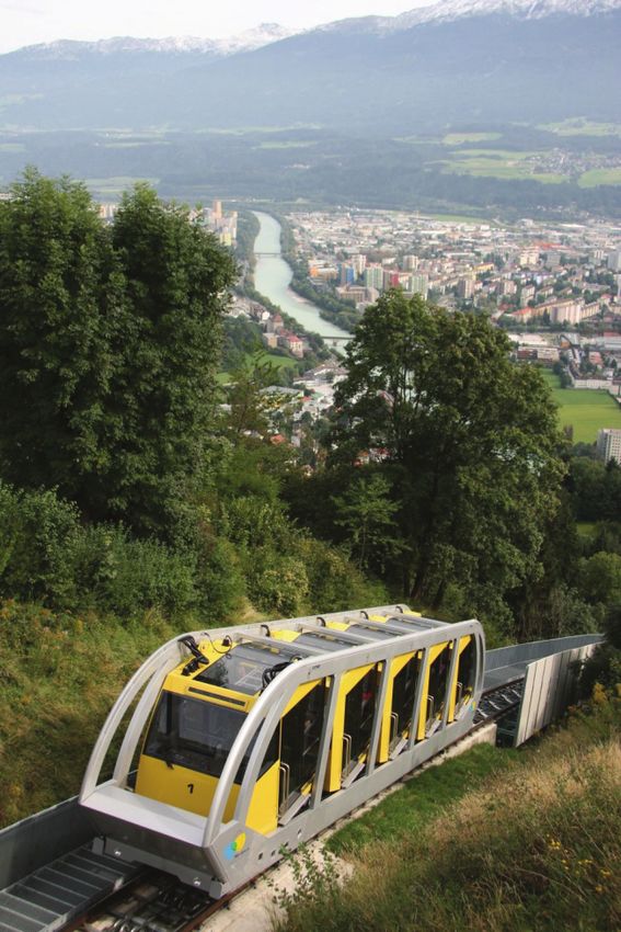
BURNABY MOUNTAIN GONDOLA TRANSIT CONTENTS
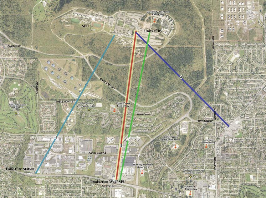
7.2 Alignment Evaluation .................................................................................... 7-2
7.2.1 Route 1: Lake City – South Campus Road ..................................... 7-3
7.2.2 Route 2: Production Way – SFU Bus Exchange ............................. 7-4
7.2.3 Route 3: Production Way – Tower Road ......................................... 7-4
7.2.4 Route 4: Burquitlam – SFU Bus Exchange ..................................... 7-4
7.3 Conclusion .................................................................................................... 7-5
8. Technology and Alignment Conclusion ............................................................... 8-1
Exhibits
Exhibit 3-1 – Road Network within Study Area .................................................................... 3-1
Exhibit 4-1 – Map of Existing Burnaby Mountain Bus Routes .............................................. 4-1
Exhibit 4-2 – Current (2009) Bus Ridership on Burnaby Mountain Routes .......................... 4-3
Exhibit 4-3 – Ridership Forecasts with Evergreen Line ....................................................... 4-5
Exhibit 4-4 – Ridership Forecasts without Evergreen Line .................................................. 4-5
Exhibit 4-5 – Shared Vehicle/Bicycle Roadways and Trails ................................................. 4-6
Exhibit 4-6 – Burnaby Mountain Conservation Area Trail Map ............................................ 4-7
Exhibit 5-1 – Articulated Diesel Bus Serving SFU................................................................ 5-2
Exhibit 5-2 – TransLink Articulated Electric Trolleybus ........................................................ 5-3
Exhibit 5-3 – LRT Train in Paris ........................................................................................... 5-5
Exhibit 5-4 – Funicular (Hungerbergbahn) in Innsbruck, Austria ......................................... 5-7
Exhibit 5-5 – Rack-equipped Metro Line in Lyon, France .................................................... 5-8
Exhibit 5-6 – SkyTrain near Main Street – Science World Station ....................................... 5-9
Exhibit 5-7 – Table of Ground-Based Technologies Assessed .......................................... 5-11
Exhibit 5-8 – Portland (Oregon) Aerial Tram ...................................................................... 5-12
Exhibit 5-9 – Whistler Village Gondola ............................................................................... 5-14
Exhibit 5-10 – Whistler Peak 2 Peak 3S Gondola .............................................................. 5-15
Exhibit 5-11 – Table of Aerial Technologies Assessed ...................................................... 5-17
Exhibit 5-12 – Results of Primary Screening...................................................................... 5-18
Exhibit 6-1 – Burnaby Mountain Gondola Transit – Alternative Technology
Secondary Screening .................................................................................. 6-3
Exhibit 7-1 – BMGT Alignment Alternatives ......................................................................... 7-2
Exhibit 7-2 – Alignment Evaluation Summary ...................................................................... 7-3
412504_TBG011911024037VBC ii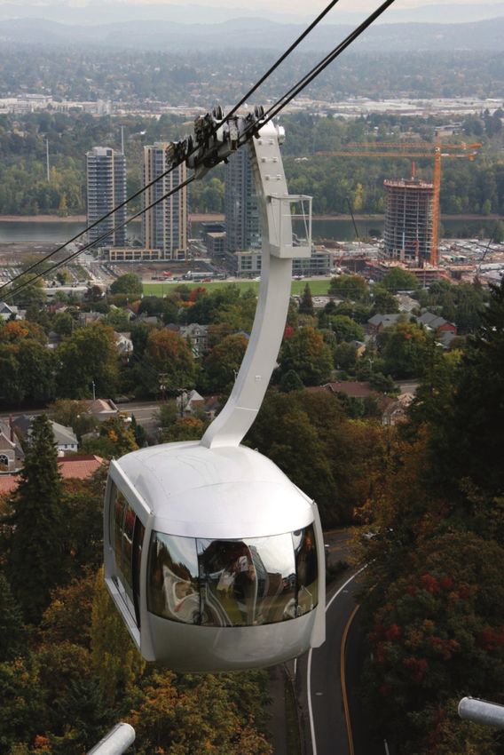
EXECUTIVE SUMMARY
Forecast growth of both the Simon Fraser University (SFU) campus and UniverCity
neighbourhood on Burnaby Mountain will increase transit demand in 2021 and 2041 beyond
the capacities that can be met by frequent bus service. This increasing demand indicates
the need to review alternative technologies to meet the future requirements, particularly
given the unique topographical challenges imposed by the mountain-top location of the
campus and neighbourhood.
Higher level policies need to be taken into account when reviewing potential solutions for
addressing the transit needs of Burnaby Mountain to ensure that any actions are consistent
with overall goals. The Provincial Climate Action Program and Transit Plan have set
aggressive targets in terms of reductions in emissions and gains in transit mode share.
TransLink has adopted these targets and has further formulated strategies to achieve these
– as well as supporting goals – in its Transport 2040 planning process. The consideration of
alternative transit solutions for Burnaby Mountain speaks directly to three of the strategies
outlined in Transport 2040:
Make early investments that encourage development of communities designed for
transit, cycling, and walking (SFU and UniverCity are good examples of such
communities)
Optimize the use of the region’s transportation assets and keep them in good repair (a
potential reallocation of diesel bus service to areas with gentler grades and an overall
reduction in transit operating costs for serving the mountain would support this)
Build and operate a safe, secure, and accessible transportation system (alternative
transit solutions for Burnaby Mountain would be superior to buses in these respects)
The technology alternatives examined include the following:
Ground-based solutions
Bus Rapid Transit (BRT) - Diesel/Trolleybus
Light Rail Transit (LRT)
Guided Light Transit (GLT)
Funicular
Rack Railway
Rail Rapid Transit
Aerial solutions
Aerial Tram/Reversible Ropeway
Gondola (Monocable/2S/3S)
Funitel
412504_TBG011911024037VBC iii
BURNABY MOUNTAIN GONDOLA TRANSIT EXECUTIVE SUMMARY
Alternatives were evaluated against a broad range of criteria and classified under the
primary accounts described in the Purpose and Need Report, namely:
Financial
Transportation
Environmental
Urban Development
Economic Development
Social/Community
Deliverability
Based on screening-level analysis, ground-based transit solutions were excluded from
consideration based on the following:
Technical infeasibility due to standard performance requirements such as maximum
grades and minimum turning radii being exceeded; and,
Significantly higher economic and environmental costs of obtaining right-of-way
compared to other options.
The diesel base case and trolleybus alternative have challenges in meeting capacity in an
efficient manner.
The aerial solutions are compared in greater detail, with the 3S and Funitel systems
identified as the preferred candidates for best achieving the evaluation criteria.
With the technology family identified, prospective alignments were evaluated, including
routes starting at the existing Lake City Way and Production Way – University SkyTrain
stations, as well as at the future Burquitlam Station on the Evergreen Line. A direct route
from Production Way – University SkyTrain Station to the SFU Bus Exchange emerged as
the one that best meets the following objectives:
Minimize conservation area impacts;
Minimize neighbourhood impacts;
Minimize length of route – (reduce cost and travel time, avoiding kinked alignments);
Minimize specific impacts of tower locations; and,
Maximize transit integration – with SkyTrain and SFU/UniverCity.
412504_TBG011911024037VBC iv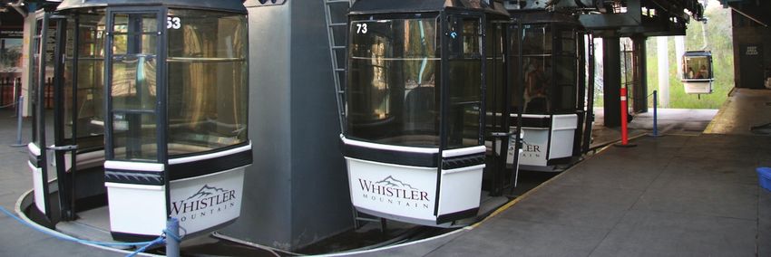
ACRONYMS AND ABBREVIATIONS
BAU                         business as usual
BRT                         Bus Rapid Transit
CAC                         criteria air contaminant
CMBC                        Coast Mountain Bus Company
CNG                         compressed natural gas
FTN                         Frequent Transit Network
GHG                         greenhouse gas
GLT                         Guided Light Transit
ha                          hectare(s)
IFS                         Initial Feasibility Study
km                          kilometre(s)
     2
km                          square kilometre(s)
LID                         Low Impact Development
LIM                         linear induction motor
LRT                         Light Rail Transit
m                           metre(s)
m2                          square metre(s)
O&M                         operations and maintenance
OCP                         Official Community Plan
pphpd                       passengers per hour per direction
PRT                         Personal Rapid Transit
PTP                         Provincial Transit Plan
RGS                         Regional Growth Strategy
ROW                         right-of-way
RRT                         Rail Rapid Transit
RTD                         Regional Transportation District
SCBCTA                      South Coast British Columbia Transportation Act

412504_TBG011911024037VBC                                                     v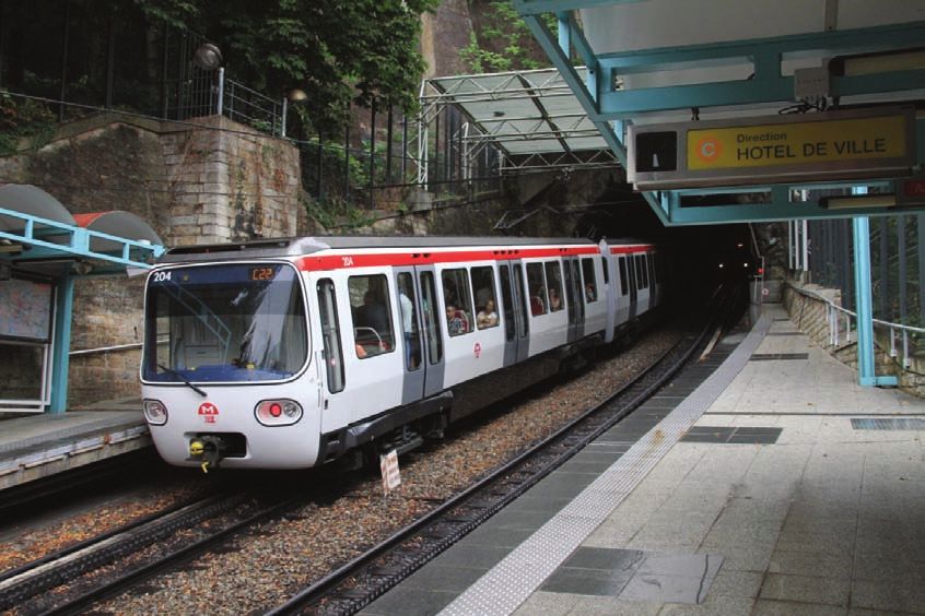
BURNABY MOUNTAIN GONDOLA TRANSIT                                             ACRONYMS AND ABBREVIATIONS

SFU                         Simon Fraser University
TCQSM                       Transit Capacity and Quality of Service Manual
TRB                         Transportation Research Board
TSP                         transit signal priority

412504_TBG011911024037VBC                                                                            vi
1. INTRODUCTION
Forecast growth of both the Simon Fraser University (SFU) campus and UniverCity
neighbourhood on Burnaby Mountain will increase transit demand in 2021 and 2041,
beyond the peak capacities that can be met by frequent bus service. This increasing
demand indicates the need to review alternative technologies to meet the future
requirements, particularly given the unique topographical challenges imposed by the
mountain-top location of the campus and neighbourhood.
Higher level policies need to be taken into account when reviewing potential solutions for
addressing the transit needs of Burnaby Mountain to ensure that any actions are consistent
with overall goals. The Provincial Climate Action Program and Transit Plan have set
aggressive targets in terms of reductions in emissions and gains in transit mode share.
TransLink has adopted these targets and has further formulated strategies to achieve these
– as well as supporting goals – in its Transport 2040 planning process.
The consideration of alternative transit solutions for Burnaby Mountain speaks directly to
three of the strategies outlined in Transport 2040:
Make early investments that encourage development of communities designed for
transit, cycling, and walking (SFU and UniverCity are good examples of this community
type)
Optimize the use of the region’s transportation assets and keep them in good repair
(through potential reallocation of diesel bus service to areas with gentler grades and an
overall reduction in transit operating costs for serving the mountain)
Build and operate a safe, secure, and accessible transportation system
The region’s SkyTrain rapid transit network is closest to the mountain at the Production Way
– University Station of the Millennium Line, located approximately 2.7 km from the
mountain’s current transit hub. The next station to the west, at Lake City Way, is only slightly
farther from the mountain. The Evergreen Line will have a station at Burquitlam, also a
similar distance from the transit hub. The Business Case focuses on alternatives linking one
of these three stations to the transit hub with a higher-order transit system.
This report summarizes the findings of the Review of Alternatives for the Burnaby Mountain
Gondola Transit Business Case.
412504_TBG011911024037VBC 1-1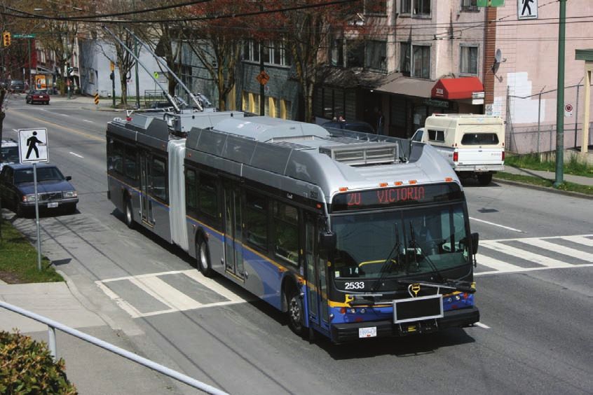
2. PURPOSE The purpose of this report is to document the findings of the Review of Alternatives for the Burnaby Mountain Gondola Transit Business Case. It expands upon the transit alternatives assessment discussed in the SFU Community Trust’s Initial Feasibility Study (IFS). The intent of this exercise is to narrow the transit technologies to be considered in Phase 2 – Design for Indicative Costing, by screening out technically infeasible and/or cost prohibitive alternatives. The report includes the following sections: Physical Constraints Review of Existing Transit Service Overview of Transit Solutions Secondary Screening Alternative Alignment Assessment Technology and Alignment Conclusion 412504_TBG011911024037VBC 2-1
3.            PHYSICAL CONSTRAINTS
There are a number of physical conditions that place constraints on potential transit
solutions.

3.1           Road Network
The road network serving Burnaby Mountain is shown in the map below.
Exhibit 3-1 – Road Network within Study Area

Road access to SFU is limited to Hastings Street/Burnaby Mountain Parkway from the west
and Gaglardi Way from the south. These two routes intersect with University Drive East to
form the primary access point to the campus. From this intersection, traffic can travel on
University Drive East to enter either the eastern or western/northern sides of the campus.
Just east of Duthie Avenue, Hastings Street becomes Burnaby Mountain Parkway and
provides access to the SFU campus for traffic originating from northern Burnaby and
Vancouver. Between Duthie Avenue and Gaglardi Way, the route has an overall elevation

412504_TBG011911024037VBC                                                                3-1
BURNABY MOUNTAIN GONDOLA TRANSIT                                                 PHYSICAL CONSTRAINTS

change of approximately 240 m and experiences grades of 6.5 to 7 percent over an
approximate length of 2.2 km.
Gaglardi Way is the primary route used by traffic originating from the regions to the south
and east of Burnaby Mountain. A major component of the traffic using this route is coming
from Highway 1 via the Gaglardi Way interchange. Between the Lougheed Highway/
Gaglardi Way intersection and the Burnaby Mountain Parkway/Gaglardi Way Intersection,
there is an approximate elevation change of 330 m. The first section of this route, between
Lougheed Highway and the intersection of Gaglardi Way and Broadway (which becomes
Como Lake Avenue to the east of North Road), is approximately 1.7 km long and
experiences grades of 1.5 to 3 percent. The second section, between Broadway and
Burnaby Mountain Parkway, is approximately 2.7 km long and has a continuous grade of
approximately 7.5 percent.
From the Gaglardi Way/Burnaby Mountain Parkway intersection, traffic can travel eastbound
along University Drive East for approximately 1.7 km to reach the eastern access of the SFU
campus. The average grades along this route are 7 percent. As an alternative, traffic can
travel northbound on University Drive East for approximately 1.3 km to enter the western/
northern side of the campus. The average grades along this route are approximately
6 percent.

3.2           Surrounding Land Uses
Near the Production Way – University Station (the nearest SkyTrain station to the mountain):
the areas adjacent to the Millennium Line are zoned for industrial and commercial use and
are part of Burnaby’s Lake City business centre area. This area is characterized by low- to
mid-rise warehouse-type and commercial buildings.
North of the business centre area, the zoning transitions to primarily residential use,
featuring attached housing in the Forest Grove neighbourhood.
The Lake City Way Station area is also generally zoned for industrial and commercial use as
part of the Lake City business centre. Charles Rummel Park lies immediately south, across
Lougheed Highway, from the station. Petroleum product tank farms begin about 850 m
upslope of the station.
Near the future Burquitlam Station, the area fronting on to Clarke Road is zoned for
commercial use. Further northwest the zoning transitions to residential use, primarily in the
form of detached homes.
The green zone surrounding SFU and UniverCity is classified as the Burnaby Mountain
Conservation Area. This area includes various tributaries and creeks of environmental
significance as well as an extensive trail network that is well used by hikers and mountain
bikers.

412504_TBG011911024037VBC                                                                         3-2
4.            REVIEW OF EXISTING TRANSIT SERVICE
Existing transit service to Burnaby Mountain consists of four bus routes: 135, 143, 144, and
145. Of those four routes, route 145 is most directly linked to the current rapid transit
network, via the Millennium Line. All four routes follow a figure-eight routing on the
mountain, first arriving at the SFU Transportation Centre at the west end of the academic
campus. They then continue to the terminus at the SFU Bus Exchange, where layover and
recovery time are taken at the eastern edge of the academic campus and adjacent the
western end of UniverCity. A straight-line distance of 550 m separates the Transportation
Centre and the Bus Exchange. Buses then leave the Bus Exchange, serve the south-
eastern edge of the campus, pass through the Transportation Centre, then serve the
extreme west end of the campus, where most student residences are located, before
proceeding off the mountain.
This section presents a brief description of each route, as well as a breakdown of the
relative proportion of Burnaby Mountain ridership served. An excerpt of the regional transit
map below illustrates the routes described.
Exhibit 4-1 – Map of Existing Burnaby Mountain Bus Routes

412504_TBG011911024037VBC                                                                      4-1
BURNABY MOUNTAIN GONDOLA TRANSIT REVIEW OF EXISTING TRANSIT SERVICE
4.1 Existing Bus Routes
Bus route 145, the busiest transit route serving Burnaby Mountain, links the SFU Bus
Exchange to the Production Way – University SkyTrain Station on the Millennium Line
and carries half of the transit commuters to and from the mountain. The route from
SkyTrain to the Bus Exchange is approximately 7.1 km, vs. a straight-line distance of
2.7 km. Travel time varies by time of day and passenger volume but 15 minutes is
typical. This route is typically operated with articulated buses.
The second-highest ridership bus, route 135, carries commuters to and from downtown
Vancouver along Hastings Street. This route requires over twice as many buses as route
145 at peak hours due to the much longer travel time from downtown, though ridership
to SFU is half that of route 145. Much of the service provision on this route is driven by
the downtown-related demand at the western end of the route. This route is typically
operated with articulated buses.
Bus route 144 travels from Metrotown Station to the Sperling – Burnaby Lake SkyTrain
Station on the Millennium Line in 26 minutes and then continues to the SFU Bus
Exchange in an additional 19 minutes. The low passenger loads of route 144, with less
than one-tenth of the total ridership to and from Burnaby Mountain, can be explained by
the fact that the commuting time from Metrotown to Production Way via SkyTrain and
then by bus to the SFU Bus Exchange is a shorter duration. As a result, route 144
ridership is likely limited to passengers accessing mid-route at local stops away from a
SkyTrain station. However, crowding on the 145 may lead some passengers to divert to
the 144, despite its lower frequency and longer travel time. This route is operated with
standard buses.
Route 143 from Coquitlam Station is the only direct transit service to and from Burnaby
Mountain for the Tri-cities region (Coquitlam, Port Coquitlam, and Port Moody). This
route, a 35-minute bus trip at peak times, will eventually be partially replaced by the
Evergreen Line extension, with the plan being for a revised 145 to be extended to
Burquitlam Station from the SFU Bus Exchange, leaving the 143 as a local route along
Como Lake Avenue between Coquitlam Centre and Burquitlam. This route is typically
operated with a mix of standard and articulated buses.
4.1.1 Proportion of Service
The current alternatives assessment focuses on the key linkage to Burnaby Mountain,
namely bus route 145 which carries half of the daily ridership. The following table shows the
ridership of each bus route serving the mountain, the share of total transit trips to and from
the mountain that it accounts for, the share of riders using that route that are related to
mountain trips (i.e., the number of daily riders on that route travelling to and from the
mountain divided by the route’s total boardings), and the number of buses assigned to each
route. The data shown is for fall 2009; preliminary fall 2010 data show little change in the
figures.
412504_TBG011911024037VBC 4-2BURNABY MOUNTAIN GONDOLA TRANSIT REVIEW OF EXISTING TRANSIT SERVICE
Exhibit 4-2 – Current (2009) Bus Ridership on Burnaby Mountain Routes
Share of Share of
Transit Route Riders Current
Bus Trips Route Daily Related to Peak Bus
Route Origin: to/from SFU to/from SFU Ridership SFU Allocation
135 Burrard Station (via
27% 21,900 31% 22
Hastings Street)
143 Coquitlam Station 12% 4,500 69% 6
144 Metrotown Station 10% 6,600 39% 10
145 Production Way –
50% 13,300 95% 10
University Station
4.2 Capacity Requirements
A number of travel demand model runs have been conducted to forecast ridership demand
to Burnaby Mountain. The findings to date are summarized in Tables 4.2 and 4.3 below. In
order to determine the demand for rapid transit, the model runs assumed similar operating
characteristics as the gondola described in the conclusions of the IFS, in other words, a
non-stop connection between Production Way – University Station and the SFU Bus
exchange. This establishes the level of demand that the technology solutions should have
the capacity to meet but allows for the analysis to be repeated should the assessment
suggest a different technology/alignment combination with differing performance
characteristics should also be examined.
For modelling purposes, the rapid transit link was assumed to operate with a vehicle
departing every 34 seconds and offer a one-way travel time of 7 minutes. Bus service levels
in the model were kept at a very high level to assess the maximum bus service demand that
might remain following introduction of a rapid transit link. The bus service levels in the
scenarios with the Evergreen Line were based on the bus integration plan for the Evergreen
Line and therefore assume that route 145 is extended to operate between Production Way
and Burquitlam stations, via SFU, replacing the 143 between SFU and Burquitlam.
Ridership forecasts include the horizon years 2021 and 2041. The basis of comparison in
each scenario is defined as a Business as Usual (BAU) scenario and represents the
anticipated transit service if buses remain the key transit service serving Burnaby Mountain.
The findings indicate the following:
The observed diversion from BAU bus service to gondola is significant, with over 80% of
Burnaby Mountain transit trips expected to use the rapid transit link
The peak hour volumes are generally consistent with the expected volumes described in
the IFS
The overall diversion of bus ridership to the rapid transit link is considered to be
conservative, since the frequency of competing bus service has not been optimized in
order to illustrate the effectiveness of rapid transit relative to intense parallel bus service
Demand for the rapid transit link is only slightly lower in the absence of the Evergreen
Line, with peak rapid transit volumes in 2041 without the Evergreen Line being 92% of
those with the Evergreen Line
412504_TBG011911024037VBC 4-3BURNABY MOUNTAIN GONDOLA TRANSIT REVIEW OF EXISTING TRANSIT SERVICE The preliminary findings from the model runs (with Evergreen Line) were used to define the required system capacity: that is, 2021 peak requires 2,900 passengers per hour per direction (pphpd) and 2041 peak requires 3,400 pphpd. Note that the peak AM hour load figures in the tables are for the peak location, wherever it occurs on the route. For the 135 this location is close to downtown Vancouver, so the service requirements are driven by that end of the route and not by Burnaby Mountain demand. The model results suggest that implementation of a gondola (or other rapid transit technology with similar travel time and frequency) between Production Way – University Station and Burnaby Mountain would allow the elimination of route 145 in all with rapid transit scenarios given the small demand that remains for it. The local stops served by the 145 near Production Way – University Station are also served by routes 110 and 136 and these would continue. (Customers using the sole unique 145 stop at NB Gaglardi at Broadway (near Centaurus Circle) would be required to walk to route 136 stops on Forest Grove Drive or route 110 stops on Eastlake. The affected area would still be largely within 400 m of transit service at these stops.) Route 144 between Sperling – Burnaby Lake Station and Burnaby Mountain would also continue in order to maintain a direct service to Burnaby Mountain from the residential area south of Hastings, to provide local service on the Burnaby Mountain summit plateau, and to provide an alternative to the gondola for passengers who have concerns about riding it. The without Evergreen Line scenarios show a modest reduction in demand for the 143 to SFU but this is not sufficient to assume that it can be removed, as a scenario that did remove it showed a reduction in travel time benefits. Consequently, the study has assumed retention of the 143 when evaluating the without Evergreen Line scenarios. 4.3 Travel Time and Transit Service Requirements A key objective of any rapid transit system is a reduction in travel time to and from desired destinations. For this reason, an adequate solution is one that has a travel time that is no longer than the existing bus connection between SFU and the Production Way – University SkyTrain Station, currently 13-16 minutes via route 145. A relatively unique factor in providing transit service to Burnaby Mountain is the comparatively severe winter weather experienced on the mountain. The mountain experiences snowfalls more often than other key destinations and the road network serving it is particularly susceptible to disruption in these conditions due to its exposure and grades. Transit service to the mountain is estimated to be affected to varying degrees 10 days every winter. This can range from substitution of standard buses for articulated buses, due to the poor handling of the latter in slippery road conditions, to a complete curtailment of transit service due to poor conditions and blockage of the roads by stuck vehicles. 412504_TBG011911024037VBC 4-4
BURNABY MOUNTAIN GONDOLA TRANSIT REVIEW OF EXISTING TRANSIT SERVICE
Exhibit 4-3 – Ridership Forecasts with Evergreen Line
BAU (Without Gondola) With Gondola
Peak AM Peak Estimated Peak Peak AM Peak Estimated Peak
Headway Hour Daily Volume Headway Hour Daily Volume
Year Route Service (min) Boardings Boardings (pphpd) (min) Boardings Boardings (pphpd)
135 SFU – Downtown 4.0 2,081 24,200 946 4.0 1,420 16,500 421
144 Metrotown Stn – SFU 10.5 1,119 13,000 293 10.5 1,079 12,600 293
145EG Production Stn – SFU –
2021
3.0 2,045 23,800 1,049 3.0 78 900 48
Burquitlam Stn
BMGT Burnaby Mtn Gondola n/a n/a n/a n/a 0.6 3,255 37,900 2,844
135 SFU – Downtown 3.0 2,379 27,700 988 3.0 2,124 24,700 558
144 Metrotown Stn – SFU 8.0 1,620 18,900 492 8.0 1,598 18,600 492
145EG Production Stn – SFU –
2041
2.5 2,657 31,000 1,282 2.5 107 1,200 60
Burquitlam Stn
BMGT Burnaby Mtn Gondola n/a n/a n/a n/a 0.6 4,174 48,600 3,341
pphpd: passengers per hour per direction
Exhibit 4-4 – Ridership Forecasts without Evergreen Line
BAU (Without Gondola) With Gondola
Peak AM Peak Estimated Peak Peak AM Peak Estimated Peak
Headway Hour Daily Volume Headway Hour Daily Volume
Year Route Service (min) Boardings Boardings (pphpd) (min) Boardings Boardings (pphpd)
135 SFU – Downtown 4.0 2,070 24,100 891 4.0 1,440 16,800 437
143 Coquitlam – SFU 8.0 578 6,700 373 8.0 441 5,100 344
144 Metrotown Stn – SFU 10.5 1,139 13,300 286 10.5 1,080 12,600 287
2021
145 Production Stn – SFU 3.0 1,594 18,600 1,462 3.0 3 0 2
BMGT Burnaby Mtn Gondola n/a n/a n/a n/a 0.6 3,129 36,500 2,625
135 SFU – Downtown 3.0 2,487 29,000 941 3.0 1,833 21,400 608
143 Coquitlam – SFU 7.0 715 8,300 412 7.0 482 5,600 356
144 Metrotown Stn – SFU 8.0 1,698 19,800 483 8.0 1,591 18,500 485
2041
145 Production Stn – SFU 2.5 1,983 23,100 1,709 2.5 5 100 4
BMGT Burnaby Mtn Gondola n/a n/a n/a n/a 0.6 4,020 46,800 3,062
pphpd: passengers per hour per direction
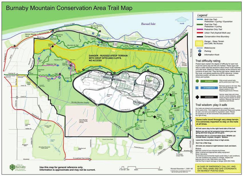
412504_TBG011911024037VBC 4-5BURNABY MOUNTAIN GONDOLA TRANSIT REVIEW OF EXISTING TRANSIT SERVICE 4.4 Multi-Modality The following extract from the City of Burnaby’s Cycling Map shows a mix of shared vehicle/bicycle roadways and urban trails in the vicinity of Burnaby Mountain. Use of the current system for commuting to SFU is limited due to the steep grades. Recreational use of the trail network on Burnaby Mountain, as shown in the second map, by mountain bikers is high. Many recreational downhill cyclists are observed using bus bike racks to ascend the mountain. Improved multi-modal accessibility of the transit system could increase ridership for bicycle commuters and recreational riders alike. Exhibit 4-5 – Shared Vehicle/Bicycle Roadways and Trails 412504_TBG011911024037VBC 4-6
BURNABY MOUNTAIN GONDOLA TRANSIT                             REVIEW OF EXISTING TRANSIT SERVICE

Exhibit 4-6 – Burnaby Mountain Conservation Area Trail Map

412504_TBG011911024037VBC                                                                   4-7
5.            OVERVIEW OF TRANSIT SOLUTIONS
This section provides high level commentary and initial screening of the potential transit
solutions for Burnaby Mountain. Included are descriptions of the base case, i.e., the current
service provided by diesel buses, ground-based transit, and aerial solutions. It must be
noted that all the assessments are relative to this application, its constraints, and the range
of other technologies being examined. Other studies reviewing the same technologies in
other corridors could reach different conclusions depending on local conditions.
At this stage, a primary screening phase is used to filter out alternatives that are not
technically viable. Alternatives that appear viable proceed to the Secondary Screening for
evaluation in greater detail
The evaluation is done on a primarily qualitative basis, with select criteria being quantified or
monetized where possible. The results of the comparison are summarized in a structured
format to facilitate understanding and decision-making.

5.1           Primary Screening Evaluation Criteria
The primary screening phase is intended to exclude technically infeasible solutions from
further consideration. The alternatives are rated against the following pass/fail criteria:

Travel Time
The travel time to commute between Production Way - University Station and the SFU Bus
Exchange on a diesel bus along route 145, i.e. the base case, is 15 minutes excluding
boarding and alighting times. Does the alternative offer travel time savings, or at least equal
performance compared to the base case? Any alternative that takes longer than 15 minutes
will fail this test.

Operating Limit
Does the expected alignment/operation of a particular alternative fall within the operating
parameters of that technology? This test accounts for factors such as maximum allowable
grade, minimum allowable turning radius, and passenger capacity.

Surface Impact
Are the topographic, property and/or environmental impacts of the alternative too great to
overcome; that is, without provision of prohibitively costly mitigation measures?

412504_TBG011911024037VBC                                                                      5-1
BURNABY MOUNTAIN GONDOLA TRANSIT OVERVIEW OF TRANSIT SOLUTIONS
5.2 Base Case – Diesel Bus
Exhibit 5-1 – Articulated Diesel Bus Serving SFU
Diesel buses are the workhorses of TransLink’s fleet, and they have served Burnaby
Mountain for decades. However, current demand and forecast growth put pressure on this
system which is already over capacity on certain routes, namely 145, as evidenced by
queuing and pass-ups during peak periods.
The 60 foot diesel buses currently used on the 145 are capable of carrying approximately
1,700 passengers per hour during peak periods, at a headway of approximately 3 minutes
(17 trips/hour currently scheduled). The peak capacity is insufficient to meet the projected
demands in 2021 and 2041. The capacity for this route could be improved by increasing the
frequency during peak periods, following a BRT model.
Further study is required to determine the necessary reduction in headway. However, when
factoring in boarding/alighting time, it is possible that buses may need to run without layover
and with minimal recovery time during peak periods. The increased cost and complexity of
operating in this fashion, combined with the socio-economic impacts on residents and the
local environment demonstrates the need to review other, higher capacity technologies.
Other issues associated with diesel buses for Burnaby Mountain include:
Diesel drive is not well not suited for hilly terrain with high passenger volumes, especially
in winter conditions.
Traffic impacts and noise would be exacerbated if operating at increased frequencies.
Diesel propulsion is associated with greenhouse gas (GHG) and criteria air
contaminants (CAC).
412504_TBG011911024037VBC 5-2BURNABY MOUNTAIN GONDOLA TRANSIT OVERVIEW OF TRANSIT SOLUTIONS
Diesel is a non-renewable, fossil fuel resource that is subject to future supply scarcity
and price volatility. Since a large portion of TransLink’s fleet is dependent on diesel as a
mobile fuel source, it would be prudent to explore alternatives to diesel in this setting.
Scheduling and driver requirements with very frequent bus service result in a need for
extensive layover/recovery facilities, which are land extensive and costly to provide in
urban settings.
Operating costs are largely directly proportional to the capacity of service provided,
particularly when articulated buses are already employed.
While it may be technically feasible to meet capacity demands using diesel buses, the
associated problems and costs of doing so call for consideration of alternative high-capacity
systems.
5.3 Ground-Based Solutions
The following subsections describe ground-based transit alternatives. Alternatives that are
technically infeasible are screened out from further consideration. All ground-based
solutions, unless they are completely grade-separated, are subject to roadway congestion.
By nature, ground-based alternatives would require additional property for their rights-of-
way, increasing property requirements and affecting the conservation area. Although transit
signal priority measures could be implemented to reduce travel times on existing roads,
there are relatively few signals on the route, thus limiting the potential benefits.
5.3.1 BRT – Trolleybus
Exhibit 5-2 – TransLink Articulated Electric Trolleybus
412504_TBG011911024037VBC 5-3BURNABY MOUNTAIN GONDOLA TRANSIT OVERVIEW OF TRANSIT SOLUTIONS Benefits Trolleybuses offer broad environmental benefits including: elimination of diesel fuel consumption, reduction in both GHG and CAC emissions, longer vehicle life, better ride quality, as well as decreases in internal and external noise. Fuel switching from a fossil fuel (diesel) to renewable, hydroelectric power provides advantages in terms of system resilience and risk mitigation, though increasing electricity demand needs to be evaluated in concert with BC Hydro. In 2006-2008, TransLink replaced its aging trolleybus fleet with new state of the art trolleybuses. This reaffirmed that trolleybuses are a proven transit solution in the Lower Mainland, particularly for hilly terrain applications with high passenger volumes, where the electric drive provides more torque than a conventional diesel engine allowing better acceleration and higher speeds. Drawbacks Trolleybuses would encounter the same capacity-related problems as diesel buses. There may be opposition to the installation of trolley wires both leading up to Burnaby Mountain as well as to provide routing between Production Way and the nearest transit depot. Provision of redundant switching and higher maintenance requirements for the wires are also potential drawbacks. While trolleybuses are better suited to hilly terrain, the higher altitudes near the top of Burnaby Mountain are susceptible to heavier snowfall and thus excellent traction is required to maintain service. Driving the second and third axles of articulated trolleybuses is possible as a means to increase traction but they would still be susceptible to disruption from other traffic. Accumulation of frost and ice on the trolley wires prevents a good electrical contact being made and would be a common occurrence given the elevation. Conclusion Using trolleybuses to serve Burnaby Mountain yields the environmental benefits of fuel switching from diesel to electricity, e.g., reduced GHG, CAC, noise, etc. However, trolleybuses face the same capacity constraints as the base case, while offering little reduction in travel time. The community challenge of installing trolley wires, accommodating layover requirements, and operations and maintenance issues due to frost/ ice on trolley wires also limit the ability of trolleybuses to be the most effective alternative relative to others. Since the trolleybus alternative does not offer many advantages over the base case, it is not retained for further evaluation. 412504_TBG011911024037VBC 5-4
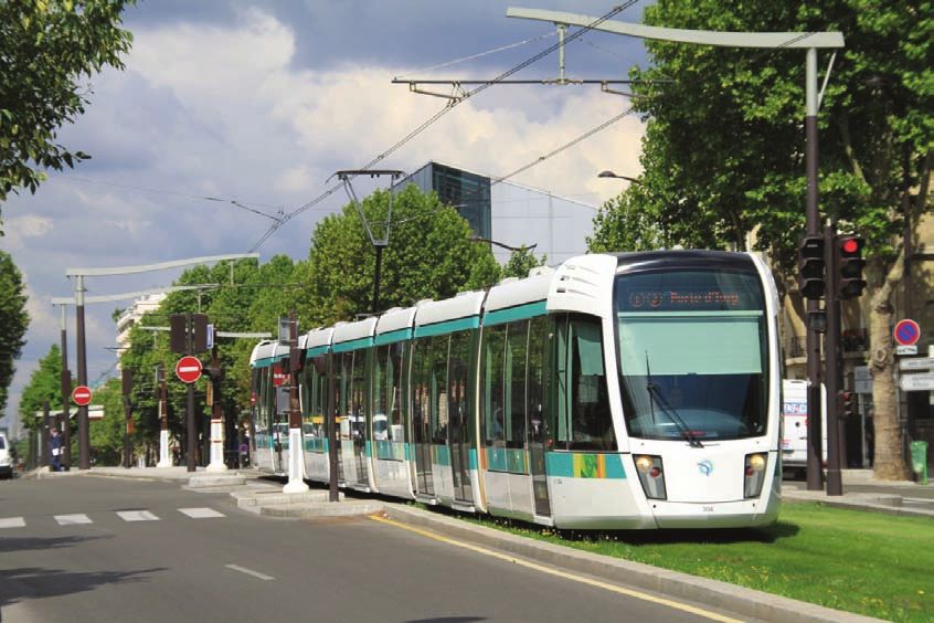
BURNABY MOUNTAIN GONDOLA TRANSIT                                           OVERVIEW OF TRANSIT SOLUTIONS

5.3.2         Light Rail Transit (LRT)
Exhibit 5-3 – LRT Train in Paris

Benefits
LRT has higher capacity than buses (up to 15,000 pphpd). Since LRT systems feature
embedded rails, they hold a subjective advantage over buses in terms of signalling a degree
of permanence to the development community and to discretionary riders.
LRT would carry similar benefits of fuel switching as the trolleybus alternative. The operating
speed (and travel time) would be similar to current traffic, although the introduction of transit
signal priority could result in a moderate improvement in travel time.
Similar to buses, LRT is driver operated.

Drawbacks
It is assumed that LRT would be operated within a dedicated right-of-way alongside existing
traffic. Property easements or full takes may be required along the route. Widening of the
right-of-way would also impinge on the Burnaby Mountain Conservation Area.
LRT systems are typically powered from an overhead wire. This would have similar issues
as described previously for trolley wires.
Road grades along Hastings Street and Gaglardi Way range from 7% to 9%, which exceeds
the recommended 6% operating parameter of typical LRT systems. Though the mechanical
systems can ascend steeper grades, there are consequent operational issues that would
increase long-term costs, particularly in light of snow conditions. Downhill speeds would
need careful regulation given the limited adhesion and extended stopping distances. Given
the grades, the LRT route would be no shorter than the exiting bus route, suggesting little
gain in travel time would be possible.

412504_TBG011911024037VBC                                                                            5-5
BURNABY MOUNTAIN GONDOLA TRANSIT                                              OVERVIEW OF TRANSIT SOLUTIONS

Looking specifically at the roadway alignments of Gaglardi Way and University Drive East,
the hairpin curves are not ideal for LRT operations, i.e. curves can be negotiated, but would
require operating at reduced speeds.

Conclusion
LRT would push beyond typically acceptable operational ranges, and would not garner
measurable benefits in terms of travel time. It is recommended that LRT be omitted from
further consideration.

5.3.3         Guided Light Transit (GLT)
Benefits
Several proprietary systems of this type exist but all are rubber-tired and use a track for
guidance. Rubber tires allow it to go up steeper grades than LRT, and allow vehicles to
travel off of the embedded guide track when needed, offering greater system flexibility.
Capacity is slightly less than articulated LRT vehicles (less than 15,000 pphpd).
GLT was at one time considered for the Evergreen Line. The following is an excerpt from
the Northeast Sector Rapid Transit Alternatives Project – Phase 2 – Evaluation of Rapid
Transit Alternatives Study:
          The guided light transit vehicle is similar to a shorter version of the articulated
          LRT vehicle, has similar multiple-door configuration, but operates on rubber
          tires. As such, the GLT operates on paved roadways, either in mixed traffic or
          in a separate right-of-way. The guidance systems are either optical magnetic
          or mechanical. They permit operators to dock at stations with small
          clearances to platforms, reducing boarding time, and to drive at higher
          speeds within narrower rights-of-way than bus vehicles. The GLT is normally
          diesel powered, but could also have electric motors and obtain power from
          overhead power lines, or could be dual, diesel and electric powered for
          on-line and off-line operation. GLT vehicles can carry approximately 100
          passengers each and cost approximately $2 million per vehicle or $20,000
          per passenger.

Drawbacks
Other installations have encountered mechanical problems, guidance issues, and wheel
rutting in pavement. These operations and maintenance issues have deterred wide adoption
of this technology. A GLT alignment to SFU would require a separate alignment protected
from other traffic, imposing its own snow removal issues as well as property requirements
and environmental concerns.

Conclusion
GLT can operate on steeper grades, but carries the same disadvantages outlined for LRT. It
is recommended that GLT be omitted from further consideration.

412504_TBG011911024037VBC                                                                               5-6
BURNABY MOUNTAIN GONDOLA TRANSIT OVERVIEW OF TRANSIT SOLUTIONS 5.3.4 Funicular Exhibit 5-4 – Funicular (Hungerbergbahn) in Innsbruck, Austria Benefits Funiculars use railway cars that are connected to each other by a cable looped around the upper station of the route, allowing one car to ascend while the other descends. Some systems use a single car with a counter-weight replacing the second car. They are ideal for constant steep grades and can contain horizontal curves in their alignment. Generally, a single track is used for the majority of the route, with a double track at the mid-point to allow for passing of the two cars. Because they operate at ground level and do not rely on wheel/rail adhesion for traction, funiculars can operate in all weather conditions if the tracks are cleared. Drawbacks Funiculars require land for their track, which poses a problem since there is no obvious right-of-way that can be followed to reach the SFU Bus Exchange. Any direct or indirect route would have significant impacts to existing development, Gaglardi Way, and the Burnaby Mountain Conservation Area, and carry with it commensurate capital costs. Another disadvantage of a funicular occurs when the grade varies along the route, which results in the funicular floor not remaining level unless special measures are taken, such as cabins on gimbals, adding complexity and cost and reducing capacity. Since funiculars employ two cabins running in opposition, the potential frequency and thus capacity is a direct function of the route length and speed – the longer the route, the lower 412504_TBG011911024037VBC 5-7
BURNABY MOUNTAIN GONDOLA TRANSIT                                          OVERVIEW OF TRANSIT SOLUTIONS

the capacity that can be provided. The route to Burnaby Mountain is too long for a funicular
providing the required capacity. At the typical speed of 25 km/h over 2.7 km, the round trip
cycle would be about 10 minutes. Assuming the maximum precedent car capacity of 400
passengers, this would result in a capacity of 2,400 pphpd, which is below the projected
demand in 2021. The potential headway of a departure every 10 minutes would also be a
significant drawback, providing lower frequency than the bus in the base case.

Conclusion
The absence of an obvious constant grade right-of-way, the long route length of more
available rights-of-way, and the large land impacts and resulting costs offset the benefits of
this technology for a Burnaby Mountain application. The capacity that can be provided is
also below anticipated demand so funiculars are excluded from further consideration.

5.3.5         Rack Railway
Exhibit 5-5 – Rack-equipped Metro Line in Lyon, France

Benefits
Rack railways are rail systems that ascend steep grades using a rack and pinion system for
traction power. With this form of traction they can climb much steeper grades than standard
railways though speeds are limited. If right-of-ways were available, a rack railway could
ascend directly up Burnaby Mountain. A rack railway would have the ability to operate more
frequent service than a funicular, since more than two trains could be operated
simultaneously.

Drawbacks
A rack railway would need more right-of-way than a funicular since more of the line would
need to be double-tracked to allow operating flexibility but no suitable right-of-ways exist.

412504_TBG011911024037VBC                                                                           5-8
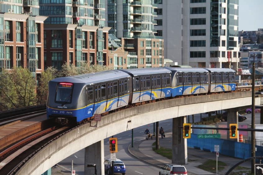
BURNABY MOUNTAIN GONDOLA TRANSIT                                            OVERVIEW OF TRANSIT SOLUTIONS

Additionally, the cars/trains would be relatively large suggesting that significantly less
frequent, and thus less attractive, service than offered by buses would be provided.

Conclusion
Rack railways are excluded from further consideration due to the lack of suitable right-of-
ways up Burnaby Mountain (as with the funicular system).

5.3.6         Rail Rapid Transit (SkyTrain)
Exhibit 5-6 – SkyTrain near Main Street – Science World Station

Benefits
SkyTrain is a proven technology in the region, and forms the backbone of TransLink’s rapid
transit system. The SkyTrain network already operates within 2.7 km of the mountain.

Drawbacks
SkyTrain is not technically reasonable on this route given its operating grade limitation of
6%, high capital cost, environmental impacts (including a large number of columns that
would need to be erected within the Burnaby Mountain Conservation Area), and difficult
system integration, e.g., building switches to branch off the Millennium Line while
maintaining service. The technology is also capable of providing vastly more capacity
(25,000+ pphpd) than this application requires. A potential benefit of SkyTrain would be to
have direct trains to Burnaby Mountain from elsewhere on the network but this would be
challenging to integrate in an already complex network.

Conclusion
The drawbacks above preclude SkyTrain from further study.

412504_TBG011911024037VBC                                                                             5-9
BURNABY MOUNTAIN GONDOLA TRANSIT                                            OVERVIEW OF TRANSIT SOLUTIONS

5.3.7         Personal Rapid Transit (PRT)
Benefits
Personal rapid transit is based on small, automated vehicles operating on a dedicated
network of guideways. The premise of these systems is that they can provide high
frequency, on-demand service with a high degree of privacy given the small vehicles and,
ideally, point-to-point service without intermediate stops. They are meant to function like a
horizontal elevator and provide a level of service like that of a private automobile but as a
public transit service. Relatively few PRT systems are in regular operation with the best
known one being in Morgantown, West Virginia. New systems have recently opened in
Masdar City, UAE; and a prototype as a parking shuttle at London’s Heathrow Airport.

Drawbacks
Very few PRT systems are in operation and all are unique so it is difficult to identify “typical”
characteristics. PRT systems are optimally deployed where there is moderate demand
among a group of origins and destinations, which is not the case for this higher volume,
point-to-point application. The capacity required here is also approaching the limit of what
has been identified as reasonable for many systems, and likely exceeds it. Further, PRT
systems need alignments (typically elevated) that are independent of other traffic and so
incur surface impacts, albeit these are intended to be a lower scale than for other
ground-level technologies.

Conclusion
PRT is not considered suitable for this application as the ridership demand is higher than
such systems are designed for and the point-to-point nature of demand would not play to
PRT’s strengths.

5.3.8         Escalator
Benefits
Public escalators are commonly used to handle low-speed short-distance vertical transitions
in urban areas. They are a familiar and proven technology.

Drawbacks
The distance from any possible escalator base terminal to the top of Burnaby Mountain
would result in a route with a travel time three to four times longer than the current bus
service, and with large land requirements and environmental effects.

Conclusion
Escalators offer non-competitive travel times and high surface impacts and so are excluded
from further study.

412504_TBG011911024037VBC                                                                            5-10
BURNABY MOUNTAIN GONDOLA TRANSIT                                                                                                                            OVERVIEW OF TRANSIT SOLUTIONS

5.3.9           Ground-based Conclusions
Exhibit 5-7 summarizes key capabilities of the ground-based systems. None of the ground-based alternatives offer significant
benefits with acceptable impacts relative to the base case.
Exhibit 5-7 – Table of Ground-Based Technologies Assessed
                       Diesel Bus       Trolleybus
                         (artic)          (artic)            LRT                GLT             Funicular        Rack Railway          SkyTrain             PRT             Escalator

Typical Mode of             Driver         Driver           Driver             Driver           Operator/            Driver           Driverless         Driverless         Driverless
Operation                                                                                       Attendant
Level of              Mixed traffic     Mixed traffic     Priority/          Priority/            Fully              Fully              Fully              Fully              Fully
Segregation                                              Segregated         Segregated         Segregated         Segregated         Segregated         Segregated         Segregated
Land                  Existing road    Existing road    Exclusive right-   Exclusive right-   Exclusive right-   Exclusive right-   Exclusive right-   Exclusive right-   Exclusive right-
Requirements            network          network            of-way             of-way             of-way             of-way             of-way             of-way             of-way
Maximum                      12%        Up to 23%            10%                13%               128%                48%                 6%                10%                60%
Gradient
Capacity                  2,400            2,400           1,200 to           1,200 to             3,000            1,200 to            25,000         1,000 to 7,000     1,000 to 3,500
(passengers/            (existing)                         15,000             15,000           (depends on          15,000
hour/direction)                                                                                   length)
Capacity per car             100            100           200 to 250         200 to 250             400            200 to 250             130               4 to 6              n/a
(approx)
Accessibility               Ramp           Ramp         Level boarding     Level boarding       Potentially        Potentially      Level boarding     Level boarding     Level boarding
                                                                              or ramp         level boarding     level boarding
Depot Facilities            Off-line      Off-line          On-line            On-line            On-line            On-line            On-line            Off-line           Off-line
Maximum Speed        Posted speed      Posted speed        80+ km/h           80 km/h            50 km/h            25 km/h            90 km/h            50 km/h           1 to 2 km/h
Motive Power          Diesel/Hybrid       Electric          Electric       Diesel/Electric        Electric         Electric or          Electric           Electric           Electric
                                                                              Hybrid                                 Diesel
Evacuation              Window/          Window/           Window/            Window/            Window/            Window/            Window/            Window/             Stairs
                       self-rescue      self-rescue       self-rescue        self-rescue        self-rescue        self-rescue        self-rescue        self-rescue
Safety/Security             Driver         Driver           Driver             Driver           Attendant            Driver           Attendant          Camera/            Camera/
(all can have                                                                                                                                            Attendant          Attendant
CCTV,
intercoms)
Heating/Ventilati      Heating/AC       Heating/AC       Heating/AC         Heating/AC           Heating          Heating/AC         Heating/AC         Heating/AC           Weather
on                                                                                                                                                                           protected
Vehicle Life         12 to 15 years    15 to 17 years     30+ years        15 to 17 years       30+ years          30+ years          30+ years                           20 to 30 years

412504_TBG011911024037VBC                                                                                                                                                                5-11
BURNABY MOUNTAIN GONDOLA TRANSIT OVERVIEW OF TRANSIT SOLUTIONS 5.4 Aerial Transit Solutions The following subsections provide details on potential aerial ropeway transit solutions. As opposed to ground-based transit, aerial transit is not affected by roadway conditions. As these are a closely related family of technologies, they are described individually but then assessed in detail in following sections. 5.4.1 Aerial Tram/Reversible Ropeway Exhibit 5-8 – Portland (Oregon) Aerial Tram Benefits Aerial Trams, also known as Reversible Ropeways, include two passenger cabins that hang on one or two track ropes. A haul rope that passes through a drive system at one of the terminals connects the two cabins and pulls one cabin up while lowering the other. To complete the system, a counter rope is tensioned between both cabins and the opposite terminal. Functionally the system is very similar to a funicular, except that the aerial track ropes replace ground-mounted rails. These tramways are capable of spanning great distances and can operate in extreme weather conditions, including periods of high winds, particularly if two track ropes are used. They are also highly reliable and can be used for applications requiring long operating hours and minimal downtime, something that would be a benefit to transporting people to and from Burnaby Mountain. 412504_TBG011911024037VBC 5-12
You can also read