Wellingborough Town Transport Strategy - Fit for Purpose Fit for Purpose - January 2015 - Northamptonshire ...
←
→
Page content transcription
If your browser does not render page correctly, please read the page content below
Wellingborough Town Transport Strategy

Wellingborough
Town Transport Strategy

Fit for Purpose

Fit for Purpose

                                         January 2015

                                                        1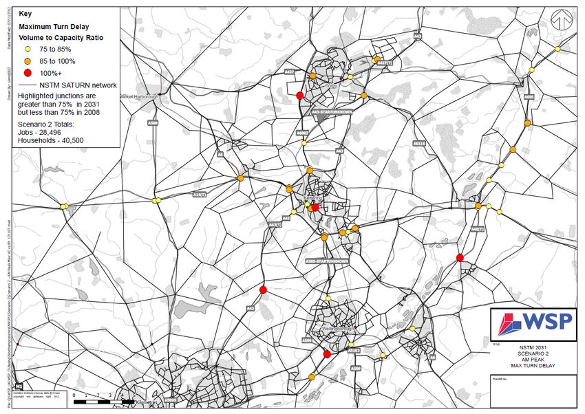
Wellingborough Town Transport Strategy

                                         (Blank Page)

                                                        2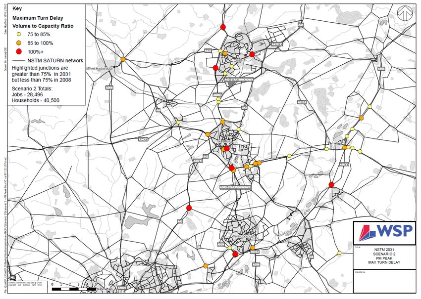
Wellingborough Town Transport Strategy

Wellingborough Town Transport Strategy

Contacts and Further Information
This is Northamptonshire County Council’s Wellingborough Town Transport Strategy.

It sets out the overarching vision for transport in Wellingborough and sets out our strategy to
achieve it. This strategy is one of a series of thematic daughter documents to the
Northamptonshire Transportation Plan that was adopted in April 2012.

Should you have any queries regarding this strategy, please contact the Transport Planning Team.

Transport Planning
Highways, Transportation and Infrastructure
Northamptonshire County Council
Riverside House
Northampton
NN1 5NX

Email: LTPconsultation@northamptonshire.gov.uk

                                                                                                   3
Wellingborough Town Transport Strategy

                                         (Blank Page)

                                                        4
Wellingborough Town Transport Strategy

Contents

    Chapter                                 Theme & Content   Page No.
       1          Northamptonshire Transportation Plan           7
       2          Introduction                                   11
       3          Identifying the issues - now                   17
       4          Future Growth                                  32
       5          The Transport Strategy for Wellingborough      37
       6          Delivery Plan                                  67

                                                                         5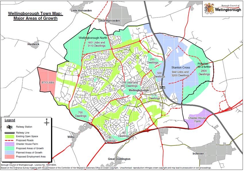
Wellingborough Town Transport Strategy

                                         (Blank Page)

                                                        6
Wellingborough Town
Wellingborough Town Transport Strategy

Chapter 1: Northamptonshire Transportation Plan: Fit for Purpose

Transportation is not an end in itself. The movement of people and goods takes place not for its
own sake, but to fulfil the diverse needs and desires of the public. Therefore the County Council’s
transport policies are similarly promoted for their effect on other specific goals, priorities and
objectives, rather than as an end in themselves.

                         Northamptonshire Transportation Plan Vision:

For Transport and Travel to contribute towards making Northamptonshire a great place to live and
work, through creating tangible transport options to satisfy individual needs and to encourage
more sustainable travel. The transport system will provide fast and efficient movement of people
and goods, and will be accessible for all. Expanding networks and capacity of networks in
Northamptonshire will be fully integrated into new developments and regeneration areas to
support more sustainable communities.

Economic growth and prosperity is a top priority for Northamptonshire and connectivity has a vital
role to play in encouraging businesses to locate to the area, and getting people to work and
services such as education and health, as well as to leisure activities and for shopping. Improved
technology and local accessibility will reduce the need to travel, whilst supporting economic
growth, within a low carbon environment and Northamptonshire will become an exemplar for the
latest developments in information technology, fuel technology, and new forms of transport.

The county council will work in partnership with all stakeholders and the wider community to
deliver this transport vision and strategy.

This transportation plan needs to be both aspirational and realistic at the same time. Current
economic climates mean that transport is certainly in a more austere time than in the last 15 to 20
years and this plan needs to reflect that but at the same time still plan for future growth.

                          The overall aim for this Transportation Plan is:
                     ‘Northamptonshire Transportation - Fit for..... Purpose’

The aim ‘fit for purpose’ means creating a network that delivers exactly what Northamptonshire
needs to be able to function plus what it needs to be able to grow.

This overarching aim can then be broken down into six objectives that have been chosen to guide
this Transportation Plan. These objectives have been drawn up to reflect the issues which have

                                                                                                 7
Wellingborough Town Transport Strategy

been identified as locally important through consultation, while at the same time reflecting wider
national and local policy context. These objectives have been deliberately chosen to reflect the
main impacts that transport can have on the wider community, rather than being linked to
particular schemes or measures. They form the basis upon which the policies and programmes
contained in this Plan have been developed.

1. Fit for.......the Future – creating a transport system that supports and encourages growth and
   plans for the future impacts of growth, whilst successfully providing benefits for the County.

2. Fit for.......the Community – through the transport system help to maintain and create safe,
   successful, strong, cohesive and sustainable communities where people are actively involved in
   shaping the places where they live.

3. Fit to.......Choose – ensuring that the people of Northamptonshire have the information and
   the options available to them to be able to choose the best form of transport for each journey
   that they make.

4. Fit for........Economic Growth – creating a transport system that supports economic growth,
   regeneration and a thriving local economy and successfully provides for population and
   business growth.

5. Fit for........the Environment – to deliver a transport system that minimises and wherever
   possible reduces the effect of travel on the built, natural and historic environment.

6. Fit for........Best Value - being clear about our priorities for investment and focusing on value
   for money by prioritising what we spend money on and how it can be beneficial for the county
   as a whole and search for alternative sources of funding.

The Northamptonshire Transportation Plan fits in with the Northamptonshire Arc, helps to deliver
the Core Spatial Strategies in West and North Northamptonshire and supports the work of the
Local Enterprise Partnerships.

                                                                                                  8
Wellingborough Town
Wellingborough Town Transport Strategy

Daughter Documents

This Strategy is the part of a series of documents which form the Northamptonshire
Transportation Plan ‘suite of documents’. This suite of documents includes strategies or plans
covering a range of transport themes and detailed geographic strategies or plans for
Northamptonshire’s main towns.

Thematic strategies or plans have been developed as daughter documents to the
Northamptonshire Transportation Plan, of which this Wellingborough Town Strategy is one.

Figure 1: Proposed Northamptonshire Transportation Plan suite of strategies

                                       Northamptonshire Arc

                           Northamptonshire Transportation Plan (2012)

                                         Daughter Documents
            Thematic Strategies                                     Town Strategies

  Freight                Parking                         Brackley
  Bus                    Rail                            Corby
  Walking                Cycling                         Daventry
  Air Quality            Road Safety                     East Northamptonshire
                                                         Kettering
  Smart Travel Choices                                   Northampton
  Transport Management                                   Towcester
  Highways Improvement                                   Wellingborough
  Development Management

Town Transport Strategies

This Town Transport Strategy has been developed to meet the needs of Wellingborough; to
coordinate the approach and shared commitment of all parties involved in both delivering the
improvements to and the provision of the transport and highways provision and infrastructure
within Wellingborough as it grows.

                                                                                            9
Wellingborough Town Transport Strategy

The following table shows how the Town Transport documents tie in with the six over-arching
Northamptonshire Transportation Plan objectives:

                                              Northamptonshire Transportation Plan Overarching Objectives
                              Fit for..... the    Fit for..... the     Fit to.....     Fit for..... Fit for..... the Fit for.....
                                  Future           Community             Choose       Economic      Environment          Best
                                                                                         Growth                         Value
                                The town             We have       The strategies       Ways of         The local         All
                                transport         worked with        consider the    tackling the    environment transport
                              strategies set       district and    improvements      congestion      in each town improve
                                  out the            borough            that are     that would      covered by a       ments
                                transport          councils to       necessary to     potentially     strategy will necessary
Town Transport Strategies

                             improvements            develop         increase the   be harmful to be improved           in the
                                 that are           strategies     attractiveness     economic      if the impacts      towns
                               required to          that allow      of sustainable     growth is     of traffic are   need to
                            support growth           towns to          transport    considered in       reduced.          be
                            as set out in the       grow into         modes and       the plans,                     impleme
                                   Local              strong,           increase      which also                         nted
                              Development            cohesive      accessibility of  set out the                        within
                            Documents with communities.                 services.      transport                          our
                                the Local                                           improvement                      budget or
                              Development                                            s needed to                          be
                            Frameworks for                                              increase                       funded
                              the area that                                            access to                         from
                               they cover.                                          employment.                         other
                                                                                                                      sources.

                                                                                                                             10
Wellingborough Town
Wellingborough Town Transport Strategy
Chapter 2: Introduction
The Wellingborough Town Transport Strategy establishes Northamptonshire County Council’s
vision for transport in Wellingborough to 2031, to support the town’s economic prosperity and
well-being.
The strategy presents a combination of short to medium term interventions and long term
aspirations for all modes to deliver a highway and transport network which meets future travel
demand. The strategy is supported by the twelve thematic strategies that make up the
Northamptonshire Transportation Plan suite of documents which cover; freight, bus, rail, walking,
cycling, air quality, smarter travel choices, development management, highway improvement,
road safety and parking. These strategies set out the County Council’s vision for each transport
related topic area, and therefore should be read in conjunction with this document.
The strategy is based on meeting the growth aspirations for Wellingborough to 2031 which are
outlined in the Emerging Joint Core Strategy 2011-2031 and due to be adopted in 2015. The
strategy is based on the most recent housing and employment assumptions which have been
published by the Joint Planning Unit.
The Borough Council of Wellingborough is currently in the process of developing a Plan for the
Borough of Wellingborough which will replace the policies in the Town Centre Area Action Plan
(TCAAP) and the saved policies from the Local Plan.
The Plan for the Borough of Wellingborough will guide the proposals for the Borough of
Wellingborough over the next 15 years and will supplement the strategic policies in the Joint Core
Strategy. As part of the Plan for the Borough of Wellingborough, the aspirations for the town
centre in particular are being revisited. The County Council will work with the Borough Council of
Wellingborough in identifying the transport and highways necessary to support the future
aspirations for the town centre. This strategy therefore is an interim document which will be
revisited and amended in line with the timescales for the development of the Plan for the Borough
of Wellingborough.
The strategy has been produced by the County Council in partnership with the Borough Council of
Wellingborough and othr key stakeholders and shaped through feedback from public consultation.
11Wellingborough Town Transport Strategy
Context
Wellingborough is a market town located in Northamptonshire and lies about 65 miles from both
London and Birmingham, with a population of just over 75,000. By 2021 its population is projected
to grow to just over 80,0001.
Wellingborough benefits from good road connections. The A45 provides an east-west route to the
M1 at Northampton and the A14 to the east for connections to the East Coast Ports. The A509
provides a north-south route, which links via the A14 to the M1 and M6. Wellingborough is on the
Midland Main Line railway which provides a regular service to London and other cities such as
Nottingham and Leicester. The average journey time to London St Pancras is 55 minutes.
For the past decade Wellingborough has been identified as a growth area and transport modelling
has shown that this increase in population and supportive job creation will result in an increased
demand for travel which will put particular pressure on the town centre and the inter-urban
routes connecting Corby, Kettering and Wellingborough. To this end, the strategy focuses on
existing urban area of Wellingborough, together with the sustainable urban extensions identified
in the adopted Core Spatial Strategy; namely Wellingborough East and Wellingborough North. For
the County Council’s plans for investing in the inter-urban network please refer to the
Northamptonshire Major Roads Strategy, Bus Strategy and Rail Strategy.
Aims and objectives
The aim of the Wellingborough Town Transport Strategy is to enhance the highway and transport
network through implementation of sustainable transport measures and highway capacity
enhancements to support the delivery of Wellingborough’s regeneration and economic growth to
make Wellingborough more self-sustaining, attract inward investment and meet the increased
travel demand.
The key objectives of the strategy are to:
Encourage a shift towards sustainable transport;
Support the regeneration of Wellingborough as a destination for retail, leisure and
employment activity through improved transport links and enhancements to the public
realm and to enhance its economic competitiveness and growth through a programme of
1
Sub-national Population Projections (ONS)
12Wellingborough Town
Wellingborough Town Transport Strategy
highway improvements to reduce the cost of congestion and support the distribution
economy;
Enhance modal choice and create connected communities in the town by improving the
public transport, walking and cycling environment for all and in doing so promote healthier
lifestyles;
Enhance linkages from and within the sustainable urban extensions to the existing urban
form;
Enhance the existing rail service to improve connectivity, attract inward investment and
support job creation;
Provide a robust evidence base to support emerging planning policy and for securing
future funding;
Provide a clear prioritisation method for investment in transport infrastructure and a focus
on delivering best value for money; and
Deliver a programme of infrastructure improvements and demand management to
support the increased demand for travel (balancing the need for increased junction and
link capacity and attractive sustainable alternatives)
Policy
Proposals contained within this document have been developed with due regard to national and
local policy.
National
The National Planning Policy Framework (NPPF), adopted in March 2012, replaced the previous
suite of national Planning Policy Statements, Planning Policy Guidance notes and some circulars
with a single, streamlined document, allowing people and communities ‘back into planning’. It
marked a shift towards promoting sustainable development and prioritising economic growth and
through the Localism Bill, a return to local and neighbourhood plans to empower local people to
shape their surroundings.
In order to assist this shift change, the objectives of the NPPF are to make planning transparent,
effective and efficient through a system based on:
13Wellingborough Town Transport Strategy
National policies which set out the Government’s requirements for the planning system
and how these are expected to be addressed;
Local and neighbourhood plans, which empower local people to shape their surroundings;
and
Development management, which allows planning applications to be considered on their
merits, within this national and local policy framework
Creating Growth, Cutting Carbon: Making Sustainable Local Transport Happen (January 2011)
In terms of strategic policy, the White Paper focuses on delivering reliable and efficient transport
networks to support national economic growth, reducing transport’s greenhouse gas emissions,
improving safety and health through active travel modes, and improving quality of life overall are
all stated goals of the document.
The White Paper:
Brings together the announcements and initiatives on local transport governance and
funding since the May 2010 elections.
Emphasises the key role of developing sustainable travel in delivering the
Government’s key objectives for Local Transport
Underlines the importance of travel by car and rail for longer-distance journeys
Stresses the role of local communities in identifying transport needs and shaping transport
responses in their own areas.
The theme of the White Paper is “offering people choices that will deliver…shift in behaviour in
many more local journeys, drawing on what is tried and tested”.
For local journeys (two-thirds of all journeys are less than five miles), the aim is to make walking,
cycling and public transport more attractive. Local councils and the community are envisaged as
having a vital role in enabling people to make more sustainable transport choices. The
Government’s role will be to remove burdens and make sustainable choices integral to
mainstream transport planning.
Where people still need to use cars, e.g. in rural areas and for longer journeys, this will be
“greened” by supporting the market in electric and other ultra-low emission vehicles. However,
for longer journeys rail travel (particularly high speed rail between big cities) will be critical to
provide alternatives to the car.
14Wellingborough Town
Wellingborough Town Transport Strategy
Enabling Local Delivery
Actions recently taken by the Government to devolve power and give greater financial autonomy
to local authorities and communities on transport include:
Reducing the number of grants to local authorities into four simplified streams, and
removing ring fences;
Local Enterprise Partnerships (LEPs) to bring together business and civic leaders to set
strategies to allow areas to prosper;
Tax Increment Financing (TIF) as a means to lever local investment and economic growth.
Decentralising planning within a new National Planning Policy Framework and giving local
communities the means to develop their own planning solutions; and
No longer requiring local councils to review progress on local transport, but getting them
to provide key data on performance so they can still be held to account.
The Northamptonshire LEP has secured £67.3m from the Government’s Local Growth Fund to
support economic growth in the area – with £9.1m of new funding confirmed for 2015/16 and
£11.5m for 2016/17 to 2021. This includes:
As part of the Government’s ongoing commitment to the Northamptonshire LEP a
provisional award of a further £35.1m of funding for projects starting in 2016 and beyond;
and
£11.6m of funding which the Government has previously committed as part of Local
Growth Deal funding to the area.
Local
Local Plans
The adopted Core Spatial Strategy outlines the plan for growth to 2021. Corby, Kettering and
Wellingborough were all identified as growth towns and the main focus for population,
employment and retail growth within the town centres.
The adopted Core Spatial Strategy is currently in the process of being reviewed, and will be
replaced by the Joint Core Strategy 2011-2031 due for adoption in 2015. The Emerging Joint Core
Strategy 2011-2031 (consulted on in August 2012) retains the focus for growth in the market
towns, but additionally sets out a more enhanced role for Rushden as a Growth town. The
15Wellingborough Town Transport Strategy
Emerging Joint Core Strategy 2011-2031 takes a view that previous ‘top-down’ regional targets are
not realistic, and that instead housing targets should be more closely aligned with past trends,
local needs and strategic opportunities. The Emerging Joint Core Strategy identifies the Objectively
Assessed Need (OAN) for North Northamptonshire as 35,000 dwellings, with a strategic
opportunity for additional growth at Corby, giving a strategic opportunity figure for 40,000
dwellings in the HMA as a whole.
The sustainable urban extensions which are planned in Wellingborough will provide locations for
housing and employment growth, to be supported by a comprehensive transport network, high
quality infrastructure and public services.
As outlined previously, the Borough Council of Wellingborough is currently in the process of
developing a Plan for the Borough of Wellingborough which together with the Joint Core Strategy
will form the Local Plan which will replace the policies currently in the Town Centre Area Action
Plan (adopted 2009) and the saved policies from the Borough Council of Wellingborough Local
Plan 1999-2004. The Plan for the Borough of Wellingborough will guide the future of the town
over the next 15 years and will supplement the strategic policies eventually adopted in the
Emerging Joint Core Strategy 2011-2031 in 2015. As such, further, more detailed work is required
to identify the infrastructure required to support the Plan for the Borough of Wellingborough,
particularly within the town centre. Therefore this strategy is an interim document, which will be
revisited and amended as appropriate to reflect the further work undertaken to establish the
infrastructure required within the town centre, in line with the timescales for the adoption of the
Plan for the Borough of Wellingborough.
16Wellingborough Town
Wellingborough Town Transport Strategy
Chapter 3: Identifying the issues – now
Travel patterns in Wellingborough
How people wish to move around a town is determined by the location of main trip attractors, be
it employment, education, healthcare or leisure. Identifying how travel demand to these locations
is currently being met and how they will be accessed in the future is a good starting point for a
transport strategy.
In Wellingborough just over 80 percent of journey to work trips are made within the borough, with
the majority of the remainder being to Northampton, Rushden and Kettering. The main areas of
employment are concentrated in the town centre and the three industrial estates on the outskirts
of the town; Denington, Finedon Road, Leyland, Park Farm and Victoria Trading Estates. A high
proportion of people living and working within the borough means that there are good
opportunities for promoting sustainable transport.
In terms of education, there are a number of schools serving the local population. Tresham
Institute provides further education opportunities and attracts pupils from a wide catchment and
is centrally located in the town centre.
For emergency healthcare, the nearest Accident and Emergency hospital is in Kettering and so
maintaining the quality of public transport services to Kettering is crucial. Isebrook Hospital and
Mannock Dental Practice on Irthlingborough Road are also provide healthcare services. Doctor and
dentist surgeries are located across the town.
There are a number of parks and leisure facilities in Wellingborough, including The Castle in the
town centre and a number of leisure centres. Wellingborough forms an important functional role
as the main service centre for high order goods for people living in the surrounding towns of East
Northamptonshire such as Irthlingborough, Rushden and Higham Ferrers for example. The main
shopping and commercial core of the town is located on the High Street (including section of
Oxford Street closest to it), Market Street and Cambridge Street, along with the Swansgate
shopping centre and the immediate area surrounding it. There are also a number of edge-of-town
centre shopping facilities. The out-of-town Rushden Lakes development which has recently been
granted on appeal will also become a retail destination for people living in Wellingborough.
17Wellingborough Town Transport Strategy
Travel to work distances and modal choice
The majority of people in Wellingborough live and work within the borough and this is reflected in
the latest travel to work distances available from the 2001 census which show that around 53
percent of people travel less than 5km to work (Figure 1).
Figure 1: Travel to work distances (Source: 2001 Census)
More recent data from the 2011 Census reveals that although the majority of people live and work
within the borough, 73 percent of people travel by car alone (see Table 1) and 12 percent either
walk or cycle. Bus use in Wellingborough is around half levels in East Midlands as a whole, at 3
percent.
Mode Wellingborough East Midlands
Underground, metro, light rail/tram 0 0
Train 2 1
Bus 3 7
Motorcycle 1 1
Car Driver 74 70
Car Passenger 8 6
Taxi 1 0
Bicycle 2 3
Foot 10 12
Total 100 100
Table 1: Travel to work method in by percentage (Source: 2011 Census, ONS)
18Wellingborough Town
Wellingborough Town Transport Strategy
Personal mobility
Census data shows that in line with national trends, cars per household in Wellingborough have
increased since 2001 and the number of households with no car has reduced slightly (see Table 2).
Percentage of households in Wellingborough with:
No cars 1 car 2 cars 3 cars 4 cars
2001 23 44 27 4 2
2011 21 42 28 6 2
Table 2: Household car ownership (Source: Census, ONS)
Existing highway network
Strategic and principal links
Northamptonshire County Council manages the majority of highway network in and around
Wellingborough, excluding the A45 which runs to the south of Wellingborough and is managed by
the Highways Agency.
The principal roads in Wellingborough are the A509 which forms the western bypass, the A5193
Harrowden Road, A5128 Finedon Road and A5193 London Road which are the main radials into
the town. Congestion on the strategic highway is concentrated around Wilby Way, and the off-slip
onto Turnells Mill Lane and in the local vicinity. Further east, Chowns Mill roundabout on the A45
is also currently operating at capacity.
Annual average daily traffic (AADT) is a figure used to indicate the average traffic flows on a
particular road. There are seven monitoring sites in Wellingborough and the 2013 combined two-
way AADT flows are annotated on Figure 2. The most highly trafficked route is London Road.
19Wellingborough Town Transport Strategy
11,300
Finedon Road
A509 Harrowden Road
12,810
8,297
Hardwick Road
Northampton Road
16,045
15,616 London Road 15,460
Embankment
Doddington Road
A4500 Wilby Way
8,289
A45
Figure 2 – Two-way traffic flows on the main radials (Source: NCC, 2013)
Local highway – town centre
Wellingborough’s local highway network is typical of a traditional market town with narrow road
widths in the town centre, and radial corridors radiating from the centre. Congestion is generally
limited to the peak hours and at certain points on the town centre one-way system namely:
Victoria Road/ Midland Road;
Church Street;
Alma Street/ Cannon Street;
London Road; and
Cannon Street/Victoria Street
Congestion also occurs around the railway station, particularly around the Midland Road/ Senwick
Road/ Elsden Road junction. Contributory factors to the congestion within the town centre is low
20Wellingborough Town
Wellingborough Town Transport Strategy
public transport use, in part a result of high car ownership and estate road layouts which provide
restricted permeability by bus. A policy of free car parking attracts people to drive into the town
centre, not only from Wellingborough, but from nearby villages such as Earls Barton.
The opportunities for achieving significant increased link and junction capacity in the town centre
are limited as this would require major demolition; however smaller scale improvements re-
modelling the road infrastructure in conjunction with enhancement of the pedestrian and cycling
environment and bus priority measures is possible. Opportunities for improvements will be looked
at in further detail as part of the development of the Plan for the Borough of Wellingborough and
should be sensitive to, and enhance where possible heritage assets within the town centre.
Public Transport
Bus
In 2006 significant investment was pumped into the Wellingborough bus network and the Connect
Wellingborough brand was launched alongside improvements to the bus infrastructure. The result
is that the town services which had been under threat of withdrawal have been established on a
commercial basis, even with bus patronage relatively low for a town Wellingborough’s size.
The current Wellingborough bus map and timetable information can be found online on the
Northamptonshire County Council website2.
Local routes
In general Wellingborough is fairly well served with good frequencies between residential areas
and the town centre during the day, with lower frequencies at evenings and weekends. The core
routes in Wellingborough are the Connect Wellingborough services W1, W2, W3 and W4 which
serve the main residential areas. These routes cover the majority of the residential areas; however
some estates are difficult to permeate by bus due to road layouts.
2
http://www.northamptonshire.gov.uk/en/councilservices/transport/pubtrans/pages/default.aspx
21Wellingborough Town Transport Strategy
The structure of the urban bus network in Wellingborough means that cross-town movements
typically require interchange in the town centre, particularly to access the employment areas. A
central area of interchange means that almost everywhere can be reached within one change.
Evening and Sunday services are not commercially viable in Wellingborough due to low patronage
levels. The regeneration of the town centre should help to strengthen bus patronage going
forward, however it is unlikely that without a very significant increase in patronage and/or
subsidy, that evening or Sunday services will ever become viable.
The Shire Community Transport Service (also known as Wellibus) is a Demand Responsive
Transport network that provides an important and well used service. It operates within the town
centre Monday to Friday and in the surrounding villages on specific days of the week,
supplementing the fixed bus routes.
Inter-urban routes
There are two main inter-urban routes serving Wellingborough – the X46/ X47 to Northampton via
Earls Barton and Thrapston and the X4 to Milton Keynes and Peterborough. Together these
services provide four buses an hour from Wellingborough to Northampton.
In terms of connectivity with the largest nearest towns, there is a half-hourly connection to the
centre of Kettering and with one change to reach the general hospital, and the X4 provides a half-
hourly connection to Corby. Journey times are competitive with the car from Wellingborough to
Rushden, Irthlingborough, and Northampton if not adjusted for frequency.
Bus infrastructure and marketing
Church Street operates as the main bus interchange in the town centre and has four bus shelters.
At peak times Church Street becomes congested with waiting buses and parked cars restricting
traffic flow on the one-way system (see Figure 3).
22Wellingborough Town
Wellingborough Town Transport Strategy
Figure 3: Images of Church Street
A real-time passenger information system (RTPI) is in operation on the X4 and X46/X47 with
display screens at six bus stops across the town in the town centre and at other key locations such
as Park Farm Way Industrial Estate; town services are not equipped with RTPI technology,
however in the future all Stagecoach operated buses will be fitted with RTPI within their ticket
machines. Bus timetable and route information is widely available via the internet, at libraries, bus
stops, direct to mobile phones and through Traveline.
Bus operational environment
In general, journey time reliability on local bus routes is good in Wellingborough; however
congestion in the town centre and the one-way system combined with previously poor
enforcement of bus priority at Church Street/Market Street has meant that cross-town services in
Wellingborough can tend to suffer from poor journey time reliability.
As the population of Wellingborough grows, maintaining good bus journey time reliability will be
critical to maintaining and enhancing public transport as an attractive offer. Key to this will be
investing in bus priority measures where appropriate, particularly utilising opportunities to
implement alongside where junction improvements are being carried out to reduce cost and
disruption to road users. Longer term, as travel demand increases, the number of buses using
Church Street is likely to increase and any planned upgrade of the bus interchange will need to
take future growth into account.
23Wellingborough Town Transport Strategy
Rail
Wellingborough Railway Station (see Figure 4) is a listed Victorian structure that has been
modernised and more recently benefitted from a new footbridge and installation of lifts giving
access to all three platforms. Future four-tracking of the line through Wellingborough may require
restoration of the currently disused fourth platform, together with extension of the footbridge/lift
facility which is supported by the County Council. The railway station has a car park with around
530 spaces and some cycle parking facilities.
Figure 4: Images of Wellingborough Railway Station exterior, platforms and car park
The proposals for major development immediately to the east of Wellingborough station at
Wellingborough East, will transform the station area. A new eastern station entrance will be
provided giving direct access to the commercial development and will include a new replacement
car park. The major bus route giving access to the development will stop immediately in front of
the existing station entrance, providing not only bus access to the development, but also a much
improved bus service to and from the town centre than is provided at present.
Rail patronage
Station usage figures published by the rail regulator are a good indication of rail patronage. Table
3 below outlines station usage in Wellingborough compared to other railway stations used by
people living in Northamptonshire. In the main, the data suggests that rail patronage has
fluctuated during the past five years in Wellingborough and has decreased slightly compared to
2007/08.
24Wellingborough Town
Wellingborough Town Transport Strategy
Entries and exits total by year
Station 2007/08 2008/09 2009/10 2010/11 2011/12 2012/13
Corby - - 115,372 176,706 216,984 232,732
Kettering 1,085,989 1,112,390 989,516 989,418 995,526 1,018,868
Kings Sutton 44,512 44,388 39,994 44,806 43,918 47,970
M. Harborough 701,661 717,862 674,720 719,798 746,040 764,698
Milton Keynes 4,557,209 4,551,538 4,627,076 5,202,824 5,557,676 6,029,828
Northampton 2,239,426 2,233,872 2,208,500 2,496,018 2,713,668 2,779,960
Wellingborough 932,818 964,034 890,748 930,670 949,850 928,566
Table 3: Station usage in Northamptonshire 2007-2012
Connectivity by rail and capacity constraints
Passenger services on the Midland Main Line within North Northamptonshire are operated by East
Midlands Trains. Wellingborough is served by two services, a half-hourly service to London St
Pancras that provides half-hourly connections south to Bedford and to either Luton or Luton
Airport Parkway and north to Kettering and Corby, and an hourly service to Nottingham;
London St Pancras – Luton – Bedford – Wellingborough – Kettering – Corby; and
London St Pancras – Luton Airport Parkway – Bedford – Wellingborough – Kettering –
Market Harborough – Leicester – Loughborough – Beeston – Nottingham
An enhanced service frequency operates at peak hours. Due to the high level of service
particularly at peak times and a journey time of under an hour, Wellingborough is very attractive
for those commuting to London.
Accessibility to the railway station
The town centre and the railway station are under a mile apart, which makes walking or cycling
very achievable, however investment is needed to enhance the quality of the routes and legibility
between the two destinations. Connectivity by bus is also limited with the railway station only
served on an hourly basis. There is currently a lack of infrastructure at the railway station or bus
priority on the approach to the railway station, however much of this will be addressed as part of
the enhancements conditioned as part of the Wellingborough East development.
25Wellingborough Town Transport Strategy
Future investment
In July 2012, the Secretary of State for Transport issued the High Level Output Specification (HLOS)
for Control Period 5 (2014-2019) and expressed commitment to the electrification of the Midland
Main Line from Bedford to Nottingham, Derby and Sheffield (including the line from Kettering to
Corby) as well as the double tracking of the line between Kettering and Corby which will enhance
the utility of the line through Corby and Oakham as an alternative for freight traffic to the route
through Leicester. Electrification has a number of advantages including reducing rail industry costs
and tackling climate change but it will also provide the opportunity to upgrade infrastructure to
reduce journey times on the Midland Main Line.
In January 2013 the Government announced plans for Phase 2 of the High Speed Two network
linking Birmingham with Manchester in the west and Leeds in the east. Trains will serve Derby and
Nottingham from a parkway station (the existing Toton Junction).
This will have implications for rail services running from Corby, Kettering and Wellingborough, as
current proposals remove the direct link to Nottingham and replace it with one to Derby. Trains
from Wellingborough and Kettering to Leicester and Nottingham will divert north of
Loughborough to the new HS2 station, reverse and then run onto Derby. Through services to
Nottingham would be withdrawn, and a change at Leicester or East Midlands High Speed Station
would be necessary. It is estimated that this will result in an increase in journey time to Derby of 5-
10 minutes longer. Early indications are that the opportunities for relieved capacity on the
Midland Main Line are minimal because the number of trips expected to transfer to HS2 from
Nottingham and Derby is low. Further details are still emerging and consultation is ongoing with a
decision on Phase 2 expected in autumn 2014.
Walking and cycling
In general, footways in Wellingborough are generous, but in some areas there are missing sections
of footway, dropped kerbs and signage. The cycle network is well developed, with a series of
shared use footways and some on-carriageway provision. In general, movements on the radial
corridors are well provided for; however there remains limited penetration of the town centre and
routes to the east of the town are under-developed.
There are cycling facilities within the town centre, and more should be provided as part of any
town centre regeneration undertaken, and there is scope to provide more cycle parking at key
26Wellingborough Town
Wellingborough Town Transport Strategy
employment, healthcare and education sites. In the town centre, any enhancement to signage
should be sensitive to the heritage of the area.
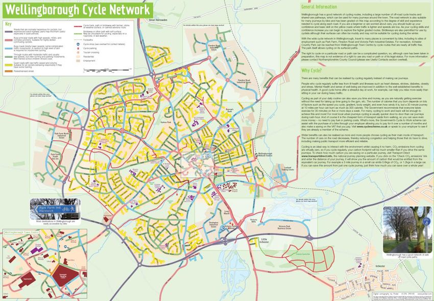
The Wellingborough Cycling Map was produced in 2011 and grades routes according to the degree
of skill and experience (see Figure 5).
Figure 5: Wellingborough cycle map
Parking
Currently all the parking within the town centre is free, with a mixture of on-street and off-street
parking available.
Off street
There are five Borough Council owned car parks within the town centre; the largest is Swansgate
multi-storey car park which forms part of the Swansgate shopping centre. Figure 6 overleaf
outlines the location of the public and private car parks in Wellingborough.
27Wellingborough Town Transport Strategy
Thomas Street
111 spaces
High Street Aldi and Matalan
524 spaces 200 spaces across both
car parks
Swansgate
multi-storey
952 spaces
Public car park Sharman Road
(Morrisons)
Private car park 545 spaces The Castle
135 spaces
© Crown copyright and database rights 2014 Ordnance Survey 100019331
Figure 6: Public and private car parks in Wellingborough town centre
Table 4 outlines the number of car parking spaces available within the town centre and their
ownership. Pending redevelopment, some temporary spaces have been created on the High Street
car park.
28Wellingborough Town
Wellingborough Town Transport Strategy
Car Park Owner Walking Type Charge No of
distance to spaces
Market
Square
High Street BCW 600m Long stay None 524
(including Leighton
Yard)
Sharman Road BCW* 300m Short stay None 545
(max 3 hours)
Swansgate multi- BCW 250m Long stay None 952
storey
The Castle BCW 600m Long stay None 135
Thomas Street** BCW 600m Long stay None 111
Aldi Private 350m Short stay Up to 1 hr free, 1- 200
2hrs a charge is
made
Matalan Private 350m Short stay Yes but redeemable
against £5 spend
Tithe Barn BCW 300m Long stay None 20
Railway station Network - Long stay Yes 531
Rail
*Managed by Morrisons **Sports centre
Table 4: Existing car parks in Wellingborough Town Centre
On-street
As well as the spaces outlined below, there are also in the region of 790 on-street parking spaces
within a five minute walk of the town centre.
Following ongoing issues regarding parking on residential streets near to the railway station, a
residents parking scheme operates on Chace Road, Colwell Road, Chester Road, Dryden Road,
Senwick Road, and parts of Midland Road, Talbot Road and Elsden Road. Permits have to be
displayed 9am-12noon Monday to Friday and the scheme has been positively received.
29Wellingborough Town Transport Strategy
Parking demand
In November 2008, a survey was undertaken in the town centre to establish the demand for car
parking. The survey found that at that time, the overall parking occupancy in the existing car parks
was approximately 75 percent. The highest demand was recorded in the Sharman Road
(Morrisons) car park both during the week and on a Saturday, and the figures showed an
increased pressure on the car parks on Saturdays.
These surveys were repeated in March 2014 at the same peak times that were identified as part of
the November 2008 surveys. The results are shown below in Table 5. Since the surveys in
November 2008, 93 additional spaces have been built at High Street which explains the decrease
in occupancy. In all cases apart from at Thomas Street, occupancy rates were lower in March 2014
than in November 2008. Some of this can probably be explained by the November 2008 figures
being influenced by Christmas shopping.
% Full (Mon-Fri)
Car Park Approx Peak November March 2014
Time 2008
High Street 10.30-11.30 85 65
Sharman Road (Morrisons) 10.30-11.30 96 79
Swansgate Multi-Storey 11.00-14.00 66 53
Thomas Street 15.30-17.30 85 99
The Castle 15.00- 19.00 85 78
Aldi/Matalan 11.30-14.00 62 22
Table 5: Occupancy rates for all surveyed car parks
Table 6 below outlines the parking durations recorded for all the public car parks in the town
centre from the November 2008 surveys. The figures show that the majority of people park for
less than 3 hours, but that there are around 14 percent of people who park for longer during the
week, most likely to be people who work in the town centre.
30Wellingborough Town
Wellingborough Town Transport Strategy
Duration Weekday % Saturday %
3 hours 1049 14 726 8
Total 7663 100 9025 100
Table 6: Duration of stay of parked vehicles for all public car parks
The main characteristics of parking provision in Wellingborough are as follows:
Large supply of long-stay parking with short stay parking reserved to Aldi/ Matalan;
Long stay car parking makes up 14 percent during the weekdays and 8 percent at the
weekend;
The majority of parking acts are for short stay and mostly less than 1 hour; and
The Swansgate multi-storey is under-utilised
Common themes
The key transport related challenges that emerge from the existing situation is:
The narrow road layout and one-way system contributes towards congestion in the town
centre which may become more pronounced as travel demand increases without some
level of capacity enhancements;
The bus network operates commercially Monday to Saturday during the day but evening
and Sunday services are not commercially viable and patronage levels are relatively low;
The walking and cycling network is well developed but further enhancements are needed
in the east and to address permeability into the town centre; and
Car parking is plentiful and free, the Swansgate multi-storey car park is currently
underutilised.
31Wellingborough Town Transport Strategy
Chapter 4: Future Growth
“Wellingborough will be the gateway to North Northamptonshire for businesses looking for good
rail connections to the south east and Europe, with a high profile office development centred on
the railway station. Its historic core will be the heart of the community, serving the town and its
prosperous satellite villages with a diversified retail, leisure and heritage offer.”
Emerging Joint Core Strategy 2011-2031
Strategic growth for Wellingborough
The Emerging Joint Core Strategy 2011-20313 outlines a housing requirement of 7,000 dwellings
2011 to 2031 for the borough of Wellingborough. To support the housing growth and create a self-
sustainable environment an accompanying minimum jobs target of 6,100 (2011-2031) has been
set.
The committed strategic sites or broad development locations in Wellingborough established in
the adopted Core Spatial Strategy are:
Wellingborough East (mixed use SUE)
Wellingborough North (mixed use SUE)
Park Farm/ Shelley Road (residential)
North West Wellingborough (employment)
The ‘new’ strategic sites or broad locations in the Emerging Joint Core Strategy are:
Appleby Lodge (employment)
The remainder of the housing growth is allocations of small to medium infill sites. A simplified
housing trajectory to 2021 is outlined below in Table 7. Sites under 250 dwellings are grouped
together. There is currently no published trajectory to 2031.
3
North Northamptonshire Joint Core Strategy – Emerging Plan for Consultation August 2012
32Wellingborough Town
Wellingborough Town Transport Strategy
Development site Housing trajectory
2013-21
Wellingborough East 1,300
Wellingborough North 800
Eastfield Urban Quarter 297
Park Farm Way 440
Town Centre Area Action Plan allocated sites 294
Sub total 3,131
Sites under 250 dwellings 1,530
Total 4,661
Table 7: Housing trajectory to 2021 in the Borough Council of Wellingborough (Source: AMR
2012/13 available on BCW website)
Figure 7 illustrates the location of the main development sites in Wellingborough.
Figure 7: Wellingborough – major areas of growth
33Wellingborough Town Transport Strategy
Town centre growth
The Borough Council of Wellingborough is currently reviewing the Town Centre Area Action Plan
(TCAAP) adopted in 2009 as part of producing the Plan for the Borough of Wellingborough and is
due to consult on an issues and options paper in 2014. The County Council will work closely with
Borough Council of Wellingborough to identify the infrastructure required to support the revised
aspirations and growth identified for the town centre as part of the development of the Plan for
the Borough of Wellingborough.
Schemes that have already been implemented that were identified in the TCAAP are bus priority
measures implemented at Sheep Street/Silver Street and Gloucester Place/ Market Street and a
new access road to the High Street development.
Increased demand for travel
Wellingborough’s ambitions for growth will clearly result in an increased demand for travel. To
understand the impact of this increased travel demand within the county as a whole and the main
towns such as Wellingborough, an area-wide transport model, the Northamptonshire Strategic
Transport Model (NSTM) has been developed to test the growth proposals in North
Northamptonshire for the Emerging Joint Core Strategy.
The first stage of developing a transport model is to replicate the traffic flows on the highway
network for the existing or ‘baseline’ situation. Once a model replicates the observed traffic in the
existing situation through a series of refinements known as ‘calibration’ the model can be said to
be ‘validated’. This ensures that every transport model is robust, and meets the standards as set
out by the Department for Transport (DfT) in the Design Manual for Roads and Bridges (DMRB).
To support the work of the Emerging Joint Core Strategy, a number of growth scenarios have been
modelled; in line with the minimum housing requirement and the strategic opportunity which is
based on all the Sustainable Urban Extensions coming forward by 2031 and is around 40,500
dwellings to 2031.
The outputs of the strategic opportunity scenario represents the most robust method of outlining
the junction and link capacity improvements that will be required as this represents the highest
level of housing and employment growth and therefore this is what the improvements in this
strategy are based upon. Transport modelling is an iterative process and further runs will be
34Wellingborough Town Transport Strategy
Wellingborough Town
undertaken to support the development of the Emerging Joint Core Strategy. It will also reflect the
Rushden Lakes development, approved by the Secretary of State and take into account the
relative growth in travel demand between Rushden and Wellingborough as a result. The outputs
from further transport modelling will be fed into subsequent updates of this strategy as
appropriate.
The Northamptonshire Strategic Transport Model (NSTM) is a multi-modal strategic transport
model as it replicates a range of transport modes; private and public transport as well as modal
interchange behaviour such as walking.
The NSTM covers all of Northamptonshire to take account of the key functional relationships in
the county; a key advantage of having one transport model as opposed to two separate transport
models as was the case previously.
The NSTM consists of two models; the base year, replicating the observed traffic conditions on the
existing highway network in the AM and PM peak (2008) and the future year model (2031). As the
work develops intermediate years of 2021 and 2026 will also be produced for phasing testing
purposes.
Figures 8 and 9 below outline the junctions that without mitigation will become congested in 2031
compared to the base year.
More detailed discussion of the junction testing undertaken in the model and impacts on the
highway is discussed in Chapter 5.
35Wellingborough Town Transport Strategy
Figure 8: Strategic Opportunity vs. Base Year volume over capacity AM peak
Figure 9: Strategic Opportunity vs. Base Year volume over capacity PM peak
36Wellingborough Town
Wellingborough Town Transport Strategy
Chapter 5: The Transport Strategy for Wellingborough
The challenge for the Wellingborough Town Transport Strategy is to efficiently manage the
transport network to accommodate the forecast housing and employment growth to retain
Wellingborough’s economic attractiveness and competitiveness.
This challenge will be met through:
Reducing the overall need to travel;
Improving the management of existing transport infrastructure; and
Investing in key transport infrastructure
In order to achieve this, the transport strategy for Wellingborough outlines a package of
sustainable transport measures to give people greater choice, as well as the highway capacity
improvements required.
Promoting the use of sustainable transport has historically been challenging due to the relatively
inexpensive cost of running a car and the time savings and flexibility that it offers. However,
certain elements have now come together to initiate the step change in people’s attitude towards
sustainable modes namely; environmental concerns, promotion of healthier lifestyles and as
congestion increases, the reduction in journey time difference between the car and sustainable
modes for short trips.
Highway network strategy
Wellingborough’s future highway network will support the town’s development, regeneration and
economic competitiveness whilst providing an environment that seeks to encourage sustainable
transport modes for shorter, internalised trips.
The focus of the highway strategy for Wellingborough has been determined by interrogation of
the Northamptonshire Strategic Transport Model and the review of outputs to identify where will
impact on the existing network to 2031.
The capacity improvements and schemes presented have been identified to address the residual
traffic, that is, the traffic that cannot be accommodated through the sustainable measures
outlined in the remainder of the strategy.
37Wellingborough Town Transport Strategy
Forecast network impacts
Three outputs from the NSTM have been used as indicators of where the existing network will
experience greatest link and junction stress in 2031 they are:
Traffic flows;
Queued delay; and
Volume Over Capacity (VOC)
The forecast change in traffic flows indicate the variation in demand for travel across the future
network compared to the base year and assists in highlighting where links are experiencing stress.
The forecast outputs can be used in conjunction with select link analysis to interrogate the model
further to understand trip origin and destination – particularly useful for understanding travel
patterns and travel demand.
Queued delay has been used to indicate where traffic is queuing which indicates likely areas of
congestion and delay.
Every junction has its own capacity figure which is dependant on the type of junction it is and its
geometry. The volume over capacity figure is a calculation of the degree to which the volume
(traffic flow) for the junction is exceeding its theoretical capacity and is expressed as a percentage.
Any junction with a V/C in excess of 85 percent is considered to be over its theoretical capacity.
Outputs of transport modelling
The transport modelling indicates that capacity upgrades will be needed at, but not limited to, the
following junctions:
1) The junction of Midland Road/Senwick Road and Elsden Road
2) The junction of Doddington Road and Turnells Mill Lane
3) The junction of the A45 with Bourton Way and the A4500
4) The junction of the A45/A4500 and the A509 (Northampton Road/ Wilby Way)
5) The junction of the A509/ Niort Way/ Harrowden Road
6) The junction of London Road/Turnells Mill Lane
The infrastructure required to accommodate the economic and planning aspirations in the town
centre will be developed in line with the timescales of the Plan for the Borough of Wellingborough
and so are not included within the strategy.
38Wellingborough Town
Wellingborough Town Transport Strategy
The junctions are annotated in the map below (Figure 10).
5
1
3 6
2
4
Figure 10: Wellingborough junctions under stress (excluding those in the town centre)
Corridor and junction improvements
The engineering solutions at each of these junctions are described below. The mitigation measures
are based on identifying which arms of the junction fails and what is required to accommodate the
increase in flows.
These capacity enhancements will not negate the need for all developments to demonstrate their
impact on the local highway network through a transport statement or transport assessment and
if appropriate, mitigate its impact in the near vicinity.
39Wellingborough Town Transport Strategy
Edge of town centre improvements
Wellingborough East and associated infrastructure
Once Wellingborough East comes forward, there will be a significant increase in traffic flows on
the roads in the vicinity of the railway station as this will be the main access route towards the
town centre.
Route 4 (see Figure 11) will comprise a new bridge over the railway to the north of the railway
station and associated works to upgrade and realign the route alongside the railway station
including the Midland Road/Senwick Road/Elsden Road junction. Transport assessments for
Wellingborough East and Eastfield Urban Quarter have established that the junction will require
capacity enhancements, which will also bring safety benefits at this location. The enhancements
will be delivered in a two-stage process: an interim signalisation solution provided by Eastfield
Urban Quarter and a long-term (double mini roundabout) solution.
Route 4
Figure 11: Route 4 Wellingborough East
40Wellingborough Town
Wellingborough Town Transport Strategy
The Turnells Mill Lane/London Road junction (together with the Embankment) will become one of
the main routes to Wellingborough East and as such Wellingborough East is also required to
improve it as part of the planning condition. Any scheme here needs to be sensitive to its setting
close to the avenue of mature trees on London Road, and should also form a gateway feature into
Wellingborough. A scheme has been identified within the highway boundary which comprises
signalising the roundabout to optimise capacity and improve pedestrian movements alongside
signing and lining of the roundabout to improve lane discipline.
Previously a North-South Link to the west of the railway was highlighted to be provided to as part
of the WEAST infrastructure. Subsequent feasibility work that has been carried out has identified
that the proposed alignment would cost in the region of £35-53m (excluding land costs and VAT)
due to the major civil engineering works that would be required and the Land Compensation Act
claims from residents.
Furthermore, testing in the Northamptonshire Strategic Transport Model has identified that there
are minimal journey time and congestion benefits and that traffic flows can be adequately
accommodated without this piece of infrastructure and therefore this scheme is not currently
being pursued any further.
Doddington Road/ Turnells Mill Lane
The Doddington Road/ Turnells Mill Lane junction shows considerable stress in 2026. By signalising
it, capacity would be increased.
Northampton Road/ Wilby Way
This junction will come under additional stress as a result of development to the North of
Wellingborough accessing the A45 and as more traffic re-assigns to the A4500 to avoid the A45
(impacting particularly on the A4500 arm) and the development of Appleby Lodge. A four arm
signaled roundabout necessary to mitigate the traffic flows from the Appleby Lodge Planning
Application has been identified which meets projected traffic growth to 2031.
Westfield Road/Hardwick Road
Although Westfield Road/ Hardwick Road has not been identified through the transport modelling
work undertaken so far, local residents have raised the issue of traffic patterns in this area,
41You can also read