Draft Te Tairāwhiti Regional Land Transport Plan 2021-2031 Te Mahere Waka Whenua o Te Tairāwhiti 2021-2031
←
→
Page content transcription
If your browser does not render page correctly, please read the page content below
Draft Te Tairāwhiti Regional
Land Transport Plan
2021-2031
Te Mahere Waka Whenua
o Te Tairāwhiti 2021-2031
Our transport network, the challenges we face, and
our priorities for future investment
Tō tātau tūhononga waka whenua, ngā tauwhāinga
me ngā whakaarotau matua kei mua hei whakahaumi
Contents
Executive Summary ............................................................................................................................................... 4

Introduction ............................................................................................................................................................. 5

Our region................................................................................................................................................................ 6

       Our People ...................................................................................................................................................... 7

       Our Land .......................................................................................................................................................... 7

Our transport system.............................................................................................................................................. 9

       Roads ............................................................................................................................................................... 9

       Active transport............................................................................................................................................ 10

       Public transport services ............................................................................................................................. 11

       Rail .................................................................................................................................................................. 11

       Sea .................................................................................................................................................................. 11

       Air .................................................................................................................................................................... 12

Policy context ....................................................................................................................................................... 13

       Core statutes ................................................................................................................................................ 13

       Other national policy context ................................................................................................................... 13

       Regional policy context ............................................................................................................................. 15

Drivers for change ................................................................................................................................................ 17

       COVID-19 Impact and recovery .............................................................................................................. 17

       Financial constraints .................................................................................................................................... 17

       Climate change........................................................................................................................................... 18

       Demographic changes .............................................................................................................................. 19

       Freight demands .......................................................................................................................................... 20

Strategic Framework ........................................................................................................................................... 22

Te Tairāwhiti Transport Investment Priorities .................................................................................................... 24

Transport priority 1: Safety .................................................................................................................................. 25

Transport priority 2: Reliability and Resilience ................................................................................................ 29

Transport priority 3: Access Challenges .......................................................................................................... 33

Proposed Regional Land Transport Activities.................................................................................................. 38

                                                                                                                                                                              2
Committed activities ................................................................................................................................... 38

       All proposed activities................................................................................................................................. 40

       Regionally significant activities ................................................................................................................. 49

       Inter-regionally significant activities ......................................................................................................... 51

       Ten year summary ....................................................................................................................................... 53

Appendix 1: Monitoring Framework ................................................................................................................. 55

Appendix 2: Evidence and maps ..................................................................................................................... 60

       Safety ............................................................................................................................................................. 60

       Reliability and Resilience ............................................................................................................................ 63

       Access challenges ...................................................................................................................................... 64

Appendix 3: Significance policies .................................................................................................................... 69

       Significant activities for regional prioritisation ........................................................................................ 69

       Significant variations to the RLTP............................................................................................................... 70

Appendix 4: Assessment of RLTP compliance with the LTMA ...................................................................... 72

Appendix 5: Glossary .......................................................................................................................................... 74

                                                                                                                                                                          3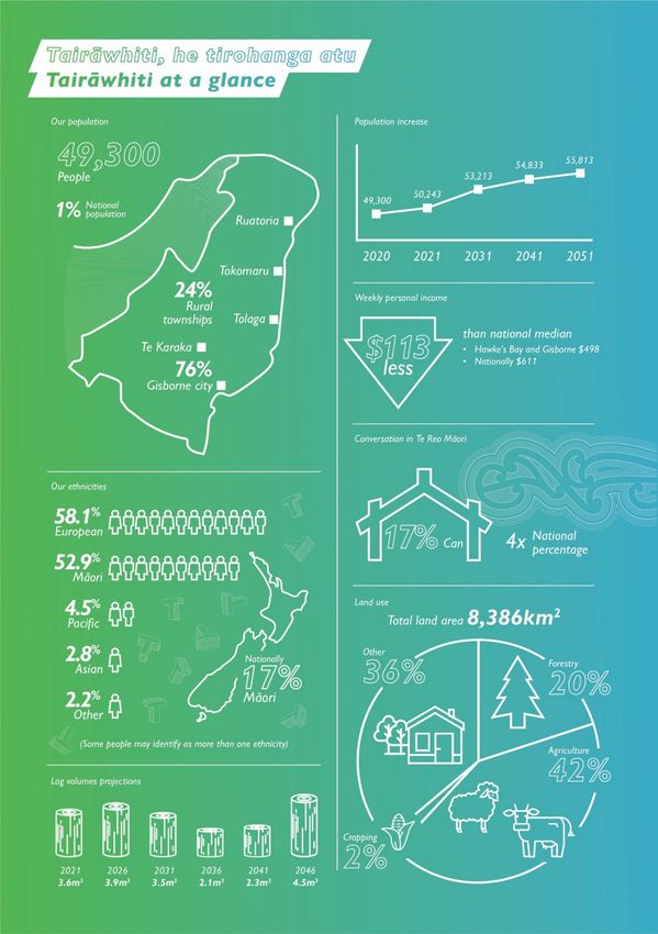
Executive Summary

 Whakarāpopoto Matua
Te Tairāwhiti Regional Land Transport Plan (RLTP) sets out the current state of our transport network,
the challenges we face, and the priorities for future investment.

As one of the country’s most remote regions, our land transport system is essential for connecting us
to the rest of the country and to each other. Our vision for this plan, is that our communities and
businesses are connected to each other and to our markets by a safe, sustainable and resilient
transport network.

Te Tairāwhiti’s unique geography, geology and social and economic environment presents many
challenges to providing and maintaining the large land transport network for our region. Predicted
changes to climate, demographics and freight volumes will also impact how we manage our roads
and the levels of service they have to provide.

The three priority investment areas we have identified for this RLTP to help us achieve our vision are:

   •   Safety - Investment in safety infrastructure interventions for high risk areas, speed
       management and safety promotion programmes targeted at reducing deaths and serious
       injuries.
   •   Reliability and resilience - Target investment in projects that enable growth and improve
       travel time reliability and resilience
   •   Access - Planning and investment in programmes and infrastructure targeted at providing
       and promoting transport choice

This draft plan has been developed in partnership with Waka Kotahi New Zealand Transport
Agency (Waka Kotahi) and the Regional Transport Committee (RTC).

In developing the draft RLTP, we have been guided by the strategic direction provided through the
Ministry of Transport’s Transport Outcomes Framework and the Government Policy Statement of
Land Transport 2021, Waka Kotahi guidance and our regional plans and strategies.

                                                                                                     4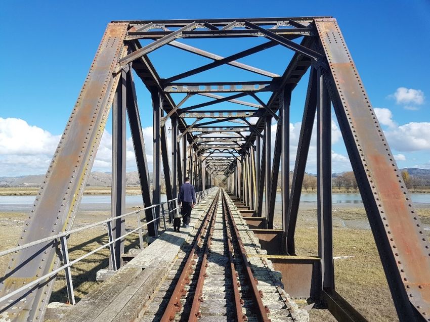
Introduction

 He Whakatakinga
Te Tairāwhiti Regional Land Transport Plan (RLTP) sets out the current state of our transport network,
the challenges we face, and the priorities for future investment. The plan sets out:

   •     the context in which the transport system operates
   •     the vision and strategic objectives for the transport system
   •     the priorities for investment – key areas where further investment is required in order to
         achieve the vision and objectives
   •     a prioritised regional programme of transport activities.

This RLTP was developed by Gisborne Regional Transport Committee (RTC). The RTC is a joint
committee of Gisborne District Council (Council) and Waka Kotahi New Zealand Transport Agency
(Waka Kotahi). Developing the RLTP is the primary role of the RTC and is a requirement under the
Land Transport Management Act 2003.

A number of statutes and policy documents provide the legislative and policy context for land
transport planning and investment at the national, regional and local level. Figure 1 illustrates the
strategic relationships between this plan and other relevant legislation, government policies and
plans.

Figure 1 Strategic policy framework for Regional Land Transport Plans

                                                                                                        5
Our region

Tō tātau rohe

                6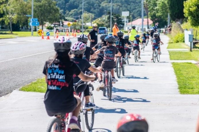
Our People
Ō tātau tāngata
Te Tairāwhiti (Gisborne region) is one of the country’s most remote regions and home to
approximately 49,300 people, 1% of New Zealand’s population 1. The region covers a land area of
8,350 square kilometres in the eastern corner of the North Island. This is approximately 3% of New
Zealand’s total land area.

The region is sparsely populated and relatively isolated, with long distances between settlements.
The majority of people (76%) live in Gisborne city1. The remainder of people live in rural coastal and
inland townships, connected by SH35, and SH2. Maintaining our roading network is essential for
connecting people to essential services and to each other.

There is a general trend that suggests populations are continuing to decrease across the rural
townships 2. Over time, population decrease has led to the closure of local businesses and the
vibrancy of the town centres of the rural townships diminishing.

However, each township has a distinct local identity with strong and passionate community
champions, rich cultural heritage values, landscape values and many tourist attractions. Almost
53% of people in Te Tairāwhiti identify as Māori, compared to 16.5% nationally.

The region has a high percentage of people under 15 (23.7% versus 19.6% nationally), and over 65
(15.5% versus 15.2%) 3 compared to national age distribution. Providing infrastructure appropriate for
an ageing population and having the ratepayer base to pay for it will be an ongoing issue for our
region.

Our Land
Te Whenua
Te Tairāwhiti has a hilly to mountainous interior, with fertile low-lying river plains and coastal flats. Its
geographical location, topography and geology, with the hill country prone to erosion and
subsidence, creates a challenging environment for providing affordable infrastructure.

The region has varied land types with 71% of the region classified as steep hill country. Our gentle
rolling land is very fertile - the Poverty Bay Flats is the single largest area of high-quality fertile soils in
New Zealand 4.

Agriculture has been the most important industry in the Te Tairāwhiti region since earliest settlement.
However, agriculture has diversified over the years and now forestry, viticulture, horticulture and
industries such as food processing are becoming increasingly important.

Of the 835,000 hectares of land in the region, 42% is used for pastoral farming. Exotic forest covers
around 20% of the district. Much of the forestry was planted as part of erosion protection schemes
after Cyclone Bola in 1988. Many of these forests are now being harvested. Responding to the
growth in forestry continues to be a challenge for our roading network.

1   Statistics New Zealand, 2019, cited in Thomas Consulting. (2020). Gisborne District Council Growth Forecasts.
2   Thomas Consulting. (2020). Gisborne District Council Growth Forecasts.
3Statistics New Zealand. (n.d.) . Gisborne Region: Population and dwellings (2018 Census data). Retrieved from
https://www.stats.govt.nz/tools/2018-census-place-summaries/gisborne-district#population-and-dwellings
4   Gisborne District Council. (2020). Our Land and Soil: Tō Tātau Whenua, One Hoki. Gisborne: Gisborne District Council.

                                                                                                                            7
The Poverty Bay Flats provide the largest area in the region for horticulture and cropping. There has
been a 110% increase in irrigated high-value crops such as apples, kiwifruit and persimmons
planted on the Poverty Bay Flats over the last ten years 5.

Te Tairāwhiti is subject to a wide range of natural hazards that can threaten the security and
resilience of our roading network. The roading network is particularly susceptible to weather events.
Periodic remnants of decaying tropical cyclones and storms can cause high rainfall, winds and
high seas. These events can result in flooding, coastal flooding by the sea, coastal erosion and
landslides.

5   Gisborne District Council. (2020). Our Land and Soil: Tō Tātau Whenua, One Hoki. Gisborne: Gisborne District Council.

                                                                                                                            8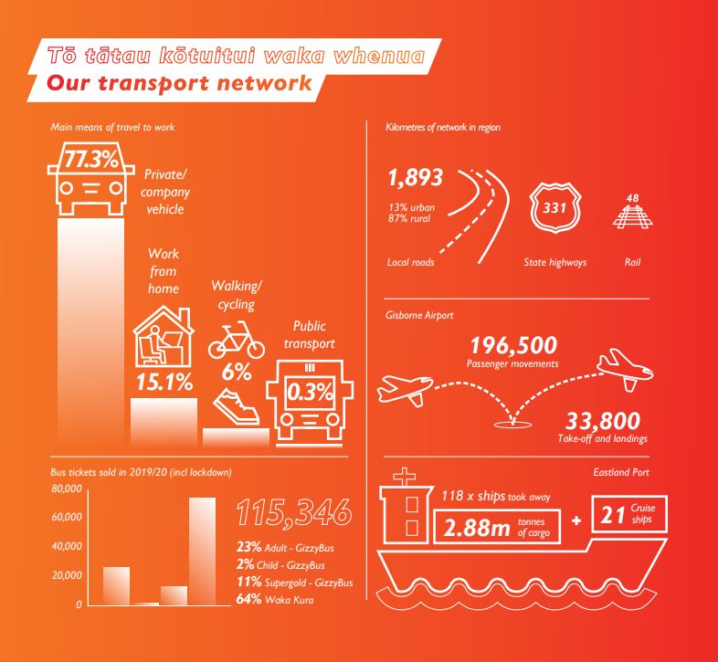
Our transport system

    Tō tātau pūnaha waka whenua

Roads
Ngā Rori
Gisborne city and Tairāwhiti as a region are both relatively isolated from the rest of the North Island.
We rely heavily on two state highway corridors to connect within the region as well as to
neighbouring regions and the rest of the country. SH2 provides the only viable road connection to
the south, while SH2 and SH35 connect Te Tairāwhiti to the Bay of Plenty. Almost half of kilometres
travelled in the region are on state highways 6.

6   Waka Kotahi. (2020). Arataki Version 2-Gisborne Regional Summary 2021-2031. Wellington: Waka Kotahi.

                                                                                                           9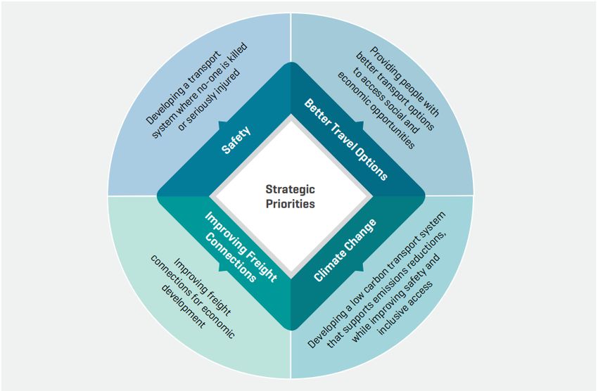
Council is responsible for 85% (1,893km) of the region’s total roading network, of which 13% of the
Council’s network is urban and 87% is rural, with 46% sealed and 54% unsealed. Our primary
industries are heavily reliant on land transport for the majority of produce and supply movement.

Council receives a subsidy from Waka Kotahi through the National Land Transport Fund (NLTF) to
enable ratepayers to afford the provision and maintenance of our local road network. The Funding
Assistance Rate (FAR) is currently 68% for Te Tairāwhiti but will reduce to 66% by 2021. This means
that for every dollar we spend on an approved activity on our local roads, the NLTF contributes 68
cents and Council contributes 32 cents. Most of Council’s local share comes from ratepayers. Some
projects will also require external funding or grants to complete.

Travel in Te Tairāwhiti is dominated by private vehicle trips with over 90% of work trips undertaken by
private vehicle in 2018. Although, a higher percentage of residents work from home (15.1%) than
the rest of New Zealand (11.9%) 7.

The key areas of growing pressure on the transport network include rapid growth in freight,
particularly export log volumes to the port and other sites, and growing traffic volumes on key
urban routes.

Active transport
Waka haere
Journey to work statistics indicate that the
number of trips undertaken using active
modes are declining (11.7% 2001 to 7.1%
2018).

Council and Waka Kotahi have continued to
expand the urban walking and cycling
network including the clip-on separated path
over the Gladstone Road Bridge.
Construction is also under way to link the
Wainui to Kaiti cycleway to the Inner
Harbour via Crawford Road.                 Figure 2: Wainui to Kaiti cycleway opening

Council has committed to prioritising its cycleway programme for commuters, especially where it
creates safe access for school children. Improving our cycle links and creating safe cycling routes
are key priorities in developing our cycle network. This is particularly important for Kaiti secondary
school students, who must travel across the city to where all four secondary schools are clustered.

See Figure 12 Urban walking and cycleway current and proposed future network, page 65.

7Statistics New Zealand. (n.d.) . Gisborne Region: Transport (2018 Census data). Retrieved from
https://www.stats.govt.nz/tools/2018-census-place-summaries/gisborne-district#transport

                                                                                                     10
Public transport services
Ngā ratonga waka tūmatanui
Te Tairāwhiti has a limited number of public transport services, targeting accessibility rather than
journeys to work. Gisborne city has two urban bus routes (GizzyBus) operating from the city centre
on Bright Street and nine school bus services (Waka Kura).
Together with the Total Mobility Scheme for people with disabilities, these services are provided
under contract and are subsidised by Waka Kotahi and Council. There are no public transport
services linking our regional townships, which rely on private vehicles or volunteer services.
Our Regional Public Transport Plan 2021-2027 provides more information on our current public
transport services and our plans for public transport over the next three years.
Rail
Rerewhenua
The Gisborne to Napier portion of the
Palmerston North-Gisborne Line
(PNGL), a secondary main line, was
completed in 1942 and primarily
operated a freight movement
function. However, the line was closed
in 2012 following several large
washouts north of Wairoa, resulting in
significant damage to rail
infrastructure.
In early 2018, KiwiRail reopened the
section of line between Wairoa and
Napier with support from the Regional
Infrastructure Growth fund. The Wairoa
to Gisborne section of the track has Figure 3: Waipaoa River rail bridge
recently been leased for tourism
activities. The section between Gisborne and Muriwai is used for steam train excursions.
The BERL report Tūranga ki Wairoa Rail – feasibility study into the reinstatement of rail line, was
released in December 2019. The report concluded that from an engineering perspective, it is
feasible to reinstate the rail line to a level that would be more resilient to damaging weather
events.
While reinstatement of the Gisborne to Wairoa rail line was not included in the New Zealand Rail
Plan 2021-24, we will continue to advocate for the project’s inclusion in later years.
Sea
Waka Moana
Forestry is a major driver for freight movements from harvest areas across the region to Eastland
Port. Because of the significant increases in logging volumes to the port and the effects of heavy
11vehicles on the roading network, there has been interest in exploring other freight modes. This
includes expanding capacity for the existing Eastland Port.
Eastland Port exported 2,890,730 tonnes of cargo during the 2019/20 financial year, equating to
over 100,000 full truck movements. With projected growing volumes of logs, kiwifruit and apples
from the region the port’s current role as a regional bulk export port is likely to change in coming
years to support growing container export volume via coastal shipping to both Napier and
Tauranga.
Eastland Port is currently undertaking their ‘Twin Berth’ development which involves repair and
maintenance of ageing port structures, more space to store logs and other cargo, stronger
wharves to handle logs, and space to park two 200m long ships at the port at the same time.
Air
Waka Rererangi
Te Tairāwhiti is relatively isolated from other population hubs and efficient air travel is vital to our
local economy. Reliable air connections provide businesses with opportunities to expand and
grow, residents with vital links to whanau and friends, and bring more visitors to the region.
Gisborne Airport is a regional airport located 4.2 km from the city centre. It includes a sealed and
night-capable runway, as well as three grass runways suitable for light aircraft. The airport is owned
by Council and operated by the Eastland Group by lease agreement.
A $12.5 million airport redevelopment project was completed in November 2020. Year on year
growth and increasing passenger numbers confirmed the need for a new airport terminal. Now,
strong air transport links to the rest of New Zealand are more essential than ever, to support the
region’s recovery after COVID-19 and promote ongoing economic development.
The redevelopment was co-funded by the Provincial Growth Fund, Eastland Group Ltd and the
Eastland Community Trust 8.
There are also regional air strips at Ruatoria and Te Araroa which are currently undergoing
development. Funding from the Provincial Growth Fund's Whenua Maori allocation has been
granted for an aerodrome at Ruatoria. The aerodrome in Te Araroa will be a joint venture between
Te Rimu Trust and Eastland Group.
The regional airstrip developments will improve access for medical flights and during civil defence
emergencies, when roads may be blocked, in addition to providing tourism and business activities.
8 Now named Trust Tairāwhiti
12Policy context
Horopaki Kaupapa
Core statutes
Ngā ture matua
Land Transport Management Act (LTMA) 2003 - the principle statute guiding land transport
planning and funding in New Zealand. The purpose of the Act is to contribute to achieving an
affordable, integrated, safe, responsive and sustainable land transport system. The LTMA sets out
the core requirements of regional land transport plans and regional public transport plans for every
region.
In order to recognise and respect the Crown’s responsibility to take appropriate account of the
principles of the Treaty of Waitangi, the LTMA also provides principles and requirements that are
intended to facilitate participation by Māori in land transport decision-making processes.
An assessment of RLTP compliance with the LTMA, including an outline of the engagement
undertaken, is provided in Appendix 4, page Error! Bookmark not defined..
Resource Management Act (RMA) 1991 which aims to promote the sustainable management
of natural and physical resources and provides the statutory framework for land use
planning and the development of regional policy statements, regional plans and district plans.
Land use planning can have a significant influence on travel choice and transport network
demand. The Gisborne Regional Transport Committee must take the Regional Policy Statement
(included in the Tairāwhiti Resource Management Plan) into account when developing the RLTP.
Local Government Act (LGA) 2002 guides local government planning and the
way councils carry out their functions. It includes provisions guiding the development of council
long-term plans and infrastructure strategies, where the local funding share for transport network
investment is identified alongside other local investment priorities. The LGA also sets out consultation
principles that are relevant for development of regional land transport plans.
Climate Change Response Act 2002, which was amended by the Climate Change Response
(Zero Carbon) Amendment Bill in 2019. Key provisions include setting a target to reduce net carbon
emissions to zero by 2050. The transport sector will have a key role in contributing to achieving this
target and the direction set at a national level has informed the development of this RLTP.
Other national policy context
Ētahi atu horopaki kaupapa ā-motu
Transport Outcomes Framework
This framework takes a strategic, long-term, and integrated approach to transport and makes clear
what government is aiming to achieve through the transport system in the long term. The five
outcomes are:
13The RLTP has integrated these outcomes as the foundation of its strategic framework, to align with
this enduring long term direction.
Government Policy Statement on Land Transport
The LTMA requires the Minister of Transport to issue the Government Policy Statement on Land
Transport (GPS) every three years. The GPS sets out the government’s priorities for expenditure from
the National Land Transport Fund over a 10-year period, and how funding should be
allocated. RLTPs must be consistent with the GPS, and Waka Kotahi must give effect to it with
regards to land transport planning and funding.
The current GPS strategic priorities are:
14The RLTP has taken account of the current GPS direction and priorities, particularly in relation to the
identification of its short – medium term transport investment priorities and regional programme.
Road to Zero – NZ Road Safety Strategy 2020 - 2030
Road to Zero articulates government’s vision of ‘a New Zealand where no one is killed or seriously
injured in road crashes’. It sets out the five areas of focus for the next decade: infrastructure
improvements and speed management; vehicle safety; work-related road safety; road user
choices; and, system management.
This RLTP includes a headline target that is aligned with the Road to Zero target of a 40 percent
reduction in deaths and serious injuries by 2030 at a regional level.
New Zealand Energy Efficiency and Conservation Strategy (NZEECS) 2017-2022
Sets the overarching direction for government and specific actions for the promotion of energy
efficiency and renewable sources of energy. The contribution of public transport (fleet and use)
and efficient freight movement are recognised in the strategy and this has been taken into
account in developing the policies and priorities in the RLTP as required by LTMA.
Arataki
Arataki is Waka Kotahi’s 10-year view of what is needed to deliver on the government’s current
priorities and long-term objectives for the land transport system. Arataki outlines the context for
change and the levers Waka Kotahi will use, in partnership with others, to shape change. It includes
national, pan-regional and regional summaries. The key regional step changes identified for Te
Tairāwhiti are Support Regional Development (medium priority) and Tackle Climate Change
(medium priority).
Other national plans which provide important context for this RLTP include:
• the Waka Kotahi’s National Mode Shift Plan - sets out national objectives and programmes
to increase the share of travel by public transport, walking and cycling by shaping urban
form, making shared and active modes more attractive, and influencing travel demand and
transport choice.
• the Ministry of Transport’s New Zealand Rail Plan - outlines the Government’s long-term
vision and priorities for New Zealand’s national rail network, both freight and passenger
networks.
Regional policy context
Ngā horopaki kaupapa ā-rohe
Gisborne Regional Public Transport Plan (RPTP)
A Regional Public Transport Plan is required under the LTMA and provides a mechanism for
planning and engaging on the design and operation of the public transport network. The RPTP is
being reviewed in line with the RLTP and seeks to provide an efficient, accessible and financially
sustainable public transport network that supports the needs and wellbeing of our communities.
15Tairāwhiti Resource Management Plan
The Tairāwhiti Resource Management Plan covers all Gisborne District Council’s resource
management plans, including the regional policy statement, regional coastal plan, regional plan
and district plan.
Gisborne District Council 2021-2031 Long Term Plan (LTP)
The LTP outlines the activities and services Council is planning to provide over the next 10 years and
how we will pay for them. The LTP includes Council’s Financial Strategy and Infrastructure Strategy.
The amount of land transport funding available from rates is set through the LTP, prioritised
alongside all of Council’s activities.
Tairāwhiti 2050
Our spatial plan, Tairāwhiti 2050, was adopted in January 2020. It sets out the aspirations for our
region over the next 30 years including: Our communities and businesses are connected to each
other and to our markets by a safe, efficient and integrated transport network. Walking, cycling
and public transport are preferred choices.
16Drivers for change
Ngā kaiarataki panoni
COVID-19 Impact and recovery
Te Whakapānga me te whakaora mai COVID-19
Significant levels of uncertainty remain regarding the scale and duration of COVID-19 impacts,
particularly in the medium to long-term.
Although Te Tairāwhiti’s economy had been lagging behind the national average pre-COVID-19,
we may be better positioned than most to ride out the impacts of the pandemic because of the
scale of the primary production, healthcare and social assistance, manufacturing and education
sectors. These sectors are expected to recover in line with, or above, business as usual in the longer-
term 9.
Tairāwhiti Rau Tipu Rau Ora is our region’s COVID-19 Pandemic Response and Recovery Plan. The
purpose of Rau Tipu Rau Ora is to not simply restore the good things we had before COVID-19, but
to future proof, and re-establish an even better region with a whole-of-wellbeing approach.
The plan recognises the importance of transport in regional resilience and getting our economy
moving and includes the priority action: Invest in the airport, SH35 and local roads, and shipping
infrastructure to provide improved network optimisation and resilience for tourism and trade.
The $23.755m Tairāwhiti Economic Support Package Redeployment Programme was established to
help local workers affected by the impact of COVID-19. While initially aimed to assist displaced
forestry workers, the scope was broadened to include all affected.
The redeployment programme is funded through the Ministry of Business, Innovation and
Employment, administered by the Provincial Development Unit and managed by Gisborne District
Council. The mahi includes environmental work across the rohe and roading projects; the re-
metalling of unsealed roads throughout the region and the clearance of hazardous trees from local
routes.
It’s a huge collaborative effort among so many, including key agencies, iwi and business partners,
who are all very focussed on ensuring the 200-odd workers on the Programme gain new skills,
qualifications and exposure to the opportunity for meaningful, long-term employment.
Financial constraints
Ngā herenga ahumoni
It is expensive to build and maintain roads in Te Tairāwhiti due to our relative isolation and poor
quality subbase and surface materials.
9Waka Kotahi. (2020). Arataki Version 2-Gisborne Regional Summary 2021-2031. Retrieved from
https://www.nzta.govt.nz/assets/planning-and-investment/arataki/docs/regional-summary-gisborne-august-2020.pdf
17Council’s roading budgets in the past have been set by ratepayer affordability rather than the
actual cost of asset maintenance. Subsequently, the programme focus has been geared towards
reactive rather than preventative works which has reduced levels of customer service.
In order to maintain our existing network and respond to growth pressures, Council will need to
focus on increasing non-rate payer funding. This could be through grants/subsidies, partnerships
and external funding arrangements.
Central government funding through the Provincial Growth Fund (PGF) has allowed us to make up
for some recent funding shortfall. The PGF funding is targeted at regional economic development,
in regions with challenges in; high unemployment, lower productivity, skilled worker gaps, and
general economic struggles.
The Gisborne Integrated Transport Priority Plan was developed under the Tairāwhiti Economic
Action Plan and put forward a number of projects to assist regional development. A total of $64.2m
was approved for Council’s local roading programme. Works included the upgrade of Gisborne
city’s central business district, the Waimata Valley Road seal extension, the Rakaiatane Road
upgrade and the completion of more than $15m of resilience works across the rural network.
The PGF programme will end 30 June 2021, with only the 50max bridge upgrades and Local Road
Route Security projects continuing into the RLTP 2021-2031.
Climate change
Ngā rerekētanga āhuarangi
Climate change will impact how we plan and manage all our infrastructure activities. NIWA has
produced a climate change implications report for Te Tairāwhiti and Hawke’s Bay. The report
focusses on the impacts of both a high emissions (business as usual) and mid-range emissions
(stabilisation) pathway on the climate, river flows and key economic sectors.
Climate change trends expected for Te Tairāwhiti include:
• Warmer average temperatures (an increase of 0.5-1.0°C by 2040) and a greater number of
heatwave days when temperatures exceed 25°C for three or more consecutive days
• Generally, a small decrease in average rainfall across the district; but with local and
seasonal variations in the level of change projected
• Eastern Te Tairāwhiti is projected to experience some of the largest increases in Potential
Evapotranspiration Deficit (drought conditions measure) in the country by 2090
• Potential increase in storm intensity (wind extremes and rainfall)
• A sea level rise of 0.4m is projected to occur at either 2090 under the stabilisation pathway or
2060 under the business-as-usual pathway.
Many of these trends will exacerbate existing natural hazard threats.
Some areas of our transport system are at risk from sea level rise or will need upgrading to cope
with more extreme weather events. It is predicted that there will be an increase in areas that
require repairs or replacement following more intense storms. This will have ongoing cost
implications for both capital and operational expenditure, and, in some situations, the viability of
infrastructure may be threatened.
How we design, build and operate our infrastructure can support climate change mitigation and
adaptation. For example, some construction materials and methods have a larger carbon footprint
18that others, and where we locate new infrastructure can affect how vulnerable it is to climate
change impacts. One of our priorities is to invest in infrastructure that is able to adapt to change.
The NIWA report will form part of the evidence base for Council’s climate change response
including a regional climate change risk assessment, the Tairāwhiti Resource Management Plan
review and asset adaptation planning.
The first national climate change risk 10 assessment will inform the development of a national
adaptation plan, which will be released by August 2022.
Council in conjunction with Trust Tairāwhiti have completed a regional emissions profile and
together with other regional organisations are developing a regional emissions reduction plan.
Council has also completed its own emissions inventory in preparation for an emissions reduction
plan.
Demographic changes
Ngā rerekētanga ā-iwi
Te Tairāwhiti has experienced population growth since 2018, and the population is set to increase
by over 6,000 in the next 30 years 11.
Growth is not likely to be evenly spread across the region, with some rural areas likely to experience
further decline consistent with the trend of urbanisation. This may affect the viability of Council
services in rural areas, impacting on the wellbeing of those communities.
The most significant increase is in the over 65 age group and this is set to continue. An ageing
population has implications for transport provision including:
• Ongoing financial sustainability where the rating base is comprised of an increasing number of
retired ratepayers (including their ability to pay rates).
10 Released in August 2020. Available from https://www.mfe.govt.nz/climate-change/assessing-climate-change-risk
11Based on the medium growth forecast in: Thomas Consulting. (2020). Development Contributions Policy: Growth
Forecasts.
19• The types of services and infrastructure an ageing population will need (such as accessibility
and recreational needs), how this contrasts with the needs of other population groups, and
delivery options
The National Policy Statement for Urban Development 2020 requires the provision of sufficient
capacity in our infrastructure networks to meet the diverse demands of our communities over the
short, medium and long-term.
We need to make sure that people can get around the city and to schools, work and other
destinations safely and in a way that supports our commitment to climate change mitigation.
The region will need a well-integrated and well-designed land use and transport system to ensure
we are providing appropriate infrastructure to support growth and demographic changes.
Tairāwhiti 2050, our spatial plan, mapped out the aspirations for our region. The Tairāwhiti Resource
Management Plan review will carry these aspirations through to our resource management
planning.
Emerging technologies, such as on-demand public transport, could provide a feasible shared
transport option to improve access to services both in Gisborne city and more remote rural areas.
Freight demands
Ngā tonotono utanga
Forestry is the largest industry in Te Tairāwhiti and still growing. Eastland Port exports, predominantly
logs, have increased from around 1 million tonnes in 2010 to around 3 million in 2019 (Figure 2).
There has also been an associated increase in heavy vehicle traffic movements.
Figure 4 Exports from Eastland Port
A 2019 review estimates that the total harvest will average about 3.50 – 3.90 million cubic metres
per year between 2019 and 2028, providing infrastructure meets demands and there is a
20competitive market. A slight decrease is projected between until 2034-2043, before harvest
volumes rise to new record levels 12.
Maintenance costs per kilometre for the last 5 years on all road classifications have increased 15-
55% per kilometre. The increase in expenditure has not resulted in an increased or maintained
customer levels of service. Routes that have seen significant increases in traffic volumes continue to
deteriorate faster than they were designed to.
There has also been a 110% increase in high-value permanent crops such as modern apples,
kiwifruit and persimmons, over the last ten years. These “high-value” crops are displacing lower
value crops which do not require irrigation, such as grapes and older apple varieties. However,
irrigation is a major constraint to current levels of use, as well as future growth. Due to growth
constraints around horticulture crops, it is expected that the majority of freight increases will come
from forestry harvests.
Responding to the increasing freight load on our roads will be a key issue for our region. The main
focus will be on preventative asset management practices to ensure the overall network
sustainable within maintenance budgets. Bridge upgrades to increase the network’s 50max
capacity aims to reduce total truck numbers. Council is also proposing to introduce heavy freight
restrictions on parts of the urban network.
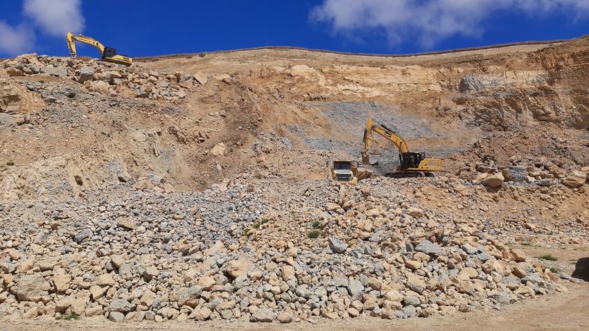
Figure 5: Waerenga-O-Kuri Quarry, Tiniroto Road
12 FORME (2019). Regional Log Availability Report.
21Strategic Framework
Te Anga Rautaki
The strategic framework for Te Tairāwhiti is underpinned by and aligned with the Ministry of
Transport’s Outcomes Framework
Ministry of Transport’s Outcomes Framework
The purpose of the transport system is to improve people’s wellbeing, and the liveability of places
Outcomes
Inclusive access Healthy and safe Environmental Resilience and Economic
people sustainability security prosperity
Regional Land Transport Plan – 30-year vision
Our communities and businesses are connected to each other and to our markets by a safe,
sustainable and resilient transport network
Strategic objectives Policies
Safety • Road safety interventions will follow the road to zero
approach
A transport system that is healthy
• Safe active travel will be encouraged and supported
and safe for all users, with no
through endorsement of a Walking and Cycling Plan
deaths or serious injuries.
• Heavy vehicle routes avoid conflicts with vulnerable
road users
Resilience • Viable route alternatives are available to avoid route
closures
A land transport network that is
• Identify and progressively address network resilience
resilient to changes in climate, land
concerns through network upgrades
use and demand
• Develop a risk-based approach to manage natural
hazards and climate change adaptation
• Ensure that new and existing transport infrastructure is
resilient to natural hazards and climate change through
location, design and construction.
Access • Key services in Gisborne city should be accessible by a
choice of transport modes
Everyone has access to transport to
• Opportunities to support mobile services to remote
get where they need to go
communities will be explored
• Continue planning and building walkway and
cycleway infrastructure for access to services
• Transport infrastructure will be progressively improved to
promote universal access
22• Gisborne city form will be compact and walkable,
supporting universal access in line with accessibility
guidance
Economic performance • Upgrade key freight routes to accommodate 50max
vehicles
A transport system that enables the
• Explore the potential for and support the development
efficient and reliable movement of
of rail and coastal shipping as alternatives to road
people and goods to, from and
freight
throughout the region
• Ensure cost and benefit links between primary industry
and road maintenance are clearly understood
Environmental outcomes • Opportunities to support active and public transport
modes will be explored
A transport system which supports
• Procurement processes shall encourage emission saving
low-carbon travel and communities
measures.
and has minimal impact on the
• Develop guidance to minimise environmental impacts
environment
of road construction and maintenance
• The Tairāwhiti Resource Management Plan supports
compact city development and active travel
• Travel to schools is supported through appropriate
infrastructure providing safe routes for active modes.
23Te Tairāwhiti Transport Investment Priorities
Ngā Take Matua Whakahaumi Waka Whenua o Tē
Tairāwhiti
Achieving the strategic objectives for the region requires consideration of the challenges to
achieving them. These have been summarised as three problems, along with the benefits
associated with solving the problems, and the strategic response necessary to achieve them.
The problem statements have been developed using the Investment Logic Mapping (ILM) process,
in alignment with Waka Kotahi’s business case approach. Each problem and benefit is ranked with
a percentage, demonstrating what is considered to be the largest problem/benefit (with all the
percentages adding up to 100%).
Problems Benefits Strategic response
Safety Investment in safety
Narrow roads, limited Increased infrastructure
alternatives and driver safety for interventions for high
behaviours increase transport users risk areas, speed
personal risk and with fewer management and
contribute to deaths and safety promotion
unacceptable levels of serious injuries programmes
death and serious injuries targeted at
Reliability and Resilience
A reliable
Network usage pressures,
network able Target investment in
climate change and
to support “just projects that enable
natural hazards exacerbate
in time” growth and improve
network vulnerabilities,
logistics and travel time reliability
which limits opportunities for
resilient and resilience.
improved economic
communities
development and
community connectivity
30%
Planning and
Improved
Access Challenges investment in
access for
Ongoing challenges of programmes and
communities
access and competing infrastructure
with a choice
modes of transport make targeted at
of transport
it difficult to provide providing and
mode 20%
sustainable and inclusive promoting transport
transport options 20%
24Transport priority 1: Safety
Take matua waka whenua 1: Te Marutau
Problem Benefits
Narrow roads, limited alternatives and driver Increased safety for transport users with
behaviours increase personal risk and fewer deaths and serious injuries.
contribute to unacceptable levels of death
and serious injuries.
Weighting: 50%
The case for investment
The underlying problems are:
The majority (85%) of Te Tairāwhiti roads are rural. Existing rural roading infrastructure
typically features meandering alignments with narrow seal, and high-speed limits. There
are limited alternative routes which forces all road users to share infrastructure and can
create conflicts between different road users. The road alignments, construction and road
space are unforgiving with out-of-context curves and limited safety infrastructure, meaning
that a mistake may often cause fatalities or serious injuries.
In Gisborne city, increasing demand for port services has meant an increase in heavy
vehicles through mixed use city streets. Therefore, heavy vehicles are in conflict with
vulnerable road users. 50Max vehicles are also being supported on the state highways
and many local roads which means fewer, but bigger and heavier vehicles.
The region’s crash data reflects a large proportion of high-risk driver behaviour, with an
over representation of non-compliant driver licensing and drug and alcohol related
crashes. Limited skills, impaired abilities and unforgiving roading infrastructure, particularly
in rural areas combines to increase personal risk leading to unacceptable levels of deaths
and serious injuries.
What we hope to achieve by solving the problems:
The number of fatal and serious crashes occurring in the district will decrease. Roads
throughout the district are improved so that the infrastructure is more intuitive and forgiving
to the road user. Speed limits appropriately reflect the environment through which a road
passes. Crashes due to driver error are lessened through behavioural change.
All road users, including active modes, are able to use the road network with confidence,
as the risk of death and serious injury is removed. This will have health and environmental
benefits through increased uptake of active modes.
Public transport, as the safest mode of travel also plays a role in reducing risk of harm. The
Ministry of Transport’s Transport Outcomes Framework recognises the interrelationships
between outcomes.
25Who will benefit?
All road users will benefit as deaths and serious injuries reduce, resulting in fewer hospital
stays and increased safety perceptions. There will also be efficiency benefits to all road
users, including freight operators, with fewer disruptions caused by crashes. There will be
health and environmental benefits long term as there is increased take up of active modes
of transport and a consequent decrease in greenhouse gas emissions.
Strategic Fit
The creation of a safer network is a strategic objective for Te Tairāwhiti RLTP and supports
the GPS safety priority, the commitment or Road to Zero, and Transport Outcomes
Framework outcome for healthy and safe people.
Summary of evidence
Per capita the region performs poorly across safety outcomes and has increased personal
and collective risk. The region has 1.5% of national death or serious injury crashes but only
1% of the national population 13.
The Communities at Risk Register 14 identifies Te Tairāwhiti as having personal risk more than
1 standard deviation above the mean for all deaths and serious injuries. This means a crash
is more likely to occur here than elsewhere in the country. The safety risk areas with a high
national prioritisation for this region are:
• Rural road loss of control and/or head on (speed zones >70km/hr)
• Cyclist involved
• Alcohol and/or Drugs
• Speed - Driving faster than conditions allow
Further analysis of crashes show poor compliance behaviour and high risk driving activities
(see Table 6: Crash cause analysis in Te Tairāwhiti. page 61)
Alcohol was noted as a factor in 17.8% of crashes, as opposed to only 13.3% nationally,
and cases where the driver was unlicensed are also higher than nationally. Seatbelt
wearing compliance is also poor, with a high proportion of crashes where casualties were
thrown from the vehicle compared to the national average.
Suitability of infrastructure
Road condition, geometric features and loss of control crashes are also over-represented
in the crash statistics. The condition and maintenance of roads, the presence of unsealed
roads, and the narrowness of the road may be causal factors.
Waka Kotahi’s State Highway Geometric Design manual recommends a minimum road
width of 6.5m for a two-lane rural road. In Te Tairāwhiti, 67% of the road network has a
13Waka Kotahi. (2020). Arataki Version 2-Gisborne Regional Summary 2021-2031. Retrieved from
https://www.nzta.govt.nz/assets/planning-and-investment/arataki/docs/regional-summary-gisborne-august-2020.pdf
14Waka Kotahi. (2019). Communities at risk register. Retrieved from https://www.nzta.govt.nz/assets/resources/communities-
at-risk-register/docs/communities-at-risk-register-2019.pdf
26carriageway less than 6.5m wide. A narrow road width increases the likelihood of run-off
road crashes and head-on collisions. Vulnerable road users are also forced to share limited
roadspace with all other road users, increasing the likelihood of crashes.
Rough road surfaces can reduce tyre to road friction, impacting safety. The level of
roughness expected varies by location (Urban/ Rural) and traffic volumes. Currently there
are no roads in the region exceeding the nationally set NAASRA (road smoothness
measure). However, 33% of the sealed network has exceeded the design life and now
requires investigation. The majority of Council and Waka Kotahi land transport budgets for
Te Tairāwhiti goes to maintenance and renewals.
Te Tairāwhiti also has a medium risk rating for urban intersections on the Communities at
Risk Register. High risk intersections have been identified and improvements proposed in
the Gisborne Intersection Review – Option Investigation Report 15.
Speed management
Speed increases both the likelihood of crashes and the severity of crashes when they
happen. In rural Te Tairāwhiti, the majority of roads have a 100kph speed limit, however the
mean operating speeds tend to be a lot lower.
The current speed limits do not adequately reflect the specific features of the rural road
network or the collective and personal risk ratings of the corridor.
Waka Kotahi’s Speed Management Framework 2020 includes an Infrastructure Risk Rating
which considers alignment, width, roadside hazards, land use and traffic volumes. The
majority of the Te Tairāwhiti’s roads are classified in either high, or medium high risk
categories.
Based on the risk rating, Waka Kotahi have identified safe and appropriate speeds for the
region (see figure 8: Safe and appropriate speeds Te Tairāwhiti region, page 62). The
majority of the region’s roads would benefit from speed limit reductions that better reflect
risks. Waka Kotahi has already reduced speed limits along parts of SH35 in 2020 and further
changes along this route are proposed.
Local road speed limits are currently being reviewed in line with the Tackling Unsafe
Speeds programme and public consultation on proposed changes will occur in 2021.
Key investment partners
• Waka Kotahi (infrastructure provider & co-funder)
• NZ Police (enforcement)
• Road safety advisory group
Priority investment areas
State Highway Road to Zero improvements
Speed Management Plan development and implementation
15 WSP. (2020). Gisborne Intersection Review – Option Investigation Report.
27Implementing the Gisborne Intersection Review Option Investigation Report – low
cost/low risk safety improvements to intersections
School safety improvements – traffic calming measures
Road safety education programmes
Visibility improvement on rural roads – site benching, hazardous tree removal and
pavement widening
Other priority implementation areas
Work alongside NZ Police as part of a Road to Zero approach, through education and
enforcement.
28Transport priority 2: Reliability and Resilience
Take matua waka whenua 2: Te Whirinakitanga me
te Manawaroa
Problem Benefits
Network usage pressures, climate change and Improved access for communities with a
natural hazards exacerbate network choice of transport mode.
vulnerabilities, which limits opportunities for
A reliable network able to support “just in
improved economic development and
time” logistics and resilient communities.
community connectivity.
Weighting: 30%
The case for investment
The underlying problems are:
Our roads are vital for connecting communities to services and to each other. Roads also are the
only option for moving freight and linking Eastland Port and Gisborne Airport.
The existing roading infrastructure is ageing, with maintenance not keeping pace with growth in
use. In addition, soils in the region are of poor quality and erodible, resulting in vulnerabilities to
slips. Climate change projections are for more frequent extreme weather events causing slips
and erosion.
There has been rapid growth in freight volumes into and out of the region, especially logs which
are primarily directed to Eastland Port for export. Heavy vehicles carrying freight cause wear and
tear on the roading network, particularly on rural infrastructure which is already suffering through
historical under-investment in maintenance.
There is a high proportion of unsealed roads in the district (53% of the region’s total roading
network) which are especially vulnerable to wear and tear.
The impact of these issues is more frequent maintenance problems, causing road closures and
diversions which impose costs and delays on users. With limited alternative routes, the ability to
maintain supply chains, particularly of perishable goods, is threatened by road closures. This
undermines the economic potential of the region. Road closures also impact communities,
cutting off access to essential services.
Poor road quality also increases safety risks and creates extra wear and tear on vehicles.
What we hope to achieve by solving the problems:
Economic development in the region is not limited by the roading infrastructure. Exports and
imports are supported through appropriately maintained intra- and inter-regional connections
which offer a choice of mode including low-carbon alternatives (e.g. rail and coastal shipping).
29More just-in-time delivery becomes viable, allowing growth in industry. Alternative routes are
available and unavoidable road closures are quickly reinstated. Remote communities are not
severed from services by the effects of damaged roads or climate change.
The effects of climate change are currently managed through appropriate and targeted risk-
based maintenance. Council’s climate change planning programme will include a regional
climate change risk assessment and adaptation planning with the community to determine
appropriate responses for infrastructure over time. These responses could include appropriate
maintenance, resilient design and managed retreat.
Who will benefit?
Businesses in the region, particularly primary producers, will benefit through greater reliability and
reduced delivery times and costs. We can expect to see growth in employment in the region as
businesses recognise the favourable environment to work in.
Road users and communities will benefit through reduced travel time delays and diversions from
road closures. Ratepayers will also benefit as we adapt our transport network to climate change,
ongoing maintenance costs will reduce.
The choice of transport mode, particularly for businesses, will allow increased take up of low-
carbon transport and consequent environmental benefits through reductions in greenhouse gas
emissions.
Strategic fit
Improving the reliability and resilience of our roading network is in line with the GPS strategic
priorities of improving freight connections, better travel options and climate change as improving
connectivity will support primary productivity, community access and will promote low-carbon
transport options.
This investment priority also links to the RLTP objectives; A transport system that enables the
efficient and reliable movement of people and goods to, from and throughout the region; and A
land transport network that is resilient to changes in climate, land use and demand.
Summary of evidence
Te Tairāwhiti Soil Structure
The soils in Te Tairāwhiti are highly erodible. Up to 26% of the land is considered to be susceptible
to severe soil erosion, compared with only 8% of land in New Zealand as a whole 16. This means
that the risk of slippage affecting roads is higher than in other areas, resulting in regular road
closures, impacts on the structural integrity of pavements, and increased maintenance costs.
Areas which have been stabilised through forestry plantings are also more vulnerable to slippage
after harvesting, which can result in network closures after heavy rain.
16 Connecting Tairāwhiti Programme Business Case (2018)
30You can also read