Assessment of Application of Baltic Sea Common Regional Maritime Spatial Planning Framework - December 2019
←
→
Page content transcription
If your browser does not render page correctly, please read the page content below

Assessment of Application
of Baltic Sea Common
Regional Maritime Spatial
Planning Framework
December 2019
Authors:

Kristina Veidemane, Baltic Environmental Forum - Latvia

Pille Metspalu, Hendrikson&Ko, Estonia

Suggested Citation:

Veidemane Kristina & Metspalu Pille. 2019. Assessment of Application of Baltic Sea Common
Regional Maritime Spatial Planning Framework. Pan Baltic Scope Project Report
commissioned by VASAB. Link: http://www.panbalticscope.eu/activities/cross-border-
collaboration-and-consultation-to-support-national-msp-processes/follow-up-of-common-
framework/ and https://vasab.org/documents/msp-and-iczm/

Acknowledgements:

We would like to express thanks to the members of HELCOM VASAB MSP Working group as
well as representatives of the competent authorities for maritime spatial planning in the
Baltic Sea for their active participation in workshops and meetings and fruitful contributions
during the assessment process.

Disclaimer

The contents and conclusions in this report, including the maps and figures, were developed by the
participating project partners and related experts with the best available knowledge at the time. They
do not necessarily reflect the respective national governments’ positions and are therefore not
binding. The European Commission or Executive Agency for Small and Medium-sized Enterprises is
not responsible for any use that may be made of the information this report contains.

 ISBN 978-9934-8479-1-2

                       Assessment of Application of Baltic Sea Common Regional Maritime Spatial Planning Framework
                                                                                                                2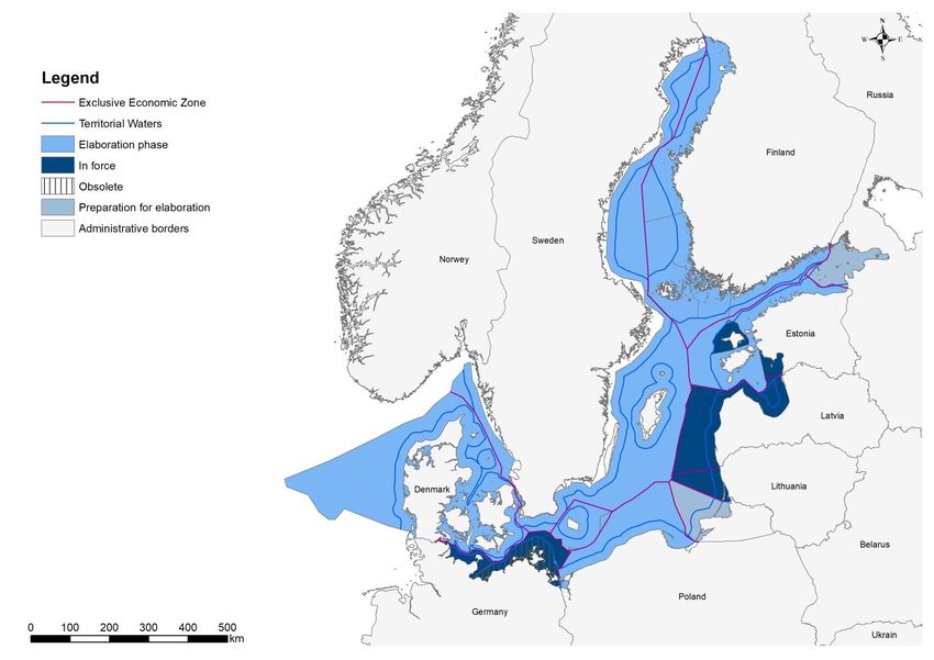
Table of Contents
Table of Contents .................................................................................................. 3
1.      Introduction ................................................................................................... 5
2.      Methodology of the assessment ..................................................................... 6
     2.1.     Desk study .................................................................................................................. 6
     2.2.     Survey......................................................................................................................... 7
     2.3.     Interviews................................................................................................................... 7
     2.4.     Interactive workshop, March 2019 ............................................................................ 7
     2.5.     Pan Baltic Scope Planning Forum, May 2019............................................................. 7
     2.6.     Workshop, October 2019 ........................................................................................... 7
     2.7.     Involved target groups of the assessment ................................................................. 7
3.      Status of the MSP process in the Baltic Sea countries ..................................... 8
4.      Implementation of the MSP principles...........................................................10
     4.1.     Sustainable management ........................................................................................ 12
     4.2.     Ecosystem approach ................................................................................................ 14
     4.3.     Long term perspective and objectives ..................................................................... 16
     4.4.     Precautionary principle ............................................................................................ 18
     4.5.     Participation and Transparency ............................................................................... 20
     4.6.     High quality data and information basis .................................................................. 22
     4.7.     Planning adapted to characteristics and special conditions at different areas ....... 23
     4.8.     Transnational coordination and consultation.......................................................... 23
     4.9.     Coherent terrestrial and maritime spatial planning ................................................ 24
     4.10. Continuous planning ................................................................................................ 24
5. Application of Guidelines on transboundary consultations, public participation
and co-operation .................................................................................................26
     5.1.     Scope of transboundary consultation ...................................................................... 26
     5.2.     Coherence of maritime spatial plans ....................................................................... 26
     5.3.     Timing of the MSP transboundary consultation process ......................................... 28
     5.4.     Information and knowledge sharing ........................................................................ 29
     5.5.     Transboundary consultation strategy ...................................................................... 31
     5.6.     Stakeholder involvement ......................................................................................... 33
     5.7.     Informal transboundary cooperation processes ..................................................... 34
     5.8.     Main challenges and proposals for improvement ................................................... 35
     5.9.     Good practices ......................................................................................................... 35
6. Evaluation of MSP Roadmap ............................................................................36
     6.1. Evaluation of the MSP Roadmap .................................................................................. 36
     6.2. Implementation of the HELCOM-VASAB MSP WG Plan ............................................... 42

                                  Assessment of Application of Baltic Sea Common Regional Maritime Spatial Planning Framework
                                                                                                                                             3
6.3. Proposals for future activities of MSP Roadmap beyond 2020.................................... 43
Key conclusions and recommendations ................................................................45
Annex 1. Survey template ....................................................................................46
Annex 2. Interview template ................................................................................53

List of Tables
Table 1. Status of the MSP process ........................................................................................... 8
Table 2. MSP principles and minimum requirements according to the EU MSP Directive ..... 10
Table 3. Validity of the maritime spatial plans and revision schedule. ................................... 17
Table 5. An overview of public participation and access to information (as of Dec 2019) ..... 20
Table 6. Frequency of the review of the plan as defined by legislation.................................. 25
Table 7. Maritime issues assessed in transboundary context to avoid misalignments .......... 27
Table 8. Steps were taken to inform neighbouring countries about your MSP process ........ 30
Table 9. Overview on evaluation of the implementation of the MSP Roadmap .................... 36

List of Figures
Figure 1. Common Regional MSP Framework ........................................................................... 5
Figure 2. Methodology of the Assessment................................................................................ 6
Figure 3. Status of the MSP process in the Baltic Sea. (based on HELCOM web-service
23.09.2019)................................................................................................................................ 9
Figure 4. Launch of transboundary consultation process (spring 2019) ................................. 29
Figure 5. Self-evaluation of information provision and communication efforts..................... 33

                                  Assessment of Application of Baltic Sea Common Regional Maritime Spatial Planning Framework
                                                                                                                                           4
1. Introduction
The Assessment of the application of the Baltic Sea Common Regional Maritime Spatial
Planning Framework (hereafter – Assessment) was implemented in the frame of the EU-
funded project Pan Baltic Scope (http://www.panbalticscope.eu/). The Pan Baltic Scope
project lasted from January 2018 to December 2019. The partnership was formed by 12
partners representing national authorities responsible in MSP and relevant macro-regional
organizations.
The Assessment was implemented as one of the activities, namely Activity 1.1.4. Follow-up
of Common Regional Framework, and is led by VASAB Secretariat. However, it has synergies
and a need for communication with other activities, for example, Activity 1.1.1. Planning
Forum, 1.2.1. Ecosystem-based Toolbox, 1.3. Integrating Land Sea Interactions into MSP. It
was also important to recognise that the Assessment should support Joint HELCOM-VASAB
Maritime Spatial Planning Working Group (MSP WG) in fulfilling the current Work Plan 2017-
2019 and designing the up-coming one for 2020-2021.
The Baltic Environmental Forum – Latvia (BEF-Latvia) was contracted by the State Regional
Development Agency of Latvia (VASAB Secretariat) to carry out the Assessment. The BEF-
Latvia sub-contracted Hendrikson & Ko, Estonia, to support the implementation of the
Assessment.
The objective of the Assessment was to analyse the application, implementation,
achievements and possible future adjustments to update the joint regional framework for
the Maritime Spatial Planning (MSP) process in the Baltic Sea Region (BSR):
1) Baltic Sea Broad-Scale Maritime Spatial Planning Principles (MSP Principles),
2) Guidelines on transboundary consultations, public participation and co-operation
(Guidelines),
3) Regional Baltic Maritime Spatial Planning Roadmap 2013-2020 (Roadmap).
Figure 1. Common Regional MSP Framework
The geographical scope of the assessment: marine waters of the countries around the Baltic
Sea – Denmark, Estonia, Finland, Germany, Latvia, Lithuania, Poland, Russia, Sweden.
The duration of the contract – October2018-December2019.
Assessment of Application of Baltic Sea Common Regional Maritime Spatial Planning Framework
52. Methodology of the assessment
The implementation of the Assessment demanded to apply several methods, which were
relevant to all three components of the Assessment. The experts used available published
information and reports as well as on-line survey, interviews, face-to face meetings and
workshops. Also, direct experiences and emerging ideas from the on-going MSP process
were used. The assessment was carried out in close cooperation with the VASAB Secretariat,
HELCOM-VASAB MSP WG and other activities of the Pan-Baltic Scope project.
Figure 2. Methodology of the Assessment
2.1. Desk study
VASAB Secretariat regularly collects the MSP Country Fiches in BSR and they are made
available on VASAB and HELCOM websites. The link: https://vasab.org/theme-
posts/maritimespatial-planning/msp-country-fiches/.
European MSP platform also presents information on EU Member States, including the Baltic
Sea countries. The link: https://www.msp-platform.eu/.
The progress in cooperation and MSP implementation is also reflected in the Outcomes from
HELCOM-VASAM MSP WG bi-annual meetings.
The countries present information on their national websites, mostly in national languages.
Information on transboundary relevance is also presented in English.
In recent years, several scientific publications have been dedicated to MSP approaches and
tools as well as to evaluating experiences and presenting lessons learned. The relevant
conclusions for the Assessment from scientific papers have been considered in this report.
Conclusions from relevant transboundary projects have also been screened during the
Assessment.
Assessment of Application of Baltic Sea Common Regional Maritime Spatial Planning Framework
62.2. Survey
The survey focused on implementation aspects of the Guidelines. The template is presented
in Annex 1. In January 2019, an online survey form was created and sent to contact persons
in charge of MSP in the countries. The list of the contact persons was updated in the 17th
HELCOM-VASAB MSP Working Group meeting in Riga on 14-15 November, 2018 (Annex 3 of
the Outcome of the meeting).
2.3. Interviews
The interview as a method was selected to contribute to evaluating the implementation of
the Roadmap. The specific objectives of the interview were:
• to clarify the implementation status of the MSP Roadmap in the BSR countries
and on pan-Baltic level. The main information will have been obtained by the
desk study, but during the interview the gathered facts shall be verified.
• to identify and propose possible future tasks to include in the MSP Roadmap,
indicated the future scope for regional cooperation.
The target group of the interview was the HELCOM-VASAB WG members. Additional
interviews were held, based on the outcomes of the interactive workshop in March-April
2019. The guiding interview questions are presented in Annex 2.
2.4. Interactive workshop, March 2019
An interactive workshop to collect opinions on implementation of the MSP Principles and
the Guidelines was held as an event organized by VASAB Secretariat back-to-back with
HELCOM-VASAB MSP WG on 27 March 2019 in Hamburg, Germany. The BEF-Latvia and
Hendrikson & Ko in collaboration with VASAB Secretariat prepared contents for the
workshop and moderated the sessions. The target group of the workshop was the HELCOM -
VASAB MSP WG members.
2.5. Pan Baltic Scope Planning Forum, May 2019
A dedicated session to present the interim results on the Assessment and to conduct
facilitated discussion was organized during the 6th Planning Forum of the Pan Baltic Scope
project on 29 May. The working session focused on the MSP principles and proposing good
examples. The target groups of the event were planners from the Baltic Sea region countries
and Pan Baltic Scope project experts.
2.6. Workshop, October 2019
The BEF-Latvia presented the results of the Assessment and participated in the discussion on
the Roadmap, future mandate and workplan of HELCOM-VASAB MSP WG and the input to
HELCOM Baltic Sea Action Plan. The workshop took place as a part of the HELCOM-VASAB
MSP WG Meeting held on 28-29 October 2019 in St. Petersburg, Russia.
2.7. Involved target groups of the assessment
The Assessment depended on fruitful cooperation of the assessment team with key public
stakeholders of the MSP sector in the Baltic Sea region. The input from public competent
authorities involved in MSP was particularly important to achieve desired quality of the
assessment of the three components of the regional framework. Several institutions are
Assessment of Application of Baltic Sea Common Regional Maritime Spatial Planning Framework
7competent authorities for MSP in the Baltic Sea region and represent their countries in the
HELCOM-VASAB MSP WG. Figure 2 above shows the involvement of stakeholders in
providing input to the Assessment and corresponding applied methods and acitvities: desk
study (literature and available data review), interviews, survey, interactive workshops. The
activities were coordinated with other Pan Baltic Scope project activities.
3. Status of the MSP process in the Baltic Sea
countries
The map displaying the status of the MSP process in different countries was developed
based on the categories and data published in the HELCOM Data and Map services. The
process steps to assess the progress in MSP are defined according to the INSPIRE Directive
2007/2/EC and the Guidelines on transboundary MSP output data structure in the Baltic Sea
(See Table 1).
Table 1. Status of the MSP process
Process step Definition
Preparation for Plan in the process of preparation - no official decision to elaborate the
elaboration plan yet, but legislation is in place and/or preparatory work for MSP has
been launched (preparation of the ToR, context analysis etc.).
Elaboration Plan is under elaboration – the decision on starting the plan has been
phase taken by responsible authority and officially announced.
In force Plan is already adopted and legally binding or active.
Obsolete Plan has been substituted by another plan or is not any longer in force.
Available spatial data in the HELCOM Data and Map services:
Data was collected within HELCOM-VASAB Data Expert Sub-group activities and related
support by Pan Baltic Scope project and stored at HELCOM portal as BASEMAPS for MSP in
the Baltic Sea. The data layer “maritime spatial plan area” shows the actual process in
development of MSP in the Baltic Sea region.
Assessment of Application of Baltic Sea Common Regional Maritime Spatial Planning Framework
8Figure 3. Status of the MSP process in the Baltic Sea (December 2019)
Assessment of Application of Baltic Sea Common Regional Maritime Spatial Planning Framework 94. Implementation of the MSP principles
“Baltic Sea broad-scale maritime spatial planning principles” (further in the text – the MSP principles) were
adopted by HELCOM Heads of Delegations meeting on 8-9 December 2010 and by VASAB Committee on
Spatial Planning and Development of the Baltic Sea Region on 13 December 2010. Ten principles were
adopted aiming to provide valuable guidance for achieving better coherence in the development of MSP
systems in the Baltic Sea Region. The joint document lists the principles as well as provides definitions. It
needs to be highlighted that the MSP principles were adopted well before the EU MSP Directive
(2014/89/EU).
The EU MSP Directive contains minimum requirements for MSP that are also related to the MSP principles
(see Table 2) as the content of the principles has largely been integrated in the legal text of the directive.
Therefore, all EU Member States when transposing provisions of the EU MSP directive into national
legislation also integrate the HELCOM-VASAB MSP principles to some extent. The principle “Long term
perspective and objectives” is especially noteworthy. Considering the proposed MSP review period of at
least every ten years, the intention of the directive is that planning has long-term time horizon.
The deadline for transposition of the MSP Directive in national legislation and designation of competent
authorities was 18 September 2016. All EU Member States around the Baltic Sea have transposed the
requirements of the MSP directive and notified on that the European Commission by 2018. By November
2019, legislation on MSP has not yet been adopted in the Russian Federation.
Table 2. MSP principles and minimum requirements according to the EU MSP Directive
HELCOM-VASAB MSP principles EU MSP Directive, minimum requirements and the
text.
Sustainable management Article 6, subparagraph 2(b): take into account
1. environmental, economic and social aspects, as well as
safety aspects.
2. Ecosystem approach Recital (13); Article 5, point 1.
3. Long term perspective and objectives -
4. Precautionary Principle Recital (14)
Participation and Transparency Article 6, subparagraph 2(d): ensure the involvement of
5.
stakeholders.
High quality data and information basis Article 6, subparagraph 2(e): organise the use of the
6.
best available data.
Transnational coordination and Article 6, subparagraphs 2(f): ensure trans-boundary
7. consultation cooperation, and 2(g): promote cooperation with third
countries.
10Coherent terrestrial and maritime Article 6, subparagraphs 2(a): take into account land-sea
spatial planning interactions, and 2(c): aim to promote coherence
between maritime spatial planning and the resulting
8. plan or plans and other processes, such as integrated
coastal management or equivalent formal or informal
practices.
Article 4, point 1.
Planning adapted to characteristics and Article 4, point 5 “…Member States shall have due
special conditions at different areas regard to the particularities of the marine regions,
9. relevant existing and future activities and uses and their
impacts on the environment, as well as to natural
resources…”
Continuous planning Article 6, paragraph 3 “…plans shall be reviewed by
10.
Member States at least every ten years…”
As discussed with representatives of the competent authorities at the workshop in March 2019 in
Hamburg, the role of the MSP principles can be seen differently. In general, the HELCOM-VASAB principles
shall be treated as valuable guidance, on the other hand, the document outlines specific tasks to be
undertaken during MSP. Generally, the representatives agreed that the principles should be ‘held in the
back of our minds’ as guiding statements.
One of the main conclusions of the 1st interactive workshop was that the HELCOM-VASAB principles were
working well and there were no major amendments needed. The group suggested to avoid adding new
principles, but rather to integrate the emerging statements and new knowledge in the existing ones.
Enhancement or further guidance for implementation would be needed for some of the principles. For
example, the compensation for “lost access” or “impact on” resources could be addressed as a new
emerging issue, potentially in relation to the precautionary principle. At the same time, the issue should be
handled as a sensitive topic since it hints to significant impacts that need to be compensated. Although
good environmental status and climate change were mentioned as important issues with MSP relevance,
the participants did not consider it necessary to define them as separate principles since they are
connected to almost all the existing MSP principles.
In the Pan Baltic Scope’ s Planning Forum in Tallinn, participants stated again that the MSP principles were
still valid, whereas definitions could be amended based on gained practical experience in MSP over the past
years.
During the discussions in both events different weight of the principles was revealed. The Ecosystem
Approach was believed to be the overarching or ‘umbrella’ principle. The same stands for the principle on
sustainable management. It was recommended to create a structure of the MSP principles that would
illustrate the relationships between them.
The links to MSP Global initiatives shall be looked at in future. Some of the global issues (principles or goals)
might be relevant for the Baltic Sea region. The Global perspective could be integrated after the 3rd MSP
Forum, which is organized in cooperation with VASAB and UNESCO in November 2019.
In general, “Coherence of MSP” needs to be clarified among the competent authorities of the Baltic Sea as
maritime spatial plans are/will be with different legal status, either a guiding or binding document. The
issues were also discussed at the 18th HELCOM-VASAB MSP WG held on 27-28 March 2019 in Hamburg.
Assessment of Application of Baltic Sea Common Regional Maritime Spatial Planning Framework 11As presented in Chapter 3, Baltic Sea countries are at different stages of the MSP process. Consequently,
the application of the MSP principles has not yet taken place to full extent. The assessment of the MSP
below is built on the practices and experiences gained so far.
4.1. Sustainable management
Maritime Spatial Planning is a key tool for sustainable management by balancing between economic,
environmental, social and other interests in spatial allocations, by managing specific uses and coherently
integrating sectoral planning, and by applying the ecosystem approach. When balancing interests and
allocating uses in space and time, long-term and sustainable management should have priority.
The MSP Directive establishes a framework for maritime spatial planning aimed at promoting sustainable
growth of maritime economies, sustainable development of marine areas and sustainable use of marine
resources. When establishing and implementing maritime spatial planning, Member States shall consider
economic, social and environmental aspects to support sustainable development and growth in the
maritime sector, applying an ecosystem-based approach, and to promote coexistence of relevant activities
and uses.
The HELCOM-VASAB MSP principle highlights MSP as a management tool, which seems to be a less
ambitious role than imposed by the MSP directive, which defines it as promotion of sustainable growth,
development and use. The definition of this principle consists of two sentences that are not fully consistent
in the message. Whereas the first sentence could be understood as definition of “sustainable
management” having three components: balancing interests, integrating sectorial planning and applying
ecosystem approach, the second sentence states that for balancing interests “sustainable management”
should have a priority. Also, the term ‘specific uses’ needs to be clarified.
Nowadays social aspects are expanded also by cultural dimension, representing intangible values and
heritage to be safeguarded on one hand and considered as a resource on the other hand within MSP. This
aspect could be highlighted also in the description of this principle.
When balancing interests or promoting sustainable growth, development and use, the MSP could
encourage multi-use approach and spatial efficiency. This aspect also could be highlighted by this principle.
Recommendation: The definition requires revision to ensure consistency in the
message as well as to integrate additional new, emerging issues of sustainable
management.
The word ‘sustainable’ is very commonly used in planning process. However, it is not frequent for plans to
demonstrate explicitly their contribution to sustainable development or management. Therefore, an
indicator approach and appraisals could be used for ex-ante (benchmarking) as well as interim or ex-post
evaluations.
Good example: Sustainability Appraisal of the draft MSP of Swedish waters 1. The
report presents the assessment results according to three dimensions of
sustainability: economic, social and environmental, and selected criteria.
1
https://www.havochvatten.se/hav/uppdrag--kontakt/publikationer/publikationer/2019-05-07-
hallbarhetsbeskrivning-av-forslag-till-havsplaner-for-sverige.html
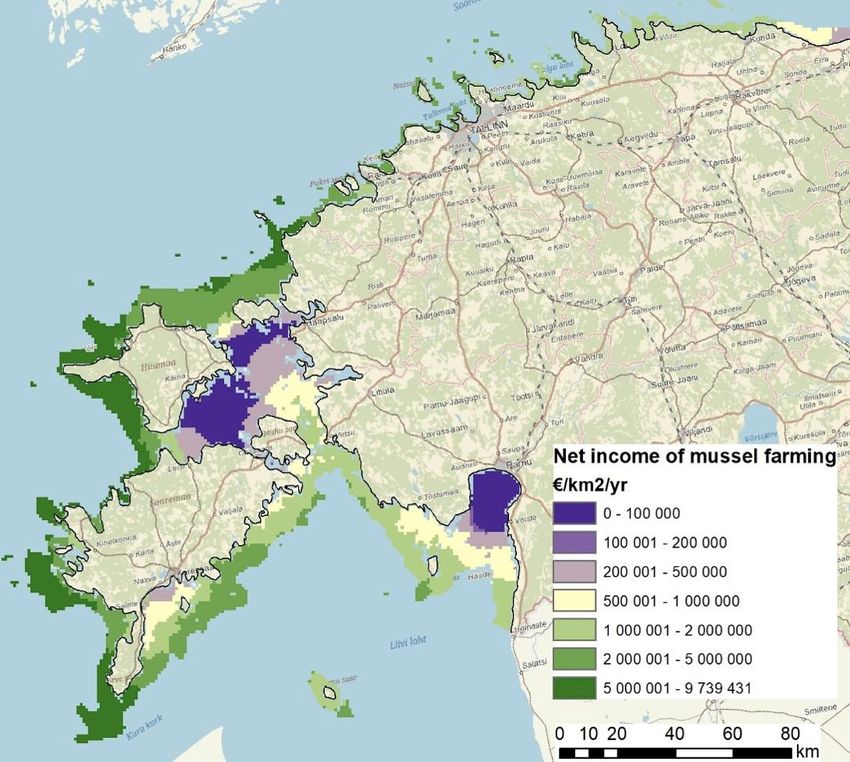
Assessment of Application of Baltic Sea Common Regional Maritime Spatial Planning Framework 12Good example: Web-based application on integrating economy model with
cumulative impacts for development of Estonian MSP.
PlanWise4Blue www.sea.ee/planwise4blue is a web-based application developed during
the compilation of the Estonian national MSP for improved decision-making.
PlanWise4Blue combines models of marine economy and cumulative impact assessment.
Such a combined model allows one to assess the economic benefits of various
management scenarios along with their environmental impact across Estonian sea space.
Outcomes of the model make it possible to work towards sustainable solutions to
maximize the economic benefit gained from the use of marine resources with minimum
damage to the environment. The aim of the economy model is to increase the capacity
for knowledge-based management of marine resources and accounting for their potential
economic benefits. The aim of the cumulative impact model is to identify various human
pressures and account for their cumulative effects on the natural environment, while
considering regional differences of nature. The spatial resolution of the model is 1 km2,
and the temporal timescale is 1 year. This tool has been developed to assist with maritime
spatial planning but is also applicable in other fields.
Assessment of Application of Baltic Sea Common Regional Maritime Spatial Planning Framework 13PlanWise4Blue output example
4.2. Ecosystem approach
The ecosystem approach, calling for a cross-sectoral and sustainable management of human activities, is an
overarching principle for Maritime Spatial Planning which aims at achieving a Baltic Sea ecosystem in good
status - a healthy, productive and resilient condition so that it can provide the services humans want and
need. The entire regional Baltic Sea ecosystem as well as sub-regional systems and all human activities
taking place within it should be considered in this context. Maritime Spatial Planning must seek to protect
and enhance the marine environment and thus should contribute to achieving Good Environmental Status
according to the EU Marine Strategy Framework Directive and HELCOM Baltic Sea Action Plan.
Country representatives recognise the “Ecosystem approach” as an “umbrella” or overarching principle as
already stated in its definition.
To ensure consistency in terms with the EU MSP Directive, it has been proposed to rename the principle to
‘ecosystem-based approach’ (EBA). The adopted guidelines on this issue have already introduced and
adopted EBA term. The same term would ensure consistency of the HELCOM-VASAB documents.
Assessment of Application of Baltic Sea Common Regional Maritime Spatial Planning Framework 14This principle is linked to the above described principle of “sustainable development” which states that
application of the ecosystem approach is one of the components to ensure sustainable management.
The definition of this principle is derived from the Convention of Biological Diversity, that endorsed the
description of the ecosystem approach and operational guidance and recommended the application of the
principles and other guidance on the Ecosystem Approach in its COP5 meeting in 2000.2 The 12 principles of
the ecosystem approach were elaborated in a Workshop on the Ecosystem Approach held in Lilongwe,
Malawi, 26-28 January 1998, thus these principles are very often refer to as the Malawi principles on
ecosystem approach.
In 2003, HELCOM and OSPAR adopted a joint statement of their common vision of the ecosystem approach
to managing human activities impacting the marine environment (an “ecosystem approach”) in their
maritime areas.3 The ecosystem approach was defined as “the comprehensive integrated management of
human activities based on the best available scientific knowledge about the ecosystem and its dynamics, in
order to identify and take action on influences which are critical to the health of marine ecosystems,
thereby achieving sustainable use of ecosystem goods and services and maintenance of ecosystem
integrity”. This definition is broader compared to the MSP principle on the ecosystem approach defined
above.
In order to create a common understanding on how the ecosystem approach can be applied in drawing up
a spatial plan for a sea area in accordance with spatial planning legislation in force in the Baltic Sea
countries, the “Guideline for the implementation of ecosystem-based approach in Maritime Spatial
Planning (MSP) in the Baltic Sea area” was adopted by the 72nd meeting of VASAB CSPD/BSR on 8 June
2016 and approved by HELCOM HOD 50-2016 on 15-16 June 2016. The guideline presents the main steps of
the maritime spatial planning process and the relevant tasks to be carried out for applying an ecosystem-
based approach.
Pan Baltic Scope project has carried out an assessment of the Guidelines on Ecosystem
Approach in relation to Malawi principles as well as in relation to the scientific
literature on the ecosystem approach. The key conclusion is that the Guidelines could
be potentially amended to address the issue of uncertainty and precaution in a more
systematic fashion, ensuring that public participation processes enable genuine two-
way communication and avoid capture by particularly resourceful or articulated
interests, as well as increasing transparency concerning trade-offs among users and
interest.4
The guideline points out that some key elements of the ecosystem-based approach are integrated more
specifically into the strategic environmental assessment (SEA) (Chapter 5 of the Guideline). Therefore, the
implementation of SEA for MSP strengthens the ecosystem-based approach in MSP as well. Recital 23 of
MSP Directive states: “Where maritime spatial plans are likely to have significant effects on the
environment, they are subject to Directive 2001/42/EC.” The Directive 2001/42/EC on the assessment of
the effects of certain plans and programmes on the environment requires that “an environmental
assessment shall be carried out for all plans and programmes which are prepared for agriculture, forestry,
fisheries, energy, industry, transport, waste management, water management, telecommunications,
tourism, town and country planning or land use and which set the framework for future development
consent of projects listed in Annexes I and II to Directive 85/337/EEC” (Article 3, paragraph 2 of the
2
Secretariat of the Convention on Biological Diversity (2004) The Ecosystem Approach,
(CBD Guidelines) Montreal: Secretariat of the Convention on Biological Diversity 50 p.
3
https://www.ospar.org/site/assets/files/1232/jmm_annex05_ecosystem_approach_statement.pdf
4
David Langlet and Aron Westholm. Department of Law, University of Gothenburg. 2019. Synthesis report on the
ecosystem approach to maritime spatial planning. Pan Baltic Scope project.
Assessment of Application of Baltic Sea Common Regional Maritime Spatial Planning Framework 15Directive 2001/42/EC). In practice, this means that MSP is a subject of SEA for EU Member States. The
country representatives participating in the assessment activities have pointed out that the added value for
EBA compared to SEA shall be explained in more details.
Good example: Pan Baltic Scope project supported the implementation of EBA through
SEA procedure. The project carried out a study on SEA, looking into the Southern Baltic
Sea region with a transboundary perspective on Denmark, Sweden and Poland. The
report will be available at www.panbalticscope.eu
The MSP principle on EBA expects that Maritime Spatial Planning must seek to protect and enhance the
marine environment and thus should contribute to achieving Good Environmental Status (GES) according to
the EU Marine Strategy Framework Directive (MSFD) and HELCOM Baltic Sea Action Plan. Currently, the link
between MSP and GES is weak. The key challenge is to address the pollution reduction targets as the
activities are mainly land based, whereas MSP scope is marine areas. There is a need to highlight the efforts
of synchronizing data inputs for MSP and MSFD. The limitation to contribute to achievement of good
environmental status was recognized already at an early stage of the development of MSP in the Baltic Sea
region. Only some of the MSFD good environmental status descriptors are sensitive to the MSP instruments
and measures; therefore, only those relevant should be subject to further examinations by MSP5.
To support the implementation of this aspect of the EBA, HELCOM GEAR Group in 2018 produced a report
that outlines the Roadmap of the HELCOM region coordination to ensure implementation of ecosystem
approach.
The EBA can be applied in planning as well as in implementation (e.g., permitting) phase. Different
conditions shall be respected and need to be explained and highlighted in more detail.
Recommendation: The definition requires a revision as it states that “overarching
principle for Maritime Spatial Planning which aims at achieving a Baltic Sea ecosystem
in good status” is rather unfeasible, considering that main pollution sources are land
based, thus the potential contribution to achieving good ecosystem status is rather
limited in its scope. Nevertheless, it is important to highlight the importance of MSP in
contributing to achieving GES based on the MSP instruments and mandate.
4.3. Long term perspective and objectives
Maritime Spatial Planning should have a long-term perspective in relation to the goals it seeks to attain and
to its environmental, social, economic and territorial effects. It should aim for long-term sustainable uses
that are not compromised by short term benefits and be based on long-term visions, strategies and action
plans. Clear and effective objectives of Maritime Spatial Planning should be formulated based on these
principles and national commitments. The establishment of a legal basis for Maritime Spatial Planning in
the Baltic Sea countries should be investigated including vertically and horizontally well-coordinated
decision making processes concerning sea space uses to ensure efficient implementation of maritime spatial
plans and to provide for an integrated sea space allocation process when such plans do not yet exist.
Maritime Spatial Planning should have a long-term perspective in relation to the goals although continuous
changes and impacts occur in an extended or virtually unbounded period of time. There is no common
5
Zaucha, J., & Matczak, M. (2012). Identification of maritime spatial planning best practices in the Baltic Sea Region
and other European Union maritime regions. MaritimeInstitute in Gdańsk, Gdańsk.
Assessment of Application of Baltic Sea Common Regional Maritime Spatial Planning Framework 16agreement among the Baltic sea countries on what is meant by ‘long-term’. The time perspective depends
on the type of MSP. If the document is more strategic and vision and goal oriented, the time period is
longer and can be linked to overall strategic planning time horizons in the country, e.g. 2030 or 2050. If the
document contains specific objectives and targets to be achieved and tasks to be implemented, the time
period for validity of MSP might be shorter, e.g. 10 -15 years.
The EU MSP Directive indicates that plans shall be reviewed at least every ten years. Reviews are carried
out based on an adaptive management approach and not necessarily reflect the time horizon of maritime
spatial planning. However, a 10-year period can be also considered a long-term perspective since average
sectorial policies are most often planned for a 6-year period, bound to financial planning periods of the
European Union. Moreover, there were strong EU policies developed with focus on achievements by 2020;
while the further long-term policy perspective at EU level (post-2020) is still debated.
As environmental data are crucial for development of MSP, including the application of the EBA, it is also
relevant to synchronize the MSP revision with the MSFD revision phase. The latter is the same for the
whole EU, which is a 6-year cycle: 2021 – 2027. The synchronisation would also support the
implementation of the MSP principle of “continuous planning”.
The participants of the HELCOM-VASAB MSP WG and the Planning Forum acknowledged that long-term
planning is an important principle of MSP. However, the difficulty is phased in communication with
sectorial representatives who are lacking their long-term perspective objectives, thus having challenges in
defining clear long-term interests in MSP. The long-term perspective is a very challenging element if MSP
has a strong local stakeholder involvement component. Local inhabitants are very often interested to foster
and promote blue growth sectors as soon as possible, thus ensuring better jobs and income in the short
term. MSP can also be seen as a communication means that helps to explain to the involved parties the
relevance and unavoidability of a long-term perspective in planning sea space.
The EU MSP Directive requires that the first plans are established by 31 March 2021, which is the final
deadline; whereas Member State can adopt the plan according to individually determined process, e.g.,
Latvia adopted the plan in 2019 and Mecklenburg-Vorpommern in 2016. Thus, the time horizon of
maritime spatial plans is not harmonised between the countries. The goal of HELCOM -VASAB Regional MSP
Roadmap is to draw up and apply maritime spatial plans throughout the Baltic Sea Region by 2020.
Table 3. Validity of the maritime spatial plans and revision schedule.
Country Validity of the plan (in years or by the date)
Denmark To be developed by 2021, towards 2030.
Estonia -
Finland -
Germany EEZ Adopted in 2009, valid for 10 years, revision in 2019.
Germany (Mecklenburg-Vorpommern) Adopted in 2016, valid for 10 years.
Germany (Schleswig-Holstein) Adopted in 2010, valid until 2025, new plan under
elaboration.
Latvia 12 years, valid until 2030.
Lithuania Valid until 2020, new one under elaboration for 2030.
Poland Drafted, to be valid until 2030 as linked to the
implementation of the Maritime Policy.
Assessment of Application of Baltic Sea Common Regional Maritime Spatial Planning Framework 17Russia -
Sweden New proposal to be elaborated every 8 years. Target
year 2030, vision year 2050.
Åland, Finland A revision of the MSP is to be elaborated every 6 years.
First plan to be adopted by 2021.
Recommendation: revision of the definition is not needed with regard to the long-term
perspective.
This MSP principle calls for clear and effective objectives to be formulated by a Maritime Spatial Plan. The
effectiveness of the objectives could be assessed by the use of measurable indicators that would also allow
to follow the implementation progress and achievement of the set objectives. Performance indicators are
seen as one of the key tools to measure the progress. The Pan Baltic Scope project has developed a
guidance and tested the application of the indicators for the evaluation of Latvian and Polish MSP. The
implementation of this element (issue) is closely linked to the principle of continuous planning that requires
monitoring and evaluation of the implementation of maritime plans (see section 4.10).
4.4. Precautionary principle
Maritime Spatial Planning should be based on the Precautionary Principle. This implies planning has an
obligation to anticipate potential adverse effects to the environment before they occur, taking into account
Article 3 of the Helsinki Convention, and to take all precautionary measures so that an activity will not result
in significant harm.
A similar, but distinct, forward-looking perspective should be applied with respect to the economic and
social dimensions.
The Precautionary Principle obliges the planning approach to anticipate potential adverse effects to the
environment before they occur. This principle is embedded in the Helsinki Convention, calling its
contracting parties “to take preventive measures when there is reason to assume that substances or energy
introduced, directly or indirectly, into the marine environment may create hazards to human health, harm
living resources and marine ecosystems, damage amenities or interfere with other legitimate uses of the
sea even when there is no conclusive evidence of a causal relationship between inputs and their alleged
effects.”
The EU Directive on the assessment of the effects of certain plans and programmes on the environment
(SEA Directive 2001/42/EC) also refers to the importance that Member States comply with the
precautionary principle and requires to take precautionary or mitigation measures. Therefore, a
mechanism for implementation of the precautionary principle is in place and shall been enforced by EU
Member States for many years.
In 2000, the European Commission published the Communication on the precautionary principle
(COM/2000/0001 final).6 The document aims to establish guidelines for applying the principle. One of
points is that of the precautionary principle, which is essentially used by decision-makers in the
management of risk meaning that potentially dangerous effects deriving from a phenomenon, product or
6
https://eur-lex.europa.eu/legal-content/EN/TXT/?uri=LEGISSUM%3Al32042
Assessment of Application of Baltic Sea Common Regional Maritime Spatial Planning Framework 18process have been identified, and that scientific evaluation does not allow the risk to be determined with
sufficient certainty.
Hiiumaa county MSP: the Supreme Court of Estonia revoked the Hiiumaa county MSP
plan concerning prospective offshore wind farm development areas. According to the
court, the failure to offer a precise enough assessment of environmental impacts
cannot be substantiated with the argument that the plans of the developers and
details of their actions in implementing the plan, such as the number of turbines, their
capacity and height, are not known for certain. It said that in assessing the impacts of
a plan it is crucial what activity, at what location and on what scale the state is
planning and considering possible in principle in the plan, not on what scale and how
exactly the developers will actually carry out the plan. The court found that in the
framework of the SEA, the impacts of the wind turbines as well as the cables
connecting them with the mainland and their links to other activities have not been
established and relevant surveys have not been conducted. This includes the failure to
conduct an assessment necessary to determine the impacts of the planned activities
on Natura areas and protected species. The court also pointed out that this does not
mean that the SEA has to find out all the conditions to the details and establish all
possible parameters if it is more appropriate to decide them later in the application
phase. As a result of the planning procedure, the state had to become confident that,
the designated areas would be suitable, at least under certain conditions, for wind
energy production. It was also necessary to be convinced that there are no better
alternatives to wind energy production. Therefore, the decision to establish the plan
regarding wind energy development areas is not legitimate, according to the Supreme
Court.7
The SEA also contributes to the implementation of the EBA approach. The HELCOM-VASAB guidelines on
the EBA8 present a strong integration perspective between the SEA and the application of the EBA.
Therefore, the principle has been conceptually embedded twice.
Recommendation: a debate whether the precautionary principle shall be kept as a
distinct principle or included within the EBA as practical application is strongly linked
to the EBA and the SEA. This requires additional discussion based on expected
outcomes of the Pan Baltic Scope project.
During the interactive workshop, it was pointed out that the socio-economic aspects need clarification as
the principle is mainly applied in the context of environmental protection.
Recommendation: clarification is needed with regard to the last sentence “A similar,
but distinct, the forward-looking perspective should be applied with respect to the
economic and social dimensions.” Otherwise, the sentence is rather repetitive of the
message in the MSP principle of sustainable development.
7
http://www.tuuleenergia.ee/en/2018/08/estonias-top-court-revokes-hiiumaa-wind-farms-plan/
8
HELCOM-VASAB MSP Working Group, Guideline for the implementation of ecosystem based approach in Maritime
Spatial Planning (MSP) in the Baltic Sea (2016); http://www.helcom.fi/action-areas/maritime-spatial-planning/msp-
guidelines/
Assessment of Application of Baltic Sea Common Regional Maritime Spatial Planning Framework 194.5. Participation and Transparency
All relevant authorities and stakeholders in the Baltic Sea Region, including coastal municipalities as well as
national and regional bodies, should be involved in maritime spatial planning initiatives at the earliest
possible stage, and public participation should be secured. Planning processes should be open and
transparent and in accordance with international legislation.
A number of EU Directives and policy instruments set out requirements in relation to public participation.
Some are detailed, while others follow a more general approach. This MSP principle is also in line with the
MSP Directive article 9 on the Public participation. The MSP directive requires that the Member States shall
establish means of public participation by informing all interested parties and by consulting the relevant
stakeholders and authorities, and the public concerned at an early stage in the development of maritime
spatial plans, in accordance with relevant provisions established in the Union legislation.
Another important legal piece for the EU Member States is the Public Participation Directive 2003/35/EC
which sets obligations arising under the Århus Convention, in particular by (a) providing for public
participation in respect of the drawing up of certain plans and programmes relating to the environment; (b)
improving the public participation and providing for provisions on access to justice. The MSP directive
refers to the Directive 2003/35/EC as good example of public consultation provisions.
Table 4. An overview of public participation and access to information (as of Dec 2019)
Country Information to Commenting period Consultation & involvement
general public mechanism
Denmark A draft plan shall Six months, but may be Plan shall be draw up involving other
be published deviated in special cases. ministries affected and with the
only digitally. involvement of coastal municipalities
General public and coastal regions as well as any
comments only digitally. relevant business and interest
organisations.
Estonia Compulsory Wider public as well as Plan is prepared in cooperation with
public displays any stakeholder has the ministries, authorities and national
on the website right to express their associations of local authorities.
of the authority. opinion about the plan in
every phase of the Any person who expresses an
planning process. interest is invited to participate in
the development of the plan and
Initial phase must not be notifies the authority of the method
shorter than 30 days. of communicating notices.
Public meetings
required. Compulsory discussions are held in
different stages of the planning
Draft MSP commenting process
phase at least 30 days.
Finland The plan shall be At least 30 days for The plan is developed in cooperation
published on the expressing comments. by regional authorities. Additionally,
internet. everyone can express their interest
to participate.
Åland, Finland The plan is 1st round of The plan is developed in cooperation
published consultations lasts 2 with departments of the
digitally, but it months. Government of Åland as well as
will be municipalities, stakeholders, and
Assessment of Application of Baltic Sea Common Regional Maritime Spatial Planning Framework 20reformatted into 2nd round of sector representatives. Close cross-
a printable consultations lasts 2 border collaboration with Finland is
document. months. also highlighted in the MSP work.
The public and other parties are
invited to give opinion on the
proposals and background material.
Germany EEZ The adopted Commenting period lasts Broad public participation was
plan (2009) is at least 1 month. organised through consultations with
published on the stakeholders (agencies and NGOs).
internet.
Draft plan shall
be publicly A public hearing on the draft plan
available, also was held in Rostock in late 2008.
electronically.
Germany (Mecklenburg- The plan (2016) Commenting period lasts Two rounds of broad participation
Vorpommern) is published on at least 1 month. processes with regional conferences.
the internet
Germany (Schleswig- The plan (2010) Commenting period lasts Several public stakeholder meetings
Holstein) is published on at least 1 month. in different parts of Schleswig-
the internet. Holstein.
A new plan is in
preparation.
Latvia A plan published Not shorter than 30 A special MSP working group
only digitally on days. The draft plan was consisting of representatives from
governmental consulted in 2 rounds: relevant ministries, public
platforms and 18.12.2015-31.01.2016. administration, regional and local
websites. and 27.07.-27.08.2019. coastal municipalities, as well NGOs
(about 30 members).
Lithuania The plan is Official public hearings, ad hoc
published on the meetings with specific groups,
internet. individual negotiations. The plan was
adopted by the Parliament, thus a lot
of involvement of politicians.
Poland The draft plan The draft plan The stakeholder consultations are
was displayed consultation: organized in several rounds along
for public 27.12.2018-13.02.2019. the MSP development process.
hearing in
maritime offices National consultation Zero draft plan was consulted
and published meeting on 15.01.2019. intensively with different
on the internet. stakeholders in June 2017. Eight
specialised meetings (i.e. discussing
concrete problems such as
navigation or fishing in offshore wind
farms) and one meeting for the
general public were organised in the
autumn of 2017.
Russia - - -
Assessment of Application of Baltic Sea Common Regional Maritime Spatial Planning Framework 21Sweden The drafts are 1st round of MSP shall be produced in close
published on consultations lasted 6 cooperation by SwAM with National
SwAM website. months (15.02.2018- Board of Housing, the Swedish Board
15.08.2018). of Agriculture, national agencies
The adopted responsible for national interests,
plan shall be 2nd round of and county administrative boards.
made available consultations Other relevant national agencies,
for public by (examination) lasted 3 municipalities and regional councils
SwAM. months (14.03.2019- are invited in the process.
15.08.2019).
Any party (also public) is invited to
give its opinion on the proposals.
Recommendation: revision of the definition is not needed.
4.6. High quality data and information basis
Maritime Spatial Planning should be based on best available and up to date comprehensive information of
high quality that to the largest extent possible should be shared by all. This calls for close cooperation of
relevant GIS and geo-statistical databases, including the HELCOM GIS, monitoring and research in order to
facilitate a trans-boundary data exchange process that could lead to a harmonised pan-Baltic data and
information base for planning. This base should cover historical baselines, present status as well as future
projections of both environmental aspects and human activities. It should be as comprehensive, openly
accessible and constantly updated as possible and compatibility with European and Global initiatives should
be ensured.
The importance of high-quality data and information basis is acknowledged by all BSR countries. Therefore,
considerable efforts are allocated to collect and store data at national and/or regional level. Nevertheless, a
lack of data (especially environmental data) is one of the planning constraints. Information on technologies
and future innovations in marine sea uses is another constraint in the process.
Data sharing is an important requisite to ensure that MSP is coherent across borders. A HELCOM-VASAB
MSP Data Experts Subgroup (Data ESG) has been established under the HELCOM-VASAB MSP WG to
support data, information and evidence exchange for MSP processes with regard to cross-
border/transboundary planning issues. In order to facilitate coherent MSP process, the Guidelines on
transboundary MSP output data structure in the Baltic Sea (elaborated by the HELCOM-VASAB MSP Data
ESG) emphasizes the need for transboundary consultations at an early stage to avoid costly misalignments
and negative environmental impacts, as well as to promote efficiency gains and synergies. The guidelines
were agreed on by the joint HELCOM-VASAB MSP Working Group in its 17th meeting on 14-15 November
2018, Riga, Latvia and adopted by the VASAB CSPD/BSR in its 80th meeting on 22-23 January 2019,
Schwerin, Germany.
The countries have agreed to work towards a common Baltic MSP web-map. The HELCOM-VASAB MSP
Data ESG is working on elaborating Baltic Sea MSP web-map9 (BASEMAPS) https://basemaps.helcom.fi/ -
map service to access data relevant to Baltic Sea maritime spatial planning from the original sources where
it is stored.
The same spatially relevant information with download function is also available at HELCOM Map and Data
service http://maps.helcom.fi/website/mapservice/ . However, the most recent and nationally available
9
https://basemaps.helcom.fi/
Assessment of Application of Baltic Sea Common Regional Maritime Spatial Planning Framework 22data might not yet be published on this platform; therefore it is also advisable to contact neighbouring
countries directly, if cross-border data and information is needed.
The work on data sharing is also supported by the EU Directive 2007/2/EC of the European Parliament and
of the Council of 14 March 2007, establishing an Infrastructure for Spatial Information in the European
Community (INSPIRE Directive), which aims at making data harmonized and published in open standard
format across all EU countries by the end of 2020. INSPIRE Directive defines datasets which should be
harmonized and published.
Recommendation: the headline could be revised by replacing “High quality” with “Best
available” as it is rather difficult to judge whether data has high quality.
4.7. Planning adapted to characteristics and special conditions at different
areas
Maritime spatial planning should acknowledge the characteristics and special conditions of the different
sub-basins of the Baltic Sea and their catchments. Consideration should be taken of the need for separate
sub-regional planning adapted to such areas, including sub-regional objectives supplementing regional
objectives specified in Principle 3. In general, maritime spatial plans should seek coherence across
ecosystems.
Maritime spatial planning should acknowledge the characteristics and special conditions of the different
sub-basins of the Baltic Sea and their catchments. This principle is implemented in several BSR countries
where marine waters are divided accordingly.
Sweden is elaborating three maritime spatial plans: Bothnian Bay, Baltic Sea and Western Waters
(Skagerrak/Kattegat).
In addition to its national MSP, Poland elaborates maritime plans for Szczeciński Lagoon and Kamieński
Lagoon, as well as Maritime Spatial Plans for Vistula Lagoon.
In Finland, there will be three plans: one for the northern Bothnian Sea, Quark and Bothnian Bay, one for
the Archipelago Sea and southern Bothnian Sea, and the third for the Gulf of Finland.
The Government of Åland, having jurisdiction over the autonomous region of the Åland Islands in Finland, is
to plan the territorial sea areas of the Åland Islands. The Åland Islands MSP is independent from the Finnish
MSPs and is drafted based on its own legislation.
Recommendation: revision of the definition is not needed
4.8. Transnational coordination and consultation
Maritime spatial planning should be developed in a joint pan-Baltic dialogue with coordination and
consultation between the Baltic Sea states, bearing in mind the need to apply international legislation and
agreements and, for the HELCOM and VASAB EU member states, the EU acquis communautaire. Such
dialogue should be conducted in a cross-sectoral context between all coastal countries, interested and
competent organizations and stakeholders. Whenever possible, maritime spatial plans should be developed
and amended with the Baltic Sea Region perspective in mind.
Assessment of Application of Baltic Sea Common Regional Maritime Spatial Planning Framework 23You can also read