Identifying electronic platforms to increase safety at sea in the Australian commercial fishing fleet
←
→
Page content transcription
If your browser does not render page correctly, please read the page content below
Identifying electronic platforms to increase
safety at sea in the Australian
commercial fishing fleet

                                                  Geoff Diver

                                             September 2019

                                     FRDC Project No 2018-106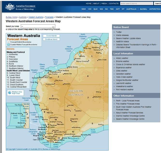
© 2019 Fisheries Research and Development Corporation.
All rights reserved.

ISBN 978-0-6486705-0-6

Identifying electronic platforms to increase safety at sea in the Australian commercial fishing fleet

FRDC Project No 2018-106
2019

Ownership of Intellectual property rights
Unless otherwise noted, copyright (and any other intellectual property rights, if any) in this publication is owned by the
Fisheries Research and Development Corporation

This publication (and any information sourced from it) should be attributed to Diver, G., Diversity
Sustainable Development Consultants, 2019, Identifying electronic platforms to increase safety at
sea in the Australian commercial fishing fleet, Canberra, September.

Creative Commons licence
All material in this publication is licensed under a Creative Commons Attribution 3.0 Australia Licence, save for
content supplied by third parties, logos and the Commonwealth Coat of Arms.

                                Creative Commons Attribution 3.0 Australia Licence is a standard form licence
                                agreement that allows you to copy, distribute, transmit and adapt this publication
                                provided you attribute the work. A summary of the licence terms is available from
                                creativecommons.org/licenses/by/3.0/au/deed.en. The full licence terms are available
                                from creativecommons.org/licenses/by/3.0/au/legalcode.

Inquiries regarding the licence and any use of this document should be sent to: frdc@frdc.com.au

Disclaimer
The authors do not warrant that the information in this document is free from errors or omissions. The authors do not
accept any form of liability, be it contractual, tortious, or otherwise, for the contents of this document or for any
consequences arising from its use or any reliance placed upon it. The information, opinions and advice contained in
this document may not relate, or be relevant, to a readers particular circumstances. Opinions expressed by the
authors are the individual opinions expressed by those persons and are not necessarily those of the publisher,
research provider or the FRDC.

The Fisheries Research and Development Corporation plans, invests in and manages fisheries research and
development throughout Australia. It is a statutory authority within the portfolio of the federal Minister for Agriculture,
Fisheries and Forestry, jointly funded by the Australian Government and the fishing industry.

 Researcher Contact Details                                            FRDC Contact Details
 Name:        Geoff Diver                                              Address:     25 Geils Court
 Address:     10 Lachlan Way                                                        Deakin ACT 2600
              Bibra Lake WA 6163                                       Phone:       02 6285 0400
 Phone:       0418 266 065                                             Fax:         02 6285 0499
 Fax:                                                                  Email:       frdc@frdc.com.au
 Email:       geoffdiver@iinet.net.au                                  Web:         www.frdc.com.au

In submitting this report, the researcher has agreed to FRDC publishing this material in its edited form.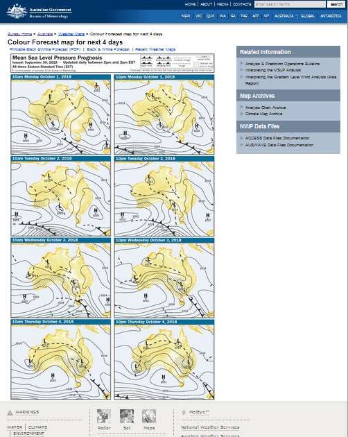
Foreword
This report is dedicated to all the men and women who go to sea as part of the Australian fishing
industry. Too many of these people lose their lives in pursuit of their profession. They leave
behind family, loved ones and friends. Their passing is also keenly felt by all fishers across the
country. The report also goes out to the departed.

Birds and Ships
The birds are singing in your eyes today
Sweet flowers blossom in your smile
The wind and sun are in the words you say
Where might your lonesome lover be?
Birds may be singing in my eyes this day
Sweet flowers blossoms when I smile
But my soul is stormy
And my heart grows wild
My sweetheart rides a ship on the sea
Well, my soul is stormy and my heart grows wild
Where might my lonesome lover be?

Songwriters: Billy Bragg / Woody Guthrie
Birds and Ships lyrics © Sony/ATV Music Publishing LLC, BMG Rights Management

Acknowledgements
This research has been funded by the Fisheries Research and Development Corporation without
which it may never had occurred. The research involved consultation with several government
agencies including the Australian Maritime Safety Authority, the Australian Fisheries
Management Authority, and the Bureau of Meteorology. I would like to acknowledge the
expertise that these agencies brought to the project. The views contained in this report are
those of the author and not attributable to, or associated with any stakeholder.
Input was also provided from members of the Australian fishing industry, both as individuals but
also as part of larger entities such as companies of Professional Fisher Associations. Thank you
to all those who contributed.
There is no doubt in my mind that this project would not have eventuated without the significant
energy put into it by the families and friends of those lost at sea from the tragedies which befell
the FV Returner and the FV Dianne, and from the survivor of the FV Dianne tragedy.
It is impossible to convey the profound grief felt by these people over the loss of their loved
ones. But it is an enormous statement of character these people have channelled this grief in a
direction which seeks to ensure that no one else must suffer in a similar manner to themselves.
I feel very grateful to have been taken into their confidence, to hear their stories, to be invited to
memorial services and to visit coastal memorials installed in the honour of their loved ones. I
would like to sincerely thank each and every one of those people.
The families also expressed confidence in my ability to deliver constructive and beneficial
outcomes. I hope I have met these expectations. Geoff Diver.

                                                     i
Contents
Foreword ............................................................................................................................... i

Acknowledgements .............................................................................................................. i

Contents ............................................................................................................................... ii

Abbreviations ...................................................................................................................... iv

Executive Summary ............................................................................................................. v

Recommendations ............................................................................................................ viii

Introduction .......................................................................................................................... 1

Objectives ............................................................................................................................. 3

Method .................................................................................................................................. 4

Results .................................................................................................................................. 5
     Basic Principles ................................................................................................................ 5
        Search and Rescue .................................................................................................... 5
        COSPASS/SARSAT ................................................................................................... 6
        Global Maritime Distress Signalling System................................................................ 6
     Electronic Platforms ......................................................................................................... 8
        Vessel Monitoring Systems ........................................................................................ 8
        Automatic Identification System .................................................................................. 9
        Emergency Position Indicating Radio Beacons......................................................... 10
        Personal Locator Beacons ........................................................................................ 12
        Satellite Emergency Notification Device ................................................................... 12
        “Man Overboard” Systems........................................................................................ 12
        Radio ........................................................................................................................ 13
        Telephone ................................................................................................................ 13
        Email ........................................................................................................................ 13
     Bureau of Meteorology ................................................................................................... 14
        General Overview ..................................................................................................... 14
        Communication options ............................................................................................ 18
        MetEye ..................................................................................................................... 19
     Weather Apps ................................................................................................................ 22
Discussion .......................................................................................................................... 23

Conclusion ......................................................................................................................... 31
     Objective 1. To identify an electronic platform which can accurately and automatically
     receive a signal from Australian fishing vessels wherever they operate to determine in
     a timely manner if the vessel is still able to receive and transmit a signal ....................... 31
     Objective 2. To determine a protocol for timely action if a signal has been deemed to
     be lost ............................................................................................................................ 32
     Objective 3. To identify an electronic platform which can alert skippers of heightened
     risks from fast developing, or fast changing weather and sea conditions ........................ 32

                                                                        ii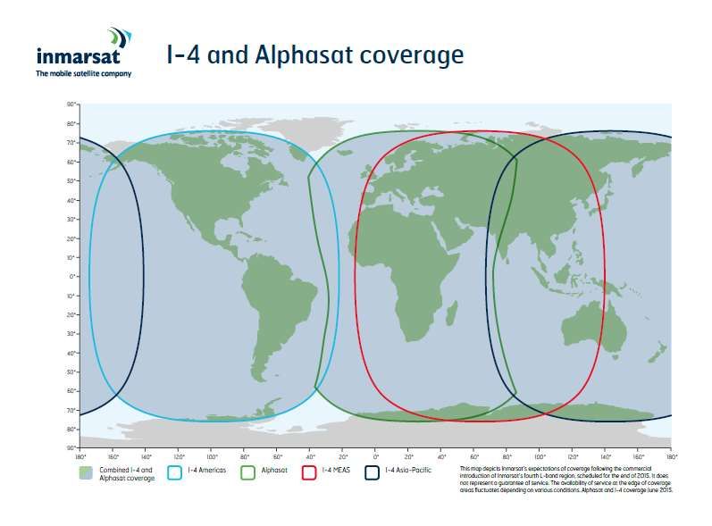
Objective 4. To make recommendations for the integration of these platforms into
     regulation through Australian maritime and fisheries jurisdictions ................................... 32
     Other .............................................................................................................................. 33
Implications ........................................................................................................................ 34

Extension and Adoption .................................................................................................... 35
     Project coverage ............................................................................................................ 35

Figures
Figure 1. Australian Search and Rescue Region. ........................................................................ 5
Figure 2. COSPAS-SARSAT System. ......................................................................................... 6
Figure 3. GMDSS Overview. ....................................................................................................... 7
Figure 4. Inmarsat Maritime I-4 and Alphasat Coverage Areas. .................................................. 7
Figure 5. Vessel Monitoring System Overview. ........................................................................... 8
Figure 6. VMS ALC unit............................................................................................................... 9
Figure 7. AIS System Overview................................................................................................... 9
Figure 8. AIS Receiving Unit. .................................................................................................... 10
Figure 9. Water/Manually Activated EPIRB (L), Manually Activated EPIRB (R). ........................ 11
Figure 10. Float Free EPIRB. .................................................................................................... 11
Figure 11. Maritime PLB............................................................................................................ 12
Figure 12. Man Overboard System. © Raymarine ..................................................................... 13
Figure 13. Sample of BoM 4 Day Synoptic Chart ...................................................................... 14
Figure 14. Default Screen for BoM Satellite Viewer ................................................................... 15
Figure 15. Sample of the BoM Rain Radar ................................................................................ 15
Figure 16. BoM WA Coastal Waters Map .................................................................................. 16
Figure 17. BoM definitions for the time of day ........................................................................... 17
Figure 18. BoM definitions for wind warnings ............................................................................ 17
Figure 19. BoM definitions for sea conditions ............................................................................ 17
Figure 20. BoM definitions for swell conditions .......................................................................... 18
Figure 21. MetEye Coverage Map ............................................................................................. 20
Figure 22. MetEye Forecast by Location (user defined) ............................................................ 20
Figure 23. MetEye Wind Speed and Direction Forecast by Location (user defined) .................. 21
Figure 24. MetEye Total Wave Height Forecast by Location (user defined) .............................. 21
Figure 25. Rain Radar Comparison: BoM (L) and a Generic Weather App (R) ......................... 22
Figure 26, Summary Matrix of Electronic platforms ................................................................... 23
Figure 27. Generic Risk Matrix .................................................................................................. 29

                                                                       iii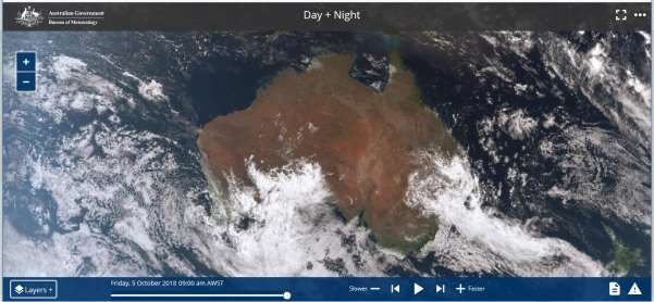
Abbreviations
AFMA – Australian Fisheries management Authority
AIS – Automatic Identification System
ALC – Automatic Location Communicator
AMSA – Australian Maritime Safety Authority
BoM – Bureau of Meteorology
COSPAS-SARSAT – Translated from Russian “COsmicheskaya Sisteyama Poiska Avariynich
Sudov and meaning “Space System for Search of Distress Vessels”, and “Search and Rescue
Satellite-Aided Tracking”)
DSC – Digital selective calling
EPIRB – Emergency Position Indicating Radio Beacon
GEOSAR – Geostationary orbit search and rescue (with reference to satellite orbits)
GNSS – Global Navigation Satellite System
LEOSAR – Low earth orbit search and rescue (with reference to satellite orbits)
MEOSAR – Medium altitude orbit search and rescue
NSCV – National Standard for Commercial Vessels
MOB – Man Overboard
MMSI – Maritime Mobile Service Identity
PFD – Personal Flotation Device
PLB – Personal Locator Beacon
RCC – Rescue Coordination Centre
SAR – Search and rescue
SEND – Satellite Emergency Notification Device

SMS – Safety Management System
SOLAS – (Convention for) Safety of Life At Sea
UHF – Ultra High Frequency
VHF – Very High Frequency
VMS – Vessel Monitoring System

                                               iv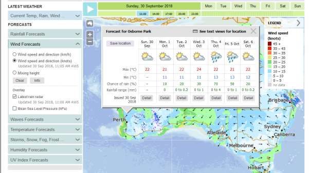
Executive Summary
This project has its genesis in the tragic loss of life at sea within the Australian fishing industry.
In recent years there have been a number of instances where vessels have been lost causing
the deaths of a significant number of fishers. In some cases, the vessels were lost before the
crew could activate the vessel’s Emergency Positioning Radio Beacon (EPIRB). EPIRB forms
the basis for the formal search and rescue (SAR) agencies in Australia, and the absence of an
EPIRB signal can significantly diminish the effectiveness of a search and rescue mission.
Recognising this, the purpose of this report was to examine other electronic platforms typically
found on fishing vessels and to investigate if these could be incorporated into a process, policy,
or procedure which could increase the maritime safety of the Australian fishing fleet.
This research was conducted with the full cooperation and support of the families of those lost at
sea, and a sole survivor from a catastrophic loss of a vessel off Queensland. The research also
involved consultation with key commonwealth government agencies such as the Australian
Fisheries Management Authority, the Australian Maritime Safety Agency, and the Bureau of
Meteorology.
The formal Objectives of the report were:
1. To identify an electronic platform which can accurately and automatically receive a signal
from Australian fishing vessels wherever they operate to determine in a timely manner if the
vessel is still able to receive and transmit a signal
2. To determine a protocol for timely action if a signal has been deemed to be lost
3. To identify an electronic platform which can alert skippers of heightened risks from fast
developing, or fast changing weather and sea conditions
4. To make recommendations for the integration of these platforms into regulation through
Australian maritime and fisheries jurisdictions
Maintaining safety at sea requires a multi-faceted and complex system including coordinating
vessel integrity and the carriage of the correct equipment, the provision of accurate information
on weather and sea conditions, the training of the crew and managing their actions at sea.
Providing a swift and professional response when a vessel is in distress requires a similarly
complex system of an alert being issued by the vessel, the capacity of the SAR authorities to be
able to accurately pinpoint the location of the vessel in a timely manner, and having the
necessary interagency structures to launch a rescue mission.
Australian commercial fishing vessels are required by law to carry a range of electronic platforms
before they go to sea. Depending on the size, survey classification and fishery of activity of the
vessel, the minimum requirements usually include:
Emergency position indicating radio beacons (EPIRB)
Very high frequency (VHF) radio transmitters and/or High Frequency (HF) radio
Additional equipment often found on the modern fishing vessel includes:
Vessel monitoring systems (VMS)
Automatic Identifier Systems (AIS)
Personal locator beacons (PLB)
“Man Overboard” (MOB) systems
Satellite Emergency Notification Device (SEND)
Mobile telephones
Satellite telephones
v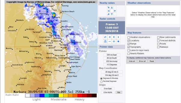
Internet access via satellite
In analysing these electronic platforms, this report has concluded that EPIRB should remain the
primary distress signalling platform for Australian fishing vessels. EPIRB signals are monitored
globally by dedicated SAR authorities which have the expertise and resources to triage the initial
distress signal, and coordinate a SAR mission.
EPIRBs can be purchased as manually activated models, water activated, or as float free units
which deploy automatically if the unit is immersed in between 1 and 4 metres of water.
The National Standard for Commercial Vessels (NSCV) has been updated with “float free”
EPIRBs now becoming mandatory on some vessels by January 1, 2021.
Where mandated in Australia, a VMS is used as a fisheries management compliance tool, not as
a maritime safety device. The report found that VMS is not a suitable primary distress signalling
platform. The principle reasons behind this finding include:
Not all Australian fisheries management agencies mandate VMS units which have email
communication or in built distress signalling capabilities
VMS units will lose signal if the ship loses power
There are often delays in the transmission of the VMS signal from the satellite earth
station to the end user
VMS may continue to transmit in emergency situations such as a fire, or a ship running
aground and braking up.
PLB transmit on the same frequency as EPIRBs. They can transmit for 24 hours but do not float
vertically. PLB should be attached to the upper section of a life jacket with a lanyard to ensure
they don’t float away from the user. The report found PLB increase the safety of the individual
user, but not the vessel as a whole.
SEND have a range of technical characteristics which make them a less suitable sea safety
platform than PLB. Of note, these devices:
May require battery changes, possibly while the user is in the water;
Would need to be re-activated by the user after a battery change;
Require the user to maintain an individual contract with a satellite provider;
Are not directly monitored by Australia’s SAR authorities.
Similar to PLB and SEND, MOB systems increase individual crew safety but not the safety of the
vessel as a whole. MOB systems immediately alert the parent vessel a crew member has gone
overboard which should shorten the window of time that person is in the water. As with PLB and
SEND, MOB systems are only effective if the crew wear the device on deck, and have it tethered
to their clothing.
The Automatic Identification System was also found not to be a suitable substitute for EPIRBs.
Automatic Identification System units can be switched off by the Master of a vessel.
Communication means such as radio, email and satellite phones would all lose functionality if
the vessel lost power. Mobile phones would only be of use if the vessel is in range of a
provider’s signal. An emergency “Triple zero” call can be made on an Australian phone and will
be picked up by any mobile phone carrier. This requires the vessel in distress to be within range
of a mobile phone tower.
The report found the Bureau of Meteorology provides a wide array of services of use to
mariners. It is likely some of these are not widely known throughout the Australian fishing
vi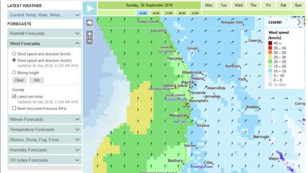
industry. The main services of use to the industry are discussed in the report and
recommendations on how best to disseminate this knowledge to the Australian fishing industry
are made.
The report also discusses other safety issues such as the development of a safety management
system, and other quantitative risk assessment processes. FRDC projects 2017-046 “What’s
stopping you from protecting yourself and your mates? Identifying barriers to the adoption of
safe work practises in the small-scale wild catch commercial fishing industry”, and 2017-194
“SeSAFE - delivering industry safety through electronic learning” are mentioned in the
discussion section of this report as they have relevance for identifying some of the at sea risks
likely to appear in fishing operations, and the development of training options for industry,
respectively.
The implications from the report’s findings include (among others):
There are a number of recommendations which will require liaison between the
Australian fishing industry and government agencies. Some of these agencies already
have formal consultation bodies designed specifically to work with the industry;
There are a number of recommendations which are aimed solely at industry. These
recommendations can be taken up as initiatives “for industry, by industry”
There seem to be no significant impediments to achieving substantial progress on the
findings of the report.
The report makes 14 recommendations which are listed below, and in the body of the report.
vii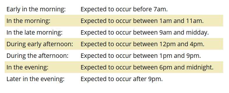
Recommendations
Recommendation 1. It is recommended the Australian fishing industry and/or the entire
maritime community develop a campaign raising awareness of the benefits of float free EPIRB
and encourage vessel owners to install such units in a timely manner.

This campaign could also include highlighting the safety benefits to individual crew members
available through PLB, SEND and MOB systems, and the limitations of each in using either as a
distress signalling platform.

Recommendation 2. It is recommended AMSA and manufacturers on float free EPIRBs
continue developing detailed installation instructions to mitigate the probability of a float free
EPIRB becoming entangled in the vessel’s structure in the case of maritime emergencies such
as a vessel overturning.

Recommendation 3. It is recommended the Australian fishing industry and or the wider
maritime community develop a campaign nominating a specific date at which EPIRB or PLB
owners should review and update the contact details registered against their beacon serial
number.

Recommendation 4. It is recommended that the Australian fishing industry, AMSA and State
and Commonwealth fisheries agencies work towards an annual risk based audit which
correlates the contact details held by AMSA and the various fisheries management agencies for
fishing vessels. It is not a recommendation of this report that the audit cover all vessels fitted
with VMS and EPIRB every year. This recommendation will require the involvement of both
AMSA and State and Commonwealth fisheries agencies and it is noted that legal privacy
requirements may limit the exchange of such information between the two agencies.

Recommendation 5. It is recommended that the Australian fishing industry ensure that all crew
on a vessel are formally made aware of the location and activation method of all EPIRB or PLB
on board as part of their occupational health and safety (OHS) induction when they join the
vessel. The same process should be undertaken for all passengers (scientists, observers etc.)
who go to sea on a vessel.

Recommendation 6. It is recommended that Australian fisheries management agencies pass
on information on the loss of a VMS signal, and the last known position to the relevant SAR
authority under a formal protocol including timeframes for each action.

Recommendation 7. It is recommended that Australian fisheries management agencies
investigate mechanisms to automate an alert system which can notify the relevant officer of the
loss of a VMS signal out of hours, and link the immediate actions to Recommendation 6.

Recommendation 8. It is recommended the Australian fishing industry investigate the
formation of an industry funded VMS platform to operate on a subscriber basis to spread satellite
polling costs. This recommendation is tempered by the fact vessels would need to purchase
their own VMS units, and such a platform would need to be staffed and resourced and may be
open to professional liability claims should it be promoted as a formal sea safety entity.

The Australian fishing industry should also continue to monitor the prospect of owners being
able to access the fishery management agency’s VMS signal for their vessel without paying for
satellite monitoring costs, and to take advantage of such an outcome if or when it becomes
available.

Recommendation 9. It is recommended the Australian fishing industry develop an information
package on protocols between vessels and shore based representatives which integrate AIS
into sea safety initiatives with an emphasis on protocols to attempt to differentiate between a

                                                viii
loss of signal as a result of a maritime emergency or due to manual switch off of the AIS, or a
technical fault.
Recommendation 10. It is recommended the Australian fishing industry encourage its
members to develop induction packages for their crew which include the location of radios, email
facilities, satellite phones, and fixed mobile phones. The induction could also include knowledge
of the monitored VHF digital selective calling (DSC) emergency channels on VHF radio, and that
triple zero can be called from any Australian mobile phone if it is in range of any phone carrier.
Induction should also involve crew members being informed of who the trained radio operators
on-board are.
Recommendation 11. It is recommended the Australian fishing industry, in conjunction with the
BoM, consider developing an information package on the various services offered by the BoM
and the technical terms used by the BoM for marine forecasts and warnings. It is recommended
this module be available to all crews and shore based representatives to enable them to be able
to contribute to sea safety decision making if there are concerns with weather and sea
conditions while at sea.
Recommendation 12. It is recommended the Australian fishing industry urge vessel operators
and owners to develop a data driven risk based decision making matrix based on the definitions
of BoM terminology and specific to the vessel size, area of operation, fishing gear etc. It is
recommended that all crew on-board are made aware of the matrix and understand it.
Recommendation 13. It is recommended the Australian fishing industry continue to work with
AMSA and the BoM in designing a system of determining and transmitting information on rapidly
deteriorating, localised weather events.
Recommendation 14. It is recommended the Australian fishing industry promote a positive
safety culture within the industry. The use of SeSAFE modules can address fishery or area
specific safety issues and these modules be made available as part of the normal induction and
training packages for crew.
Keywords
Safety at sea, search and rescue, fishing industry, emergency position indicating radio beacon,
EPIRB, Personal locator beacon, vessel monitoring system, electronic platforms.
ixIntroduction
Maintaining safety at sea requires a multi-faceted and complex system including coordinating
vessel integrity and the carriage of the correct equipment, the provision of accurate information on
weather and sea conditions, the training of the crew and managing their actions at sea. Providing
a swift and professional response when a vessel is in distress requires a similarly complex system
of an alert being issued by the vessel, the capacity of the search and rescue (SAR) authorities to
be able to accurately pinpoint the location of the vessel in a timely manner, and having the
necessary interagency structures to launch a SAR mission.
Australian commercial fishing vessels are required by law to carry a range of electronic platforms
before they go to sea. Depending on the size, survey classification and fishery of activity of the
vessel, the minimum requirements usually include:
Emergency position indicating radio beacons (EPIRB)
Very high frequency (VHF) radio and/or High Frequency (HF) radio
Additional equipment often found on the modern fishing vessel includes:
Vessel monitoring systems (VMS)
Automatic Identifier Systems (AIS)
Personal locator beacons (PLB)
“Man Overboard” (MOB) systems
Satellite Emergency Notification Device (SEND)
Mobile telephones
Satellite telephones
Internet access via satellite
Despite this, a number of Australian fishing vessels have sunk at sea resulting in the loss of life of
crew members. Two such vessels were the FV Dianne which was lost off Queensland in 2017,
and the FV Returner which sunk off Western Australia in 2015. Both vessels sank without the crew
activating any of the emergency systems known to be on-board at the time. In the case of the
Returner, a series of events identified by the Western Australian Coroner led to there being a delay
of 5 days between when all forms of electronic signal were lost, and a formal SAR mission was
commenced. Some of these events were raised by various Coroners who made recommendations
centred on the sharing of information between fisheries management and SAR agencies.
Recommendations for the sharing of information have since been taken up in Western Australia.
There is no doubt that interagency cooperation exists in Australia, and that there is an appetite to
continually refine ways in which this can be built upon to increase safety at sea. This was clearly
and publicly shown in the manner which several agencies adopted the recommendations of the
Western Australian Coroner following the inquest into the loss of the Returner, and has been amply
demonstrated by the cooperation of the various agencies consulted as part of this research.
Despite having its origins partly in the loss of the FV Dianne and the FV Returner, this report cites
neither as case studies, although it does draw on the observations of the families of those lost, and
the survivor of one of the tragedies. The report does examine the suite of mandatory and voluntary
electronic platforms available to the Australian fishing industry and how these might be configured
to best serve the safety of those at sea. The key players in such a configuration may include the:
Shore based representatives and families of vessel crew
Skippers and crews themselves
Australian Maritime Safety Authority (AMSA)
Commonwealth and State and Territory fisheries management agencies around the country
Bureau of Meteorology (BoM)
1 State and Territory police and emergency services
Voluntary coast guard radio operators
The report details some basic principles which the reader needs to be aware of in order to
understand the sections of the report which follow. The Basic Principles section is followed by a
technical overview of Electronic Platforms, which are either mandated for Australian fishing
vessels, or can be carried voluntarily. It is important to note that the extent of the electronic
platforms carried on a fishing vessel through regulation is dependent on the survey class of the
vessel. The survey class is largely determined by the vessel size and its area of operation. The
technical detail of survey requirements for each vessel class are too complex to present in a report
such as this. As a result, this section deals with all the key electronic platforms but specifically
identifies equipment which is voluntary across all survey classes. The integration of these
platforms into sea safety regimes is presented in the Discussion section of this report which also
presents the Recommendations in the context of the discussion surrounding each facet
investigated.
2Objectives
The formal objectives of this project were to:
1. To identify an electronic platform which can accurately and automatically receive a signal from
Australian fishing vessels wherever they operate to determine in a timely manner if the vessel
is still able to receive and transmit a signal.
2. To determine a protocol for timely action if a signal has been deemed to be lost
3. To identify an electronic platform which can alert skippers of heightened risks from fast
developing, or fast changing weather and sea conditions
4. To make recommendations for the integration of these platforms into regulation through
Australian maritime and fisheries jurisdictions
3Method
This research was conducted with the full cooperation and support of the families of those lost at
sea, and a sole survivor from a catastrophic loss of a vessel off Queensland, and the families of
those who perished in the loss of a fishing vessel off Western Australia.
The research also involved consultation with key Commonwealth government agencies such as
the AMSA, Australian Fisheries Management Authority (AFMA) and the BoM. A range of
technology suppliers were also approached for technical and logistic input. These included the
makers of safety equipment, and providers of other technologies such as software and satellite
systems. Members of the Australian Fishing industry were also consulted.
This information was then synthesised by the author and reviewed by a number of stakeholders.
The views contained in this report are those of the author and not attributable to, or associated with
any stakeholder.
4Results
Basic Principles
Search and Rescue
Search and rescue (SAR) functions refer to the specific activities of terrestrial, aviation and
maritime responses to distress signals. International SAR activities are coordinated through the
International Convention on Maritime Search and Rescue which was adopted on 27 April 1979 and
came into force on 22 June 1985.
The convention further codified treaties such as the International Convention for the Safety of Life
at Sea (SOLAS), which had previously required vessels at sea to respond to distress signals, and
formally linked existing SAR organisations in member countries.
Once a distress signal is detected, it is relayed to the member nation responsible for SAR missions
in that area. AMSA are the official SAR agency for the Australian zone shown in Fig. 1.
Figure 1. Australian Search and Rescue Region. Reproduced with the permission of AMSA.
In broad terms, mounting a SAR mission can involve:
Transmitting the location of the distress calls to aircraft, ships and terrestrial craft in the
vicinity of the distress signal;
Coordinating activities with other agencies with SAR capability such as State and Territory
police services, Borderforce and the armed services
5 Coordinating the movement of “assets” such as agency owned and aircraft, ships and
terrestrial vehicles
Liaison with medical facilities and services.
COSPASS/SARSAT
The COSPAS-SARSAT satellite system (translated from Russian “COsmicheskaya Sisteyama
Poiska Avariynich Sudov and meaning “Space System for Search of Distress Vessels”, and
“Search and Rescue Satellite-Aided Tracking”) is an international SAR network formed under the
SOLAS convention and is used by the 44 nation member nations – including Australia.
The system covers maritime, terrestrial and aircraft distress signals. A system overview is shown
below in Figure 2. The COSPAS-SARSAT forms a major part of the Global Maritime Distress and
Safety System (GMDSS).
The general SAR satellite configuration is a combination of low earth orbit search and rescue
(LEOSAR) satellites, geostationary orbit search and rescue (GEOSAR) satellites within the
medium-altitude Earth Orbit Search and Rescue system (MEOSAR). The system is shown below
in Figure 2. By and large the SAR satellite coverage extends to about 80o north and 80o south.
Figure 2. COSPAS-SARSAT System. Source www.COSPAS-SARSAT.int
Global Maritime Distress Signalling System
The Global Maritime Distress Signalling System (GMDSS) is the maritime component of the
COSPAS-SARSAT system with an overview of the system shown in Figure 3. GMDSS is
mandatory on vessels over 300 gross tonnage on international voyages. A number of crew in such
vessels must complete certificates of competency as a radio operator. Measures such as this
safeguard the integrity of the GMDSS.
6Figure 3. GMDSS Overview. © Asha Institute of Maritime Technology
Formal distress signals are presently carried by the Inmarsat-C satellite system. The Inmarsat
coverage zones are shown in Figure 4. The Inmarsat system uses “earth stations” to relay satellite
signals to the end user. As a result, any technical difficulties at the earth station, or in
communications between the earth station and the end user can result in a time delay which may
be as long as several hours.
Figure 4. Inmarsat Maritime I-4 and Alphasat Coverage Areas. © Inmarsat
7Electronic Platforms
Vessel Monitoring Systems
In the context of the Australian fishing industry, Vessel Monitoring Systems (VMS) is used by
government fisheries management agencies to track vessels at sea for reasons of compliance with
fisheries and other regulations such as marine reserves. Australian fisheries management
agencies do not consider VMS to be a sea safety platform. AFMA hosts the principle fisheries
VMS platform in Australia, sometimes also on behalf of the State and Territory fisheries agencies.
An overview of the VMS is shown in Figure 5.
Figure 5. Vessel Monitoring System Overview. Source: Australian Fisheries Management Authority
At its most basic a VMS has an automatic location communicator (ALC) which communicates with
a satellite system. A typical ALC is shown in Figure 6. The VMS unit is programmed to poll the
satellite at a predetermined interval. The ALC, when polling, sends the signal providing the
location of the vessel. Depending on the polling rate the ALC data can also reveal the vessels
speed and course.
More sophisticated VMS units have provision for two-way communication by email, and a manually
activated distress signal. Most of the “ALC only” units have provision for these functions to be
added by purchasing additional hardware and software.
8Figure 6. VMS ALC unit. © Polestar
With this data, the fisheries agency can monitor aspects of vessel movement such as:
Entering closed areas
Using speed and course to determining if the vessel is fishing or steaming
The vessel’s total fishing days within a fishing season
Automatic Identification System
Commercial vessels in some survey classes are required to have Automatic Identification System
(AIS) installed. AIS beacons can also be fitted to navigation markers. An overview of the AIS is
shown at Figure 7, with the on-board screen shown at Figure 8.
Figure 7. AIS System Overview. © Sail Universe
9AIS transponders and receivers use two channels referred to AIS 1 and AIS 2. These are carried
on VHF radio frequencies:
161.975 MHz (AIS1, or channel 87B) and
162.025 MHz (AIS2, or channel 88B)
An AIS will detect other AIS beacons to approximately 20 nautical miles (nm), or over a longer
range depending on how high the transponder is positioned above the water. The transponder can
also be monitored by satellite.
The AIS broadcasts a Maritime Mobile Service Identity (MMSI), a unique nine digit number that is
entered into certain marine radio communications equipment. As a unique identifier, the MMSI
assists SAR services to identify the vessel or fixed object to which the AIS is fitted. As is the case
with GMDSS, some crew on an AIS fitted vessel are required to have completed a radio operator’s
certificate of proficiency.
Figure 8. AIS Receiving Unit. © Simrad
In some cases, mariners are allowed to switch off their AIS. This occurs in the fishing industry
where skippers want to protect sensitive fishing locations. The ability for mariners to switch off
their AIS makes this system impractical as a primary distress mechanism, or to monitor vessel
movements for sea safety. As is the case with VMS, the registration of a range of contact and
identity details greatly enhances the value of the AIS.
Emergency Position Indicating Radio Beacons
Emergency Position Indicating Radio Beacons (EPIRB) are widely recognised as the best primary
distress signal platform. In Australia, EPIRBs are mandatory on all vessels operating more than 2
nm offshore. EPIRBs transmit a distress signal to the COSPAS-SARSAT system on the 406 MHz
bandwidth. The signal is then relayed to the information to the country in whose SAR Region the
emergency is taking place. Prior to February 2009, EPIRB also transmitted on the 121.5 MHz
signal. This frequency is no longer detected by satellite but is used by local SAR agencies for local
homing purposes. Prior to 1st February 2009 some analogue beacons solely transmitted on 121.5
MHz. These beacons are no longer detected by satellite.
Until recently, the most commonly found EPIRB units were manually activated by the skipper or
crew, or by immersion in water. These units are shown in Figure 9.
The National Standard for Commercial Vessels (NSCV) has been updated with “float free” EPIRB
now becoming mandatory on some vessels by January 1 2021 (https://www.amsa.gov.au/safety-
navigation/distress-beacons/mandatory-float-free-epirbs). This timeframe reflects the fact that
10these classes of vessels will have had to go through maritime survey between the implementation
of the regulation and the cut off. Float free EPIRBs still use the same transmission bandwidth but
will automatically deploy if they are subjected to a water depth between 1 and 4 metres. This
enhances the likelihood a distress signal will be sent in the event of a maritime emergency. A float
free EPIRB is shown in Figure 10.
Figure 9. Water/Manually Activated EPIRB (L), Manually Activated EPIRB (R). © GME
Figure 10. Float Free EPIRB. © GME
The correct operation of a float free ERIRB requires the unit to be installed on the vessel in a
position where it can float free of a vessel which has capsized or is sinking and is unlikely to
become entangled in the vessel structure.
EPIRBs are required to be registered with AMSA. Registration can be carried out online at
https://www.beacons.amsa.gov.au/beacons.
In future, EPIRB will also transmit on the AIS frequencies which will integrate both systems and
make it easier for vessels at sea to locate the activated EPIRB.
11Personal Locator Beacons
A similar option is the personal locator beacon (PLB) which operates more or less on the same
principle as the EPIRB but is sold as a “wearable” piece of equipment carried by an individual.
PLB transmit on the same frequency as EPIRB and thus are monitored within the international
SAR systems. A sample PLB is shown at Figure 11.
Figure 11. Maritime PLB. © GME
These devices are effective in the case of man overboard (MOB) incidents, which can occur
unseen by other crew members. For the greatest benefit, PLB should be tethered to the clothing to
ensure that it does not become separated from the position of the crew member. Most
manufacturers sell PLB specifically designed for maritime conditions
Satellite Emergency Notification Device
Satellite Emergency Notification Device (SEND) can also transmit an emergency signal.
Manufacturers of SENDs have agreement with satellite carriers with the beacon being registered at
the time of purchase. In some cases, the SEND owner needs to maintain a subscription to the
satellite carrier in order for the distress signal to be monitored. The SEND distress signal is triaged
by the satellite carrier and is then passed on to the rescue coordination centre (RCC) in the
relevant SAR area.
Many SEND also have a “tracker” function that records the movement of the wearer which can aid
a SAR mission. The tracker function uses battery life and can shorten the time for which a distress
signal can be transmitted. SEND owners are advised to carry spare batteries with the device. In
some cases, the changing of batteries will cancel the distress signal which then needs to be re-
activated. Failure to re-activate SEND after a battery change has been known to cause delays and
added complexities in SAR missions. It would prove difficult, if not impossible, to change batteries
if the SEND wearer is in the water. The reasons above work against SEND being used as a
primary distress mechanism at sea.
SEND devices are not officially or independently tested or required to be compliant to any
standard.
“Man Overboard” Systems
A number of manufacturers supply MOB alarm systems. These comprise a fixed base station on
the vessel and a number of wearable transmitters which are activated when immersed in water,
and/or move past a predetermined distance range from the base station. This is usually set at the
length of the vessel past which crew cannot physically still be on-board. When activated, the
wearable transmitters send a signal to the base station on the vessel which activates an audible
alarm. A typical MOB alarm system is shown at Figure 12.
All MOB devices have GNSS capability and transmit latitude and longitude. MOB AIS devices
transmit on the AIS frequency which assists the parent vessel in localised searches. Other MOB
12devices that transmit on different frequencies such as VHF DSC, Mobile App. The dependability of
the MOB systems relies on crew members wearing their MOB transmitter at all times when on
deck.
Figure 12. Man Overboard System. © Raymarine
Radio
The most common radios found on the Australian fishing fleet are very high frequency (VHF), and
ultra-high frequency (UHF).
VHF operates from 30 to 300 MHz (approximately 150 to 165 MHz for marine applications) and
UHF 477 MHz. UHF is also commonly referred to as CB Radio. VHF provides 77 channels, 32 of
which are allocated to repeater stations (16 Output and 16 input stations). The key maritime
frequencies for VHF are channels 16 and 70.
Not all vessels will carry UHF radios, and the only channels monitored are the (DSC) emergency
channels on VHF radio.
Telephone
Larger fishing vessels are generally fitted with a mobile telephone, often used in conjunction with a
fixed aerial. It is not uncommon for crew members to also carry their personal mobile phones on
board. Mobile phone carriers allow for “000” calls to be made as long as the phone has battery
power and is within the range of any mobile phone provider.
The range of a mobile phone from a tower is between 20 km (10.8 nm) to 70 km (37.8 nm), which
limits the use of such devices for fishing vessels operating outside this range of a phone tower.
Satellite phones, as the name implies, send the phone signal to one of multiple satellites. The
signal is then transmitted to the recipient whose response is similarly sent back to the caller via
satellite. Satellite phone owners are required to have the user to have a contract with a satellite
service operator.
Email
VMS units on Australian commercial fishing vessels that are fitted with two-way communication
functions can send and receive email but not voice messages. This level of functionality is
mandatory for vessels in survey classes which require the installation of GMDSS.
13Bureau of Meteorology1
General Overview
The BoM homepage (www.bom.gov.au) offers a range of services. At the broadest scale are
synoptic charts showing the weather patterns across the country and into surrounding seas (Figure
13). Similar information can also be viewed as a moving satellite image at
http://satview.bom.gov.au/ (Figure 14).
Figure 13. Sample of BoM 4 Day Synoptic Chart
1
All images in this section reproduced with the permission of the Bureau of Meteorology
14Figure 14. Default Screen for BoM Satellite Viewer
BOM also provides localised services such as capital city forecasts, with links to State and
Territory weather forecasts and warnings at a regional level, satellite images, rain radars (Figure
15), other climate and weather services, and the MetEye service. The BoM site also has a
dedicated “Marine and Ocean” page at www.bom.gov.au/marine.
Figure 15. Sample of the BoM Rain Radar
Marine weather warnings are relevant to “coastal waters” which extend to 60 nm from the coast
and are divided into areas around the country, as seen below in the Western Australian example
below at Figure 16. Marine wind warnings provide advice about warning conditions covering the
current day and the following day. The wind warning is included within the marine forecast to
provide mariners with relevant information about wind speed, wind direction and wave conditions.
15The BoM recommends mariners primarily use the coastal waters forecasts and warnings, as they
have been adjusted by BoM meteorologists, and remove the need to interpret synoptic charts.
BoM also uses the following phrase on forecast and warning products to raise risk awareness:
"Please be aware: Wind and wave forecasts are averages. Wind gusts can be 40 percent stronger
than the forecast, and stronger still in squalls and thunderstorms. Maximum waves can be twice
the forecast height."
Figure 16. BoM WA Coastal Waters Map
Forecasts and warnings use a standardised set of language and terms, when referring to wind
speed, wave height and weather conditions. Examples are shown in the following diagrams (Figs.
17 to 20), and are available on the BoM Marine Weather Knowledge Centre at
www.bom.gov.au/marine/knowledge-centre.
16Figure 17. BoM definitions for the time of day
Figure 18. BoM definitions for wind warnings
Figure 19. BoM definitions for sea conditions
17Figure 20. BoM definitions for swell conditions
Communication options
HF radio (voice)
Marine weather warnings and forecasts are broadcast from Charleville (eastern waters) and
Wiluna (western waters) on High Frequency (HF) radio. Broadcast frequencies for Charleville are:
Day-time (0700 – 1800 EST): 4426, 8176, 12365, 16546 kHz
Night-time (1800 – 0700 EST): 2201, 6507, 8176, 12365 kHz
The Charleville warnings are repeated every hour, and forecasts are broadcast on a fixed schedule
repeated every four hours:
Queensland
High Seas (Northern, North Eastern, South Eastern, and Southern areas)
New South Wales and Victoria
Tasmania
Broadcast frequencies for Wiluna are:
Day-time (0700 – 1800 WST): 4149, 8113, 12362, 16528 kHz
Night-time (1800 – 0700 WST): 2056, 6230, 8113, 12362 kHz
The Wiluna warnings are repeated every hour, and forecasts are broadcast on a fixed schedule
repeated every four hours:
Western Australia (Northern Zones: NT-WA Border to North West Cape) & Northern
Territory
18 Western Australia (Western Zones: North West Cape to Cape Naturaliste), Western
Australia (Southern Zones: Cape Naturaliste to WA-SA Border)
South Australia
Queensland (Gulf waters), High Seas (Northern, Western, and Southern areas)
The full schedule of broadcasts can be found at http://www.bom.gov.au/marine/radio-sat/voice-
services.shtml.
VHF radio (voice)
A network of VHF marine radio broadcasting stations provide broadcasts of the BoM’s marine
forecasts and warnings at scheduled intervals. Details of schedules are coordinated by the
individual marine radio base in each State/Territory.
AM/FM radio (voice)
Weather forecasts and weather warnings may be broadcast on free to air media at the discretion of
the individual broadcaster.
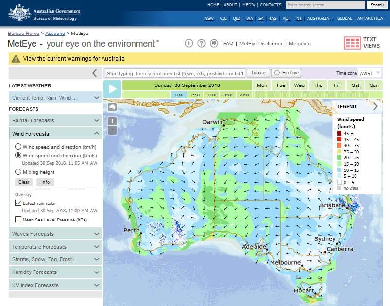
MetEye
Another BoM product of relevance to mariners is the MetEye service
(http://www.bom.gov.au/australia/meteye/). MetEye provides graphical forecast information on:
Wind (in knots)
Waves
Temperature
Storms, fog
Rainfall
UV
MetEye has national coverage including the coastal waters areas, and has the capacity for users to
zoom into discrete areas on land or sea. Each forecast cell on the map is 6 km square, and
forecasts are updated twice daily. The MetEye coverage map is shown below in Figure 21, as are
screen shots of various MetEye overlays (Figs. 21 to 24).
MetEye has additional capacities which include, inter alia, the ability to zoom in to small regions in
the view, to click on any point and get wind and wave information, or to search using map
coordinates.
19Figure 21. MetEye Coverage Map
Figure 22. MetEye Forecast by Location (user defined)
20Figure 23. MetEye Wind Speed and Direction Forecast by Location (user defined)
Figure 24. MetEye Total Wave Height Forecast by Location (user defined)
21Weather Apps
There are a number of free, or subscription based weather apps2, which can be used on a
computer, mobile phone or tablet. Weather apps typically draw data from a number of sources
(including the BoM) and combine them often presenting the graphic output in a more commercial,
or user friendly manner. Figure 25 shows data sets for the same time and location sourced from
the BoM and a weather app.
Figure 25. Rain Radar Comparison: BoM (L) and a Generic Weather App (R)
Weather apps are frequently reviewed in technology magazines and online forums. It is not
unusual for weather apps with Australian coverage with better independent reviews to have
sourced some of their data from the BoM. This is typically referenced in the app itself. It is
important that mariners using weather apps to inform their voyage consider the source of the data.
The BoM has its own weather app which can be seen at http://www.bom.gov.au/app/.
Weather apps may also source data from services such as the National Oceans and Atmospheric
Administration (NOAA) in the US, and other national weather agencies. This allows them to have
significantly more international coverage accessible from the one electronic portal.
While such apps have the ability to provide more global coverage at a single access point, they do
not appear to provide additional analysis of the data they receive and show. That is, a weather
app may make the information more accessible but it typically offers no higher resolution in
forecast, and no higher accuracy.
2 A number of weather apps were reviewed as part of this project. A decision was made not to name these
because it is not possible to review all available products, and it is not the intention of this report to
recommend one over the other, or over the services provided by the BoM.
22You can also read