Hassocks
Neighbourhood Plan

   Submission Plan

         June 2019
←
→
Page content transcription
If your browser does not render page correctly, please read the page content below

Hassocks
Neighbourhood Plan
Submission Plan
June 2019
Page Left Intentionally Blank

Hassocks Neighbourhood Plan, Revision 8, date: June 2019
Revision 8 for Submission Consultation
Contents                                                                                 Page

Foreword                                                                                    (i)

1.      Introduction                                                                         2

2.      Parish Profile                                                                       8

3.      Vision and Objectives                                                               15

4.      Environment and Heritage                                                            18

                   Policy 1: Local Gaps                                                     18
                   Policy 2: Local Green Spaces                                             21
                   Policy 3: Green Infrastructure                                           22
                   Policy 4: Managing Surface Water                                         23
                   Policy 5: Enabling Zero Carbon                                           25
                   Policy 6: Development Proposals Affecting the South Downs National Park 26
                   Policy 7: Development in Conservation Areas                              27
                   Policy 8: Air Quality Management                                         29
                   Policy 9: Character and Design                                           31
5.      Community Infrastructure                                                            34

                   Policy 10: Protection of Open Space                                      34
                   Policy 11: Outdoor Play Space                                            36
                   Policy 12: Community Facilities                                          37
                   Aim 1: Assets of Community Value                                         38
                   Policy 13: Education Provision                                           39
                   Aim 2: Education Facilities                                              39
                   Aim 3: Healthcare Facilities                                             40
6.      Housing                                                                             42

                   Policy 14: Residential Development Within and Adjoining the Built-Up Area
                   Boundary of Hassocks                                                      44
                   Policy 15: Hassocks Golf Club                                            45
                   Policy 16: Land to the North of Clayton Mills and Mackie Avenue          47
                   Aim 4: Housing Mix                                                       49
                   Policy 17: Affordable Housing                                            50
7.      Economy                                                                             53

                   Policy 18: Village Centre                                                53
                   Policy 19: Tourism                                                       54

 Neighbourhood Plan - Submission Version
8.      Transport                                     57

                   Aim 5: Non-Car Route Ways          57
                   Aim 6: Public Transport            59
                   Aim 7: Traffic and Accessibility   60
9.      Implementation and Delivery                   63

10.     Proposals Map                                 65

11.     Evidence Base                                 67

 Neighbourhood Plan - Submission Version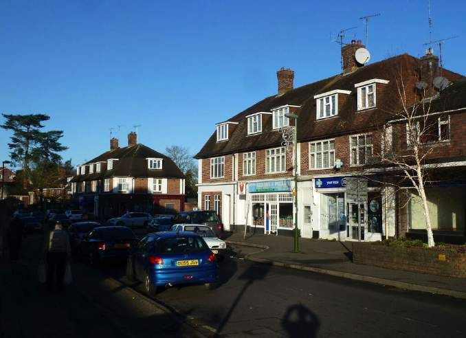
FOREWORD

This Amended Version of the Hassocks Neighbourhood Plan has been prepared by Hassocks
Parish Council following the refusal of Mid Sussex District Council (MSDC), the Local Planning
Authority, for those areas of Hassocks Parish outside the South Downs National Park to allow the
original 2016 Neighbourhood Plan to proceed to Public Examination. The reason for this was that
following the Government Inspectors instruction to MSDC to increase the supply of housing across
Mid Sussex in February 2017, our Plan made insufficient provision for new homes in Hassocks
Parish.

This decision presented the Parish Council with a choice. Either abandon the Neighbourhood Plan
altogether, or prepare a new one which complied with the housing requirement of the new District
Plan which was finally adopted by MSDC in March 2018.

The Parish Council concluded that, in spite of this set back, and the fact that we would need to at
least double the amount of new housing to meet the District Plan figure for Hassocks, we should
prepare a new Plan for the following reasons:-

    •   The District Plan is a legally binding document. Hassocks and all other town and parish
        councils in the District will have to comply with its housing requirements.

    •   Once adopted, a Neighbourhood Plan becomes a Development Plan Document which gives
        protection against further development.

    •   If we have no Neighbourhood Plan we will be more susceptible to pressure from unwanted
        development and have less ability to shape and control our future and protect our
        environment.

    •   If we have no Neighbourhood Plan we will benefit much less from the substantial
        infrastructure contributions arising from the Government’s Community Infrastructure Levy
        when this is introduced in Mid Sussex.

In light of the above, this Plan, which has been prepared by the Parish Council and co-opted
members of the community, sets out a vision for our Parish from 2014 (which is the technical start
date we must use) until 2031 (which is the end date of the District Plan).

The aims of the Plan are to:

    •   Provide a framework for future development in the Parish;

    •   Protect and enhance existing open spaces;

    •   Harness development value to improve infrastructure; and

    •   Establish Hassocks as an exemplar of high quality design and sustainable development.

 Neighbourhood Plan - Submission Version                                                    Page (i)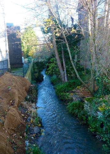
This Amended Plan takes full account of the higher housing requirement for Hassocks set out in the
District Plan. In this regard you will notice that the Strategic Site for 500 new homes on the Land
North of Clayton Mills, which caused such controversy, has been included in our Plan.

The reason for this is that it is a District Plan Strategic Allocation included in the District Plan on the
instruction of the Government Inspector. As mentioned above, the District Plan is a legally binding
document so this site must be accepted. The addition of this site means that, taken with the other
sites which already have planning permission, such as Ham Fields and the Hassocks Golf Club, we
can fully meet the District Plan Housing Requirement for Hassocks.

There is no need to allocate any more land for residential development in the Plan Period.

This Plan is now issued for public consultation. Please let us have your views.

Councillor Bill Hatton
Chairman, Neighbourhood Plan Working Group

 Neighbourhood Plan - Submission Version                                                          Page (ii)

Chapter 1
                                          Introduction

Neighbourhood Plan - Submission Version
                                                    Page 1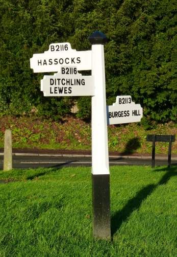
1. INTRODUCTION
1.1. The Hassocks Neighbourhood Plan (HNP) has been prepared by Hassocks Parish Council
(HPC). The HNP will guide and influence development in the Parish up to 2031. It covers the
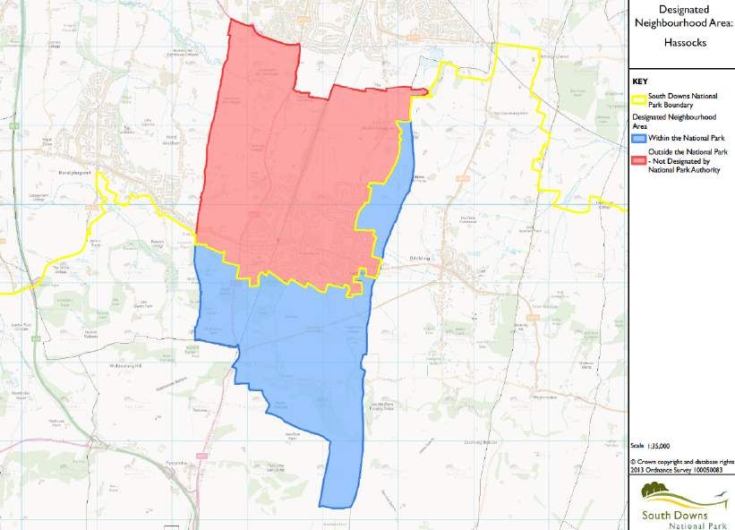
whole of the Parish, including Keymer and Clayton, as shown in Figure 1.
Figure 1 - Hassocks
Designated Area
1.2. The southern and eastern boundary of the Parish lies in the South Downs National Park
(SDNP).The extent of the SDNP is shown at Figure 2. South Downs National Park Authority
is the Local Planning Authority for those areas of the Parish within the South Downs National
Park.
1.3. Mid Sussex District Council (MSDC) designated the Parish for the purposes of
neighbourhood planning on the 16 July 2012. Given part of the Parish lies within the SDNP,
the South Downs National Park Authority (SDNPA) also designated the Parish in September
2012.
Neighbourhood Plan - Submission Version
Page 2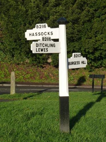
Figure 2 - Extent of SDNP.

1.4.     The preparation of the HNP commenced thereafter with the formation of the
         Neighbourhood Plan Working Group (NPWG).

1.5.     The Regulation 14 Pre-submission HNP and accompanying SA were submitted to MSDC
         in June 2016. Regulation 16 consultation followed between July-September 2016.
         However, the Submission HNP was not progressed to Examination. In light of feedback
         from the ongoing examination of the Mid Sussex District Plan (MSDP), in particular with
         respect to the overall level of housing need, MSDC determined that the Submission HNP
         should not proceed to Examination. Progress of the HNP was paused, pending the final
         adoption of the MSDP, which occurred in March 2018.

1.6.     Following this, and in light of a meeting with MSDC Officers, the NPWG met on the 27
         June 2018 to discuss the HNP and future options. It was agreed the NPWG would
         progress a ‘light touch’ review of the HNP.1

1.7.     This Submission Plan has been prepared following extensive background work, publication
         and consultation on the Regulation 14 Pre-submission HNP.

1 See minutes of NPWG meeting on 27 June 2018

 Neighbourhood Plan - Submission Version
                                                                                           Page 3
Planning Context

1.8.     The Localism Act 2011 introduced new rights and powers to allow local communities to
         shape new development by preparing neighbourhood plans. A neighbourhood plan
         establishes planning policies for the development and use of land, for example where new
         homes should be built and what they should look like. Neighbourhood plans allow local
         people to influence the type of development for their area while contributing to the wider
         needs of the area.

1.9.     The Government published the revised National Planning Policy Framework (NPPF) in
         February 2019. This sets out the Government’s planning policies for England and how
         these should be applied. It provides a framework within which locally-prepared plans for
         housing and other development can be produced.

1.10.    With respect to neighbourhood planning, the NPPF advises:

               “Neighbourhood planning gives communities the power to develop a shared vision for
               their area. Neighbourhood plans can shape, direct and help to deliver sustainable
               development, by influencing local planning decisions as part of the statutory
               development plan. Neighbourhood plans should not promote less development than set
               out in the strategic policies for the area, or undermine those strategic policies.” 2

1.11.    Neighbourhood plans must be in general conformity with the adopted Development Plan
         Document.3 For those parts of the Parish which fall within Mid Sussex District planning
         boundary, the most recently adopted Development Plan is the MSDP 2014-2031.4 This was
         adopted by MSDC on the 28 March 2018.

1.12.    For those parts of the Parish which fall within the SDNP, the adopted Development Plan is
         the Mid Sussex Local Plan 2003.

1.13.    The SDNPA is preparing a Park-wide South Downs Local Plan (SDLP). The SDLP was
         submitted to Government in April 2017. The Examination of the SDLP is ongoing. The
         Inspector’s Report is awaited. Once adopted, the SDLP will replace the existing planning
         policies operating across the SDNP.

2 Paragraph 29 of the National Planning Policy Framework

3 Paragraph 37 of the National Planning Policy Framework

4 Small Scale Housing Allocations Document forms part of the Development Plan

 Neighbourhood Plan - Submission Version
                                                                                             Page 4
Plan Preparation
1.14. This HNP reflects the culmination of work by the NPWG since the Parish was designated for
neighbourhood plan making in July 2012. It builds upon the evidence gathering, stakeholder
engagement and plan preparation that took place in formulating the initial version of the
HNP that was the subject of statutory consultation in 2016.
1.15. Since HPC resolved to progress with a revised HNP in June 2018, the NPWG have
undertaken a detailed review and update of the evidence base. Integral to this approach has
been a review and update of the Vision and Strategic Objectives of the Submission HNP.
1.16. In addition, a review has been undertaken of the planning policies and aims. This has been
informed by new and revised background papers on Housing; Policy 1: Local Gaps; Policy
2: Local Green Spaces.
1.17. Public consultation on the Regulation 14 Pre-Submission took place between January-
February 2019. Following a review of representations received, the Submission HNP has
been prepared. It has been prepared in accordance with the Neighbourhood Planning
(General) Regulations 2012 and is in “general conformity” with the strategic policies of the
MSDP.
1.18. In addition, a review has been undertaken of the planning policies and aims. This has been
informed by new and revised Background Papers on: Housing; Policy 1: Local Gaps; and
Policy 2: Local Green Spaces have also been updated.
Plan Structure
1.19. The HNP sets out:
• Chapter 2: Description of the Parish;
• Chapter 3: HNP’s Vision and the Strategic Objectives for the area up to 2031;
• Chapter 4: Environment and Heritage;
• Chapter 5: Community Facilities;
• Chapter 6: Housing;
• Chapter 7: Economy; and
• Chapter 8: Transport.
Neighbourhood Plan - Submission Version
Page 51.20. Stakeholder and residents have previously expressed support for improvements to
community facilities and transport infrastructure.5 Where issues are outside the remit of the
HNP these have been included as Aims to support the aspirations of the local community.
Consultation
1.21. This Submission HNP and the accompanying documents (Sustainability Appraisal including
Non-Technical Summary, Basic Condition Statement and Consultation Statement) have
been approved by HPC for submission to MSDC.
1.22. Following a period of public consultation, the Submission HNP will be subject to
Examination. Subject to receipt of a positive Examiner’s Report, the HNP will then proceed
to Referendum and be “made” in due course by MSDC.
5 Public consultation events held during 2014-2015
Neighbourhood Plan - Submission Version
Page 6Chapter 2
Parish Profile
Neighbourhood Plan - Submission Version
Page 7
Page 72. PARISH PROFILE
2.1. Hassocks Parish is located
south of Burgess Hill, east of
Hurstpierpoint and west of
Ditchling. To the south of the
main built-up area of Hassocks
and Keymer village is the
SDNP, beyond which is the
urban area of Brighton.
2.2. It is a Parish of high landscape
and townscape quality. It
includes the steep chalk scarp
Figure 3 - Hassocks and Keymer
slopes of the South Downs that
gives way to the low weald to
the north. In total, the Parish extends to some 10.88kms2 (4.20sq miles).
2.3. At its centre is the built-up area of Hassocks and Keymer, whilst to the south is the hamlet
of Clayton. The main built-up area is separated from Hurstpierpoint in the west, Ditchling in
the east, and Burgess Hill to the north by narrow, but important, rural hinterland ‘gaps’ of
generally undeveloped land.
2.4. The main access routes through the Parish are the east-west B2116 and the north-south
A273. The London to Brighton railway line also runs through the Parish north-south, with a
station serving the local community.
Environment and Heritage
2.5. The countryside character of the Parish is dominated by the north-facing steep chalk scarp
slopes of the South Downs. These are on the southern edge of the Parish, contained south
of Underhill Lane. They include an important area of species rich chalk grassland, that is
recognised by its designation as part of a Site of Special Scientific Interest (SSSI).
2.6. To the north of this is the scarp footslopes. These run from Underhill Lane, north to the
southern edge of the built-up area of Hassocks and Keymer. The character area is defined
by its undulating, low sandstone ridges and gentle clay vales. There are areas of ancient
woodland, predominantly either side of the A273 and railway line to the south of the main
built-up area (e.g. Butchers Wood).
Neighbourhood Plan - Submission Version
Page 82.7. The northern area of the Parish comprise part of the low weald. This is predominantly a
lowland mixed arable and pastoral landscape with low ridges and clay vales.
2.8. The watercourses of the Parish typically drain north, and comprise part of the Upper Adur
streams. This includes the Herring Stream which runs through the built-up area of Hassocks
(see Figure 4). Parts of the periphery of the stream are defined as being at risk of flooding at
a greater incidence than a 1 in 100 year event.
2.9. There is a Scheduled Ancient Monument within the
Parish, comprising 4 bowl barrows, some 800m
south of New Barn Farm. These are funerary
monuments dating from the late Neolithic period to
late Bronze Age.
2.10. Evidence of Roman habitation of the Parish has also
been found. The area may have been a crossroads
between routes running north-south and east-west,
the latter along the low sandstone ridge.
2.11. There is also evidence of medieval occupation of the
area, perhaps most notably, the Grade I Listed St
John the Baptist Church at Clayton. This dates from
the 11th Century and contains important frescoes.
Figure 4 - Herring Stream
2.12. There are 3 Grade II* Listed Buildings within the
Parish, namely Ockley Manor, Clayton Windmills and the attached Millhouse, and Clayton
Priory. There are a further 22 Grade II Listed Buildings.
2.13. The Parish has two Conservation Areas; the historic core of Keymer, focussed around
Keymer Road, The Crescent and Lodge Lane; and the historic core of Clayton, focussed
around Underhill Lane.
Community Infrastructure
2.14. The community facilities of the Parish are predominantly focussed within the built-up area of
Hassocks and Keymer.
2.15. State education provision is contained with 3 schools; Hassocks Infants, The Windmills
Junior and Downlands Community School (Secondary).
Neighbourhood Plan - Submission Version
Page 92.16. There is a health-centre in Windmill Avenue, and this is operated as part of a group of 3
health centres that also incorporates those in Hurstpierpoint and Ditchling.
2.17. The Hassocks Public Library is located on
Keymer Road and is operated by West
Sussex County Council.
2.18. Recreation and public open space is
provided throughout the Parish. It
includes Adastra Park within the centre of
the built-up area, and comprises playing
fields, tennis courts, pavilion, children’s
equipped play space, and a public hall
Figure 5 - Adastra Park
with seating for 240 people. On the
north-west periphery of the village is
Belmont Recreation Ground, to the west is Talbot Field, and to the south is Clayton
Recreation Ground. These provide a mix of sports pitches, associated pavilion, and/or
informal open space.
2.19. There are a number of private sports clubs and facilities, and these include the Weald Lawn
Tennis and Squash Racquets Club on South Bank, and Hassocks Football Club on the east
side of Brighton Road. Informal open space and an equipped play space has more recently
also been provided at the northern edge of Hassocks, in conjunction with the development
known as Clayton Mills.
Housing
2.20. Much of the development of the Parish occurred as a result of, and following, construction
of the London to Brighton railway line in the 1840s. This was typified by the construction of
Victorian terraced houses, semi-detached houses and larger detached villas. More recently,
the periphery of Hassocks and Keymer has been expanded by more modern housing
development on land north of the built up-area boundary at Clayton Mills and to the west of
the built-up area boundary along London Road.
2.21. The latest Census data shows that the total population of the Parish as at 2011, was 7,667
persons (an increase of 846 (12.4%) from the Census of 2001). The population comprised
20% aged 0-17; 27% aged 18-44; 27% aged 45-64; and 26% aged 65 and over.
Neighbourhood Plan - Submission Version
Page 102.22. The Census data from 2011 reveals there were 3,342 households, providing an average
household size of 2.28 persons. This was an increase in the average household size from
the 2001 Census data from 2.21 persons.
2.23. More recently a number of planning permissions have been granted in the Parish. These
include Stafford House;6 Hassocks Golf Club;7 and land west of London Road.8
2.24. In addition, the Parish is set to experience significant growth with the delivery of the
strategic allocation on land to the north of Clayton Mills. MSDP - Policy DP11, the site for
strategic development for 500 new homes.
Economy
2.25. Census data from 2011 indicates
that some 82.1% of Parish
residents aged between 16-64
are ‘economically’ active of which
most are in employment. Almost
two-thirds of the workforce are
‘white-collar’ workers, of which
almost a quarter are in
‘professional’ jobs. This is higher
than both the rest of the District,
and nationally. Some 41%9 have
Figure 6 - Keymer Road, Hassocks.
a degree level or higher
qualification, compared with 30%
in the country as a whole. Conversely, 7% have no qualifications compared to 15% in the
country as a whole.
2.26. Some 15% of the workforce are self-employed and some 14% work from home. Of those
that travel to work, only 9% work within 2km of home, which compares to 17% in the wider
District. A total of 11% travel more than 60km to work, compared to 4% in the wider
District.
6 DM/15/3309
7 DM/16/1775 / DM/18/2616
8 13/03818/OUT / DM/15/0266 / DM/17/4307
9 2011 Economically active persons
Neighbourhood Plan - Submission Version
Page 112.27. This data gives a picture of a relatively highly skilled workforce, many of whom either work
from home or commute significant distances to work. This reflects the relative absence of
industrial and employment floorspace in the Parish, and its relative accessibility by train to
higher tier centres such as London.
2.28. According to the 2015 District Council non-domestic rates record there are 170 business
premises in the Parish. Of this, 48 are shops. Many of these are independent retailers.
Collectively these provide a range of retail and business services. Retail and associated high
street uses (financial services, cafes etc) are typically clustered along Keymer Road, to the
east of the railway line. The main exception to this is the Garden Centre on Brighton Road,
south of the Stonepound Crossroads.
2.29. There is a cluster of commercial premises within ‘Hassocks Goods Yard’ immediately south
of Keymer Road and west of the railway line, and at Broadhill Craft Workshops, to the north
of the main built-up area and east of Ockley Lane. There is no major industrial estate within
the Parish.
2.30. Despite its proximity and accessibility to the SDNP, the Parish has a relatively limited level of
tourism facilities. There is 1 camp site and 3 self-catering holiday lets within the Parish.
Transport
2.31. The Parish is located to the east of the A23 and
north of the A27. Within the Parish the principal
roads are the A273 which runs north-south, on the
western periphery of the main built-up area, and
the B2116 which runs east-west, through the
centre of the main built-up area, and connects to
Ditchling and Hurstpierpoint. The B2112 also runs
east-west connecting Ditchling to Clayton, to the
south of the main built-up area.
2.32. The intersection of the A273 with the B2116,
known as Stonepound Crossroads, is a phased,
traffic light junction. As a result of the volume of
traffic at this crossroads, the local environment
around the junction experiences high levels of
nitrogen dioxide. This resulted in the area being Figure 7 - Village signpost
designated as an Air Quality Management Area
(AQMA) in March 2012. An Action Plan was
approved in 2013 to reduce levels of pollution below target levels. This principally seeks to
change the phased light sequencing, minimise HGV movements in the area through
Neighbourhood Plan - Submission Version
Page 12advisory alternative route signage, and encourage stationary motorists to turn-off engines,
again through signage.
2.33. The Parish is served by the London to Brighton railway line which runs north-south, with a
station located within the centre of Hassocks village. There are typically 3 trains per hour in
each direction during the day. The station serves a rural hinterland and as a result, there is
extensive commuter parking in and around the vicinity of the station.
2.34. There is a limited number of bus routes that serve the Parish. The majority operate along the
A273, with a relatively limited service within and around the main built up area. The main
routes operate on an hourly basis during the day.
2.35. There is an extensive Public Rights of Way (PRoW) network within the Parish, and this
includes access to, and within, the SDNP. These are used by walkers, cyclists and horse-
riders.
Neighbourhood Plan - Submission Version
Page 13Chapter 3
Vision and Objectives
Neighbourhood Plan - Submission Version
Page 143. VISION AND OBJECTIVES
Introduction
3.1. As part of the preparation of the revised HNP, the NPWG reviewed the Vision and Strategic
Objectives as contained in the previous version of the HNP. It was considered that both
should be amended to reflect the current aspirations of the Parish.
3.2. Set out below is the updated Vision and set of Strategic Objectives.
Vision:
To ensure Hassocks, Keymer and Clayton continue to develop sustainably as a
vibrant Parish within a countryside setting.
To provide access for the whole community to local social, cultural, sporting and
environmental amenities.
To ensure the Parish retains its rural feel and remains a desirable place to live,
work and visit. Changes that occur should protect and enhance the existing
character of the Parish.
Strategic Objectives:
1. To preserve and enhance the rural character and biodiversity of the Parish and
its historic buildings, maintaining gaps to neighbouring towns and villages, and
having regard to the relationship of the Parish within, and part of the setting to
the South Downs National Park.
2. To ensure all sections of the community have access to key local services
including education, health, community services, sporting, cultural, religious,
performing and social clubs, groups and shops.
3. To provide the opportunity for appropriately sized, affordable and sustainable
housing, developed in sympathy with the village and its surroundings, built to
very high standards of design, construction, energy efficiency and water
management.
4. To encourage economic development and job creation within the built-up area
of the village.
Neighbourhood Plan - Submission Version
Page 155. To develop the centre of the village to form a distinctive social hub.
6. To promote non-car modes of travel, including through accessibility to public
transport and improvements in pedestrian and cycle safety; encouraging people
to walk, cycle and ride in and around the Parish; to reduce the impact of traffic
in terms of congestion, pollution, parking and vehicle speeds; and to encourage
the use and availability of electric vehicles.
7. To ensure the whole Parish is safe, accessible and attractive to all, acting as a
gateway to the South Downs National Park, encouraging tourism, and
supporting healthy lifestyles and wellbeing.
Neighbourhood Plan - Submission Version
Page 16Chapter 4
Environment and
Heritage
Neighbourhood Plan - Submission Version
Page 17
Page 174. ENVIRONMENT AND HERITAGE
Strategic Objective:
To preserve and enhance the rural character and biodiversity of the Parish and its
historic buildings, maintaining gaps to neighbouring towns and villages, and
having regard to the relationship of the Parish within, and part of the setting to the
South Downs National Park.
Introduction
4.1. The Parish benefits from a rich and varied environment. This includes the scarp slopes of
the south downs in the south, merging with the low weald in the north. The main built-up
area of the Parish is located broadly centrally within its hinterland.
4.2. Immediately beyond the
Parish boundaries are the
settlements of Burgess Hill,
Hurstpierpoint and Ditchling.
4.3. The Parish benefits from a
range of heritage assets and
areas of townscape quality,
including areas of open
space within the built-up
area.
Figure 8 - Land to the east of Ockley Lane
4.4. These individually and
collectively positively contribute to the character of the Parish. It is important that the
environment and heritage assets of the Parish are protected over the HNP period.
Policy 1: Local Gaps
4.5. The main built-up area of Hassocks and Keymer is separated from Burgess Hill to the north
and from Ditchling to the east and from Hurstpierpoint to the west by generally undeveloped
land.
4.6. The importance of the separation of these settlements has previously been acknowledged in
the adopted Mid Sussex Local Plan through the identification and designation of Strategic
and Local Gaps.
Neighbourhood Plan - Submission Version
Page 184.7. The MSDP acknowledges the settlement pattern of the District makes an important
contribution to the distinctive character of Mid Sussex. The Strategic Objectives of the
MSDP seek “to promote well located and designed development that reflects the District’s
distinctive towns and villages, retains their separate identity and character and prevents
coalescence.”
4.8. In order to achieve the Strategic Objectives of the MSDP, Policy 13: Preventing Coalescence
of the MSDP, sets out a framework to prevent coalescence between settlements.
Furthermore, it confirms the importance that the separate identity of settlements is
maintained and people have a sense of having left one settlement before arriving in the next.
4.9. The Policy sets out support for the identification of Local Gaps in Neighbourhood Plans. It
does not however identify specific areas for protection. In order for Local Gaps to be
identified, MSDC require “robust evidence that development within the gap would
individually or cumulatively result in coalescence and the loss of the separate identity and
amenity of nearby settlements”. Furthermore, the policy requires that it must be
demonstrated that existing local and national policies cannot provide the necessary
protection to these areas.
4.10. In light of the requirements of the MSDP, the HNP is underpinned by a background paper10
which reviews Policy 1 and Policy 2 of the Submission HNP (2016) against the requirements
of MSDP DP13: Preventing Coalescence, specifically to assess whether there is a need for a
gap policy in the HNP.
4.11. In reviewing whether there is a need for a gap, the background paper has taken account of
changes to planning policy, both locally and nationally, and also had regard to planning
decisions for proposals on land within the previously proposed gap areas. These include
approval for up to 97 homes on land to the west of London Road11 and refusal on appeal
for 130 homes on land at Friars Oak.
4.12. The proposed development of 97 homes on land west of London Road was the subject of a
complex planning appeal process. Ultimately, planning permission was granted in March
2017,12 by the Secretary of State, having regard to, and following, a Public Inquiry in August
2016. Although planning permission was granted, the appointed Inspector acknowledged
that the gap between Hurstpierpoint and Hassocks serves an important planning function in
preventing the coalescence of the two settlements, and maintaining their separate identities
and amenities, and this is in accordance with the NPPF. The Inspector concluded that with
appropriate mitigation, the purpose of the gap and its character would not be unduly
10 Revised Hassocks Neighbourhood Plan Local Green Space Policy Review, October 2018
11 APP/D3830/W/14/2226987
12 APP/D3830/W/14/2226987
Neighbourhood Plan - Submission Version
Page 19undermined by the proposed development13. The mitigation referred to by the Inspector
included the retained and new planting in the outer open space of the site, to enable the
delivery of a softer edge to this part of the settlement than currently exists.14
4.13. As part of the preparation of the background paper, a Landscape and Visual Assessment
has been undertaken. This demonstrates that:
• The land within the respective gaps retains a strong rural character which reflects key
characteristics as described in the HNP Landscape Character Assessment; and
• The land within the respective gaps is of importance in maintaining the setting and
identity of the individual settlements.
4.14. In light of the above, the HNP proposes a local gap policy within the revised HNP. The policy
seeks to protect the area to the north of the main built-up area of Hassocks and Keymer
and areas to the east and west of the main built-up area of Hassocks, as defined on the
Proposals Map. These areas are considered important and the HNP seeks to keep these
areas free from development in the long-term in order to secure the objectives of the Local
Gap. Where there are buildings, or groups of buildings, within the Local Gap, these will be
treated as part of the Local Gap.
Policy 1: Local Gap
Local Gaps have been defined and will be safeguarded between:
a. Keymer/Hassocks and Ditchling;
b. Keymer/Hassocks and Hurstpierpoint; and
c. Keymer/Hassocks and Burgess Hill.
as defined on the Proposals Map with the objectives of preventing coalescence
and retaining the separate identity and amenity of settlements.
Development will be supported within the Local Gap where:
1. It is necessary for the purposes of agriculture, or some other use which has to
be located in the countryside; or
2. It is a scheme for housing that is in accordance with MSDP Policy DP6 (1-3) and
includes an appropriate landscape buffer to strengthen the purposes of the
13See Paragraph 211 of APP/D3830/W/14/2226987
14 See Paragraph 207 of APP/D3830/W/14/2226987
Neighbourhood Plan - Submission Version
Page 20Local Gap; and
it would not compromise individually or cumulatively the objectives and
fundamental integrity of the gaps between Hassocks and the settlements of
Ditchling, Hurstpierpoint, and Burgess Hill.
Policy 2: Local Green Spaces
4.15. The NPPF enables the designation of land as Local Green Space (LGS) through local and
neighbourhood plans.
4.16. Paragraph 99 of the NPPF allows communities to identify and protect green areas of
particular importance to them. The NPPF notes LGS’s should only be used where the green
space is:
• in reasonably close proximity to the community it serves;
• demonstrably special to a local community and holds a particular local significance,
for example because of its beauty, historic significance, recreational value (including
as a playing field), tranquility, or richness of its wildlife; and
• local in character and not an extensive tract of land.15
4.17. Having regard to these criteria, it is considered that there are a number of green spaces
both within, and around, the built-up areas of the Parish that warrant protection.
4.18. The HNP/Policy is supported by a background paper16 which sets out and demonstrates
how the identified areas meet the requirements of the NPPF. This paper was originally
prepared to support the Submission Version HNP (June 2016). It has been updated to take
account of changes to national planning policy and to reconsider whether all, or part of the
previously proposed LGS sites meet the criteria of the NPPF. In addition to consideration of
previous LGS’s proposed, the background paper also assesses an additional location to be
protected.
4.19. The background paper includes a traffic light assessment to provide an overview of whether
each site fully, partially, or does not meet the requirements of the NPPF. This concluded all
of the sites assessed, wholly or predominantly, meet the NPPF criteria and are therefore
proposed as LGS in the HNP. These areas are defined on the accompanying Proposals
Map. Within such areas the HNP seeks to protect these green areas from development.
15 Paragraph 100 of the NPPF
16 Revised Hassocks Neighbourhood Plan, Local Green Space Policy Review, October 2018
Neighbourhood Plan - Submission Version
Page 214.20. The purpose of the proposed designations are to provide special protection against the
inappropriate development of areas of particular local importance as green space. Where
the LGS benefits from an existing public access and/or recreational use, designation as an
LGS would not prohibit the use of that LGS for future public access and/or recreational
uses.
Policy 2: Local Green Spaces
The Hassocks Neighbourhood Plan designates the following locations as Local
Green Spaces (as shown on the Proposals Map):
1. Land to the north of Shepherds Walk (LGS1).
2. Land at the Ham (LGS2).
3. Land to the south of Clayton Mills (LGS3).
4. Land to the east of Ockley Lane (LGS4).
5. Land at south of Downlands (LGS5).
6. Land to the west of the railway line (LGS6).
7. Land at Pheasant Field (LGS7).
8. Land at Clayton Mills (LGS8).
Development proposals, which conflict with the purpose of this designation, will
be resisted in these areas.
Policy 3: Green Infrastructure
4.21. The NPPF defines ‘green infrastructure’ as a “network of multi-functional green space, urban
and rural, which is capable of delivering a wide range of environmental quality of life benefits
for local communities.”17
4.22. Within the Parish, green infrastructure includes woodland and hedges, parks and open
spaces, recreational space (e.g. golf course), watercourses, PRoW, allotments, tree lined
streets and aged or veteran trees.18 It also includes an important area of species rich chalk
grassland that is recognised and protected by its designation as part of an SSSI.
4.23. The benefits that result from this green infrastructure include an enhancement in the visual
appearance of the area, provide access for residents to sport, recreation and quiet
17 See Annex 2 of the NPPF
18 See definition in Annex 2 of the NPPF
Neighbourhood Plan - Submission Version
Page 22enjoyment, connected networks for wildlife, help to reduce flood risk, facilitate non-car
modes of travel, and provide allotments. Well managed green infrastructure contributes to
wider economic and social benefits, improved physical and mental health outcomes,
economic competitiveness and greater attraction to tourists.
4.24. The HNP seeks to both conserve and enhance existing green infrastructure assets, and
ensure new development contributes to the enhancement of this network.
Policy 3: Green Infrastructure
Development proposals, which seek to conserve, maintain or enhance the existing
green infrastructure network will be supported.
Where proposals include the provision of additional green infrastructure these will
be supported where:
1. They seek to link to the existing path and open space networks;
2. They provide off road access for walking, cycling and horse-riding;
3. Planting contributes to wildlife and links to existing woodland, hedges and
streams; and
4. Proposals include the planting of native species.
Proposals, which would result in the loss of existing green infrastructure, will be
resisted unless it can be demonstrated that the development proposals brings
new opportunities which mitigates or compensates any loss whilst ensuring the
protection of the existing ecosystem.
Policy 4: Managing Surface Water
4.25. The NPPF advises the planning system should support the transition to a low carbon future
in a changing climate, taking full account of flood risk and coastal change.19
4.26. The Flood and Water Management Action 2010 requires County Councils to lead the
coordination of flood risk. In light of this, West Sussex County Council (WSCC) have
prepared the West Sussex Local Flood Risk Management Strategy. This sets out how
WSCC carries out its flood risk responsibilities and outlines a strategy to define how local
flood risk will be managed in the county.
19 Paragraph 148 of the NPPF
Neighbourhood Plan - Submission Version
Page 234.27. With respect to Mid Sussex, the Strategy confirms the District contains six areas that are at
risk of flooding. These are Burgess Hill, Copthorne, Hassocks, Haywards Heath and
Lindfield, East Grinstead, and Sayers Common.
4.28. The Strategy confirms, that properties in Hassocks are largely at risk from surface water
flooding. It identifies a number of ‘wet spots’ and the number of residential properties and
businesses susceptible to flood risk by flood source. A total of 685 residential properties
and businesses in Hassocks are susceptible to flood risk. Of these, 525 properties are
identified as at risk of surface water flooding; 105 are identified as at risk of river flooding;
and 55 are at risk of flooding from a combination of both surface water and river flooding.20
4.29. Given the local flood risk issues, the Hassocks, Hurstpierpoint, Keymer and Ditchling
Transition (HKD) group commissioned a project to gain a better understanding of flood risk
in the local area. This work was funded by West Sussex County Council’s Operation
Watershed fund.
4.30. The aim of the project was to:
• Digitally map areas for potential green infrastructure (GI) interventions in Hassocks;
• To engage with the public of Hassocks to map areas of where surface flooding and river
flooding have historically happened in the town;
• To map areas of where surface water flooding is a current concern;
• Assess the potential impact of the GI interventions in Hassocks;
• To work with the public to identify areas where GI could be installed in the village of
Hassocks;
• To engage the public and promote GI to the wider public in Hassocks and beyond; and
• To create one GI intervention in the town in 2017.
4.31. The Report21 highlights measures which could be designed into the townscape to help
manage local flood risk.
4.32. The HNP wishes to support the implementation of local measures and initiatives to ensure
flood risk is managed appropriately.
20 West Sussex Local Flood Risk Management Strategy, Figure 6
21 Hassocks Green Infrastructure Project, Community and Neighbourhood Sustainable Urban Drainage Report, June 2017
Neighbourhood Plan - Submission Version
Page 24Policy 4: Managing Surface Water
Development proposals which seek to reduce the risk of surface water flooding
will be supported. Development proposals should seek to reduce existing run-off
rates in the first instance.
Development proposals which incorporate sustainable drainage techniques to
manage surface water will be supported. Where technically feasible sustainable
drainage techniques should include infiltration measures that reflect natural
drainage patterns and manage water as close to its source as possible.
Policy 5: Enabling Zero Carbon
4.33. Global heating is a world-wide threat that requires concerted action to minimise its adverse
effects.
4.34. The Mid Sussex District Council Sustainability Strategy 2018-2023 sets out MSDC’s
approach to sustainability and delivering sustainable development. This is supported by a
Sustainability Action Plan to help co-ordinate and structure sustainability actions and ensure
they are implemented in a meaningful and pragmatic way.
4.35. The Sustainability Action Plan aims to:
• Embed sustainability in all corporate actions;
• Support communities in implementing sustainable actions and becoming more
resilient to a changing climate; and
• Support businesses in achieving savings through energy efficiency and other
sustainability initiatives.
4.36. The HNP supports the aims of the Sustainability Action Plan. In particular, the HNP wishes
to support proposals which seek to implement sustainable measures including those which
increase the use and supply of renewable and low carbon energy and heat. In addition, the
HNP seeks to support proposals which make provision for, and support the provision of
charging facilities for charging electric vehicles.
Neighbourhood Plan - Submission Version
Page 25Policy 5: Enabling Zero Carbon
Support will be offered for development proposals that maximise the opportunity
to include sustainable design features, providing any adverse local impacts can be
made acceptable.
All residential development proposals that modify existing buildings (including
extensions) should seek to maximise the inclusion of energy-saving measures and
renewable energy generation.
Planning applications for developments of new dwellings must be accompanied
by an Energy Assessment using the standard assessment procedure* (SAP) to
demonstrate how carbon dioxide emissions are to be minimised onsite.
All new residential development will be required to demonstrate that the net
maximum heat energy requirement of the dwelling calculated using the SAP is 15
kWh/m2/year or less**/***.
Proposals which make provision for charging electric vehicles at each dwelling
(where feasible) and on-street; and making parking areas charging ready will be
supported.
* For a definition of this process see Part L1 of the Building Regulation.
**/*** A negative value would mean the development is expected to be a net exporter of energy to the
grid or to a district heating system.
A 15 kWh/m2/year is the German Passivhaus standard. However this Policy is not saying that
Passivhaus standard should be adopted, as the UK climate is better suited to automated domestic
heating and ventilation controls that were not available when the Passivhaus standard was developed;
but it does take the Passivhaus level of heating energy efficiency as the objective standard to be
achieved.
Policy 6: Development Proposals Affecting the South Downs National Park
4.37. The South Downs was designated as a National Park in April 2011. It stretches from Lewes
in the east to Winchester in the west, and covers an area of approximately 1,627 square
kilometres. It includes the long distance footpath, the South Downs Way.
4.38. The statutory purposes for National Parks is set out in the Environment Act 1995 as:
1. To conserve and enhance the natural beauty, wildlife and cultural heritage of the area;
2. To promote opportunities for the understanding and enjoyment of the special
qualities of the national park by the public.
Neighbourhood Plan - Submission Version
Page 264.37. The southern and eastern boundary of the Parish lies in the SDNP, as identified in Figure 2.
4.38. The HNP recognises the importance of the South Downs National Park and seeks to
positively support the purposes of the Park and the duty of the Park Authority in discharging
its functions with respect to land use.
4.39. In addition, the HNP acknowledges the areas of land surrounding the SDNP makes a
positive contribution to the setting of the SDNP. The HNP therefore wishes to protect the
setting of the SDNP from inappropriate development.
Policy 6: Development Proposals Affecting the South Downs National Park
Development proposals within the South Downs National Park will be supported
where they:
1. Have regard to the purposes and duty of the Park Authority; and
2. Conserve and enhance the landscape character, scenic beauty, wildlife and
cultural heritage of the Park.
Development proposals on land outside of, but contributing to, the setting of the
South Downs National Park will be supported where proposals:
3. Do not detract from, or cause detriment to, the special qualities and tranquility
of the South Downs National Park; and
4. Do no significantly harm the South Downs National Park or its setting.
Policy 7: Development in Conservation Areas
4.40. The Parish contains two Conservation Areas. These comprise the historic core of Keymer,
and the historic core of Clayton. The Conservation Areas include a number of Listed
Buildings.
4.41. The NPPF makes clear that Conservation Areas and Listed Buildings are ‘heritage assets’
and are an irreplaceable resource that should be conserved in a manner appropriate to their
significance, so that they can be enjoyed for their contribution to the quality of life for
existing and future generations.22
22 Paragraph 184 of the NPPF
Neighbourhood Plan - Submission Version
Page 274.42. The Parish Council supports this
requirement, and recognises the
importance of heritage assets
and the contribution they make
to the quality of the area, in
terms of local character and
distinctiveness, and their
associated cultural, economic
and environmental benefits.
Figure 9 - Keymer Church
Neighbourhood Plan - Submission Version
Page 28Policy 7: Development in Conservation Areas
Development proposals which seek to preserve or enhance the Keymer
Conservation Area and Clayton Conservation Area will be supported.
The following special features have been identified in the Keymer Conservation
Area:
1. Keymer Terrace and the stone wall by the church;
2. The Church and its setting;
3. Properties in the Crescent;
4. Properties and features of Lodge Lane;
5. The Greyhound Pub;
6. The bend in Keymer Road;
7. Views into an out of the Conservation area; and
8. The use of traditional building materials.
Any development in the conservation area must preserve or enhance these features.
The following special features have been identified in the Clayton Conservation
Area:
9. The Church and its setting;
10. Former farm buildings associated with Clayton Farm;
11. Clayton Court Barn;
12. The Manor House;
13. Clayton Castle;
14. Building materials including flint, brick, hanging tiles and roof tiles;
15. Views out of the Conservation Area to the open downland, including the Jack
and Jill Windmill;
16. Rural setting with the Downs rising steeply to the south;
17. Rural character of Underhill Lane; and
18. The sense of enclosure created by the narrow sunken lane.
Any development in the conservation area must preserve or enhance these features.
Policy 8: Air Quality Management
4.43. The Parish contains a designated Air Quality Management Area located at the Stonepound
Crossroads. The AQMA was designated in March 2012 as a result of the high levels of
Neighbourhood Plan - Submission Version
Page 29nitrogen dioxide being likely to breach the Air Quality (England) Regulations 2000 (as
amended). This area includes a number of residential properties that are immediately to the
south-east of the crossroads (1-6 Overcourt; The Coach House; and Shooldarry).
4.44. The main reasons for the crossroads being affected by air pollution is the volume of road
traffic and the stop-start routine of driving conditions at peak times, caused by the queuing
traffic at the traffic lights.
4.45. In 2013 MSDC approved an Action Plan, noting that a ‘do-nothing’ option would fail to bring
about improvements in nitrogen dioxide levels. The Action Plan includes three main
measures to (i) change light sequencing to reduce stationary times; (ii) minimise HGV
movements through advisory alternative route signage; and (iii) reduce pollution from
queuing vehicles by encouraging drivers through signage to turn-off engines when
stationary. There were also a series of other measures proposed that were noted to be less
likely to have a significant impact.
4.46. HPC supports proposals which will reduce nitrogen dioxide levels within its area, and reduce
the harmful impacts on its residents.
4.47. The District Council note that for the AQMA to be revoked, annual air quality monitoring data
will need to show levels of air pollution at consistently below the target level.
4.48. HPC consider that development should not be supported where it has an unacceptable
adverse effect on the AQMA, or where a proposed use or users within the AQMA would be
unacceptably adversely effected by the air quality.
4.49. HPC do not wish to support proposals which could lead to unacceptable adverse effect
upon air quality within the AQMA, in line with European Union air quality standards.
4.50. HPC consider this position should be maintained unless, and until, the levels of air pollution
are demonstrably below the target level in the Regulations, sufficient to enable the AQMA to
be revoked.
Policy 8: Air Quality Management
Development will be supported where it would not have an unacceptable adverse
effect upon air quality within the Air Quality Management Area.
Neighbourhood Plan - Submission Version
Page 30Policy 9: Character and Design
4.51. The Parish contains a broad range of architecture styles and townscapes. This reflects its
evolution from the medieval origins of the Church of St John the Baptist at Clayton, through
to the Georgian farmsteads and manor houses, the ribbon development of settlements
along main access routes, and the rapid growth of Keymer and Hassocks following the
construction of the railway line in the 1840s, up to the current day.
4.52. In support of the preparation of the HNP, a Townscape Appraisal has been undertaken of
the main built-up area of Hassocks and Keymer.
4.53. The purpose of the Appraisal was to assess the village of Hassocks within the built form
boundary to determine a baseline for the future. The study goes on to assess the local
distinctiveness of the village, helping to determine characteristics to be appreciated and
strengthened when more development takes place.
4.54. The Appraisal identifies 14 Local Townscape Character Areas. These comprise:
Stonepound; South Bank; London Road; Priory; Shepherds Walk; Home Estate; Butchers
Wood; Dale; Clayton Mills; Adastra; Church Mead; Keymer, Hurst Road; and Village Centre.
Each area was surveyed to determine its particular and discernible sense of place.
4.55. The Appraisal concludes the
overall finding is that the village
of Hassocks has a particular
character derived from its
location, views, topography,
spatial qualities and historical
development which makes it
distinctive. The Appraisal
confirms the village does not
have the homogenous quality of
its medieval neighbours due to
its continuous development in
the 19th, 20th and 21st
century. The Appraisal confirms
Figure 10 - Parklands Road
the variety enlivens the villages
and give a spacious village
centre, compared with the villages either side of Hassocks.
4.56. The Appraisal confirms the use of local materials, especially local soft-coloured red brick
with plain, soft brown, clay roof and red wall tiles give the built form cohesion and local
distinctiveness. Furthermore, it confirms small-scale housing with generous front gardens
and wide grass verges give a spacious feel that is typical across the major part of the
village.
Neighbourhood Plan - Submission Version
Page 314.57. It is considered that the spatial and architectural character of the Parish contributes to its
sense of place and quality. These merit protection in conjunction with future development
proposals.
4.58. The Village Design Statement23 supports Policy 9 and provides guidance on local design
and characteristics.
Policy 9: Character and Design
Development proposals will be supported where they are in line with the
Townscape Appraisal, and where the character and design:
1. Is of high quality design and layout;
2. Contributes positively to the private and public realm to create a sense of
place;
3. Respects the character and scale of the surrounding buildings and landscape;
4. Protects open spaces and gardens that contribute to the character of the
area;
5. Protects valued townscapes and the separate identity and character of
Hassocks, Keymer and Clayton;
6. Does not cause significant harm to the amenities of existing nearby residents
and future occupants of new dwellings, including taking account of the impact
on privacy, outlook, daylight, sunlight and security;
7. Creates safe, accessible and well connected environments;
8. Protects existing landscape features and contributes to the village’s Green
Infrastructure network;
9. Incorporates the use of local materials which are appropriate to the defined
Local Townscape Character Area; and
10. Positively responds to the local vernacular character of the defined Local
Townscape Character Area.
23 A Vision for Hassocks, Village Design Statement, Part One 2008
Neighbourhood Plan - Submission Version
Page 32Chapter 5
Community
Infrastructure
Neighbourhood Plan - Submission Version
Page
Page33
335. COMMUNITY INFRASTRUCTURE
Strategic Objectives:
• To ensure all sections of the community have access to key local services
including education, health, community services, sporting, cultural, religious,
performing and social clubs, groups and shops.
• To develop the centre of the village to form a distinctive social hub.
Introduction
5.1. Community infrastructure is critical to the well-being of Parish residents. Ensuring adequate
provision, in locations that are readily accessible to the community, is fundamental to the
local quality of life. This includes open space, recreation facilities, local community facilities
(e.g. Parish Hall, library), education provision and health services. These relate to all sectors
of the community from younger to older persons.
5.2. Ensuring the delivery of such adequate infrastructure often lies outside the scope of a
Neighbourhood Plan, and is reliant on other organisations. However, insofar as this Plan
can, control will be exercised, and support offered, for the provision and retention of
necessary community infrastructure both in terms of timing and quality.
Policy 10: Protection of Open Space
5.3. The NPPF defines open space as “all
open space of public value, including
not just land, but also areas of water
(such as rivers, canals, lakes,
reservoirs) which offer important
opportunities for sport and
recreation and can act as a visual
amenity.”24
5.4. This definition is considered to
include, but not be limited to, formal
space such as sports pitches and
tennis courts etc, informal space,
Figure 11 - Adastra Park
such as parkland, and children’s play
space, including equipped areas
both for young and older children.
24 Annex 2 of the NPPF
Neighbourhood Plan - Submission Version
Page 345.5. The Parish benefits from a range of such open space, as well as the wider open space
within the South Downs National Park. Individually and collectively, these areas bring social
benefits and offer important opportunities for sport and recreation, with associated benefits
for the health and social well-being of the resident population and visitors. Furthermore,
open space can provide important ecological and environmental benefits, including in
relation to the character and attractiveness of the area.
5.6. The NPPF confirms access to a network of high quality open spaces and opportunities for
sport and physical activity is important for the health and well being of communities.25
5.7. The HNP identifies specific areas of public open space within the Parish to be protected
from development. The areas identified provide access to open space which provide health
and recreational benefits. Furthermore it is considered these areas have an ecological value
and contribute to the Parish’s green infrastructure.
5.8. HPC seek to resist the loss of existing open space; or alternatively, where such loss is
unavoidable, secure compensatory mitigatory provision. Furthermore, it is considered that
development proposals should include the provision of open space within schemes, to the
extent necessary to meet the need arising from the associated development.
Policy 10: Protection of Open Space*
Development proposals, which provide a mix of formal and informal open space to
meet local need, will be supported. Open space is to be of high quality and serve
local need.
The Proposals Map identifies the following areas of public open space:
a. Land at the Golf Club;
b. Land at Ham Fields;
c. Land at Clayton Mills;
d. Land comprising the strategic allocation to the north of Clayton Mills, to be
agreed through the planning application, in accordance with MSDP Policy
DP11;
e. Land at Clayton Recreation Ground;
f. Land at Adastra Park;
g. Land at Talbot Fields; and
h. Land at Belmont playing fields.
25 Paragraph 91 of the NPPF
Neighbourhood Plan - Submission Version
Page 35You can also read