Storm Sub Plan - Emergency Response Plan North East (Hume) Region - Victoria State Emergency Service
←
→
Page content transcription
If your browser does not render page correctly, please read the page content below
North East (Hume)
Region
Emergency Response Plan

    Storm Sub Plan
Published by Victoria State Emergency Service
   Melbourne, October 2018.
   This publication is intended to be consistent with the State Emergency Response Plan (SERP),
   published by Emergency Management Victoria in 2016.

   Authorised by the Victoria State Emergency Service
   168 Sturt Street, Southbank
   An electronic version of the plan can be obtained at: https://www.ses.vic.gov.au/em-
   sector/vicses-emergency-plans

   Version Control
   North East (Hume) Region
   Emergency Response Plan – Storm Sub-plan
   Version 0.5, October 2018
   Nature of amendment

   Nature of amendment                   Name                                    Date

North East (Hume) Region Emergency Response Plan – Storm Sub-plan   Version 1, October 2018   2

North East (Hume) Region Emergency Response Plan – Storm Sub-plan
   Certification
   This Emergency Response Plan – Storm Sub-plan deals with response to storm incidents within the Victoria State
   Emergency Service (VICSES) North East (Hume) Region area of responsibility.

   For the purposes of multiagency clarity the naming protocol of ‘North East (Hume) Region’ has been applied to
   this document as the VICSES North East Region is referred to as Hume in EM COP. The Hume distribution list is
   selected for warnings and other situations where alternative naming applies.

   The following plan is intended to provide the framework for the North East (Hume) Region to effectively and
   efficiently respond to future emergencies caused by storms. It will remain current until rescinded by authority of
   the VICSES Chief Officer Operations.

   ____________________________________________ Date: _________________________

   Tim Wiebusch
   Chief Officer Operations

   This plan is produced by VICSES and has been adapted from the State Emergency Response Plan – Storm Sub-
   plan. All information contained in this plan is current at time of publication.

   VICSES would like to acknowledge the significant contribution of key stakeholders to ensure the content
   contained within this plan is of a high quality to support response activities.

   For further details about this plan, please contact:

   Regional Manager – North East (Hume) Region

   Victoria State Emergency Service

   64 Sydney Road, Benalla 3672

   Phone: (03) 9256 9650

   Email: northeast@ses.vic.gov.au

   Website: ses.vic.gov.au

North East (Hume) Region Emergency Response Plan – Storm Sub-plan     Version 1, October 2018                      3
State Emergency Management Priorities
The State Emergency Management Priorities are:
Protection and preservation of life is paramount. This includes:
Safety of emergency response personnel
Safety of community members including vulnerable community members and
visitors/tourists
Issuing of community information and community warnings detailing incident information that is
timely, relevant and tailored to assist community members make informed decisions about their
safety
Protection of critical infrastructure and community assets that support community resilience
Protection of residential property as a place of primary residence
Protection of assets supporting individual livelihoods and economic production that supports
individual and community financial sustainability
Protection of environmental and conservation assets that considers the cultural, biodiversity, and
social values of the environment.
The Six C’s
Arrangements in this Storm Sub-plan must be consistent with the 6 C’s detailed in State and Regional Storm
Emergency Plans and the MEMP. For further information, refer to Part 3 of the EMMV.
Command: Overall direction of response activity in an emergency.
Control: Internal direction of personnel and resources within an agency.
Coordination: Bringing together agencies and resources to ensure effective preparation for response and
recovery.
Consequence: Management of the effect of emergencies on individuals, communities, infrastructure and
the environment.
Communication: Engagement and provision of information across agencies and proactively with the
community around preparation, response and recovery in emergencies.
Community Connection: Understanding and connecting with trusted networks, leaders and communities
around resilience and decision making.
Note: If the storm event includes rain leading to flooding, this plan should be read in conjunction with the North
East (Hume) Region Flood Emergency Response plan: ses.vic.gov.au/em-sector/vicses-emergency-plans
North East (Hume) Region Emergency Response Plan – Storm Sub-plan Version 1, October 2018 4
Table of Contents
   North East (Hume) Region Emergency Response Plan – Storm Sub-plan Certification .................................. 3
   State Emergency Management Priorities .......................................................................................................... 4
   The Six C’s ......................................................................................................................................................... 4
   Table of Contents ............................................................................................................................................. 5
   1.      Introduction ............................................................................................................................................. 7
   1.1.       Purpose .................................................................................................................................................. 7
   1.2.       Objective ................................................................................................................................................ 7
   1.3.       Scope ..................................................................................................................................................... 7
   1.4.       Authorising environment ........................................................................................................................ 7
   1.5.       Activation of the Plan ............................................................................................................................. 8
   1.6.       Audience ................................................................................................................................................ 8
   1.7.       Linkages ................................................................................................................................................. 8
     1.7.1.       Thunderstorm Asthma ..................................................................................................................... 10
   1.8.       Exercising and evaluation .................................................................................................................... 10
   1.9.       Review ................................................................................................................................................. 10
   2.      Storm Risk within the North East (Hume) Region ............................................................................. 10
   2.1.       North East (Hume) Region description ................................................................................................ 10
   2.2.       Storm intelligence (before and during events, predictions and impacts) ............................................. 11
     2.2.1.       Managing and prioritising RFAs via 132 500 and 000 ..................................................................... 12
   2.3.       North East (Hume) Region storm risk and warnings ........................................................................... 13
     2.3.1.       Storm definitions .............................................................................................................................. 13
     2.3.2.       Storm Warnings ............................................................................................................................... 13
     2.3.3.       Severe Weather and Severe Thunderstorms .................................................................................. 14
     Severe Thunderstorm Definition:................................................................................................................... 14
     Very Dangerous Thunderstorm Definition: .................................................................................................... 14
     2.3.4.       Severe Thunderstorm Climatology .................................................................................................. 14
     2.3.5.       Severe Weather Climatology ........................................................................................................... 14
     Snow hazards ................................................................................................................................................ 15
   2.4.       Regional VICSES and multiagency resources for storms ................................................................... 15
   3.      Consequences ....................................................................................................................................... 15
   3.1.       Possible storm consequences including Business Continuity arrangements ...................................... 15
     VICSES Business Continuity Arrangements ................................................................................................. 16
     3.1.1.       Special considerations for Alpine areas ........................................................................................... 16
     3.1.2.       Cascading secondary consequences (including road access, agricultural impacts, etc.) ............... 16
   3.2.       Local storm history ............................................................................................................................... 16
     Table 1: Tornado event history ..................................................................................................................... 17
     Table 2: Lightning event history .................................................................................................................... 18
     Table 4: Wind storm event history ................................................................................................................. 18
     Table 5: Hail storm event history ................................................................................................................... 19
     Table 6: Snow/blizzard event history ............................................................................................................ 19
     Table 7: Very heavy rain/flash flood event history ........................................................................................ 19
     Table 8: Dust storm events history ................................................................................................................ 21
   4.      Community Resilience .......................................................................................................................... 21
   4.1.       Shared and Individual Responsibility for Action................................................................................... 21
   4.2.       Forecasting and Warning Services ...................................................................................................... 22
     4.2.1.       Forecasting Services ....................................................................................................................... 22
North East (Hume) Region Emergency Response Plan – Storm Sub-plan                                      Version 1, October 2018                                            5
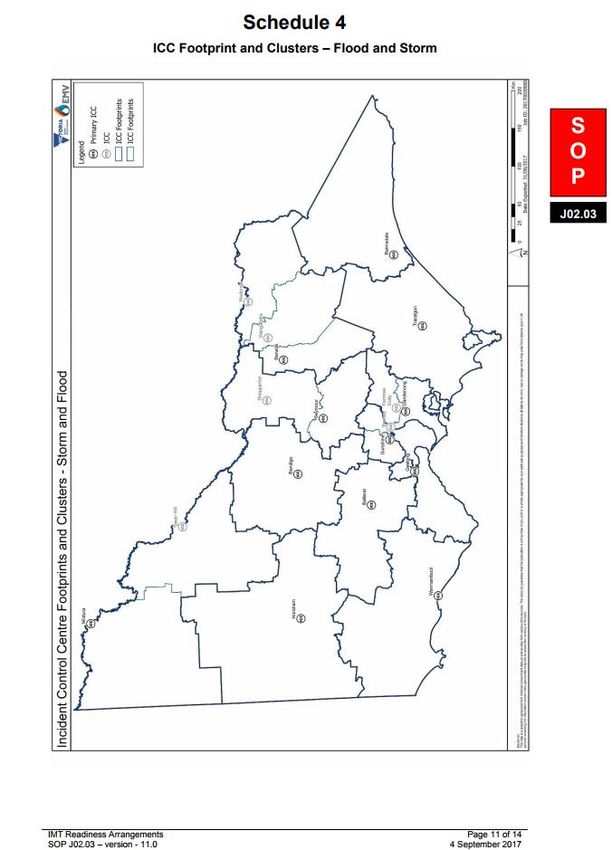
4.3.       Municipal Storm Emergency Planning ................................................................................................. 22
   4.4.       Community Engagement: The StormSafe program............................................................................. 22
   4.5.       StormSafe household and business plans: ......................................................................................... 23
   4.6.       Community safety advice, including for CALD communities and Alpine environments ...................... 23
   5.      Managing a Storm event ....................................................................................................................... 23
   5.1.       Roles and responsibilities .................................................................................................................... 23
   5.2.       Concept of Operations: (refer to VICSES Operations Management Manual V4 July 2018) ............... 23
   5.3.       Escalation and notification ................................................................................................................... 24
   5.4.       Strategic response planning ................................................................................................................ 24
   5.5.       Cross Border Arrangements ................................................................................................................ 25
   5.6.       North East (Hume) Region Control Centre (RCC) ............................................................................... 25
   5.7.       Incident Control Centres (ICCs) ........................................................................................................... 26
   5.8.       Divisional Command Points ................................................................................................................. 26
   5.9.       Possible resource requirements for storms in the North East (Hume) Region .................................... 27
   Glossary .......................................................................................................................................................... 28
   Attachments ................................................................................................................................................... 29
   Attachment 1 – North East (Hume) Region Storm Scenarios ................................................................... 30
   Attachment 2 – North East (Hume) Region Resource List ........................................................................ 32
   Attachment 3 – VICSES Unit Map ................................................................................................................. 36
   Attachment 4 – General Response Boundaries Map ................................................................................. 37
   Attachment 5 – IMT Readiness Levels – Storm (JSOP 2.03) ..................................................................... 38
   Attachment 6 – North East (Hume) Region ICC Footprint Map ................................................................. 41
   Attachment 7 - North East (Hume) Division Command Location Map ..................................................... 42
   Attachment 8 – Hail information ................................................................................................................... 43
   Attachment 9 – Tornado information ........................................................................................................... 44
   Attachment 10 – StormSafe CALD Resources ........................................................................................... 45
   Attachment 11 – Storm RFA Triage Priority Table ..................................................................................... 46
   Attachment 12 – Storm SMEACS briefing sample ..................................................................................... 47

North East (Hume) Region Emergency Response Plan – Storm Sub-plan                                     Version 1, October 2018                                           6
1. Introduction
Storms are Victoria’s most common emergency, and can happen anywhere, at any time of year. They are often
accompanied by strong winds, large hailstones, flash flooding and lightning and can cause significant damage to
homes, businesses, community infrastructure and the natural environment.
VICSES is the control agency for storms within the Victorian Emergency Management Arrangements.
Storms in the context of this plan include: wind, dust, tornados, snow/ blizzards, hail and severe thunderstorms,
including lightning and heavy rain leading to flash flooding.
1.1. Purpose
The purpose of this plan is to provide strategic guidance for the effective and efficient emergency management of
storm impacts in the North East (Hume) Region.
1.2. Objective
The objective of this North East (Hume) Region Emergency Response Plan – Storm Sub-plan is to outline the
arrangements to ensure an integrated and coordinated approach to the management of storm events across the
region, in order to reduce the impact and consequences of storm events on the community, business, tourism,
infrastructure and services.
1.3. Scope
This North East (Hume) Region Emergency Response Plan – Storm Sub-plan includes:
Description of potential risks and consequences of storms to the social, built, economic and natural
environments within the Region.
Region-specific emergency management arrangements for the management of storms.
Links to sources of information where the reader can obtain further detail.
1.4. Authorising environment
The Emergency Management Act (1986 and 2013) is the empowering legislation for the management of
emergencies in Victoria.
The Emergency Management Manual Victoria (EMMV) contains policy and planning documents for emergency
management in Victoria, and provides details about the roles different organisations play in the emergency
management arrangements.
The State Emergency Response Plan (Part 3, EMMV) identifies Victoria’s organisational arrangements for
managing the response to emergencies.
This North East (Hume) Region Emergency Response Plan will
detail specific arrangements for the management of storm
emergencies within the North East (Hume) Region.
This plan has been developed as a subordinate plan of the
North East (Hume) Region Emergency Response Plan and
the State Emergency Response Plan – Storm Sub-plan.
This plan has been shared with the North East (Hume)
Regional Emergency Management Committee for comment,
and approved by the VICSES Chief Officer Operations.
North East (Hume) Region Emergency Response Plan – Storm Sub-plan Version 1, October 2018 7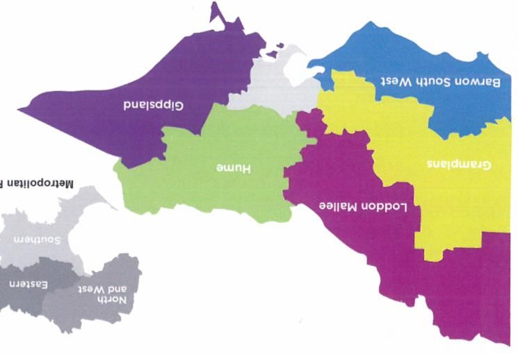
Other relevant legislation includes:
Victoria State Emergency Service Act 2005
Essential Services Act 1958
Planning and Environment Act 1989
Local Government Act 1989
Alpine Resorts (Management) Act 1997
1.5. Activation of the Plan
The arrangements in this plan apply on a continuing basis and do not require activation.
Refer also to Attachment 5: The Storm Readiness and Activation Trigger Consideration Table (V 3.0 Sept 2017).
This table provides guidance based on storm: prediction, actual behaviour, Requests for Assistance (RFAs), line
of control and impacts and consequences.
1.6. Audience
The audience for this plan comprises the Victorian Government and agencies within the emergency management
sector, including business and community groups with a significant role in the management of the emergency.
Although the wider community is not the primary audience, community members may find the contents of this plan
informative.
1.7. Linkages
This plan is a sub-plan of the State Emergency Response Plan – Storm Sub-plan and the North East (Hume)
Region’s Emergency Response Plan. It reflects current Victorian legislation, the arrangements in the State
Emergency Response Plan, the strategic direction for emergency management in Victoria and the accepted State
practice for managing emergencies.
North East (Hume) Region Emergency Response Plan – Storm Sub-plan Version 1, October 2018 8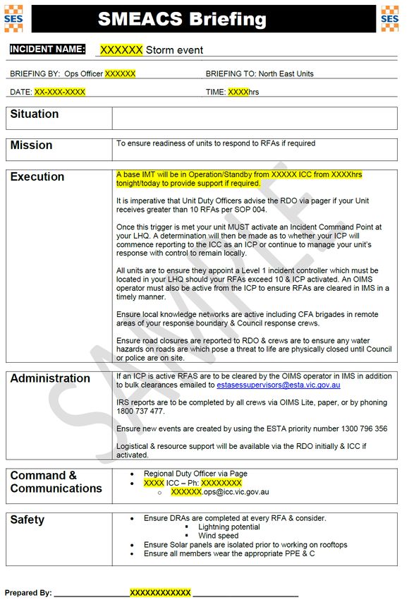
The following storm-related documents are listed for easy location and guidance.
Storm Related: Resources, Hazard plans, JSOPs, VICSES SOPs or Policy Names
Flood plan – State State Emergency Response Plan – Flood Sub-plan
Flood plan – Region North East (Hume) Region Flood Sub-Plan
Landslide Plan State Emergency Landslide Hazard Plan
Camp site mapping DELWP has developed mapping showing location, altitude, etc. for most known camping
areas/camp sites across the region. Available as a layer in EM COP
Hazardous tree A map layer in EM COP indicates fire-damaged tree hazard layers in place in Alpine and
mapping other fire-affected areas
JSOP 2.03 Incident Management Team (IMT) readiness arrangements
JSOP 3.02 Incident naming – major emergencies
JSOP 3.03 Incident action planning including storm SMEACS
JSOP 8.03 Tree hazard (Bushfire Response)
SOP 08 Severe weather notification and activation process
SOP 09 Flood notification and activation process
SOP 019 Operations involving trees
SOP 024 Operations involving powerlines and conductors
SOP 028 VICSES vehicles entering floodwaters
SOP 029 Alpine search and rescue operations
SOP 032 Urban Search and Rescue (USAR) operations
SOP 039 Working safely at heights
SOP 041 Operations involving asbestos
SOP 071 Operations involving solar power and photovoltaic cells
Safety Alert 23 Electrical risks associated with solar arrays
Safety Alert 35 Ladder safety (securing of)
Safety Alert 37 Storm damaged tree operations
Safety Alert 44 Unauthorised tree felling
Policy 10.04 Flash Flood Warnings Policy
Policy 10.02 Local Knowledge
Policy 12.04 After Action Review Policy
Other arrangements for the management of secondary consequences of storms are contained in the following:
For health response – State Health Emergency Response Plan (SHERP)
For rescue – the Victorian Urban Search and Rescue Response Arrangement (USAR)
North East (Hume) Region Emergency Response Plan – Storm Sub-plan Version 1, October 2018 9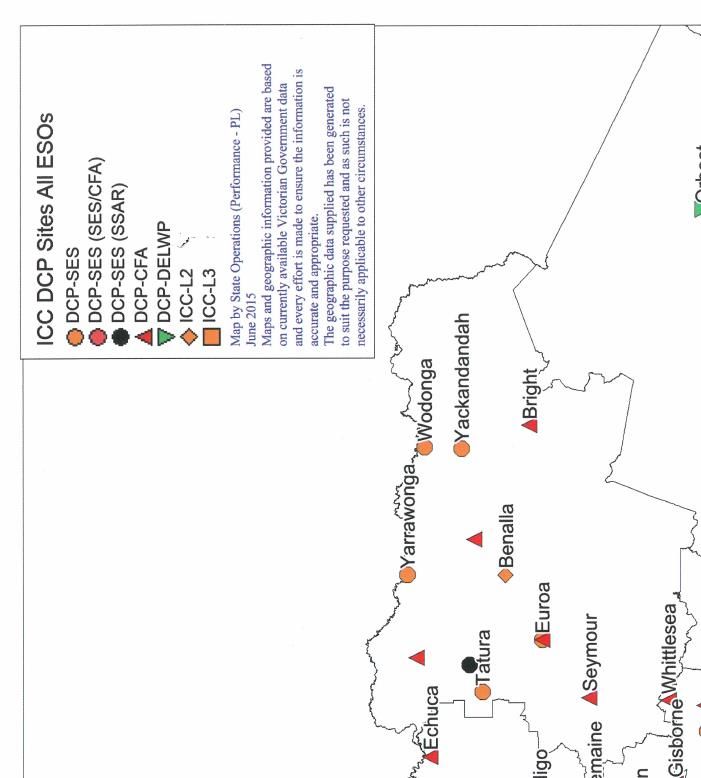
Flood response – State Emergency Response Plan – Flood Sub-plan, and the North East (Hume) Region
Emergency Response Plan – Flood Sub-plan. ses.vic.gov.au/em-sector/vicses-emergency-plans
1.7.1. Thunderstorm Asthma
While uncommon, Thunderstorm Asthma may also be associated with storm events as a result of high pollen
counts and higher than normal levels of humidity. Thunderstorm Asthma arrangements are currently under
development by the Department of Health and Human Services (DHHS) and the Environmental Protection
Authority (EPA).
Arrangements in this plan have not been repeated from afore mentioned plans, unless necessary to ensure
context and readability. All available VICSES Plans can be accessed at ses.vic.gov.au/em-sector/vicses-
emergency-plans
1.8. Exercising and evaluation
This plan will be exercised within one year from the date of approval and once every three years thereafter as part
of a phased cycle. Two North East (Hume) Region Storm Scenarios have been created to support this function,
available in Attachment 1 – North East (Hume) Region Storm Scenario. The exercise will be evaluated and, where
improvements to the emergency management arrangements in this plan are required, the plan will be amended
and a revised version issued. Exercises will be conducted in accordance with the State Exercising Framework,
including debriefs and a formal After Action Review (AAR).
Any operational activity in North East (Hume) Region requiring the management of a storm event will be regarded
as an exercising of the plan. The event is to be evaluated and reviewed, as outlined above.
1.9. Review
This plan is current at the time of publication and remains in effect until modified, superseded or withdrawn.
This plan will be reviewed and updated every three years. Consideration will be given to an earlier revision if the
plan has been applied in a major emergency or exercise, or following a substantial change to the relevant
legislation or arrangements.
2. Storm Risk within the North East (Hume) Region
2.1. North East (Hume) Region description
The North East (Hume) Region extends over 40,000 square kilometres of north eastern Victoria. It contains many
communities that are culturally diverse and is geographically varied, with landscapes and topography that range
from crops to wilderness bushland reserves, to the flat or undulating plains of the north and west, to the mountains
of the Alpine National Park (part of the Great Dividing Range) in the east and south. The northern boundary of the
region is the Murray River and drains the entire course of several significant waterways including the Goulburn,
Ovens, Broken, Kiewa and King rivers.
From the “Mountains to the Murray”, the North East/ Hume Region has a range of built and natural environments,
rugged mountainous landscapes, a diverse economic and agricultural base, unique tourism (including ecotourism
and adventure-based tourism) which can all be vulnerable to, and in some cases influence, storm behaviour (eg.
orographic influence).
The VICSES North East (Hume) Region (see map below) includes four Bureau of Meteorology (BOM) weather
districts (parts or all of): Northern Country, North East, North Central, and the Alpine area.
North East (Hume) Region Emergency Response Plan – Storm Sub-plan Version 1, October 2018 10In the North East (Hume) Region, every Local Government Authority (LGA) has been affected by some kind of
storm and especially prone are the unique environments and climates of the Alpine areas. The region contains
twelve LGAs and four Alpine Resort Management Boards (ARMBs) – see map below.
LGAs: Alpine, Benalla, Greater Shepparton, Indigo, Mansfield, Mitchell (shared with Central Region), Moira,
Murrindindi, Strathbogie, Towong, Wangaratta and Wodonga.
ARMBs: Mt Hotham, Falls Creek, Mt Buller/ Mt. Sterling and Lake Mountain (jointly managed by Southern ARMB
and Murrindindi Shire).
Unlike other regions in provincial Victoria there is no single dominant major regional city, allowing large regional
centres such as Wodonga, Wangaratta, Seymour and Shepparton to service surrounding communities. The
impact of storms on such regional towns, their larger populations, clusters of local to federal infrastructure and
community facilities, key transport links (eg. the Hume Freeway, Melbourne to Sydney rail line, etc.) can be
significant. Likewise, the consequences of isolation in rural and remote communities can also be substantial, for
example, lack of power or access, which can last for days or weeks. For power outage advice:
https://m.powercor.com.au/outage-map or map layer in EM COP.
Alpine Resorts (RMB’s)
Falls Creek/Bogong HP
Mt Hotham/Dinner Plain
Mt Buller/Mt Stirling
Lake Mountain
Not shown: Mt BawBaw (Gippsland region)
2.2. Storm intelligence (before and during events, predictions and
impacts)
Intelligence:
o BOM: predictions/ forecasts and warnings at bom.gov.au/vic, WEBEX 1300 videoconference pre
event (WEBEX in EM COP), Severe weather desk: 03 9669 4978/ 03 9669 1650, Senior
Forecaster 1300 659 217.
o Regional readiness activities (as per JSOP 2.03), eg. briefings/ teleconferences (REMT, Units,
etc.), pre-positioning of specialist teams/ resources.
o Other plans, eg. Municipal Emergency Management Plans (MEMPs).
o A SMEACS tailored for storm is sent to Units pre event (refer to sample Attachment 12, p.44).
North East (Hume) Region Emergency Response Plan – Storm Sub-plan Version 1, October 2018 11o At the Incident Control Centre (ICC), tight liaison with the IMT Intelligence Section (or Planning if Intel not
in place).
o EM COP collection of impacts, photos, etc.
o Social media for information on what the community is experiencing.
Local knowledge: Incorporating local knowledge is vital to the success of the operation
o Local VICSES and/ or CFA volunteers, inputs from local VICPOL members.
o Appoint a Local Information Officer (LIO).
Community observers: Are identified trusted local sources in addition to VICSES members. These
include:
o Leaders within CFA, or CFA ground observers.
o Local police members.
o Senior local government representatives.
o Key community leaders.
o Other established networks, eg. CMA groups.
2.2.1. Managing and prioritising RFAs via 132 500 and 000
An RFA via 132 500 triggers VICSES Dispatch (ESTA) to issue a pager message for a VICSES unit to
respond (attend the scene).
Each RFA is entered into the VICSES Operational Incident Management System (OIMS) (IMS equivalent
in CFA). It is essential to have OIMS operators at large incidents.
Once multiple RFAs are received, they are triaged to ensure a coordinated response and appropriate
allocation of resources. From IMS this may require each RFA to be checked by phone or ground crew
reconnaissance.
Effectively incorporating and triaging 000 calls for assistance at IMT or DIVCOM level is an acknowledged
challenge.
VICSES triages RFAs according to a priority table of 6 categories, ranging from Priority 1, threatened or
entrapped persons, to Priority 6, render private property safe and provide protection from further damage.
For more detail refer to the Prioritising Table found in Attachment 11.
Summary of RFAs and escalation. Refer Operations Management Manual, V4, July 2018 P.63:
Storm
RFA’s per RFA’s per
Readiness Comments
UNIT REGION
Activation Level
Level 1 Local 1-5 Rural Community impact/ consequences may prompt escalation.
Managed locally: UDO/RDO/RAC.
1-10 urban
Level 2 20-30 Rural Community impact/ consequences may prompt escalation.
Managed locally or with ICP: UDO/RDO/RAC/RC.
60-75
SAC/SDO monitoring.
Urban
Level 3A 20-30 Rural 60-100 Rural Community impact/ consequences may prompt escalation.
Managed from ICP(s). 3+ ICP’s. RC in place
60-75 200-250
RCC/SAC/SDO/ SCC.
Urban Urban
Level 3B and 30 + Rural 100 + Rural Community impact/consequences may prompt escalation.
above
75 + Urban 250 + Urban Managed with one or more: ICP/SCP/DCP/ICC/RCC.
RDO monitors incidents outside ICC and BAU.
North East (Hume) Region Emergency Response Plan – Storm Sub-plan Version 1, October 2018 122.3. North East (Hume) Region storm risk and warnings
Storms are Victoria’s most common emergency with hundreds of storms occurring each year.
Storms can happen anywhere, at any time of year.
Storms (whether severe or not) have the potential to result in loss of life.
North East (Hume) Region is also prone to tornadoes.
Historically the North East (Hume) Region has experienced frequent, significant and varied types of storms
resulting in:
Loss of life, injuries (especially during wind-related events, and often in vulnerable locations, eg. camping
locations).
Destruction or damage to buildings (including roofs, solar panels), infrastructure (eg., power outages), the
environment, including agriculture (especially wind, hail, lightning or heavy rainfall related storms).
Heavy rainfall can lead to flash flooding, overland flooding and riverine types of flooding. The last significant
riverine flood events were: 2010, 2012 and 1993. For information on local riverine flooding, refer to the VICSES
North East (Hume) Region Flood Response Plan: ses.vic.gov.au/em-sector/vicses-emergency-plans.
2.3.1. Storm definitions
Storms in the context of this plan include: wind, dust, tornados, snow storms, blizzards, hail and severe
thunderstorms, including lightning and heavy rain leading to flash flooding.
Not all storms are "severe", are a risk to life, or produce damage, however those that can and do have specific
naming and characteristic criteria.
Storm-related warnings are issued by BOM for weather events that may produce damaging and dangerous
phenomena. These do not include warnings specifically for snow storms or dust storms (other than “raised dust”)
– refer to the table below for more information. A full version of this table is contained in the State Emergency
Response Plan – Storm Sub-plan: ses.vic.gov.au/em-sector/vicses-emergency-plans.
Criteria for issuing Severe Thunderstorm Warnings and Severe Weather Warnings:
Weather Severe Thunderstorm Severe Weather Warning: issued if the phenomena are not
Phenomenon Warning: issued if directly caused by severe thunderstorms and not covered by
phenomena caused by the cyclone or fire weather warnings
thunderstorm
Wind (Gusts) Gusts 90 km/h or more Gusts 90 km/h or more
Wind (average) Widespread winds over land 63 km/h or more (Gale force)
Tornado All tornadoes
Snow storm No warnings as such issued, other than snow down to XXX metres
Dust No warnings as such issued, other than “raised dust” as a secondary consequence
Blizzard Widespread blizzards in Alpine areas
Flash Flood Heavy rainfall conducive to Heavy rainfall is conducive to flash flooding or a reported
flash flooding or a reported flash flood
flash flood
Large Hail Hail with size of at least 2 cm
2.3.2. Storm Warnings
Victorian BOM weather and VICSES storm warnings are issued via EM COP (Public Publisher) using the
HUME distribution list. Vic Emergency is Victoria's combined distribution source
North East (Hume) Region Emergency Response Plan – Storm Sub-plan Version 1, October 2018 13of emergency information, warnings and advice to communities, via the Vic Emergency website
(emergency.vic.gov.au), the Vic Emergency app and the Vic Emergency Hotline (1800 226 226).
A VICSES State Duty Officer (SDO), or on request, the State Control Centre (SCC) Warnings and Advice
Duty Officer (WADO), or an operating Incident Control Centre (ICC) with appropriate approvals, can
localise or tailor the BOM warnings as per the VICSES SOP 008 Severe Weather Notification and
Activation Process.
2.3.3. Severe Weather and Severe Thunderstorms
Severe Thunderstorm Definition:
In Australia, Severe thunderstorms are defined by BOM as those that produce any of the following attributes:
Lightning.
Hailstones with a diameter of 2cm or more.
Damaging and destructive winds (between 52km/h and 102km/h) or greater.
Flash flooding from heavy localised rain.
Tornados.
Wind Gusts of 90km/h or greater.
Blizzard conditions: strong winds in conjunction with blowing or falling snow with an expected reduction in
visibility to less than 200 metres.
Only about 10% of thunderstorms are severe, but these account for approximately 90% of the damage produced
by all thunderstorms (and all thunderstorms produce lightning which can cause death, injury and damage).
For more about severe weather or thunderstorm warnings go to: bom.gov.au/weather-services/severe-weather-
knowledge-centre/WarningsInformation_SW_SWW.shtml
For more about storms go to the BOM Storm Spotters Handbook:
bom.gov.au/storm_spotters/handbook/foreword.shtml
Very Dangerous Thunderstorm Definition:
A Severe Thunderstorm Warning issued by BOM may be exceeded by a Very Dangerous Thunderstorm Warning.
A Very Dangerous Thunderstorm is defined as one that produces:
Hailstones with a diameter of 5cm or more; and/or
Wind gusts of 125km/h or greater.
2.3.4. Severe Thunderstorm Climatology
The most frequent types of severe weather events in the North East (Hume) Region that are not directly related to
thunderstorms are wind storms (land gale force winds) associated with the passage of a cold front or intense low
pressure systems crossing the region. These can occur at any time of year although are more common in the
winter and spring months when intense low pressure systems and cold fronts are stronger and more common.
2.3.5. Severe Weather Climatology
Severe weather trends in the North East (Hume) Region of Victoria:
Most severe thunderstorms occur between October and April.
Although severe thunderstorms can occur at any time of the day or night, it is the afternoon and evening
period when severe thunderstorms are most frequent.
January is the most active month for Severe Thunderstorms followed by December then November. The
number of events when large hail or heavy rainfall is reported follows this overall trend closely, with very
few events during the winter months.
North East (Hume) Region Emergency Response Plan – Storm Sub-plan Version 1, October 2018 14 Conversely, the number of tornado events is quite evenly distributed throughout the year. This could be
due to the fact that tornados can form in cold-air mass thunderstorms as well as in warm-air mass super
cell thunderstorms.
Other observed local impacts in the North East (Hume) Region:
Orographic effect is the change in atmospheric conditions caused by a change in elevation, primarily due
to mountains. Orographic precipitation, (rain, snow, etc.) is produced when moist air is lifted as it moves
over a mountain range. As the air rises and cools, orographic clouds form and serve as the source of
the precipitation, most of which falls upwind of the mountain ridge.
Tornadoes frequently track across northern Victoria and along the Murray River.
Victoria’s section of the Great Dividing Range provides a “rain shadow-like” deflective effect on East Coast
Lows that may affect the Gippsland (East) region.
Snow hazards
Snow can fall in alpine regions all year round.
A blizzard (as per the BOM definition) is a violent and very cold wind which is loaded with snow, some of
which has been raised from snow covered ground. Reduced visibility makes it easier to lose your bearings,
even if you're familiar with the area. White-out conditions (uniform whiteness) in a snowy landscape can take away
all reference points. It does not have to be snowing for there to be blizzard conditions and the winds should
be at least gale force (average 63km/h or more). Blizzards are confined to Alpine areas in Victoria and
mainly occur during the winter and early spring months, but can also occur in autumn.
Heavy snow (as per the BOM definition) creates reduced visibility of paths, signs and hazards, and makes
travelling, navigation and/ or rescue difficult. Large snow accumulations may slip off rooftops, or cause
trees or their limbs to fall. Impacts include increased risk of hypothermia (especially if snow combines with
wind), increased risk of accidents due to compacted snow and ice on roads, and increased avalanche
danger.
For more about snow safety go to: www.snowsafe.org.au.
2.4. Regional VICSES and multiagency resources for storms
Expert multi-agency resources may be accessed during operations through the Australasian Inter-Service Incident
Management System (AIIMS) structure. This support is initiated/ accessed in the first instance by the VICSES
RDO via the Regional Agency Commander (RAC) to the Hume Regional Emergency Management Team (REMT).
A map of VICSES Unit boundaries is provided in Attachment 3 or accessible via EM-COP for registered
users.
A full list of VICSES and key multiagency North East (Hume) Region resources can be accessed in
Attachment 2.
3. Consequences
3.1. Possible storm consequences including Business Continuity
arrangements
The North East (Hume) Region has many communities (including tourists and campers) and locations prone to
and vulnerable to storm events. These locations include areas where topography can also influence storm
behaviour, such as known wind “hot spots” like Kilmore Gap, Lake Nillachootie and King Valley’s wind funnelling
effect, and in Alpine areas where wind effects are more pronounced due to the altitude.
The effects of storm on the community can include (but are not limited to):
Loss of life, serious injury or other health impacts (including reaction to Thunderstorm Asthma).
Damage to or loss of:
o Key infrastructure – road, rail, public buildings.
North East (Hume) Region Emergency Response Plan – Storm Sub-plan Version 1, October 2018 15o Essential services – power (mains and alternatives, eg. solar), potable water, sewage, gas,
telecommunications, internet (for power outages go to https://m.powercor.com.au/outage-map or
refer to the power outage map layer in EM COP).
o Private property.
o Industry/ business/ tourism (including ecotourism and major tourism events).
o Agriculture/Viticulture – livestock, crops, orchards, plantations, etc.
o Damage to the environment.
o Access and egress delays affecting emergency responders and community impacts such as
evacuation.
VICSES Business Continuity Arrangements
In the event that the Regional Office or other VICSES facility is impacted by the emergency, each location has a
Business Continuity Plan in place. Each plan details back up arrangements to maximise the potential to operate
and respond as per normal (eg. generator to counteract power outages, fuel supplies, etc.). These plans can be
located in HPRE, or hard copy at the Benalla RCC.
3.1.1. Special considerations for Alpine areas
Add 10 km/hour to average winds or gusts predictions.
Wind damage to buildings in Alpine areas is usually reduced by enhanced building codes which have
strengthened most Alpine resort buildings.
Alpine/resort roads can be significantly impacted by fallen trees, especially in fire-affected areas. A map
layer in EM COP indicates fire damaged tree hazard layers in place in Alpine and other fire-damaged
areas.
Refer also to Storm Readiness and Activation Trigger table in Attachment 5.
3.1.2. Cascading secondary consequences (including road access, agricultural impacts, etc.)
Significant community disruption can occur as a result of damage to essential infrastructure, which may lead to
cascading secondary consequences.
For example, wind damage along roadside vegetation corridors can create access/ egress issues or road
closures, while a loss of power may result in a loss of potable drinking water supply, sewage systems,
telecommunications, traffic and railway crossing signals and disruption to critical supply chains (eg. dairy farm
milking and milk collection).
Damage, landslides and flooding of road infrastructure may also result in isolation of properties and/or
communities which can take days or weeks to restore in a major incident or in remote areas.
Information on building critical infrastructure resilience can be found in the State Emergency Response Plan –
Storm Sub-plan. This is supported by the Victorian Critical Infrastructure Resilience Strategy available at
emv.vic.gov.au/our-work/critical-infrastructure-resilience.
3.2. Local storm history
The following tables below provide information about historical storms within the North East (Hume) Region,
sorted by type and chronological date, with fatalities listed in red (where known).
BOM’s storm archive (bom.gov.au/australia/stormarchive/) and VICSES’ records of recent events show the North
East (Hume) Region to be very susceptible to severe storms, including tornadoes, large hail, flash flooding,
severe winds and lightning. Though there are few dust storm events that have specifically impacted this region.
People in the open, under trees or camping, are statistically the most vulnerable to death due to storm.
North East (Hume) Region Emergency Response Plan – Storm Sub-plan Version 1, October 2018 16Table 1: Tornado event history
Tornado snapshot: Summary of local impacts: Sheds/homes/caravans destroyed, damaged/ unroofed; leaves
stripped off trees/vineyards/orchards; significant asbestos exposures. Refer to Attachment 9, page 39: Tornado
EF Enhanced Fujita Scale Information and Resources.
Year / Locality
Description
Fatalities impacted
28 Mar 2018 Tolmie 8 homes damaged.
1 Nov 2015 Impacted An estimated EF2 tornado left a damage path approx. 45km long with wind-
areas: related damage reports in Nathalia, Strathmerton, Torrumbarry and Cobram.
Nathalia, Homes were stripped of roofs and some were all but destroyed, deemed
Strathmerton, uninhabitable.
Torrumbarry BOM noted “the tornado filmed (moving through Nathalia), corresponded to
and Cobram the inflexion point of the squall line on the radar” and “winds up to 130 km/h
at 3500 ft along the back edge of that squall line.”
At Torrumbarry “trees were brought down and ripped tin roofing off one
house, tearing away the battens to which it was attached.”
24 Jul 2015 Lake Hume A waterspout was filmed on Lake Hume as a “tornadic” thunderstorm passed
tornado- over the lake.
waterspout
23 Feb 2015 Nathalia area 10 homes damaged.
21 Mar 2013 Significantly A total of 7 tornadoes touched down
(Easter) impacted More than 20 people injured and taken to hospital, with two in a critical
areas: condition.
Koonomoo,
Multiple
Bundalong, Wind gusts between 180-250 km/h cut a path of destruction.
injuries (>20)
(Mulwala VICSES received 150 RFAs for damage to properties, businesses and
NSW), infrastructure.
Rutherglen, One tornado rated at EF4 (believed to have been the most powerful tornado
Euroa, to have ever hit Victoria) struck the towns of Koonoomoo, Cobram, Barooga,
Swanpool, Mulwala (NSW side of Yarrawonga), Yarrawonga, and Bundalong, followed
Benalla and by a second tornado from the same storm at Rutherglen between 6:50pm-
Mansfield 8:30pm. Roofs were ripped off homes, caravans were upturned, Barooga
Post Office was heavily damaged.
A tornado rated EF3 struck the towns of Tamleugh, Euroa and Swanpool.
One petrol station was damaged at Euroa.
Further tornadoes touched down near Benalla (EF0), and two near
Mansfield (EF0 and EF1).
9 Nov 2011 Bellbridge 12 houses damaged, some with roofs blown off; trees uprooted.
/Bethanga
area (near
Wodonga)
26 Nov 2002 Myrtleford It was reported that damage was consistent with that of an EF2 tornado.
Wind event Buildings were damaged and a person was injured due to the collapse of a
(possible partially built house.
Tornado)
2000 Milawa 12 houses damaged, roof blown off church.
Sept 1989 Albury area Man killed by falling tree. Albury in darkness after $2 million fire in substation.
1 fatality (NSW)
(Wodonga
“sister” city)
1964 Numurkah 50 homes damaged.
26 Oct 1865 Beechworth Massive damage to Beechworth churches, school demolished, houses
1 fatality Wind event unroofed and objects thrown great distances. Man died inside a collapsed hut,
Multiple (possible numerous other injuries.
injuries Tornado)
North East (Hume) Region Emergency Response Plan – Storm Sub-plan Version 1, October 2018 17Table 2: Lightning event history
Lightning Snapshot: Summary of local impacts: Death/injury to humans and livestock (cattle, pigs, horses,
sheep), lightning igniting significant bush/grassfires, building/infrastructure damage.
Year / Fatalities Locality impacted Description
16 Mar 2009 Bright Lightning struck tree at Bright pony club under which people
1 fatality were sheltering. One adult female died.
Dec 2006-Feb Alpine, Great Divide fires Victoria's longest running bushfire (69 days). Caused by 87
2007 confirmed lightning strikes. More than 1 million ha of land burnt.
New Zealanders, Canadians and Americans joined more than
19,000 firefighters from across Australia to fight the blaze. The
cost of the fire was more than $200 million.
End 2003-early Upper Murray to the King Multiple lightning strikes result in 1 million ha Alpine “megafire.”
2004 Valley
1995 Yackandandah Records indicate multiple significant lightning storms listed for
1 fatality Yackandandah over time, including causing a house fire.
1938 Yea Child killed.
1 fatality
Table 4: Wind storm event history
Wind Storm snapshot: Summary of local impacts: Death/injury to humans, building damage ranging to complete
destruction, significant infrastructure impacts (power and communications), agriculture/ horticulture/ viticulture
impacts/damage/flattening.
Areas often subject to winds 100 km/h and Shepparton (156 km/h 2010), Mangalore (133 km/h, 1993),
over Yarrawonga (130 km/h 1997), Alexandra (128 km/h 1993,) and
Mt Buller (128 km/h 2016).
Multiple reports over 100 km/h: Broadford, Bullioh, Myrtleford,
Tawonga, Corryong , Dookie, Benalla.
Year / Fatalities Locality impacted Description
Feb 2018 Gundowering-Bright area Multiple paraglider rescues after unexpected wind change.
Dec 2017 pre Widespread windstorm 60,000 homes and businesses without power, telecoms, road
XMAS throughout North East, and property access for several hours (to days/weeks) in King
particularly Cheshunt/King Valley/Cheshunt area. Many homes/buildings with roof damage,
Valley including caravan parks.
13 Feb 2013 Harrietville (in active fire A falling tree at 1530 struck a vehicle, killing two firefighters
2 fatalities area) during a windstorm on the Harrietville-Alpine north area fire
ground.
6-7 Mar 2010 Shepparton area Winds around Shepparton 156 km/h. Major Storms in Melbourne
and the North East (Hume) Region – major impact in
Shepparton with path towards Alexandra. See 10 min
documentary: youtube.com/watch?v=r0VvbGyi6E0
2010 Wangandary/Wangaratta “Microburst.”
9 Feb 2009 “Black Saturday” A series of bushfires that ignited when power lines were
121 fatalities bushfires: Kilmore Fire damaged/ made contact in high winds started the Kilmore East
(Murrindindi/ Marysville) and Beechworth fires, resulting in 121 fatalities and 1280 homes
and the Beechworth Fire damaged or destroyed. Class action claimed against electrical
(Mudgegonga/ Kiewa V) supplier. Significant infrastructure upgrades since.
2007 Mt Hotham “Microburst.”
1 Mar 2005 Wodonga “Microburst,” roofs blown off houses including motel. 230 RFAs.
Major disruption including train derailment.
2003 Beechworth “Supercell.”
2000 1 Wodonga A person was killed due to a branch breaking in strong winds.
fatality
Jun 1998 2 Delvin’s Bridge, Melba Gum tree fell across highway, killing driver and passenger. High
fatalities Highway winds for two days, rain softened soil.
1996 Cobram Strong winds caused branch to fall on people camping under
2 fatalities trees.
1995 Corryong 23 homes damaged.
North East (Hume) Region Emergency Response Plan – Storm Sub-plan Version 1, October 2018 181995 Benalla 66 homes damaged, hospital damaged, no power to 1,000
homes.
1988 Yea – Marysville Woman killed in Murrindindi area.
1 fatality
1980 Mooroopna 12 houses damaged.
1981 Shepparton 22 homes damaged.
Jan 1968 Steavensons Falls Four teenagers bush walking near the bottom of the
4 fatalities Marysville Steavensons Waterfall killed by a large section of a mountain
ash tree which fell during a wind storm.
Jan 1960 Hume Weir 3 deaths after boat capsizes in strong winds. Tallangatta Hotel
3 fatalities unroofed.
Table 5: Hail storm event history
Hail Storm snapshot: Summary of local impacts: Severe crop/orchard/vineyard damage, horse, cattle, sheep
and goat losses. See Attachment 8, page 38 for hail resources. Only significant hail size listed.
Locality impacted Description
Tarrawingee 4.2 cm
St James 7 cm “baseball”
Kinglake 6 cm
Whorouly 7 cm
Mt Beauty 7 cm “fist size”
Tallangatta 4 cm “chicken egg”
Table 6: Snow/blizzard event history
Significant Snow/ blizzard snapshot: Summary of local impacts: fatalities and motor vehicle accidents.
Year Locality impacted Description
10 to 13 Sept Stanley,Beechworth area Stanley, 7km south east of Beechworth, was blanketed in snow
2005 while heavy snowfalls in Beechworth lasted for about an hour
2 fatalities from 3pm. Two people were killed when their car skidded off the
icy Beechworth-Wangaratta Road at Black Springs about
6.20pm. Snow was also reported from Edi Upper in the King
Valley, 365m above sea level.
19 July 2014 Mt Bogong, Bogong High Two snowboarders were swept to their deaths in the Victorian
2 fatalities Plains (BHP) back country of the Mt Bogong High Plains.
Table 7: Very heavy rain/flash flood event history
Significant rain, storm, flash flood snapshot: Summary of local impacts: Drowning/ rescues/ injury to
humans/ livestock, railway washed away, mudslides/ landslides/ debris flows.
Year Locality impacted Description
2 Dec 2017 Euroa, Strathbogie Statewide 250mm rainfall forecast within 24 hrs. 150mm had
Ranges already fallen in many areas. 7.4 million people received SMS
warning message. 190mm fell in Strathbogie Ranges (Mt
Wombat). Homes flooded in Euroa, two rescues in Balmattum
and Cathkin. Final days of Great Victorian Bike Ride cancelled.
Dec 2016 Harrietville - Mt Hotham Flash flooding causing landslide. 178mm of heavy rain in recent
bushfire area washed away a section of the Great Alpine Road
(GAR, above Harrietville). GAR closed for repair for 6 weeks.
Significant power outages.
18 Sep 2016 Toolamba near Two campers rescued after becoming stranded by rising
Shepparton Goulburn River floodwater; stuck inside their vehicle with two
dogs. Rescued by locals. Emergency services withdrew due to
the risk.
3 Jan 2016 Whiteheads Creek at Slow moving storm resulted in 1.7m deep water at Delatite Road
1 fatality Seymour crossing. Man drowns even though crossing has flood warning
indicators. Darkness likely concealed floodwater. 170 RFAs
overnight including at Seymour, Wangaratta and Euroa.
North East (Hume) Region Emergency Response Plan – Storm Sub-plan Version 1, October 2018 19Mangalore 41mm, Nagambie 79mm.
Oct 2016 Bogong High Plains Road Road closed due to numerous landslides.
Jul 2016 Harrietville Complete loss of telephone communications.
Dec 2015 Ovens - Eurobin Flash After heavy rainfall (Eurobin 41.6mm in30 min, Ovens 63mm in
flooding and landslide 30 min), landslide damaged three homes, with one deemed
uninhabitable, and Great Alpine Road closed by significant
debris flow. Catchment area also had recent fuel reductions
works completed.
28 Sep 2011 Tolmie Thunderstorms and heavy rain across Victoria. Tolmie weather
station recorded the highest record of 101mm in a day
Jan- Feb 2011 Northern section of the The 2010-11 series of flood events were associated with the
1 fatality Goulburn River, especially breakdown of El Niño conditions and the development of one of
the Shepparton- the strongest La Niña events observed since the late 1800’s. In
Mooroopna area, Harston, January 2011, most of Victoria was drenched with record rains
Rutherglen and exceptional humidity. Severe thunderstorms developed over
Victoria as a result of the tropical moisture associated with
Tropical Cyclone Anthony and ex Tropical Cyclone Yasi
(category 5). A persistent low pressure system and this tropical
moisture resulted in over 150 rainfall stations across Victoria
recording their wettest January ever, as well as record January
daily rainfall (including areas of north-east Victoria where
140mm of rain fell in 20 minutes at Rutherglen). The North-West
and Central regions were hardest hit. Approximately 1/3 of
Victoria experienced some form of flooding or storm damage,
resulting in enormous cost and disruption to regional, urban and
rural communities. Across the state, an estimated $6 billion was
spent in damages.
Main waterways affected in this region: the lower Goulburn
River (especially In Shepparton and Mooroopna) and the
Campaspe River running along the region’s western border.
On 18 January, a police diver found the body of a boy who
went missing on 17 January while playing on a raft in a
flooded Goulburn River billabong.
Over 50 houses flooded and 500 houses were isolated due
to Goulburn River flooding.
In Rutherglen, the Main Street flooded (flash flooding).
27 Nov 2010 Kilmore, Violet Town area Flash flooding closed Hume Freeway.
4 - 7 Sept 2010 See North East Region The 2010-11 series of flood events were associated with the
Flood sub plan for more breakdown of El Niño (and drought) conditions and the
detail development of one of the strongest La Niña events
observed since the late 1800s.
Multiple communities and In 2010 heavy rain fell in most regions of the state,
locations impacted along particularly at higher altitudes of the North East/Hume
the Ovens, region, flooding the upper reaches of many of Victoria's
King, Kiewa, Goulburn major rivers. Warm rain on a significant snowfall also
and increased the run off into the region’s waterways increasing
flood levels at a very rapid rate in some locations.
Broken Rivers, Seven and
Castles Creek, and their In North East Victoria, every main river basin north of the
many tributaries Great Dividing Range experienced major flooding and
remains the next most significant flooding since 1993.
Highest Rainfall rate of 180mm (7.08”) at Mt Buffalo over the
weekend of 4-5 August 2010.
Several landslides in the Alps including Mt Hotham, Falls
Creek and Mt Buller leaving hundreds of skiers stranded.
Mudslides in Mitta Valley after 210mm fell in 60 minutes.
2001 Gundowering, Eldorado 71.1mm in 30 minutes.
1995 Tallangatta Valley 270mm in 55 minutes.
1995 Benalla/Lurg 94mm 60 minutes.
1993 Mt Buffalo 212mm 24 hours.
1993 Benalla 100mm (163 points) in 20 minutes.
1992 Tallangatta Valley 150mmin 2 hours.
North East (Hume) Region Emergency Response Plan – Storm Sub-plan Version 1, October 2018 20You can also read