TROPICAL CYCLONE OPERATIONAL PLAN FOR THE BAY OF BENGAL AND THE ARABIAN SEA
←
→
Page content transcription
If your browser does not render page correctly, please read the page content below
WORLD METEOROLOGICAL ORGANIZATION
TECHNICAL DOCUMENT
WMO/TDNo. 84
TROPICAL CYCLONE
PROGRAMME
Report No. TCP21
TROPICAL CYCLONE OPERATIONAL PLAN
FOR THE BAY OF BENGAL AND THE ARABIAN SEA
2007 Edition
SECRETARIAT OF THE WORLD METEOROLOGICAL ORGANIZATION
GENEVA SWITZERLAND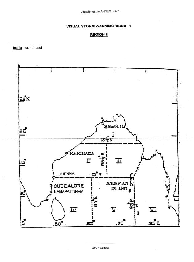
©
                                World Meteorological Organization

                                             NOTE

The designation employed and the presentation of material in this document does not imply the
expression of any opinion whatsoever on the part of the Secretariat of the World Meteorological
Organization concerning the legal status of any country, territory, city or area or of its authorities, or
concerning the delimitation of its frontiers or boundaries.
(iii)
CONTENTS
Page
Chapter I General I1
1.1 Introduction I2
1.2 Terminology used in the region I2
1.2.1 General I2
1.2.2 Classification of cyclonic disturbances and
tropical cyclones I2
1.2.3 Tropical cyclone characteristics I2
1.2.4 Terms related to the warning and warning system I2
1.3 Meaning of terms used for international exchanges I3
1.4 Units used I5
1.4.1 Units used in international exchanges I5
1.4.2 Units used in national bulletins I5
Chapter II Tropical cyclone warnings and advisories II1
2.1 General II1
2.2 Classification of cyclonic disturbances II1
2.3 Identification of tropical cyclones II1
2.4 Tropical weather outlook II1
2.5 Tropical cyclone advisories II2
2.6 Tropical cyclone warnings for the high seas II2
2.7 Warnings and advisories for aviation II7
2.8 Tropical cyclone warnings for national purposes II6
Annex IIA Tropical cyclone warning systems in the Panel countries IIA1
Chapter III The observing system and observing programme III1
3.1 Networks of surface and upperair stations III1
3.1.1 Observations from basic networks III1
3.1.2 Special observations from the WWW network III1
3.1.3 Special observations from stations other than
those of the regional basic synoptic network III1
3.1.4 Upperair stations III9
3.2 Observations from mobile ships III9
3.3 Aircraft reports III9
3.4 Radar observations III9
3.5 Satellite observations III10
Annex IIIA Code for reporting radar observations relating to
cyclonic disturbances IIIA1
Annex IIIB Satellite cloud imagery monitoring facilities IIIB1
in the Panel countries
2007 Edition(iv)
Page
Chapter IV Tropical cyclone forecasting IV1
4.1 Forecasting development and movement of tropical cyclones IV1
4.2 Storm surge forecasting IV1
Annex IVA Processed products transmitted by
RSMC tropical cyclones New Delhi for international purposes IVA1
Chapter V Communications V1
5.1 General V1
5.2 Procedures to be followed V1
5.2.1 Tropical cyclone warning headings V1
5.2.2 Telecommunication headings for the exchange of radar observations V1
5.2.3 Telecommunication headings for the exchange of other messages V2
5.2.4 Telecommunication headings for the exchange of tropical V2
cyclone advisories and warnings for aviation
5.3 Existing GTS circuits among the Panel countries V2
5.4 List of important telephone numbers and addresses connected V2
with tropical cyclone warnings in the Panel countries
5.5 GMDSS V2
Annex VA List of important addresses and telephone
numbers connected with tropical cyclone VA1
warnings in the Panel countries
Chapter VI Monitoring and quality control of data VI1
6.1 Monitoring of data VI1
6.2 Quality control VI1
Chapter VII Archival of data VII1
7.1 Necessity for data archival VII1
7.2 Tropical cyclone data on landfall VII1
7.3 Role of RSMC tropical cyclones New Delhi in data archiving VII1
Annex VIIA Global Tropical Cyclone Track and Intensity Data Set VIIA1
Report Format
______________________
2007 Edition(iv) 2007 Edition
I1
CHAPTER I
GENERAL
1.1 Introduction
The loss of life and property and human suffering caused by tropical cyclones in coastal areas in
various parts of the globe are well known. These disasters are, on occasion, particularly severe in the Bay of
Bengal region. The northern part of the Bay of Bengal is known for its potential to generate dangerous high
storm tides a major killer when associated with cyclonic storms. In the past, out of 10 recorded cases of
very heavy loss of life (ranging from about 40,000 to well over 200,000) in the world due to tropical cyclones,
8 cases were in the Bay of Bengal and the Arabian Sea (5 in Bangladesh and 3 in India). The world's highest
recorded storm tide of 45 feet occurred in this region (1876, Bakherganj cyclone near Meghna Estuary,
Bangladesh). These facts amply illustrate the importance of an efficient cyclone warning service in this
region. Recognizing these facts, the World Meteorological Organization (WMO) and the Economic and
Social Commission for Asia and the Pacific (ESCAP) jointly established the Panel on Tropical Cyclones in
1972 as an intergovernmental body. Its membership comprises countries affected by tropical cyclones in
the Bay of Bengal and the Arabian Sea. Originally its member countries were Bangladesh, India, Myanmar,
Pakistan, Sri Lanka and Thailand. Later Maldives joined this Panel in 1982 followed by Sultanate of Oman in
1997.
The Panel is one of the five regional tropical cyclone bodies established as part of the WMO
Tropical Cyclone Programme (TCP) which aims at promoting and coordinating the planning and
implementation of measures to mitigate tropical cyclone disasters on a worldwide basis.
The main objective of the WMO/ESCAP Panel on Tropical Cyclones is to promote measures to
improve tropical cyclone warning systems in the Bay of Bengal and the Arabian Sea.
As part of this endeavour, the Panel at its twelfth session adopted a comprehensive cyclone
operational plan for this region. The basic purpose of the operational plan is to facilitate the most effective
tropical cyclone warning system for the region with existing facilities. In doing so the plan defines the sharing
of responsibilities among Panel countries for the various segments of the system and records the
coordination and cooperation achieved. The plan records the agreed arrangements for standardization of
operational procedures, efficient exchange of various data related to tropical cyclone warnings, issue of
cyclone advisories from a central location having the required facilities for this purpose, archival of data and
issue of a tropical weather outlook for the benefit of the region.
The operational plan contains an explicit formulation of the procedures adopted in the Bay of
Bengal and Arabian Sea region for the preparation, distribution and exchange of information and warnings
pertaining to tropical cyclones. Experience has shown that it is of great advantage to have an explicit
statement of the regional procedures to be followed in the event of a cyclone, and this document is designed
to serve as a valuable source of information always available for reference by the forecaster and other
users, particularly under operational conditions. Relevant information, which is not subject to regional
agreement is given in the annexes to the plan.
A technical plan aiming at the development and improvement of the cyclone warning system of the
region has been drawn up by the Panel. Implementation of some items under the technical plan would lead
to a strengthening of the operational plan.
The operational plan is evolutionary in nature. It is intended that the text of the plan be updated or
revised from time to time by the Panel and that each item of information given in the annexes to the plan be
kept up to date by the member country concerned.
2007 EditionI2
1.2 Terminology used in the region
1.2.1 General
Panel members or member countries or countries
Zone of disturbed weather*
1.2.2 Classification of cyclonic disturbances and tropical cyclones
Cyclonic disturbance (generic term: i) viii))
i) Low or low pressure area
+
ii) Well marked low
iii) Depression or tropical depression
iv) Deep Depression*
Tropical cyclone (generic term: v) viii))
v) Cyclonic storm
vi) Severe Cyclonic storm
vii) Very severe cyclonic storm
viii) Super cyclonic storm
1.2.3 Tropical cyclone characteristics
i) Position or location
ii) Eye
iii) Centre
iv) Centre fix
v) Central pressure
vi) Pressure depth
vii) Direction of movement
viii) Speed of movement
ix) Mean wind speed or sustained wind speed
x) Maximum wind speed
xi) Gust
xii) Storm surge
xiii) Storm tide
1.2.4 Terms related to the warning and warning system
i) Name of the Tropical Cyclone
ii) Tropical cyclone season or cyclone season
iii) Tropical cyclone advisories
iv) Tropical cyclone information bulletin
v) Satellite information
vi) Precyclone watch**
vii) Cyclone Alert*
viii) Cyclone Warning*
ix) Post landfall outlook**
x) Visual storm signal
xi) Squally wind
xii) Gale wind
xiii) High sea bulletin
xiv) Coastal weather bulletin
xv) Bulletin or cyclone warning bulletin
_____________________________
** Term used nationally in India
* Term used nationally in Bangladesh, India and Pakistan;
+
Term used nationally in Bangladesh.
2007 EditionI3
1.3 Meaning of terms used for international exchange
Average wind speed: Speed of the wind averaged over the previous 10 minutes (mean surface wind) as
read from the anemogram or the 3 minutes mean determined with the nonrecording anemometer or
estimated wind at sea by the mariners using the Beaufort scale.
Bulletin: Cyclone warning bulletin
Central pressure of a tropical cyclone: Surface pressure at the centre of the tropical cyclone as
measured or estimated.
Centre fix of the tropical cyclone: The estimated location of the centre of a tropical cyclone (obtained by
means other than the aircraft probing of the cyclone i.e. fixation of the centre with the help of landbased and
other radars, satellite and conventional observations like surface and upperair observations, ships' reports,
commercial aircraft observations, etc.)
Centre of the tropical cyclone: The centre of the cloud eye or, if not discernible, of the wind / pressure
centre.
Confidence in the centre position: Degree of confidence in the centre position of a tropical cyclone
expressed as the radius of the smallest circle within which the centre may be located by the analysis.
“Position good” implies a radius of 30 nautical miles (55 kilometers) or less,
“Position fair”, a radius of 30 to 60 nautical miles (55 to 110 km) and
“Position poor”, a radius of greater than 60 nautical miles (110 km).
Cyclone: Tropical cyclone
Cyclone Alert*: A priority message for the Government officials containing tropical cyclone information and
advisories issued generally 48 hours before the commencement of adverse weather.**
A priority message for the Government officials containing information on the formation of a
tropical disturbance as soon as it is detected.+
Cyclone warning*: A priority message containing tropical cyclone warning and advisories issued generally
24 hours in advance of the commencement of adverse weather.
Cyclone warning bulletin: A priority message for exchange of tropical cyclone information and advisories.
Cyclonic disturbance: A nonfrontal synoptic scale low pressure area originating over tropical waters with
organized convection and definite cyclonic wind circulation.
Cyclonic storm: A cyclonic disturbance in which the maximum average surface wind speed is in the range
of 34 to 47 knots (62 to 88 km/h).
Depression: A cyclonic disturbance in which the maximum sustained surface wind speed is between 17
and 33 knots (31 and 61 km/h). If the maximum sustained wind speed lies in the range 28 knots (52 km/h) to
33 knots (61 km/h) the system may be called a "deep depression". *
A cyclonic disturbance in which the maximum sustained surface wind speed is between 22 and
33 knots (41 and 61 km/h). If the maximum sustained wind speed lies in the range 28 knots (52 km/h) to 33
knots (61 km/h) the system may be called a "deep depression". +
Direction of movement of the tropical cyclone: The direction towards which the centre of the tropical
cyclone is moving.
____________
* Term used nationally in Bangladesh, India and Pakistan.
** Predefined, based on minimum limit of rainfall during 24 hours or actual wind speed or both.
+ Meaning of term as used nationally in Bangladesh
2007 EditionI4
Eye of the tropical cyclone: The relatively clear and calm area inside the circular wall of convective
clouds, the geometric centre of which is the centre of the tropical cyclone.
Gale force wind: Average surface wind speed of 34 to 47 knots (62 to 88 km/h).
GMDSS: Global Maritime Distress and Safety System
Gust: Instantaneous peak value of surface wind speed, recorded or expected.
Hurricane force wind: Average surface wind speed of 64 knots or more.
Low or low pressure area: An area enclosed by a closed isobar with minimum pressure inside when
mean surface wind is less than 17 knots (31 km/h).
Maximum sustained wind: Maximum value of the average wind speed at the surface.
Mean wind speed: Average wind speed.
Name of the Tropical Cyclone: Once wind speed in a cyclonic disturbance attains a 34 kt threshold value it
will be given an identification name by RSMC tropical cyclones New Delhi from the consolidated name list.
Panel members or member countries or countries: Countries constituting the WMO/ESCAP Panel on
Tropical Cyclones viz: Bangladesh, India, Maldives, Myanmar, Oman (Sultanate of), Pakistan, Sri Lanka
and Thailand.
PostLandfall Outlook: This bulletin is issued 12 hours before cyclone landfall and contains more specific
forecasts about place and time of landfall.
Pre Cyclone Watch: This bulletin contains early warning about likely development of a cyclonic storm and
an indication of the coastal belt likely to experience adverse weather.
Severe cyclonic storm: A cyclonic disturbance in which the maximum average surface wind speed is in
the range of 48 to 63 knots (89 to 118 km/h).
+Severe cyclonic storm with a core of hurricane winds: A cyclonic disturbance in which the maximum
average surface wind speed is 64 knots (119 km/h) or more.
Speed of movement of the tropical cyclone: Speed of movement of the centre of the tropical cyclone.
Squally wind: When sudden increases of wind speed occur in squalls with the increased speed reaching a
minimum of 22 knots (40 km/h) and persist for at least one minute.
Storm force wind: Average surface wind speed of 48 to 63 knots.
Storm season: The periods April to May and October to December during which most of the cyclonic
storms occur in the Bay of Bengal and Arabian Sea.
The periods April to May and October to midDecember during which most of the cyclonic storms occur in
+
the Bay of Bengal and Arabian Sea.
Storm surge: The difference between the actual water level under the influence of a meteorological
disturbance (storm tide) and the level, which would have been reached in the absence of the meteorological
disturbance (i.e. astronomical tide). (Storm surge results mainly from the shoreward movement of water
under the action of wind stress. A minor contribution is also made by the hydrostatic rise of water resulting
from the lowered barometric pressure.)
Storm tide: The actual water level as influenced by a weather disturbance. The storm tide consists of the
normal astronomical tide and the storm surge.
_______________________
+ Meaning of term as used nationally in Bangladesh
2007 EditionI5
Super cyclone: A cyclonic disturbance in which maximum wind speed is 120 knots and above (222 km/h
and above).
Tropical cyclone: Generic term for a nonfrontal synoptic scale cyclone originating over tropical or sub
tropical waters with organized convection and definite cyclonic surface wind circulation. The term is also
#
used for a storm in the SouthWest Indian Ocean in which the maximum of the sustained wind speed is
estimated to be in the range of 64 to 90 knots and in the South Pacific and SouthEast Indian Ocean with the
maximum of the sustained wind speed over 33 knots.)
#
(Note: Maximum sustained wind speed: Average period of one, three or ten minutes depending upon the
regional practices.)
Tropical cyclone advisory: A priority message for exchanging information, internationally, on tropical
cyclones in the Bay of Bengal and the Arabian Sea.
Tropical depression: Depression.
Tropical storm: Tropical cyclone.
Tropical Weather Outlook: A priority message for exchange between the Panel countries of synoptic and
satellite inferences for the Bay of Bengal and the Arabian Sea region.
Very severe cyclonic storm: A cyclonic disturbance in which maximum wind average is 64 knots to 119
knots (119 to 221 km/h).
Visual storm signals: Visual signals displayed at coastal points to warn ships of squally winds, gales and
tropical cyclones.
Weather warning: Meteorological message issued to provide appropriate warnings of hazardous weather
conditions.
Zone of disturbed weather: A zone in which the pressure is low relative to the surrounding region and
there is convective cloud masses which are not organized.
1.4 Units used
1.4.1 Units used in international exchange
(i) Distance in nautical miles, the unit (nm) being stated.
(ii) Location (position) by degrees and where possible tenths of degrees of latitude and
longitude preferably expressed by words.
(iii) Direction to the nearest sixteen points of the compass given in words.
(iv) Speed (wind speed and direction of movement of tropical cyclones) in knots, the unit (kt)
being stated.
1.4.2 Units used in national bulletins
(i) Distance in kilometres (km).
(ii) Location in longitude and latitude (degrees and tenths of degrees) or bearing in sixteen
points of compass and distance from wellknown fixed place.
(iii) Direction in sixteen points of compass.
(iv) Speed in km/h.
________________
2007 EditionII1
C H A P T E R II
TROPICAL CYCLONE WARNINGS AND ADVISORIES
2.1 General
The responsibility for warning the human settlements on land which are threatened by a tropical
cyclone rests in all cases with the National Meteorological Services (NMS). These national responsibilities
are not subject to regional agreement. Therefore the cyclone warning systems pertaining to international
users and exchanges among the Panel countries are described in this chapter and the cyclone warning
systems for Panel countries are described briefly in the annex to this chapter (Annex IIA).
2.2 Classification of cyclonic disturbances
Classifications of cyclonic disturbances for the Bay of Bengal and the Arabian Sea region for the
exchange of messages among the Panel countries are given below:
Weather system Maximum wind speed
1. Low pressure area Wind speed less than 17 kt (31 km/h)
2. Depression Wind speed between 17 and 27 kt (31 and 51 km/h)
3. Deep Depression Wind speed between 28 and 33 kt (52 and 61 km/h)
4. Cyclonic storm Wind speed between 34 and 47 kt (62 and 88 km/h)
5. Severe cyclonic storm Wind speed between 48 and 63 kt (89 and 118 km/h)
6. Very severe cyclonic storm Wind speed between 64 and 119 kt (119 and 221 km/h)
7. Super cyclonic storm Wind speed 120 kt (222 km/h) and above
2.3 Identification of tropical cyclones
As soon as wind speed in a cyclonic disturbance attains a 34 kt threshold value it will be given an
identification name by RSMC tropical cyclones New Delhi from the consolidated name list (Table 1 on
page II4). The identification system will cover both the Arabian Sea and the Bay of Bengal.
If the life of a cyclonic disturbance spans two calendar years it will be accounted for in the year in
which it has intensified to the stage where the wind speed has attained the 34 kt threshold value.
2.4 Tropical weather outlook
The tropical weather outlook will be prepared once daily by RSMC tropical cyclones New Delhi
throughout the year. It is being transmitted on the GTS at 06 UTC every day. The outlook covering the Bay
of Bengal and the Arabian Sea indicates possible development of tropical depressions over the sea. An
additional outlook will be transmitted again over the GTS at 1700 UTC when a depression is located and
expected to intensify into a cyclonic storm.
The outlook will also provide brief descriptions of tropical depressions and storms affecting the
area broadly. It will give the location, intensity and movement of the system, as well as a general statement
of land areas coming under threat.
2007 EditionII2
As long as no tropical cyclone is observed in the region the outlook will include only the messages
issued on a regional basis. When a system reaches the cyclonic storm stage (wind speed 34 kt), RSMC
tropical cyclones New Delhi will, in addition, issue cyclonic storm advisories.
2.5 Tropical cyclone advisories
When a tropical low pressure system reaches the cyclonic storm stage, or is shortly expected to
reach that intensity, RSMC tropical cyclones New Delhi will issue tropical cyclone advisories. Advisories will
be issued at 00, 03, 06, 09, 12, 15, 18 and 21 UTC. The area of responsibility for the issue of tropical
cyclone advisories by RSMC Tropical Cyclones New Delhi cover sea areas of north Indian Ocean to the
0 0
north of 5 N/10 N between 45 E to 100 E. Supplementary advisories may be issued as necessitated by
circumstances, e.g., change in intensity or movement.
Tropical cyclone advisories will contain information on the identification name, the present location,
intensity and movement (present and past twelve hours) of the storm, and its forecast position, movement,
intensity, maximum average surface wind, highest gust speed and sea conditions (in qualitative terms)
wherever possible. Important information obtained from radar observations and any relevant ship reports
from the affected areas will be repeated at the end of the advisory.
Advisories will be exchanged under appropriate headings for regional distribution by RTH New
Delhi on the GTS.
Examples:
DEMS 16
RSMC TROPICAL CYCLONES, NEW DELHI, 21 NOVEMBER 1981 TROPICAL WEATHER
OUTLOOK FOR BAY OF BENGAL AND ARABIAN SEA VALID NEXT 24 HOURS ISSUED AT
0600 UTC SATELLITE PICTURES THIS MORNING INDICATE AN AREA OF CONVECTIVE
ACTIVITY SOUTH OF THE ANDAMANS. THERE IS NO EVIDENCE OF ORGANIZED
CIRCULATION AS YET, BUT THE CLOUD MASS APPEARS TO HAVE A POTENTIAL FOR
DEVELOPMENT IN THE NEXT FORTY EIGHT HOURS
DEMS 130300 UTC
TROPICAL CYCLONE ADVISORY
RSMC TROPICAL CYCLONES, NEW DELHI
SEVERE CYCLONIC STORM (NAME) WAS CENTRED AT 13/0000 UTC WITHIN
30 NAUTICAL MILES OF 12.8oN 72.9oE RPT 12.8oN 72.9oE MOVEMENT WNW 10 KT OVER
PAST 12 HOURS, CENTRAL PRESSURE ESTIMATED LESS THAN 996 HPA. INTENSITY
FROM SATELLITE IMAGERY T3.5 MAXIMUM AVERAGE SURFACE WINDS OF THE ORDER
OF 50 KNOTS GUSTING TO 60KT NEAR CENTRE. (SEA HIGH TO VERY HIGH*) FORECAST:
INTENSIFICATION PROCEEDING LIKELY REACH T4.5 BY 14/0000 UTC WITH WINDS OF
75 KT GUSTING TO 90 KT NEAR CENTRE. MOVEMENT LIKELY CHANGE TO NORTH 10 KT
IN NEXT 12 HOURS.
___________
* Optional
2.6 Tropical cyclone warnings for the high seas
The World Meteorological Organization (WMO) in its Manual on Marine Meteorological Services
has recommended the issue of weather and sea bulletins for the high seas in six parts. The first part relates
to tropical storm warnings in plain language. Areas of responsibility of each nation for issuing the tropical
storm warnings are preassigned.
2007 EditionII3
The cyclone warning centres issuing forecasts and warnings for the benefit of the ships on the high
seas in the Panel countries are listed in the table below. The area covered by these stations in their bulletins,
name of the coastal radio stations with their call signs from where the tropical cyclone warnings are
broadcast, are given in Table 2.
Tropical cyclone warnings for the high seas will contain the following:
(a) Type of warning and name of the centre;
(b) Name of the system
(c) Date and time of reference in UTC;
(d) Type of disturbance (depression, cyclonic storm, etc.);
(e) Location in terms of latitude and longitude or with reference to wellknown landmarks;
(f) Direction and speed of movement of the disturbance;
(g) Extent of affected area;
(h) Wind speed or force and direction in the affected areas;
(i) Sea and swell condition in affected areas (in qualitative terms);
(j) Other important information such as future position of disturbances.
Items (a), (b), (c), (d),(e), (f) ,(g) and (h) listed above should always be included in the
warning bulletins.
Example:
VWM 0345 UTC 13 NOVEMBER 1981 CYCLONE WARNING CENTRE KOLKATA WARNING
OF TROPICAL STORM. SEVERE CYCLONIC STORM ( NAME) IN BAY OF BENGAL
CENTRED AT 0300 UTC 13 NOVEMBER 1981 WITHIN HALF A DEGREE OF LATITUDE
o o
12.8 DEGREES NORTH LONGITUDE 82.9 DEGREES EAST REPEAT 12.8 N 82.9 E AAA
PRESENT MOVEMENT NORTHNORTH WEST EIGHT KT AAA CENTRAL PRESSURE
980 HPA (MAXIMUM SUSTAINED WIND 60 KT GUSTS 75 KT). AREAS 60 KT WIND WITHIN
RADIUS 80 NM AND AREAS 34 KT WIND WITHIN 300 NM RADIUS AAA STATE OF SEA HIGH
TO VERY HIGH WITHIN300 KM OF TROPICAL STORM CENTRE AAA SYSTEM LIKELY TO
INTENSIFY AND MOVE IN A NORTHERLY DIRECTION AT 10 KT AAA (NEXT BULLETIN 0645
o o
UTC) REPEAT STORM (NAME) CENTRE 0300 UTC 13 NOVEMBER 1981 12.8 N 82.9 E
AAA
2007 EditionII4
TABLE 1
TABLE FOR NAMING TROPICAL CYCLONES FOR THE BAY OF BENGAL AND ARABIAN SEA
Panel Column one Column two Column three Column four
Member
Names Pron’ Names Pron’ Names Pron’ Names Pron’
B’desh Onil Onil Ogni Ogni Nisha Nisha Giri Giri
India Agni Ag’ni Akash Aakaa’sh Bijli Bij’li Jal Jal
Maldives Hibaru Gonu Aila Keila
Myanmar Pyarr Pyarr Yemyin Yemyin Phyan Phyan Thane Thane
Oman Baaz Baaz Sidr Sidr’ Ward War’d Murjan Mur’jaan
Pakistan Fanoos Fanoos Nargis Nar gis Laila Lai la Nilam Ni lam
Sri Lanka Mala Rashmi Rash’mi Bandu Mahasen
Thailand Mukda Muukdar Khai Muk Kimuuk Phet Pet Phailin Pilin
Panel Column five Column six Column seven Column eight
Member
Names Pron’ Names Pron’ Names Pron’ Names Pron’
B’desh Helen Helen Chapala Chopola Ockhi Okkhi Fani Foni
India Lehar Le’har Megh Me’gh Sagar Saa’gar Vayu Vaa’yu
Maldives Madi Roanu Mekunu Hikaa
Myanmar Nanauk Nanauk Kyant Kyant Daye Daye Kyarr Kyarr
Oman Hudhud Hud’hud Nada N’nada Luban L’luban Maha M’maha
Pakistan Nilofar Ni lofar Vardah Var dah Titli Titli Bulbul Bul bul
Sri Lanka Priya Asiri Aa’siri Gigum Gi’gum Soba
Thailand Komen Gohmen Mora Mohrar Phethai Payti Amphan Umpun
2007 EditionII5
TABLE 2
STATIONS ISSUING CYCLONE WARNINGS FOR SHIPS ON THE HIGH SEAS
Station Call sign of Coastal Area covered
Radio Station
o
Bangladesh, ASC Bay of Bengal north of 18 N Lat.
Chittagong
o o
India, Mumbai Arabian Sea north of Lat. 5 N and east of Long. 60 E
o
excluding the area north of Lat. 20 N and west of Long.
o
68 E. The eastern boundary of the Arabian Sea for which
o
these bulletins are issued by Mumbai is Long. 80 E
meridian excluding the Gulf of Mannar.
o
India, Kolkata Bay of Bengal north of Lat. 5 N except the area between
the coastline on the east and the line drawn through the
o o o o o o o
points 18 N 94.5 E, 18 N 92 E, 13.5 N 92 E, 13.5 N
o o o o o o o
94 E, 10 N 94 E, 10 N 95 E and 5 N 95 E. The western
boundary of the sea area for which bulletins are issued
by Kolkata is up to and inclusive of the Gulf of Mannar
(i.e., 77.5oE meridian).
*India, Chennai Bay of Bengal bulletins issued by ACWC Kolkata are
being broadcast through Navtex, Chennai by Narrow
Band Direct
Printing (NBDP)
o
Myanmar, Yangon XYR Bay of Bengal except area west of Long. 92 E and South
of 10oN Lat.
Oman (Sultanate of) A4M Muscat Coastal Radio Station
o
Pakistan, Karachi ASK Arabian Sea north of 20 N, Gulf of Oman and Persian
Gulf.
Sri Lanka, Colombo 4PB Indian Ocean, Arabian Sea and Bay of Bengal from the
0 0 0 0
equator to 10 N between 60 E and 95 E. The area 5 N
0 0 0
to 10 N between 60 E and 95 E is an overlap with India.
Thailand, Bangkok HSA Gulf of Thailand, west of southern Thailand.
HSS Strait of Malacca and South China Sea.
* Uner the new Marine Meteorological Broadcast system, GMDSS (Global Marine Distress Safety
System) of IMO/WMO, India issues two bulletins at 0900 and 1800 UTC everyday for broadcast
through INMARSAT SAFETY SYSTEM. Additional bulletins are broadcast during Cyclone
period.
2007 EditionII6 2007 Edition
II7
2.7 Warnings and advisories for aviation
In accordance with the International Civil Aviation Organization (ICAO) Annex 3 — Meteorological
Service for International Air Navigation/ WMO Technical Regulations [C.3.1], tropical cyclone warnings,
required for the international air navigation, are issued by designated meteorological watch offices (MWO)
*
as SIGMET messages , including an outlook, giving information for up to 24 hours ahead concerning the
expected positions and maximum surface wind of the centre of the tropical cyclone. Each MWO provides
information for one or more specified Flight Information Regions (FIRs) or Upper Information Regions
(UIRs). The boundaries of the FIRs/UIRs are defined in ICAO Air Navigation Plans (ANP) for the Asia
(ASIA), Middle East (MID) and Pacific (PAC) Regions.
The content and order of elements in a SIGMET message for tropical cyclone shall be in
accordance with WMO Technical Regulations [C.3.1]. The data type designator to be included in the WMO
abbreviated header of such messages shall be T1T 2 = WC (WMONo. 386, Manual on GTS refers).
The designated Tropical Cyclone Advisory Centre (TCAC) New Delhi shall monitor the
development of tropical cyclones in its area of responsibility, in accordance with the ASIA/PAC ANP and
issue advisory information concerning the positions of the centre of the cyclone, its direction and speed of
movement, central pressure and maximum surface wind near the centre. These advisories are disseminated
to the MWOs in the TCAC New Delhi area of responsibility, to be used in the preparation of the OUTLOOK
appended to SIGMETs for tropical cyclones. In addition, the tropical cyclone advisories shall be
disseminated to the other TCACs, whose areas of responsibility may be affected, to the world area forecast
centers (WAFC) London and Washington and international OPMET data banks, and centres operating the
satellite distribution systems (SADIS and ISCS).
[C.3.1]. The data type designator to be included in the WMO abbreviated header of such
messages shall be T 1T2 = FK (WMONo. 386, Manual on GTS, refers).
TCAC New Delhi is issuing Tropical Cyclone Advisories for its area of responsibility, for each
tropical cyclone, as necessary, in the format specified by ICAO every six hours.
TC ADVISORY
DTG: 20031213/1200Z
TCAC: NEW DELHI
TC: AGNI
NR: 01
PSN: N0930 E08730
MOV: MNW 04KT
C: 998HPA
Max Wind: 40KT
FCST PSN +12hrs: 140000 N1030 E08630
Max Wind +12hrs: 45KT
FCST PSN +18hrs: 140600 N1100 E08600
Max Wind +18hrs: 50KT
FCST PSN +24hrs: 141200 N1130 E08530
Max Wind +24hrs: 55KT
NEXT MSG: 200031213/1800 Z
2007 EditionII8
2.8 Tropical cyclone warnings for national purposes
Information on tropical cyclone warnings provided nationally by Panel countries, including the port
warning system, is given in Annex A to this Chapter.
Storm surge warnings will be the responsibility of the National Meteorological Services (see
section 4.2).
_________________
* SIGMETs for tropical cyclones will only be issued for those tropical cyclones having a 10minute
mean surface wind** speed of 63 km/h (34 kt) or more."
** See 1.3 “Average wind speed”
______________________
2007 EditionANNEX IIA1
TROPICAL CYCLONE WARNING SYSTEMS IN THE PANEL COUNTRIES
2.1 Classification of systems
Existing classifications of low pressure systems (cyclonic disturbances) in the Panel countries are
given below together with the WMO classifications.
Classification of low pressure systems (cyclonic disturbances)
presently in use by Panel countries for national purposes)
Country Type of Disturbance Corresponding Wind Speed
Bangladesh Low pressure area Less than 17 knots (31 km/h)
Well marked low 17 21 knots (31 40 km/h)
Depression 22 27 knots (41 51 km/h)
Deep Depression 28 33 knots (52 61 km/h)
Cyclonic storm 34 47 knots (62 88 km/h)
Severe cyclonic storm 48 63 knots (89 118 km/h)
Severe cyclonic storm with
a core of hurricane wind 64 – 119 knots (119221 km/h)
Super cyclonic storm 120 knots (222 kph) and above
India Low pressure area Less than 17 knots
Depression 17 27 knots
Deep Depression 28 33 knots
Cyclonic storm 34 47 knots
Severe cyclonic storm 48 63 knots
Very severe cyclonic storm 64 119 knots
Super cyclonic storm 120 knots and above
Maldives Low pressure area Less than 17 knots
Depression 17 27 knots
Deep Depression 28 33 knots
Cyclonic storm 34 47 knots
Severe cyclonic storm 48 63 knots
Very severe cyclonic storm 64 119 knots
Super cyclonic storm 120 knots and above
Myanmar Low or low pressure area Less than 17 knots
Depression 17 33 knots
Cyclonic storm 34 63 knots
Severe cyclonic storm 64 knots or more
Oman (Sultanate of) Low Less than 17 knots
Depression 1728 knots
Deep depression 2833 knots
Cyclonic storm 3447 knots
Severe cyclonic storm 4863 knots
Severe cyclonic storm of
Hurricane intensity 64 knots or more
2007 EditionANNEX IIA2
Country Type of Disturbance Corresponding Wind Speed
Pakistan Depression 22 27 knots
Deep Depression 28 33 knots
Cyclonic storm 34 47 knots
Severe cyclonic storm 48 63 knots
Severe cyclonic storm of
Hurricane Intensity 64 knots or more
Sri Lanka Low pressure area Less than 17 knots
Depression 17 27 knots
Deep Depression 28 33 knots
Cyclonic storm 34 47 knots
Severe cyclonic storm 48 63 knots
Very severe cyclonic storm 64 119 knots
Super cyclonic storm 120 knots and above
Thailand Tropical depression Up to 33 knots
Tropical storm or Cyclonic storm 34 63 knots
Typhoon or cyclone 64 knots or more
WMO Tropical depression Winds up to 34 knots
Classification Moderate tropical storm Winds 34 47 knots
(vide WMONo. 471) Severe tropical storm Winds 48 63 knots
Hurricane (or local synonym) Winds 64 knots and more
Tropical disturbance of Wind speed uncertain
unknown intensity
2.2 Tropical Cyclone Warning System in Bangladesh
2.2.1 Organization
The Bangladesh Meteorological Department is responsible for providing tropical cyclone warnings
to Bangladesh and its coastal areas and for a designated portion of the high seas in the Bay of Bengal.
Warnings and forecasts are issued under the authority of the Director, Bangladesh Meteorological
Department.
The tropical storm warnings are provided from the Storm Warning Centre, Agargaon, Dhaka
1207. This Centre is also responsible for issuing the weather warnings like “Nor’westers” (severe local
storms) warning, etc.
2.2.2 Tracking
The tropical cyclones are tracked with the help of conventional observations, Doppler radar, NOAA
& MTSAT satellite observations.
2.2.3 Tropical cyclone warnings
Tropical cyclone warnings are provided to:
(i) The Honourable President
(ii) The Honourable Prime Minister
(iii) Control room, Ministry of Food and Disaster Management (MoFDM)
(iv) The Sea Port Authorities at Chittagong, Mongla and Cox’s Bazar
2007 EditionANNEX IIA3
(v) The Cyclone Preparedness Programme (CPP), Red Crescent Society
(vi) The Armed Forces
(vii) Inland river ports
(viii) Airport authorities
(ix) Concerned government officials
(x) The general public (through massmedia, radio and television)
(xi) Fishing boats and trawlers in the sea
(xii) The NGOs
2.2.4 Stages of warnings
Warnings are issued in four stages for the government officials. The first stage called "Alert" is
issued to all concerned whenever a disturbance is detected in the Bay as per Standing Orders for Disasters
(SOD) of Bangladesh. In the second stage, cyclone warnings are issued in four stages as detailed below:
(i) (a) Distant Cautionary Signal issued if a ship might run into danger during its voyage
after leaving the harbour.
(b) Distant Warning Signal issued when there is no immediate danger of the port but
a ship might run into the storm after leaving the port.
(ii) (a) Local Cautionary Signal – issued when port is threatened by squally weather from
tropical disturbances or nor’westers.
(b) Local Warning Signal issued when the port is threatened by a storm, but it does
not appear that the danger is as yet sufficiently great to justify extreme measures
of precaution. It is issued minimum 24 hours before the landfall.
(iii) Danger Signal issued when the port is likely to experience severe weather from a storm of
slight or moderate intensity. The Signal is issued minimum 18 hours before the landfall.
(iv) Great Danger Signal issued when the port is likely to experience severe weather from a
storm of great intensity. The signal is issued minimum 12 hours before the landfall.
2.2.5 Format of the cyclone warning bulletin
Cyclone warning bulletins contain the following information:
(i) Name of the storm
(ii) Position of the storm centre
(iii) Direction and speed of movement in knots for international use and km/h for national use.
(iv) Distance of the storm centre from the ports.
(v) Maximum sustained wind within the radius of maximum wind of the disturbance.
(vi) Signals for the maritime ports.
(vii) Areas likely to be affected specifying Police Station (Thana) of subdivision as far as
possible.
2007 EditionANNEX IIA4
(vii) Approximate time of commencement of gale winds (speed more than 51 km/ h).
(viii) Storm surge height in meter and areas likely to be inundated.
(ix) Advisory for fishing boats and trawlers over North Bay and Deep Sea.
2.2.6 Tropical cyclone warnings for the high seas
Tropical cyclone warnings for the high seas in Bangladesh are provided from the Storm Warning
Centre at Dhaka and are broadcast from the coastal radio station at Chittagong (ASC). Warnings are issued
o
for the Bay of Bengal region north of 18 N latitude.
2.2.7 Warnings to ports
In accordance with international procedure, ports are warned and advised to hoist "Signals"
whenever adverse weather is expected over the ports for the oceanic areas in which it is located due to the
tropical cyclone. However, regional difference exist. The warning messages normally contain information on
the location, intensity, direction and speed of movement of the tropical cyclone and the expected weather
over the port. The tropical cyclone signals used in Bangladesh ports along with their meaning are given in
Attachment to Annex A.
2.2.8 Dissemination
Warnings are disseminated through high priority landline telegrams, telefax, telephone and
teleprinter. In addition, warnings are also transmitted to Radio Bangladesh, Dhaka, Chittagong, Khulna,
Rangpur, Rajshahi and Sylhet for broadcast. Alert messages are broadcast four to five times a day.
"Warnings" are broadcast every hour and "Danger" and "Great Danger" messages are broadcast frequently.
2.3 Cyclone warning system in Myanmar
2.3.1 Organization
Tropical cyclone warnings in Myanmar are provided by the Department of Meteorology and
Hydrology, Myanmar. Tropical cyclone warnings are provided from the Central Forecasting Office at
Yangon.
2.3.2 Tracking and dissemination
Conventional observations, such as surface and upperair observations, ships' reports, and radar
and satellite observations are utilized for observing, detecting and tracking tropical cyclones. Collection and
dissemination of meteorological data and warnings are done with the coordination of Myanmar Posts and
Telecommunications and Department of Civil Aviation pointtopoint circuit. Some stations are equipped with
SSB sets as a backup system for the collection and dissemination of observations and warnings.
2.3.3 Tropical cyclone warnings
The Central Forecasting Office at Yangon is responsible for providing tropical cyclone and storm
surge warnings to its coastal population, the ports along the Myanmar coast and for the designated area of
the high seas in the Bay of Bengal. The area designated for Myanmar for providing warnings is the area of
the Bay of Bengal east of 92oE and north of 10oN. Warnings are broadcast through the coastal radio station
at Yangon (call sign XYR).
Port warning signals and their meanings used in the ports of Myanmar are given in Attachment A.
2007 EditionANNEX IIA5
2.4 Cyclone warning system in India
The India Meteorological Department is responsible for providing tropical cyclone warnings in
India. The tropical cyclone warning service is one of the most important functions of the India Meteorological
Department and it was the first service undertaken by the Department which is more than 125 years old.
2.4.1 Organization
Tropical cyclone warnings in India are provided through three Area Cyclone Warning Centres
(ACWCs) located at Kolkata, Chennai and Mumbai and three Cyclone Warning Centres at Bhubaneshwar,
Visakhapatnam and Ahmedabad. The entire cyclone warning work is coordinated by the Deputy Director
General of Meteorology (Weather Forecasting) at Pune and Deputy Director General of Meteorology
(Cyclone Warning) at New Delhi. Tropical cyclone warnings from RSMC tropical cyclones, New Delhi are
provided to All India Radio, New Delhi and to Doordarshan, New Delhi for broadcast and telecast
respectively.
2.4.2 Tracking of tropical cyclones
Tracking of the tropical cyclones in India is done with the help of:
(i) Conventional surface and upperair observations from inland and island stations and ships'
observations;
(ii) Cyclone detection radar including Doppler Weather Radar; and
(iii) Satellite cloud pictures from the Polar orbiting meteorological satellites and the
Geostationary Satellite (INSAT 3A & Kalpana1).
More details on the observing system are provided in a separate chapter.
2.4.3 Tropical cyclone warnings
The bulletins and warnings issued in connection with tropical cyclones in India may be divided into
the following broad categories:
(i) Warning bulletins for shipping on the high seas.
(ii) Warning bulletins for ships plying in the coastal waters.
(iii) Port warnings.
(iv) Fisheries warnings.
(v) Four stage warnings for the State and Central Government officials.
(vi) Warnings for recipients who are registered with the department (Designated/registered
users).
(vii) Aviation.
(viii) Warnings for the general public through All India Radio, Doordarshan and the Press.
(ix) Warning for Indian Navy.
(ix) Bulletins for Print / Electronic media.
2007 EditionANNEX IIA6
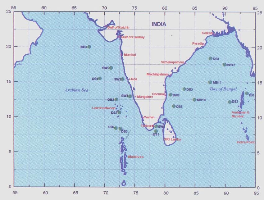
2.4.3.1 Bulletins for the high seas
These bulletins are for the shipping interests on the high seas. The area covered by these
bulletins is the sea area between the Asian Coast and the line joining the points 24oN 68oE, 20oN 68oE, 20oN
o o o o o o o o o o o o o o o o
60 E, 5 N 60 E, 5 N 95 E, 10 N 95 E, 10 N 94 E, 13 30'N 94 E, 13 30'N 92 E, 18 N 92 E and 18 N
o
94 30'E. The exact area of coverage is shown in Map A (Attachment A).
These bulletins are issued by the Area Cyclone Warning Centres at Mumbai and Kolkata and are
broadcast by the Coastal Radio Stations of the Department of Telecommunication (DoT) at Mumbai (VWB),
Kolkata (VWC) and Chennai (VWM) in morse code. The bulletins for the Arabian Sea broadcast from
Mumbai Radio are issued by the Area Cyclone Warning Centre at Mumbai, whilst those for the Bay of
Bengal, broadcast from Kolkata and Chennai Radio, are issued by the Area Cyclone Warning Centre at
Kolkata. Under the new GMDSS programme of WMO/IMO, India is issuing GMDSS bulletins for met area
VIII (N) daily at 0900 UTC and 1800 UTC with additional warning during cyclone period. These bulletins
consist of six parts. They are:
Part I : Tropical Cyclone Warning in plain language.
Part II : Synopsis of weather conditions in the forecast area in plain language.
Part III : Forecast in plain language.
Part IV : Analysis of the surface synoptic chart in IAC Fleet Code.
Part V : Data of observations from ships in WMO codes.
Part VI : Data of observations from selected land stations and upperair reports in WMO codes.
In normal undisturbed weather, two bulletins are broadcast at fixed hours known as "Daily"
bulletins. In the event of disturbed weather (depression in the Bay of Bengal and the Arabian Sea), a third
bulletin known as "Extra" bulletin is broadcast.
When a cyclonic storm has developed, three additional bulletins known as 'Storm' bulletins are
broadcast. In addition to these six bulletins, if any unexpected development of weather warrants urgent
communication to ships, a "Special" bulletin is issued which may be broadcast at any time. These bulletins
are broadcast according to a schedule at fixed hours. Daily bulletins broadcast from Mumbai and Kolkata
consist of all the above six parts, while those from Chennai consist only of Parts I, II and III. "Extra", "Storm"
and "Special" bulletins contain only Part I. An example of a tropical cyclone warning bulletin for the high
seas (Part I) is given below:
TTT CYCLONE WARNING BAY OF BENGAL 040300 UTC. SHIPS OBSERVATIONS ABSENT.
BUT SATELLITE IMAGERIES INDICATE THAT CYCLONIC STORM WITH ESTIMATED
CENTRAL PRESSURE 992 hPa LAY CENTERED AT 040300 UTC OVER WEST CENTRAL
BAY CENTRED WITHIN HALF DEGREE LATITUDE FIFTEEN DEGREE NORTH LONGITUDE
EIGHTYEIGHT AND HALF DEGREES EAST MOVING NORTHWEST AT EIGHT KNOTS.
AFFECTING AN AREA EXTENDING TWO HUNDRED NAUTICAL MILES. WIND FORCE 37
KNOTS, OCCASIONALLY INCREASING TO 47 KNOTS IN CENTRAL BAY TO A DISTANCE OF
100 NAUTICAL MILES FROM CENTRE. LIKELY INTENSIFY FURTHER AND MOVE IN NORTH
NORTHEAST DIRECTION AT 12 KNOTS AND CROSS BANGLADESH COAST BY
TH
EVENING/NIGHT OF TUESDAY THE 5 .
2007 EditionANNEX IIA7
2.4.3.2 Coastal bulletins
These bulletins give weather information in greater detail in the coastal areas for the benefit of
ships plying mainly in coastal areas. For the purpose of these bulletins, the coastal area is defined as the
sea area up to 75 km off the coastline.
As in the case of sea bulletins for merchant ships, the coastal bulletins are broadcast from Navtex,
Chennai. In normal weather coastal bulletins are broadcast twice daily (Daily One at 0630 UTC and Daily
Two at 1830 UTC respectively). These are known as "Daily" bulletins. Whenever a depression, tropical
cyclone or some other phenomenon influences the weather of the coastal strip concerned "Extra", "Storm"
and "Special" bulletins for the coastal strip are also broadcast in addition to "Daily" bulletins.
Each bulletin first gives the name of the coastal strip to which it pertains followed by the details of
the weather system, if any, affecting the coastal area. It also includes a forecast of wind, weather, visibility
and state of sea for the coastal strip. Information on storm surges/tidal waves and areas likely to be affected
are given whenever necessary. The bulletins also give information regarding storm warning signals, if any,
hoisted at the ports in the coastal strip concerned.
The coastal bulletins pertaining to Tamilnadu and Andhra coasts are being sent to Maritime telex
(Navtex) at Chennai and they are sending by Narrow Band Direct Printing (NBDP) mode to the ships plying
in the above coastal waters. Coastal weather bulletin in respect of Kerala coast is broadcast through Kochi
radio and Karnataka coastal weather bulletin is broadcast through the maritime telex (Navtex) Mumbai.
Example:
"TTT SPECIAL BULLETIN FOR ANDAMAN NICOBAR COAST. LATEST OBSERVATIONS
FROM SHIPS INDICATE THIS MORNING'S DEPRESSION NOW CYCLONIC STORM
CENTRED AT 280900 UTC WITHIN HALF A DEGREE OF LATITUDE 13oN, LONGITUDE 94oE .
LIKELY TO INTENSIFY FURTHER AND MOVE NORTHWARDS AT FIVE KNOTS. FORECAST
VALID UNTIL 281700 UTC. NORTH OF LATITUDE ELEVEN DEGREES NORTH WIND
NORTHWEST TO WEST SPEED FORTY TO FIFTY KNOTS .FAIRLY WIDESPREAD RAIN
WITH FREQUENT RAIN SQUALLS. VISIBILITY GOOD REDUCING TO VERY POOR IN HEAVY
RAIN. SEA HIGH. SOUTH OF LATITUDE ELEVEN DEGREES WIND MAINLY WESTERLY
TWENTY TO THIRTY KNOTS. SCATTERED RAIN WITH A FEW SQUALLS. VISIBILITY TEN
KILOMETRES BECOMING TWO KILOMETRES IN RAIN SEA ROUGH. LOCAL CAUTIONARY
SIGNAL NUMBER THREE HOISTED AT PORT BLAIR.”
Under the new GMDSS programme of IMO/WMO, India is issuing NAVTEX bulletins daily from the
Area Cyclone Warning Centres at Mumbai and Chennai for the respective coastal areas.
2.4.3.3 Tropical cyclone bulletins to All India Radio (AIR) for broadcast
In general, weather bulletins are issued by the meteorological offices to the AIR stations for
broadcast in the midday transmissions. These are based on 0300 UTC charts. The areas covered by the
bulletins are the areas served by the respective AIR stations. These bulletins include:
(i) a summary of the past weather;
(ii) special weather warnings for public services such as the Public Works Department,
Irrigation, DoT, Railways, etc.; and
(iii) a general forecast including warnings.
2007 EditionANNEX IIA8
Points (ii) and (iii) are valid until the morning of the second day. The summary of weather includes
information about tropical storms and depressions affecting the area. The centre of the system is included
with reference to the nearest wellknown place and latitude and longitude. Warnings in bulletins once
included are repeated in the subsequent daily bulletins also as long as adverse weather is anticipated. In
addition, meteorological centres in the maritime states include suitable warnings for fishermen. These
general bulletins are broadcast at a fixed time at midday by the AIR stations and are intended to meet the
requirements of the public in general and the needs of various categories of officials in particular.
In addition, special AIR bulletins containing cyclone alert messages issued 48 hours prior to the
commencement of the adverse weather and tropical cyclone warning messages issued 24 hours prior to the
commencement of the adverse weather in the coastal areas due to an approaching tropical storm are
broadcast. These broadcasts are meant to alert the agencies entrusted with the responsibility of carrying out
cyclone preparedness works and also the general public.
(For framing the tropical storm warning bulletins to AIR and Doordarshan abbreviated terms like "cyclone"
for cyclonic storm, "severe cyclone" for the severe cyclonic storm and "super cyclone" for super cyclonic
storm are also used.)
The height of the storm surge is included in the bulletin in metres and it represents height above
the normal tide level. The coastal districts likely to be affected by the storm are mentioned in the first
sentence of the bulletins. The types of damage likely to be expected from systems of various intensities
along with the suggested action are also included. For this purpose the following table is referred.
2007 EditionANNEX IIA9
System Intensity Damage expected Action Suggested
Fishermen advised not to venture
Deep Depression Minor damage to loose and
into the open seas.
(2833 Kts or 5261Kmph) unsecured structures
Damage to thatched huts. Breaking
of tree branches causing minor Total suspension of fishing
Cyclonic Storm
damage to power and operations.
(3447kts or 6288 kmph)
communication lines
Extensive damage to thatched roofs Total suspension of fishing
and huts. Minor damage to power operations. Coastal hutment dwellers
Severe Cyclonic Storm
and communication lines due to to be moved to safer places. People
(4863 kts or 89118 kmph)
uprooting of large avenue trees. in affected areas to remain indoors.
Flooding of escape routes.
Extensive damage to kutcha
houses. Partial disruption of power Total suspension of fishing
operations. Mobilise evacuation from
Very Severe Cyclonic Storm and communication line. Minor coastal areas. Judicious regulation of
(6490 kts or 119167 kmph) disruption of rail and road traffic. rail and road traffic. People in
Potential threat from flying debris. affected areas to remain indoors.
Flooding of escape routes.
Extensive damage to kutcha
houses. Some damage to old Total suspension of fishing
buildings. Largescale disruption of operations. Extensive evacuation
Very Severe Cyclonic
power and communication lines. from coastal areas. Diversion or
Storm ( 91119 kts or
Disruption of rail and road traffic suspension of rail and road traffic.
168 221 kmph )
due to extensive flooding. Potential People in affected areas to remain
threat from flying debris. indoors.
Extensive structural damage to
residential and industrial buildings. Total suspension of fishing
Total disruption of communication operations. Largescale evacuation
Super Cyclone and power supply. of coastal population. Total
(120kts or more or Extensive damage to bridges suspension of rail and road traffic in
222 kmph or more) causing largescale disruption of rail vulnerable areas. People in affected
and road traffic. Largescale areas to remain indoors.
flooding and inundation of sea
water. Air full of flying debris.
2007 EditionANNEX IIA10
Example:
VERY SEVERE CYCLONIC STORM SITUATED AT 181200 UTC OF DECEMBER 2003 ABOUT
250 KM SOUTH EAST OF MACHILIPATNAM LIKELY TO STRIKE COAST BETWEEN ONGOLE
AND MACHILIPATNAM IN THE NEXT 12 TO 24 HOURS.
CYCLONE WARNING:
Cyclone Warning Bulletin No. 06 issued by Area Cyclone Warning Centre, Chennai at 1900 Hrs.
IST on 18th December 2003 for repeated broadcast at hourly/half hourly intervals. Warning for Nellore,
Prakasam, Guntur, Krishna, West and East Godavari and Visakhapatnam districts. Mornings Very Severe
Cyclonic storm over westcentral Bay of Bengal moved northwestward and lay centred at 1730 hrs.1ST of
th
18 about 250kms. southeast of Machilipatnam. The system expected to intensify further and move in a
northwesterly direction and cross south Andhra Pradesh coast between Ongole and Machilipatnam by
th
midday of 19 December.
th
Under its Influence heavy to very heavy rain commencing from early morning of 19 December
likely cause floods in Nellore, Prakasam, Guntur, Krishna, West and East Godavari and Visakhapatnam
th
districts. Gales speed reaching 140150 kmph commencing from early morning of 19 December in
Prakasam, Guntur, Krishna, West and East Godavari districts. Gale force winds reaching 100110 kmph
likely Nellore and Visakhapatnam districts.
Tidal wave of five metres likely inundates lowlying areas of Prakasam, Guntur, and Krishna
districts at the time of storm crossing coast.
DAMAGE EXPECTED:
The system may cause extensive damage to kutcha houses, partial disruption of power and
communication line, minor disruption of rail and road traffic, potential threat from flying debris, flooding of
escape routes in Prakasam, Guntur, Krishna, West and East Godavari districts. And also extensive damage
to thatched roofs and huts, minor damage to power and communication lines due to uprooting of large
avenue trees, flooding of escape routes in Nellore and Visakhapatnam districts.
ACTION SUGGESTED:
Total suspension of fishing operations. Mobilise evacuation from coastal areas. Judicious
regulation of rail and road traffic. People in affected areas to remain indoors.
STORM WARNING SIGNALS:
(to be appended)
These bulletins are generally issued at the time of each sea area bulletin. The frequency of the
bulletin can be raised when the tropical storm is tracked with the help of radar and previous warnings issued
needs modification.
A third set of bulletins issued to AIR is the coastal weather bulletins. Whenever a cyclonic storm is
likely to affect the Indian coastal areas, coastal weather bulletins issued by the India Meteorological
Department are broadcast in the All India News Cycles of All India Radio from New Delhi in English, Hindi
and in the regional language of the area affected. These bulletins contain information on the following:
1) Time of issue of bulletin in IST
2) Coastal strip for which bulletin issued and period of validity
3) Position, intensity and movement of cyclonic storm
4) Forecast point and time of landfall
2007 EditionYou can also read