2012-2022 TEN YEAR MAINTENANCE DREDGING SEA DISPOSAL PERMIT FOR NEWCASTLE PORT - Long Term Monitoring and Management Plan - 04 January 2013 - Port ...
←
→
Page content transcription
If your browser does not render page correctly, please read the page content below

2012-2022 TEN YEAR MAINTENANCE DREDGING
SEA DISPOSAL PERMIT FOR NEWCASTLE PORT
Long Term Monitoring and Management Plan

Level 7, 116 Miller Street,
Sydney NSW 2060

04 January 2013
LONG TERM MONITORING AND MANAGEMENT PLAN FOR THE 2011-2021 TEN YEAR DREDGING SEA
DISPOSAL PERMIT FOR NEWCASTLE PORT

Disclaimer

This report has been prepared on behalf of and for the exclusive use of Newcastle Port
Corporation, and is subject to and issued in accordance with the agreement between Newcastle
Port Corporation and WorleyParsons. WorleyParsons accepts no liability or responsibility
whatsoever for it in respect of any use of or reliance upon this report by any third party.

Copying this report without the permission of Newcastle Port Corporation or WorleyParsons is not
permitted.

 PROJECT 301015-02409 - LONG TERM MONITORING AND MANAGEMENT PLAN FOR THE 2011-2021
 TEN YEAR DREDGING SEA DISPOSAL PERMIT FOR NEWCASTLE PORT
  REV   DESCRIPTION         ORIG           REVIEW         WORLEY-      DATE       CLIENT     DATE
                                                          PARSONS                 APPROVAL
                                                          APPROVAL

  A     DRAFT Issued for                                               7-2-11        N/A
        discussion          P Lawless      G Britton
                            K Panayotou

  B     DRAFT issued for
        TACC review         P Lawless      K Panayotou    G Britton

  C     FINAL issued to
        SEWPaC                             K Panayotou                 3-3-11
                            P Lawless                     G Britton

  D     Reissued to
        SEWPaC              O Murray       A Watters      G Britton    9-11-11

  E     Reissued to
        SEWPaC              A Watters      O Murray       A Watters    7-12-11

  F     Reissued to
        SEWPaC                                                         21-05-12
                            D Lam          AF Nielsen     AF Nielsen

  G     Reissued to
        SEWPaC                             AF Nielsen     AF Nielsen   07-08-12
                            D Lam
  REV   DESCRIPTION         ORIG           REVIEW         NPC          DATE
                                                          APPROVAL

  H     Reissued to
        SEWPaC                                                         04.01.13
                            D Lam          J Spiteri      R Sorensen

                                                Page ii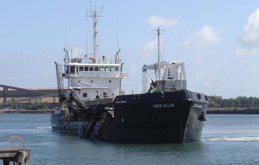
Long Term Monitoring and Management Plan for the 2011-2021 Ten Year Dredging Sea
Disposal Permit for Newcastle Port

CONTENTS
1.         INTRODUCTION ................................................................................................................ 6

     1.1   General ............................................................................................................................... 6

     1.2   Environmental Objectives ................................................................................................... 7

           1.2.1       General .................................................................................................................. 7

           1.2.2       Objectives of the LTMMP ....................................................................................... 7

     1.3   Structure and Use of the LTMMP ....................................................................................... 7

     1.4   Overall Environmental Management Framework ............................................................... 8

2.         PROJECT OVERVIEW ..................................................................................................... 10

     2.1   Dredging ........................................................................................................................... 10

     2.2   Disposal ............................................................................................................................ 13

           2.2.1       Offshore Dump Ground ........................................................................................ 13

           2.2.2       Nourishment of Stockton Beach .......................................................................... 13

           2.2.3       Temporary Storage in the Channel ...................................................................... 14

3.         STATUTORY AND LEGISLATIVE FRAMEWORK ..........................................................20

     3.1   Sea Dumping Act .............................................................................................................. 20

     3.2   Crown Lands Act............................................................................................................... 20

     3.3   Coastal Protection Act ...................................................................................................... 20

     3.4   Protection of the Environment Operations Act ................................................................. 21

     3.5   Beach Nourishment Approvals ......................................................................................... 21

4.         DESCRIPTION OF THE EXISTING ENVIRONMENT .....................................................24

     4.1   Processes and Climate ..................................................................................................... 24

           4.1.1       Tidal Hydrodynamics ........................................................................................... 24

           4.1.2       Wind ..................................................................................................................... 25

           4.1.3       Flooding ............................................................................................................... 25

           4.1.4       Turbidity ............................................................................................................... 26

           4.1.5       Offshore Wave Climate and Currents .................................................................. 26

     4.2   Maintenance Dredge Areas .............................................................................................. 27

           4.2.1       Physical and Chemical Description of Material ....................................................27

           4.2.2       Introduced Marine Organisms.............................................................................. 28

     4.3   Offshore Dump Ground .................................................................................................... 29

           4.3.1       Previous Dump Ground Use ................................................................................ 29

                                                                   Page iii                                 A375087 : Rev G : 30 January 2013
Long Term Monitoring and Management Plan for the 2011-2021 Ten Year Dredging Sea
Disposal Permit for Newcastle Port
4.3.2 Disposal Route ..................................................................................................... 29
4.3.3 Description of Dump Ground ............................................................................... 29
4.4 Fisheries ........................................................................................................................... 31
4.5 Indigenous Cultural Resources......................................................................................... 31
4.6 Non-Indigenous Cultural Resources ................................................................................. 32
5. POTENTIAL IMPACTS AND MANAGEMENT STRATEGIES .........................................33
5.1 General ............................................................................................................................. 33
5.2 Potential Impacts and Management Strategies ................................................................ 33
5.2.1 Turbidity Levels and Dispersal of Sediment ........................................................33
5.2.2 Physical Impacts at the Dump Ground ................................................................ 33
5.2.3 Sediment Quality .................................................................................................. 34
5.2.4 Effects on Marine Life .......................................................................................... 34
5.2.5 Impacts on the Water Column ............................................................................. 34
5.2.6 Air Quality............................................................................................................. 35
5.2.7 Noise .................................................................................................................... 35
5.2.8 Threatened Species and Communities ................................................................ 35
5.2.9 Changes in Bathymetry ........................................................................................ 35
6. IMPLEMENTATION OF THE LTMMP .............................................................................. 36
6.1 Introduction ....................................................................................................................... 36
6.2 Responsibilities for Environmental Management ............................................................. 36
6.3 Training ............................................................................................................................. 36
6.4 Materials to be Dumped .................................................................................................... 37
6.5 Dumping of Dredged Material ........................................................................................... 37
6.6 Record Keeping ................................................................................................................ 37
6.7 Cetacean Monitoring ......................................................................................................... 38
6.8 Introduced Marine Species ............................................................................................... 38
6.9 Sediment Sampling ........................................................................................................... 39
6.9.1 Maintenance Dredge Areas ................................................................................. 39
6.9.2 Dump Ground....................................................................................................... 40
6.10 Bathymetric Surveys .................................................................................................... 40
6.11 Spill and Waste Management ...................................................................................... 41
6.12 Reporting ...................................................................................................................... 41
6.13 Environmental Inspections ........................................................................................... 42
Page iv A375087 : Rev G : 30 January 2013Long Term Monitoring and Management Plan for the 2011-2021 Ten Year Dredging Sea
Disposal Permit for Newcastle Port
6.14 Contingency Measures ................................................................................................. 42
6.14.1 Breakdown of the David Allan .............................................................................. 43
6.14.2 Nearby Contaminated Sediments ........................................................................ 43
6.14.3 Flood Related Dredging ....................................................................................... 43
6.15 Auditing and Monitoring of Compliance with Approval Conditions...............................44
6.16 Consultation and Review of the LTMMP ...................................................................... 45
6.17 Continuous Improvement ............................................................................................. 45
6.18 Publication of the LTMMP ............................................................................................ 46
6.19 Summary ...................................................................................................................... 46
7. REFERENCES ................................................................................................................. 53
8. GLOSSARY ...................................................................................................................... 55
List of Figures
FIGURE 1.1 MAINTENANCE DREDGE AREAS
FIGURE 2.1 FLOWCHART WITH INDICATIVE TIMING OF OVERALL PROJECT
FIGURE 2.2 PROPOSED DUMP GROUND LOCATION DIAGRAM
FIGURE 2.3 TSHD DAVID ALLAN SWELL WORKABILITY PLOT
FIGURE 2.4 PROPOSED TARGET AREAS FOR GRAB DREDGING
FIGURE 2.5 PROPOSED TEMPORARY STORAGE SITE
FIGURE 4.1 WIND ROSE FOR NEWCASTLE PORT FROM UNSW (2003)
FIGURE 4.2 OFFSHORE WAVE ROSES, WAVE HEIGHT (TOP) AND WAVE PERIOD
(BOTTOM)
FIGURE 4.3 INDICATIVE AREA FROM DREDGING AREA TO DUMP GROUND
FIGURE 4.4 CONCEPTUAL MODEL FAR FIELD DISPERSION OF DREDGE MATERIAL
FIGURE 4.5 LOCATION OF ENVIRONMENTALLY SENSITIVE AREAS
APPENDIX A: NPC’S ENVIRONMENTAL POLICY
APPENDIX B: EPBC ACT PROTECTED MATTERS REPORT
APPENDIX C: NPC MATERIAL RELOCATION RECORD SHEET
APPENDIX D: NPC OPERATING LOG SHEET
APPENDIX E: SEWPAC WHALE AND DOLPHIN IDENTIFICATION GUIDE
APPENDIX F: SAP FOR MAINTENANCE DREDGE AREAS, 2011-2021
APPENDIX G: SAP FOR OFFSHORE DUMP GROUND, 2011-2021
Page v A375087 : Rev G : 30 January 2013LONG TERM MONITORING AND MANAGEMENT PLAN FOR THE 2011-2021 TEN YEAR DREDGING SEA
DISPOSAL PERMIT FOR NEWCASTLE PORT
1. INTRODUCTION
1.1 General
The Port of Newcastle is recognised as a major economic centre for both the Hunter Region and New
South Wales (NSW). It is the world’s largest coal exporting port and also has facilities to handle
general cargo, break-bulk goods and containers. Trade throughput for 2009-10 totalled 103.02 million
tonnes which was valued at $13.05 billion. The volume of trade was an increase of 7.18 million
tonnes on the previous year (2008-09).
Infrastructure within the Port includes coal terminals operated by Port Waratah Coal Services (PWCS)
and Newcastle Coal Infrastructure Group (NCIG), a bulk liquid terminal for vegetable oils, agri-food
storage and loading, local and national road and rail access and storage sheds adjacent to berths.
Much of the recent and current Port infrastructure has been constructed on reclaimed areas of
Kooragang Island or is planned for construction of remediated land in Mayfield.
In addition to shipping, the Port includes berthing for cruise liners, an 80 berth marina, the Queens
wharf entertainment precinct and a floating ship repair dock. A ferry service operates within the Port
between Newcastle and the northern suburb of Stockton.
Newcastle Port Corporation (NPC) is responsible for maintaining the declared depths of the
navigation channels and berthing boxes throughout the Port of Newcastle (refer Figure 1.1).
Dredging commenced in the Port in 1859 and has been virtually continuous since that time. Total
dredging quantities up to 1993 are estimated to have been greater than 130 million cubic metres
(Patterson Britton, 1992).
The Department of Sustainability, Environment, Water, Population and Communities (SEWPaC),
granted NPC a ten year maintenance dredging Sea Dumping Permit on 14 March 2012 which is valid
until 14 March 2022. Details of recent Sea Dumping Permits granted to NPC are shown in Table 1.1
below. The total annual volume of material dredged from the Port of Newcastle between the years
3 3
2000 and 2010 varied from 236,088 m to 444,922 m .
Table 1.1 Previous disposal permits
Date Volume Granted / Refused
3
June 2000 500,000 m per yr (maintenance) Granted (5 yr)
3
March 2001 290,000 m (capital) Granted
3
June 2006 500,000 m per yr (maintenance) Granted (5 yr)
3
June 2011 500,000 m per yr (maintenance) Granted (1 year extension)
3
March 2012 645,000 m per yr (maintenance) Granted (10 yr)
Page 6 A375087: Rev H : 04 January 2013LONG TERM MONITORING AND MANAGEMENT PLAN FOR THE 2011-2021 TEN YEAR DREDGING SEA
DISPOSAL PERMIT FOR NEWCASTLE PORT
1.2 Environmental Objectives
1.2.1 General
NPC’s environmental objectives relating to maintenance dredging activities include:
• Prevention, mitigation and management of any potential environmental impacts associated
with maintenance dredging activities;
• Ensuring that environmental management is undertaken in accordance with relevant
legislative and policy requirements, including the Sea Dumping Permit; and
• Ensuring that maintenance dredging is undertaken with due care to the environment, which
includes the promotion of environmental awareness amongst NPC employees, contractors,
customers, port users, visitors and members of the public..
1.2.2 Objecti ves of the LTMMP
LTMMPs set out both the framework and specific measures for management, mitigation and
monitoring of impacts with agreed performance criteria for specified acceptable levels of
environmental harm. The LTMMP demonstrates how the environment at the Port and surrounds will
be protected over the longer term and provides the Port with an opportunity to showcase their role as
a steward for the marine environment. LTMMPs identify responsible parties, and also include
mechanisms for the regular review of compliance with permit conditions, as well as a process for
continuous improvement of environmental management and performance over the life of the permit.
Specifically, this LTMMP incorporates details of maintenance dredging for the Port of Newcastle and
the associated disposal of the dredge spoil.. Management strategies that ensure minimal impact on
the environment have been developed for the LTMMP and are described in Sections 5 and 6.
1.3 Structure and Use of the LTMMP
This LTMMP has been prepared in accordance with draft guidelines provided by SEWPaC to enable
its utilisation as a management tool for all personnel involved in the activities associated with the sea
disposal of material derived from maintenance dredging of the Port of Newcastle. In particular, this
Plan contains an outline of:
(i) background to the project;
(ii) project proposal;
(iii) statutory and regulatory requirements for the activities;
(iv) identification of key environmental issues associated with the phases of the project;
(v) procedures for the implementation, monitoring and management of control provisions
necessary to protect the environment during the project;
(vi) responsibilities for the implementation, monitoring and management of control provisions
necessary to protect the environment during operation; and
(vii) procedures for reporting and corrective action as required.
Page 7 A375087: Rev H : 04 January 2013LONG TERM MONITORING AND MANAGEMENT PLAN FOR THE 2011-2021 TEN YEAR DREDGING SEA
DISPOSAL PERMIT FOR NEWCASTLE PORT
Items addressed in this Plan are listed in Table 1.2, with a cross-reference to where each item is
addressed in this Plan.
Table 1.2 Items Addressed in this LTMMP
Item LTMMP
Reference
Overall environmental management framework for the Port 1.4
Context of the regional and local environment, including a brief history of all 1.1
dredging and disposal activities
Information on approvals and policy context 3
Description of the dredging and disposal activities, including materials to be 2
dumped
Description of the existing environment 4
Description of potential impacts 5
Management strategies and actions 5 and 6
Contingency planning 6.14
Provisions for maintaining current sediment quality data over the life of the permit 6.9
Auditing requirements 6.15
Reporting 6.12
Continuous improvement 6.17
Stakeholder consultation, including the operation of a Technical Advisory and 6.16
Consultative Committee (TACC)
1.4 Overall Environmental Management Framew ork
NPC maintains an Environmental Management System (EMS) based on the principles of AS/NZS
ISO 14001:2004 Environment Management Systems to assist in complying with all relevant
environmental legislation, government policies and legal requirements. The scope of the EMS covers
all operations controlled by NPC in addition to operations that NPC may influence. All NPC facilities
and activities that interact with the environment are encapsulated within the EMS. The EMS is
documented, implemented, maintained and continually improved to ensure its ongoing effectiveness.
As part of this EMS, NPC has devised an Environmental Policy, which is provided in Appendix A.
The EMS also includes (but is not limited to) the following procedures:
• EMS Management Review;
• Identification of Environmental Aspects and Impacts:
• Identification of Legal and Other Requirements;
• Environmental Objectives and Targets;
• Environmental Management Programs;
Page 8 A375087: Rev H : 04 January 2013LONG TERM MONITORING AND MANAGEMENT PLAN FOR THE 2011-2021 TEN YEAR DREDGING SEA
DISPOSAL PERMIT FOR NEWCASTLE PORT
• Training;
• Environmental Incident Response and Reporting;
• Environmental Emergency Response;
• Waste Handling and Disposal;
• Monitoring and Evaluation;
• Control of Non-Conformances;
• Internal Auditing; and
• Identification of Heritage and Conservation Requirements.
• Dredging;
• Bunkering;
• Environmental Inspections;
• Fuel Tank Leak and Spill Response; and
• Identifying Significant Environmental Aspects.
Forms and work instructions contained in the EMS which are relevant to dredging activities include:
• Marine Refuelling Instructions;
• Dredge Monthly Environmental Inspection; and
• Internal EMS Audit Schedule.
This Plan has been developed in accordance with the principles of NPC’s Environmental
Management System and Environmental Policy.
Page 9 A375087: Rev H : 04 January 2013LONG TERM MONITORING AND MANAGEMENT PLAN FOR THE 2011-2021 TEN YEAR DREDGING SEA
DISPOSAL PERMIT FOR NEWCASTLE PORT
2. PROJECT OVERVIEW
2.1 Dredging
NPC undertakes maintenance dredging of the navigation channels and berthing boxes throughout the
port entrance and along the South Arm of the Hunter River. This dredging is required to remove
accumulated sediment and maintain safe, navigable depth in the Port.
The area in which maintenance dredging will be undertaken during the life of the new Sea Dumping
Permit is shown in Figure 1.1. For the purposes of the management of dredging activities, NPC has
subdivided the Port into seven areas (Areas A, B, C, D, E, F and G) based on the nature of the
sedimentation in the Port and the layout of the port area. The area in which maintenance dredging
has been undertaken to date comprises Areas A, B, C, D, E and F as represented by the blue shaded
area in Figure 1.1.
Additional berths in the Port of Newcastle will become operational during the life of the new Sea
Dumping Permit. NPC will assume responsibility for the maintenance dredging of these berths and
the adjacent shipping channel at the timings outlined in Table 2.1. A flowchart showing the indicative
timing of activities for the overall project is provided in Figure 2.1. With the exception of Dyke Berth 3
(Area B) and Mayfield 1 and 2 (Area A), these berths and the adjacent shipping channel will comprise
maintenance dredge area G, as represented by the green shaded area in Figure 1.1.
Table 2.1 Additional berths to be introduced during life of Permit
Berth Maintenance Expected timing when NPC will assume
1
Dredge Area responsibility for maintenance dredging
Dyke Berth 3 B 2013
Mayfield 1 and 2 A 2013
K10 G 2013
T4 G 2015
The maintenance dredging in Areas A, B, C, D, E and F involves the removal of material to design
dredge depths between 10.0 m and 16.5 m below Chart Datum, as indicated on Figure 1.1. The type
of material removed for maintenance purposes comprises mostly silt and clay (mud) for Areas A to D
and F with the proportion of sand being typically less than 30% by weight and often less than 10%.
The material for Area E typically comprises poorly sorted sand with less than 8% fines. Dredged
material will be derived only from the maintenance dredging of the:
• berths and port area specified as areas A, B, C, D, E and F throughout the life of the new Sea
Dumping Permit; and
• additional berths (and adjacent port areas) in area G, in addition to Dyke Berth 3 (Area B) and
Mayfield 1 and 2 (Area A), as they fall under the responsibility of NPC to maintain during the
life of the new Sea Dumping Permit (refer Table 2.1).
1
These timings are based on the best available information at the current time, although it should be noted that these timings
may change due to a range of factors. DSEWPC will be notified of any changes to the timings presented herein.
Page 10 A375087: Rev H : 04 January 2013LONG TERM MONITORING AND MANAGEMENT PLAN FOR THE 2011-2021 TEN YEAR DREDGING SEA
DISPOSAL PERMIT FOR NEWCASTLE PORT
Table 2.2 shows the total annual volume of material removed from the five maintenance dredging
Areas A, B, C, D, E and F(2012 only) over the past 12 years.
Table 2.2 Annual volume of maintenance dredge material in Port, 2000 to 2012
3
Year Total Volume of Dredged Material (m )
2000 345,287
2001 353,600
2002 379,955
2003 316,484
2004 303,826
2005 444,922
2006 342,646
2007 377,144
2008 285,533
2009 347,365
2010 236,088
2011 220,767
2012 669,968
2
Approximate Area (m ) 4,321,000
Approximate 90
Sedimentation Rate
(mm/year)
The maintenance quantities dredged from the Port have varied from year to year, due to the dynamic
and variable processes of siltation throughout the Port. The total annual volume of material dredged
3 3
from Areas A, B, C, D, E and F varied from 236,088 m to 669,968m between the years 2000 and
2012.
Annual dredge volumes from Areas G will generally increase over the life of the new Sea Dumping
Permit as additional berths fall under the responsibility of NPC to maintain (refer Table 2.1).
Anticipated dredge volumes for Area G, has been estimated as a proportion of the dredge volumes
outlined above for Areas A, B, C, D, E and F based on the total size of Area G (relative to the total
size of Areas A, B, C, D, E and F) and an estimated sedimentation rate. These volumes are
summarised in Table 2.3.
Page 11 A375087: Rev H : 04 January 2013LONG TERM MONITORING AND MANAGEMENT PLAN FOR THE 2011-2021 TEN YEAR DREDGING SEA
DISPOSAL PERMIT FOR NEWCASTLE PORT
Table 2.3 Anticipated Annual Dredge Volumes, 2011-2021
3
Maintenance Total Area Estimated Anticipated Volume (m )
Dredge Area (ha) Sedimentation
Normal Conditions Flood Years
Rate (mm/year)
A, B, C, D, E and 438 90 380,000 540,000
F
G 48 90 45,000 60,000
TOTAL 486 425,000 600,000
As outlined in Table 2.3, it is anticipated that the total average annual volume that may need to be
3
dredged from the Port in any one year in the 10 year permit could be in the order of 425,000 m , while
in any one year depending upon the occurrence of flooding events in the Hunter River, dredging
3
volumes could be in excess of 600,000 m .
In addition to the above analysis of average annual volumes, some sediment build up has been
identified on the channel batters throughout Areas A, B and D. In order to return the channel batters
3
to the design profile and allow for the occurrence of flooding events, dredging of 750,000m per
annum for a period of 3 years commencing at the start of the 10 year permit is required.
3
Therefore, in summary, in years 1 to 3 of the permit dredging of 750,000 m may be required to
remove the sediment build up on the channel batters and to allow for the occurrence of flooding
3
events, while in years 4 to 10 of the permit, dredging of 600,000 m may be required depending on
the occurrence of flooding events.
Maintenance dredging in Newcastle Port is undertaken by NPC’s dredger the David Allan. This is a
trailing suction hopper dredger which is also fitted with a grab. The vessel has a hopper capacity of
3
1000 m . Where necessary, depending on the rate of siltation in the Port, a contract dredger is
employed to supplement the work of the David Allan. This vessel would also be a trailing suction
hopper dredger. Any dredge vessel in connection with the dumping activities and any associated
vessels must comply with the relevant state, national or international standards with respect to
seaworthiness, safety and environmental requirements, or any rules or conditions laid down by the
certifying classification society, and be capable of dumping the dredged material at the dump site in
accordance with the permit.
The majority of the maintenance dredging undertaken by the David Allan is carried out in trailing
suction mode. This mode typically accounts for about 96% of all dredging. The trailing suction
method is employed in both channel areas and berth areas, but channel dredging accounts for most
of the trailer work. The typical cut depth in trailing suction mode is 0.3 to 0.4 m with a maximum of
about 1 m and minimum of about 0.1 m. The width of the drag head is 1.2 m. The width of influence
of the drag head is dependent on the material type but would be expected to be at least 3 to 4 m.
3
The grab fitted to the David Allan has a capacity of 8 m . The maximum depth of cut is about 1 m and
the minimum about 0.1 m. The typical cut height is dependent on the type of material and operating
location. Grab dredging is generally only undertaken where there is a constraint to operation in
trailing suction mode such as safety.
Page 12 A375087: Rev H : 04 January 2013LONG TERM MONITORING AND MANAGEMENT PLAN FOR THE 2011-2021 TEN YEAR DREDGING SEA
DISPOSAL PERMIT FOR NEWCASTLE PORT
2.2 Disposal
2.2.1 Offshore Dum p Ground
The dump ground off the Port of Newcastle is situated approximately 3 km south-east of Nobbys
Head in 25 to 30 m of water (refer Figure 2.2). This dump ground is the same site used for the 2006-
2011 five year permit.
The area is approximately rectangular in shape as defined by the following coordinates in WGS84:
○ ○
32 56.10’ S 151 48.94’ E
○ ○
32 55.77’ S 151 49.40’ E
○ ○
32 56.16’ S 151 49.79’ E
○ ○
32 56.49’ S 151 49.32’ E
The David Allan will track its position over the dump ground during the disposal activities to ensure
disposal is within the defined co-ordinates, using a Global Positioning System (GPS). NPC will
ensure that maintenance dredge material will only be dumped in the area specified by the above
WGS84 co-ordinates.
The David Allan generally operates one shift a day, five days per week (Monday to Friday). Up to five
3
loads per day are removed from the Port area which is equivalent to about 1200 m in situ. The
offshore disposal would continue over the 10 year period, 2011 - 2021.
During the transport of the dredged material from the dredge area to the offshore dump ground, and
on the return journey, the vessel would observe all requirements of the Harbour Master in terms of
vessel speed and other navigation requirements. Also, any appropriate maritime notices would be
issued in relation to dredging and offshore disposal activities.
The dredger would navigate along the prescribed route and once at the dump ground would open the
hopper (‘doors’ on vessel’s hull) to release the dredged material over the dump ground.
In the longer term, the fine fraction of the sediment from the dredging (sediment in the silt and clay
size fraction, i.e. mud, and some very fine sands) would be expected to disperse from the dump
ground in the manner described in previous sediment mobility studies (Patterson Britton; 1989, 1992,
2002). In these studies, the dispersion pathway of mud from the dump ground was found to be
relatively contained, bounded generally within a zone 5 km north and 6 to 7 km south of the dump
ground and out to a water depth of 60 to 100 m. The longer-term movement of dredge spoil is
primarily offshore from the dump ground into the adjacent Commonwealth Marine Area.
2.2.2 Nourishment of St ockton Beach
In addition to the Sea Dumping Permit, several other approvals are required for sea disposal including
concurrence from the NSW Minister for the Environment, who administers the Coastal Protection Act
1979, to dispose of material in the coastal zone. This is discussed in further detail in Section 3.
1
This concurrence was issued by the NSW Department of Natural Resources, which was responsible for administering the
Coastal Protection Act 1979 at this time
2
In general, approvals will be granted if it can be demonstrated that the material is suitable for the beneficial purpose of beach
nourishment and will not result in any significant environmental impacts.
Page 13 A375087: Rev H : 04 January 2013LONG TERM MONITORING AND MANAGEMENT PLAN FOR THE 2011-2021 TEN YEAR DREDGING SEA
DISPOSAL PERMIT FOR NEWCASTLE PORT
2
The conditional concurrence provided by the Minister’s Delegate, dated 30 January 2007 , excluded
maintenance dredge material from Area E (the Port entrance) from disposal at the designated
offshore dump ground, as this material had previously been shown to contain a relatively high
proportion of sand in comparison to the other maintenance dredging areas. It was preferred that
material dredged from Area E be placed off Stockton Beach for the beneficial purpose of beach
nourishment to address erosion issues along the beach.
3
An annual survey of the Port demonstrated an accumulation of up to 100,000 m of material at the
Port entrance within Area E (WorleyParsons, 2009a). If this material was not dredged, a reduction in
depth of the channel would need to be declared by NPC. In turn, this depth reduction would decrease
the loading capacity of coal vessels in the Port of Newcastle. Any disruption to NPC’s maintenance
dredging and disposal operations would therefore have a significant economic impact on Port
operations.
NPC obtained the necessary approvals for the placement of maintenance dredge material from Area
E off Stockton Beach for the beneficial purpose of beach nourishment, as described in Section 3.4. It
should be noted that this approvals process is separate to the Sea Dumping Permit application
process. Maintenance dredging in Area E was carried out in June 2010 with material placed off
Stockton Beach.
It is likely that maintenance dredging of Area E during the life of the new 10 year permit will also
involve placement of dredged material off Stockton Beach, provided that ongoing approvals are
3
obtained . Nevertheless, for completeness and flexibility, it is the intention that the new Sea Dumping
Permit will include provision for disposal of material dredged from Area E at the dump ground. If it is
determined that this material will continue to be used for the beneficial purposes of beach
nourishment, SEWPaC will be notified accordingly.
2.2.3 Temporar y Stor age in the Channel
The sea going passage of the David Allan dredge is limited by offshore swell conditions, and at times
the dredge maintains on standby within the Port until swell conditions improve. NPC proposes to
undertake dredging in difficult areas to access in the Port during these swell bound conditions and to
temporarily place the material within a suitable area within the Port channel limits for subsequent re-
dredging and offshore disposal during more favourable conditions.
This section of the LTMMP is to support NPC’s application for Ministerial approval.
2.2.3.1 C O N D T I O N S
The David Allan has a ‘swell workability’ limit relationship (refer Figure 2.3) that is used to determine
wheterh bottom dumping activities can be carried out safely in a given swell condition. The limit of
safe operation is represented by a curve that is dependant on both wave height (Hmax) and wave
period (Tp). Combinations of Hmax and Tp that fall below the curve represent conditions for which it is
safe to proceed to sea for dumping operations, combinations above the curve represent conditions for
which it is safe.
Page 14 A375087: Rev H : 04 January 2013LONG TERM MONITORING AND MANAGEMENT PLAN FOR THE 2011-2021 TEN YEAR DREDGING SEA
DISPOSAL PERMIT FOR NEWCASTLE PORT
The relationship in Figure 2.3 is used in combination with real time wave data obtained from NPC’s
offshore Waverider buoy to determine whether the David Allan is able to safely access the offshore
spoil ground or is otherwise ;swell bound’ and confined to the Port. NPC operational employees also
access forecasting information from publically available sources on the internet(e.g Bureau of
Meteorology) and obtain advice from an independent meteorologist from Newcastle University to
establish a 7 day weather forecast and plan the activities undertaken by the David Allan.
Figure 2.3 TSHD David Allan Swell Workability Limit Plot
An analysis of wave data collected from the offshore Waerider buoy from 2005 – 2011 identifies that
swell bound periods extending for a duration of greater than or equal to 4 hours occurred around 18
times per year on average during the operation hours of the dredge (6am – 6pm, 7 days a week). A
number of these swell bound periods extended over several working days with a maximum duration in
the order of 3 to 4 days.
During swell bound conditions the David Allan is unable to continue operations once its hopper is full,
and is forced to standby within in the Port until offshore conditions improve in accordance with the
swell workability limit plot (refer Figure 2.3). During normal operations the David Allan averages
around 5.5 trips to the offshore spoil ground every day (once every 2-3 hours during a 12 hour shift)
and requires around 30 – 40 minutes to carry out a return trip. As such swell bound conditions
extending for a period of over 2 to 2.5 hours are likely to result in reduced productivity of the dredge.
The adverse impact of these standby periods on the productivity of maintenance dredging and the
need to maintain design depths has led NPC to consider the means for the David Allan to continue
operating during swell bound conditions.
Reconfiguring the dredge to grab mode would require a forecast swell bound period of over 12 hours.
Swell bound conditions of this duration or greater occurred up to six times per year throughout the
record of wave data analysed between 2005 and 2011. The length of individual events extended to a
maximum period of up to 4 days.
Page 15 A375087: Rev H : 04 January 2013LONG TERM MONITORING AND MANAGEMENT PLAN FOR THE 2011-2021 TEN YEAR DREDGING SEA
DISPOSAL PERMIT FOR NEWCASTLE PORT
Therefore it is anticipated that the temporary storage site would be used around 6 times per year and
3
require the capacity to receive a maximum of around 2000 in-situ m of dredged material (i.e. 4 days
3
of production in grab mode ate a rate of 475m in-situ per 12 hour day).
2.2.3.2 P R O P O S E D L O C A T I O N S T O B E D R E D G E D D U R I N G S W E L L B O U N D
CONDITIONS
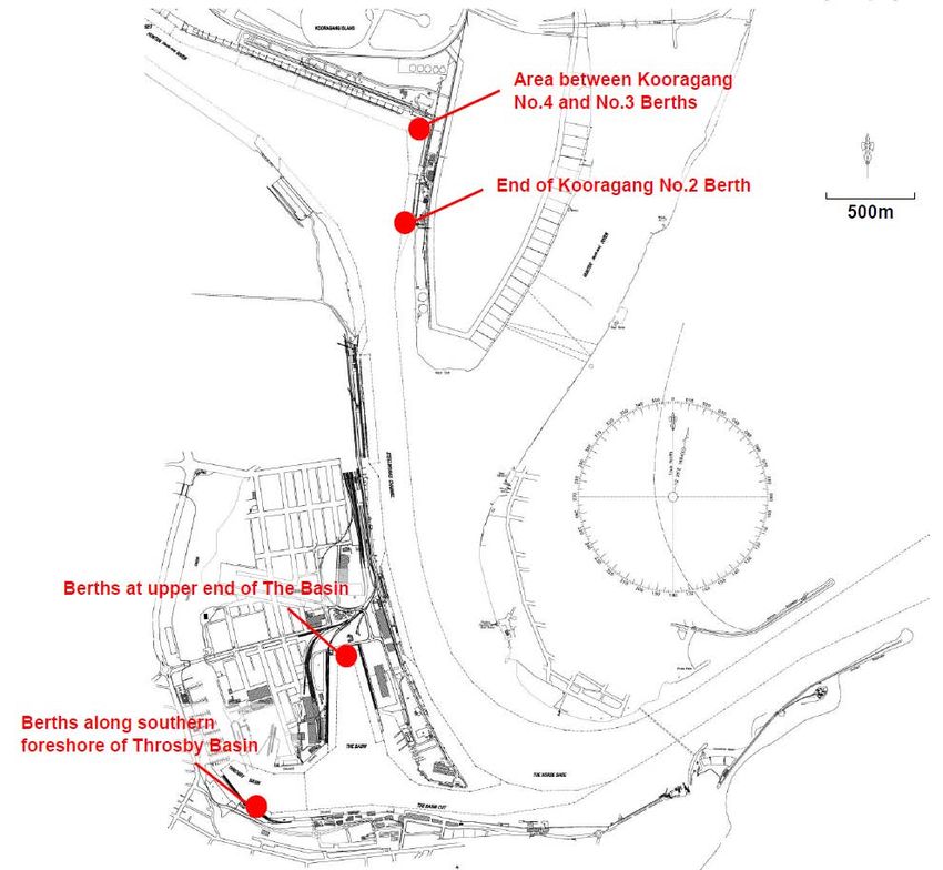
The potential areas that NPC proposes to target during swell bound periods include difficult to access
areas of berth pockets at Kooragang No.2 and No. 3, the upper end of The Basin and berths along
the southern foreshore of the Throsby Basin (refer Figure 2.4). Additional areas may be identified in
response to distribution of sedimentation and associated prioritisation of areas accessible by grab
dredging methods.
Figure 2.4 Potential target areas for grab dredging during swell bound conditions
Page 16 A375087: Rev H : 04 January 2013LONG TERM MONITORING AND MANAGEMENT PLAN FOR THE 2011-2021 TEN YEAR DREDGING SEA
DISPOSAL PERMIT FOR NEWCASTLE PORT
2.2.3.3 P R O P O S E D T E M P O R A R Y S T O R A G E S I T E
The preferred area for temporary storage of dredge material during swell bound conditions is a
depression within the existing ‘Kooragang Swing Basin’ area in the vicinity of Kooragang Berth No. 4
(refer Figure 2.5).
The site has a bed level consistently below design depth of the shipping channel (i.e. deeper that 15.2
metres below Newcastle Harbour Tide Gauge Zero [NHTGZ] datum) and would therefore have the
storage capacity to temporarily receive dredged material without adversely impacting on navigation.
Based on a recent survey undertaken by NPC, the depression in the Swing Basin areas has a
maximum depth of around 17m NHGTZ datum (1.8m below the design depth). The estimated
3
storage capacity within the area indicated in Figure 2.5 is approximately 84,000m below a level of –
3
15.2 NHTGZ (design depth) and around 38,000m below a level of -16, NHTGZ (approximate existing
bed level around the perimeter of the area).
2.2.3.4 P R O C E D U R E F O R R E - D R E D G I N G A N D D I S P O S A L O F S T O R E D MA T E R I A L
The use of the grab will enable an ‘in-situ ‘ bite to be taken from the seabed an d placed within the
dredge hopper with less water entrainment that dredging using hydraulic action in ‘trailing mode’.
Once the hopper is at its capacity, the dredge would retrieve its anchors and transport the dredged
material through the Port to the nominated temporary storage area (refer Figure 2.5). In grab mode
3
the David Allan would be able to achieve a maximum production rate of 475 insitu m per 12 hour
working day.
3
The David Allan has a hopper capacity of 1000m . If the dredge is swell bound for a number of days,
the dredge would be filled to capacity prior to disposal at the temporary placement areas in order to
reduce the number of bottom dumping events in the Swing Basin. This may involve holding the
material in the dredge overnight and recommencing grab dredging the following day.
If at the end of a day of grab dredging, the forecast indicates an improvement in swell conditions, the
dredge material would be held overnight in the David Allan and disposed of to the offshore spoil
ground the following day.
Any material placed in the temporary storage site would not be placed there indefinitely. Once
adverse sea conditions subside, the David Allan would proceed as a priority to re-dredge the
temporarily stored material, operating in its more efficient trailing mode. Re-dredging of the
temporarily stored material in trailing mode would involve less than one day of dredging, noting that in
3
trailing mode the average daily production rate is about 2500 in-situ m per 12 hour day. The material
would be transported out of the harbour for bottom dumping at the nominated offshore spoil ground
for NPC maintenance dredge material as described in Section 2.1.
3
The ten year sea dumping permit allows NPC to dredge up to 6, 450,000m of maintenance dredge
material from throughout the Port for the ten year period from March 2012, including those areas
proposed to be dredged during swell bound conditions and the area containing the temporary storage
site. All maintenance dredge material has been geochemically characterised and approved by
SEWPaC for unconfined sea disposal. NPC would re-dredge an equivalent in-situ volume of the
material from the temporary storage site.
Page 17 A375087: Rev H : 04 January 2013LONG TERM MONITORING AND MANAGEMENT PLAN FOR THE 2011-2021 TEN YEAR DREDGING SEA
DISPOSAL PERMIT FOR NEWCASTLE PORT
Figure 2.5 Proposed Temporary Storage Site
Page 18 A375087: Rev H : 04 January 2013LONG TERM MONITORING AND MANAGEMENT PLAN FOR THE 2011-2021 TEN YEAR DREDGING SEA
DISPOSAL PERMIT FOR NEWCASTLE PORT
2.2.3.5 P R O C E D U R E F O R A C C O U N T I N G F O R V O L U M E D R E D G E D A N D D I S P O S E D I N
PORT CHANNEL VERSUS VOLUMES RE-DREDGED AND DISPOSED OF AT THE
OFFSHORE SPOIL GROUND
In accordance with Condition 17 of Sea Dumping Permit SD2011/1942, NPC maintain daily records
for the time and date of each dredge run and dumping run (commencement and finishing); the
position of the vessel at the beginning and end of each run and the volume of dredge material
dumped. These records are maintained through the use of a daily vessel log and also a dredging
summary spreadsheet.
The process that will be used to account for the volume dredged and disposed in the channel versus
volumes re-dredged and disposed of at the offshore dump ground will be as follows:
The volume (in situ cubic metres) of material collected during operations in grab mode will
be recorded in the dredging summary spreadsheet separately to that collected in suction
mode. As mentioned previously (Section 2.2.3.4) this material may go to the offshore spoil
ground if conditions are within the swell workability limits (Figure 2.3).
Each time material is temporarily deposited at the specified temporary storage ground the
volume (in situ cubic metres) will be recorded in the dredging summary spreadsheet
separately to the volume of material that is deposited at the offshore spoil ground.
The spoil ground is located within Area A of the channel (ref Figure 1.1), once adverse sea
conditions subside, the David Allan would proceed as a priority to re-dredge the temporarily
stored material, operating in its more efficient trailing mode. The volume of material
dredged from the temporary storage location would be an equivalent to that placed there
during the previous temporary storage operation. The volume of material re-dredged would
be recorded in the vessel log and also in the dredging summary spreadsheet as part of the
Area A totals. A comment would be inserted on the Area A total for the day to identify the
portion derived from the temporary storage ground. The total volume deposited at the spoil
ground for the day would be recorded in the dredging summary sheet.
NPC’s vessel log also records details of weather conditions that will correlate with the use
of the temporary storage ground records maintained in the dredging summary sheet.
As per Condition 10 of SD2011/1942 nominees of the department will be granted access to witness,
inspect, examine or audit any part of the operations. NPC will ensure that all records are maintained
in a clear, accurate and traceable manner at all times.
Page 19 A375087: Rev H : 04 January 2013LONG TERM MONITORING AND MANAGEMENT PLAN FOR THE 2011-2021 TEN YEAR DREDGING SEA
DISPOSAL PERMIT FOR NEWCASTLE PORT
3. STATUTORY AND LEGISLATIVE FRAMEWORK
3.1 Sea Dumping Act
The Environment Protection (Sea Dumping) Act 1981 provides for the environmental assessment of
the dredging and disposal of dredged material in Australian waters. Commonwealth approval from
SEWPaC is required under the Environment Protection (Sea Dumping) Act 1981 for the dredging and
disposal at sea of maintenance dredged material from the Port of Newcastle.
Under the Environment Protection (Sea Dumping) Act 1981 SEWPaC issued NPC with Sea Dumping
Permit SD2011/1942 on 14 March 2012. The permit allows NPC to dump up to 6,450,000 cubic
metres of sea bed material derived from maintenance dredging in the Port of Newcastle..
3.2 Crow n Lands Act
Under the Crown Lands Act 1989, administered by the NSW Minister for the Environment, a license
for dredging and disposal of dredge material on Crown land is required. The license for maintenance
dredging only pertains to that part of Area E beyond a line joining the position of mean high water
mark at the outermost points of the northern and southern breakwaters, as this defines the boundary
between NSW Maritime channel ownership (for which all maintenance dredging approvals are in
place) and Crown land further offshore. A licence for the sea disposal of the maintenance dredge
material is also required as the dump ground is located on Crown land inshore from the three nautical
mile limit of Coastal Waters in NSW.
NPC was granted licences under the Crown Lands Act 1989 from the Minister for the Environment for
their maintenance dredging and disposal operations on 6 August 2009 (Licence Numbers RI 450958
and RI 450488 respectively). Licence RI 450958 is valid until revoked, licence RI 450488 has expired
on 31 December 2012 and has since been replaced with new Licence RI 500434, dated 01 January
2013. This licence has been granted for a period of ten years in line with the ten year Sea Dumping
Permit.
3.3 Coastal Protection Act
The Coastal Protection Act 1979, administered by the NSW Minister for the Environment does not
have application to maintenance dredging within Newcastle Port since the Coastal Protection
Regulation 2004 removes the need to obtain the concurrence of the Minister to carry out development
4
on any estuary that forms part of the coastal zone.
However, the Coastal Protection Act 1979 does have application to the sea disposal operations as
the disposal ground is located inshore from the three nautical mile limit of Coastal Waters in NSW.
NPC has been granted concurrence under the Coastal Protection Act 1979 from the Minister for the
th
Environment for their maintenance dredging and disposal operations on 10 July 2012, which is valid
until 30 June 2017. NPC will request ongoing concurrence from the Minister as required during the life
of the new 10 year permit.
4
‘estuary’ includes any part of a river whose level is periodically or intermittently affected by coastal tides
Page 20 A375087: Rev H : 04 January 2013LONG TERM MONITORING AND MANAGEMENT PLAN FOR THE 2011-2021 TEN YEAR DREDGING SEA
DISPOSAL PERMIT FOR NEWCASTLE PORT
3.4 Protection of the Environment Operations Act
The Protection of the Environment Operations Act, 1997 (POEO Act) is the primary Act regulating
pollution control and waste disposal in NSW. The Act gives the NSW Office of Environment and
Heritage (OEH) the authority to issue licences and environment protection notices. Under the POEO
3
Act, dredging of more than 30,000 m per year is classified as a scheduled activity and an
environment protection licence (EPL) is required. Accordingly, NPC hold a current EPL (number
th
3373) for their maintenance dredging program. This licence has a Review Due Date of 5 September
2013 and will be amended as required during the life of the new 10 year permit.
3.5 Beach Nourishment Approvals
As noted in Section 2.2.2, the approvals process for the placement of maintenance dredge material
from Area E off Stockton Beach for the beneficial purpose of beach nourishment is separate to the
Sea Dumping Permit application. In a letter to NPC dated 9 July 2009, the Department of
Environment, Heritage, Water and the Arts (DEWHA), now SEWPaC, confirmed that a permit under
the Environment Protection (Sea Dumping) Act 1981 is not required for the placement of dredged
sand off Stockton Beach for the purpose of beach nourishment as this activity is genuinely for a
purpose other than the mere disposal of material. SEWPaC does however require notification of the
activity occurring and that the material will not be disposed of at the disposal ground; and requires
verification that the material from Area E is clean and of similar nature to the material at Stockton
Beach.
Dredging of uncontaminated material from Area E and its placement off Stockton Beach fall under
Part 5 of the Environmental Planning and Assessment Act 1979 (EP&A Act) and requires preparation
of a Review of Environmental Factors (REF) or, depending on the potential environmental impact, an
Environmental Impact Statement (EIS).
The following is a summary of the approvals that were obtained before the maintenance dredging in
Area E and placement of dredged material off Stockton Beach was undertaken in June 2010:
• Crown Lands Act 1989 – Licenses for dredging and placement of dredge material on Crown
land (Licence Numbers RI 450958 and RI 450488 respectively) were granted by the Minister
on 6 August 2009. Licence RI 450958 is valid until revoked while licence RI 450488 has
been replaced with Licence RI 500434 for a period of ten years in line with the sea dumping
permit. Further renewals will be sought as required during the life of the new 10 year permit
• Coastal Protection Act 1979 – Concurrence was granted by the Minister for the Environment
3
on 7 July 2011 for the maintenance dredging of up to 150,000 m of material from Area E and
the disposal of the material offshore of Stockton Beach. This concurrence is valid until 30
June 2015. Further concurrence will be obtained as required during the life of the new 10 year
permit.
• Protection of the Environment Operations Act 1997 – Dredging and placement activities
associated with the nourishment of Stockton Beach are also bound by the conditions set out
in EPL number 3373.
• Fisheries Management Act 1994 – Notification to the Minister of Primary Industries was given
and issues raised by the Minister were considered during formulation of the project proposal
and preparation of the REF.
Page 21 A375087: Rev H : 04 January 2013LONG TERM MONITORING AND MANAGEMENT PLAN FOR THE 2011-2021 TEN YEAR DREDGING SEA
DISPOSAL PERMIT FOR NEWCASTLE PORT
3.6 Temporar y Storage Approvals
Existing Approvals
Maintenance dredging has been carried out on an almost continuous basis since dredging
commenced in the Port in 1859 (WP, 2009a). The maintenance dredging and the offshore disposal of
the material at the designated spoil ground are approved under a Commonwealth 10 year sea
dumping permit and are managed via a long term monitoring and management plan (as described
above). NPC also hold a NSW environmental protection licence (EPL) for the dredging within the
Port.
As NPC’s maintenance dredging activities pre-date legislation such as the EP&A Act and EP&A
Regulation, an environmental assessment, such as a REF, has not been completed for the Port’s on-
going maintenance dredging activities. However, for activities outside the usual maintenance
dredging and offshore disposal activities, environmental assessments have been undertaken by NPC
and approvals sought. Specifically, in addition to this REF for the temporary placement of dredge
material within the Port during swell bound conditions, an REF was prepared for the Area E Port
entrance dredging and beach nourishment activities.
NSW Planning and Approvals
The statutory basis for planning and environmental assessment in New South Wales is set out in the
Environmental Planning and Assessment Act 1979 (EP&A Act) and the Environmental Planning and
Assessment Regulation 2000 (EP&A Regulation). The proposal, as an activity, would be undertaken
under Part 5 of the EP&A Act. In accordance with the requirements of the Act a Review of
Environmental Factors (REF) has been prepared and submitted to Newcastle Port Corporation as the
determining authority for the activity.
Licences and Approvals
Roads and Maritime Service (RMS) is the owner of the bed within Newcastle Port. As such, NPC is
required to obtain land owners consent from RMS. Upon receiving the Part 5 approval this along with
a copy of the REF will be submitted to RMS.
Relevant additional State Legislation that applies to the activity is as follows:
• Protection of the Environment Operations Act 1997 (POEO Act) – Environmental Protection
Licence
An Environment Protection Licence (EPL) from the NSW Environment Protection Authority (EPA) is
3
required for the dredging of more than 30,000 m per annum. NPC currently holds an EPL for the
3
dredging (L3373) for > 500,000 to 2,000,000 m of water-based extractive activities.
Page 22 A375087: Rev H : 04 January 2013LONG TERM MONITORING AND MANAGEMENT PLAN FOR THE 2011-2021 TEN YEAR DREDGING SEA
DISPOSAL PERMIT FOR NEWCASTLE PORT
The EPA has advised that as the project does not fall into the definition of a scheduled activity for the
purposes of the POEO Act, it does not legally require an EPL. The project falls within NPC’s existing
licence requirements for dredging activities.
• Fisheries Management Act 1994 (FM Act), Clause 199 - Notification to the Minister for Primary
Industries
Whilst no formal approval is required for the proposed activities under the FM Act, in accordance with
Clause 199 of the FM Act, NPC as a public authority, is required to provide notification to the Minister
administering the FM Act prior to undertaking or authorising any dredging work. NPC is also required
to consider any matters raised by the Minister.
Commonwealth Legislation
An EPBC Act Protected Matters Search was undertaken using a 5km buffer around the Port.
Following review of the search results, it was considered that the proposed temporary storage and re-
dredging of maintenance dredge material would not significantly impact on matters of NES or the
environment. Therefore, referral to the Minister and approval under the EPBC Act is not considered
to be required.
The proposed temporary storage of sediment within the Port is to be undertaken wholly inside waters
within the limits of the State and is regulated by State legislation, i.e. does not require approval under
the Environment Protection (Sea Dumping) Act 1981. However, the re-dredging of the material for
the purpose of sea disposal is regulated under the EPSD Act and therefore issues raised by
SEWPaC were considered in the REF. A letter issued by Department of Sustainability, Environment,
Water, Populations and Communities (SEWPaC) on 23 November 2012 stated that the re-dredging of
the material would not require a variation to NPC’s current Ten Year Sea Dumping Permit issued by
th
the Minister on 14 March 2012 but would require amendment of this LTMMP to include the
proposed temporary storage activity and approval of the amended LTMMP by SEWPaC.
Page 23 A375087: Rev H : 04 January 2013LONG TERM MONITORING AND MANAGEMENT PLAN FOR THE 2011-2021 TEN YEAR DREDGING SEA
DISPOSAL PERMIT FOR NEWCASTLE PORT
4. DESCRIPTION OF THE EXISTING ENVIRONMENT
4.1 Processes and Climate
4.1.1 Tidal Hydrod ynami cs
In general, in non-rainfall periods, astronomical tides are the major factor affecting the hydrodynamics
of the Hunter River. As applies to the NSW coast in general, the tides acting at the entrance to the
5 6 7
estuary are semidiurnal (with significant diurnal inequality ), with a strong spring-neap cycle
(Patterson Britton & Partners, 2003). The tidal variation levels at Newcastle Harbour in the vicinity of
the project proposal are provided in Table 4.1.
Table 4.1 Tidal Level Variation in Newcastle Harbour from GHD (2003)
8
Tidal Plane Level (m NHTG)
Highest Recorded Tide 2.37 m
Highest Astronomical Tide 2.10 m
Mean High Water Springs 1.62 m
Mean High Water 1.49 m
Mean High Water Neaps 1.37 m
Mean Sea Level 0.99 m
Mean Low Water Neaps 0.62 m
Mean Low Water 0.49 m
Mean Low Water Springs 0.37 m
Tides in the Hunter estuary vary from the ocean entrance to the tidal limits, generally with a gradual
reduction in the mean tidal range proceeding upstream (excluding slight amplification within the
Williams and Paterson Rivers). The tidal limit in the Hunter River is approximately at Oakhampton (64
kilometres upstream from the ocean. The general reduction in tidal range moving upstream can be
understood in terms of tidal excursion, the distance a water particle travels over a tidal cycle. In the
lower estuary, the tidal excursion is about 10 kilometres (MHL, 2002).
5
Semi-diurnal tides have high and low water approximately equally spaced in time and occurring twice daily (that is, on
average, there are two high tides and two low tides in any 24 hour period).
6
Diurnal inequality is the difference in height of the two high waters or the two low waters of each tidal day.
7
Spring tides occur twice per month (during new or full moons) and result in higher high tides and lower low tides (that is, a
larger tidal range, compared to the average). Neap tides also occur twice per month (during quarter moons) and result in lower
high tides and higher low tides (that is, a smaller tidal range, compared to the average).
8
The Newcastle Harbour Tide Gauge (NHTG) Datum is operated by the Port of Newcastle which is approximately the lowest
astronomical tide level and is 1.01 m below Australian Height Datum (AHD).
Page 24 A375087: Rev H : 04 January 2013You can also read