Water Management in the Netherlands
←
→
Page content transcription
If your browser does not render page correctly, please read the page content below
Rijkswaterstaat
                                                                                    Water Management
                                                                                    in the Netherlands

                                              Water Management in the Netherlands

This is an edition of

Rijkswaterstaat

For more information visit
www.rijkswaterstaat.nl
Telephone +31 (0)800 - 8002
(toll free number, in the Netherlands only)

February 2011 | wd0111vv007b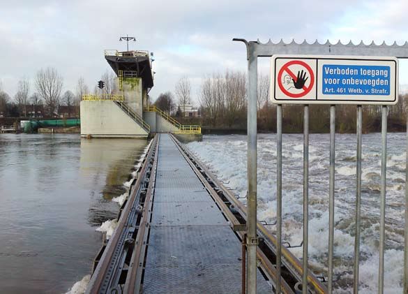
2 | Rijkswaterstaat
Water Management
in the Netherlands
2 | Rijkswaterstaat
Preface
Having the right amount of water for water users, at the right time, in the
right place, and at socially acceptable costs is one of the key targets for the
Ministry of Infrastructure and Environment.
Today’s ground rules for the distribution of water in the Netherlands
originate from the 1980s, more specifically from the second Policy
Document on Water Management. At the time, the entire water
infrastructure was reviewed. The conclusion was that large-scale
investments in the water infrastructure were not necessary and that good
management would suffice to optimise the benefits of our water
distribution system.
Our infrastructure and the ground rules still suffice, but the capabilities
have been stretched to the limits. Climate change and sea level rise prompt
a re-examination of our water management. The resilience of the main
water system, the water infrastructure and the ground rules are up for
reconsideration. Water usage has also changed and new facilities are
needed. We can only respond to the forecasted climate changes if we are
fully conversant with the way the main water system works. The question is,
are we still familiar with the background, the operation and the rules of our
water management? This booklet seeks to contribute to answering that
question. This is also an excelent opportunity to offer our collegues from
abroad an overview of the specific situation of water management in the
Netherlands, a country that would not be inhabitable without our flood
defences and water management structure.

I hope you will enjoy reading it.

Luitzen Bijlsma
General Director, Rijkswaterstaat, Centre for Water Management

                                                                 Water Management in the Netherlands | 3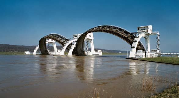
4 | Rijkswaterstaat
Preface                                                                    3

  Introduction                                                               7

1 The development of water management in the Netherlands                    11
  The history of the formation of the Netherlands                           11
  The history of water management in the Netherlands                        13

2 System and functioning                                                   21
  Management of the freshwater element of our water management system      22
  Components of our water management system:                               26
  – The Meuse                                                              26
  – The Rhine and its distributaries                                       27
  – IJsselmeer area                                                        31
  – Southwestern Delta                                                     31
  – Regional waterways                                                     36
  Limits to water management                                               36

3 Safety                                                                   37

4 Excess of water                                                          41

5 Water shortages and drought                                              47

6 Salinisation                                                             53

7 Water quality                                                            59

8 Future developments                                                      65
  Physical and societal changes                                            65
  Consequences of climate change for water management                      69

9 Towards ‘climate-proof’ water management                                  71

10 The Water Act and its legal instruments                                 75

  Publication information                                                  80

                                                     Water Management in the Netherlands | 5
6 | Rijkswaterstaat
Introduction
Water management in the Netherlands is a complicated issue. Also,water
distribution throughout the country is far from straightforward. The
challenges for water policy makers are significant and the discussions about
these challenges frequent. That is precisely why it would be practical if
the parties involved could share an unequivocal body of knowledge and
a vocabulary that everybody understands.

As the work of many water management authorities and water users is
usually limited to only one part of our water system, it is often difficult to
understand the system as a whole and all its interconnections. There is
also sometimes a distorted perception of the possibilities that exists in
channelling water. The need to have an overview of our water management
system and its functioning is indispensable in present discussions. It is
important to know why things are organised the way they are and to
understand the aspects closely related to the distribution of water, such as
safety, excess of water and shortages, drought and salinisation. It is also
important to know which issues and bottlenecks to expect if climate
change persists.

This booklet describes water management and water distribution in the
Netherlands as well as the problems related to flooding, water shortages,
safety, drought and salinisation. The description of our water management
system includes a short history of the geological creation of the Netherlands
and an account of the interventions that took place over the centuries to
protect the country from highvolume river discharges or storm tides.
Land reclamation and other hydraulic engineering projects, such as the
excavation of channels to the sea and the canalisation of rivers, are also
briefly discussed.

We also look at water distribution, focusing on the main water system,
the regional system and the interaction between them. Water distribution
under normal circumstances is distinguished from water distribution in
the event of flooding or water shortage.

                                                           Water Management in the Netherlands | 7
The relation with safety and salinisation is explained as well. Finally,
we discuss the current bottlenecks and the problems we can expect as
a consequence of climate change and soil subsidence. Where relevant,
the various themes will be related to the designated users.
This booklet may be used by everyone involved in organisational issues
of water management in the Netherlands: water management authorities
and policy staff of municipal councils, provinces, water boards and central
government, as well as people who use our water system, and other
interested parties. The aim is to provide basic knowledge on water
management and water distribution in the Netherlands. Hopefully this
knowledge and information will contribute to a clear discussion on solving
current and future bottlenecks. We hope it will also contribute to insight
and understanding of those abroad, who are interested in the particularities
of water management in the Netherlands.
8 | RijkswaterstaatWater Management in the Netherlands | 9
10 | Rijkswaterstaat
1 The development of
watermanagement in
the Netherlands
The history of the formation of the Netherlands
At the end of the last Ice Age, around 10,000 years ago, the North Sea was
a large lowland plain. As temperature increased the sea level rose and after
a few thousand years, the North Sea was on the doorstep of what we now
call the Netherlands. River water came to a halt behind barrier bars that
the sea had created. Silt settled and plants flourished in the warmer climate,
forming a layer of peat on windborne sands deposited during the previous
period.
For centuries these layers of peat accumulated, particularly where the
barrier bars formed a continuous line, as it did in Holland. However, storm
tides washed away entire areas of peat, after which marine clay deposits
were formed. This happened mostly in the southwest of the Netherlands.
In the east and south the coarse and fine sand deposits from the ice ages
still occur on the surface. Here we also find the hilly areas of the Veluwe,
the Utrechtse Heuvelrug, the Hondsrug and Salland, which are formed
by lateral moraines left behind by the ice ages. These high grounds are
criss-crossed by a multitude of streams that provide natural drainage.
In the north we also find boulder clay.
Water Management in the Netherlands | 117000 BC 5500 BC
This mixture of boulders, gravel and loam was so heavily compacted by the
glaciers of the last ice age that it became impermeable, which has its effect
on today’s water management.
12 | RijkswaterstaatThe history of water management in the Netherlands
Living on the edge of land and water offers many benefits, which is why our
ancestors stayed here despite the intrusive sea, trying to learn to live with
water. Excavations near Vlaardingen in the late 1990s proved that water
management was already part of life before the Common Era began.
Dams, sheet piling and culverts were uncovered that are clearly indicative
of water management interventions. People in the north erected artificial
dwelling mounds called terps several centuries before the Common Era
began.
Gradually, we became more enterprising. The Middle Ages saw the
reclamation of the peat bogs. Channels and ditches were dug from the
levees into the elevated bogs in order to drain them. As an unintended
effect, exposure to air caused the bogs to set and oxidise.
While this was a slow process, in time the surface level dropped until it
lay beneath the level of the river on the other side of the levee. Dikes and
mills became necessary to drain the excess water into the rivers.
In the southwest, the bogs were not drained but excavated for their salt
deposits. This type of surface level reduction gave easy access to the
sea: large parts of the bog were washed away, for instance during the
St. Elisabeth Flood of 1421, which created the Biesbosch. Large estuaries
were formed around the cores of islands.
In the north, this had already happened several centuries before. Here the
sea had breached the barrier bars in 1170, washing away the bog situated
behind them, and thus creating an internal saltwater lake: the Zuiderzee.
Shortly afterwards, in the 13th century, the inhabitants of the salt meadows
in Groningen and Friesland decided to link the mounds or ‘terps’ on which
they lived by building a series of dikes.
Even after the Middle Ages, sea levels continued to rise and land continued
to subside. Dikes had to be raised continually. But water management at
times also took the offensive: in the early 17th century, we started draining
the lakes and ponds that had been created by extracting peat. The last of the
inland lake reclamation projects, Haarlemmermeer, was drained around
1850. By then, powerful steam-driven pumping stations had been developed
that enabled us to drain this large lake.
Water Management in the Netherlands | 13Soil map of the Netherlands: high grounds with wind-borne sand deposits drain into low-lying
grounds with Holocene deposits.
14 | RijkswaterstaatDiking in the southwest and north (the Dollard) reclaimed large stretches
of land from the sea, undiscouraged by disastrous setbacks in the form of
periodic storm surges. The area along the major rivers of the Netherlands was
also subject to regular flooding, often caused by ice dams: ice floes snagged
on the shore, impeding subsequent floes until the blockage became so great
that the water forced its way over or through the dikes.
In the course of the 17th century, the Waal became the main distributary of the
Rhine. Almost 90 percent of the Rhine’s water discharged through the Waal
to the sea. This drastically reduced the discharge of the Rhine itself and of its
other branch, the IJssel. In order to stop this process, as well as for military
and socio-economic reasons, the Pannerdensch Kanaal was dug in 1707.
The succession of evermore powerful water-related interventions resulted in continual
subsidence of low-lying areas of the Netherlands, while the sea level continued
to rise ever faster (mean sea level [m.s.l.]).
Water Management in the Netherlands | 15Arnhem Arnhem
Pannerdensch Kanaal
Aerdt Aerdt
Pannerden Pannerden
Lobith Waal Lobith
Waal
Schenkenschans Schenkenschans
How the Pannerdensch Kanaal restored the discharge through the Neder-Rijn and IJssel.
In the 18th century, the rivers started to have difficulties discharging into
the sea. The Maasmond at Brielle silted up and shallows were also formed
upstream. Yet it would still be another century before this was corrected by
river intervention works.
The 19th and 20th centuries saw more drastic interventions, such as the
digging of the Nieuwe Merwede, the Bergsche Maas and the Nieuwe
Waterweg, and the construction of weirs in the Neder-Rijn designed to
create a different distribution of the Rhine’s water over its distributaries.
The Netherlands earned international renown with the Zuiderzee Project,
which began with the Afsluitdijk (1927-1932) and the reclamation of the
Wieringermeer, the Noordoostpolder, Oostelijk Flevoland and Zuidelijk
Flevoland. Equally impressive is the Delta Project, built in response to the
disaster that hit the southwest Netherlands in 1953. The Delta Project in
particular confirmed our reputation as controllers of the sea, especially
once the planned dam in the Oosterschelde was altered in such a way that
the sea will only be kept out if there is the threat of a repeat of the 1953
disaster.
Many of the interventions, however, have a downside which we only
started to understand in retrospect such as, for example, the ecological
consequences of the Delta Project. This understanding was incorporated
into the integrated water management policy launched in the 1980s.
Meanwhile, all these interventions have caused us to forget that the sea
actually intended to continue shifting our coastline further eastwards.
Where it would have ended up by now is difficult to say.
16 | RijkswaterstaatSouthwestern Delta below sea level (dark blue). Right: situation in the event of flooding;
left: situation in the event of flooding if no interventions had been made in our water system.
The intrusion of the sea would have been counteracted by the rivers,
which would have continued building up their deltas. But evidently
the Netherlands would have looked very different had these interventions
not taken place.
Fact is that the coast now lies where it is. And that we decided in 1990 to
try and maintain the coastline there. This is why we have been so busy ever
since with sand replenishments, both on the beach, the foreshore and in
the littoral zone. Moreover, at the turn of the millennium some events
occurred that turned our views on water management upside down. High
discharge volumes from the rivers Rhine and Meuse in 1993 and 1995 led to
the Space for the River programme. In addition, exceptional droughts in
2003 and early 2005 underlined the importance of designating areas where
water can be stored as a buffer capacity.
Water Management in the Netherlands | 17Water Boards
In the early Middle Ages, the western part of the Netherlands was a boggy
peatland. For people to work and live on that land, it had to be drained.
In those days, the villagers did that themselves by digging a ditch, building
a dam or constructing a dike. From the 11th century onwards, this gradually
changed. The people who owned the land were often no longer villagers
but large landowners who lived in cities, castles or estates. Moreover,
there was a growing insight that the construction of dikes and water
drainage were matters that went beyond the realm of a village.
In the 13th century, people with common interests in safe water
management formed co-operatives, resulting in the first water boards.
Their co-operation not only involved working together, it also implied
participation in governance, which makes the water boards the oldest
form of democratic government in the Netherlands. The water board
Hoogheemraadschap van Rijnland, established in 1232, is the oldest water
authority that is still in function.
There used to be several hundred water boards, but in the last century
their number has been reduced considerably. Nowadays there are 26 left.
Rijkswaterstaat
At the end of the 18th century, parliament decided to establish a powerful
central organisation to prevent the country from being flooded by the sea
and rivers. Shipworms were attacking the wooden seawalls and
quaysides, harbour mouths were silting up, and ice dams were causing
flooding. Countermeasures were taken, but they often only provided
solace on a very local scale and caused new problems elsewhere. It was
time for centralised water management on a national level. On March 27,
1798, an ‘Agency for Public Works and Water Management’ was
established, comprising a president, an assistant and a draughtsman.
Nowadays Rijkswaterstaat is the implementing agency for the Ministry of
Infrastructure and Environment. Rijkswaterstaat administers the national
road network (3,260 km), the national waterways network (1,686 km) and
the water system (65,250 km2), including the Dutch part of the North Sea.
The legal instruments at the diposal of our water authorities are
presented in chapter 10.
18 | RijkswaterstaatOverview of the area administered by the 26 regional water boards.
Water Management in the Netherlands | 19Bifurcation point (‘T-junction’) at IJsselkop, seen from the south.
The ship is approaching from the IJssel.
20 | Rijkswaterstaat2 System and
functioning
The Netherlands could be considered as a gateway for water. All the water
that is carried across its borders by streams and rivers must be discharged
into the sea. The same applies for rainwater, which makes its way to the sea
overland or underground. In the east and south, this happens naturally.
Due to the relief of the land, water on high ground finds its own way down.
But in the flat low-lying areas that also lie below sea level, water needs a
helping hand.
We gradually tried to turn this gateway into a control panel: a pumping
station here, a lock there, dams, dikes and weirs everywhere. This has
resulted in a mosaic of rivers, canals, lakes and (dammed) estuaries,
interlaced with a system of ditches, town canals and channels. Generally we
manage the operation of our main water system quite well. We direct water
from the Rhine and Meuse to locations of our choice. A substantial amount
is stored in Lake IJsselmeer, so that it can be used later on for the
production of drinking water, irrigation purposes and much more. We make
sure that there is sufficient water in the canals to allow shipping to continue
and we use it to combat saline intrusion of groundwater and to keep
seawater at bay.
Water Management in the Netherlands | 21Management of the freshwater element of our water
management system
However small our country is, it still is part of four international river
basins: Rhine, Meuse, Scheldt and Ems. All the water that flows down
these rivers passes through our country on its way to the Wadden Sea and
the North Sea.
As this booklet focuses only on the freshwater element of these river basins
and on the transitional area (the southwestern Delta), the Scheldt and Ems
will not be discussed. The discussion of our water management system will
address the following:
• rivers with accompanying canals in the same river basin,
• IJsselmeer area,
• southwestern Delta, and
• the smaller, regional waterways on high grounds and in low-lying areas.
In order to understand how our water management system works, the water
systems themselves need to be explained. A water system comprises various
components which interconnect to a high degree, particularly in the water
management system of the Netherlands. They influence each another, they
are co-dependent and moreover they are sensitive to transfer of problems
related to water quality and quantity. To understand that
interconnectedness properly, this paragraph will first describe the nature
and character of the various components.
Water from high grounds flows to the sea as surface water as well as via groundwater streams.
22 | RijkswaterstaatHigh grounds
Rain that falls onto high grounds partly infiltrates where it fell, while the
remainder flows to lower-lying areas by way of streams. The infiltrated water
also seeps down, which causes marshland to develop at the foot of the high
grounds. These areas react differently in summer and winter. In summer,
the groundwater level is low as a result of the evaporation surplus, which
causes the ground to absorb most precipitation, and run-off is limited.
In winter, the soil is saturated and rainwater is discharged immediately.
River
A river can be fed by meltwater, precipitation and groundwater. In summer
(with zero or only a small precipitation surplus and little meltwater),
the river stream is narrow. In times of a large precipitation surplus and/or
a lot of meltwater, the river can become so wide as to cover the entire flood
plains (the area between the summer dike and the winter dike).
The ‘river system’ component.
Polder
A polder is an area that is protected from outer water by a dike and that has
a controlled water level on the inside of the diked area. Any water entering
the polder (rain, seepage water) that is not used or stored, has to be pumped
out. To do this, the water is first pumped into the polder outlet.
Water Management in the Netherlands | 23Lay-out of our water management system. 24 | Rijkswaterstaat
Diagram of the components ‘polders’ and ‘reclaimed land’.

Streams between components
The different components (high grounds, polders and rivers) cannot be
seen in isolation from one another. There is constant interchange:
the river supplies water to the lake, the lake discharges water into the sea
and the polder drains water into the lake, as well as absorbing it in the
summer. The water level in the lake influences the seepage water and
groundwater flows. In short, everything is interconnected.

Interconnectedness
This interconnectedness is the basis for management of our main water
system. Under normal circumstances, it seams obvious that water in every
component is at the level we want it to be and that it flows where it is
needed. However, in periods of excess rainfall in our own country and in
countries upstream, or during prolonged periods of drought, we have to
constantly control and manipulate the system to continue serving all
water-related interests. We do this according to scenarios and agreements,
which will be discussed in detail in the following paragraph.

                                                            Water Management in the Netherlands | 25
The interconnectedness of the water system components.
Components of our water management system
Rivers and canals
The days when the rivers could determine their own course are long gone.
We have taken various measures to control water distribution.
Key tools are the weir at Driel, which determines to some extent how much
Rhine water flows to the IJssel, the Neder-Rijn and the Waal; the sluice gates
in the Afsluitdijk, which enable us to regulate the water level in Lake
IJsselmeer; and the Haringvliet and Volkerak sluice gates, which allow us
to determine through which ‘exit’ the water will flow into the sea.
The Meuse
The Meuse is a rain-fed river and, as a result, it often goes through periods
with little discharge. In order to retain what water there is and to maintain
shipping, seven weirs were constructed in the 20th century: at Borgharen,
26 | RijkswaterstaatLinne, Roermond, Belfeld, Sambeek, Grave and Lith. They are almost always
in operation, being opened only when the discharge volumes are high.
This mostly occurs in winter, when there can be so much rainfall in the river
basin that the Meuse cannot cope with this discharge. This happened,
for example, in 1993 and 1995.
Where the Meuse crosses the border at Eijsden, it is almost immediately
divided into three channels: the Zuid-Willemsvaart, the Julianakanaal and
the Grensmaas (the stretch of Meuse in the border region of the Netherlands
and Belgium).
In the Grensmaas, we aim at a minimum flow of 10 m3/s for ecological
reasons, but in dry periods this cannot be maintained. Shipping along
the Julianakanaal must remain possible at all times, requiring 20 m3/s to
compensate for losses at the locks at Born and Maasbracht. In dry periods,
water that is used through operation of the locks is pumped back again.
The canals in Midden-Limburg and Noord-Brabant
The provinces of Limburg and Noord-Brabant rely on the Meuse for their
water supply. According to several treaties with Belgium since 1863,
the Netherlands is obligated to discharge a minimum of 10 m3/s into the
Zuid-Willemsvaart via the supply culvert at Maastricht. In return, Belgium
is obligated to redirect 2 m3/s, plus anything exceeding the obligatory
10 m3/s that is discharged to the Netherlands at Lozen. Incidentally, part
of the Meuse water is already diverted near Liege, which Belgium uses to
supply the Albertkanaal.
Water management of the canals in Midden-Limburg and Noord-Brabant
is laid down in a water agreement that aims to ensure that the supply and
discharge of water is distributed equally among the areas managed by the
regional water boards.
The Rhine and its distributaries
The Rhine crosses the Dutch border at Lobith. The first bifurcation point
is near the Pannerdensche Kop. Here the river splits into the Waal and the
Pannendersch Kanaal, which flows into the Neder-Rijn.
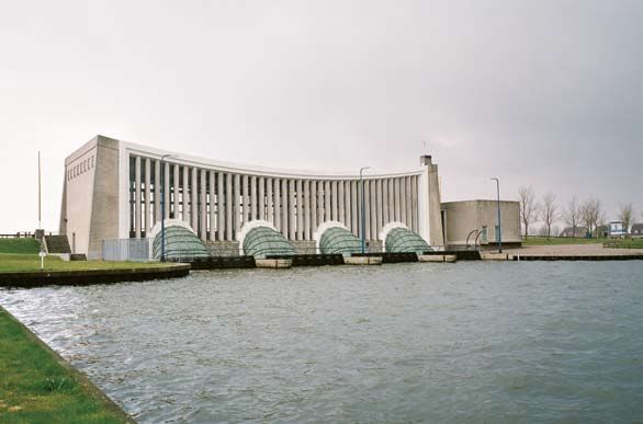
East of Arnhem, the IJssel branches off from the Neder-Rijn. The weir in
the Neder-Rijn near Driel is operated in such a way that Rhine water can be
discharged into the IJssel for as long as possible at 285 m3/s and that there
is always 25 m3/s left for the Neder-Rijn. The remainder goes to the sea
through the Waal.
Water Management in the Netherlands | 27Detail of the subsystem of the Meuse and the canals in Midden-Limburg and Brabant.
This distribution of water discharge guarantees a reasonable navigation
depth on the three river branches. In addition, the power station Harculo
near Zwolle receives sufficient cooling water and there is enough water
available in Lake IJsselmeer to meet agricultural requirements in the north
of the Netherlands during dry periods.
This ideal scenario can be maintained on average for at least nine months
per year. However, if the discharge at Lobith is less than 1,300 m3/s, it is
impossible to direct 285 m3/s to the IJssel. Even so, a discharge of 25 m3/s
is still maintained over the Neder-Rijn.
28 | RijkswaterstaatCatchment area of the subsystem of the Amsterdam-Rijnkanaal and Noordzeekanaal.
Green drains directly, yellow indirectly
As the discharge rises above 1,300 m3/s, the weirs at Driel, Amerongen and
Hagestein are gradually opened and the discharge through the Neder-Rijn
increases, while approximately 285 m3/s continues to flow through the
IJssel. If the Rhine has a discharge over 2,400 m3/s, the weirs are fully
opened and the distribution of water discharge can no longer be
manipulated.
The Amsterdam-Rijnkanaal and the Noordzeekanaal
The Amsterdam-Rijnkanaal and the Noordzeekanaal are of major
importance for shipping connections between IJmond, Amsterdam
and Germany and for regional water management. The canals must be
considered as a single system. The map shows the catchment area for
this system. The green area is drained directly, the yellow area can also
be drained indirectly through the Noordzeekanaal by way of the inlet
Oranjesluizen (locks) near Schellingwoude. On average, 60 percent of the
water in the system is supplied by regional water discharged by the water
boards (the green area). The system drains into the North Sea at IJmuiden.
When the sea level is low, the water flows through discharge sluices
Water Management in the Netherlands | 29(maximum 500 m3/s). When the sea level is high, the IJmuiden pumping
station, which is the largest in Europe (maximum 260 m3/s), is put into
operation.
Water can be supplied through locks at Wijk bij Duurstede and
Schellingwoude. The quantity supplied by Lake IJsselmeer depends to
a large extent on the flushwater management for the Lake Markermeer.
The amount that is supplied at Wijk bij Duurstede in dry periods in its turn
depends on the amount of water that can be subtracted from the Waal at
Tiel, as the discharge in the Neder-Rijn is needed to maintain the water
levels downstream.
Water is withdrawn from the Amsterdam-Rijnkanaal and the Noordzeekanaal,
for regional water supply and drinking water purposes.
This is taken into account in the management of the system as navigable
depth is to be maintained. If the level of Lake Markermeer permits flushing
of the Vecht and water supply via Muiden, water can also be directed into
the Amsterdam-Rijnkanaal. In that case, less water has to be diverted from
the Waal through the Neder-Rijn.
Many ships are locked at IJmuiden. This causes saltwater to flow into
the Noordzeekanaal, creating a saltwater gradient from IJmuiden to the
connection with the Amsterdam-Rijnkanaal. Ecologically, this saltwater
gradient provides the Noordzeekanaal with unique ecological characteris-
tics. Because there is an inlet point for drinkingwater in the Amsterdam-
Rijnkanaal we must ensure that saltwater incursion does not advance any
further. To that end, a minimum flow of approximately 30 m3/s is aimed
for at Diemen. If possible, water from Lake Markermeer is also used at
Schellingwoude to halt saltwater incursion.
In prolonged periods of drought, water from the Amsterdam-Rijnkanaal is
also used to combat salinisation of the polders in the province of Zuid-
Holland. During dry periods water from the Hollandsche IJssel is too saline
for this purpose, because the saltwater tongue has advanced too far into the
Nieuwe Waterweg. This arrangement to provide the polders in the province
of Zuid-Holland with water from the Amsterdam-Rijnkanaal was made in
the late 1980s in a Water Agreement entitled Small-scale Water Supply
Provisions. It stipulates that a system of pumps and pumping stations direct
approximately 7 m3/s of freshwater to the polders of Zuid-Holland during
periods of water shortage.
30 | RijkswaterstaatIJsselmeer area
This water system comprises lakes IJsselmeer, Markermeer, IJmeer and
Randmeren. This is the largest freshwater basin in Western Europe and
functions as a buffer which, during periods of drought, can supply water
to many of the northern parts of the Netherlands.
It is also a nature reserve of national and international importance.
Its primary function is to discharge water from the river basins of IJssel,
Overijsselse Vecht and Eem.
Lake IJsselmeer – and in the summer months, Lake Markermeer – is
primarily fed from the IJssel. From April to September, the target level on
these lakes is 0.20 m below mean sea level (m.s.l.), while during the
rest of the year a level of 0.40 m below m.s.l. is maintained. There is
usually enough water to maintain this level. In the winter months,
Lake Markermeer discharges the majority of its excess water into Lake
IJsselmeer, while in the summer most of it flows westwards to flush the
Noordzeekanaal. In spring and autumn the direction of the water discharge
changes depending on the weather conditions and the water levels.
Excess water from Lake IJsselmeer is discharged into the Wadden Sea via
sluice gates at Den Oever and Kornwerderzand.
Lake IJsselmeer provides significant water volumes to the provinces of
Friesland and Groningen, as well as the northern part of Noord-Holland
and large parts of Drenthe and northwest Overijssel. In addition, water inlet
points for the production of drinking water are located at Andijk and
Enkhuizen. However, the quantities involved here are relatively small.
The key water inlet points for the Schermerboezem are located on Lake
Markermeer at Lutje-Schardam, Schardam and Monnickendam. Finally,
water from Lake IJsselmeer can be let in at Muiden and Zeeburg to flush the
Vecht and the Amsterdam canals, respectively. During periods of drought,
a sequence of priorities comes into operation (see page 52), which
determines the order in which the scarce supply of water will be allocated to
the users. For the IJsselmeer area this sequence has been laid down in the
regional sequence of priorities entitled ‘Water distribution in the Northern
Netherlands’.
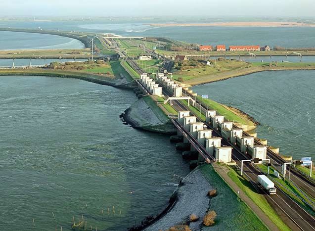
Southwestern Delta
The southwestern Delta is demarcated by the Nieuwe Waterweg/Nieuwe
Maas, the Biesbosch and the Scheldt estuary. It is a complex system of
interconnected and mutually influential fresh- and saltwater waterways.
Water Management in the Netherlands | 31Detailed map of the southwestern Delta.
Some waterways are stagnant, others are tidal.
The Rhine, Meuse and Scheldt converge here. Water distribution is largely
regulated by the Haringvliet sluice gates, which are operated in such a way
that the Nieuwe Waterweg can discharge 1,500 m3/s for as long as possible.
In this way, we attempt to counteract saltwater incursion and prevent
salinisation of the Hollandse IJssel, the most important water inlet point
for the mid-western part of the Netherlands of which is located at Gouda.
Moreover, the operation of the Haringvliet sluices aims to ensure a
minimum water level in the Hollandsch Diep of 0 metre Amsterdam
Ordnance Datum (NAP), in order to sustain navigation to and from the
seaport of Moerdijk.
During discharges at Lobith up to 1,100 m3/s, the Haringvliet sluice gates
are completely closed, except for the salt drains and fish passages.
When the Rhine discharge is between 1,100 and 1,700 m3/s, the gates are
open at low tide for 25 m2 if the sea water level is lower than the water level
32 | Rijkswaterstaaton the landward side. In this way, an average flush rate of some 50 m3/s
per tide is maintained in the western part of the Haringvliet.
At discharge rates between 1,700 and 9,500 m3/s, the sluice gates are
gradually opened and at discharge volumes over 9,500 m3/s, the gates are
fully opened. However, these operation rules are not always sufficient to
maintain a target discharge of 1,500 m3/s at Hoek van Holland. During
periods of low flows and when the Haringvliet sluices are completely closed,
the Nieuwe Waterweg receives the discharges from the Lek, the Waal and
even the Amer, minus the water that is drained at the Volkerak sluice gate
and the flush rate of the Haringvliet.
At the moment, the Haringvliet sluice gates still form a solid barrier
between the sea and the Haringvliet, and as such they block the passage of
(migratory) fish such as salmon and trout. The Haringvliet sluice gates will
be left ajar in 2010 in order to create a more natural delta. This means that
the gates will no longer close during rising tides, but will remain ajar on
the condition that the freshwater inlet points do not become salinated.
In this way, a gradual transition from seawater to river water will develop.
Moreover, migratory fish will be able to pass through the sluice gates.
This measure is in line with the implementation of the Water Framework
Directive and the Bird and Habitat Directives (Natura 2000).
With the excavation – and subsequent deepening – of the Nieuwe Waterweg
to ensure access to the port of Rotterdam, saltwater moved further and
further inland, which compromised the water supply to Delfland. To supply
fresh water to Delfland, a pipe with a capacity of 4 m3/s was installed from
the Brielse Meer to Delfland, passing underneath the Nieuwe Waterweg.
In combination with the existing capacities for leading 10 m3 through the
Lopikerwaard or Krimpenerwaard, the area can now meet its own water
demands.
Water Management in the Netherlands | 33Lake Volkerak-Zoommeer was created in 1987 as a result of the decision
to keep the Oosterschelde in an open connection to the sea.
To retain sufficient tidal range, the surface area of the Oosterschelde
was reduced with the help of the Philipsdam and the Oesterdam. By
disconnecting the Lake Volkerak from the Haringvliet and flushing the
system with freshwater from the Hollandsch Diep and the rivers in
the province of Brabant a fresh water lake was created.
Since 1994, excessive amounts of nutrients and a long retention time in
this lake have created optimal conditions for blue-green algae blooms.
Blue-green algae adversely affect the aquatic environment by producing
toxins. In addition, when they die off in late summer, they produce a
terrible smell. This causes inconvenience to residents, holiday-makers and
tourists almost every year, while farmers cannot use freshwater from the
lake for irrigating their crops. In 2004, a study was initiated to identify
solutions to this problem. The research results led to the conclusion that
the necessary improvement in water quality cannot be obtained if Lake
Volkerak-Zoommeer remains a freshwater lake. Only if the lake is
salinated again and limited tidal dynamics are restored, water quality
will improve sufficiently for the algal blooms to disappear.
34 | RijkswaterstaatOverview of all ‘water valves’ in the main water management system.
Water Management in the Netherlands | 35Regional waterways
In addition to the main water system, there is also a dense network of
ditches, streams and canals in the Netherlands that belong to the regional
water system. The main water system and the regional water systems are
interconnected at several locations. In the event of excessive rainfall, the
regional system drains into the main system, while the regional system can
be fed by the main system in periods of drought.
In low-lying parts of the Netherlands, the water that enters the system has a
variety of functions, the most important of which is maintaining the water
level to prevent subsidence of peat bogs. In addition, flushing is used to
guarantee good water quality. In higher areas, the water is supplied
primarily for irrigation purposes. The map on page 35 provides an overview
of the ‘water valves’ in the main and regional systems.
Limits to water management in the event of extreme
discharge volumes
Under normal circumstances, our water system works well.
Problems such as safety, water shortages, flooding, waterlogging and
salinisation usually only occur under extreme circumstances. The fact that
problems occur is no surprise given that the margins for water distribution
in and between the various elements of the system are small. In the event of
extremely low river discharges, every weir along the Neder-Rijn is opened
and the sluice gates on the Haringvliet and Afsluitdijk remain closed, but
that is all we can do to regulate or direct the distribution of water. The same
is valid for extremely high discharges, when we can do nothing else but
open all the sluice gates as wide as possible.
The following chapters deal with safety, flooding, water shortages and
drought, salinisation and water quality in the current situation.
Chapter 8 provides a glimpse into future developments and their potential
consequences, and Chapter 9 discusses the policy and management
documents that indicate how we intend to adapt our water management
system to climate change effects.
36 | Rijkswaterstaat3 Safety
Dunes, dams, dikes and the Delta Project enable us to live safely in our
low-lying country. The standards that the water defences have to meet are
laid down by law. Ironically, the gradual development of the system with
which we gained control over the water created a safety risk in itself. River
water that is forced to remain in a limited space between dikes can only rise
in the event of higher discharge rates.
We have exchanged as it were the inconvenience of a large area of wetland
for a virtual guarantee of land that is permanently dry, but at the risk that
water levels will be much higher than before in the event of a flood. This
threat has increased even more by subsidence and sea level rise. As the
population behind the dikes has grown and investments in housing and
businesses run into the billions, the consequences of a dike burst would be
disastrous. In the distributaries of the Rhine, water distribution relates to
safety in yet another way. The ‘regulatory valves’ in the main system are
operated in such a way that the chance of flooding is equally high in all
distributaries. Management and maintenance of the river beds and winter
beds must ensure that this continues to be the case.
Water Management in the Netherlands | 37What is safety?
Dikes and dunes ensure that we may feel safe. All the dunes and the most
important dikes are called primary water defences, because they protect us
from flooding by the sea, the main rivers or Lake IJsselmeer and Lake
Markermeer. The secondary defences are also important, but if a dike in this
category collapses, the consequences are not as dramatic – although the
inhabitants of Wilnis may think differently. There, the ring dike of the
Groot-Mijdrecht polder burst in August 2003 and the streets in the Veenzijde
estate were covered by half a meter of water. Yet, in terms of safety, Wilnis is
of a different order than what we are discussing here. If the primary water
defences were breached, the consequences would be considerably greater,
Just how safe we are behind the water defences depends on where we live.
The Flood Defences Act indicates the safety standards for every dike ring
area. The standard is higher if more economic activities take place within
the ring and if the number of inhabitants is high. Other important factors
are the size of the area liable to flooding; the height to which the water may
rise and whether the flood water will be fresh or saline.
The standard is expressed in a probability per year that a critical water level
will occur, e.g. 1:1,250 per year. The requirements for a flood defence
structure in terms of height and strength are derived from that standard.
38 | RijkswaterstaatHow is safety determined?
The safety of lakes, rivers, the river delta and the sea are each determined
by different factors:
Lakes water level, wind (wind action and wave run-up)
Rivers water discharge and, to some extent, wind
(wind action and wave run-up)
River delta river inflow, sea level, wind (wind action and wave run-up)
Sea tide and wind (wind action and wave run-up)
Safety, for whom?
The Delta Committee, established after the disaster of 1953, has laid down
our current protection policy. However, since then, a number of issues have
changed. Considerable investments were made in the areas behind the
dikes and the number of people living there has increased significantly.
These developments are not likely to stop any time soon. In addition, all
climate scenarios forecast by the Royal Netherlands Meteorological Institute
(KNMI) show a rise in sea level and river discharge volumes. In short, the
threat and the potential consequences of a flood are on the increase.
A large-scale flooding will cause widespread damage and long-term
disruption of our society.
That is why there is growing support for an alternative approach to safety.
We should no longer focus on the probability of a failure of our water
defences, but on the risk (i.e. probability multiplied by consequences)
of actual flooding. This provides greater insight into the possibilities of
limiting the consequences of flooding. The riskbased approach shows that,
despite all our efforts, the risk can never be reduced to zero. By implication,
the national government cannot be held solely responsible for protection
against flooding. However, the preventive approach of high-water
protection remains pre-eminent in water management policy. In order to
map the risks of flooding, the government, provinces and water boards are
implementing the programme Flood Risks and Safety in the Netherlands.
For each dike ring, the probability of flooding and the flood damage is
expected to be mapped out by 2010 – taking the present situation as the
basis for calculating probabilities.
Water Management in the Netherlands | 3940 | Rijkswaterstaat
4            Excess of Water

A cellar full of water is upsetting. A layer of water on the road is a nuisance.
No more and no less. In any case, our safety is not at risk.
We have caused part of the problem ourselves, by gradually paving or
asphalting more land and continually choosing to build residential estates
at locations where water also likes to ‘reside’ now and again. The National
Administrative Agreement on Water (NBW) includes an agreement that
water management must be in order by 2015, indicating how often flooding
or waterlogging may occur.

What is excess of water?

Excess of water is the collective term for situations in which we are faced
with large amounts of water in the form of precipitation or groundwater,
but without it endangering our lives. In most cases, the problem is
temporary, such as after a heavy rainstorm or flooding.

Excess of water caused by rain
Heavy rainfall occurs mostly between September and March. This is also
the period when the rivers carry more water. Excess of water that occurs as
a combined effect usually affects low-lying areas, where the water gathers

                                                             Water Management in the Netherlands | 41
and from where it is difficult to pump out because of high water levels.
The same is valid for polders. In salt meadows, the problem is worse
because the water also comes up through the ground.
Excess of water caused by groundwater
In areas with high groundwater levels, excess of water can occur whenever
there is insufficient drainage and the water gets into crawl spaces or
basements. A frequent problem is spontaneous seepage under dwellings,
which is difficult to solve without drainage or pumps.
What is waterlogging?
Waterlogging is a specific term used for a state of the soil whereby the water
content in the soil prevents enough aeration for specific activities. Ground
may be regarded as waterlogged when the water table of the ground water
is too high to conveniently permit an anticipated activity, like agriculture.
Waterlogging can also be cased by excessive rainfall.
Overview of interconnected causes of flooding.
42 | RijkswaterstaatWhat causes water flooding and waterlogging?
Flooding and waterlogging are caused by:
• insufficient ability to store rainwater; reasons include more intensive use
of land, increase of paved surfaces, reduced storage capacity.
• the excessive level of outer waters, making it impossible to drain water
swiftly from the upstream area which leads to stagnation.
• alterations in spatial layout. Sometimes we built residential areas at
locations that used to be storage basins. In that case, higher groundwater
levels alone can cause damage.
• subsiding ground levels caused by shrinkage, setting and oxidation of
peat bogs. The result is that water level and ground level more rapidly
coincide with one another. In addition, the height difference between
groundwater and surface water in higher-lying waterways or lakes
increases, resulting in more seepage water.
As for regional waters, flooding occurs when water levels are so high that
the streams, lakes or waterways bursts their banks. In the main water
system, floods are deemed to occur if national waterways are not sufficiently
capable of storing or discharging regional water discharges. Given that
national waterways are the final link in the discharge chain, it is important
that they are not the weakest links, otherwise they will cause excess of water
in upstream regional water systems. On the other hand, it is equally
undesirable that regional water boards should shift their drainage problems
onto the national waterways. Agreements between water authorities
concerning such matters are laid down in so-called water agreements.
National waterways can cause flooding and waterlogging in two ways.
Directly, when water flows over its banks, and indirectly, when high water
levels on national waterways block discharges from regional waters.
There are different causes of flooding and waterlogging in polders, on high
ground, in urban areas and in areas between the rivers and the dikes.
Water Management in the Netherlands | 43Weir in the Neder-Rijn at Driel.
Polders
In polders, excess of water can be caused by:
• limited storage capacity, which means that water cannot be collected
• overly rapid discharges into storage basins, that cause these to overflow
• insufficient drainage capacity to pump water to larger storage basins.
This causes problems if large amounts of water need to be drained and/or
if the receiving water has a high level and the discharge head increases
• extra seepage water caused by high water levels behind the dike, which
causes waterlogging.
High ground
On high ground, flooding and waterlogging are caused by:
• stagnation in discharges due to high water levels downstream or in
receiving waters
• overly rapid discharges, resulting in increasing water discharge levels.
This increase is temporary, because the water then flows to low-lying
areas.
Urban areas
Floods caused by rainfall often occur in cities or industrial estates, where
almost all rainfall drains into the sewer. This is usually a combined sewer for
waste water as well as rainwater, even though segregated sewer systems for
separate rainwater discharges are gaining ground. During heavy rainfall,
sewers cannot cope with the amount of water and overflow, resulting in
44 | Rijkswaterstaatstreets being flooded. Much worse, sometimes cellars are flooded as well.
Moreover, if a combined sewer overflows, public health may become an
issue.
Areas outside the dikes
In areas outside the dikes, floods are simply caused by high water levels.
It is sometimes necessary to accept excess of water. If the operation of the
main system requires ‘closing the tap of the regional drainage system’, local
flooding will occur. This will, however, prevent potentially less controllable
flooding elsewhere and thus jeopardizing safety.
Who is affected by floods?
In order to determine whether the systems operate as they should, it is
necessary to know the requirements for water systems.
Management goals have been set for this: a particular water level must not
be exceeded more than once in a certain period of time. An assessment of
whether the system is functioning properly does not so much focus on the
extent to which the level is exceeded but on the frequency with which this
occurs and, particularly, for how long.
Regional water boards assess their water systems according to the operating
standards stipulated in the National Administrative Agreement on Water,
on the basis of which they can determine whether measures are required to
keep damage due to flooding and waterlogging at an acceptable level.
The operating standards indicate how often flooding is allowed to occur
statistically. Different standards apply for different designated land uses.
Grassland, for example, may be waterlogged once every 10 years, land on
which greenhouses are built only once every 50 years and in built-up areas
flooding is not to happen more than once every 100 years.
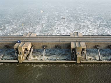
Water Management in the Netherlands | 45Weir in the Meuse at Roermond. 46 | Rijkswaterstaat
5            Water shortages
             and drought

Even this boggy land near the sea experiences water shortages once in a
while. That is to say, freshwater shortages. The very dry summer of 2003
and the dry spring of 2005 are the most recent examples.
Plants withered in the fields, ships could only be partially loaded, power
stations were limited in their intake of cooling water, nature suffered from
drought. In order to prepare for the next period of drought, the “sequence
of priorities” – which indicates the order in which water will be allocated
to specific users – was adjusted.

What is water shortage and drought?

We speak about drought when there is a long-term shortage of areaspecific
water, which causes every process that is dependent on the water cycle to
suffer. Drought manifests itself in a shortage of moisture in the soil’s root
zone, in extremely low water levels in rivers, and even in dry waterways.

                                                           Water Management in the Netherlands | 47
What causes a water shortage?
A water shortage can be caused by a severe lack of rainfall or low river
discharges. The lack of sufficient infrastructure to supplement the shortage
in rainfall may also be a cause. Occasionally, available water is not properly
distributed. Finally, the water can be of inferior quality: too saline
(for agriculture, drinking water and industrial processes), too warm
(to be used as cooling water) or too polluted.
Aside from all this, shortages can arise even when there is no drought,
simply because demand exceeds supply.
Who is affected by water shortages?
Water shortages manifest themselves in three ways. A shortage of moisture
in the soil is most common. This means that there is not enough water for
plants, stunting their growth. Secondly, a shortage can occur in the surface
water, meaning that water levels cannot be sufficiently maintained. This
results in a lack of water for agricultural purposes and flushing. The inability
to maintain water levels can have a negative effect on the stability of dikes,
engineering structures and foundations. Bogs can become oxidised. In the
third place, a consequence of insufficient water of the correct temperature
and quality is that power stations have no cooling water, drinking water
companies have to close their inlet points and farmers and horticulturalists
cannot irrigate their crops.
The diagram besides features drought regions and their characteristic
drought-related problems.
48 | RijkswaterstaatNorthern Netherlands
Salinisation along the Wadden Sea coast, drought-related problems on the islands.
Northeastern Netherlands
Dry areas due to a lack of water supply infrastructure.
Centraleastern Netherlands
Groundwater related drought.
Supply from the IJssel and the Vecht in cases of drought.
Eastern Netherlands
Presence of hilly areas where
water supply is impossible.
Central Netherlands
Shortage of cooling water in the
Amsterdam-Rijnkanaal/ Noordzeekanaal,
no other drought-related problems.
Northwestern Netherlands
Few drought-related problems,
occasional deficiencies of the
water supply system.
Western Netherlands
Salinisation and small-scale water supply.
Southwestern Netherlands
Salinisation.
Southeastern Netherlands
Presence of hilly areas where water supplyis impossible.
Supply from Germany and Belgium.
Southern Netherlands
Water shortage in hilly areas where water supply is impossible. Dependent on water supply from
Belgium, though no agreements exist to that end. In dry periods, therefore, the water supply is
significantly limited.
Area around the major rivers of the Netherlands
Few drought-related problems, occasional deficiencies of the water supply system.
Water Management in the Netherlands | 49sufficiently maintained. This results in a lack of water for agricultural
purposes and flushing. The inability to maintain water levels can have
a negative effect on the stability of dikes, engineering structures and
foundations. Bogs can become oxidised. In the third place, a consequence
of insufficient water of the correct temperature and quality is that power
stations have no cooling water, drinking water companies have to close
their inlet points and farmers and horticulturalists cannot irrigate their
crops.
Shortages are sometimes characterised by large regional variations.
Differences in soil moisture can be due to meteorological conditions,
soil type, land use, management of surface water levels and seepage water.
Shortages in surface water are mostly down to limited possibilities in
freshwater supply. In the downstream river areas, this is directly related
to salt incursion.
A shortage of water affects almost every sector:
Agriculture
Water shortages lead to lower production. Crop yields can be down by 10
percent in an average dry year. However, this does not necessarily equate to
economic damage. Damage caused by salinisation only accounts for one
percent of the overall drought-related damage. This is due to heavy flushing
and to the fact that farmers and horticulturalists opt for drought-related
damage rather than salt damage. A substantial part of the losses caused by
water shortages are the indirect result of choosing to prevent moisture
damage. By opting for deep drainage, farmers and horticulturalists
implicitly accept that they will sometimes lose crops due to water shortages.
Shipping
Low water levels mean that ships can carry less cargo. These limitations
become relevant if the Rhine’s discharge level falls below 1,250 m3/s.
This occurred recently in 2009.
Energy sector
Production is usually limited once every two years. However, the reason
for this is high river water temperatures rather than low discharge levels.
50 | RijkswaterstaatNature
Choices in spatial development and subsequent adjustments to water
management have occasionally created artificial situations that have made
ecosystems vulnerable to drought. Moreover, fragments of nature already
suffering from drought are facing even harder times as they barely have any
reserves to draw on.
How do we respond to periods of drought and water
shortages?
Periods of drought can sometimes last so long that it is no longer possible
to serve every designated use. This forces us to choose: who or what takes
priority in the distribution of scarce supplies of river water? This choice is
not made all over again each time but criteria are laid down in a ‘sequence
of priorities’. These priorities were drawn up in response to the exceptional
drought of 1976, and updated after the summer of 2003 when drought was
almost as intense (see box on page 52).
Unfortunately for shipping and the other sectors in category 4 the water
level in rivers, canals and harbours is the least of our concerns when water
is in short supply. If needs be, farmers and horticulturalists who cultivate
capital-intensive crops and factories using process water (category 3) are
also ignored, so as to allocate only water to the production of drinking
water and to power stations (category 2). Ultimately, all that remains are
the interests of the first category: safety and the prevention of irreversible
damage.
Water Management in the Netherlands | 51You can also read