Hydrology of Central Florida Lakes -A Primer - In cooperation with the ST. JOHNS RIVER WATER MANAGEMENT DISTRICT SOUTH FLORIDA WATER MANAGEMENT ...
←
→
Page content transcription
If your browser does not render page correctly, please read the page content below
Hydrology of
                            Central Florida Lakes
                                       —A Primer

In cooperation with the                     U.S. Geological Survey
ST. JOHNS RIVER WATER MANAGEMENT DISTRICT            Circular 1137
SOUTH FLORIDA WATER MANAGEMENT DISTRICT
U.S. DEPARTMENT OF THE INTERIOR
                         BRUCE BABBITT, Secretary

                            U.S. GEOLOGICAL SURVEY

                           Mark Schaefer, Acting Director

The use of firm, trade, and brand names in this report is for identification purposes only and
                  does not constitute endorsement by the U.S. Government

                  U.S. GOVERNMENT PRINTING OFFICE : 1998

                              Free on application to the
                               U.S. Geological Survey
                            Branch of Information Services
                                      Box 25286
                              Denver, CO 80225-0286

                   Library of Congress Cataloging-in-Publication Data

           Schiffer, Donna M.
                Hydrology of central Florida lakes : a primer /
             by Donna M. Schiffer : illustrations by Rafael Medina.
                   p. cm. — (U.S. Geological Survey circular : 1137)
                “In cooperation with the St. Johns River Water Management District
             and the South Florida Water Management District.”
                Includes bibliographical references.
                Supt. of Docs. no.: I 19.42: 1137
                1. Lakes—Florida. I. St. Johns River Water Management District.
             II. South Florida Water Management District. III. Title.
             IV. Series.
             GB1625.F6S35 1997
             551.48'2'09759—dc21                                         97–822
                                                                            CIP

                                                            ISBN 0–607–88561–0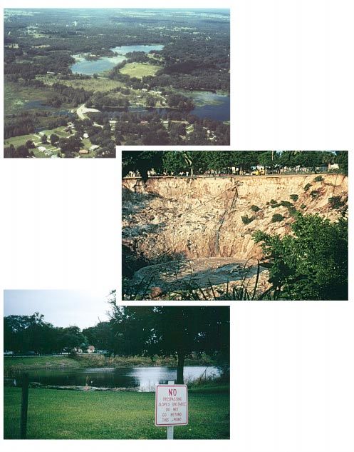
CONTENTS
Introduction ...........................................................................................................................................................................    1
Classification of Lakes ..........................................................................................................................................................          4
The Hydrologic Cycle ...........................................................................................................................................................            5
      Rainfall ........................................................................................................................................................................     7
      Evaporation and Transpiration ....................................................................................................................................                    8
      Surface Runoff.............................................................................................................................................................          10
      Infiltration and Ground-Water Recharge and Discharge .............................................................................................                                   10
Geology of Central Florida....................................................................................................................................................             10
Ground Water.........................................................................................................................................................................      12
Geomorphology and the Origin of Central Florida Lakes.....................................................................................................                                 13
Physical Characteristics of Lakes ..........................................................................................................................................               19
What Causes Lake Water-Level Fluctuations........................................................................................................................                          20
      How Rainfall and Evapotranspiration Affect Lake Water Levels ...............................................................................                                         20
      How Surface Water Affects Lake Water Levels ..........................................................................................................                               21
      How Ground Water Affects Lake Water Levels ..........................................................................................................                                21
      How Human Activities Affect Lake Water Levels......................................................................................................                                  24
      Examples of Lake Water-Level Fluctuations...............................................................................................................                             25
      Artificial Control of Lake Water Levels ......................................................................................................................                       27
Quality of Water in Central Florida Lakes ............................................................................................................................                     28
      Lake Water-Quality Classification Systems ................................................................................................................                           29
      Water Quality: A Function of the Source Water..........................................................................................................                              30
      Water Quality: A Function of Residence Time ...........................................................................................................                              31
      Water-Quality Problems ..............................................................................................................................................                31
      Water-Quality Solutions ..............................................................................................................................................               32
Summary................................................................................................................................................................................    35
Selected References ...............................................................................................................................................................        36

FIGURES
    1.    Approximate geographic area covered by this report and distribution of lakes in Florida ........................................                                                 2
    2.    Lakes and weather stations in this report....................................................................................................................                    3
    3.    Illustration summarizing hydrologic characteristics of seepage and drainage lakes ..................................................                                             4
    4.    Hydrologic cycle.........................................................................................................................................................        6
    5.    Major components of the hydrologic budget for a central Florida lake in a ground-water recharge area..................                                                           7
    6.    Mean monthly rainfall at DeLand and Orlando for the period 1961–90 and lake evaporation based on
          pan evaporation (1960–88) .........................................................................................................................................               8
   7.     Annual rainfall at Jacksonville, the station with the longest record in Florida ..........................................................                                        9
   8.     Ground-water movement in recharge and discharge areas .........................................................................................                                  10
   9.     Generalized summary of geologic and geohydrologic units in central Florida..........................................................                                             11
  10.     Geology and major aquifers in central Florida ...........................................................................................................                        12
  11.     Major physiographic regions of central Florida .........................................................................................................                         14
  12.     Formation of a collapse sinkhole ................................................................................................................................                15
  13.     Formation of a subsidence sinkhole............................................................................................................................                   16
  14.     Present-day lakes formed when sea level fell and freshwater filled depressions in the sea floor
          (Upper St. Johns River chain of lakes) .......................................................................................................................                   18
  15.     Lakes formed by solution processes (Ocklawaha River chain of lakes) ....................................................................                                         19

                                                                                              iii                                                                                Contents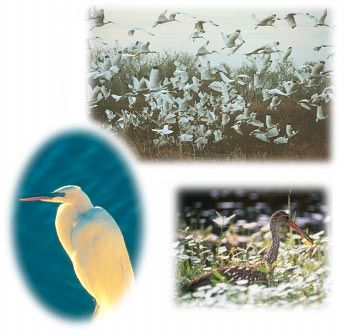
16. Water level in Lake Umatilla, Lake County, and the cumulative difference between rainfall and
     lake evaporation..........................................................................................................................................................   21
 17. Interactions between ground-water and lake water levels..........................................................................................                            22
 18. Cross section through a sinkhole lake showing ground-water seepage......................................................................                                     23
 19. Surficial-aquifer spring flow and Floridan-aquifer spring flow to a lake...................................................................                                  24
 20. Water-level fluctuations in a drainage lake (Lake Apopka) and a seepage lake (Lake Francis) ................................                                                 25
 21. Water level in Sand Hill Lake, Brooklyn Lake, and in a well near Brooklyn Lake ...................................................                                           26
 22. Water levels in Lake Apopka and Lake Apshawa illustrating the effect of seiche on water levels ...........................                                                   27
 23. Examples of lake water-level control devices ............................................................................................................                    28
 24. Examples of an oligotrophic, mesotrophic, and eutrophic lake..................................................................................                               29

Contents                                                                                 iv
GLOSSARY

Alkalinity: A measure of the capacity of the water to                 Hydrologic budget: An accounting of the inflow to, outflow
     neutralize acids.                                                      from, and storage in a drainage basin.
Aquifer: A geologic formation, group of formations,                   Hydrologic cycle: A term denoting the circulation of water
     or part of a formation that contains sufficient saturated,             from the ocean, through the atmosphere, to the land;
     permeable material to be able to yield significant                     and then, with many delays, back to the ocean by
     quantities of water to wells and springs.                              overland and subterranean routes, and in part by way
Artesian: A condition in which ground water in a well rises                 of the atmosphere; also includes the many paths by
     above the top of the water-bearing formation that is                   which water is returned to the atmosphere without
     tapped by the well.                                                    reaching the ocean.
Buffered: The resistance of water to a change in pH.                  Hydrology: The science of the water of the Earth.
Carbonates: Rock composed chiefly of carbonate minerals               Hydrostatic pressure: The pressure exerted by the water at
     (calcium, magnesium); examples are limestone and                       any given point in a body of water at rest.
     dolomite.                                                        Infiltration: The flow of water into the surface of the Earth
Condensation: The process by which water changes from                       through the pores of the soil at land surface. Distinct
     the vapor state into the liquid or solid state.                        from percolation (see definition).
Conductivity: See specific conductance.                               Interception: The process and the amount of rain stored
                                                                            on leaves and branches of vegetation that eventually
Dissolved oxygen: Atmospheric oxygen that is dissolved
                                                                            evaporates back to the atmosphere.
     and held in solution in water. Only a fixed amount of
                                                                      Limnology: The branch of hydrology pertaining to the study
     oxygen can be dissolved in water at a given tempera-
                                                                            of lakes.
     ture and atmospheric pressure.
                                                                      Overburden: The loose soils, sand, gravel, or other
Dissolved solids: The sum of all the dissolved constituents
                                                                            unconsolidated materials overlying a rock stratum.
     in a water sample. Major components of dissolved
                                                                      Nitrogen: An essential plant nutrient. High concentrations
     solids are the ions of the following: calcium,
                                                                            can lead to excessive plant growth and water-quality
     magnesium, sodium, postassium, bicarbonate, sulfate,
                                                                            problems.
     and chloride.
                                                                      Pan coefficients: Mathematical ratios that relate lake
Drainage basin: A part of the surface of the Earth that
                                                                            evaporation to measured pan evaporation.
     drains to a body of water by way of overland flow or
                                                                      Percolation: Flow of water through a porous substance,
     stream flow.
                                                                            usually in a vertical direction (downward). Rainfall, as
Drainage lake: A lake that has a surface-water outlet.                      it reaches the land surface, first infiltrates the surface,
Evaporation: The process by which water is changed from                     then percolates downward.
     the liquid state into the gaseous state through the              pH: A measure of how acidic or alkaline water is, based on
     transfer of heat energy.                                               the concentration of hydrogen ions in the water.
Evapotranspiration: The sum of water lost from a given                Phosphorus: An essential plant nutrient. High concentra-
     land area during any specified time by transpiration                   tions can lead to excessive plant growth and water-
     from vegetation and building of plant tissue; by                       quality problems.
     evaporation from water surfaces, moist soil, and snow;           Potential evapotranspiration: The maximum amount of
     and by interception (rainfall that never reaches the                   water that would be evaporated and transpired if there
     ground but evaporates from surfaces of plants and                      was no deficiency of water in the soil at any time for
     trees).                                                                the use of vegetation.
Flushing rate: The rate (volume per unit time) at which               Potentiometric surface: An imaginary surface that
     water leaves a lake, either through a surface-water                    represents the height to which water will rise in a
     outlet or through ground-water seepage.                                tightly cased well.
Geomorphology: The study of the configuration and                     Precipitation: The discharge of water, in liquid or solid
     evolution of land forms.                                               state, out of the atmosphere, generally upon a land or
Ground water: Water below the land surface in the zone of                   water surface. It is the common process by which
     saturation.                                                            atmospheric water becomes surface or subsurface
Hydraulic gradient: The difference in water levels at two                   water. Precipitation includes rain, hail, sleet, and snow.
     points divided by the distance between the two points.           Residence time: The time necessary for the total volume of
     Either horizontal or vertical hydraulic gradients can be               water in a lake to be completely replaced by incoming
     measured.                                                              water.

                                                                  v                                                          Glossary
Retention pond: A pond constructed for the purpose of                 Spring: Site at which ground water flows through a natural
     retaining stormwater runoff. Water in retention ponds                 opening in the ground onto the land surface or into a
     evaporates or infiltrates the bottom of the pond,                     body of surface water.
     eventually recharging the underlying ground water. If            Surface runoff: That part of precipitation that does not
     there is a surface outlet to another body of water, the               infiltrate the land surface, but travels along the land
     pond is called a detention pond.                                      surface.
Seepage: The process of water moving slowly through the               Surface water: Water that is present on the land surface,
     subsurface environment, or the actual water involved                  generally referring to lakes and streams.
     in the process of seepage.                                       Transpiration: The process by which plants take water from
Seepage lake: A lake that has no surface-water outflow; a                  the soil, use it in plant growth, and then transpire it to
     landlocked lake.                                                      the atmosphere in the form of water vapor. Evaporation
Seiche: The free oscillation of the bulk of water in a lake                and transpiration are often combined in one term,
     and the motion caused by it on the surface of the lake.               Evapotranspiration.
Sinkhole: A funnel-shaped depression in the land surface              Unsaturated zone: The zone between land surface and the
     that connects with underground passages or caverns.                   water table where the pores in the soil matrix are filled
Solution processes: The chemical processes by which rock                   with air and water.
     is dissolved by interactions with water.                         Water table: The upper surface of the zone of saturation in
Specific conductance: A measure of the property of water to                the ground. The water table commonly is at
     conduct a current of electricity. Specific conductance is             atmospheric pressure.
     commonly used as an indicator of the dissolved solids            Zone of saturation: The zone in which the soil or rock is
     content of water.                                                     saturated with water under hydrostatic pressure.

           Sources: Langbein, W.B., and Iseri, K.T., 1966; Fernald, E.A., and Patton, D.J., 1984; and Lane, Ed, ed., 1994

Glossary                                                         vi
Hydrology of Central Florida Lakes—A Primer
By Donna M. Schiffer

INTRODUCTION                              Polk (Hughes, 1974b). Lakes add to      primer was prepared by the
                                          the aesthetic and commercial value      U.S. Geological Survey (USGS) in
                                          of the area and are used by many        cooperation with the St. Johns River
               akes are among the
                                          residents and visitors for fishing,     Water Management District and the

L
               most valued natural
                                          boating, swimming, and other types      South Florida Water Management
               resources of central
                                          of outdoor recreation. Lakes also       District. The USGS has been
               Florida. The land-
                                          are used for other purposes such as     collecting hydrologic data in central
               scape of central
                                          irrigation, flood control, water        Florida since the 1920’s, obtaining
               Flo rida is r iddle d
                                          supply, and navigation. Residents       valuable information that has been
               with lak es—w he n
               viewed from the air, it    and visitors commonly ask ques-         used to better understand the
almost seems there is more water          tions such as “Why are there so         hydrology of the water resources of
than land. Florida has more natu-         many lakes here?”, “Why is my lake      central Florida, including lakes. In
rally formed lakes than other south-      drying up (or flooding)?”, or “Is my    addition to data collection, as of
                                          lake spring-fed?” These questions       1994, the USGS had published
eastern States, where many lakes
                                          indicate that the basic hydrology of    66 reports and maps on central
are created by building dams across
                                          lakes and the interaction of lakes      Florida lakes (Garcia and Hoy,
streams. The abundance of lakes on
                                          with ground water and surface           1995).
the Florida peninsula is a result of
the geology and geologic history of       water are not well understood by the         The main purpose of this primer
the State. An estimated 7,800 lakes       general population.                     is to describe the hydrology of lakes
in Florida are greater than 1 acre in         Because of the importance of        in central Florida, the interactions
                                          lakes to residents of central Florida   between lakes and ground- and
surface area. Of these, 35 percent
                                          and the many questions and              surface-waters, and to describe how
are located in just four counties
                                          misconceptions about lakes, this        these interactions affect lake water
(fig. 1): Lake, Orange, Osceola, and
                                                                                  levels. Included are descriptions of
                                                                                  the basic geology and geomor-
                                                                                  phology of central Florida, origins
                                                                                  of central Florida lakes, factors that
                                                                                  affect lake water levels, lake water
                                                                                  quality, and common methods of
                                                                                  improving water quality. The
                                                                                  geographic area discussed in this
                                                                                  primer is approximate (fig. 1) and
                                                                                  includes west and east-central
                                                                                  Florida, extending from the Gulf of
                                                                                  Mexico to the Atlantic Ocean coast-
                                                                                  lines, northward into Marion,
                                                                                  Putnam, and Flagler Counties, and
                                                                                  southward to Lake Okeechobee.
                                                                                  The information presented here was
                                                                                  obtained from the many publica-
                                                                                  tions available on lakes in central
                                                                                  Florida, as well as from publica-
Many lakes in central Florida are used for recreation. (Photograph provided by    tions on Florida geology, hydro-
St. Johns River Water Management District.)                                       logy, and primers on ground water,

                                                             1                                              Introduction
characteristics. Lakes typically
                                                                                     have emergent vegetation along the
                                                                                     shoreline with a large expanse of
                                                                                     open water in the center. Swamps or
                                                                                     wetlands, on the other hand, are
                                                                                     characterized by a water surface
                                                                                     interrupted by the emergence of
                                                                                     many varieties of plant life, from
                                                                                     saw grasses to cypress trees.
                                                                                         Lakes may be naturally formed
                                                                                     or manmade; however, the distinc-
                                                                                     tion between naturally formed and
                                                                                     manmade lakes is not always clear.
                                                                                     For example, retention ponds,
                                                                                     which are required for the treatment
                                                                                     of stormwater, can be constructed
                                                                                     so that they serve multiple purposes
                                                                                     of stormwater treatment and
                                                                                     aesthetic enhancement of property.
                                                                                     Larger retention ponds sometimes
                                                                                     are used by residents for boating
                                                                                     and fishing and are considered by
                                                                                     some to be lakes.
                                                                                         In addition to aesthetic value
Figure 1. Approximate geographic area covered by this report and distribution of
lakes (dark blue) in Florida. Outlined counties contain 35 percent of the lakes in   and recreational uses, lakes in
Florida.                                                                             central Florida are extremely
                                                                                     important as habitats for fish, alliga-
                                                                                     tors, turtles, and birds such as
surface water, and water quality.          in the land surface could be              hawks, eagles, ducks, and herons.
Many publications are available            considered a lake. Lakes differ from      Because Florida lakes are used and
that provide more detailed informa-        swamps or wetlands in the type            enjoyed by many, they need to be
tion on lake water quality, and this       and amount of vegetation, water           ap pre ciate d, un de rsto od, a nd
primer is not intended as an exten-        depth, and some water-quality             managed for the benefit of all.
sive treatise on that subject. The
reader is referred to the reference
section of this primer for sources of                                                                      Alligators are
more detailed information on lake                                                                          common in
water quality. Lakes discussed in                                                                          Florida lakes,
                                                                                                           although their
this report are identified in figure 2.                                                                    population
Technical terms used in the report                                                                         varies from
                                                                                                           one lake to
are shown in bold italics and are                                                                          the next.
defined in the glossary.                                                                                   (Photograph
    The classification of some water                                                                       provided by
                                                                                                           South Florida
bodies as lakes is highly subjective.                                                                      Water
What one individual considers a                                                                            Management
“lake” another might consider a                                                                            District.)
“pond.” Generally, any water-filled
depression or group of depressions

Hydrology of Central Florida Lakes—A Primer                   2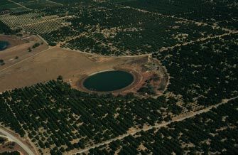
Figure 2. Lakes and weather stations in this report.

                                                       3   Introduction
CLASSIFICATION                           water quality). Residents of and
                                          OF LAKES                                 visitors to central Florida have
                                                                                   added their own classification
                                              Lakes are classified according       system by describing a particular
                                          to different criteria including loca-    lake as a good fishing or water-
                                          tion, origin, drainage characteris-      skiing lake.
                                          tics, trophic state (a measure of the
                                                                                       Lakes in Florida and elsewhere
                                          amount of nutrient enrichment of
                                                                                   commonly are classified by
                                          the water), and water chemistry.
                                                                                   drainage characteristics; it is these
                                          Lakes commonly are classified by
                                          geologists according to the physio-      characteristics that differentiate
                                          graphic region in which the lakes        Florida lakes from lakes in other
                                          are located. Many lakes in Florida       parts of the country. This general
                                          were formed by sinkhole activity         classification divides lakes into one
                                          and thus are called sinkhole lakes.      of two major types—seepage and
                                          Environmental scientists may             drainage lakes. Although there are
                                          classify lakes according to the state    many other hydrologic characteris-
                                          of water quality (this classification    tics associated with each type
                                          system is described in the section on    (fig. 3), perhaps the most easily
    Hydrologic characteristics of
central Florida lakes vary widely.
The surface areas of lakes can range
from several hundred square miles,
such as Lake Okeechobee, to less
than an acre. Water levels in some
lakes may vary by 10 feet or more,
whereas in other lakes, the water
level may vary by only 1 or 2 feet.
The quality of water among lakes in
central Florida also is variable, from
pristine lakes such as Lake Butler in
west Orange County to the pea-
green-colored waters of Lake
Apopka, a short distance to the
north in Orange and Lake Counties
(although the clarity of water is not
necessarily an indication of the
quality of the water). Some lakes
have natural surface-water inlets
and outlets. Other lakes are land-
locked, receiving water only from
rainfall and losing water only from
evaporation and seepage into the
surrounding soils. This great variety
in hydrologic characteristics is one
of the reasons why water levels vary
among lakes and why lakes respond
differently to rainfall.                           Figure 3. Hydrologic characteristics of seepage and drainage lakes.

Hydrology of Central Florida Lakes—A Primer                4
recognized property used to
distinguish between seepage and
drainage lakes is the absence or
presence (respectively) of surface-
water outflow. Lakes that have no
surface-water outflow lose water
primarily through the ground-water
system or through evapotranspira-
tion and are called seepage lakes.
Lakes that lose water primarily
through a surface-water outlet are
called drainage lakes (Wetzel,
1975). Most Florida lakes are
seepage lakes—nearly 70 percent of
the lakes in Florida have no surface-
water streams flowing into or out of
them (Palmer, 1984). The drainage
basin of a seepage lake commonly
is referred to as a closed basin
because of the lack of surface-water
outflow from the basin; however,
there is outflow from the basin
through ground-water seepage. The
drainage basins of drainage lakes
are commonly referred to as open-
drainage basins. Florida has numerous wading birds that make use of the many
lakes here. (Photographs provided by South Florida Water Management District.)
The dominance of ground-water
flow over surface-water flow in
much of Florida makes the
hydrology of lakes here different
from that of lakes in other parts of contributing drainage basin. Ulti- THE HYDROLOGIC CYCLE
the country. The well-drained mately, however, the most signifi-
porous soils and rocks that are cant difference between seepage Wa t e r in th e e n v i r o n m e n t
characteristic of the karst landscape and drainage lakes is not the source moves from the atmosphere, to the
of Florida are what make this of the water, but the controlling land surface, to the ground-water
difference. One difference between factors affecting lake water volume system, and back to the atmosphere
Florida lake hydrology and that of (ground-water or surface-water in a cycle called the hydrologic
o th e r p ar t s o f th e c o u n tr y is outflows). cycle (fig. 4). In this section, the
expressed in the classical definition components of the hydrologic cycle
of a drainage basin. A drainage are described to provide the neces-
b as i n o r w a te rs h e d (t h e a re a sary background for an under-
contributing water) of a lake Most Florida lakes are standing of lake hydrology.
commonly refers to the land surface seepage lakes—nearly The primary components of the
area draining to a water body as 70 percent of the lakes hydrologic cycle in central Florida
defined by topography. However, in Florida have no are rainfall, runoff, infiltration
because most of the inflow to surface-water streams (including recharge), evaporation,
seepage lakes in Florida is from flowing into or transpiration, and condensation.
ground water, the ground-water out of them. When rain falls, some of the water
basin must be considered part of the infiltrates the ground and recharges
5 The Hydrologic CycleFigure 4. Hydrologic cycle. (Modified from Fernald and Patton, 1984.)
aquifers, some of it is intercepted by Some of the components of the water from rain falling on the
plants, and some of it flows over the hydrologic cycle can be quantified surface of the lake, from surface
land surface (surface runoff or by using measuring devices to runoff within the drainage basin,
overland flow). Beneath the land collect data, and a “water budget” of from streamflow, and from ground
surface, water moves through the a lake (an accounting of the total water entering the lake (labeled as
aquifers toward areas of discharge volume of water entering and lateral seepage in fig. 5). Lakes lose
such as the ocean or streams. Water exiting the lake) can be determined water to evaporation, seepage
from these data. Much of the
returns to the atmosphere through through the bottom, and streamflow
research on Florida lakes has
the processes of evaporation and (in lakes with surface-water
focused on water budgets in an
plant transpiration (collectively connections). Rainfall and stream-
effort to better understand the
labeled “evapotranspiration” in complex hydrologic system of a flow are relatively easy to measure,
fig. 4). Once in the atmosphere as lake and to determine how each but recharge, evaporation, and
water vapor, the hydrologic cycle is component of the hydrologic cycle seepage are much more difficult to
completed when this vapor affects lake water levels and water determine accurately. The compo-
condenses and forms rain droplets quality. A schematic of the compo- nents of the hydrologic cycle are
that subsequently fall on the land nents of a lake water budget is discussed in more detail in the
surface again. shown in figure 5. Lakes receive following sections.
Hydrology of Central Florida Lakes—A Primer 6Rainfall significantly more rain in some monthly rainfall during a 30-year
areas than in others, whereas period (1961–90) at two rainfall
The climate of central Florida is rainfall during the dry season stations in DeLand and Orlando
subtropical, with warm, wet affects larger geographic areas. (fig. 6, locations shown in fig. 2).
summers and mild, fairly dry Some of the differences in lake Both stations are inland and are
winters. The wet season, which water levels, particularly during only about 30 miles apart, so one
begins in June and ends in summer months, can be the result of might expe ct similar rainfall
September, accounts for more than local differences in rainfall amount amounts. Total rainfall at these two
half (56 percent) of the rainfall stations is similar for some months,
or intensity.
during the year (Schiner, 1993). but the rainfall at DeLand tends to
Total monthly or annual rain-
Rainfall during the wet season be greater than the rainfall at
generally is associated with local fall also is variable from location to
Orlando, particularly during the
showers and thunderstorms. location. For example, the average months of August, September, and
Rainfall during the dry season annual rainfall, based on 30 years October, illustrating regional vari-
(October through May) generally is of record (1961–90), ranges from ability. Mean annual rainfall at
associated with frontal systems 4 3 . 9 2 i n c h e s i n Ta m p a t o DeLand (56.05 inches) is nearly
moving from northern latitudes 54.09 inches in St. Leo (see fig. 2 8 inches greater than mean annual
southward. Rainfall during the wet for station locations). The rainfall at Orlando (48.11 inches)
season can be highly localized with variability from one location to for the period 1961–90, indicating
heavy thunderstorms producing another is indicated by the average that long-term rainfall patterns can
differ significantly even at locations
that are relatively close and in
similar settings.
Some of the differences
in lake water levels,
particularly during
summer months, can
be the result of local
differences in rainfall
amount or intensity.
The annual rainfall for
Jacksonville, the site with the
longest rainfall record in Florida, is
shown in figure 7. Rainfall record-
keeping started in 1851, but there is
a break in the otherwise continuous
record for 1861–66. Total annual
rainfall is shown in the upper graph
of figure 7. In the middle graph, the
difference between the rainfall for
each year and the long-term average
is shown (based on the period
1866–1993). Just as daily rainfall
varies from one day to the next, total
annual rainfall varies from one year
Figure 5. Major components of the hydrologic budget for a central Florida lake
in a ground-water recharge area. to the next. The difference between
7 The Hydrologic CycleOne way that lake evaporation
is estimated is from evaporation
measured using a standard 4-foot
diameter, shallow metal pan. Pan-
evaporation rates are greater than
lake-evaporation rates and must be
corrected using pan coefficients,
which are mathematical ratios
that relate lake evaporation to pan
evaporation.
Annual lake evaporation for
the central Florida area was esti-
mated to be about 51 inches, based
on 28 years (1960–88) of pan-
evaporation data recorded at the
Lisbon and Gainesville weather
stations (locations shown in fig. 2)
Figure 6. Mean monthly rainfall at DeLand and Orlando for the period 1961–90 and pan coefficients determined in
and lake evaporation based on pan evaporation (1960–88).
studies at Lake Hefner, near Lake
Okeechobee, by Kohler (1954).
annual rainfall and the long-term Evaporation and Other estimates of annual lake
average annual rainfall is called the Transpiration evaporation reported by researchers
“departure” from average for that in central Florida have ranged from
year. These annual departures from Most of the rain that falls is 47 inches (Phelps and German,
the average can have a cumulative returned to the atmosphere by evap- 1 9 9 6 ) t o 5 8 in ch es ( L e e a n d
effect on lake water levels. For oration and by transpiration from Swancar, 1994). The annual lake-
example, a series of years with less plants. Commonly, evaporation and evaporation rate of 51 inches is
than average rainfall may result in transpiration are considered greater than the average yearly
lake water levels that are lower than together and called evapotranspira- rainfall at Orlando (48.11 inches,
tion. Water that is in the soil near the based on rainfall from 1961–90);
the long-term average level for that
land surface can return to the atmo- however, lake evaporation repre-
lake. The bottom graph of figure 7
sphere through evaporation. The sents the maximum possible rate of
illustrates how the difference
highest evaporation rate is from evaporation. The actual evapora-
between annual rainfall and the
open water surfaces such as lakes.
average rainfall, when accumulated tion rate over a large region is
Evaporation from a lake surface is
from one year to the next, can considerably lower than the lake-
referred to specifically as lake evap-
produce trends of excess or deficit evaporation rate because the water
oration. The evaporation rate is
rainfall. Excess rainfall early in the is evaporating from land surfaces as
affected by several variables such as
period, from 1866 through about the amount of moisture in the air well as water surfaces. Although the
1889, produced enough of a cumu- (humidity), the amount of sunlight, actual evaporation in the drainage
lative surplus of rainfall (bars wind, and temperature. Thus, evap- basin of a lake can be estimated for
shown above the zero line) that it oration rates are variable; in central a water budget, the computation can
was 25 years before lower-than- Florida, evaporation rates have be complex because it requires
average annual rainfall produced a been estimated to be as low as information about land use, depth to
deficit (bars shown below the zero 25 inches per year and as high as the water table, and other hydro-
line, beginning in 1917). 50 inches per year (Tibbals, 1990). logic variables.
Hydrology of Central Florida Lakes—A Primer 8Figure 7. Annual rainfall at Jacksonville, the station with the longest record in Florida.
9 The Hydrologic CycleSurface Runoff
Rainfall that has not infiltrated
the soil and has not been returned
to the atmosphere by evapotranspi-
ration flows over the land surface
and eventually reaches a lake or
stream. Surface runoff refers to
water flowing over the land surface
and to water in streams and rivers.
Surface runoff is a significant
com ponen t of the hy drologic
budget of drainage lakes. In seepage
lakes, however, ground-water
inflows and outflows dominate the
hydrologic budget, and the compo-
nent represented by surface runoff
is relatively small.
Infiltration and Ground-
Water Recharge and Figure 8. Ground-water movement in recharge and discharge areas.
Discharge
Part of the rainfall that reaches Florida are located in discharge have been deposited, rather than
the land surface infiltrates the soil, areas. Lakes in central Florida are marine carbonates. Subsequent
where it gradually percolates pr ese nt in b o th re ch arge a nd fluctuations of sea level during
downward until it reaches the surfi- discharge areas. episodes of glaciation have eroded,
cial aquifer system (fig. 8). This reworked, and transported the
water replenishes the surficial unconsolidated sand, silt, and clay
aquifer system, which in turn GEOLOGY OF sediments.
r e p l e n i s h e s o r r e c h a rg e s t h e CENTRAL FLORIDA The Florida peninsula is a
Floridan aquifer system. This product of sedimentary processes,
downward movement can occur The Florida peninsula is and Florida’s geology reflects these
only where the water table of the composed of carbonate rock (lime- processes. The geology of central
surficial aquifer system is higher (at stone and dolomite) that was Florida is shown in figure 9, which
a greater altitude) than the potentio- deposited over a period of about also shows the hydrogeologic units,
metric surface of the Floridan 1 0 0 m i ll i o n y ea r s . F o r ab o u t
or aquifers and confining units,
aquifer system. The areas in the 75 million years, during the
corresponding to the geology.
State where ground water is replen- Cretaceous Period (138 to
ished are referred to as recharge Underlying the deepest rocks
63 million years ago), Florida was
areas. In areas where the potentio- shown in the diagram in figure 9 are
covered by relatively deep oceans.
metric surface of the Floridan Later, from about 63 to 38 million several thousand feet of igneous,
aquifer system is at a higher altitude years ago, the Florida peninsula was metamorphic, and sedimentary
than the water table of the surficial a shallow carbonate reef. Sea level rocks that form the foundation of
aquifer that overlies it, water moves then receded and rose several times, the peninsula. Above these rocks
upward toward the land surface. eroding and depositing carbonates, are the Cedar Key, Oldsmar, and
These areas are referred to as until about 5 million years ago. Avon Park Formations, and the
discharge areas or areas of artesian Since that time, land-derived sedi- Ocala and Suwanee Limestones
flow (fig. 8). The many springs in ments such as sand, silt, and clay (fig. 9). These formations consist of
Hydrology of Central Florida Lakes—A Primer 10limestone, dolomite, anhydrite, and land surface are unconsolidated Later in geologic time, the sedi-
gypsum and were deposited when sediments generally consisting of ments of the Hawthorn Group were
most of the Florida peninsula was quartz sand, clay, and some organic deposited on top of this irregular,
below sea level. The total thickness material. eroded limestone surface. There-
of these formations ranges from The thickness of the Hawthorn fore, the thickness of the Hawthorn
5,500 to 12,000 feet (Tibbals, Group, which varies greatly in Group varies depending on the
1990). The overlying Hawthorn central Florida, is a key element in original altitude of the surface
Group, deposited about 25 million the lake formation process where it was deposited. In those
(described in a later section). When areas where the sediments of the
years ago, represents a transition
rocks of the marine-formed Ocala Hawthorn Group are thin, more
between marine-derived and land-
Limestone and Suwanee Limestone surface water can penetrate to the
derived sediments. The lower layers
Formations were exposed at land underlying rock of the Ocala and
of the Hawthorn Group generally
surface, the rock was eroded by Suwanee Limestone Formations
are marine-derived and contain and continue the erosional process.
wind, rain, flowing water, and
limestone, whereas the upper layers thermal changes (expansion and These are areas prone to sinkhole
of clay, fine sand, and silt are land- contraction due to seasonal temper- development. In those areas where
derived. These upper layers of the ature change). Because the the Hawthorn Group is thicker, the
Hawthorn Group generally restrict erosional process is not necessarily underlying rock is more shielded
ground-water movement. Over- uniform from one location to from the effects of continued
lying the Hawthorn Group and another, the eroded surface of the erosion, and sinkholes are less
continuing upward to the present limestone can be very irregular. common.
Figure 9. Generalized summary of geologic and geohydrologic units in central Florida. (Modified from Miller, 1986; Tibbals,
1990; Bradner, 1994; Phelps, 1987; Lopez and Fretwell, 1992.)
11 Geology of Central FloridaGROUND WATER term “system” is used to indicate refers to water below the water
the presence of more than one table. The water table is in contact
In this section of the primer, water-bearing layer or aquifer; for with the atmosphere through the
the ground-water system in central regional analysis these multiple unsaturated zone; therefore, the
Florida is described to provide the layers of aquifers are collectively water table is at atmospheric pres-
background for understanding lake considered as a single geohydro- sure. The depth to the water table
formation, water levels in lakes, and logic unit (fig. 9). can range from 50 feet or more
th e qu ali ty o f w a ter in lak es In central Florida, the aquifer below land surface to above land
discussed in subsequent sections. nearest the land surface is the surfi- surface in wetlands and lakes.
Florida’s ground water is contained cial aquifer. The water table refers (Because the water surface of a lake
in aquifers. An aquifer is a layer or to a surface below which all the is the water table, and the land
a combination of several layers of openings or spaces in the soil or surface is actually the submerged
permeable soils or rocks that yield rock are filled with water (satu- lake bottom, the water table is
usable quantities of water. The rated). Pores in the soil between the above land surface in lakes.)
major aquifers in central Florida are land surface and the water table are Beneath the surficial aquifer
identified in figure 9 under the filled with both water and air; this system lies the intermediate
column labeled “Geohydrologic uppermost layer above the water confining unit, which is composed
Unit” and in the generalized cross table is referred to as the unsatur- of layers of clays, fine silts and, in
section shown in figure 10. The ated zone. The term ground water some areas, limestone beds. The
Figure 10. Geology and major aquifers in central Florida.
Hydrology of Central Florida Lakes—A Primer 12materials that make up the interme- water (thus the name “intermediate Central Highlands region range
diate confining unit in most of confining unit”). This condition is from about 40 to 325 feet above sea
central Florida generally are not commonly called artesian because level. The Coastal Lowlands border
very permeable, thus, this unit water levels in wells drilled into the the entire coast of Florida, and land
restricts the movement of water aquifer rise above the top of the elevations generally are less than
from above and below. In some aquifer and, in some places, above 100 feet (Cooke, 1945).
areas, the lower part of the interme- land surface (fig. 10). The level to The central Florida area is char-
diate confining unit may consist of which the water rises is referred to acterized by discontinuous high-
highly fractured limestone and as a potentiometric surface. Wells lands separated by broad valleys.
dolomite, which can produce usable that tap the Floridan aquifer system One of the effects of the rise and fall
quantities of water; however, in in ground-water discharge areas are of sea level was the formation of
m o s t a r e a s , t h e i n t e r m e d ia t e commonly referred to as artesian relict shoreline features such as
confining unit is not used for water wells, particularly if the potentio- beach ridges, which parallel the
supply. metric level in the well is greater present-day Atlantic coastline
The Floridan aquifer system than the land surface; where this (fig. 11). These beach ridges have
underlies the intermediate con- occurs, water will flow out of the had an effect on the shape, location,
fining unit and is the primary source well as shown in figure 10. In areas and orientation of lakes in central
of nearly all the drinking water in where the limestone of the Floridan Florida. Swales between the beach
central Florida. The rock that aquifer system is at or near land ridges (shown as plains in fig. 11)
contains the Floridan aquifer surface and there are no confining are areas where surface water
system generally consists of highly sediments, water in the aquifer is collected when sea level dropped,
permeable limestone and dolomite. not under pressure; in these areas,
causing a decline in the water table
The top of the aquifer is at or near the aquifer is not artesian.
and increasing the downward
land surface in west-central Florida movement of water. This increase in
(including Marion and Sumter vertical water movement in turn
Counties) and can be as deep as GEOMORPHOLOGY AND accelerated the lake formation
several hundred feet below land THE ORIGIN OF CENTRAL processes, which partly explains the
surface in other areas of central FLORIDA LAKES abundance of lakes in central
Florida. The Floridan aquifer
The geomorphology of the F l o r i d a . Wi t h i n t h e C e n t r a l
system is further divided into
Florida peninsula provides clues to Highlands of the Florida peninsula
the Upper Floridan and Lower
geologic history and the origin of is the most extensive area of closely
Floridan aquifers (fig. 9). The
lakes. Physical features of the land spaced lakes in North America. The
Upper Floridan aquifer is the
surface of central Florida have been nearest counterparts to the lake
primary source of drinking water,
used to define p hysiog raphic district of Florida are in Canada and
al tho u gh t he L o we r F lor id an
regions, some of which are associ- in the northern United States from
aquifer is used in some areas.
ated with the abundance of lakes. Minnesota to Maine.
The physical features of Florida are Lakes in Florida were formed
The Floridan aquifer by several processes. The lime-
quite varied, although compared
system is the primary to other parts of the country the stones and dolomites that underlie
source of nearly all State is rather flat and featureless. central Florida are “soft” rocks that
the drinking water in Physical features of central Florida are easily dissolved by rainwater
central Florida. range from highlands, ridges, and entering the subsurface environ-
upland plains to lowlands and ment from the land surface and by
Water in the Floridan aquifer coastal marshes. Cooke (1945) the ground water moving through
system is under pressure in much of described two major physiographic the rock matrix. The chemical
central Florida because the over- regions in central Florida: the processes by which rock is
lying clays and silts of the Central Highlands and the Coastal dissolved by interactions with water
Hawthorn Group act to confine the Lowlands. Land elevations in the a r e c o m m o n l y r e fe r r e d to a s
13 Geomorphology and the Origin of Central Florida Lakesareas wh ere the interm ediate
confining unit between the uncon-
solidated materials of the surficial
aquifer system and the underlying
limestone of the Floridan aquifer
system is thin, breached, or absent.
With few exceptions, sinkholes
form in areas of recharge to the
Floridan aquifer system. In these
areas, ground water easily moves
downward from the land surface to
the limestone. Carbon dioxide from
the atmosphere and soil zone is
carried with the ground water and
forms carbonic acid, a weak acid
th at d iss ol ve s th e lime sto n e,
eventually forming cavities and
caverns. In contrast, in areas where
the intermediate confining unit is
intact and water in the aquifer is
confined, less water from the
surface reaches the limestone and
sinkholes are not as common.
By far, the most
common origin of Florida’s
lakes is by
solution processes.
The three general types of
sinkholes—subsidence, solution,
and collapse—in central Florida
generally correspond to the thick-
ness of the sediments overlying the
limestone of the Floridan aquifer
Figure 11. Major physiographic regions of central Florida. (Modified from Cooke,
1945.) system. The sediments and water
contained in the unsaturated zone,
surficial aquifer system, and inter-
solution processes. The past and of sinkholes (depressions in the mediate confining unit collectively
are termed overburden in the
continuing solution of the limestone land surface), springs, circular-
following description of sinkhole
beneath the land surface by ground shaped lakes, and large cavities in
formation. Collapse sinkholes are
water results in a landform called the limestone and dolomite rocks.
most common in areas where the
karst. Common characteristics of a By far, the most common origin overburden is thick, but the inter-
karst landform include a lack of of Florida’s lakes is by solution mediate confining unit is breached
surface drainage (nearly all the processes. Solution processes are or absent. Subsidence sinkholes
rainfall infiltrates into the ground the underlying cause of sinkholes, form where the overburden is thin
and few drainage channels or which over time become lakes. and only a veneer of sediments is
streams develop) and the presence Sinkholes are most common in present overlying the limestone.
Hydrology of Central Florida Lakes—A Primer 14Solution sinkholes form where the
overburden is absent and the lime-
stone is exposed at land surface.
Collapse sinkholes are the most
dramatic of the three sinkhole
types; they form with little warning
and leave behind a deep, steeply
sided hole. Collapse occurs because
of the weakening of the rock of the
aquifer by erosional processes and
is often triggered by changes in
water levels in the surficial and
Floridan aquifer systems. The
progression of a collapse sinkhole is
shown in figure 12. A small cavity
in the limestone of the Floridan
aquifer system gradually grows
larger as the rock is dissolved by the
ground water flowing through it.
The weight of the overburden above
the cavity is supported by the roof
of the cavity and is partly supported
by pressure from the water in the
aquifer. As the cavity grows larger,
the rock that forms the roof of the
cavity becomes progressively
thinner. As water levels decline
during dry periods or because of
pumping, water pressure in the
limestone cavity decreases and the
weight of the overburden over-
comes the structural integrity of the
cavity roof. At this point, the roof
and overburden collapse into the
c a v i t y, f o r m i n g t h e s u r f ic i a l
“pothole” that is associated with
sinkholes and karst terrain. The
Winter Park sinkhole that formed in
M a y 1 98 1 (s ee ph o to , p . 1 7)
probably is the best known collapse
sinkhole in central Florida.
Although collapse sinkholes
generally form during dry periods,
they also can form as a result of
heavy rainfall during an extended
Figure 12. Formation of a collapse sinkhole.
period of time. The rise in the water
table of the surficial aquifer system
as a result of the increased rainfall
causes an increase in the weight of on the roof of a limestone cavity partially supporting the cavity roof
the overburden. A collapse occurs increases more rapidly than the and exceeds the structural strength
when the weight of the overburden water pressure in the cavity that is of the roof.
15 Geomorphology and the Origin of Central Florida LakesThe progression of a subsidence unconsolidated sediments above the depression at the land surface. As
sinkhole is shown in figure 13. limestone are carried downward the depression enlarges with time,
Rainwater percolates through with the percolating water and water begins to collect in the
overlying sediments and reaches occupy the spaces formed by the depression. Sand and clay are
the limestone, dissolving the rock dissolving limestone. With time, the carried to the newly formed
and gradually weakening its movement of sediments into the s i n k h o l e i n r u n o ff f r o m t h e
structural integrity. As the lime- openings in the limestone causes su rro un di ng la nd , ev en tua lly
settling, lining the bottom of the
stone continues to dissolve, the the formation of a bowl-shaped
depression, and restricting the flow
of water through the bottom. As
water continues to accumulate in
the depression, a lake is formed. An
example of a lake formed in this
way is Lake Tsala Apopka, in Citrus
County (see photo, p. 17). In this
area of central Florida, the lime-
stone is covered with a veneer of
unconsolidated sediments or is
exposed at the land surface. Lake
Tsala Apopka is actually a series of
lakes and marshes; the aerial view
shows the many depressions that
together form the lake.
With the passing of time, the
difference in appearance of lakes
formed by these different types of
sinkholes is less distinct. For
example, the photograph of the
Winter Park sinkhole was taken in
1994, 13 years after the sinkhole
formed. In the photo, the steep sides
of the sinkhole are no longer visible
because the water level has risen in
the sinkhole and the “sink” looks
very much like nearby lakes that
may have been formed by other
processes. Thus the specific type of
sinkhole that caused the lake to
form is not readily apparent.
Not all lakes in central Florida
were formed by solution processes.
Some central Florida lakes origi-
nally were natural depressions in
the ancient sea floor. These depres-
sions formed as a result of scouring
and redepositing of material by
wave action and water currents.
Freshwater eventually filled these
Figure 13. Formation of a subsidence sinkhole. depressions when sea level fell.
Hydrology of Central Florida Lakes—A Primer 16Lake Tsala-Apopka in west-central
Florida is an example of a lake
formed by solution processes. The
limestone in the area near this lake
is commonly seen at land surface.
(Photograph by L.A. Bradner,
U.S. Geological Survey.)
The top photograph shows the
Winter Park sinkhole shortly
after it formed in May 1981.
(Photograph by A.S. Navoy.)
In the bottom photograph, the
sinkhole is shown 13 years later,
in October 1994. (Photograph by
L.A B r adne r, U . S. Geo logi cal
Survey.)
17 Geomorphology and the Origin of Central FloridaFigure 14. Present-day lakes formed
when sea level fell and freshwater filled
depressions in the sea floor (Upper
St. Johns River chain of lakes).
Lakes formed in ancient
sea floor depressions or by
riverine processes differ in
shape, grouping, and
orientation of inlets and
outlets from lakes formed
by solution processes.
direction of the river flow, so that
the lakes appear to be threaded
together by the river (fig. 14). The
inlet and outlet of each lake line up
with the river and are oriented along
the long axis of the lake. Solution-
formed or sinkhole lakes tend to
appear in groups or clusters, rather
than in linear chains as in the Upper
St. Johns River lake chain. An
example of solution-formed lakes
are the lakes of the Ocklawaha
chain: Apopka, Harris, Griffin,
Dora, Eustis, and Yale (fig. 15). The
inlets and outlets of these lakes tend
to be randomly oriented with
respect to their long axes. Regard-
Examples of lakes that were formed processes to enlarge or change the less of the orientation of inlets and
in this way are the lakes that form a shape of lakes. Fo r ex ample, outlets of central Florida lakes, a
chain along the Upper St. Johns although Lakes Harney, Monroe, group of connected lakes are
River, including Lakes Helen and George (fig. 2) all originated commonly referred to as a chain of
Blazes, Washington, Winder, and from depressions in the ancient sea lakes.
Poinsett in Brevard County floor, riverine processes have Manmade lakes in Florida often
(fig. 14). These lakes, through continued to enlarge these lakes. are created for practical as well as
which the Upper St. Johns River Lakes formed in ancient sea aesthetic reasons. Sometimes these
flows, are remnants of an ancient floor depressions or by riverine lakes are referred to as “real-estate
estuary (White, 1970, p. 103). processes differ in shape, grouping, lakes,” and are used in housing
Probably the least common and orientation of inlets and outlets developments for stormwater treat-
origin of lakes in Florida is by from lakes formed by solution ment and for enhancement of the
fluvial, or riverine, processes. More processes. For example, the lakes natural landscape. Lakes of this
c o m m o n l y, f l u v i a l p ro c e s s e s that form the Upper St. Johns River type usually are not named, even
combine with other lake-formation chain of lakes are elongated in the though some are quite large. One
Hydrology of Central Florida Lakes—A Primer 18PHYSICAL
CHARACTERISTICS
OF LAKES
Some of the physical character-
istics of lakes include shape (length,
width), depth, surface area, and
total volume. As described in the
last section, the shape of a lake,
which may be circular, elliptical, or
irregular, is the result of the process
by which it was formed and the
environment in which it has existed
since it was formed. Because the
environment of a lake is dynamic,
physical characteristics may change
Although the unnamed lake in this aerial photograph taken in an area near with time, either as a result of
Sebring, Florida, has a nearly perfect circular shape indicating its sinkhole origin,
most solution-formed lakes do not have this perfect a shape! (Photograph by
natural environmental processes or
E.P. Simonds, U.S. Geological Survey.) because of human activity.
type of manmade lake is formed by
building a dam across a river.
Examples of this type of lake are
Lake Rousseau in west-central
Florida (located along the county
lines of Levy, Marion, and Citrus
Counties), which was created when
the Inglis Dam was built in 1969,
and Lake Ocklawaha in Putnam
County, which was created when
the Rodman Dam was built in 1968
(fig. 2). Both of these impound-
ments were created as part of the
Cross-Florida Barge Canal, which
was partially constructed in the
1960’s to connect the Atlantic
Ocean and the Gulf of Mexico for
shipping purposes but was halted
after concerns about environmental
impacts arose.
Figure 15. Lakes formed by solution
processes (Ocklawaha River chain of
lakes).
19 Physical Characteristics of LakesYou can also read