Baptiste and Island Lakes - Watershed Management Plan - Athabasca Watershed Council
←
→
Page content transcription
If your browser does not render page correctly, please read the page content below
Baptiste and Island Lakes
 Watershed Management Plan

                Baptiste and Island Lakes Stewardship Society
                                                  May, 2019
Baptiste and Island Lakes Stewardship Society

The Baptiste and Island Lakes Stewardship Society is a registered, non-profit society with the goal to
devise methods to preserve and protect the health of Baptiste and Island Lakes, while meeting the needs
of all stakeholders within both watersheds. The society works collaboratively with seven municipalities,
(Athabasca County and the Summer Villages of Sunset Beach, South Baptiste, West Baptiste, Whispering
Hills, Island Lake and Island Lake South), as well as numerous volunteers, partner organizations and
stakeholders.

For more information or to become a member, contact:
Baptiste and Island Lakes Stewardship Society
Email: Baptiste.Island.Lakes@gmail.com
http://www.bails.ca/

Acknowledgements

On behalf of the BAILS Board of Directors, we would like to thank a number of agencies and individuals
for supporting this initiative. First, we would like to acknowledge Alberta Community Partnership for a
$25,000 Inter-municipal Collaboration Grant to undertake this work. We also greatly appreciate the time
and dedication of members of the Steering and Technical Committees (see a list in Appendix 1) and their
supporting organizations. We note that, over the last several decades, there have been a number of
studies and monitoring initiatives carried out on both Baptiste and Island lakes by academia,
government and non-government agencies. Our work builds on those that came before us. More
recently, we are grateful to the North Saskatchewan Watershed Alliance (Breda Muldoon, Dave Trew
and Petra Rowell) for their guidance, technical and secretariat support. Finally, we thank all the
individuals who attended outreach events, reviewed drafts, conducted additional research or analysis,
collected samples, cooked hotdogs or otherwise lent a hand. As the saying goes, it takes a village!

Photos for this report were contributed by Wendy Appleby, Kendra Gilbert, Dennis Irving, Petra Rowell
and Dave Trew.

                                                   2
Executive Summary
Baptiste and Island Lakes are two moderate-sized lakes located 16 km west of Athabasca, in central
Alberta. Prized for fishing, boating and other outdoor pursuits, both lakes enjoy an active recreational
community made up of permanent and seasonal residents, and casual day-users.

Although naturally rich in nutrients that can lead to mid-to late summer algal blooms (including blue-
green algae or cyanobacteria), the health of both lakes is affected by the activities that surround them.
Recreational activities on the lake can disturb fish and other wildlife. Lakeshore development can
degrade shorelines (riparian areas) and affect water quality. Land use activities in the uplands, like
agriculture and forestry, can affect runoff, bringing sediment and nutrients into the lakes via tributary
streams. Taken together, the cumulative impacts of these activities, combined with climate variability or
change, can impair recreational use, as well as lead to irreversible declines in water quality and lake
health.

To manage these pressures, the Baptiste and Island Lakes Stewardship Society (BAILS), a group of
Summer Village and County councillors and interested volunteers, formed in 2014 with the intent to
undertake lake research and stewardship actions. Through their work, the need for a lake watershed
management plan was identified, hence this document.

The Baptiste and Island Lakes Watershed Management Plan is the result of several years of work to fill
data gaps, engage communities and stakeholders around both lakes, and identify actions that BAILS and
its partners can undertake to protect lake health. The audience for this plan includes provincial and
municipal decision-makers; lake, Indigenous and other communities; as well as landowners, lake users,
industry and others who can use the plan to inform decisions and encourage stewardship actions that
support the health of the Baptiste and Island Lakes watersheds.

While the plan identifies a long-term vision and goals, an accompanying action plan focusses in on what
can be done in the next five years, at which point the plan should be re-visited to ensure the vision and
goals are still relevant and achievable. The plan focuses on eight key topics, providing a review of what is
known about each topic, what the issues are, and what can be done about these issues, as summarized
briefly below:

    •   A Watershed Approach: Lake management is fragmented among several jurisdictions. However,
        all those with a mandate for some aspect of lake management can be brought together using a
        watershed approach. BAILS has initiated this process by first identifying all of the stakeholders in
        the Baptiste and Island lake watersheds; and second by engaging these stakeholders in
        discussions about lake health. Future work in this area should focus on continuing to engage
        decision-makers, stakeholders and others interested parties in acknowledgement and
        implementation of the Watershed Management Plan.

                                                     3
•   Stewardship: To be successful, lake watershed management must include individual lake users
    as stewards of these resources. However, coordinating stewardship activities takes time and
    money. BAILS has been innovative in finding both financial and in-kind support in the past and
    will need to continue to do so in order to build capacity for stewardship initiatives in the future.

•   Knowledge: Understanding the current state of health of Baptiste and Island lakes is key to
    managing these resources. Long term data collection and assessing trends is also important.
    BAILS has been active in finding answers about various aspects of lake health. This work should
    continue such that data gaps are filled, information is communicated to all who live, work or
    play in the watershed, and this in turn, builds knowledge and informs decision-making.
•   Lake Levels: Like most lakes in Alberta, water levels on Baptiste and Island lakes fluctuate (as
    much as a meter and a half) seasonally and from year to year. Near-shore property owners and
    other lake users need to understand this variability, and be adaptive to it. Additionally, lake
    levels can be affected by human activities. Therefore, planning and development processes, as
    well as compliance and enforcement, must allow room for the lake’s natural functions, via the
    use of environmental reserves, building setbacks, riparian stewardship, etc. Finally, we need to
    make sure that human activities are not influencing natural water levels around the lake (via
    impervious surfaces, culverts or other infrastructure) or near the streams flowing in and out of
    the lakes (via clearings, crossings, and other disturbances).
•   Water Quality: Baptiste and Island lakes are both naturally nutrient rich, and Baptiste Lake is
    prone to blue-green algae (cyanobacteria) blooms. These conditions have been present for at
    least the last 200 years, though increases were seen during the settlement and land clearing
    period at the turn of the 20th century and again during the intensification of agriculture in the
    1970s. More recently, nutrient levels have been relatively stable, probably as a result of
    improved septic management and the implementation of forestry beneficial management
    practices (e.g. stream buffers). To ensure additional nutrients are not added to Baptiste and
    Island lakes, BAILS can encourage residents, agriculture and industry to maintain healthy
    shorelines (riparian areas) along the lake as well as for streams that drain into the lake. The
    County and Summer Villages can look at policies and bylaws to reduce impervious surfaces and
    manage run-off appropriately. Similarly, BAILS should reach out to the agricultural community to
    ensure there is capacity to implement beneficial management practices that limit nutrients from
    entering streams and lakeshores (e.g., off-stream livestock watering).

•   Aquatic Ecosystem Health: When engaged, lake users stated the importance of maintaining a
    healthy fishery and having opportunities to appreciate nature. While fisheries management is
    largely the responsibility of the Provincial Government, BAILS can work to protect these values
    by encouraging lake users to follow fishing and boating regulations. They can also build local
    knowledge and appreciation for local plants and animals as well as their habitat needs (e.g., the
    food and shelter required for healthy fish populations). Equally important, BAILS can educate
    lake users about invasive species that could threaten lake health.

                                                 4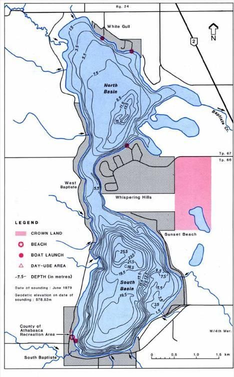
•   Land Use: While focus in the past has largely been on activities near the lake, this watershed
        management plan recognizes the need to understand the cumulative effects of various land
        uses found throughout the watershed that may in turn impact runoff and receiving waterbodies,
        and hence lake health. This includes recreation, lake and country residential development,
        agriculture, transportation and utilities, and industry (forestry, oil and gas, seismic, etc.).
        Understanding how each of these sectors impacts the lake is key, as is understanding how
        regulatory and voluntary best practices can be used to mitigate such impacts.
    •   Climate Variability: Climate variability is another factor that must be considered when
        understanding lake health as well as planning for development projects. While many of Alberta’s
        municipal governments are preparing for climate events such as flood and drought, lake
        managers must also consider the impact of changing temperature and precipitation trends on
        lake water quality and quantity.

In implementing the watershed management plan, it is important to match priorities with available
capacity. Hence an Implementation Committee might initially focus on improved communication and
education, as this need was identified throughout the planning process. In particular, they might focus
communication efforts on ensuring lake users understand existing rules and ensuring such rules are
complied with. They might also ensure rules, such as building setback distances, are consistent between
municipalities. Communicating the results of research and monitoring efforts is also important for
building local knowledge and buy-in for plan actions.

Finally, the success of this plan will be dependent on the partnerships and collaborations generated to
undertake implementation actions. Fortunately, there are few who would dispute the beauty and value
of Baptiste and Island Lakes. Armed with the right information and tools, most are willing to take actions
to protect the lakes, be they visitors, residents, governments or others. This plan helps identify these
needed partnerships and the actions to be undertaken by each party, such that both lakes are healthy
and sustained for current and future generations to enjoy.

                                                    5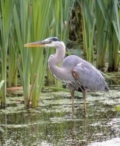
Contents
Baptiste and Island Lakes Stewardship Society ............................................................................................ 2
Acknowledgements....................................................................................................................................... 2
Executive Summary....................................................................................................................................... 3
List of Figures and Tables .............................................................................................................................. 7
Acronyms and Abbreviations ........................................................................................................................ 7
1.0 Introduction ............................................................................................................................................ 8
   1.1 Previous Initiatives .............................................................................................................................. 8
   1.2 Purpose ............................................................................................................................................... 9
   1.3 Methodology..................................................................................................................................... 10
   1.4 Values and Vision .............................................................................................................................. 11
   1.5 Issues to be Addressed ..................................................................................................................... 12
2.0 Key Themes ........................................................................................................................................... 13
   2.1 A Watershed Approach ..................................................................................................................... 13
   2.2 Stewardship ...................................................................................................................................... 24
   2.3 Knowledge......................................................................................................................................... 25
   2.4 Lake Levels ........................................................................................................................................ 26
   2.5 Water Quality .................................................................................................................................... 31
   2.6 Aquatic Ecosystem Health ................................................................................................................ 35
   2.7 Land Use ............................................................................................................................................ 42
   2.8 Climate Variability ............................................................................................................................. 45
3.0 Plan Implementation ............................................................................................................................ 46
In Closing ..................................................................................................................................................... 47
Appendix 1 – WMP Steering and Technical Committee Members (2018) ................................................. 48
Appendix 2 – Resources .............................................................................................................................. 49
Appendix 3 – 5 Year Workplan.................................................................................................................... 53

                                                                                6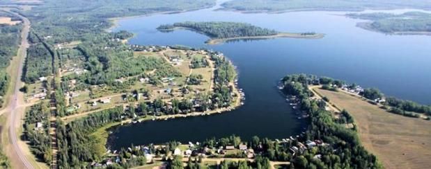
List of Figures and Tables

Figure 1. Baptiste Lake
Figure 2. Baptiste Lake Watershed
Figure 3. Island Lake
Figure 4. Island Lake Watershed
Figure 5. Baptiste and Island Lakes are in the Central Athabasca Upper Sub-watershed
Figure 6. Monthly Temperature Normals, 1981 – 2010
Figure 7. Monthly Precipitation Normals, 1981 - 2010
Figure 8. The average time required to replace the total volume of a lake with inflowing water
Figure 9. Baptiste Lake Evaporation and Precipitation, 1981 – 2010
Figure 10. Baptiste Lake Historical Water Levels, 1971 – 2011
Figure 11. Riparian health rankings for the shoreline of Baptiste Lake
Figure 12. Riparian health rankings for the shoreline of Island Lake
Figure 13. Population growth at Baptiste and Island Lakes, 1985 – 2017

Table 1. Municipalities within the Baptiste and Island Lake watersheds
Table 2. Lake Water Balance Data

Acronyms and Abbreviations
 ALIDP                Alberta Low Impact Development Partnership
 ALMS                 Alberta Lake Management Society
 ALUS                 Alternative Land Use Services Canada
 ATV or OHV           All-terrain vehicle or Off-highway vehicle
 AWC                  Athabasca Watershed Council
 AEP                  Alberta Environment and Parks
 AER                  Alberta Energy Regulator
 BAILS                Baptiste and Island Lakes Stewardship Society
 °C                   Degrees Celsius
 dam3                 Cubic decameter, equivalent to 1,000 cubic metres
 FMA                  Forest Management Area
 GOA                  Government of Alberta
 H2C                  Highway 2 Conservation
 IDP                  Intermunicipal Development Plan
 km or km2            kilometres or square kilometres
 LUB                  Land Use Bylaw
 m or m3              Metres, cubic metres
 mm                   millimetres
 MDP                  Municipal Development Plan
 NSWA                 North Saskatchewan Watershed Alliance
 RMA                  Rural Municipalities of Alberta
 SV                   Summer Villages
 WMP                  Watershed Management Plan

                                                   7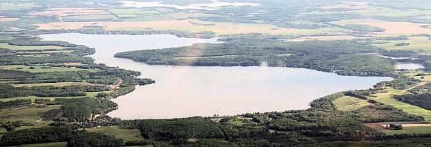
1.0 Introduction

Baptiste Lake (named after an early Métis settler, Baptiste
Majeau) is a moderate‐sized lake located in the County of
Athabasca in central Alberta, situated 165 kilometers (km)
northwest of the City of Edmonton and 16 km west of the
Town of Athabasca. The lake has a number of rural
properties, lake communities, boat launches and
campgrounds on it and is used for recreational fishing,
boating and swimming. The Baptiste Lake watershed (i.e.,
the area of land that drains into the lake) is a mix of
forested crown land and private agricultural lands.

About four km north of Baptiste Lake, Island Lake (so named because of the small islands scattered
throughout the lake), is also valued by residents and visitors for its aesthetics and the recreational
opportunities that it provides. The Island Lake watershed is also largely forested crown land, with some
private agricultural lands and acreages. For a detailed description of both lakes, see the Atlas of Alberta
Lakes, Baptiste and Island Lake pages, which provide descriptions as follows:

    Baptiste Lake Physical Characteristics:                            Island Lake Physical Characteristics:
       • Lake Surface Area = 9.81 km2                                       • Lake Surface Area = 7.81 km2
       • Max Length / Width = 7.48 km / 3.12 km                             • Max Length / Width = 6.2 km / 3.3 km
       • Max / Mean Depth = 27.5 m / 8.6 m                                  • Max / Mean Depth = 18 m / 3.7 m
       • Lake Elevation = 579 m                                             • Lake Elevation = 600 m
       • Lake Volume = ~85,500 dam3                                         • Lake Volume = ~29,066 dam3
       • Watershed Area = 288 km2                                           • Watershed Area = 63.2 km2

Over the past several decades, growing concerns have been raised about Baptiste and Island lakes
including issues such as blue-green algae (cyanobacteria) blooms, high or low lake levels, and poor
fishing. Baptiste Lake has been the subject of many detailed research projects, and a great deal of
technical information is available for this lake (for a short list of some of these resources, see Appendix
2). Island Lake is less well studied although water quality and lake level are measured regularly.

            1.1 Previous Initiatives
Concerns about lake health are not new and Alberta has been looking at the issues affecting these
resources for several decades, going back as early as 1943, when R.B. Miller1 first surveyed Baptiste and
many other Alberta lakes. A growing interest in lake management spurred a great deal of research work
in the 1970s and 1980s in Alberta and elsewhere. These efforts focused on understanding lake

1   Miller, R.B. 1943. Report of a survey of Baptiste Lake conducted July 1943. Report of the Provincial Fisheries Branch. 13 pp.

                                                                   8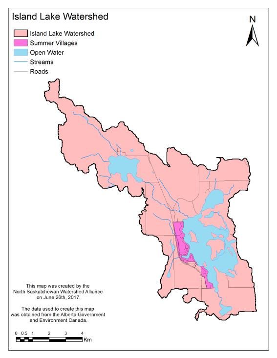
characteristics (e.g. size, depth, biota, etc.), water inputs and outputs (i.e. precipitation,
evapotranspiration, etc.), and factors affecting water quality, quantity and other aspects of lake health.

A good place to access much of this research is the Athabasca University’s Athabasca River Basin
Research Institute Repository which identifies approximately 100 documents that reference Baptiste
and/or Island Lakes. Concerns about the growing intensity of watershed and shoreline development
around Baptiste Lake led to the formation of the Baptiste Lake Property Owners Association in the
1970s, as well as a number of studies, surveys and public hearings to examine this issue. To guide early
development, a Baptiste Lake Preliminary Management Plan was created by Alberta Municipal Affairs in
1978 and an area structure plan was created by Athabasca County in 1979.

From 1976 – 1979, Baptiste Lake was intensively studied by Trew and others 2,3 in order to better
understand its ability to withstand development pressure. This study determined the ‘trophic status’, or
level of biological activity, of the lake by looking at the lake’s limnology, annual phosphorus cycle,
tributary and internal loading, sediment, groundwater, etc. The impact of existing and future shoreline
and watershed development was also examined. With a solid understanding of the lake, later
researchers such as Cooke and Prepas4, continued to examine the impact of activities such as agriculture
and forestry in the uplands surrounding the lake.

Throughout the 1990s and 2000s, researchers continued to study various aspects of these two lakes
including paleolimnology, hydrology, groundwater, fisheries and other biota, nutrient loading, etc.
Although there are fewer early studies for Island Lake, this lake has been a part of the ALMS LakeWatch
Program for more than a decade, with water quality reports available on their website for 2005, 2012
and 2017. Summarizing these earlier works, a state of the lake report was completed for Baptiste Lake in
2008. Similarly, a state of the lake report was completed for Island Lake in 2011.

In 2014, the Baptiste and Island Lakes Stewardship Society (BAILS) was incorporated with the goal of
addressing watershed management issues for both lakes.5 A series of informal meetings was held during
2014 and 2015 to identify individuals willing to investigate a number of shared concerns. BAILS then
approached the North Saskatchewan Watershed Alliance (NSWA) for assistance in developing a
Watershed Management Plan (WMP) that would identify issues and propose solutions for both lakes.

         1.2 Purpose

The Baptiste and Island Lakes Watershed Management Plan (i.e., this report) was prepared via a
collaborative planning initiative conducted by BAILS, the six Summer Villages of both lakes, the County

2 Trew, D.O., D.J. Beliveau and E.I. Yonge. 1978. The Baptiste Lake study summary report. Alta. Envir., Poll. Contr. Div., Water
Qlty. Contr. Br., Edmonton.
3
  Trew, D.O., Beliveau, D.J. & Yonge, E.I. 1987. The Baptiste Lake Study: Technical Report. Alberta Environment, Pollution
Control Division, Water Quality Control Branch. 381 pp
4 Cooke, S.E. & Prepas, E.E. 1998. Stream phosphorus and nitrogen export from agricultural and forested watersheds on the

boreal plain. Canadian journal of Fisheries and Aquatic Sciences, Vol. 55: 2292-2299.
5 Note that in forming, BAILS was provided seed funding from a previous collaboration, the Baptiste, Island and Skeleton Lakes

Stewardship Society.

                                                                9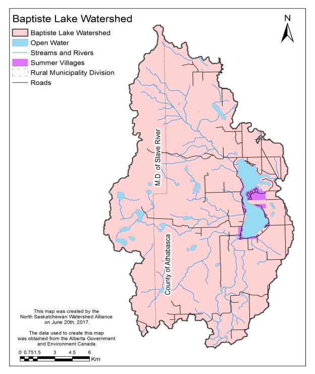
of Athabasca, and other key partners and interested individuals who participated in the process. The
North Saskatchewan Watershed Alliance provided secretariat and technical support.

Although naturally nutrient-rich, Baptiste and Island lakes are both affected by various human activities
that may further contribute to the deterioration of desired natural and aesthetic features. Guidance is
needed to balance these activities, taking into consideration the natural limits and resiliency of both
lakes. The Baptiste and Island Lakes Watershed Management Plan strives to provide this guidance,
providing long‐term direction to maintain the quality of the lakes and their watersheds. This work is
consistent with provincial goals for water management, as detailed in the Government of Alberta’s
Water for Life strategy.

A Lake Watershed Management Plan (WMP) is an action plan to protect, restore and/or enhance the
features that make a lake special and that keep it healthy, for current and future users. Although
watershed management plans are only advisory in Alberta, it is hoped that development and
implementation of the plan will contribute to the following:
    • Identifying and protecting lake values
    • Promoting community discussion and action
    • Knowledge-building of both residents and visitors
    • Establishing environmental and social objectives
    • Setting measurable indicators of lake health
    • Recommending land use policies
    • Guiding stewardship actions including restoration efforts

Plan goals will be achieved through a mix of individual, community, agricultural and industry
stewardship, as well as local and provincial government policy and land use planning. It may also require
regulatory bodies to clarify, harmonize and/or modify existing policies and practices, as well as
implementation of best practices by all stakeholders. The Baptiste and Island Lakes Watershed
Management Plan is a long range, living document (i.e. planning is an iterative and adaptive process)
that will continue to evolve as circumstances and issues change. The scope of the plan includes the
Baptiste and Island Lake watersheds, which includes the two lakes proper, as well as all the lands,
streams and smaller waterbodies (e.g., Ghost Lake) draining into them.

        1.3 Methodology

In developing this WMP, BAILS undertook a number of steps as follows:
    • Developed a project terms of reference (approved by the BAILS Board Dec 9, 2015);
    •   Obtained the Alberta Community Partnership Intermunicipal Collaboration Grant ($25,000) to
        support this work;

                                                     10
• Organized volunteer Steering and Technical Committees from members of the community
(November 2016), which in turn developed workplans and timelines;
• Engaged the lake community by sending out newsletters in June and July, 2015 and hosting
community engagement sessions in May and June, 2017. These sessions documented issues as
well as community aspirations/values for the enjoyment of both lakes and their watersheds;
• Identified several technical projects to address key issues of concern and to inform knowledge
gaps identified in the state of the watershed reports (e.g. riparian health, stream water quality,
status of fisheries, etc.). Working groups were then established to undertake several technical
projects. Two working groups (Water Quality and Riparian Health) presented their findings at a
Public Engagement Session in July 2017; all team results were shared with the public on June 9,
2018; and
• Drafted the watershed management plan including several goals, as well as the strategies and
actions required to achieve goals. A five-year (2019-2024) action plan also identifies potential
action leads, partners and preliminary performance measures.
• Sought feedback on the draft plan (by posting it on the BAILS website, sending a notice to the
BAILS membership, as well as circulating it to the GOA, Indigenous communities in the general
area and other interested parties) before preparing a final document.
1.4 Values and Vision
Throughout the process and again at the February 2018 BAILS Annual General Meeting, participants
discussed their shared values that inform their stewardship actions at both Baptiste and Island lakes.
These can be summarized as:
• Clean water / better water quality / slowing down ‘eutrophication’ (i.e. by limiting nutrients)
• Healthy riparian areas / stable, naturalized shoreline with less erosion and better resiliency to
variable lake levels
• Healthy, sustainable fisheries and other biodiversity
• Responsible lake use by engaged stewards who are compliant with rules and regulations
• Easily accessible public information about what individuals can voluntarily do to protect the
lakes
• A watershed management plan in place to guide actions
From this discussion, a vision to guide the watershed management plan was developed as follows:
Clear water and a natural shoreline in a clean, unpolluted lake that can sustain a variety of
healthy plants and animals, with a balance of recreational use and development, in a well-
managed watershed.
111.5 Issues to be Addressed
Throughout their work, and via their public engagement sessions, the Steering and Technical
committees identified a number of issues standing in the way of achieving their shared vision. These
issues can be grouped into several key areas or themes as follows:
Watershed • To be successful, need to take a holistic approach to lake
management, involving all who live, work or play in the
Approach watershed.
Stewardship • Need to build capacity for stewardship and collaboration.
• Need to continue filling information gaps and building
Knowledge awareness and knowledge through education.
• Need to understand, and be adaptive to, variable lake levels
Lake Level and stream flows.
• Need to maintain water quality by restricting activities that
Water Quality contribute nutrients and pollutants to the lake.
Aquatic • Need to maintain healthy aquatic ecosytems and the species
that inhabit them in the lakes, streams, wetlands, and
Ecosystem Health riparian areas found throughout the watersheds.
• Need to understand the cumulative effects of various land
Land Use uses and mitigate their impact on runoff and receiving
waterbodies.
• Need to understand and be prepared for climate variability
Climate Variability including drought, flood and wild fire events that affect lake
conditions.
These key themes make up the body of the watershed management plan and are discussed in more
detail in the next sections. For each theme, the plan looks at:
• What is the issue?
• What is known about it?
• What can be done about it? Note that the goals, strategies and actions discussed below apply to
both Baptiste and Island lakes, unless otherwise noted.
122.0 Key Themes
2.1 A Watershed Approach
What is the issue?
Baptiste and Island lakes, like many Alberta waterbodies, are highly valued by the people who live at or
visit these lakes, and for a variety of reasons such as aesthetics, recreation, rural living, connecting to
nature, etc. Hence it is no surprise that lake users want to see these values maintained, both today and
in perpetuity. That is, Albertans want to see the lake resource managed, with the same care and
attention we manage our other natural resources.
Over the past several decades, lake managers have come to understand that lakes cannot be managed
in isolation of what occurs around them. Hence, more and more, a watershed approach is required. The
watershed of a lake includes all of the land that drains into it. Activities on the land can affect how water
(via runoff, groundwater and tributary flows) drains to the lake, in turn, determining lake level, water
quality, and other lake characteristics.
Jurisdiction for watershed management in Alberta is held by several land and water authorities,
including municipal, provincial, and federal governments. The way in which Baptiste and Island Lakes are
managed and protected is a concern to many area stakeholders. Concerns identified during stakeholder
engagement related to a lack of policy alignment between jurisdictions, lack of long-term land use
planning to maintain lake sustainability, limited enforcement of regulations and inadequate funding for
lake watershed management.
What do we know about it?
Baptiste Lake is a moderate sized Alberta lake with a surface area of 9.81 square kilometers (km2). It has
two distinct basins joined by a shallow (less than 6 m) narrows (Figure 1). The basins are of similar size;
the north basin is shallow (with a maximum depth of 16 m), whereas the south basin is deeper (27.5 m
maximum depth). The Baptiste Lake watershed is about 30 times (288 km2) the size of the lake (Figure
2). The watershed includes 12 tributary streams (sub-watersheds) which drain 92% of the watershed
into the lake (the remaining 8% of the watershed drains directly from the land to the lake by way of
diffuse runoff).
Island Lake is also a moderately sized Alberta Lake (Figure 3) with a surface area of a little less than 8
km2. It also has two distinct basins: a fairly shallow main basin (6 – 12 m deep) and a smaller, deeper
north basin (maximum depth 18 m). The Island Lake watershed is about eight times the size of the lake
(about 63 km2), mostly to the north and west of the lake (Figure 4).6 Island Lake receives flows from
Ghost Lake (which drains 37% of the watershed), as well as a number of smaller seasonal creeks that
drain the remainder of the watershed.
6
For more detailed descriptions of Baptiste and Island Lake watersheds, see the Atlas of Alberta Lakes.
13Figure 1. Baptiste Lake – Bathymetry (Source: Mitchell, P. and Prepas E. “Atlas of Alberta Lakes”, University of
Alberta Press, January 1990.
14Figure 2. Baptiste Lake Watershed
15Figure 3. Island Lake – Bathymetry (Source: Mitchell, P. and Prepas E. “Atlas of Alberta Lakes”, University of
Alberta Press, January 1990.
16Figure 4. Island Lake Watershed
17Both Baptiste and Island lakes outflow to the Athabasca River (via Baptiste and Island creeks,
respectively), just before it flows through the Town of Athabasca. These two lake watersheds are
located in the ‘Upper Central Athabasca Sub-watershed’, one of nine sub-watersheds that make up the
Athabasca River watershed (Figure 5).7 This area is a part of the Boreal Forest Natural Region, with a
cold, sub-humid continental climate. Winters are long and cold. Summers are short and warm (Figure
6). Annual precipitation (1981 – 2010) is about 460 mm, although it has varied from 304 mm (2015) to
607 mm (1988). Most precipitation falls in June and July. About 25% falls as snow between late October
through to mid-April (Figure 7).8
Provincially, there are a number of policies (e.g. Water for Life, Land Use Framework, Alberta’s Wetland
Policy, etc.), pieces of legislation (e.g. Water Act, Public Lands Act, Environmental Protection and
Enhancement Act, Municipal Governments Act, etc.), and guidance documents (e.g. Stepping Back from
the Water) that influence aspects of watershed management in Alberta.9 The Water for Life strategy
recognizes the need to take a watershed approach and promotes understanding through The Water
Channel and Water Literacy survey. As a part of Water for Life work, Alberta Environment and Parks
(AEP) engaged Albertans in a discussion about lake management via the ‘Water Conversations’. They
also sought advice on lake watershed management via the multi-stakeholder Alberta Water Council
process (see their lake watershed management project page).
Regionally, the Athabasca Watershed Council (AWC) was formed to work towards achieving the Water
for Life goals in the Athabasca River watershed. This multi-stakeholder, not-for-profit organization,
formed in 2009, is one of 11 Watershed and Planning Advisory Councils created in the province to give
sectors and people living, working and playing in each watershed an opportunity to participate in
watershed assessment and management planning. The work of the AWC is guided by its vision: The
Athabasca watershed is ecologically healthy, diverse and dynamic. The AWC has just (2018) initiated
work on a watershed management plan that will further define what this vision means for surface and
ground water quality and quantity, as well as for aquatic ecosystem health in the Athabasca watershed.
In the meantime, the AWC has been, and will continue to be, supportive of sub-basin and lake
watershed assessment and planning initiatives throughout the Athabasca basin.
Baptiste and Island Lakes also fall within Alberta’s Land Use Framework’s Upper Athabasca Region. As of
yet (2018), there is no regional plan for this area. However, the Lower Athabasca Regional Plan provides
guidance in that it has led to the development of management frameworks for surface and ground
water quantity and quality. Similarly, work to date on the North Saskatchewan Regional Plan to the
south recognizes the importance of lakes for recreation and other human uses, as well as for their role
in maintaining hydrological function in the watershed.
7
For more information about the Athabasca watershed, see About the Athabasca River Basin on the Athabasca
River Basin Research Institute (ARBRI) webpage.
8
S. Figliuzzi and Associates. 2018. Water Balance for Baptiste Lake, Alberta , submitted to NSWA, April, 2018.
9
For an overview of lake legislation, see the Recommendations for Lake Watershed Management in Alberta
produced by the Alberta Water Council.
18Figure 5. Baptiste and Island Lakes are in the Central Athabasca Upper Sub-watershed, one of nine sub-
watersheds that contribute to the Athabasca River in Alberta.
19Figure 6. Monthly Temperature Normals, 1981 – 2010 (Source: S. Figliuzzi, April 2018)
Figure 7. Monthly Precipitation Normals, 1981 – 2010 (Source: S. Figliuzzi, April 2018)
20Recent provincial changes to the Municipal Government
An objective of the Athabasca County
Act (MGA) support efforts by Alberta’s municipalities to
Municipal Development Plan (2008) is
balance development around lakes and other
to “maintain the existing residential
waterbodies. For the most part, Baptiste and Island Lakes
environments around those lakes in
(and their watersheds) fall within the County of Athabasca
the County which have experienced
and there are several properties, as well as the
extensive residential development in
unincorporated communities of White Gull Beach and
the past, and to not allow residential
Poplar Point, under County jurisdiction around both lakes.
development around those lakes
which would reduce the quality of the
The County has a number of policies and bylaws to govern
residential environments or change
development within its boundaries including a Municipal
the natural environments (including
Development Plan (MDP) and a Land Use Bylaw (LUB).
trophic status) of those lakes.”
These documents include several statements favorable to
balancing development, recreation and other activities
around Baptiste, Island and other lakes in the county. In particular, they can take environmental reserve
at the time of subdivision; limit building within 30 m of the lake shoreline; and require development
applicants to minimize disturbance of the shoreline vegetation and aquatic life. Note that the far
western portion of the Baptiste Lake watershed, where a number of tributary headwaters are located,
falls within the Municipal District of Lesser Slave River.
Summer Villages also play an important role in managing development around Baptiste and Island lakes.
Baptiste Lake has four summer villages around its shoreline. Island Lake has two summer villages (Table
1). Similar to the County, Summer Villages have a number of policy and regulatory documents that
balance development and lake health. For example, most have the ability to designate environmental
reserve at subdivision; require building setbacks from shore-facing property lines (although definitions
and distances vary between summer villages); limit the percentage of the lot that can be developed
and/or cleared of trees/vegetation (again, percentages vary); and some limit development in a
floodplain or highly sloped area or that would have an adverse effect on lake water quality or on the
aesthetics of the lakeshore.
21Table 1. Municipalities in and around the Baptiste and Island Lake watersheds.
Municipality Description Key Documents:
Athabasca County Incorporated as a county in 1945. Municipal Development Plan (includes a
Population 7,869 (2016). Responsible for Lakeshore Management Areas Policy),
county lands around the lake. Land Use Bylaws, Town & County
Intermunicipal Development Plan
Summer Village of Incorporated 1977. Located on the east Land Use Bylaw; draft sewage bylaw;
Sunset Beach shore of Baptiste Lake. 130 properties. OHV Bylaw
Resident population 49 (2016).
Summer Village of Incorporated 1983. Located on the south Land Use Bylaw, Sewage Bylaw
South Baptiste shore of Baptiste Lake. 89 properties.
Resident population 66 (2016).
Summer Village of Incorporated 1983. Located on the east Land Use Bylaw; Sewage Bylaw
Whispering Hills shore of Baptiste Lake. 214 properties.
Resident population 142 (2016).
Summer Village of Incorporated 1982. 120 properties Land Use Bylaw; Sewage Bylaw
West Baptiste located along the west shore of Baptiste
Lake. Resident population 38 (2016). The
village has its own recreational building
combined with a firehall.
Summer Village of Incorporated 1957. 287 residences. Land Use Bylaw; Sewage Bylaw; Bylaw to
Island Lake Accessible from Highway 2. Located on Prohibit Clearing of Lots
the west shore of Island Lake. Resident
population 228 (2016).
Summer Village of Incorporated 1983. 105 residences. Land Use Bylaw; Sewage Bylaw
Island Lake South Accessible from Highway 2 located on
the south shore of Island Lake. Resident
population 61 (2016).
White Gull Was previously a summer village: now Managed under Athabasca County’s
(unincorporated) administered by Athabasca County Municipal Development Plan and Land
Use Bylaw
Town of Athabasca Incorporated as a town in 1911. Land Use Bylaw (2015); Municipal
Population 2,965 (2016). No Development Plan
management authority but lake used by
town residents for recreation.
22What can we do about it?
BAILS has taken an important first step in addressing the fragmented nature of lake management by
recognizing the need to take a watershed approach. Going forward, they can continue to promote this
approach to other land and water managers and decision-makers in the Baptiste and Island lake
watersheds. A watershed management plan that is accepted by provincial and local governments will
bring alignment as it is implemented. In turn, the WMP can also inform other municipal, regional and
provincial planning initiatives.
The Issue: Watershed management roles and responsibilities are fragmented with limited integration
between land and water. There is also limited policy and planning alignment between and among the
provincial government and municipalities managing lakes and watersheds. To be successful, lake
management requires land and water managers to take a holistic and integrated approach to managing
cumulative impacts, involving all who live, work or play in the watershed.
Goal: The Baptiste and Island watersheds are recognized as critical to lake health and Lead/ Partners
managed in an integrated, collaborative manner by the provincial and municipal
governments.
Strategies: Develop a watershed management plan implementation committee to BAILS /
oversee and report on WMP implementation progress. Stakeholders
Submit the WMP to the GOA and the Athabasca Watershed Council BAILS / GOA (AEP),
and ask for recognition of this advisory plan, as well as recognition of AWC
the need for lake watershed management, in future planning
documents including the Upper Athabasca Regional Plan and
Athabasca Integrated Watershed Management Plan, when they are
developed.
Submit the plan to M.D. of Lesser Slave River, Athabasca County and BAILS / Athabasca
the 6 Summer Villages on Baptiste and Island lakes and ask them to County, 6 Summer
formally acknowledge the plan in their policy and planning documents, Villages, M.D. LSR
as such documents are developed or renewed.
Review and align Intermunicipal Development Plans, Municipal Athabasca County
Development Plans, Land Use Bylaws and other policies such that /6 Summer Villages
development rules (e.g. setback distances, lot coverage, tree clearing
policies, etc.), incorporate best management practices and are
consistent around both lakes.
232.2 Stewardship
What is the issue?
Baptiste and Island Lakes already have a small engaged community of lake stewards willing to work
towards maintaining lake health. The need for a strong stewardship community and collaboration with
others were common themes heard throughout the WMP development process. However, maintaining
and growing this stewardship community requires both financial and human capacity.
What do we know about it?
Long-time residents and users of Baptiste and Island lakes have significant knowledge and insight into
the history and condition of the lakes and their watersheds and the problems both lakes experience. All
residents and users of the two lakes should have a voice in determining the long-term future of the
lakes; as well, they can play a meaningful role in lake watershed management. Currently, however,
there is limited community involvement and participation in promoting environmentally-responsible
stewardship. Additionally, BAILS has limited resources for implementing watershed management actions
such as water quality monitoring, research, education and outreach, etc. to inform stewardship actions.
What can we do about it?
Going forward, it is important to recognize that lake watershed management is a long-term
commitment and changes in behaviour and lake health won’t occur overnight. Hence it is important that
the WMP identify priorities and that the Implementation Committee and its partners choose a few key
actions it can make progress on, versus a lot of things it doesn’t have the capacity for. In the meantime,
there are a number of provincial resources and water-related programs that the Committee can draw on
to help leverage its efforts (some of these are listed in Appendix 2 – General Watershed Resources).
The Issue: Building and maintaining an engaged stewardship community takes human and financial capacity.
Additionally, funding for research, monitoring and other management activities is required.
Goal: The Implementation Committee is adequately resourced to undertake its work. Lead
Strategies: Solicit grants and in-kind support for studies, staffing, events, etc. via innovative BAILS
community collaboration and funding initiatives, municipal and government grant
programs (e.g. AEP Watershed Restoration and Resiliency Program, ECCC
Environmental Damages fund), industry in-kind support, etc.
Leverage resources by partnering with existing programs such as Alberta Lake BAILS/
Management Society’s Lake Watch, Living by Water, Cows and Fish, Highway 2 lake
Conservation, AEP Respect our Lakes program, etc. programs
Goal: Stewardship initiatives are well-supported by the community and other stakeholders in the Lead
watershed.
Strategies: Increase participation in WMP implementation activities by engaging residents, BAILS
industry, youth, etc. and celebrating successes. (See more actions to support this
strategy in Appendix 3 – Five Year Implementation Strategy.)
242.3 Knowledge
What is the issue?
A lack of information, knowledge and education was a common theme mentioned throughout the WMP
process. Researchers have pointed out where there are data and information gaps. Stakeholders voiced
concern over a lack of understanding within the community about how human activities affect the lakes
and their watersheds, as well as misconceptions around what a healthy lake looks like. They also
recognized the importance of education in improving awareness about lake health and management
and towards creating an engaged local community of watershed stewards.
What do we know about it?
Throughout the WMP process, BAILS has worked to gather both existing and new information about
Baptiste and Island Lakes, in order to improve understanding about lake health. BAILS has also shared
this information with others, via its website, member meetings and public engagement sessions, in
order to build knowledge and understanding, among those who live, work or play in the watershed.
What can we do about it?
When asked, stakeholder aspirations and solutions were overwhelmingly in support of increasing
watershed and lake education (and information-sharing) within the community, including stakeholders
and the general public. In particular, education should focus on what people can do to contribute to
achieving and maintaining healthy lake ecosystems. As well, it should focus on educating stakeholders
on the environmentally sustainable use of public lands surrounding Baptiste and Island Lakes. To do this,
BAILS can tap into a number of existing online and other resources such as the GOA’s Respect Our Lakes
program.
The Issue: Information and knowledge about lake issues and how human activities affect lakes and their
watersheds, is not always easily available or widely disseminated. As well, people have misconceptions about
what a healthy lake looks like and what they can do to protect the lakes.
Goal: Those that live, work or play in the Baptiste and Island Lake watersheds are knowledgeable Lead
about lake health and know what they can do to reduce their impact.
Strategies: Educate targeted audiences (youth, property owners, etc.) about lake health and the BAILS
WMP using existing programs such as ALMS, Respect Our lakes, AEP’s Water Literacy
program, etc. (See more about creating a communications committee and plan
under actions in Appendix 3.)
Partner with academia and other lake/stewardship groups to promote education
through citizen science projects.
Develop a Resident Information Kit and distribute to lake users via the Summer
Villages, Town and County offices, realtor offices, etc.
252.4 Lake Levels
What is the issue?
Lake water levels rise and fall throughout the seasons and over the years in response to the local
weather and overall climate conditions. Water levels for a number of Alberta lakes, including Baptiste
and Island lakes, were summarized by Buendia and Trew (2017)10 for the period 1985 to 2016. This
summary shows both Baptiste and Island lakes having periods where the lake level was below average,
as well as periods above average. Despite this natural variability, water levels at Baptiste and Island
Lakes are an ongoing concern for lake residents. In particular, water levels at Baptiste Lake, much below
normal a decade ago, have been high in recent years, according to lake users. Water levels at Island Lake
fell more than one metre in the late 1990s, but have been slowly returning to normal in recent years.
High water can erode the shore and increase the risk of wave and ice damage to shoreline properties
and infrastructure built too close to the high-water mark.11,12 This is why many subdivision
developments either have a 30 m environmental reserve or require a minimum building setback from
the shore-facing property line. High water levels can have both positive and negative impacts on water
quality. In areas with healthy shorelines, flooding can revitalize biological productivity and diversity.
However, in areas with shoreline degradation, flooding can increase erosion. Conversely, low water
levels can affect water quality as lake flushing may occur more slowly in low water years.
What do we know about it?
Many factors contribute to fluctuating lake water levels. Water levels at Baptiste and Island lakes
naturally vary a great deal between seasons. High water often occurs in the spring as the snow melts
across the landscape and runoff is carried to the lakes via several small streams. At this time of year, the
volume of water coming into a lake can exceed the volume exiting, resulting in high water and
sometimes flooding of properties too close to the shoreline. High summer rainfall events can result in
similar problems. Increasing summer temperatures with high evaporation usually draw down and
resolve flooding issues, but can affect summer recreation and aesthetics if a lake becomes too low. Lake
level can also affect water temperature and other aspects of water quality and aquatic ecosystem
health.
The ratio of drainage basin area to lake area is an important factor influencing lake level. Lakes with
proportionately large drainage basins usually receive more runoff, so the lake volume may exceed the
capacity of the lake outflow, causing a rise in lake water levels. Baptiste Lake has a large drainage area of
approximately 291 km2 in relation to its lake surface area (about 9 km2), more than 30 times the area of
the lake. Hence it receives a large inflow of water from its 12 creeks and many diffuse runoff areas that
drain directly into the lake. The lake has a re-filling time of about five years and is considered “well
flushed’ compared to other Alberta Lakes (Figure 8). Island lake has a smaller watershed to lake ratio
10 See C. Buendia and D. Trew. 2017. NSWA Technical Bulletin: Lake Level Trends in Alberta – Preliminary Results.
11 For more information on what residents can do during and after high lake level events, please see Alberta Environment and
Parks High Water and Lakeshores webpage.
12 High Water Mark is defined in Stepping Back from the Water as “the usual or average level to which a body of water rises at
its highest point and remains for sufficient time so as to change the characteristics of the land….”
26(about 6:1), and fewer streams, but because it is relatively shallow (low lake volume), it also has a rapid
re-filling time of about 4 to 5 years.
120
100
Number of Years
80
60
40
20
0
Figure 8. The average time required to completely replace the total volume of a lake with inflowing water.
(Source: Mitchell, P. and E. Prepas. 1990. The Atlas of Alberta Lakes, University of Alberta Press.)
Precipitation patterns may change in the future depending on how climate change affects this region. In
recent years, watersheds in Athabasca County have experienced higher than average precipitation. In
particular, the County received an extreme level of precipitation in July 2017 (222.5 mm)13, about three
times the amount of rainfall normally received (~ 70 mm) in the area for that month. In general,
however, gross evaporation exceeds precipitation during most of the year (Figure 9).14
Runoff can also be influenced by soil moisture. When the soil is saturated and rain continues to fall, the
rainfall will immediately produce surface runoff. This was seen at Baptiste Lake in 2017, after the July
precipitation event when soils became saturated, stream flow was high and lake water levels responded
to these wet conditions. Natural features, such as wetlands and riparian areas, can help soak up excess
waters, slowing water release over time.
Despite this natural variability, looking over the long term, data (from 1972 – 2009) suggests that water
volumes have been fairly stable at Baptiste Lake. Average water level is 578.296 m, with a maximum of
579.199 m (July 1986) and a minimum of 577.842 m (October 2009): all told, a variance of 1.5 m. Note
that when high water levels occur, the outlet is usually able to pass large quantities of water rapidly (if
large amounts of debris and/or beaver dams are not present) and high-water periods are usually fairly
short-lived (Figure 10). Lake level data is important for evaluating trends and developing lake water
balances and outflow rating curves.
13
For more information about high water levels, see this Information Sheet developed by the Summer Village of
South Baptiste.
14
S. Figluizzi Water Balance Presentation to the BAILS Technical Committee, April 13, 2018.
27Figure 9. Baptiste Lake Evaporation and Precipitation, 1981 – 2010 (Source: S. Figliuzzi, April 2018)
Mean 578.296
m
Figure 10. Baptiste Lake Historical Water Levels, 1971 – 2011 (Source: S. Figliuzzi, April 2018). Note that lake
level monitoring was discontinued in 2011 but will be resumed in 2019.
Lake level data reviewed by Buendia and Trew (2017) for Island Lake (1968-2016) showed below
average levels from 1998 – 2008, when the level dropped by almost a metre. This period seemed to
28correspond with lower precipitation in the Athabasca region. Since then, lake levels have returned to
normal, averaging about 601 m above sea level (minimum 600.7 m; maximum 601.6 m).
Lake levels can also be influenced by obstructions
that slow water outflows, such as beaver dams, or
plugged culverts. Beavers provide many ecological
goods and services and are a natural part of aquatic
ecosystems.15 However, they can also slow flows at
lake outlets that then back up lake levels (if the dam
is higher than the lake level), in turn, affecting
infrastructure. Alternatively, beaver dams can be
beneficial on inflowing tributaries (holding back and
then slowly releasing waters) and in periods of low
lake levels, effectively acting as weirs and slowing
the fall of lake levels in late summer.
Lake levels can also be affected by water withdrawals. At this time, there are only a few licenced water
withdrawals in the Baptiste watershed. As well, there may be a small number of domestic users (not
requiring a licence). Similarly, the Island Lake watershed has only a handful of licences for water
withdrawals. Overall, water withdrawals are likely not a large issue at either lake at the present time but
could warrant a closer look in the future, if it becomes a bigger portion of the overall water balance
(Table 2) of either lake. A water balance was completed recently for Baptiste Lake (Sal Figliuzzi and
Associates 2018). A full water balance has not been completed for Island Lake although some figures are
available in the Island Lake state of the watershed report (see Carlson, 2011) and in Trew et al. 1987.
Note that as well as receiving water from precipitation and surface flows, both lakes also have a
groundwater connection.
Table 2 - Lake Water Balance Data
INPUTS Baptiste Lake (average dam3/year) Island Lake (average dam3/year)
Precipitation 4,408 3,990
Surface Inflow 19,109 2,830
Groundwater Inflow 2,766 Small; 4%
Sub-Total 26,283 6,720
OUTPUTS
Evaporation 6,123 5,000
Surface Outflow 17,930 unknown
Groundwater Outflow 2,766 small
Allocation Diversion Use 21 Small
Sub-Total 26,840
What can we do about it?
When asked, stakeholders indicated the importance of maintaining adequate lake water levels, ensuring
the investment potential of their properties, and minimizing lake erosion. In order to be prepared for
15
For more information, see Cows and Fish’s Beavers- Our Watershed Partner or the AEP Beaver webpage.
29You can also read