Port Procedures and Information for Shipping - Whitsundays - May 2018 - Maritime Safety Queensland
←
→
Page content transcription
If your browser does not render page correctly, please read the page content below
Port Procedures and Information
for Shipping – Whitsundays
May 2018
Creative Commons information
© State of Queensland (Department of Transport and Main Roads) 2017

http://creativecommons.org.licences/by/4.0/
This work is licensed under a Creative Commons Attribution 4.0 Licence. You are free to copy,
communicate and adapt the work, as long as you attribute the authors.
The Queensland Government supports and encourages the dissemination and exchange of
information. However, copyright protects this publication. The State of Queensland has no objection
to this material being reproduced, made available online or electronically but only if its recognised as
the owner of the copyright and this material remains unaltered.
            The Queensland Government is committed to providing accessible services to
            Queenslanders of all cultural and linguistic backgrounds. If you have difficulty
            understanding this publication and need a translator, please call the Translating and
            Interpreting Service (TIS National) on 13 14 50 and ask them to telephone the Queensland
            Department of Transport and Main Roads on 13 74 68.
Disclaimer: While every care has been taken in preparing this publication, the State of Queensland
accepts no responsibility for decisions or actions taken as a result of any data, information, statement
or advice, expressed or implied, contained within. To the best of our knowledge, the content was
correct at the time of publishing.

Hard copies of this document are considered uncontrolled. Please refer to the Maritime Safety Queensland website for
the latest version. Port Procedures and Information for Shipping – Whitsundays – May 2018
Contents
List of tables ................................................................................................................................ 6

List of figures ............................................................................................................................... 6

Table of Amendments ................................................................................................................. 7

Section 1          Introduction ............................................................................................................. 8
              General........................................................................................................................... 8
              Purpose .......................................................................................................................... 8
              Datum ............................................................................................................................. 9
              Authorities ...................................................................................................................... 9
              Definitions .................................................................................................................... 10
1.5.1         Australian Maritime Safety Authority (AMSA) .............................................................. 10
1.5.2         MASTREP — Modernised Australian Ship Tracking and Reporting System .............. 10
1.5.3         Great Barrier Reef Marine Park Authority (GBRPMA) ................................................. 10
1.5.4         Highest astronomical tide (HAT)/Lowest astronomical tide (LAT) ............................... 10
1.5.5         International Maritime Organization (IMO) ................................................................... 10
1.5.6         Maritime Safety Queensland (MSQ) ............................................................................ 10
1.5.7         Overall length (LOA) .................................................................................................... 11
1.5.8         REEFREP .................................................................................................................... 11
1.5.9         Reef VTS ...................................................................................................................... 11
1.5.10        Regional Harbour Master (RHM) ................................................................................. 11
1.5.11        Whitsundays Plan of Management (WPOM) ............................................................... 11
              Contact information ...................................................................................................... 11
1.6.1         The Regional Harbour Master ...................................................................................... 11
1.6.2         Great Barrier Reef Marine Park Authority .................................................................... 11
1.6.3         Hamilton Island Marina ................................................................................................ 11
1.6.4         Reef VTS ...................................................................................................................... 12
1.6.5         Marine authorities ......................................................................................................... 12

Section 2          Whitsundays pilotage area .................................................................................. 13
              Pilotage area ................................................................................................................ 13
              Compulsory pilotage area ............................................................................................ 13
              Applicable vessels ........................................................................................................ 14

Section 3          Movement and traffic procedures ....................................................................... 15
              General......................................................................................................................... 15
              Vessel Traffic Service (VTS) ........................................................................................ 15
3.2.1         Information Service (INS) ............................................................................................. 15
3.2.2         Traffic Organisation Service (TOS) .............................................................................. 15
3.2.3         Navigational Assistance Service (NAS) ....................................................................... 15
              Prior notification of movement ..................................................................................... 16
3.3.1         QSHIPS (Queensland Shipping Information Planning System) .................................. 16
              Booking a vessel movement ........................................................................................ 16
              Arrival reporting requirements ...................................................................................... 17
              Departure reporting requirements ................................................................................ 17
              Tug and tow transiting the GBRMPA Compulsory pilotage area. ................................ 17
              Cruise ship anchorage applications ............................................................................. 17

Hard copies of this document are considered uncontrolled. Please refer to the Maritime Safety Queensland website for the
latest version. Port Procedures and Information for Shipping – Whitsundays – May 2018                                                                 3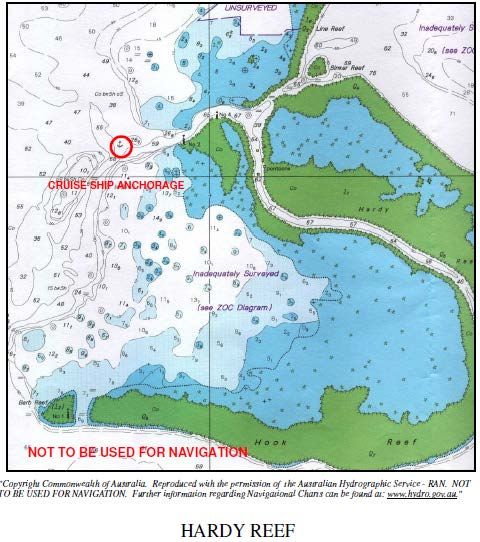
MASTREP .................................................................................................................... 18
Reporting defects ......................................................................................................... 18
Section 4 Cruise ship anchorages ....................................................................................... 19
General......................................................................................................................... 19
Pilotage ........................................................................................................................ 19
Fitzalan anchorage....................................................................................................... 19
4.3.1 Environmental issues: .................................................................................................. 20
4.3.2 Application and voyage plan for Fitzalan Anchorage ................................................... 20
4.3.3 Maximum length of ship ............................................................................................... 21
4.3.4 Minimum manoeuvring equipment ............................................................................... 21
4.3.5 Navigation Information for Fitzalan Anchorage ............................................................ 21
4.3.6 Anchorage details ........................................................................................................ 22
4.3.7 Navigation aids ............................................................................................................. 22
4.3.8 Geographic location ..................................................................................................... 23
4.3.9 Anchoring practices ...................................................................................................... 23
4.3.10 Recommended anchorage position ............................................................................. 23
4.3.11 Swinging room ............................................................................................................. 23
4.3.12 Swinging limits ............................................................................................................. 24
4.3.13 Marshalling craft ........................................................................................................... 24
4.3.14 Tidal information and controlling depth ........................................................................ 25
4.3.15 Entry and departure track information.......................................................................... 26
4.3.16 Standby requirements .................................................................................................. 29
4.3.17 Chart and position-fixing requirements ........................................................................ 29
4.3.18 Limited period access .................................................................................................. 30
Hardy Reef anchorage ................................................................................................. 30
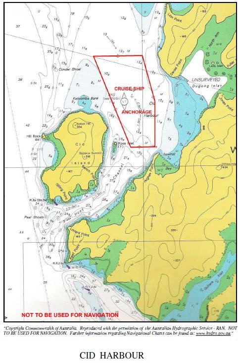
CID Harbour anchorage ............................................................................................... 31
Turtle Bay anchorage ................................................................................................... 34
South East Hamilton anchorage .................................................................................. 36
Recreational vessels — restricted areas and activities ............................................... 37
Sewage pump-out facilities .......................................................................................... 38
Resorts ......................................................................................................................... 38
4.10.1 Hamilton Island ............................................................................................................ 38
4.10.2 Hayman Island ............................................................................................................. 39
4.10.3 Daydream Island .......................................................................................................... 39
4.10.4 Hook Island .................................................................................................................. 39
4.10.5 Lindeman Island ........................................................................................................... 41
4.10.6 South Molle Island........................................................................................................ 41
4.10.7 Laguna Whitsundays .................................................................................................... 42
Reefs and reef pontoons .............................................................................................. 42
4.11.1 Hardy Reef ................................................................................................................... 43
4.11.2 Bait Reef ...................................................................................................................... 43
4.11.3 Knuckle Reef ................................................................................................................ 43
4.11.4 Disclaimer .................................................................................................................... 43
Section 5 General information .............................................................................................. 45
Charts and books ......................................................................................................... 45
Shipping announcements ............................................................................................ 45
Differential global positioning system (DGPS) Service ................................................ 45
Volunteer Marine Rescue (VMR) Whitsunday and Mackay......................................... 46
Speed restrictions ........................................................................................................ 46
Hard copies of this document are considered uncontrolled. Please refer to the Maritime Safety Queensland website for the
latest version. Port Procedures and Information for Shipping – Whitsundays – May 2018 4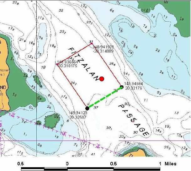
Navigation information ................................................................................................. 47
5.6.1     Vessels underway ........................................................................................................ 47
5.6.2     Under keel clearance ................................................................................................... 47
5.6.3     Specific problem areas................................................................................................. 48
          Aids to navigation ......................................................................................................... 49
5.7.1     Radio and electronic aids ............................................................................................. 50
          Anchoring ..................................................................................................................... 50
5.8.1     ‘No anchoring’ areas .................................................................................................... 50
          Buoy moorings ............................................................................................................. 51

Section 6     Weather information ............................................................................................. 52
          General......................................................................................................................... 52
6.1.1     Extreme Weather Event Contingency Plan.................................................................. 52
6.1.2     Cyclone procedures - Abel Point Marina ..................................................................... 52
6.1.3     Cyclone procedures — Port of Airlie Marina ................................................................ 52
          Tidal information ........................................................................................................... 53
6.2.1     Tidal information — Tsunami effects ........................................................................... 53

Section 7     Dangerous cargo................................................................................................... 54
          General......................................................................................................................... 54
7.1.1     Notification ................................................................................................................... 54
          Dangerous cargo events .............................................................................................. 54
          Reporting requirements for local marine services ....................................................... 55

Section 8     Emergency pollution marine incidents ............................................................... 57
          General......................................................................................................................... 57
          Emergency contact numbers ....................................................................................... 57
          Marine pollution ............................................................................................................ 57
8.3.1     Reporting ...................................................................................................................... 58
8.3.2     Waste disposal ............................................................................................................. 58
8.3.3     Sewage ........................................................................................................................ 58
          Marine incidents ........................................................................................................... 60
8.4.1     Marine incident reporting.............................................................................................. 60
8.4.2     Marine incident reporting — AMSA .............................................................................. 61
          Great Barrier Reef Marine Park Authority incident report form .................................... 61

Section 9     Appendices ............................................................................................................ 62
          Whitsunday reporting area - pre-arrival report ............................................................. 63
          Form 1 - Fitzalan Anchorage - Application for technical assessment.......................... 64
          Form 2 - Fitzalan Anchorage - Application to visit ....................................................... 65
          Form 3 - Fitzalan Anchorage - Voyage plan ................................................................ 66
          Hamilton Island request form ....................................................................................... 67
          Whitsundays Pilotage area .......................................................................................... 68

Hard copies of this document are considered uncontrolled. Please refer to the Maritime Safety Queensland website for the
latest version. Port Procedures and Information for Shipping – Whitsundays – May 2018                                                           5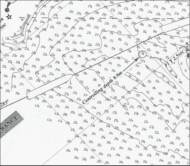
List of tables
Table 1 – Marine authorities ........................................................................................................ 12
Table 2 – Prior notification of movement ..................................................................................... 16
Table 3 – Navigation aids ............................................................................................................ 22
Table 4 – Fitzalan Anchorage swinging circles ........................................................................... 24
Table 5 – Hardy Reef anchorage information ............................................................................. 30
Table 6 – Cid Harbour anchorage - information .......................................................................... 32
Table 7 - Turtle Bay anchorage - information .............................................................................. 34
Table 8 – South East Hamilton anchorage - information ............................................................ 36
Table 9 – Hamilton Island information .................................................................................... 38
Table 10 – Hayman Island information .................................................................................... 39
Table 11 – Daydream Island information ................................................................................ 39
Table 12 – Hook Island information ......................................................................................... 40
Table 13 – Lindeman Island information ................................................................................. 41
Table 14 – South Molle Island information ............................................................................. 41
Table 15 – Laguna Whitsundays information ......................................................................... 42
Table 16 – Reef and reef pontoons .......................................................................................... 42
Table 17 – Bait Reef information .............................................................................................. 43
Table 18 – Disclaimer ................................................................................................................ 43
Table 19 – Tidal information ..................................................................................................... 53
Table 20 – Movement Notification ........................................................................................... 54
Table 21 – Emergency contact numbers................................................................................. 57

List of figures
Figure 1 – Anchorage details....................................................................................................... 22
Figure 2 – Entry/departure track into Fitzalan Anchorage........................................................... 26
Figure 3 – Fitzalan Anchorage – Henning Entrance ................................................................... 27
Figure 4 – Henning Entrance....................................................................................................... 28
Figure 5 – Henning Entrance – Head mark ................................................................................. 28

Hard copies of this document are considered uncontrolled. Please refer to the Maritime Safety Queensland website for the
latest version. Port Procedures and Information for Shipping – Whitsundays – May 2018                                                       6
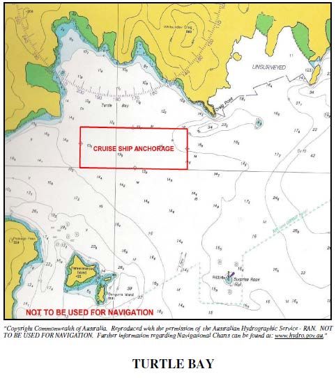
Table of Amendments
  Contact for enquiries and proposed changes. If you have any questions regarding this document or if
  you have a suggestion for improvements, please contact:

                        Contact officer: ............... Regional Harbour Master (Mackay)

                        Phone: ............................ +61 7 4944 3700

                        Fax: ................................. +61 7 4944 3790

                        Email: .............................. mackaymarine@msq.qld.gov.au

                         Page number or
Revision Date                                          Summary of Changes            Approved by
                         section

April 2009                -                             First Issue                   Regional Harbour Master

January 2016              -                             Second Issue                  Regional Harbour Master

September 2016            Various                       TOMSA / TOMSR updates         Regional Harbour Master

                                                        Corrected formatting for
November 2016             Various                       consistency. Updated          Regional Harbour Master
                                                        references to VTS Area
                          3.10, 4.10.4, 4.10.5,
October 2017                                            Amended                       Regional Harbour Master
                          4.10.7 & 6.1.1

May 2018                  Various                       Amended                       Regional Harbour Master

  Hard copies of this document are considered uncontrolled. Please refer to the Maritime Safety Queensland website for the
  latest version. Port Procedures and Information for Shipping – Whitsundays – May 2018                                      7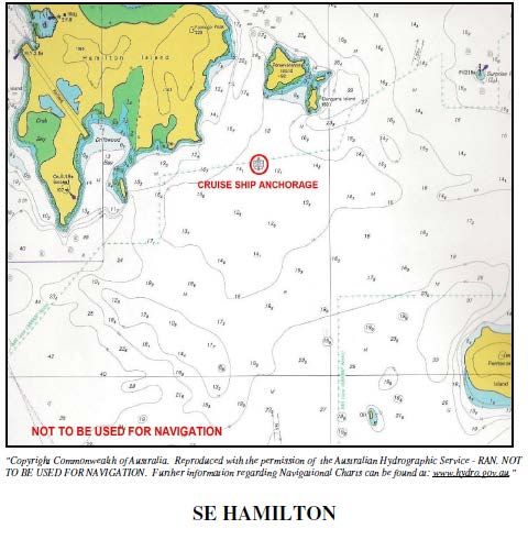
Section 1                  Introduction

              General
              The Whitsunday region is part of the Great Barrier Reef World Heritage Area and
              includes the commonwealth Great Barrier Reef Marine Park and Queensland national
              park and marine park areas.
              The area controlled encompasses the Whitsunday Passage, a number of cruise ship
              anchorages and numerous island passages, bays, beaches and inlets used by both
              recreational and commercial craft.
              Within the Whitsunday Islands are several holiday resorts some of which share
              boundaries with national parks under the direction of the National Parks and Wildlife
              Service (NPWS).
              Marine activity in the region is generally busy throughout the year but does experience
              periods of higher activity associated with annual holiday peaks. Regular ferry services
              interconnect the islands and the mainland and recreational boating is becoming
              increasingly popular as facilities are provided to cater for them.
              The Great Barrier Reef Marine Park Authority (GBRMPA) oversees designated zones in
              which all activities are controlled depending on the sensitivity of the particular zone.
              Some activities require the issue of a permit. For example cruise ship anchorages and
              certain areas are designated as preservation zones that prohibit all activities and are ‘no
              go’ areas. The marine park has ‘designated shipping areas’ (DSA) where particular
              activities, such as shipping, are permitted. Penalties apply for operating ships outside
              designated shipping areas without the written permission of the Great Barrier Reef
              Marine Park Authority.
              The Australian Maritime Safety Authority (AMSA), the Great Barrier Reef Marine Park
              Authority and Queensland authorities regularly monitor shipping activities to ensure that
              local, national and international laws are followed, and to record and evaluate shipping
              information for future policies. Ship owners, captains and crews face heavy fines and
              possible prosecution if they do not follow the rules and regulations of shipping within the
              Great Barrier Reef Marine Park.
              As a destination for domestic and international cruise shipping the Whitsunday region
              generally is highly attractive because of the its unique mix of environmental credentials,
              proximity to the Great Barrier Reef and quality tourist development.
              Cruise ship patronage of the Whitsunday region has expanded markedly in the last
              decade. Most of the international traffic favours the southern summer months, December
              to April, with cruise ships engaged mostly on Pacific-rim or round-world cruises. Domestic
              cruise ship traffic has tended to operate year-round.

              Purpose
              This document defines the standard procedures to be followed in the pilotage area; it
              contains information and guidelines to assist ship's masters, owners, and agents of
              vessels arriving at and traversing the area. It provides details of the services and the
              regulations and procedures to be observed.
              Nothing in this publication is intended to relieve any vessel, owner, operator, charterer,
              master, or person directing the movement of a vessel from the consequences of any
              failure to comply with any applicable law or regulation or of any neglect of precaution

Hard copies of this document are considered uncontrolled. Please refer to the Maritime Safety Queensland website for the
latest version. Port Procedures and Information for Shipping – Whitsundays – May 2018                                      8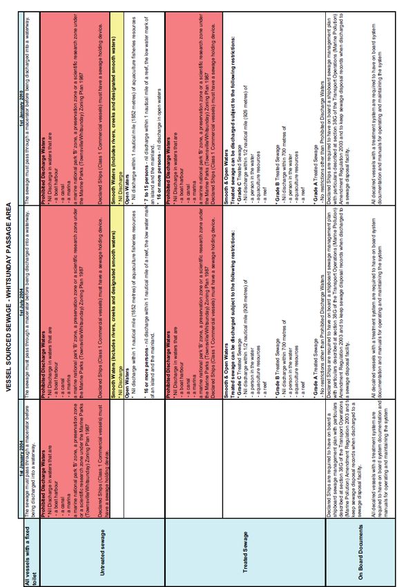
which may be required by the ordinary practice of seamanship, or by the special
              circumstances of the case.
              Information contained in this document is based on information available as at the latest
              date indicated on the document control sheet at the start of this publication. Although
              every care has been taken to ensure that this information is correct, no warranty,
              expressed or implied, is given in regard to the accuracy of all printed contents. The
              publisher shall not be responsible for any loss or damage resulting from or caused by any
              inaccuracy produced herein.

                   Information on external agencies (customs, quarantine, port authority rules, and
                      REEFREP and so on) is provided as an example only. Readers are strongly
                      recommended to consult their respective websites for current information.

              The latest version of this publication is available on the Maritime Safety Queensland
              website.
              Any significant updates to the content of these procedures will be promulgated on this
              site.
              Should errors or omissions in this publication be noted, it would be appreciated if advice
              of these could be forwarded to:
                           The Regional Harbour Master (Mackay)
                           PO Box 58, Mackay, Queensland 4740
                           Phone: +61 7 4944 3700
                           Email: mackaymarine@msq.qld.gov.au

              Datum
              All water depths refer to the ‘lowest astronomical tide’ height (LAT). All positions in this
              manual are in WGS84.
              All directions are referenced to True North.

              Authorities
              The Transport Operations (Marine Safety) Act 1994 (section 88) — ‘A harbour master
              may direct the master of a ship to navigate or otherwise operate the ship in a specified
              way.’
              Maritime Safety Queensland, through the authority of the harbour master, has jurisdiction
              over the safe movement of all shipping within the pilotage area.
              The Transport Operations (Marine Pollution) Act 1995 (section 68) — ‘Authorised officers
              have the following functions — a) to investigate discharges prohibited by this act, b) to
              monitor compliance with this act, c) to monitor transfer operations, d) to examine ships
              using coastal waters to minimise discharges, e) to take action to remove a pollutant
              discharged into coastal waters or to mitigate its effect on Queensland marine and coastal
              environment.’
              The Great Barrier Reef Marine Park Act 1975 is the primary act in respect of the Great
              Barrier Reef Marine Park. It includes provisions which:
              •     establish the Great Barrier Reef Marine Park

Hard copies of this document are considered uncontrolled. Please refer to the Maritime Safety Queensland website for the
latest version. Port Procedures and Information for Shipping – Whitsundays – May 2018                                      9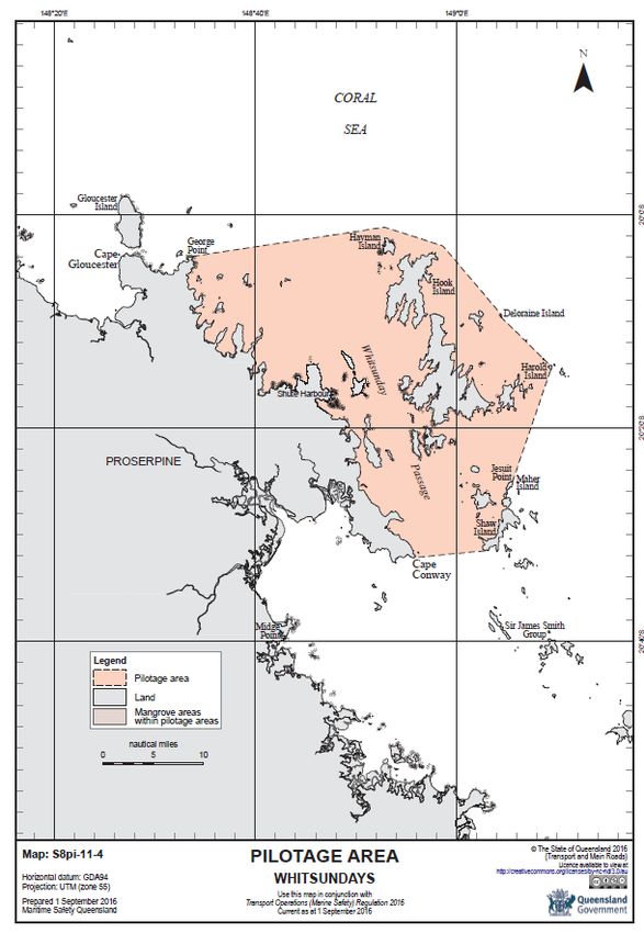
•    establish the Great Barrier Reef Marine Park Authority (GBRMPA), a commonwealth
                   authority responsible for the management of the marine park
              •    provide a framework for planning and management of the marine park, including
                   through zoning plans, plans of management and permits
              •    prohibit operations for the recovery of minerals (which includes prospecting or
                   exploration for minerals) in the marine park (unless approved by the Great Barrier
                   Reef Marine Park Authority for research)
              •    require compulsory pilotage for certain ships in prescribed areas of the Great Barrier
                   Reef Region
              •    provide for regulations, collection of environmental management charges,
                   enforcement and so on.
              The Environment Protection and Biodiversity Conservation Act 1999 (the EPBC act) is
              the Australian government's central piece of environmental legislation. It provides a legal
              framework to protect and manage nationally and internationally important flora, fauna,
              ecological communities and heritage places — defined in the act as matters of national
              environmental significance.

              Definitions
1.5.1         Australian Maritime Safety Authority (AMSA)
              The Australian Maritime Safety Authority is the commonwealth authority charged with
              enhancing efficiency in the delivery of safety and other services to the Australian maritime
              industry.

1.5.2         MASTREP — Modernised Australian Ship Tracking and Reporting System
              MASTREP is a Ship Reporting System designed to contribute to safety of life at sea and
              is operated by the Australian Maritime Safety Authority (AMSA) through the Rescue
              Coordination Centre (RCC) Australia in Canberra.

1.5.3         Great Barrier Reef Marine Park Authority (GBRPMA)
              A Commonwealth authority responsible for the management of the marine park within the
              Great Barrier Reef.

1.5.4         Highest astronomical tide (HAT)/Lowest astronomical tide (LAT)
              These are the highest and lowest levels that can be predicted to occur under average
              meteorological conditions and any combination of astronomical conditions. These levels
              may not be reached every year. HAT or LAT are not the extreme levels that can be
              reached, as storm surges can cause considerably higher or lower levels to occur.
              LAT is the datum to which all soundings are referred to.

1.5.5         International Maritime Organisation (IMO)
              The world organisation charged with enhancing efficiency in the delivery of safety to the
              whole maritime industry.

1.5.6         Maritime Safety Queensland (MSQ)
              The state government agency responsible for marine safety, the protection of the marine
              environment from ship-sourced pollution, Vessel Traffic Services and the administration

Hard copies of this document are considered uncontrolled. Please refer to the Maritime Safety Queensland website for the
latest version. Port Procedures and Information for Shipping – Whitsundays – May 2018                                    10
of all aspects of vessel registration and qualifications of mariners in the state of
Queensland.
1.5.7 Overall length (LOA)
The LOA is the extreme length of a vessel.
1.5.8 REEFREP
REEFREP is the mandatory ship reporting system established by IMO Resolution
MSC.52 (66), as amended by Resolution MSC.161 (78), and specified in Marine Orders
Part 63 (Reef VTS) Issue 2.
1.5.9 Reef VTS
The Great Barrier Reef and Torres Strait Vessel Traffic Service (Reef VTS) established
by Australia as a means of enhancing navigational safety and environmental protection in
Torres Strait and the Great Barrier Reef.
1.5.10 Regional Harbour Master (RHM)
The person authorised to give direction under the relevant provisions of the Transport
Operations (Marine Safety Act 1994).
1.5.11 Whitsundays Plan of Management (WPOM)
The Whitsundays Plan of Management (WPOM) was released by the Great Barrier Reef
Marine Park Authority to protect and conserve the values of the Whitsundays area.
Contact information
1.6.1 The Regional Harbour Master
For operational maritime questions, marine incidents, pollution, buoy moorings and
navigation aids, please contact the Regional Harbour Master's office located at:
Level 3, 44 Nelson Street, Mackay
Postal address:
PO Box 58, Mackay, Queensland 4740
Phone: ............................ +61 7 4944 3700,
Email: .............................. mackaymarine@msq.qld.gov.au
1.6.2 Great Barrier Reef Marine Park Authority
Sustainable Development and Policy Great Barrier Reef Marine Park Authority
2-68 Flinders Street (PO Box 1379), Townsville Queensland 4810
Phone: ............................ (07) 4750 0705
Fax: ................................. (07) 4750 0760
1.6.3 Hamilton Island Marina
Marina manager
Hard copies of this document are considered uncontrolled. Please refer to the Maritime Safety Queensland website for the
latest version. Port Procedures and Information for Shipping – Whitsundays – May 2018 11Phone: ............................ +61 7 4946 8352
Fax: ................................. +61 7 4946 8743
Mobile: ............................ +61 7 411 708 162
Email: .............................. marina@hamiltonisland.com.au
1.6.4 Reef VTS
Townsville Operations Centre
Phone: ............................ +61 7 4726 3428 / +61 1300 721 293
Fax: ................................. +61 7 4721 0633
Email: .............................. reefvts@vtm.qld.gov.au
VHF Channel: ................. 11, 14
1.6.5 Marine authorities
Organisation Telephone Facsimile Email
Hay Point VTS 07 4956 3489 07 4956 3367 VTSHayPoint@msq.qld.gov.au
Regional Harbour Master (Mackay) 07 4944 3700 07 4944 3790 mackaymarine@msq.qld.gov.au
Maritime Safety Queensland Airlie
07 4946 2200 07 4946 2233 mackaymarine@msq.qld.gov.au
Beach
Volunteer Marine Rescue 07 4946 7207 07 4946 5200 Whitsunday@vmraq.org.au
Water Police 07 4967 7222 07 4948 8855 waterpolice@police.qld.gov.au
Queensland Boating and Fisheries
07 4946 7003 07 4946 5186
Patrol
Great Barrier Reef Marine Park
1800 990 177 07 4772 6093 info@gbrmpa.gov.au
Authority
Queensland Parks and Wildlife
07 4967 7351
Service QPWS (Airlie Beach)
Department of Agriculture 0427 861 911
07 49559600 07 4955 9699
(Quarantine) or mackay@daff.gov.au
Australian Border Force 07 4965 7100 07 4965 7199 shipmac@customs.gov.au
Table 1 – Marine authorities
Hard copies of this document are considered uncontrolled. Please refer to the Maritime Safety Queensland website for the
latest version. Port Procedures and Information for Shipping – Whitsundays – May 2018 12Section 2 Whitsundays pilotage area
Pilotage area
This document applies to the designated pilotage area for the region as described in
Schedule 2 of the Transport Operations (Marine Safety) Regulation 2016 as the area of:
(a) waters bounded by an imaginary line drawn— starting at the high water mark at
the northern tip of George Point on the mainland:
• then to latitude 20º01.19' south, longitude 148º52.84' east
• then to latitude 20º02.94' south, longitude 148º58.63' east
• then to the high-water mark at the north-eastern tip of Deloraine Island
• then along the high-water mark of the eastern shoreline of Deloraine Island to
its south-eastern tip
• then to the high-water mark at the northern tip of Harold Island
• then along the high-water mark of the eastern shoreline of Harold Island to its
southern tip
• then to the high-water mark at the northern tip of Jesuit Point on Maher Island
• then along the high-water mark of the western shoreline of Maher Island to its
southern tip
• then to the high-water mark at the northern tip of Shaw Island
• then along the high-water mark of the western shoreline of Shaw Island to its
south-western tip
• then to the southern tip of Cape Conway on the mainland
• then by the high-water mark, initially in a general north-westerly direction, to
the starting point; and
(b) the navigable waters of rivers and creeks flowing, directly or indirectly, into the
waters in paragraph (a) (Whitsunday Pilotage area)
The Whitsunday pilotage area described above defines the area of jurisdictional control
for navigation purposes of Maritime Safety Queensland, with the local authority being the
Mackay Regional Harbour Master.
Compulsory pilotage area
The ‘compulsory pilotage area’ means all regulated ships must have a pilot on board
when travelling through the Inner Route, Hydrographer’s Passage and the Whitsundays.
This is defined under Regulation 118, Part 5 of the Great Barrier Reef Marine Park
Regulations 1983.
The compulsory pilotage area covering areas of the Whitsunday Passage, the
Whitsunday and the Lindeman Island groups is defined on AUS charts 824, 825 and 821.
Hard copies of this document are considered uncontrolled. Please refer to the Maritime Safety Queensland website for the
latest version. Port Procedures and Information for Shipping – Whitsundays – May 2018 13This pilotage area is bounded by a line that begins at the northernmost point of Cape
Gloucester at low water, at or about 20° 03·94’S, 148° 27·51’E, and continues
progressively:
(a) On geodesic lines to the following points:
1. 19o 58·02’S 148o 18·60’ E
2. 19o 57·83’S 148o 18·53’ E
3. 19o 58·00’S 148o 21·68’ E
4. 19o 58·28’S 148o27·05’ E
5. 19o 58·37’S 148o 27·40’ E
6. 19o 59·28’S 148o 33·62’ E
7. 20o 00·82’S 148o 37·48’ E
8. 20o 02·17’S 148o 53·07’ E
9. 20o 03·58’S 148o 57·92’ E
10. 20o 14·42’S 149o 10·47’ E
11. 20o 15·20’S 149o 11·15’ E
12. 20o 28·93’S 149o 08·03’ E
13. 20o 31·20’S 149o 09·07’ E
14. 20o 34·28’S 149o 10·50’ E
15. 20o 33·91’S 149o 07·06’ E
16. 20o 39·73’S 148o 45·82’ E
and
(b) West along the parallel 20° 39·73’S to the coastline of the mainland at low water,
near Midge Point; and
(c) Generally northerly, easterly, south-easterly and north-westerly along the
coastline of the mainland at low water to the point where the boundary began.
Applicable vessels
The following vessels that intend to transit between the Whitsunday’s region and the
mainland, within the GBRMPA designated compulsory pilotage area are required to carry
an AMSA licensed pilot:
• all vessels of 70 metres and over in length
• all loaded oil tankers, chemical carriers liquefied gas carriers and ships that come
within the INF code of any length
A preferred route is shown on charts AUS 824 and 825 to seaward of the compulsory
pilotage area. (Also refer section 3.2 for towed vessels in the compulsory area)
Pilotage services for cruise ships are provided by Australian Reef Pilots.
Bookings should be made directly with the service provider giving approximately five days
notice.
Hard copies of this document are considered uncontrolled. Please refer to the Maritime Safety Queensland website for the
latest version. Port Procedures and Information for Shipping – Whitsundays – May 2018 14Section 3 Movement and traffic procedures
General
Maritime Safety Queensland, through the authority of the RHM, has jurisdiction over the
safe movement of all shipping within the pilotage area.
The scheduling of ship movements is initiated by the agent submitting movement details
for a vessel to Hay Point VTS via the QSHIPS ship planning programme in accordance
with this section
These requirements apply to ships of 35 metres and over or a ship under 35 metres in
length that is combined with another ship for propelling one of the ships and the total
lengths of the ships is 35 metres or more proceeding to an anchorage within the pilotage
area of the Whitsundays. It does not apply to vessels transiting the pilotage area.
Applicable vessels (see section 2.2.2 above) are required to comply with the mandatory
reporting requirements of Reef VTS.
Vessel Traffic Service (VTS)
Maritime Safety Queensland does not operate a Vessel Traffic Service for the
Whitsunday pilotage area. However, a VTS centre operates from Hay Point, south of
Mackay with the callsign “Hay Point VTS” and maintains a listening watch on VHF
Channels 10, 16 and 67 via repeaters though the Whitsunday region.
Maritime Safety Queensland provides VTS in accordance with IMO Resolution A.857
(20). The role of the Hay Point VTS is to facilitate the safe and efficient movement of
large commercial shipping (passenger ships) within the pilotage area, including all
necessary coordination of port services, and dissemination of relevant information, to
ensure that a continual program of shipping movements can be affected to the advantage
of all commercial shipping in an impartial manner.
3.2.1 Information Service (INS)
The VTS or at the request of a vessel, can transmit essential and timely information to
assist in the on-board decision making process, which may include: position, identity and
intentions of other traffic, hazards and other factors which may affect a vessels transit.
3.2.2 Traffic Organisation Service (TOS)
The VTS will forward plan vessel movements to prevent congestion and provide for safe
and efficient movement of traffic. The VTS will identify and manage potentially dangerous
traffic situations and provide essential and timely information to assist the on-board
decision making process and may advise, instruct, or exercise the authority to direct
movements.
3.2.3 Navigational Assistance Service (NAS)
The VTS will, at the request of a Marine Pilot, provide navigational assistance for a deep
draft vessel, utilising the Departure Channel. The NAS provided will be limited to the
position of the vessel in relation to the departure channel centre line, utilising chainage of
offset format.
Hard copies of this document are considered uncontrolled. Please refer to the Maritime Safety Queensland website for the
latest version. Port Procedures and Information for Shipping – Whitsundays – May 2018 15Prior notification of movement
Action Minimum notice Approved form
Prior notification of arrival to an 48 hours prior to Arrival information to Regional Harbour Master via
anchorage in the pilotage area entry QSHIPS and Port Control.
Transport of dangerous goods 48 hours prior to Dangerous cargo report (section 7 Dangerous
in pilotage area entry Cargo)
At least three
Anchorage permit application
months prior to
to GBRMPA
arrival.
Fitzalan anchorage When application
Form 1 - Fitzalan Anchorage - Application for
‘Application for technical has been made for
technical assessment
assessment’ a GBRMPA permit
When application
Fitzalan anchorage ‘application
has been made for Form 2 - Fitzalan Anchorage - Application to visit
to visit’
a GBRMPA permit
Fitzalan anchorage ‘voyage At least three days
Form 3 - Fitzalan Anchorage - Voyage plan
plan’ prior to Arrival.
Table 2 – Prior notification of movement
3.3.1 QSHIPS (Queensland Shipping Information Planning System)
The movement of all vessels of LOA 35 m or more arriving at Whitsundays is recorded in
an internet based program known as QSHIPS. https://qships.tmr.qld.gov.au/webx/
The program is operated from the VTS centre; shipping agents submit booking
information on line in accordance with the reporting requirements and record their
requisitions for tugs, pilot and linesmen. The ancillary services respond on line to
acknowledge the booking and allocate their resources; the movement then assumes the
confirmed status. Work permits (section 10) requests should be submitted on line and to
the respective agencies if required. QSHIPS will indicate when the approval has been
granted and the agent is then able to print the permit for the vessel.
Since the program is live, port service providers, agents, government agencies and the
general community are able to view scheduled movements in any Queensland port in real
time.
Booking a vessel movement
When an agent is advised by his principals that a ship is bound for the Whitsundays then
that agent shall book in the ship via the QSHIPS program at least 48 hours prior to the
movement as required under Transport Operations (Marine Safety) Regulations 2016
section 168. Request for the supply of a pilot should also be made via
QSHIPS https://qships.tmr.qld.gov.au/webx
The use of the QSHIPS program is recommended for notification of the impending arrival
and subsequent movements of a vessel unless exceptional circumstances preclude this.
If an agent is unable to submit a booking by QSHIPS the Arrival / Departure Report must
be faxed or emailed to the VTS centre. If a vessel is calling at the port for the first time the
Vessel details report (new ship) form must also be completed and submitted.
Details of any removal movement and departure information are to be submitted at least
24 hours prior to the start time in a similar manner to the above.
Arrival advice should be confirmed to the VTS centre 24 hours prior to the start of the
movement.
Hard copies of this document are considered uncontrolled. Please refer to the Maritime Safety Queensland website for the
latest version. Port Procedures and Information for Shipping – Whitsundays – May 2018 16Arrival reporting requirements
Report the expected arrival date and time at the pilotage area to the Regional Harbour
Master by;
• If the ship is 50m or more in length, notifying Hay Point VTS by submitting a booking
in QSHIPS at least 48 hours prior to the expected arrival at the pilotage area.
• .If the ship is 35m or more in length, but less than 50m in length, notifying Hay Point
VTS at least 24 hours prior to the expected arrival at the pilotage area
When entering the pilotage area, notify Hay Point VTS, the ship’s name, intended
anchorage and ETA at the anchorage.
Notify Hay Point VTS when safely anchored.
Departure reporting requirements
Report the intended departure from the pilotage area to the Regional Harbour Master by;
• If the ship is 50m or more in length, notifying Hay Point VTS at least 24 hours prior to
departure.
• If the ship is 35m or more in length, but less than 50m in length, notifying Hay Point
VTS at the time of departure.
Notify Hay Point VTS when commence heaving anchor.
Notify Hay Point VTS when departing the pilotage area.
Tug and tow transiting the GBRMPA Compulsory pilotage
area.
The Regional Harbour Master has directed that ships engaged in towing or pushing;
• where the combined length of the tow measured from the stern of the towing vessel to
the stern of the last vessel being towed exceeds 150 metres
• and intend to transit between the Whitsunday’s region and the mainland, within the
GBRMPA designated compulsory pilotage area
are required to carry an AMSA licensed pilot. (Refer section 2.2.2 for more information)
Cruise ship anchorage applications
There are eight gazetted cruise ship anchorages within the Whitsundays that are
controlled by a joint permit arrangement involving the Great Barrier Reef Marine Park
Authority and Queensland Parks and Wildlife Service. The issue of a permit is required
for vessels over 70 metres LOA.
Vessels wishing to use these anchorages should make application to GBRMPA as
(www.gbrmpa.gov.au/zoning-permits-and-plans/permits) early as possible as the
application can take at least three months to process and is issued on a first come first
served basis. The permit is issued for a specific anchorage on a specified date. With the
exception of the Turtle Bay anchorage only one ship at a time is permitted to use a
designated anchorage.
Vessels planning to visit the Fitzalan anchorage are required to submit the following
forms to the Mackay Regional Harbour Master. These documents can be lodged by the
ship’s master, owner/operator, or the ship’s Australian port agent on their behalf:
Hard copies of this document are considered uncontrolled. Please refer to the Maritime Safety Queensland website for the
latest version. Port Procedures and Information for Shipping – Whitsundays – May 2018 17Form 1 - Fitzalan Anchorage - Application for technical assessment;
(9.2) this includes the technical details of the vessel — LOA, tonnage, draft, manoeuvring
and navigational equipment for assessment.
Form 2 - Fitzalan Anchorage - Application to visit;
(9.3) intended date of visit and planned times of arrival and departure.
Form 3 - Fitzalan Anchorage - Voyage plan
(9.4) at least three (3) days prior to arrival at the anchorage. A 9.9m shoal patch to the
south east of “Reef Pt” (approx. position Lat 21° 17.5’S, Long 148° 54.7’E is the
controlling depth for ships entry into Fitzalan Passage.
Dangerous goods must not be brought into or handled in the pilotage area until
notification has been sent to the harbour master in the approved Dangerous Cargo
Report form at least 48 hours prior to arrival in port limits. For further information (see
section 7)
MASTREP
The Modernised Australian Ship Tracking and Reporting System (MASTREP) as
described in Marine Order 63 (MASTREP) 2013, effective 1 July 2013, is used to track
the location of vessels. Under this system:
• Positional reporting for vessels is sourced from the vessel’s Automatic Identification
System (AIS).
• Sailing Plans, Deviation Reports and Final Reports are not required.
• Communications with vessels continue to be available through Inmarsat, HF,
satellite telephony and other means.
• Special Reports are required to support AMSA’s role in shipping oversight and
incident reporting management.
MASTREP is operated by the Australian Maritime Safety Authority (AMSA) as part of the
services offered by the Rescue Coordination Centre (RCC Australia). RCC Australia is
staffed 24 hours per day.
Reporting defects
The Australian Maritime Safety Authority (AMSA) requires notification of any deficiencies
or suspected deficiencies on ships visiting Australian ports. Deficiencies are to be
reported to AMSA which can be found on AMSA website.
‘Report of suspected non-compliance with Navigation Act or Safety/Pollution
conventions’.
Hard copies of this document are considered uncontrolled. Please refer to the Maritime Safety Queensland website for the
latest version. Port Procedures and Information for Shipping – Whitsundays – May 2018 18Section 4 Cruise ship anchorages
General
In order to meet the growing demand for anchorage sites for visiting cruise vessels eight
‘cruise ship anchorages’ have been designated within the ‘Whitsunday Planning Area’
that are controlled by a joint permitting arrangement involving the Great Barrier Reef
Marine Park Authority and Queensland Parks and Wildlife Service. Link to Whitsundays
Cruise ship anchorages.
Cruise ships are required to carry a licensed pilot in the Whitsunday compulsory pilotage
area. Anchorages are booked on a ‘first come, first served’ basis.
Pilotage
Great Barrier Reef Marine Park regulations introduced in October 2000 require all vessels
over 70 metres LOA to engage a licensed pilot when transiting the ‘Whitsunday Plan of
Management’ (WPOM) compulsory pilotage area.
Furthermore, cruise ships seeking a permit to enter any of the gazetted anchorages and
conduct tourist activities are obliged under the WPOM to engage a licensed pilot. The
region is within the jurisdictional limits of Queensland Barrier Reef pilots’ licenses issued
by the Australian Maritime Safety Authority.
Pilotage services for cruise ships in the Whitsundays are provided Australian Reef Pilots.
Preferably four to five days’ notice is required.
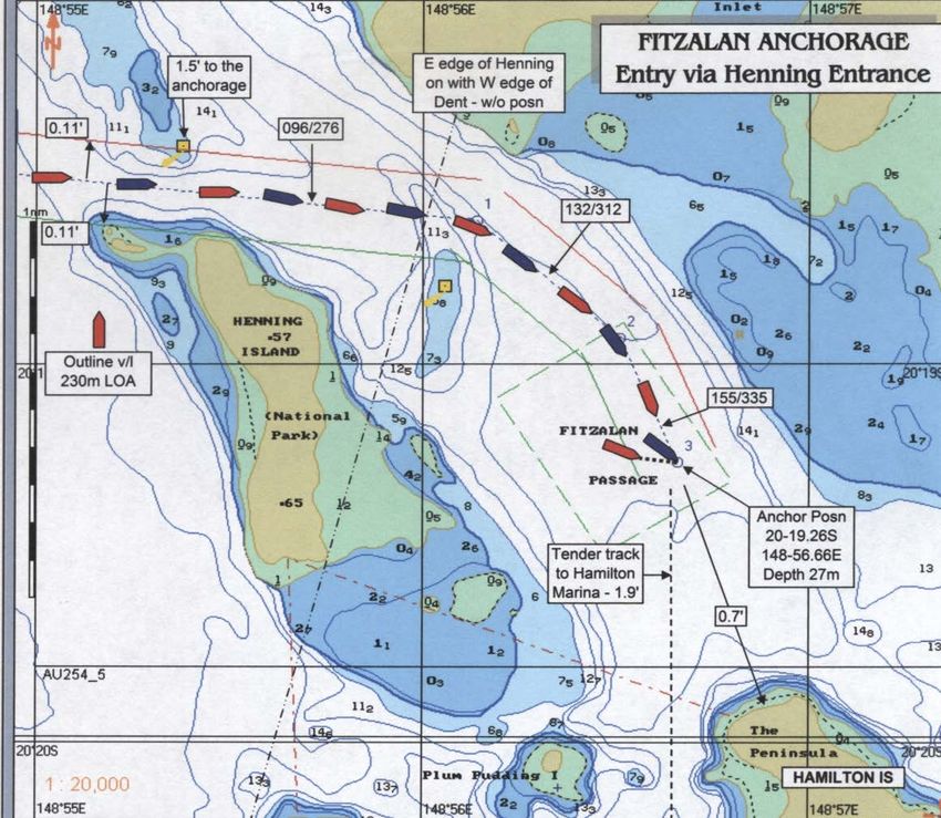
Fitzalan anchorage
The information on Fitzalan Anchorage is reproduced from a document written by Captain
J Ellyett — Regional Harbour Master (Mackay) and Captain John Foley (Australian Reef
Pilots Pty Ltd) in 2009. The material contained in this document contributes to the safe
and efficient management of shipping within Queensland waters. This does not absolve
the master of responsibility for all aspects of the safe navigation and operation of the
ship. This material is current at time of promulgation. Any detail shown in diagrammatic
form is not to be used for navigational purposes.)
Fitzalan Anchorage lies close north of Hamilton Island in Queensland’s Whitsunday
Islands region. It is bounded by Whitsunday Island to the north and east, Hamilton Island
to the south, and Henning Island to the west. First declared available for cruise ship traffic
in early 2003, it is one of eight gazetted Whitsunday cruise ship anchorages. In the
absence of any official name the area is referred to as Fitzalan Anchorage, the name
Fitzalan taken from a nearby channel between Fitzalan Island and Hamilton Island;
locally, the region is known as Hamilton Cove. Being almost landlocked, Fitzalan
Anchorage is in consequence protected from strong winds, ocean seas and swells.
The recommended anchorage position is approximately 1·8 miles from the landing
pontoon in Hamilton Island harbour. The harbour contains a marina with 135 berths, plus
public landing pontoons. Cruise ships anchored in Fitzalan Anchorage are entitled to use
their tenders to shuttle passengers to Hamilton Harbour.
Hamilton Island is described as a residential resort, with a range of accommodation
styles, private residences, specialty shops, restaurants, banks, and a variety of tourist
attractions on the island itself.
Hard copies of this document are considered uncontrolled. Please refer to the Maritime Safety Queensland website for the
latest version. Port Procedures and Information for Shipping – Whitsundays – May 2018 19You can also read