Port Procedures and Information for
Shipping - Ports of Cape Flattery,
Cooktown and Port Douglas

June 2020
←
→
Page content transcription
If your browser does not render page correctly, please read the page content below
Port Procedures and Information for Shipping - Ports of Cape Flattery, Cooktown and Port Douglas June 2020
Creative Commons information
                  © State of Queensland (Department of Transport and Main Roads) 2020

                  http://creativecommons.org.licences/by/4.0/
                  This work is licensed under a Creative Commons Attribution 4.0 Licence. You are free to
                  copy, communicate and adapt the work, as long as you attribute the authors.
                  The Queensland Government supports and encourages the dissemination and exchange of
                  information. However, copyright protects this publication. The State of Queensland has no
                  objection to this material being reproduced, made available online or electronically but only if
                  its recognised as the owner of the copyright and this material remains unaltered.
                              The Queensland Government is committed to providing accessible services to
                              Queenslanders of all cultural and linguistic backgrounds. If you have difficulty
                              understanding this publication and need a translator, please call the Translating and
                              Interpreting Service (TIS National) on 13 14 50 and ask them to telephone the Queensland
                              Department of Transport and Main Roads on 13 74 68.
                  Disclaimer: While every care has been taken in preparing this publication, the State of
                  Queensland accepts no responsibility for decisions or actions taken as a result of any data,
                  information, statement or advice, expressed or implied, contained within. To the best of our
                  knowledge, the content was correct at the time of publishing.

Hard copies of this document are considered uncontrolled. Please refer to the Maritime Safety Queensland website for the latest version.
Port Procedures and Information for Shipping – Ports of Cape Flattery, Cooktown and Port Douglas, June 2020.                          2
Harbour Master’s Direction
                                    Transport Operations (Marine Safety) Act 1994
                                      Division 2, Subdivision 1, Sections 88 – 92

         I, Captain David Ferguson, Regional Harbour Master, Cairns am appointed as harbour master under
         part 7 of Transport Operations (Marine Safety) Act 1994.

         Under section 86 of the Transport Operations (Marine Safety) Act 1994 a harbour master may give a
         direction only if the harbour master reasonably considers it necessary to ensure safety. Further, section
         86A of the Transport Operations (Marine Safety) Act 1994 enables a harbour master to give a general
         direction that applies to all ship owners, ship masters, ships, other persons or matters.

         I am satisfied that it is necessary to issue this direction to ensure marine safety in the Ports of Cape
         Flattery, Cooktown and Port Douglas. Sections of the Port Procedures and Information for Shipping –
         Ports of Cape Flattery, Cooktown and Port Douglas (https://www.msq.qld.gov.au/Shipping) are
         mandatory and must be complied with.

         I DIRECT THAT:
         The Port Procedures and Information for Shipping – Port of Cape Flattery, Cooktown and Port Douglas
         must be complied with by all vessels within the Port of Cape Flattery, Cooktown and Port Douglas.

         Note:
         It is an offence to fail to comply with my direction without reasonable excuse. It is also an offence
         to obstruct a harbour master in the exercise of a power. The maximum penalty is $20,000 for an
         individual for each offence. If you fail to comply with my direction, then I may carry out the
         direction myself, and recover all expenses associated with performing the direction from you as
         a debt in civil jurisdiction.

         Captain David Ferguson
         Regional Harbour Master – Cairns
         Maritime Safety Queensland
         DATED AT CAIRNS THIS 3rd Day of June 2020

Hard copies of this document are considered uncontrolled. Please refer to the Maritime Safety Queensland website for the latest version.
Port Procedures and Information for Shipping – Ports of Cape Flattery, Cooktown and Port Douglas, June 2020.                          3
Contents
         Contents                                                                                                     4

         List of Tables                                                                                               9

         Table of amendments                                                                                         10

         1.         Introduction                                                                                     12
         1.1        General                                                                                          12
         1.1.1      Cape Flattery                                                                                    12
         1.1.2      Cooktown                                                                                         12
         1.1.3      Port Douglas                                                                                     12
         1.1.4      Maritime Safety Queensland                                                                       12
         1.2        Purpose                                                                                          13
         1.3        Datum                                                                                            14
         1.4        Definitions                                                                                      14
         1.4.1      AMSA – Australian Maritime Safety Authority                                                      14
         1.4.2      Australian Standard – AS 3846 – 2005                                                             14
         1.4.3      GBRMPA – Great Barrier Reef Marine Park Authority                                                14
         1.4.4      LAT – lowest astronomical tide                                                                   14
         1.4.5      Manager (Pilotage Services)                                                                      14
         1.4.6      Manager (Vessel Traffic Management)                                                              14
         1.4.7      Maritime Safety Queensland (MSQ)                                                                 14
         1.4.8      MASTREP – the Modernised Australian Ship Tracking and Reporting System                           15
         1.4.9      Navigation Act                                                                                   15
         1.4.10     LOA – Length over all                                                                            15
         1.4.11     PEC – pilotage exemption certificate                                                             15
         1.4.12     FNQPC – Far North Queensland Ports Corporation Limited                                           15
         1.4.13     QSHIPS – Queensland Shipping Information Planning System                                         15
         1.4.14     REEFREP                                                                                          15
         1.4.15     Reef VTS                                                                                         15
         1.4.16     Regional Harbour Master (RHM)                                                                    15
         1.4.17     Sailing time                                                                                     15
         1.4.18     Vessel traffic service operator (VTSO)                                                           16
         1.4.19     Vessel traffic service (VTS)                                                                     16
         1.5        Contact information                                                                              16
         1.5.1      The Regional Harbour Master                                                                      16
         1.5.2      Port control                                                                                     16
         1.5.3      Port authority                                                                                   16
         1.6        Rules and regulations                                                                            16
         1.6.1      General                                                                                          16
         1.6.2      Applicable regulations                                                                           17
         1.6.3      Permits                                                                                          18

         2.         Arrival and departure procedures                                                                 19
         2.1        General                                                                                          19
         2.2        Arrival checklist -Cape Flattery, Cooktown and Port Douglas                                      19
         2.3        Departure checklist – Cape Flattery, Cooktown and Port Douglas                                   19

Hard copies of this document are considered uncontrolled. Please refer to the Maritime Safety Queensland website for the latest version.
Port Procedures and Information for Shipping – Ports of Cape Flattery, Cooktown and Port Douglas, June 2020.                          4
2.4        Quarantine                                                                                       20
         2.4.1      Ballast water information                                                                        20
         2.5        Customs                                                                                          20
         2.6        Dangerous goods                                                                                  20
         2.7        MASTREP Reporting                                                                                20
         2.8        Reef VTS                                                                                         21
         2.9        Security                                                                                         21

         3.         Movement notification and traffic procedures                                                     22
         3.1        General                                                                                          22
         3.1.1      Port control                                                                                     22
         3.1.2      Port Control role                                                                                22
         3.2        Harbour contact details                                                                          22
         3.3        Prior notification of movement                                                                   23
         3.4        QSHIPS (Queensland Shipping Information Planning System)                                         23
         3.5        Booking a vessel movement                                                                        23
         3.6        Passenger ship bookings – Cooktown and Port Douglas                                              24
         3.6.1      Passenger ship tender operations – Cooktown and Port Douglas                                     24
         3.7        Reporting defects                                                                                24
         3.8        Pilotage delays                                                                                  24
         3.9        Movement scheduling                                                                              25
         3.9.1      Schedule changes                                                                                 25
         3.10       Anchoring – Cape Flattery                                                                        25
         3.11       Master / pilot responsibilities                                                                  25

         4.         Port description                                                                                 26
         4.1        Pilotage area – Cape Flattery                                                                    26
         4.1.1      Pilotage area – Cooktown                                                                         26
         4.1.2      Pilotage area – Port Douglas                                                                     26
         4.2        Load lines                                                                                       26
         4.3        Maximum vessel size – Cape Flattery                                                              26
         4.3.1      Maximum vessel size – Cooktown                                                                   27
         4.3.2      Maximum vessel size – Port Douglas                                                               27
         4.4        Trim requirements                                                                                27
         4.5        Time zone                                                                                        27
         4.6        Charts and books                                                                                 27
         4.6.1      Cape Flattery                                                                                    27
         4.6.2      Cooktown                                                                                         27
         4.6.3      Port Douglas                                                                                     28
         4.6.4      Differential Global Positioning System (DGPS) Service                                            28

         5.         Port infrastructure                                                                              29
         5.1        Berth information – Cape Flattery                                                                29
         5.1.1      Main wharf                                                                                       29
         5.1.2      Service jetty                                                                                    29
         5.1.3      Leading lights and beacons                                                                       30
         5.1.4      Anchorage areas                                                                                  30
         5.2        Berth Information – Cooktown                                                                     30
         5.2.1      Channel Depths                                                                                   30
         5.2.2      Berthing and vessel facilities                                                                   30
         5.2.3      Beacons – entrance channel                                                                       30
         5.3        Berth Information – Port Douglas                                                                 31

Hard copies of this document are considered uncontrolled. Please refer to the Maritime Safety Queensland website for the latest version.
Port Procedures and Information for Shipping – Ports of Cape Flattery, Cooktown and Port Douglas, June 2020.                          5
5.3.1      Berth channel information                                                                        31
         5.3.2      Berthing and vessel facilities                                                                   31
         5.3.3      Leading lights and beacons                                                                       31
         5.3.4      Anchorages                                                                                       32

         6.         Weather information                                                                              33
         6.1        General                                                                                          33
         6.2        Extreme weather event contingency plan                                                           33
         6.3        Tidal information                                                                                34
         6.3.1      Tidal information – tsunami effects                                                              34

         7.         Port navigation and movement restrictions                                                        35
         7.1        General                                                                                          35
         7.2        Cautions – Cape Flattery                                                                         35
         7.3        Movement restrictions                                                                            35
         7.3.1      Under keel clearance                                                                             35
         7.3.2      Weather restrictions – Cape Flattery                                                             36
         7.3.3      Berthing direction – Cape Flattery                                                               36
         7.4        Approaches to the port – Cape Flattery                                                           36
         7.4.1      Dangers                                                                                          36
         7.5        Approaches to the port – Cooktown                                                                36
         7.5.1      Approaches from the south east                                                                   36
         7.5.2      Approaches from the south east                                                                   37
         7.6        Advisory Note – Interaction with Marine Mammals                                                  37

         8.         Pilotage                                                                                         38
         8.1        Vessels that require a pilot – Cape Flattery                                                     38
         8.1.1      Cooktown and Port Douglas                                                                        38
         8.1.2      Night pilotage – Cape Flattery                                                                   38
         8.1.3      Request for pilot                                                                                38
         8.1.4      Notice required – Cape Flattery                                                                  38
         8.1.5      Personal Pilot Unit (PPU)                                                                        38
         8.2        Pilotage area                                                                                    38
         8.2.1      Pilot boarding position – Cape Flattery                                                          38
         8.2.2      Passage planning –Bridge Resource Management (BRM)                                               39
         8.2.3      Alcohol consumption                                                                              39
         8.2.4      Pilotage reporting requirements for Torres Strait and Great Barrier Reef (GBR)                   39

         9.         Tugs                                                                                             41
         9.1        Tug information                                                                                  41
         9.1.1      Berthing and unberthing – Cape Flattery                                                          41

         10.        Work permits                                                                                     42
         10.1.1     Miscellaneous permits                                                                            43
         10.1.2     Diving operations                                                                                43
         10.2       Work permits                                                                                     43
         10.2.1     Immobilisation main engines                                                                      43
         10.2.2     Hot work permit                                                                                  43
         10.2.3     Boat drills                                                                                      44
         10.2.4     Engine trials                                                                                    44
         10.2.5     Notification of handling of bulk liquids/Night Fuel Transfers                                    44
         10.2.6     Gas-free status                                                                                  44

Hard copies of this document are considered uncontrolled. Please refer to the Maritime Safety Queensland website for the latest version.
Port Procedures and Information for Shipping – Ports of Cape Flattery, Cooktown and Port Douglas, June 2020.                          6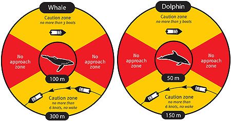
10.2.7     Overside maintenance work                                                                        45

         11.        Dangerous cargo                                                                                  46
         11.1       General                                                                                          46
         11.1.1     Notification                                                                                     46
         11.1.2     Dangerous cargo events                                                                           46

         12.        Emergency, pollution, marine incidents                                                           48
         12.1       Emergency contact numbers                                                                        48
         12.2       Authorities                                                                                      48
         12.3       Fire                                                                                             48
         12.3.1     Wharf / marina evacuation plan                                                                   49
         12.3.2     Emergency plans                                                                                  49
         12.4       Marine pollution                                                                                 49
         12.4.1     Reporting                                                                                        49
         12.5       Marine incidents                                                                                 50
         12.5.1     Procedures subsequent to serious marine incidents                                                50
         12.5.2     Marine incident reporting – Maritime Safety Queensland                                           50
         12.5.3     Marine incident reporting – the Australian Maritime Safety Authority                             51
         12.5.4     GBRMPA incident report form                                                                      51
         12.5.5     Environmental incident reporting                                                                 51
         12.6       Port community responsibilities                                                                  52

         13.        Security                                                                                         53
         13.1       General                                                                                          53
         13.1.1     Security levels                                                                                  53
         13.1.2     Maritime Security Zones – Cooktown and Port Douglas                                              53
         13.1.3     Security measures – Cape Flattery                                                                54
         13.1.4     Port security contacts – Cape Flattery                                                           54
         13.1.5     Reporting of incidents                                                                           54
         13.1.6     Refuse ship entry – no International Ship Security Certificate                                   54
         13.1.7     Shore access to ships and port facilities – Cooktown                                             55
         13.1.8     Port security contacts – Cooktown                                                                55
         13.2       National security                                                                                55

         14.        Port state control inspections                                                                   56

         15.        Port services                                                                                    57
         15.1       Cape Flattery                                                                                    57
         15.1.1     Bunkering                                                                                        57
         15.1.2     Fresh water                                                                                      57
         15.1.3     Waste                                                                                            57
         15.1.4     Shipping agencies                                                                                57
         15.2       Cooktown and Port Douglas                                                                        57
         15.2.1     Bunkering                                                                                        57
         15.2.2     Fresh water                                                                                      57
         15.2.3     Waste                                                                                            57
         15.2.4     Waste – quarantine                                                                               57
         15.2.5     Ship-sourced sewage                                                                              57
         15.2.6     Electric power                                                                                   58
         15.2.7     Miscellaneous contacts                                                                           58
         15.2.8     Shipping agencies                                                                                58

Hard copies of this document are considered uncontrolled. Please refer to the Maritime Safety Queensland website for the latest version.
Port Procedures and Information for Shipping – Ports of Cape Flattery, Cooktown and Port Douglas, June 2020.                          7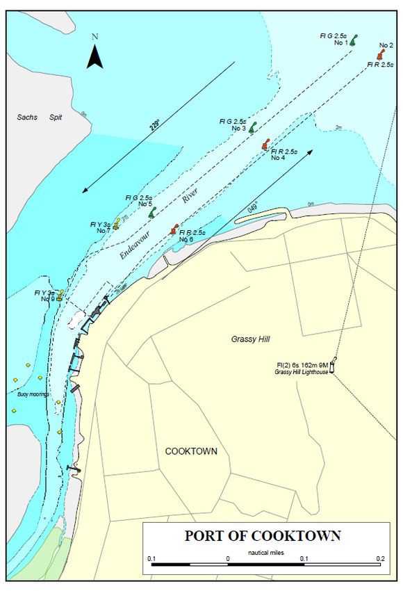
16.        Appendices                                                                                       60
         16.1       Port of Cape Flattery                                                                            61
         16.2       Pilotage plan – Cape Flattery                                                                    62
         16.3       Final approach and anchor drop position – Cape Flattery                                          63
         16.4       Moorings – Cape Flattery                                                                         64
         16.5       Port of Cooktown                                                                                 65
         16.6       Cooktown pilotage area                                                                           66
         16.7       Pilotage plan - Cooktown                                                                         67
         16.8       Port of Port Douglas                                                                             68
         16.9       Port Douglas pilotage area                                                                       69
         16.10      Pilotage plan – Port Douglas                                                                     70
         16.11      Bunker/Vessel Fuelling Notice FP001-4M                                                           71

Hard copies of this document are considered uncontrolled. Please refer to the Maritime Safety Queensland website for the latest version.
Port Procedures and Information for Shipping – Ports of Cape Flattery, Cooktown and Port Douglas, June 2020.                          8
List of Tables
         Table 1 – Arrival checklist                                                                                 19
         Table 2 – Departure checklist                                                                               19
         Table 3 – Harbour telephone contact details                                                                 23
         Table 4 – Pre-entry notification times                                                                      23
         Table 5 – Leading lights and beacons                                                                        30
         Table 6 – Channel Depths - Cooktown                                                                         30
         Table 7 – Navigational Aids- Cooktown                                                                       31
         Table 8 – Berth / Channel – Port Douglas                                                                    31
         Table 9 – Navigational Aids – Port Douglas                                                                  32
         Table 10 – Tide tables                                                                                      34
         Table 11 – Permit requests                                                                                  42
         Table 12 – Minimum movement notification                                                                    46
         Table 13 – Emergency contact numbers                                                                        48
         Table 14 – Shipping agencies                                                                                57
         Table 15– Miscellaneous contacts                                                                            58
         Table 16 – Shipping Agencies                                                                                59

Hard copies of this document are considered uncontrolled. Please refer to the Maritime Safety Queensland website for the latest version.
Port Procedures and Information for Shipping – Ports of Cape Flattery, Cooktown and Port Douglas, June 2020.                          9
Table of amendments
          Contact for enquiries and proposed changes. If you have any questions regarding this document or if
          you have a suggestion for improvements, please contact:
                  Contact officer:                           Regional Harbour Master, Cairns
                  Phone:                                     +61 7 4052 7470
                  Fax:                                       +61 7 4052 7460

            Revision Date         Page number       Summary of Changes                          Approved by
                                  or section
             September 2015        -                 First Issue – Combining Ports of Cape       Regional Harbour Master
                                                     Flattery, Cooktown and Port Douglas
             May 2016              1.1.4             Format correction                           Regional Harbour Master

             May 2016              1.5.2             Port Control Reference                      Regional Harbour Master

             May 2016              2.2               Format correction                           Regional Harbour Master
             May 2016              2.4               Information updated
             May 2016              2.8.1             AUSREP removed                              Regional Harbour Master
             May 2016              3.1.1             Title amended                               Regional Harbour Master
             May 2016              3.1.2             Port Control information                    Regional Harbour Master
             May 2016              3.2               Information updated                         Regional Harbour Master
             May 2016              3.8               Pilotage delay updated                      Regional Harbour Master
             May 2016              4.1               Format correction                           Regional Harbour Master
             May 2016              5.3.3             Duplicate removed                           Regional Harbour Master
             May 2016              10.1              Table amended                               Regional Harbour Master
             May 2016              10.2.3            Information amended                         Regional Harbour Master
             May 2016              10.2.5            Night fuel transfer updated                 Regional Harbour Master
             May 2016              12.3              Information amended                         Regional Harbour Master
             May 2016              12.5.3            DCV added                                   Regional Harbour Master
             May 2016              12.5.5            Information amended                         Regional Harbour Master
             May 2016              16.1              Form removed                                Regional Harbour Master
             June 2016             All               Updated to new TMR format                   Regional Harbour Master
             September 2016       Various            Update of TMOSA/TOMSR                       Regional Harbour Master
             February 2017        7.2                Gangway addition                            Regional Harbour Master
             June 2017            2.5                Updated Customs document                    Principal Manager –
                                                     timeframes                                  Vessel Traffic
                                                                                                 Management
             June 2017            1.1.1              Information Updated                         Regional Harbour Master
             June 2017            1.2                Email added                                 Regional Harbour Master
             June 2017            2.4.1              Link updated                                Regional Harbour Master
             June 2017            3.10               text corrected                              Regional Harbour Master
             June 2017            5.2.1              Information updated                         Regional Harbour Master
             June 2017            5.3.2              Information updated                         Regional Harbour Master
             June2017             14                 Link updated                                Regional Harbour Master
             August 2017          2.7 & 2.8          Information update                          Regional Harbour Master

Hard copies of this document are considered uncontrolled. Please refer to the Maritime Safety Queensland website for the latest version.
Port Procedures and Information for Shipping – Ports of Cape Flattery, Cooktown and Port Douglas, June 2020.                         10
August 2017 2.8.1 Section removed Regional Harbour Master
July 2018 3.10 Information updated Regional Harbour Master
July 2018 5.1.3 Information updated Regional Harbour Master
July 2018 5.2.3 Information updated Regional Harbour Master
July 2018 5.3.2 Information updated Regional Harbour Master
July 2018 5.3.3 Information updated Regional Harbour Master
July 2018 12.3 Information updated Regional Harbour Master
July 2018 15.2.8 Information updated Regional Harbour Master
September 2018 12.4, 12.4.1 Information updated Regional Harbour Master
April 2019 8.1.5 Information added Regional Harbour Master
May 2019 16.1, 16.2, Information updated Regional Harbour Master
16.3 and 16.4
May 2019 3.1.1 Section removed Regional Harbour Master
October 2019 5.2.1 Information updated Regional Harbour Master
February 2020 6.1 Information updated Regional Harbour Master
June 2020 RHM Direction Information updated Regional Harbour Master
Hard copies of this document are considered uncontrolled. Please refer to the Maritime Safety Queensland website for the latest version.
Port Procedures and Information for Shipping – Ports of Cape Flattery, Cooktown and Port Douglas, June 2020. 111. Introduction
1.1 General
1.1.1 Cape Flattery
Cape Flattery (14° 59’S, 145° 21·08’E) is situated 29 miles north of Cooktown. The port
has been established solely for the export of silica sand from Cape Flattery Silica Mines
Pty Ltd, a wholly owned subsidiary of the Mitsubishi Corporation. The mine is the largest
exporter of silica sand in the world, 2.4 million tonnes being exported in 2015/2016.
The port has a single berth serviced by a travelling ship loader for the export of sand; all
vessels berth starboard side to.
Cape Flattery is a compulsory pilotage area.
1.1.2 Cooktown
Cooktown is situated about 91 nautical miles north of Cairns and is the most northerly
port on the east coast of Australia. Today it is known as a community port, managed by
the Far North Queensland Ports Corporation (FNQPCL) and is used mainly by fishing
vessels, small passenger vessels and recreational craft. It provides a safe anchorage
inside the harbour although it is often crowded with vessels
Cooktown is not a compulsory pilotage area.
1.1.3 Port Douglas
Port Douglas is situated about 30 nautical miles north of Cairns and is a community port
within the jurisdiction of the Regional Harbour Master (Cairns). The port is used mainly by
tourist vessels visiting the islands and reef, fishing vessels and recreational craft. It is a
small natural harbour behind Island Point within the confines of Dickson Inlet. Port
Douglas has a number of small fishing wharves, two marinas and provides safe refuge for
anchored or moored vessels upstream.
Port Douglas is not a compulsory pilotage area.
Shipping legislation in Queensland is controlled by Maritime Safety Queensland (MSQ), a
branch of the Department of Transport and Main Roads.
1.1.4 Maritime Safety Queensland
The state of Queensland is divided up into six regions, five of which are controlled by a
Regional Harbour Master and the sixth by a manager, all officers of Maritime Safety
Queensland who report to the general manager and under the Transport Operations
(Marine Safety) Act 1994, are responsible for:
• improving maritime safety for shipping and small craft through regulation and
education
• minimising vessel sourced waste and providing response to marine pollution
• providing essential maritime services such as port pilots and aids to navigation
• encouraging and supporting innovation in the maritime industry.
Hard copies of this document are considered uncontrolled. Please refer to the Maritime Safety Queensland website for the latest version.
Port Procedures and Information for Shipping – Ports of Cape Flattery, Cooktown and Port Douglas, June 2020. 12The limit of Queensland coastal waters is defined by a line three nautical miles seaward
of the territorial sea baseline. The arrangements outlined in these procedures apply to the
geographical areas gazetted as pilotage areas in Queensland. Pilotage areas have been
gazetted around designated ports and maritime areas to ensure the safe and efficient
movement of shipping. These areas encompass the approaches, main shipping channel
and waters of the port.
Collectively, the Regional Harbour Master and the port authority have responsibility for
managing the safe and efficient operation of the port.
The Great Barrier Reef Marine Park Authority (GBRMPA) oversees designated zones in
which all activities are controlled depending on the sensitivity of the particular zone.
Some activities require the issue of a permit for example, cruise ship anchorages and
certain areas are designated as preservation zones that prohibit all activities and are ‘no
go’ areas. The marine park has designated shipping areas (DSA) where particular
activities, such as shipping, are permitted. Penalties apply for operating ships outside
designated shipping areas without the written permission of the Great Barrier Reef
Marine Park Authority.
The Australian Maritime Safety Authority, Great Barrier Reef Marine Park Authority and
Queensland authorities regularly monitor shipping activities to ensure that local, national
and international laws are followed, and to record and evaluate shipping information for
future policies. Ship owners, captains and crews face heavy fines and possible
prosecution if they do not follow the rules and regulations of shipping within the Great
Barrier Reef Marine Park.
The ports of Cape Flattery, Cooktown and Port Douglas are under the jurisdiction of the
Regional Harbour Master (Cairns).
MARITIME SAFETY QUEENSLAND ADVISES THAT ESTUARINE
CROCODILES ARE PRESENT IN THE WATERS OF THE PORT
1.2 Purpose
This document defines the standard procedures to be followed in the pilotage area of the
port. It contains information and guidelines to assist ship's masters, owners, and agents
of vessels arriving at and traversing the area. It provides details of the services and the
regulations and procedures to be observed.
Nothing in this publication is intended to relieve any vessel, owner, operator, charterer,
master, or person directing the movement of a vessel from the consequences of any
failure to comply with any applicable law or regulation or of any neglect of precaution
which may be required by the ordinary practice of seamanship, or by the special
circumstances of the case.
Information contained in this publication is based on information available as at the latest
date indicated on the document control sheet. Although every care has been taken to
ensure that this information is correct, no warranty, expressed or implied, is given in
regard to the accuracy of all printed contents. The publisher shall not be responsible for
any loss or damage resulting from or caused by any inaccuracy produced herein.
Information on external agencies (Customs, Quarantine, Port Authority Rules, REEFREP
and so on) is provided as an example only. Readers are strongly recommended to
consult their respective websites for current information.
The latest version of this publication is available on the Maritime Safety Queensland
website.
Any significant updates to the content of these procedures will be promulgated on this
website. The Far North Queensland Ports Corporation Limited website should be
consulted for the latest information on port rules in Cooktown.
Hard copies of this document are considered uncontrolled. Please refer to the Maritime Safety Queensland website for the latest version.
Port Procedures and Information for Shipping – Ports of Cape Flattery, Cooktown and Port Douglas, June 2020. 13Should errors or omissions in this publication be noted, it would be appreciated if advice
of these could be forwarded to:
The Regional Harbour Master (Cairns)
Maritime Safety Queensland
Postal address: GPO Box 1787, Cairns, Queensland, 4870
Email: vtscairns@msq.qld.gov.au
Phone: +61 7 4052 7470
Fax: +61 7 4052 7460
1.3 Datum
All water depths refer to the lowest astronomical tide height (LAT).
All positions in this manual are in WGS84.
All directions are referenced to true north.
1.4 Definitions
1.4.1 AMSA – Australian Maritime Safety Authority
The Australian Maritime Safety Authority is the Commonwealth authority charged with
enhancing efficiency in the delivery of safety and other services to the Australian maritime
Industry.
1.4.2 Australian Standard – AS 3846 – 2005
AS 3846 refers to the Australian requirements for the transport and handling of
dangerous goods in port areas.
1.4.3 GBRMPA – Great Barrier Reef Marine Park Authority
Commonwealth authority responsible for the management of the marine park.
1.4.4 LAT – lowest astronomical tide
This is the zero value from which all tides are measured.
1.4.5 Manager (Pilotage Services)
The person responsible for the service delivery of pilotage services within the region.
1.4.6 Manager (Vessel Traffic Management)
The person responsible for the management of the VTS centre.
1.4.7 Maritime Safety Queensland (MSQ)
The State government branch responsible for the operations of pilotage, pollution
protection services, vessel traffic services and the administration of all aspects of vessel
registration and marine safety in the state of Queensland.
Hard copies of this document are considered uncontrolled. Please refer to the Maritime Safety Queensland website for the latest version.
Port Procedures and Information for Shipping – Ports of Cape Flattery, Cooktown and Port Douglas, June 2020. 141.4.8 MASTREP – the Modernised Australian Ship Tracking and
Reporting System
The Modernised Australian Ship Tracking and Reporting System (MASTREP) is a Ship
Reporting System designed to contribute to safety of life at sea and is operated by the
Australian Maritime Safety Authority (AMSA) through the Rescue Coordination Centre
(RCC) Australia in Canberra.
1.4.9 Navigation Act
Refer to the Navigation Act 2012
1.4.10 LOA – Length over all
Extreme length of the vessel.
1.4.11 PEC – pilotage exemption certificate
Exemption granted to certain qualified masters who have satisfied the necessary
legislative requirements and are authorised to navigate ships in the port pilotage area
without a pilot.
1.4.12 FNQPC – Far North Queensland Ports Corporation Limited
Far North Queensland Ports Corporation Limited (FNQPC) is charged with overseeing
the commercial activities in the port, including the maintenance of the port infrastructure.
1.4.13 QSHIPS – Queensland Shipping Information Planning
System
An internet web based ship movement booking service that may be accessed by the
shipping community 24 hours a day seven days a week.
The program allows port service provider organisations the ability to accept service
requests made by shipping agents and streamline ship movement planning by
significantly reducing the existing levels of point to point communications that are
necessary to ensure a planned ship movement has been adequately resourced with
supporting services.
1.4.14 REEFREP
The mandatory ship reporting system established by IMO Resolution MSC.52 (66), as
amended by Resolution MSC.161 (78), and specified in Marine Orders 63 (Vessel
reporting systems) 2015.
1.4.15 Reef VTS
The Great Barrier Reef and Torres Strait Vessel Traffic Service (Reef VTS) established
by Australia as a means of enhancing navigational safety and environmental protection in
Torres Strait and the Great Barrier Reef.
1.4.16 Regional Harbour Master (RHM)
The person authorised to give direction under the relevant provisions of the Transport
Operations (Marine Safety) Act 1994.
1.4.17 Sailing time
The actual sailing time is the time of the last line.
Hard copies of this document are considered uncontrolled. Please refer to the Maritime Safety Queensland website for the latest version.
Port Procedures and Information for Shipping – Ports of Cape Flattery, Cooktown and Port Douglas, June 2020. 151.4.18 Vessel traffic service operator (VTSO)
A person, suitably qualified, delegated by the Regional Harbour Master to monitor the
safe movement of vessels and to give direction under the relevant provisions of the
Transport Operations (Marine Safety) Act 1994.
1.4.19 Vessel traffic service (VTS)
VTS is any service implemented by a competent authority, designed to maximise the safe
and efficient movement of water borne traffic.
1.5 Contact information
1.5.1 The Regional Harbour Master
For operational maritime questions, marine incidents, pollution, pilotage, buoy moorings
and navigation aids please contact the harbour master's office. The harbour master's
office is located at:
Physical address: 100-106 Tingira Street, Portsmith, Queensland 4870
Postal address: GPO Box 1787, Cairns, Queensland 4870
Phone: +61 7 4052 7412
Fax: +61 7 4052 7451
Email: rhmcairns@msq.qld.gov.au
1.5.2 Port control
A Port Control Service operates for scheduled shipping in Cape Flattery and is operated
from the Cairns VTS Centre under the callsign,’Cape Flattery Port Control’ on VHF13.
There is no vessel traffic service operated for the ports for Cooktown or Port Douglas. For
ship traffic scheduling, pollution incidents and reporting defective navigation aids please
direct initial enquiries by phone, email or fax to the VTS Centre at Cairns.
Phone: +61 7 4052 7470
Fax: +61 7 4052 7460
Email: vtscairns@msq.qld.gov.au
Ship traffic movements may be accessed on the QSHIPS website.
1.5.3 Port authority
The primary function of Ports Far North Queensland Ports Corporation Limited (FNQPC)
trading as Far North Queensland Ports Corporation Limited, under the Transport
Infrastructure Act 1994, is to establish, manage and operate effective and efficient
facilities and services within the port, while maintaining appropriate levels of safety and
security.
They have no direct representation in Cape Flattery and Cooktown; all enquiries should
be directed to the office in Cairns.
Phone: Duty Officer (24 hours) +61 7 4051 2558
1.6 Rules and regulations
1.6.1 General
The rules and regulations in the port contribute to the safe, efficient and environmentally
responsible handling of shipping traffic.
Hard copies of this document are considered uncontrolled. Please refer to the Maritime Safety Queensland website for the latest version.
Port Procedures and Information for Shipping – Ports of Cape Flattery, Cooktown and Port Douglas, June 2020. 16The international rules of the IMO, such as the SOLAS convention and its amendments
(for example the IMDG code) and state, national and local port authority regulations are
in force in the port.
Based on the Cape Flattery, and Cooktown port notices, the port rules on dangerous
substances contain additional, specific regulations for ships carrying dangerous cargoes
in the port.
1.6.2 Applicable regulations
The Transport Operations (Marine Safety) Act 1994 (Section 88) – “A harbour master
may direct the master of a ship to navigate or otherwise operate the ship in a specified
way.”
Maritime Safety Queensland, through the authority of the Regional Harbour Master, has
jurisdiction over the safe movement of all shipping within the pilotage area.
The Transport Operations (Marine Pollution) Act 1995 Section 68 – “Authorised officers
have the following functions: a) to investigate discharges prohibited by this Act, b) to
monitor compliance with this Act, c) to monitor transfer operations, d) to examine ships
using coastal waters to minimise discharges, e) to take action to remove a pollutant
discharged into coastal waters or to mitigate its effect on Queensland marine and coastal
environment.”
The Great Barrier Reef Marine Park Act 1975 is the primary act in respect of the Great
Barrier Reef Marine Park. It includes provisions which:
• establish the Great Barrier Reef Marine Park
• establish the Great Barrier Reef Marine Park Authority (GBRMPA), a
Commonwealth authority responsible for the management of the marine park
• provide a framework for planning and management of the marine park, including
through zoning plans, plans of management and permits
• prohibit operations for the recovery of minerals (which includes prospecting or
exploration for minerals) in the marine park (unless approved by the GBRMPA for
research)
• require compulsory pilotage for certain ships in prescribed areas of the Great
Barrier Reef region
• provide for regulations, collection of environmental management charge,
enforcement and so on.
• The Environment Protection and Biodiversity Conservation Act 1999 (the EPBC
Act) is the Australian Government's central piece of environmental legislation. It
provides a legal framework to protect and manage nationally and internationally
important flora, fauna, ecological communities and heritage places – defined in
the act as matters of national environmental significance.
In addition, they will also complement the procedures of:
• Far North Queensland Ports Corporation Limited (FNQPC)
• Cook Shire Council
• Port Douglas Council
• Australian Maritime Safety Authority
• Quarantine - Department of Agriculture
• Customs - Australian Broder Force
• Royal Australian Navy (RAN)
as they relate to ship movements within the jurisdiction of the Regional Harbour Master
(Cairns).
Hard copies of this document are considered uncontrolled. Please refer to the Maritime Safety Queensland website for the latest version.
Port Procedures and Information for Shipping – Ports of Cape Flattery, Cooktown and Port Douglas, June 2020. 171.6.3 Permits
Permission is required for special activities such as repairs hull cleaning and painting,
and so on. For further information, please refer to Section 10 Work Permits
Contact the Regional Harbour Master’s office via the QSHIPS website to make
application.
Hard copies of this document are considered uncontrolled. Please refer to the Maritime Safety Queensland website for the latest version.
Port Procedures and Information for Shipping – Ports of Cape Flattery, Cooktown and Port Douglas, June 2020. 182. Arrival and departure procedures
2.1 General
For a quick reference of what and when to report please consult the under mentioned
tables.
Masters of vessels arriving at, staying in or departing from the port are obliged to make
previous notification on a variety of subjects, ranging from health and immigration to
dangerous goods.
This section lists all the requirements for notifying the port authorities.
2.2 Arrival checklist -Cape Flattery, Cooktown
and Port Douglas
Sequence Time Report
Arrival information to Regional Harbour
1 48 hours before arrival
Master via QSHIPS.
Dangerous goods report to Regional
Harbour Master and Far North
2 48 hours before arrival
Queensland Ports Corporation Limited
(see 11 Dangerous cargo).
Customs (see 2.5 –Customs
3 96 hours before arrival
Customs - Australian Border Force
Quarantine (see 2.3– Table 2 –
Not more than 96 hours or less than Departure checklist
4
12 hours before arrival
Quarantine)
24 and 12 hours before arrival
Arrival information update to Regional
5 update estimated time of arrival if
Harbour Master via QSHIPS.
necessary
30 minutes before pilot boarding
time Call ‘Cape Flattery pilots’ on VHF
6
channel 16
Cape Flattery only
Table 1 – Arrival checklist
2.3 Departure checklist – Cape Flattery,
Cooktown and Port Douglas
Sequence Time Report
Confirm departure information to
1 24 hours before departure
Regional Harbour Master via QSHIPS.
Dangerous goods report to Regional
Harbour Master and Far North
2 Three hours before departure
Queensland Ports Corporation Limited
(see 11Dangerous cargo).
Pre-entry report to Reef VTS (see – 2.7
3 Two hours before departure
MASTREP Reporting and 2.8 Reef VTS
Table 2 – Departure checklist
Hard copies of this document are considered uncontrolled. Please refer to the Maritime Safety Queensland website for the latest version.
Port Procedures and Information for Shipping – Ports of Cape Flattery, Cooktown and Port Douglas, June 2020. 192.4 Quarantine
Source: Department of Agriculture,
The Department of Agriculture requires vessels from overseas to submit their
documentation no more than 96 hours and no less than 12 hours prior to arrival:
Contact details:
Phone: +61 7 4030 7800
Fax: +61 7 4241 784361 07 4035 9578
Email: via general enquiries on website
Postal address: PO Box 96 AAC Building, Cairns International Airport QLD 4870
2.4.1 Ballast water information
Ships with ballast water from ports that are considered a high risk for introduced marine
species and that have not exchanged water ballast in mid ocean are now forbidden to
discharge this ballast into Australian waters. Vessels that do not need to discharge ballast
in Australian waters are exempt from these requirements.
The Department of Agriculture (Biosecurity) provides a Ballast Water Management
summary sheet for use by Masters/Agents which can be found at the following link:
www.agriculture.gov.au/SiteCollectionDocuments/ballast-water-mgmt-requirement.pdf
2.5 Customs
(Source: Australian Border Force)
Vessels arriving from overseas must submit their documentation 96 hours prior to the
nominated date of arrival. If the voyage from the last port is likely to take less than 96
hours the following timeframes will apply –
72 hours or more but less than 96 hours – submit documentation 72 hours prior
48 hours or more but less than 72 hours – submit documentation 48 hours prior
24 hours or more but less than 48 hours – submit documentation 24 hours prior
All Australian Border Force forms may be accessed on their website.
2.6 Dangerous goods
Dangerous goods must not be brought into or handled in the pilotage area until
notification has been sent to the harbour master and Far North Queensland Ports
Corporation Limited in the approved form see Dangerous Cargo Report at least 48 hours
prior to arrival in port limits. For further information refer to 11 Dangerous cargo.
2.7 MASTREP Reporting
Marine Order 63 issued by AMSA makes the provision of Position Reports mandatory for:
• Foreign vessels from the arrival at its first port in Australia until its departure from
its final port in Australia; and Section 11.
• All regulated Australian vessels whilst in the MASTREP area.
Domestic commercial vessels fitted with Global Maritime Distress and Safety System
(GMDSS) and AIS technology are also encouraged to participate in the system as
MASTREP assists AMSA in carrying out SAR activities.
To assist Master /Agents, the MASTREP and Australian Mandatory Reporting Guide can
be found on the AMSA website.
Hard copies of this document are considered uncontrolled. Please refer to the Maritime Safety Queensland website for the latest version.
Port Procedures and Information for Shipping – Ports of Cape Flattery, Cooktown and Port Douglas, June 2020. 202.8 Reef VTS
Reef VTS is a coastal vessel traffic service (VTS) dedicated to the Great Barrier Reef and
Torres Strait mandatory ship reporting system (SRS) operated under joint federal and
state arrangements between Maritime Safety Queensland and the Australian Maritime
Safety Authority (AMSA) from the Reef VTS centre at Townsville. The purpose of Reef
VTS is to enhance navigational safety in the Torres Strait and the inner route of the Great
Barrier Reef which encompasses the Whitsunday region.
Under section 6(2) of Marine Order 63 the following vessels are required to report to Reef
VTS:
• All vessels of 50 metres or more in overall length.
• All oil tankers, liquefied gas carriers and, chemical tankers or ships coming within
the INF Code regardless of length.
• Ships engaged in towing or pushing where it or the ship being pushed or towed is
from one of the above categories or where the length of the tow is 150 metres or
more.
The SRS applies to all ships in the above categories irrespective of whether they are on
overseas, interstate or intrastate voyages. This regulation does not apply to any warship,
naval auxiliary or government vessel but they and all other vessels not mentioned above
are encouraged to report.
To assist Master /Agents, the reporting requirements for REEFREP can be found on the
MSQ website in the Reef VTS User Guide.
2.9 Security
All commercial vessels with a gross tonnage of 500 tonnes or more and passenger ships
are required to report their security information to the port authority. For further
information refer section 13 Security.
Hard copies of this document are considered uncontrolled. Please refer to the Maritime Safety Queensland website for the latest version.
Port Procedures and Information for Shipping – Ports of Cape Flattery, Cooktown and Port Douglas, June 2020. 213. Movement notification and traffic
procedures
3.1 General
Maritime Safety Queensland, through the authority of the Regional Harbour Master, has
jurisdiction over the safe movement of all shipping within the pilotage area.
The scheduling of ship movements is initiated by the agent submitting movement details
for a vessel to ‘Cairns VTS’ via the QSHIPS ship planning program in accordance with
this section.
3.1.1 Port control
Port Control is the principal tool by which the Regional Harbour Master manages the safe
and efficient movement of vessel traffic approaching, departing and operating within the
Cape Flattery pilotage area.
Port Control for Cape Flattery is delivered from the VTS centre at Cairns (Callsign Cape
Flattery Port Control) and is manned by trained and qualified Vessel Traffic Service
Operators, under the management of the Manager (Vessel Traffic Management) and the
Regional Harbour Master (Cairns).
3.1.2 Port Control role
Maritime Safety Queensland provides a Port Control as a traffic information service in
accordance with International Maritime Organization guidelines.
The Port Control will:
• wherever possible interact with vessel traffic by VHF radio
• interact with port services
• inform participating vessels of current traffic and safety information pertaining to
the pilotage area
• where necessary communicate the directions of the Regional Harbour Master
(Cairns) or delegate
• monitor compliance with the Transport Operations (Marine Safety) Act 1994 and
Transport Operations (Marine Safety) Regulation 2016
• record the details of shipping movements in the QSHIPS programme in real time
• maintain a situational awareness of traffic in the pilotage area to the extent of the
available information
• participate in emergency procedures
3.2 Harbour contact details
Organisation Telephone Facsimile Email
VTS Centre +61 7 4052 7470 +61 7 4052 7460 vtscairns@msq.qld.gov.au
Regional Harbour
+61 7 4052 7400 +61 7 4052 7460 rhmcairns@msq.qld.gov.au
Master
Hard copies of this document are considered uncontrolled. Please refer to the Maritime Safety Queensland website for the latest version.
Port Procedures and Information for Shipping – Ports of Cape Flattery, Cooktown and Port Douglas, June 2020. 22(Cooktown and Cape
Flattery) Far North
+61 7 4051 2558
Queensland Ports
(24 hours)
Corporation Limited
(Cairns office)
Table 3 – Harbour telephone contact details
3.3 Prior notification of movement
Sections 171–176 of the Transport Operations (Marine Safety) Regulation 2016 require
that all ship movements for vessels 35 metres in length or more are reported according to
the following table:
Action Minimum notice Approved form
Prior notification of movement 48 hours prior to entry Notification via QSHIPS
in pilotage area
24 hours prior to removal or
departure
Transport of dangerous goods 48 hours prior to entry Dangerous cargo report
in pilotage area
Three hours prior to departure
Table 4 – Pre-entry notification times
3.4 QSHIPS (Queensland Shipping Information
Planning System)
The movement of all vessels of length overall 35 metres or more arriving at Cape Flattery
is recorded in an internet-based program known as QSHIPS.
The program is operated from the VTS centre at Cairns. Shipping agents shall submit
booking information on line in accordance with the reporting requirements see 3.3 Prior
notification of movements.
Since the program is live, port service providers, agents, government agencies and the
general community are able to view scheduled movements in any Queensland port in real
time.
3.5 Booking a vessel movement
When an agent is advised by his principals that a ship is bound for Cape Flattery,
Cooktown or Port Douglas, then that agent shall book in the ship via the QSHIPS
program at least 48 hours prior to the movement as required under Transport Operations
(Marine Safety) Regulation 2016 Section.168. Request for the supply of a pilot shall also
be made via QSHIPS.
The use of the QSHIPS program is mandatory for notification of the impending arrival
and subsequent movements of a vessel unless exceptional circumstances preclude this.
If an agent is unable to submit a booking by QSHIPS the Arrival / Departure Report must
be faxed or emailed to the VTS Centre.
Details of any removal movement and departure information shall be submitted at least
48 hours prior to the start time in a similar manner to the above.
Arrival advice shall be confirmed to the VTS Centre 24 hours prior to the start of the
movement.
Hard copies of this document are considered uncontrolled. Please refer to the Maritime Safety Queensland website for the latest version.
Port Procedures and Information for Shipping – Ports of Cape Flattery, Cooktown and Port Douglas, June 2020. 233.6 Passenger ship bookings – Cooktown and
Port Douglas
Prior to submitting a report of arrival and departure for a passenger vessel, an email in
the approved format must be completed and sent to the Regional Harbour Master
(Cairns) in sufficient time for an appropriate forward assessment of the proposed voyage
to be conducted. Please ensure that the proposed maximum draft details are included.
These assessments are conducted with the assistance of a 'vessel assessment model'
developed for the port. In order that the vessel data on which these assessments are
based is appropriate, it is vital that an Intention to Book Passenger Vessel form is
completed as accurately as possible, and submitted for the vessel under consideration.
The vessel movements must also be reported in accordance with 2.6.
Ships agents are to ensure anchorage bookings are confirmed to the Cairns VTS Centre
no later than 96 hours prior to arrival.
3.6.1 Passenger ship tender operations – Cooktown and Port
Douglas
Vessels anchoring outside the pilotage area and involved in transferring passengers from
vessel to shore and vice-versa, are required to provide details of the following:
• mode of transfer
• details of ferry vessel/s
• passage plan of transfers.
3.7 Reporting defects
The Australian Maritime Safety Authority (AMSA) requires notification of any deficiencies
or suspected deficiencies on ships visiting Australian ports. Deficiencies are to be
reported to the Regional Harbour Master via the QSHIPS program and AMSA using
Defects Report from AMSA 355 ‘Report of Suspected Non-compliance with Navigation
Act or Safety/Pollution Conventions’. Deficiencies and incidents which are reported by the
ship can use an Incident Alert Form 18 and Incident Report Form 19
3.8 Pilotage delays
A cancellation for Pilotage without the required notice of two hours will attract a penalty of
the relevant Pilotage fee or fees.
A fee is payable in the following instances:
• if the programmed ship movement is delayed for more than 30 minutes but not
more than one hour for the first hour.
• If the ship is delayed for more than one hour but not more than two hours
• a delay in excess of two hours constitutes a cancellation.
These charges can be found in Schedule 6 Part 2 Division 3 of the Transport Operations
(Marine Safety) Regulation 2016.
Hard copies of this document are considered uncontrolled. Please refer to the Maritime Safety Queensland website for the latest version.
Port Procedures and Information for Shipping – Ports of Cape Flattery, Cooktown and Port Douglas, June 2020. 243.9 Movement scheduling
3.9.1 Schedule changes
Changes requested by the master/agent to scheduled movements may be made via
QSHIPS, phone or email and are to be communicated to the vessel traffic service centre
and marine services as soon as practicable advising the revised schedule. Changes to
the ship management database will be made as they occur. Changes within 24 hours of
the scheduled start time must be made by phone.
3.10 Anchoring – Cape Flattery
The sea bed in the vicinity of the off shore berth consists of rocky slate therefore anchors
should be utilised only in an emergency and whilst berthing.
An anchorage in good weather conditions is available in depths of 27 m on the line of the
leads to the west side of the two way route through the Great Barrier Reef approximately
2.5 miles to the NNE of the offshore berth.
An off shore anchorage is located at Ada Bank in position latitude 15° 0.9’ S, longitude
145° 27.9’ E. This anchorage is to be used by vessels awaiting to enter the port.
Ships at anchor in the pilotage area are to maintain a continuous listening watch on VHF
channel 6.
Ships are not permitted to immobilise engines whilst in the pilotage area – Anchoring
recommendations – Marine Notice 3/2014.
Anchoring – Cooktown
The external anchorage is located at 15°- 26·6’S 145°-17·5’E, approximately 2·25
nautical miles ENE of the Grassy Hill lighthouse with a least depth of 10 metres and is
outside of pilotage limits
Anchoring – Port Douglas
Two external anchorages are located outside of the pilotage limit for the primary use of
large cruise vessel. Vessels with a daft of less than 8.0m may use the anchorage in
position 16° 28.5’ S 145° 29.0’ E. Vessels with a draft greater than 8.0m may use the
anchorage in position 16° 28.0’ S 145° 29.5’ E.
3.11 Master / pilot responsibilities
Masters and owners of vessels are responsible for due compliance with the provisions of
the Transport Operations (Marine Safety) Act 1994 (the act) and Transport Operations
(Marine Safety) Regulation 2016 (the regulation).
When a vessel is under the direction of a pilot, the pilot is responsible for due compliance
with the provisions of the act and regulations, however the responsibility of the pilot does
not relieve the master and the owner of a vessel of their responsibility.
Arising from these responsibilities is the obligation of persons directing the navigation of
vessels to comply with directions of the Regional Harbour Master – refer to Page 2 of the
Arrival / Departure Report
Hard copies of this document are considered uncontrolled. Please refer to the Maritime Safety Queensland website for the latest version.
Port Procedures and Information for Shipping – Ports of Cape Flattery, Cooktown and Port Douglas, June 2020. 254. Port description
4.1 Pilotage area – Cape Flattery
The Cape Flattery is described in Schedule 2 of the Transport Operations (Marine Safety)
Regulation 2016 as the area of:
(a) Waters bounded by an imaginary line drawn:
• starting at the high water mark on the northern extremity of Lookout Point
• then due east to longitude 145º 15.87' east
• then in a south-easterly direction to latitude 14º 55.11' south, longitude 145º
22.17' east
• then south to latitude 14º 59.91' south, longitude 145º 23.07' east
• then due west to the high water mark on the mainland at latitude 14º 59.91' south
• then by the high water mark north along the shoreline of the mainland returning to
the starting point; and
(b) The navigable waters of rivers and creeks flowing, directly or indirectly, into the waters
in paragraph (a).
4.1.1 Pilotage area – Cooktown
The Cooktown pilotage area is the area of:
(a) Waters at the high water mark consisting of the following:
• the Endeavour River and connected waterways system from the head of
navigation to the river mouth;
• from the river mouth, the waters bounded by an imaginary line drawn from the
high water mark on Monkhouse Point due North to the high water mark on the
mainland at the Southern extremity of Indian Head.
(b) The navigable waters of rivers and creeks flowing, directly or indirectly, into the waters
in paragraph (a).
4.1.2 Pilotage area – Port Douglas
The Port Douglas pilotage area is the area of:
(a) waters at the high water mark consisting of:
• Dicksons Inlet and connected waterways system from the head of navigation to
the inlet mouth
• from the inlet mouth, the waters within a one nautical mile radius centred at the
northern extremity of Island Point on the mainland; and
(b) the navigable waters of rivers and creeks flowing, directly or indirectly, into the waters
in the above paragraph (a).
4.2 Load lines
Cape Flattery, Cooktown and Port Douglas are in the tropical zone within the reef.
4.3 Maximum vessel size – Cape Flattery
The maximum dimensions of ships acceptable at this port are 195 m length overall and
32.2 m beam. Ships of greater length will be assessed on an individual basis by the
Hard copies of this document are considered uncontrolled. Please refer to the Maritime Safety Queensland website for the latest version.
Port Procedures and Information for Shipping – Ports of Cape Flattery, Cooktown and Port Douglas, June 2020. 26Regional Harbour Master (Cairns) on written application. Ships cannot exceed 80 000
DWT due to wharf structural limitations.
Consult the Notices to Mariners for the latest port depth information.
4.3.1 Maximum vessel size – Cooktown
80 Metres LOA
4.3.2 Maximum vessel size – Port Douglas
Mariners are advised to contact the Regional Harbour Master (Cairns), prior to entry as
considerable local knowledge is required. The Regional Harbour Master will determine
vessel suitability for entry to the port on written application. Agents/owners are to allow a
period of 72 hours for the determination of vessel acceptance.
4.4 Trim requirements
The safe handling of ships requires certain conditions of trim. Ships should be ballasted
or loaded in order to have an even keel or trimmed by the stern with the forward draft not
less than two per cent length overall and the propeller fully submerged. Vessels trimmed
by the head or listing may be subject to restrictions; ships not meeting this requirement
may experience considerable delays until the problem is rectified.
Masters should pay special attention to their loading/ballasting plans to ensure that their
ships are suitably trimmed and able to put to sea at short notice, especially during the
cyclone season from November to April.
4.5 Time zone
UTC + 10 hours throughout the year.
4.6 Charts and books
For navigation in pilotage areas, masters should refer to the nautical charts produced by
the Australian Hydrographic Office and Admiralty Sailing Directions NP15 (Australian
Pilot Volume III).
4.6.1 Cape Flattery
Charts of the area include:
AUS 270 – Cape Flattery Wharf
AUS 832 – Cape Flattery to Barrow Point
AUS 831 – Low Islets to Cape Flattery
AUS 373 – Lizard Island to Cape Sidmouth
AUS 4060 – Australasia and Adjacent Waters
AUS 4603 – Australia North Coast and Adjacent Waters
AUS 4620 – Percy Isles to Booby Island including Gulf of Papua.
4.6.2 Cooktown
Recommended charts for the Cooktown region include:
AUS 270 Plans in Queensland (Sheet 2)
AUS 831 Low Isles to Cape Flattery
Hard copies of this document are considered uncontrolled. Please refer to the Maritime Safety Queensland website for the latest version.
Port Procedures and Information for Shipping – Ports of Cape Flattery, Cooktown and Port Douglas, June 2020. 27 AUS 832 Cape Flattery to Barrow Point
AUS 4060 Australasia and adjacent waters
The Australian Seafarers Handbook AHP 20
Admiralty Sailing Directions – Australia Pilot Volume lll
4.6.3 Port Douglas
Recommended charts for the Port Douglas region include:
AUS 270 – Plans in Queensland (Sheet 2)
AUS 830 – Russell Island to Low Islets
AUS 4060 – Australasia and adjacent waters
The Australian Seafarers Handbook AHP 20
Admiralty Sailing Directions – Australia Pilot Volume lll
4.6.4 Differential Global Positioning System (DGPS) Service
The Australian Maritime Safety Authority provides a network of DGPS radio beacons that
improve the accuracy and integrity of the Global Positioning System (GPS) in critical
areas of Australia's coastline. These areas include the Great Barrier Reef, Torres Strait
and Brisbane.
A network of 16 stations are remotely controlled and monitored 24 hours a day.
Hard copies of this document are considered uncontrolled. Please refer to the Maritime Safety Queensland website for the latest version.
Port Procedures and Information for Shipping – Ports of Cape Flattery, Cooktown and Port Douglas, June 2020. 285. Port infrastructure
5.1 Berth information – Cape Flattery
Cape Flattery is an open roadstead wharf close to a rocky shore. There are strong
currents which flow past the wharf in a north-south direction, the strength of which is
governed mainly by the strength of the prevailing winds.
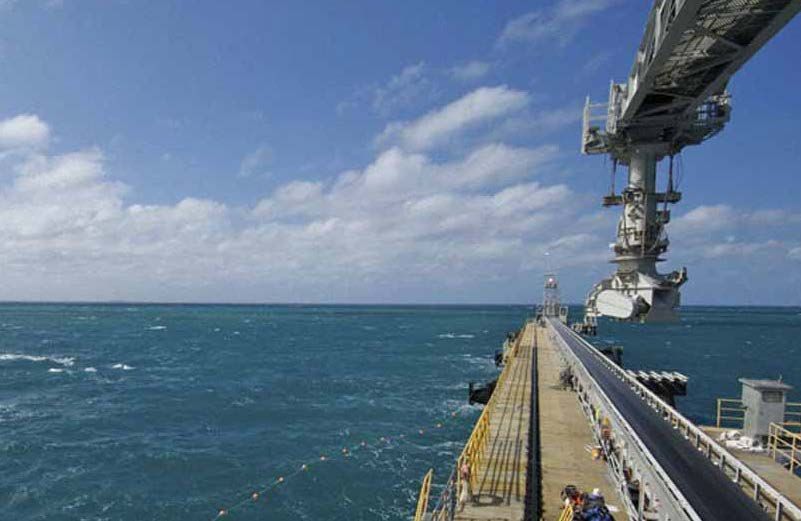
5.1.1 Main wharf
This is situated at the southern tip of Cape Flattery off a rocky headland. The wharf area
runs in a 140° direction for 200 m and the wharf itself continues off this access in a 150°
direction for 210 m. There are two separate dolphins, the seaward dolphin is situated 65
m from the end of the wharf and is connected by a ‘flying fox’ cable car arrangement, and
the shore dolphin is connected by a short access ramp. There are six breasting dolphins
along the wharf face. A ship loader is situated on the wharf and traverses the length of
the wharf face. Minimum required air draft is 14.5 m. A conveyor system with a maximum
loading rate of 2000 tonnes per hour (average gross rate 1300 t/h) links the ship loader
and the stock pile ashore.
(Photo courtesy of Far North Queensland Ports Corporation Limited)
All vessels berth starboard side to. Engines must be kept on standby and all crew are
required to remain on board at all times. The berth is fitted with 17 quick release hooks
for the mooring lines. Vessels should use a minimum of fourteen good ropes when
securing; the use of wires is not permitted. Depth alongside is 14.1 m.
5.1.2 Service jetty
There is a small service jetty and ramp situated in the bay north of Cape Flattery. This
jetty is privately owned by the mining company, and is used for servicing the mine and
wharfage for the two lines launches with limited tug capability. These are provided by the
company to assist in running lines to the main wharf when berthing ships.
Note that the depths are subject to change. For the latest information, please consult the
Notices to Mariners.
Hard copies of this document are considered uncontrolled. Please refer to the Maritime Safety Queensland website for the latest version.
Port Procedures and Information for Shipping – Ports of Cape Flattery, Cooktown and Port Douglas, June 2020. 29You can also read