WORKSHOP ON TRANSBOUNDARY ISSUES IN MARINE SPATIAL PLANNING (WKTBIMP) - VOLUME 3 | ISSUE 64 - ICES
←
→
Page content transcription
If your browser does not render page correctly, please read the page content below

WORKSHOP ON TRANSBOUNDARY ISSUES IN
MARINE SPATIAL PLANNING (WKTBIMP)

VOLUME 3 | ISSUE 64
ICES SCIENTIFIC REPORTS

RAPPORTS
SCIENTIFIQUES DU CIEM

                          IC E S   INTERNATIONAL COUNCIL FOR THE EXPLORATION OF THE SEA
                          CIEM     CONSEIL INTERNATIONAL POUR L’EXPLORATION DE LA MER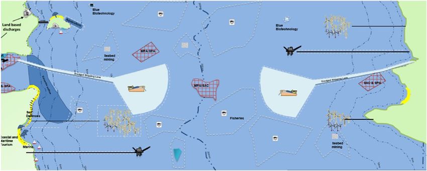
International Council for the Exploration of the Sea
Conseil International pour l’Exploration de la Mer
H.C. Andersens Boulevard 44-46
DK-1553 Copenhagen V
Denmark
Telephone (+45) 33 38 67 00
Telefax (+45) 33 93 42 15
www.ices.dk
info@ices.dk

ISSN number: 2618-1371

This document has been produced under the auspices of an ICES Expert Group or Committee. The
contents therein do not necessarily represent the view of the Council.

© 2021 International Council for the Exploration of the Sea.

This work is licensed under the Creative Commons Attribution 4.0 International License (CC BY 4.0).
For citation of datasets or conditions for use of data to be included in other databases, please refer to
ICES data policy.
ICES Scientific Reports

Volume 3 | Issue 64

WORKSHOP ON TRANSBOUNDARY ISSUES IN MARINE SPATIAL PLANNING
(WKTBIMP)

Recommended format for purpose of citation:
ICES. 2021. Workshop on Transboundary Issues in Marine Spatial Planning (WKTBIMP).
ICES Scientific Reports. 3:64. 26 pp. https://doi.org/10.17895/ices.pub.8210

Editors
Roland Cormier • Lodewijk Abspoel • Andrew Minkiewicz

Authors
Lodewijk Abspoel • Robert Adlam • Stacey Clarke • Michael Conathan • Roland Cormier •
Sondra Eger • Mike Elliott • Patrycja Enet • Anne Faure • David Goldsborough • Yves Henoc •
Ingela Isaksson • Stella Kyvelou • Caroline Longtin • Andrew Minkiewicz • Andrea Morf •
Rachel Mulholland • Caitriona Nicaonghusa • Victoria Poppleton • Ana Queiros • Rafael Sardá •
David Stevenson • Riku Varjopuro • Alastair Welch
ICES   |   WKTBIMP 2021                                                                                                                                               |   i

           Contents
           i      Executive summary ....................................................................................................................... ii
           ii     Expert group information ..............................................................................................................iii
           1      Introduction................................................................................................................................... 1
           2      Transboundary issues .................................................................................................................... 2
           3      Presentations and case studies ..................................................................................................... 4
                  3.1     European International Ocean Governance (ToR a) ........................................................ 4
                  3.2     Elevating and strengthening the profile and consideration of the ocean across
                          existing UNFCCC processes (ToR a) .................................................................................. 5
                  3.3     Baltic Sea cross-border coherence (ToR a) ...................................................................... 6
                  3.4     Shared stocks: Eastern Georges Bank (ToR b) ................................................................. 7
                  3.5     Baltic Sea tackling transboundary challenges and enablers (ToR c) ................................ 7
                  3.6     ICES Ecosystem overviews (ToR c) ................................................................................... 8
           4      Lessons learned from the workshop ............................................................................................. 9
           5      Enabler to address transboundary issues.................................................................................... 13
           6      Recommendations for next steps................................................................................................ 20
           7      References ................................................................................................................................... 22
           Annex 1:       List of participants.......................................................................................................... 24
           Annex 2:       Resolutions .................................................................................................................... 25
ii | ICES SCIENTIFIC REPORTS 3:64 | ICES
i Executive summary
The Workshop on Transboundary issues in Marine Spatial Planning (WKTBIMP) was held as
part of the terms of reference of the Working Group on Marine Planning and Coastal Zone Man-
agement (WGMPCZM). The aim of the workshop was to identify the key transboundary issues
that can undermine collaboration and coordination efforts to address them through marine/mar-
itime spatial planning initiatives.
Given the ongoing progress in marine planning international, transboundary issues between na-
tional marine planning initiatives are emerging as a significant challenge to sustainability within
a regional sea context. As part of the terms of reference for the workshop, case studies were used
to identify the key impediments in transboundary collaboration and coordination, to review the
roles of national marine plans and sector technical measures in achieving common transbound-
ary ecosystem, cultural, social and economic objectives, and to review the science needed for
effective and timely advice for planners involved in finding solutions to address transboundary
issues.
Based on lessons learned from the case studies, a myriad of transboundary issues in marine plan-
ning were identified stemming from governance systems, public policy, national legislation and
the different mandates of local, regional and national planning authorities including the stake-
holders that are involves in these processes. Recommendations for possible next steps identified
the need for: 1) the development of classification and taxonomy systems to highlight the differ-
ences between environmental and maritime transboundary issues including land-sea interac-
tions; 2) the development of assessment or evaluation techniques to identify the level of coher-
ence between planning initiatives and the implemented plans for planners; 3) an analysis of the
enablers and structures were used to find solutions to the impediments of transboundary issues;
4) an analysis of the coherence and linkages of the scientific knowledge regarding transboundary
issues and their use in marine planning; 5) theme session proposal for the next ICES Annual
Science Conference 2022 on this topic.ICES | WKTBIMP 2021 | iii
ii Expert group information
Expert group name Workshop on Transboundary Issues in Marine Spatial Planning (WKTBIMP)
Expert group cycle Workshop
Year cycle started 2021
Reporting year in cycle 1/1
Chair(s) Roland Cormier, Germany
Lodewijk Abspoel, The Netherlands
Andrew Minkiewicz, United States
Meeting venue and dates 29-31 March 2021, online meeting (24 participants)ICES | WKTBIMP 2021 | 1
1 Introduction
In marine planning, transboundary issues depend on the environmental and development policy
context. Expressed through conventions and legislation, the EU Marine Strategy Framework Di-
rective (MSFD); (EU, 2008; EU, 2017) is a notable example of an environmental policy that estab-
lishes good environmental status as the objectives to be achieved through programmes of meas-
ure of human activities and their pressures. In contrast, the EU Maritime Spatial Planning Di-
rective (MSPD); (EU, 2014) is an example of a development policy that establishes sustainable
economic growth, sustainable development of marine areas and sustainable use of marine re-
sources as the objectives of spatial and temporal apportionment of human activities. From these
two examples, environmental and development transboundary issues can occur where the man-
agement of activities within the boundary of a given jurisdiction causes effects or conflicts within
the boundary of neighbouring jurisdictions or undermine the good environmental status of an-
other jurisdiction. Defined by the United Nations Convention on the Law of the Sea (UNCLOS)
(UN, 1996), the boundaries of neighbouring jurisdictions are the territorial seas, the contiguous
zones, the exclusive economic zones (EEZ) and the continental shelf claimed by coastal states.
Outside these areas, environmental and development issues can occur between the activities
where jurisdiction is established by flag of the state of the vessels operating in the High Seas.
Derived from the terms of reference of the Working Group on Marine Planning and Coastal Zone
Management (WGMPCZM), the Workshop on Transboundary Issues in Marine Spatial Planning
(WKTBIMP) was held as a three half-day virtual meeting, 29–31 March 2021 (Annex 2: Terms of
reference). The agenda examined the roles of the territorial seas, contiguous zones, exclusive
economic zones, the continental shelf and the high seas as the boundaries for marine spatial
planning initiatives. Based on lessons learned from examples of transboundary marine spatial
planning initiatives in the Europe and the United States, transboundary issues emerging from
the differences in legislation, decision-making processes and levels, as well as environmental
and development objectives were identified as impediments to collaboration and coordination
of marine planning initiatives across jurisdictional boundaries. Issues were also identified for
internal jurisdictional boundaries within territorial waters between a regional authority and
other authorities of the same state. More importantly, the participants discussed the necessary
enablers to avoid such issues becoming bottle-necks to the efficiency of a planning process, show
stoppers that stifle engagement and participation as well as train wrecks that can thwart plan-
ning initiatives all together (Cavallo et al., 2019).2 | ICES SCIENTIFIC REPORTS 3:64 | ICES
2 Transboundary issues
Transboundary issues requires an understanding of the boundary being used to identify the is-
sues that would arise in coastal, marine and maritime planning (Figure 1). Environmental and
socio-economic development issues may arise across various atmospheric, topographic and hy-
drographic scales from land-sea interactions, whole ocean basin or European regional seas effects
as well as global effects such as the effects of climate change. Nevertheless, these issues reflect
the differences in legislation and policies that are used to manage maritime activities and across
sectors within national, regional and global jurisdictions. For example plastic and other litter
pollution are observed at global scales while the major inputs of plastics are from upstream and
terrestrial sources that are managed by different national regulatory frameworks. This implies
that solving plastic pollution globally ultimately depends the equivalence of the technical
measures implemented in such frameworks (Raubenheimer and Urho 2020).
Figure 1. Transboundary issues between internal and external jurisdiction (Elliott, Borja, and Cormier 2020).
The transboundary issues identified within a given jurisdictional boundary may be caused by
endogenic pressures and conflicts that would need to be addressed by national marine planning
processes linking coastal zones and territorial seas within their respective exclusive economic
zones. However, the issues identified with a given jurisdiction may be cause by external pres-
sures and conflicts that ultimately requires bilateral or multilateral collaboration and coordina-
tion and even conflict resolution across exclusive economic zone boundaries. Issues can be char-
acterized across multiple spatial and temporal scales.
Not all issues can be address through spatial and temporal allocation of activities to address
environmental and development objectives (Table 1). For example, health and safety concerns
emerging from vessel traffic and renewable energy infrastructure or environmental concerns
emerging from physical disturbances to the seabed have spatial characteristics that can be ad-
dressed by spatial allocation in a marine plan. However, non-spatial issues emerging from noise
and light disturbances to other maritime users or the marine biota cannot not be addressed
through a physical spatial allocation. They need additional management targets or standards to
reduce their overall impact intensity, spatial impact coverage and their temporal occurrence.
These issues can also be characterized as management challenges within and outside the bound-
aries of a given jurisdiction outside or from issues that do not have clear spatial boundaries (El-
liott et al., 2020, 2017) as well as mismatched and overlapping boundaries in relation to actual
social-ecological processes. Marine spatial conservation has, so far, been too much focused onICES | WKTBIMP 2021 | 3
static features in spatial management because they are spatially identifiable (Cormier et al., 2019;
Mach et al., 2017; Obura, 2018).
Table 1. Differences between spatial issues and non-spatial issues.
Spatial issues Non-spatial issues
Maritime users Maritime users
• Health and safety hazards from spatial use • Accidental spills and release
• Encroachment users activities • Aesthetics of the seascape
• Displacement of users • Noise and light
Marine environment (MSFD: EU, 2017) Marine environment (MSFD: EU, 2017)
• Disturbance of species (e.g. where they breed, • Extraction of, or mortality/injury to, wild spe-
rest and feed) due to human presence cies (by commercial and recreational fishing
• Physical disturbance to seabed (temporary or and other activities)
reversible) • Input of other substances (e.g. synthetic sub?
• Physical loss (due to permanent change of stances, non-synthetic substances, radionu-
seabed substrate or morphology and to ex- clides) — diffuse sources, point sources, at-
traction of seabed substrate) mospheric deposition, acute events
• Input of other forms of energy (including • Input of litter (solid waste matter, including
electromagnetic fields, light and heat) micro-sized litter)
• Input of anthropogenic sound (impulsive,
continuous)
Transboundary issues may also arise due to the differences between marine spatial policies,
planning processes and management systems used with the spatial boundaries of jurisdictions.
Planning is not only influenced by environmental concerns and development trends, (political
and societal) targets and baselines are continuously changing during the planning processes and
even after the implementation of the plan because of societal perceptions, changing political pri-
orities or the urgency of an issue arising. Although differences in monitoring including data
availability, homogeneity, and interpretation of the data, the management information and what
is perceived and used as being the evidence for MSP across jurisdictions is most often mentioned.
Transboundary issues may be grounded in the differences of institutional planning mandates
and sector management approach combined with different capacities of planning administration
as well as conflicting values and interests across stakeholder communities. Issues may also
emerge from differences in legislation and regulatory requirements from the flag states operating
in the high seas.
The challenges and impediments to resolve such issue requires bi-lateral and multi-level collab-
oration management processes between the competent authorities mandated for marine plan-
ning across jurisdictional boundaries may they be internal territorial waters or between exclusive
economic zones.4 | ICES SCIENTIFIC REPORTS 3:64 | ICES
3 Presentations and case studies
Six presentations and case studies provided insight into transboundary issues considering Euro-
pean oceans policy, the coherence of marine planning initiative across borders and fisheries man-
agement negotiations. ICES Ecosystem Overviews were also discussed as a mean of providing
coherent scientific advice in such planning processes.
3.1 European International Ocean Governance (ToR a)
Based on a consultation process lead by the European Commission in 2020, the summary of the
results of the targeted consultation on international ocean governance was presented within the
context of transboundary issues. The key recommendations from this process are:
Maritime spatial management
• MSP and ICZM, as applicable, should take into account cumulative impacts of ocean
stressors at a consistent standard globally and include provisions for Environmental
Impact Assessments (EIAs) and/or Strategic Environmental Assessments (SEAs).
• Such actions should become an integral part of the ocean governance framework at an
international and EU level to avoid negative environmental and climate externalities,
while improving socio economic benefits including for communities.
• Special emphasis should be given to economic and social considerations, as well as to
scientific guidelines, when adopting MSP measures.
• Maritime spatial management decisions need to respect the need to achieve and main-
tain Good Environmental Status.
Marine spatial management for environmental considerations as climate change, pollution,
and biodiversity
• The climate dimension should be better reflected in ocean governance priorities, possi-
bly through a dedicated pillar of adaptive and anticipatory processes including moni-
toring schemes to reflect cumulative effects.
• Emphasis on climate policies within the maritime affairs framework should contribute
to decarbonise the maritime sector, improve climate resilience of the ocean and coastal
communities, and ensure policies and management schemes are climate change proof.
• Similar to climate change adaptation and mitigation, the protection and conservation
of biodiversity should be among the guidelines for policy making on maritime affairs
and should be included in the IOG Agenda.
• The EU should strengthen its effort to protect biodiversity both within and outside of
national jurisdiction.
• The EU should ensure the protection and sustainable use of ocean, seas and marine re-
sources with cross sectoral conservation measures for all maritime economic activities
and the sustainable use with sector specific measures integrating relevant environmen-
tal concerns in close cooperation with the organisations mandated with marine envi-
ronment protection and conservation.ICES | WKTBIMP 2021 | 5
• The EU should maximise its efforts to build a coherent, well managed and ecologically
representative network of protected areas in view of achieving the protection of 30% of
the oceans by 2030.
• The EU should promote a holistic approach to ocean conservation and integrated
ocean management at the international level, i.r.t. ambitious climate goals and the 2030
agenda objectives.
• Marine pollution needs further attention in terms of regulation (mainstreaming in non-
ocean related relevant policies like agriculture) and in ensuring full implementation of
existing legislation and policies.
• Further research to identify pollution sources, while monitoring and control are im-
portant tools towards effective implementation.
• Additional efforts are needed to clean the oceans from existing polluting substances.
3.2 Elevating and strengthening the profile and considera-
tion of the ocean across existing UNFCCC processes
(ToR a)
The ocean is becoming an increasingly important part of the climate change conversation under
the United Nations Framework Convention on Climate Change (UNFCCC). In order to bring
more evidence and discussion about the ocean in climate policy arena, the UNFCCC has initiated
the dialogue with governments. Under the UNFCCC process, governments agreed to undertake
concrete activities addressing the ocean, coastal areas and ecosystems to inform adaptation plan-
ning and actions at the regional, national and subnational level. All National Adaptation Plans
(NAPs) submitted to the UNFCCC Secretariat to date, include projects on ocean and coastal
zones. Over 70% of Nationally Determined Contributions (NDCs) mention ocean-related topics
with the dominant issues being: coastal impacts, ocean warming impacts, fisheries impact, ocean
research and marine ecosystem impacts.
The Subsidiary Body for Scientific and Technological Advice (SBSTA) of the UNFCCC has iden-
tified that systematic observation and research is needed to fully understand the role of the ocean
in climate change, predict changes, determine risk and appropriate action. The SBSTA is further
mandated, under the Research and Systematic observation agenda item, to encourage Parties to
support the Global Climate Observing System (GCOS), invest in systematic observation and re-
search of the ocean. The SBSTA 50 (June 2019) mandated several actions under the thematic area
of oceans including at the Nairobi Work Programme on impacts, vulnerability, and adaptation
to climate change (NWP) that has established in 2019 the thematic area of oceans, coastal areas
and ecosystems, including mega deltas, coral reefs and mangroves 1. A range of activities under
the NWP is in progress to advance action through knowledge in this thematic area. At COP25,
the NWP organized for Parties the 13th Focal Point Forum on the ocean 2 to discuss knowledge
gaps and required collective actions for advancing adaptation of the ocean, coastal areas and
ecosystems. These works are carried out by the UNFCCC-mandated NWP Expert Group on the
Ocean 3 in the area of the adaptation knowledge gaps in the topic of the ocean, coastal areas and
ecosystems, including mega deltas, coral reefs and mangroves as well as slow onset events. In
1 https://www4.unfccc.int/sites/NWPStaging/Pages/oceans-page.aspx
2 https://unfccc.int/event/13th-focal-point-forum-of-the-nairobi-work-programme-on-the-ocean
3https://unfccc.int/topics/adaptation-and-resilience/workstreams/nairobi-work-programme-nwp/workshops-meet-
ings/second-meeting-of-the-nwp-expert-group-on-the-ocean-17-18-june-2020#eq-16 | ICES SCIENTIFIC REPORTS 3:64 | ICES
addition, various substituted bodies at the UNFCCC are involved in addressing ocean issues
through their work programmes, including the Warsaw International Mechanism on Loss and
Damage (WIM), the Technology Executive Committee (TEC), the Adaptation Committee (AC).
At COP 25, Parties agreed to launch an official Ocean and Climate Dialogue under the auspices
of the UNFCCC 4. The dialogue in December 2020 provided a space for Parties and non-Party
stakeholders to discuss how to strengthen adaptation and mitigation action on oceans and cli-
mate change, drawing on the knowledge and scientific findings from the IPCC Special Report
on the Ocean and Cryosphere in a Changing Climate (SROCC 2019) 5. Under the Marrakech Part-
nership for Global Climate Action (GCA), ocean and coastal zone are a key theme of the UN-
FCCC global climate action agenda, which has provided a platform for stakeholders to collabo-
rate on ocean and climate change action towards COP26 6.
3.3 Baltic Sea cross-border coherence (ToR a)
A checklist for cross-border coherence of marine spatial plans currently in development was
presented as part of the HELCOM-VASAB MSP working group. The checklist is being developed
to ensure that maritime spatial plans are coherent and coordinated across Baltic Sea. Practical
solutions being considered include transboundary consultations at regional sea level, bi-lateral
and tri-lateral coordination to address issues through several joint project of MSP authorities.
Although there is a lot of work towards coherence, coherence per se is not yet defined.
A task force established in 2019 has been developing a method to assess cross-border coherence.
The approach being examined to assess coherence involves matching and comparison of plan-
ning decision across borders analysing potential mismatches. It also examined planning deci-
sions and principles in line with their intended effects which are functions that go beyond the
physical maps. The steps of the assessment approach includes:
1. Scoping: Topics that require cross-border attention are screened and an under-
standing of their cross-border relevance. Cross border topics of ‘particular concern’
are analysed in terms of the distance from the border that they can have negative
or positive influence across the border.
2. Assessment. The coherence of how the relevant topics are being handled by plan-
ning initiatives are analysed in terms of the differences in handling or presenting
the topic in marine spatial plans and related documents. The differences are then
assessed in terms of their potential problems and risk. More importantly, the solu-
tions are also assessed to minimize the problems and the risks as well as foster
synergies.
The method does not measure coherence directly given that such an approach is not a scientific
exercise as it is a coherence evaluation of potential problems to identify solutions. This approach
facilitates dialogues between jurisdictions as a structure process.
Key guidance documents are also available:
• Guidelines on transboundary consultations and cooperation in the field of MSP
• Guidelines on public participation for MSP with transboundary dimensions
4https://unfccc.int/event/ocean-and-climate-change-dialogue-to-consider-how-to-strengthen-adaptation-and-mitiga-
tion-action
5 https://www.ipcc.ch/srocc/
6https://unfccc.int/climate-action/marrakech-partnership/reporting-tracking/pathways/oceans-and-coastal-zones-cli-
mate-action-pathway#eq-1ICES | WKTBIMP 2021 | 7
• Guidelines on the application of Ecosystem Approach in transnationally coherent
MSP
3.4 Shared stocks: Eastern Georges Bank (ToR b)
A case study was presented regarding transboundary issues resulting from legislative differ-
ences between the United States and Canada regarding the rebuilding of ground fish stocks of
the Eastern Georges Bank. The US-Canada Transboundary Resource Sharing Understanding and
their scientific and management committees were discussing rebuilding plans for this fishery.
The differences were rooted in the Magnuson-Stevens Fishery Management Act (MSA) requires
that all overfished stocks must have a rebuilding plan for recovery within 10 years while at the
time the Canadian Fisheries Act did not have such provisions until 2019. The issues arose after
the MSA reauthorization in 2006 where the United States is mandated to set allowable catch
limits to meet aggressive rebuilding time line for overfished stocks. These limits were dramati-
cally lower than the catch limits being sought by Canada.
It took an Act of Congress to resolve the issues through the International Fisheries Agreement
Clarification Act 2010 (IFACA). Given the public and stakeholder concerns being raised through
the reauthorization process of the MSA, the IFACA was the only way to move forward with the
negotiations for the Eastern Georges Bank as it would not be construed to amend the MSA.
3.5 Baltic Sea tackling transboundary challenges and ena-
blers (ToR c)
Several research initiatives were presented for the Baltic Sea Region that focused on ecological
sensitivity and diversity within the context of shared and diverse social context related to trans-
border marine spatial planning as well as implementing the MSPD. This research focused on the
need for a strong role of regional planning organization leading such process through collabora-
tion of multi-level governance. Marine spatial planning initiatives are in the region are at differ-
ent stages and capacities. The developed MSP Plans by the Baltic Sea’s Member States can be of
a different character – some of them are prescriptive and some are indicative. Some countries,
e.g. Finland, developed their MSP by taking an approach from the coastline towards the marine
areas, in this way making the land-sea interactions an integral part of the plan.
As of December 2020, Finland had adopted its marine spatial plan while Sweden started the
process for adoption. Besides historical transboundary issues from the ratification of UNCLOS
in 1982, there are grey zones of contested borders such as Bornholm and EEZ border between
Latvia and Lithuania. The Baltic Sea also includes the Russian Federation which is a non EU
member.
Several research and interregional collaboration projects have contributed to the advancement
of marine spatial planning initiatives in the Baltic Sea including through the interregional pro-
grammes on transboundary collaboration in Europe – INTERREG, and through the research pro-
grammes such as the EU Framework Programme for Research and Innovation H2020. Examples
of the projects include: BONUS, EMFF, SEAGIS, PlanBothnia, BaltCoast, BaltSeaPlan,
PartiSEApate, BaltSpace, BONUS, BASMATI, Baltic SCOPE, Pan Baltic Scope, and Interreg Cen-
tral Baltic with a sub-programme on the Archipelago and Islands.8 | ICES SCIENTIFIC REPORTS 3:64 | ICES
Lessons learned from these initiatives point to the need for:
• knowledge sharing across border;
• multi-level governance with clear mandates to collaborate across border;
• Still need to link more and know & learn more across; and,
• Involvement of academia advisory roles and support.
Generally, transboundary issues between marine spatial plans across EEZs in the Baltic Sea is
similar to national cross-jurisdictional issues in onshore planning or coastal planning
3.6 ICES Ecosystem overviews (ToR c)
ICES has been producing Ecosystem Overviews to inform management by providing a descrip-
tion of the ecosystems, identifying the main human pressures, and explaining how these affect
key ecosystem components. Depending on the regional seas, some overviews provide a more
extensive overview compared to others as is the case for the Celtic Seas. Although marine plan-
ners have access to these overviews as guidance regarding transboundary issues, planning initi-
atives need much more specific details to address transboundary issues. The participants pro-
vided the following regarding the use of ecosystem overviews in marine spatial planning
• They provide an overarching framework and have been used with stakeholders
and, more specifically, fisheries management processes.
• There would be a need for guidance as to what information within the overviews
could be used these overviews in marine spatial planning as we as a need to raise
awareness with policy makers, planners, the general public, scientists and advisory
groups.
• There is a need to standardize the structure and establish a naming convention that
includes jurisdictional and fisheries boundaries.
• There is a need to ensure coherence between quality status reports as by OSPAR
given that these commissions have a mandate to review the condition of the mari-
time areas. There is not a clear link between ecosystem overviews which are con-
sidered as reference material for quality status reports that are produced through
established indicators used to report along thematic areas.ICES | WKTBIMP 2021 | 9
4 Lessons learned from the workshop
Competent authorities can only plan and address issues that are within the scope of the author-
ities provided by their legislative framework and the context of the mandate given by their re-
spective governments. Marine spatial planning as in any type of land-based and coastal plan-
ning, depending on the jurisdiction, requires an interdisciplinary approach given the broad
range of environmental, cultural, social, economic, legal, and governance issues that have to be
addressed (or taken into account); for which in all cases adequate communication and stake-
holder engagement are required (Eger and Courtenay, 2021; Eger et al. 2021). Impediments to the
planning process as well as the adoption of the plan lies in the abilities and capacities of the
administrations leading these planning processes and the competent authorities of the various
sectors to implement the plans that is more tightly linked to legislation and policies than the
scientific and technical information that has to be brought to bear for decision-making (Stephen-
son et al., 2019). However, it is the objectives given within the mandate of the planning authority
that has to be clearly understood by government employees, stakeholders, and scientists in-
volved in terms of either marine spatial environmental planning or maritime spatial develop-
ment planning. Transboundary issue can also arise between these two planning paradigms.
The lessons learned from the workshop case studies and discussions do identify a broad range
of coherence issues that spans institutional and planning designs across the jurisdictions within
national borders and across borders within regional seas and management areas (Table 2). There
would be a need to conduct further forensic analysis from the vast number of marine spatial
planning case studies that are available today. Such analysis would examine if and how trans-
boundary issues have been solved and what were their approaches, as well as the enables that
brought about solutions from a more generic perspective. An analysis of MSP revisions should
also be examined to ascertain if transboundary issues were identified given that MSP is a contin-
uous cyclic process (e.g. definition, preparation, implementation and revision); (Zaucha and Gee,
2019).10 | ICES SCIENTIFIC REPORTS 3:64 | ICES
Table 2. Lessons learned from the case studies presented and the workshop discussions.
Marine Social
Institutional charac- Use of MSP or other
Case studies Ecological Systems Challenges Learning so far
teristics approaches
(SES) characteristics
semi-enclosed sea HELCOM (non-bind- TB planning issues
shallow sea ing agreements) Many countries Lots of learning in
increasing pressures VASAB Many different sys- terms of TB i interac-
focus on MSP Land-
sensitive ecosystem 9+ countries tems tion and problem
sea interactions
Baltic Sea many different types Mostly EU + Russia smaller contested solving within EU
multi-dimensional
of coasts zones (grey zones in and HELCOM/
Good international approach
UNCLOS) VASAB collaboration
fisheries as cultural collaboration and
activity under threat history of collabora- National sovereignty Research projects
CC as threat tive problem solving vs EU influence
OSPAR (binding
Intensively used ma-
agreements on pro-
rine area, cumulative
shallow and deeper tection of biodiver-
impacts, ocean resto-
sea sity)
MSP & LSI ration,
high sea/blue econ- long institutional his- Learning and institu-
Fewer incentives
omy dependency of tory tional collaboration
North Sea similar to BS, Norwe- forcing collaboration.
many countries/ is- BREXIT and more in projects and EU
gian mgmt plans National sovereignty
lands non-EU countries – Research projects
vs EU influence
cultural traditions re- working jointly when
Issue of subsidiarity
lated to sea of added benefit
related to member
(north sea energy co-
states
operation)ICES | WKTBIMP 2021 | 11
The Land-Sea inter-
action article becom-
ing highly relevant in
an area with an
ICZM Protocol that
multiple countries,
semi-enclosed area focus on ICZM (e.g. makes different refer-
half non EU, great in- migration & security,
Barcelona conven- ences to MSP and the
deep and shallow stitutional fragmen- contested areas (grey
tion) validation of the Eco-
Mediterranean islands tation, existence of zones in UNCLOS)
political issues al- system Approach
migration as im- macro-regional coop- geopolitical struggles
most outside of MSP strategy approved by
portant issue eration strategy (EU- linked with energy
discussion all parties. Learning
SAIR)
and collaboration in
projects across the
sea-basin have been
initiated through
UNEP-MAP
Workshops focused
on the Western At-
lantic as well as Eu-
large scale case, large Size ropean initiative (e.g.
MSP and other in-
marine area, large SIMAtlantic) Sup-
territorial waters, struments (e.g., inte- Connectivity
Atlantic marine mammals is- porting Implementa-
EEZ & High Seas grated management culture vs environ-
sues, multiple eco- tion of Maritime Spa-
plans) ment issues
system types tial Planning in the
Atlantic
(https://www.simat-
lantic.eu/).
territorial waters, Non-MSP or MSP
Specific transbound- marine transporta-
EEZ & High Seas coming in secondar-
ary use case tion, increasing
IMO as basic context ily12 | ICES SCIENTIFIC REPORTS 3:64 | ICES
globally hot/ conflic-
tive area
CC & ocean acidifica- territorial waters, Lack of framework of
tion highly sensitive EEZ & High seas enforcement
ecosystem, large con- PAME / Arctic Coun- Lack of strong incen-
Arctic Council learn-
Arctic tested areas, CC and cil - now shifting Non-MSP so far tives to collaborate
ing?
ice cover changes, in- again from environ- multiple planning
vasive species can mental to strategic systems involved
cross the Arctic, and security issues that have so far not
coordinated across
borders
Differences in ap-
territorial waters, proaches between
EEZ & High Seas government led and
hot issues, highly
Global power differences Approach missing local community led, MSPglobal initiative?
sensitive ecosystems,
capacity and devel- often linked to eco-
opment differences nomic development
state of nation.ICES | WKTBIMP 2021 | 13
5 Enabler to address transboundary issues
Harmonized marine spatial planning frameworks can provide a common denominator between
jurisdictions to help resolve and address transboundary issues. Both European MSFD and MSPD
provide such framework that establishes common objectives, principles for planning processes
and management context for implementation (Stephenson et al. 2019). As discussed above, it is
the mandate to collaborate and coordinate marine and maritime spatial plans that is needed to
address transboundary issues. That is somewhat different from institutions that have scientific
and technical mandate to generate the knowledge needed to inform decision-making processes
in planning and plan implementation such as HELCOM, OSPAR and ICES.
Transboundary issues lie in the connectivity of many aspects. Based on the ‘Ten tenets’ of adap-
tive management and sustainability (Barnard and Elliott, 2015), Table 3 could provide a template
to identify the transboundary issues and analyse the impediments to resolving the issues and,
more importantly, identify the means of overcoming the impediments.14 | ICES SCIENTIFIC REPORTS 3:64 | ICES
Table 3. The types of connectivity and their meaning in a transboundary context.
Types of
connectiv- Meaning and relevance in a transbound- Impediments to ensuring the con- Means of overcoming
Examples
ity/equiva- ary context nectivity the impediments
lence
That the laws and agreements either side of
Each state is a member of the Greater direction in im-
the boundary are compatible and equiva-
EU and so following the Di- Member states are not implement- plementing the agree-
lent (in the spirit if not in the letter of the
rectives, and that each state ing directives in the same way; ments and directives;
Legislative law); that the linking points either side of
is a signatory to regional they are not both members of the the need to carry out in-
connectivity the boundary in the vertical hierarchy of
seas conventions and inter- EU, they are not signatories to con- ter-comparison exer-
laws and agreements (from the local,
national agreements such as ventions or agreements. cises to ensure compati-
through national and regional to interna-
UNCLOS, IMO, etc. bility.
tional) are known.
There are trade barriers between
That the industries and activities occurring High level removal of
the areas or barriers in obtaining
either side of the boundary are linked and Companies are the same ei- trade barriers and
permissions for carrying out activi-
Economic interdependent and that those responsible ther side of the boundary, or adoption of similar and
ties; there are different environ-
connectivity for either their execution or management they have the same business non-discriminatory EIA
mental impact assessment and pro-
are subject to the same constraints and model. and protected area as-
tected area regulations which put a
practices. sessments.
company at a disadvantage.
Harmonisation of the
regulations or at least of
Regulations for the use of the wa-
That the corresponding sectors either side The fishing grounds cover their outcomes; equiva-
ters or the seabed differ between
of the boundary (fishing, aquaculture, oil the boundary, there are lence of industrial regu-
Sectoral con- areas; there are differences in quota
and gas extraction, offshore renewables, straddling fish stocks; off- lations including fisher-
nectivity arrangements (size, species, season
shipping, etc.) are subject to the same con- shore wind farms occur ies management. Con-
limits, and discard rates for fishing
straints, management and practices. across the boundary flict resolution tech-
or in permit systems.
niques are used in dis-
putes.
Connectivity That the areas occupied by a particular ac- That the pressures and effects-foot- A better knowledge of
A windfarm one side im-
of activity-, tivity, the area covered by the pressures (as prints cannot be determined even if the activities in an area
pacts the water movements
pressures- mechanisms of change emanating from the the site of the activity is known and in relation to the localICES | WKTBIMP 2021 | 15
and effects- activity) and the areas showing the societal on the other side; pollutants licensed. No or limited cumulative dynamics and transport
footprints and natural effects of those pressures are move across the boundary effects assessments are undertaken of materials and im-
known in relation to the presence of a during permitting activity. pacts; similar methods
boundary and that they can be managed for cumulative impacts
singly and cumulatively; that the pressures assessment are used.
and effects on one side of a boundary but
emanating from activities on the other side
are known and are able to be controlled.
That the same bodies are responsible for That the different bod-
Irrespective of the countries,
marine management either side of the ies agree to work to-
the OSPAR regional seas
boundary at a higher level (e.g. RSC or in- That the different states have a mis- gether and harmonise
convention covers both sides
ternational convention) or that at a lower match in administrative bodies their ways of working;
Administra- of the boundary; each side
level (e.g. nation, region, municipality, etc.) such as a lack of a marine manage- that there is a good
tive connec- has an Environmental Pro-
they have equivalences in terms of duties ment body in favour of merging knowledge exchanged
tivity tection body, a Nature Con-
and procedures; that the horizontal integra- terrestrial and marine manage- of what are the compe-
servation body and an Activ-
tion of these administrative bodies on each ment. tent organisations and
ity Management body with
side of the boundary occurs and allows ho- what are their compe-
equivalent duties.
listic and integrated marine management. tencies.
That the same approaches and practices of
MSP are used on both sides of the bound-
That wide-ranging MSP
ary or that there is an equivalence of out- Countries on both sides of One of the states does not practice
Connectivity practices are adopted
comes and outputs if different approaches the boundary follow the EU MSP or one state allocates seabed
of Maritime by different countries
and practices are used; that zoning or space MSPD and plan the seabed use according to where an activity
Spatial Plan- but that the MSP out-
allocation practices on one side of the use according to a given set could be rather than where it
ning comes have equiva-
boundary do not disadvantage groups of of characteristics. should be.
lence.
stakeholders on the other side of the bound-
ary.
One of the states does not have a
That the methods used for monitoring (the Good Environmental Status That there is coordina-
comprehensive monitoring pro-
natural and societal features) either side of of the benthos and seabirds tion between the moni-
Monitoring gramme or its monitoring methods
the boundary are the same, are inter-cali- are monitored using the toring programmes,
connectivity and standards are incompatible
brated and inter-compared, are on the same same methods on both sides that common methods
with providing a coherent status
elements producing equivalent data, or that of the boundary. are adopted and that in-
assessment of species or habitats.16 | ICES SCIENTIFIC REPORTS 3:64 | ICES
there are compatible outputs and the same ter-comparison and in-
outcomes irrespective of the methods used. ter-calibration exercises
are used as necessary to
harmonise the outputs
and outcomes.
That there is coordina-
That the methods of assessment and the tion between the assess-
forms and lines of reporting are the same ment and reporting
either side of the boundary, e.g. that the The benthic indicators (e.g. based on accepted
There are no suitable indicators or
same indicators and indices are used, that MAMBI) are used either side guidelines, that com-
Assessment there are different indicators either
the same combination or weighting tech- of the boundary; the one- mon methods and indi-
and reporting side of the boundary; the reporting
niques are used and that they refer to the out-all-out method is used ces are adopted and
connectivity is not consistent in spatial or tem-
same or corresponding elements; that there both sides for combining that inter-comparison
poral scales or its timing.
are equivalence of outputs and outcomes quality indicators and inter-calibration ex-
which can be collated and reported to give ercises are used as nec-
a complete picture. essary to harmonise the
outputs and outcomes.
Not applicable if the
natural state prevents
connectivity. Where
Not applicable if the natural state
That the water characteristics and hydro- The salinity conditions and possible and economi-
prevents connectivity. Human de-
graphic patterns either side of the boundary the water masses are similar cally allowed, human
Physico- velopments and structures imped-
and between the areas on both sides of the on both sides of the bound- developments and
chemical con- ing water movements and thus the
boundary are known and not distorted by ary and links and there is no structures impeding
nectivity links between the physico-chemical
human activities occurring in one or both oceanographic front to pre- water movements and
systems would need to be re-
areas across the boundary. vent connectivity thus the links between
moved.
the physico-chemical
systems should be re-
moved.
That the populations and communities ei- A resident population of a Not applicable if the natural state
Not applicable if the
Ecological ther side of the boundary are connected ei- sedentary benthic species oc- prevents connectivity. Human de-
natural state prevents
connectivity ther by migration patterns or by the larval curs in both areas with dom- velopments and structures imped-
connectivity. Where
dispersal and settlement patterns, and that inant currents moving from ing water movements and thus theICES | WKTBIMP 2021 | 17
there are no interferences such as oceanic one to the other and taking links between the ecological sys- possible and economi-
fronts or human activities preventing that planktonic stages from one tems would need to be removed. cally allowed, human
connectivity. to the other within the time developments and
for metamorphosis thereby structures impeding
ensuring genetic connectiv- water movements and
ity. thus the links between
the ecological system
should be removed.
Nature conservation of habitats
Not applicable if the
and species is managed by differ-
priority species and
ent practices one the sides of the
habitats are not the
boundary; the populations of
The two sites have defined same; equivalence can
That there are the same practices of nature highly mobile and migratory spe-
the same benthic habitat be achieved using func-
Coastal and conservation and restoration on each side of cies of conservation importance are
units and indices of habitat tional groups instead of
marine con- the boundary in relation to species and hab- influenced by developments away
quality, for example there species names and habi-
servation con- itats, that habitat units are treated equally, from the areas, e.g. in breeding or
are biogenic reefs either side tat major types can be
nectivity and that species are given the same protec- nursery areas. Human develop-
of the boundary which are harmonised; a better
tion, especially for highly mobile species. ments or structures can create im-
designed as priority habitats. knowledge of highly
pediments to population move-
mobile species can help
ments. Different priority species
to achieve conservation
and habitats occur or are so desig-
outcomes.
nated.
The states either side of the
boundary use similar guide-
That the different states use differ-
lines for marine conservation
ent methods, guidelines and ap- That coherence between
That methods of designating Marine Pro- zones as well establishing
MPA-desig- proaches to MPA designation, that methods is achieved or
tected Areas are equivalent and compatible; and managing marine pro-
nation con- the priority species and habitats are at least there is coher-
that any weighting mechanisms in conser- tected areas, including the
nectivity not compatible and that different ence between out-
vation prioritisation are compatible. principles of coherence, con-
spatial and temporal delimiting comes.
nectivity, representativity
methods are used.
and replication; that the
MPA legislation is guided by18 | ICES SCIENTIFIC REPORTS 3:64 | ICES
international conventions
and directives.
The two sides of the bound- That it is difficult engaging with Stakeholder engage-
That the same groups of stakeholders or
ary have defined groups of stakeholders either side of the ment and conflict reso-
groups of different stakeholders but with
Societal con- stakeholders covering those boundary, that the groups of stake- lution are practised;
the same desires and tolerances occur either
nectivity using the seas, managing holders differ or that there are no wide scale dissemina-
side of the boundary and that these require
them and benefitting from mechanisms for engaging with the tion of outcomes is
similar outcomes.
the uses. wider society. agreed.
Mediation techniques
That any indigenous peoples either and behavioural assess-
Native and first nation
That any indigenous groups which occur side of the boundary have incom- ments are used. Tradi-
groups occur on both sides
Cultural con- on both sides of a boundary irrespective of patible values and traditions. tions are respected
of the boundary and are re-
nectivity the national state have similar protection Rights to resources differ from in- while striving for
garded similarly by both
with regard to the use of resources. digenous peoples across bounda- equivalence in out-
states.
ries. comes within the scope
of established rights.
That there is equivalence on both sides of a
boundary in the principles: sustainable de-
velopment (for ecology, economy and soci-
ety);
Summary - A wide adoption of
• inter-generational equity;
Connectivity These principles are embed- these principles is re-
and equiva- • the precautionary principle; ded in the governance on quired. Given that these
• conservation of biological diversity There is no equivalence in the
lence in gov- both sides of the boundary are embedded in states
and ecological integrity; adoption or implementation of
ernance ap- irrespective of whether the worldwide and in hori-
these principles.
proaches, • ecological and economic valuation; two states are in the same zontal and vertical pol-
principles • the ‘damager debt’ / ‘polluter pays’ bloc. icy integration then this
and outcomes principle; should be achievable.
• waste minimisation, and
• public participation - the role of indi-
viduals and ethics.ICES | WKTBIMP 2021 | 19
This is a non-exhaustive list to build on; language, rights and obligations of stakeholders, eco-
nomic resources in countries, the question of MSP decisions being politically sensitive or not,
and many other aspects come in to play. Transboundary does apply within States (e.g. States in
the USA, Provinces and territories in Canada), to neighbouring states, and to connections much
further (e.g. Norway – France or Canada – Ireland). Further reflection is needed how to incorpo-
rate shifting “locations” where marine species are living and the functioning of marine habitats
under changing climate and ocean conditions. In particular, where such shifts move species from
one EEZ to another, and has implications for fisheries agreements.20 | ICES SCIENTIFIC REPORTS 3:64 | ICES
6 Recommendations for next steps
The workshop highlighted a myriad of issues in marine spatial planning stemming from public
policy governance systems, the legislation and mandates bestowed to planning authorities to the
local and regional context of the stakeholders involved. The following are recommendations for
next steps that could be taken to help planners identify and address transboundary issues.
a) Identify the key issues in transboundary collaboration and coordination in marine/maritime spatial
planning within a regional sea context (Science Plan codes: 6.2);
• There is a need for a classification or taxonomy of transboundary issues that could help
planners involved in domestic and international initiative identify the issues. Table 3
could be used to start teasing out the issues and develop such classification system.
• There is a need for accelerating ocean-based climate solutions for enhanced NDCs and
NAPs given the importance of ocean-climate action to meet the Paris Agreement.
Strengthening adaption and mitigation through the ocean and climate change action
could be enhanced in transboundary MSP to maximize the potential of ocean based solu-
tions for climate action while ensuring other priorities, such as sustainable food produc-
tion and reversing biodiversity loss.
b) Review the different roles of marine planning and sector specific technical measures implemented to
achieve common transboundary ecosystem, cultural, social and economic objectives outlined in ma-
rine plans (Science Plan codes: 6.4);
• Coherence assessment or evaluation techniques could provide guidance for planners that
are trying sort out the level of coherence between planning initiatives and the plans them-
selves. These could also complement national environmental impact assessments and
strategic environmental assessments. Policy logic models that are typically used to eval-
uate the coherence of marine planning initiatives and the equivalencies of technical
measures could provide valuable insight in the development of such techniques linking
legislation, authority and mandate with planning outputs and implementation outcomes.
• A forensic analysis of selected case studies could also be undertaken to produce of review
paper on the issues with a particular attention to the enablers to find solutions to the
impediments to address transboundary issues in marine planning.
• An analysis of the transboundary issues from land-sea interactions in relation to marine
planning initiatives could be undertaken to understand the root causes of the fragmenta-
tion of competencies involved in such initiatives.
c) Review the science needed for effective and timely advice to planners involved in processes that have
to address and integrate regional sea policies (e.g. EU Marine Spatial Planning Directive (MSPD)
and Marine Strategy Framework Directive (MSFD)) including international conventions and
agreements (e.g. UN Sustainable Development Goal 14 and targets); (Science Plan codes: 6.3).
• A proposal for a theme session at the next Annual Science Conference planned for Dublin
in 2022 could generate a broader understanding of transboundary issues from an envi-
ronmental and development perspective. It would, however, primarily focus on enablers
and solutions to overcome the transboundary issues and improve the coherence between
marine spatial plans.
• An analysis of the coherence and linkages of the knowledge generated by scientific and
technical institutions such as ICES, OSPAR and HELCOM would also help promote a
better understanding of relevance of their work in marine spatial planning. This is in lineICES | WKTBIMP 2021 | 21
with ecosystem overviews currently generated by ICES. Recently, WKTRANSPARENT
has developed methods and guidelines to link human activities, pressures and state of
the ecosystem (ICES 2021).You can also read