Coastal Erosion and the Promontory Fort: Appearance and Use during Late Iron Age and Early Medieval County Waterford, Ireland - MDPI
←
→
Page content transcription
If your browser does not render page correctly, please read the page content below
sustainability

Article
Coastal Erosion and the Promontory Fort: Appearance
and Use during Late Iron Age and Early Medieval
County Waterford, Ireland
Edward Pollard *, Anthony Corns , Sandra Henry and Robert Shaw
 The Discovery Programme, Centre for Archaeology and Innovation Ireland, 6 Mount Street Lower,
 2 D02 T670 Dublin, Ireland; anthony@discoveryprogramme.ie (A.C.); sandra@discoveryprogramme.ie (S.H.);
 robert@discoveryprogramme.ie (R.S.)
 * Correspondence: edward@discoveryprogramme.ie; Tel.: +353-1-639-3724

 Received: 7 May 2020; Accepted: 14 July 2020; Published: 18 July 2020

 Abstract: Promontory forts are an understudied but distinctive maritime archaeological feature from
 the Iron Age to the early medieval period from northern Spain to Scotland. Their coastal location
 renders them susceptible to erosion and loss to history, a situation exacerbated by increased storm
 frequency and sea level rise. Reconstruction of their original form is important to determine their role
 in the society of the time. This paper concentrates on a particularly notable group of promontory
 forts along the Copper Coast of Co. Waterford, where traces of up to 32 remain today within a 24 km
 stretch of coastline. The methodology has involved using oral tradition, historical records and field
 survey. This has been enhanced by aerial survey using drones and light aircraft. This paper models
 the data to estimate areas eroded and show how forts were once significantly larger and dominated
 coastal resources with an economy of farming, fishing, mining and trading. This paper calculates a
 likely erosion rate of 4–5 cm/yr and anticipates the last remains to be lost in 350 years, perhaps sooner
 with climate change.

 Keywords: climate change; oral tradition; medieval coastline; aerial archaeology; mining; Celtic Sea

1. Introduction
      Anthropogenic climate change is a growing global threat to cultural heritage worldwide [1].
Therefore, an urgency to conduct coastal investigations is underlined by both the continuance of
erosional processes in a context of climate projections in Ireland that indicate an increased frequency
of storm surge events and heights, with the global mean sea level rising at 3 mm/year since 1993,
while models project a rise in sea level over the 21st century up to 2.5 m [2,3]. Previous historical work
on coastal erosion has looked at the early images and maps of the coast to determine the accuracy of this
evidence, the rates of change and the extent of erosion along the coast [4]. The study of historical maps
shows improved survey accuracy within the last couple of centuries but many sites were only surveyed
at a small scale. Improvements in aerial survey and remote sensing can show more recent differences
but understanding the extent of change over longer periods is more complicated and research has
relied on the preservation of sea level markers from palaeoenvironmental and archaeological material
after sea level rise and associated flooding [5].
      There have been several studies on the vulnerability of archaeological heritage to erosion (e.g.,
recording threats to a standing stone or palaeosol, [6,7]). However, attempts to reconstruct the
geomorphology around eroding sites have mostly looked at reconstructing sea level during lower
or higher stages during prehistoric periods, or during the last few centuries from paintings or
photographs [8,9]. In 1917, the village of Hallsands in Devon was eroded after shingle offshore was

Sustainability 2020, 12, 5794; doi:10.3390/su12145794                    www.mdpi.com/journal/sustainability
Sustainability 2020, 12, 5794                                                                         2 of 21

dredged [4] (p. 35). Few have looked at more long-term change over the last two millennia, where
headlands and bays would still have been under continual change after less dramatic changes in
sea level. For example, aerial photography and historic mapping suggest that 25% of the eroding
four-banked ringfort of Cahermore at Carrowhubbuck North in Co. Sligo has been lost since 1910 [10].
This normally circular Iron Age to early medieval type of settlement is shown in the early 19th-century
Ordnance Survey (OS) as D shaped, indicating that part had already been eroded away. A study
of Cretaceous chalk cliff retreats in East Sussex modelled a 2–6 cm/yr loss through the Holocene,
though the authors believed this had increased more recently from human intervention and higher
wave energy [11]. In Ireland, the CHERISH project has been gathering baseline data on the present
erosion of archaeological sites during fieldwork so future collapse can be measured accurately. Further,
archival data has been collected that refers to areas of erosion, which, although not as accurate as
modern remote sensing, can lead to information on the importance of sites, as they may have looked
significantly different to today. It is also possible to take the evidence of coastal erosion further back in
time, determining erosion rates by looking at uneroded monuments for comparison.
      One notable construction that is particularly vulnerable to eventual total loss consequent upon
its unique form and coastal location is the promontory fort. Promontory forts, though previously
under researched, are common archaeological sites located above the cliffs around the Irish and
Celtic Seas, linking these areas in a historic maritime culture with Britain and beyond. For the
archaeologist to understand how these sites were used, the task is made more difficult by their exposure
to approximately 1500–2000 years of erosion since they were first constructed. As the present coastal
cliffs of northern Europe have been exposed to sea erosion since the last Ice Age, the extent of coastal
change is difficult to determine, being dependent on factors such as aspect, weather patterns, physical
structure, rock type and human modification. This paper concentrates on a specific group of Iron
Age to early medieval promontory forts situated on the Co. Waterford coast of Ireland which are
particularly vulnerable to the elements.
      This study aims to determine what has already been lost and estimates the lifespan of what
remains. The forts are discussed in their environmental situation, using information from historical
sources and local knowledge, combined with recent aerial survey, to identify eroded features and
hypothesize their former extent while indicating the rates of coastal retreat. The evidence is combined
to suggest how promontory forts have changed since occupation, leading to greater understanding of
their former involvement in the maritime cultural landscape of the Celtic Sea.
      From a maritime perspective, the coastal promontory fort is easily seen from, and gives oversight
of, the sea. They are fortifications on promontories and headlands that are identified by one or more
banks and ditches cutting the peninsula off on their landward side. Previous work at promontory forts
in Ireland include O’Kelly’s excavations in Co. Cork at Portadoona to the east of Toe Head; Carrigillihy,
just within the entrance to Glandore Harbour; and Dooneendermotmore, beside Toe Head [12]. Others
include The Doon on the eastern side of Tory Island in Co. Donegal; Dalkey Island in south Co. Dublin;
and Larrybane Head on the north mainland coast near Rathlin Island in Co. Antrim [13–15] (Figure 1).
      The dating evidence from promontory forts is wide ranging. In Wales, on the Pembrokeshire
coast, there is surrounding Late Bronze Age evidence, but most promontory forts are thought to have
developed during the Iron Age [16] (p. 66). A promontory enclosure at Llansteffan Castle in Carmarthen
produced a date of 6th century BC for an early phase in the occupation sequence. Excavations at
The Knave near Rhossili and the Bulwarks at Porthkerry, promontory forts in Glamorgan, produced
pottery from the Iron Age and/or Roman period [17] (p. 26). Across the Bristol Channel, the Cornish
promontory fort at The Rumps, close to the Camel Estuary, yielded Italian amphorae and was occupied
from the 2nd century BC to the 1st century AD [17] (pp. 184–185) [18] (pp. 9–10]. In Scotland, similar
later dates are found in Burghead and Green Castle on the Moray Firth occupied from the 3rd century
AD until the 9th century AD and 7th to 8th centuries AD, respectively [19] (pp. 40–41). Excavations of
a probable promontory fort on the North Solway Firth at Cruggleton Castle, a seat of the early Lords of
Sustainability 2020, 12, 5794                                                                               3 of 21

        Sustainability 2020, 12, x FOR PEER REVIEW                                                      3 of 22
Galloway, contained a roundhouse c. 8 m wide from which came a radiocarbon date of c. 1st century
      a radiocarbon
AD, a similarly     date
                dated    of c. 1stbow
                       bronze      century AD, aand
                                       brooch,   similarly dated
                                                    a timber     bronze
                                                               hall     bow
                                                                    dated to brooch, and a century
                                                                             the mid-8th   timber hall
                                                                                                   [19]dated
                                                                                                         (p. 40).
        to the mid-8th century [19] (p. 40).

      Figure 1. Ireland, with the location of Copper Coast and other sites mentioned in the text (the
             Figure 1. Ireland, with the location of Copper Coast and other sites mentioned in the text (the
      CHERISH   project).
             CHERISH project).

     In Ireland,   the promontory
            In Ireland,  the promontoryfortfort
                                            of Drumanagh
                                                of DrumanaghininCo.
                                                                 Co. Dublin
                                                                     Dublin isisdated
                                                                                datedbybymetal-detected
                                                                                           metal-detected     finds
                                                                                                          finds
including  late 1st-
       including  lateor early
                       1st-     2nd-century
                            or early 2nd-centuryADADRoman
                                                      Romancoins
                                                            coins[20]
                                                                  [20] (p. 26).However,
                                                                       (p. 26). However, it it
                                                                                            is is unclear
                                                                                               unclear    whether
                                                                                                       whether
the banks and ditches, features that define a promontory fort, date to that period. Gordon Childe
dated Larrybane promontory fort from a glass bangle and combs to pre-9th century [14] (p. 104).
Radiocarbon dating from the base of one of the fosses at Dunbeg indicated that the fort was being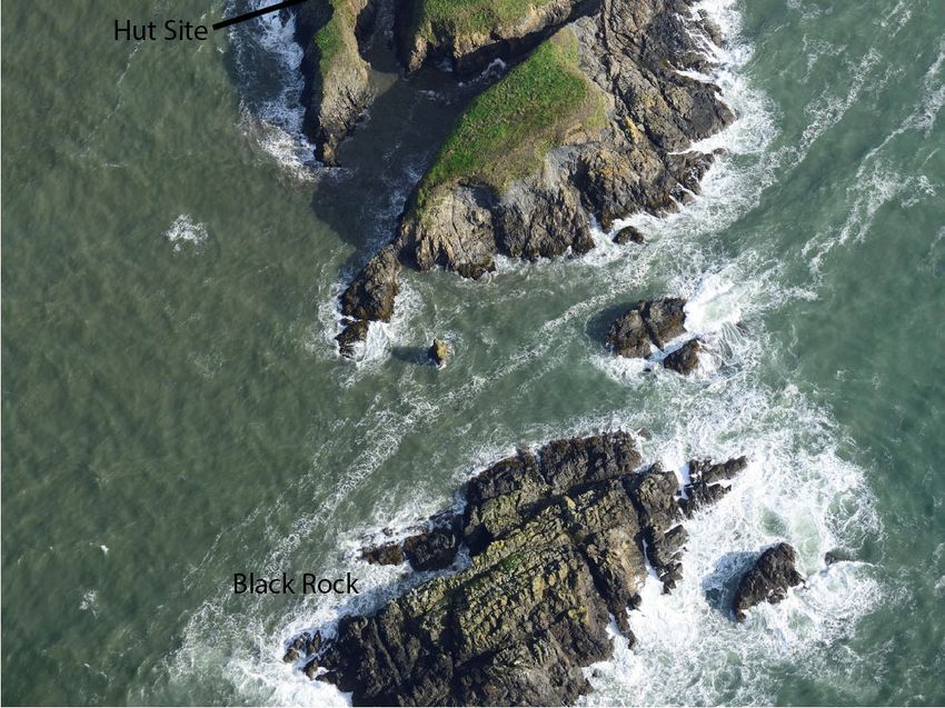
Sustainability 2020, 12, 5794 4 of 21
Sustainability 2020, 12, x FOR PEER REVIEW 4 of 22
used in the 8th to 9th century, with the hut inhabited from the late 9th to 11th centuries AD, though
the banks
the stone rampartandwasditches, features
preceded bythat define aditch
a shallow promontory fort, date
that produced to that period.
a carbon date ofGordon Childe the
approximately
dated Larrybane promontory fort from a glass bangle and combs to pre-9th century [14] (p. 104).
6th century BC [21] (pp. 306–307, 312–316). On Dalkey Island, excavations revealed early medieval
Radiocarbon dating from the base of one of the fosses at Dunbeg indicated that the fort was being
occupation prior to the construction of the promontory fort, within which were amphora, glass and
used in the 8th to 9th century, with the hut inhabited from the late 9th to 11th centuries AD, though
bronze pins
the stone [13] (pp. 165–166).
rampart was preceded Theby presence
a shallow ofditch
FrenchthatEproduced
ware potterya carbonin this
dateassemblage
of approximatelysealed theunder
the bank suggested
6th century the (pp.
BC [21] pre-bank
306–307,deposit to be
312–316). Onfrom postIsland,
Dalkey mid-6th century revealed
excavations AD [22] early(p. 95). The lower
medieval
layersoccupation
of the ditch of the
prior to thepromontory
constructionfort produced
of the promontoryearlyfort,
medieval
within bonewhichpins,
wereand four bone
amphora, glasscylinders
and
common in Viking Dublin. This suggests that the fort was constructed after AD550 and the site was
bronze pins [13] (pp. 165–166). The presence of French E ware pottery in this assemblage sealed under
still inthe
usebank suggested
during the Norsethe pre-bank deposit
settlement to be not
though fromnecessarily
post mid-6th forcentury AD [22]
its original (p. 95). The lower
purpose.
layers of the
Research ditch
into the of coastal
the promontory
promontory fort produced early medieval
fort is significant forbone
severalpins,reasons.
and four bone cylinders
Primarily, from a
common in Viking Dublin. This suggests that the fort was constructed after AD550 and the site was
physical perspective, they protrude into the sea, making them an unmistakable part of the maritime
still in use during the Norse settlement though not necessarily for its original purpose.
landscape and of vital importance to passing seafarers for navigation. Conversely, their occupiers
Research into the coastal promontory fort is significant for several reasons. Primarily, from a
can observe the sea lanes, allowing them to monitor and, to some extent, control traffic, and to take
physical perspective, they protrude into the sea, making them an unmistakable part of the maritime
defensive
landscapeaction
andifofnecessary.
vital importanceThis to maritime functionforofnavigation.
passing seafarers features adds to previous
Conversely, interpretations,
their occupiers can
whereobserve
promontorythe sea lanes, allowing them to monitor and, to some extent, control traffic, and to take It is
forts are considered alongside landward hillforts and defended farmsteads.
also the case that
defensive their
action date of use
if necessary. Thisis maritime
not properlyfunctionunderstood,
of featureswith adds many publications
to previous attributing
interpretations,
themwhereto thepromontory
Bronze Age forts
or are
Ironconsidered
Age. Today, alongside
they arelandward hillforts and
a monument founddefended
on both farmsteads.
sides of theIt is Irish
Sea asalsowell theascase that their
Brittany. Thisdate of use
could beisinterpreted
not properlyasunderstood,
attesting towith many publications
a former linkage of these attributing
areas and
peoples,themif to the Bronze Ageinora Iron
contemporary, Age. Today,
maritime culture.they are a monument
Finally, and of crucial found on both sides
importance from of the
the Irish
practical
Sea as well as Brittany. This could be interpreted as attesting to a former linkage of these areas and
standpoint of the ability to conduct archaeological research, these sites are especially sensitive in their
peoples, if contemporary, in a maritime culture. Finally, and of crucial importance from the practical
environmental context. As a result of their exposed coastal location on clifftops, they are actively being
standpoint of the ability to conduct archaeological research, these sites are especially sensitive in their
eroded by the sea, with increased erosion likely from predicted climate change [23].
environmental context. As a result of their exposed coastal location on clifftops, they are actively
The
beingWaterford
eroded by Copper
the sea, with Coast has a striking
increased complex,
erosion likely with at least
from predicted 26 coastal
climate promontory forts
change [23].
recorded The today in the National
Waterford Copper CoastMonument Record
has a striking (NMR)with
complex, within only2624coastal
at least km between
promontory Tramore
forts and
Dungarvan,
recordedoverlooking the Celtic
today in the National Sea to the
Monument SW (NMR)
Record of Waterford
within only City24(Figures
km between 1 and 2). However,
Tramore and
noneDungarvan,
have been overlooking
excavated, the butCeltic
all haveSea to the SW
been of Waterford
identified fromCity local(Figures 1 and 2).
knowledge, However,
site noneaerial
visits and
have beentoexcavated,
photographs be under but all have
severe been identified
erosional threat. This frompaper
local knowledge,
begins withsite visits and
a broad aerial of
discussion
the historical maritime situation along the Waterford coast. A more detailed examinationtheof the
photographs to be under severe erosional threat. This paper begins with a broad discussion of
historical maritime situation along the Waterford coast. A more detailed examination of the
concentration of promontory forts with the evidence for erosion is then presented with a possible
concentration of promontory forts with the evidence for erosion is then presented with a possible
model of how they used to look based on geology, geomorphology, historical evidence, and local
model of how they used to look based on geology, geomorphology, historical evidence, and local
tradition. ThisThis
tradition. modelmodel suggests
suggests that
thatseveral
several forts
forts were linkedand
were linked andlarger
larger forts
forts andand concentrations
concentrations of of
forts forts
suggest control
suggest of sea
control routes
of sea routes andandlocal
localresources.
resources. TheTherates
ratesofoferosion
erosion deduced
deduced from from examining
examining
missing sections
missing in archaeological
sections in archaeological sites
sitessuggests
suggestshow muchcliff
how much cliffhas
hasbeen
been lost
lost andandhowhow longlong surviving
surviving
sites will last.
sites will last.
Figure 2. The promontory forts along the Copper Coast of Co. Waterford (the CHERISH project).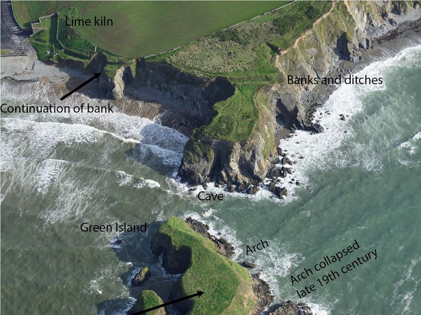
Sustainability 2020, 12, 5794                                                                        5 of 21

2. Materials and Methods
      The information presented has been gathered from desk-based research, field survey and aerial
survey by manned light aircraft and unmanned aerial vehicles (UAVs) conducted between 2017
and 2019 in the context of determining the extent of erosion and the threat to coastal archaeology.
The manned aerial surveys flew from Cork airport on 28th and 29th September 2017 to record the
present state of the coastline for future reference and comparison to any earlier images that can be
found. This was followed by another aerial survey undertaken on 25th October 2017 following 16th
October Storm Ophelia (ex-hurricane Ophelia) to determine whether any damage had occurred to the
forts. This latter survey happened to take place at a lower stage of tide. This identification of wider
archaeological and geomorphological features from the manned aerial survey and archive research
helped to determine the extent of the erosion at sites, the significance of the sites, and what sites should
be prioritised for site-specific survey.
      As this is a long-term study estimating change over a period of 1500–2000 years, and in the absence
of high-accuracy map resources extending back over a century or more, no recourse was had to the
GIS-based Digital Shoreline Analysis System (DSAS) [24]. Even 19th-century mapping covered in the
OS 1st Edition of 1839–1841 lacks precision in the drawing of the coastline, so frustrating accurate
measurement of coastal retreat over a reasonably extensive timescale. Furthermore, this investigation
is a site-specific look at the effects of erosion and not a macro approach where the DSAS would be
more valuable. However, present work incorporated in the CHERISH project will provide the baseline
precision for comparative studies and future return recording at sites will enable the repeat surveys and
the potential to identify specific areas of change. A recent wider-scale UAV survey by the Geological
Survey of Ireland (GSI) will be scrutinised using a landscape approach to erosion.
      All promontory forts along the coast lie in areas of privately owned farmland. Although there
was a coastal path traversing large areas of the Copper Coast marked on earlier OS maps, it has been
seriously eroded to the point of danger in many places. There are fishermen’s paths with access to the
shore from the road from Tramore to Dungarvan, but these are unmarked and only known locally.
Access permission was always obtained from the local farmers concerned prior to field and UAV survey.
The UAV surveys were conducted to determine the extent of archaeological features within the forts
and in the surrounding fields. A DJI Phantom 4 Pro operated through the DJI Ground Station Pro app
was used. The ground on inaccessible islands exhibits a covering of long grass that has not been grazed
for c. 200 years and may obscure features: however, in some cases, banks, hut sites and enclosures
could be determined from a change in vegetation. Further local knowledge of erosion and history was
obtained during these visits. All field surveys were restricted to the tops of cliffs and thence landward
due to the inaccessibility of many bays and coves that lie at the foot of the steeply eroding cliff-line.
      The certainty that the landscape has changed to an extent dependent upon geology and resistance
to erosion allows for some modelling of the late Iron Age and early medieval landscape to properly
interpret its former appearance and likely exploitation. Evidence of erosion can be seen in a variety of
features including scree, sea stacks and arches, tunnels, geos, and the wave-cut platform. The shallow
extent of submerged rock in the wave-cut platform evidences continuations of the land, and can be
seen indirectly through kelp beds that grow on hard substrate, and are visible as shadows on the
breaker zone in the aerial photographs. The bedrock geology, once important for locating mineral
resources for metal working groups that operated on this coast, was obtained from the GSI.
      Additional evidence derives from local or oral tradition as to where sites were once located and
where erosion is occurring. Information can also be found in place names, which record owners of
sites, the resources found at a particular site, or where an event happened. One source, the Irish annals,
were yearly listings of ecclesiastical and secular events recorded by the monastic communities [25]
(p. 49), although it has been argued that this source is only reliable from AD650, postdating most
references in the annals to promontory sites such as Illaunobrick in the study area. Earlier material
comprises a pre-Christian “history” of Ireland and represents an attempt by later annalists to integrate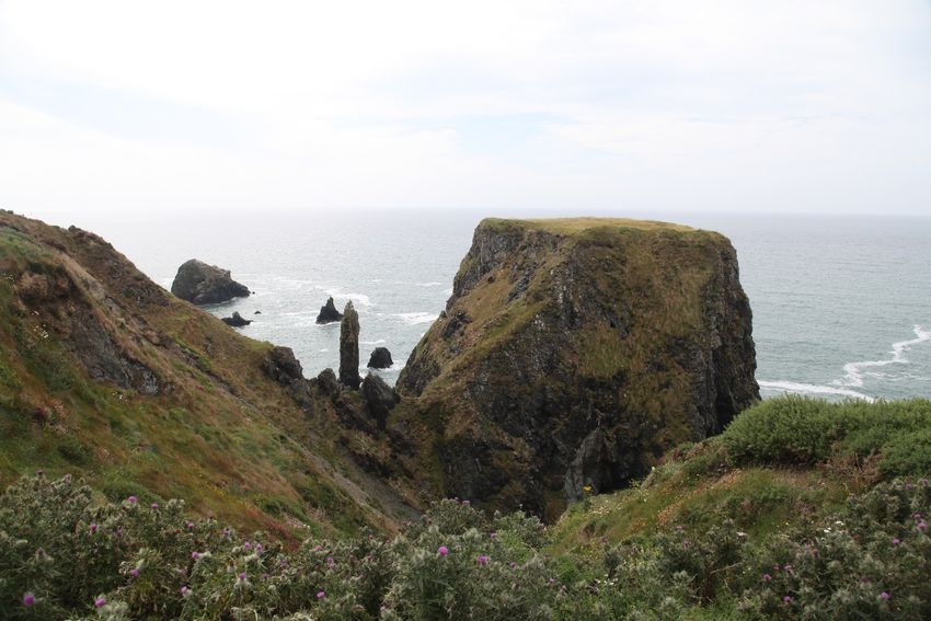
Sustainability 2020, 12, 5794                                                                     6 of 21

Biblical and Classical history with Irish history by combining it with Irish oral traditions, myth and
hereditary King Lists.

3. Results

3.1. Environment
      The Waterford ‘Copper Coast’ lies between Fenor in the east and Stradbally in the west (Figure 2).
Its name alludes to mining that occurred up to the 19th century and which is evidenced by adits in the
cliffs, with shafts, spoil heaps, ore yards and engine houses landward, all located near promontory
forts such as Tankardstown, Templeyvrick and Knockmahon. The rich mineral deposits were mined
extensively from 1824 to 1908 in and around Bunmahon [26] (p. 336). The cliffs are composed of
volcanic and sedimentary rocks from the Ordovician and Devonian periods [27]. The sedimentary
rocks include mudstones, limestone and siltstones exposed at Dunabrattin Head and conglomerates
in Ballydowane Bay and Bunmahon Head [28] (pp. 56, 60), [26] (p. 341). The volcanic features were
formed from two submarine centres formed 450 million years ago. The western centre, called the
Bunmahon Volcano, is composed of andesite, and was followed by the Kilfarrasy volcano, composed
mainly of rhyolite. The sea cliffs, today, are up to 70 m high with occasional small sandy coves and
bays. The spring tidal range of approximately 4 m affects the vertical incidence of marine erosion.
Small rivers outflow into larger bays with sand bars such as the Mahon at Bunmahon and the Anne at
Annestown. With reference to subaerial erosion, the Copper Coast experiences precipitation in the
range of 800–1200 mm/yr, a significant, if low, amount, in an Irish context, while prevailing winds are
south-westerly, impacting strongly on the east–west trending coast particularly in gale conditions [29].

3.2. Historical Background
      A powerful group during the later Iron Age to the early medieval period in southern Co. Waterford
were the Déisi [30] (pp. 147–150). Archaeological evidence of their claimed territory is found on
inscribed ogham stones, which appear in Ireland in the 5th to 6th century. They are found on the
Waterford coast at Ardmore, the townland of Island on the Copper Coast, and on the ancient road
from Ardmore to Lismore to Cashel, where the kings of Munster were based [31]. The Knockmahon
promontory fort, located to the east of Mahon Estuary at Bunmahon, contained two ogham stones,
one of which read as SENAQ MAC (or Q) Q (or C), and it was postulated that Senaq is the same
as Senach, who according to the Annals of Ulster had descendants who were kings of the Déisi in
the 8th century [32] (p. 9). Evidence of religious persuasion lies in place names such as Kilfarrasy
(Church of Fergus) promontory fort, Kilduane (Church of Duane) and Ballydowane (homestead of
Duane). Duane or Dubhán was a 5th-century Welsh saint who set up a monastery on Hook Head, Co.
Wexford. Moreover, the name Templeovrick, used both for a sea stack and the neighbouring townland
(Templeyvrick), is indicative of a church (temple) associated with the name O’Bric. Some evidence that
place names retain their pre-Christian names, and therefore perhaps Iron Age in origin, can be found
in examples like Kilmurrin (church of Muirne), where Muirne was the mother of Fionn mac Cumhaill
in Irish mythology.
      According to the 17th-century historian Geoffrey Keating, the Déisi originally possessed the
district of Déisi Dheisceirt from the River Suir southwards to the sea, and from Lismore to Creadan
Head on western side of Waterford Estuary, up until the 5th century, when the king of Munster gave
them Deise Thuaisceirt from the River Suir to the Plain of Cashel [33] (p. 187). The king of Déisi
Thuaisceirt was O’Phelan, whose residence was on the River Suir to the west of Clonmel called Dun Ui
Faoláin (Fort of O’Phelan). A kinsman of O’Phelan called O’Bric occupied Déisi Dheisceirt, and he had
his stronghold beside the sea at Illaunobrick (Island of O’Bric) (Figure 3). The allegiance of the Déisi
was divided between these two kings [34] (p. 194).
      Along the Copper Coast, there are four promontory forts in the townland of Ballynarrid: two
forts are at Rinnamoe on the western side, the main fort is probably Illaunobrick, also known as Danes
Sustainability 2020, 12, 5794                                                                                       7 of 21

      Sustainability 2020, 12, x FOR PEER REVIEW                                                              7 of 22
Island, and Slippery Island is to the east of the townland. To the west of Ballynarrid in the townland of
      Island, and
Ballydowane       Slippery
                are         Island
                     a further   twoispromontory
                                       to the east of the townland.
                                                      forts:  one on To
                                                                      thethe west ofside
                                                                          western    Ballynarrid  in the townlandCove,
                                                                                          of Cooneennacartan
      of Ballydowane    are a  further  two  promontory     forts: one on the  western  side of Cooneennacartan
and the other immediately landward of Saint John’s Island. To the east of Ballynarrid at Bunmahon
HeadCove,
       in theand  the other
              townland        immediately landward
                          of Templeyvrick      is anotherofpromontory
                                                             Saint John’s fort.
                                                                           Island.
                                                                                TheTocoast
                                                                                       the east
                                                                                           here of  Ballynarrid
                                                                                                 displays  manyatsmall
      Bunmahon Head in the townland of Templeyvrick is another promontory fort. The coast here
islets and stacks including Saint John’s Island, Templeobrick, Shag Island, Gull Island and Illaunwee.
      displays many small islets and stacks including Saint John’s Island, Templeobrick, Shag Island, Gull
TheseIsland
        sevenand
               promontory      forts are bounded by the bays of Bunmahon to the east and Ballydowane to
                  Illaunwee. These seven promontory forts are bounded by the bays of Bunmahon to the
the west   that are  a mere
      east and Ballydowane to2  kmtheapart.
                                      west that are a mere 2 km apart.

      FigureFigure   3. photograph
              3. Aerial Aerial photograph
                                     lookinglooking  west the
                                              west along   along
                                                              coastthe  coast Ballynarrid
                                                                     around    around Ballynarrid
                                                                                          townlandtownland  with
                                                                                                    with Templeyvrick
             Templeyvrick in the foreground  and Ballydowane   in the  distance (CH_2017_0453 taken
      in the foreground and Ballydowane in the distance (CH_2017_0453 taken 28 September 2017).     28 September
              2017).
     A suggestion that the mines recorded around Illaunobrick are from the Bronze Age is refuted by
           A suggestion that the mines recorded around Illaunobrick are from the Bronze Age is refuted
the presence of a drill hole, which would point to the 19th century: (formerly fires would have been lit
      by the presence of a drill hole, which would point to the 19th century: (formerly fires would have
to crack the stone) [35] (p. 23). There is some evidence of external trade from the southern Waterford
      been lit to crack the stone) [35] (p. 23). There is some evidence of external trade from the southern
coastWaterford
       during the   early
                  coast    medieval
                        during        period,
                                the early        with period,
                                           medieval   medieval   imported
                                                              with medievalpottery
                                                                             importedfrom  B ware
                                                                                       pottery from(African
                                                                                                     B ware Red
Slipware tablewares and storage jars/amphorae) and E ware (coarse tablewares from the Loire Valley)
at the Ballygarran ecclesiastical site (approximately 2 km upriver from Tramore Bay), and at Kilgrovan
near Dungarvan [36] (p. 60). A copper ingot weighing approximately 0.5 kg (though only half remains)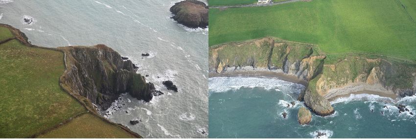
Sustainability 2020, 12, 5794                                                                      8 of 21

and cast in a circular mould was found c. 6 km upstream from the estuary at Bunmahon that is similar
in shape to ingots made in Roman Britain [37] (pp. 88–89); and the National Museum of Ireland
(NMI) topographic files record a wooden oak paddle and bailer found in old mine workings in 1850
approximately 21 m below the surface. As they were ‘apparently of great age’, this suggests that there
was activity in the mines at least beyond living memories of the 19th century.
      There are historical records beginning in Elizabethan times of mines being worked near Bunmahon.
Francis Wyse, in 1748, took a 31-year lease from Lord Ormond for the mineral rights west of
Bunmahon [38] (pp. 10–12). The NMI record an Irish 17th-century trade token found near Knockmahon
Castle (the ‘castle’ may be referring to the promontory fort in this townland), which could have been
associated with earlier mineral trading in this area. Wyse may also have been involved in a partnership
working Lord Ranelagh’s land, possibly near Annestown, in 1745 for copper. The geological memoir
noted that this area was searched for copper but had limited success [39] (p. 56).
      A geologist in 1824 observed that there were earlier mine workings at Illaunobrick: it was,
however, possible to exploit the area for a further 40 years, yielding annually almost half a ton of
pure silver along with approximately 75 tons of lead including veins up to 70 m extending below the
seabed [38] (pp. 11–12). During the 19th century, the Mining Company of Ireland worked copper to the
west and east of Bunmahon [39] (p. 82). During this 18th- to 19th-century period of industrial mining,
the earlier exploited mines were called ‘Danes mines’ or ‘old men’s workings’, indicating that they had
little knowledge of when or who undertook the mining [40] (pp. 3–4). This period is probably when
Illaunobrick became referred to as ‘Danes Island’, by migrants brought in for mining work, evidently
aware that it was an ancient site but attributed its construction wrongly to the Vikings. Mines were
excavated into the cliff, with vertical pits landward, and out to sea at Ballydowane, Illaunobrick and
Templeyvrick for copper, lead and silver [38] (pp. 25, 27) [39] (p. 82).

3.3. Fort Destruction by Erosion
      Table 1 shows the present characteristics of promontory forts along the Copper Coast. Intertidal
erosional features such as stacks, stumps, arches, tunnels, caves and geos surround all sites and allude
to a potential maximum extent when in use (Figures 3–5). Some forts are very narrow (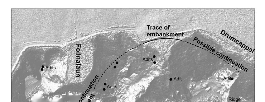
Sustainability 2020, 12, x FOR PEER REVIEW 9 of 22
another
Sustainability arch
2020, 12, lies directly below the hut site on Sheep Island, with further arches through the island
5794 9 of 21
forming after the 1st OS edition (1839–1841).
(a) (b)
Figure 4.Figure 4. (a)
(a) The The narrow
narrow promontoryfort
promontory fort at
at the
theFaill
Faillna na
Smuite in Stradbally
Smuite More sloping
in Stradbally Moredown
sloping down
towards Gull Island (3M6A0475 taken 25 October 2017); (b) Corcoran’s Island promontory fort in
towards Gull Island (3M6A0475 taken 25 October 2017); (b) Corcoran’s Island promontory fort in
Annestown (CH_2017_0381 taken 30 September 2017).
Annestown (CH_2017_0381 taken 30 September 2017).
Table 1. Characteristics of promontory forts, listed from west to east, along the Copper Coast,
Table 1. Characteristics of promontory forts, listed from west to east, along the Copper Coast, combined
combined from historic maps, Geological Survey of Ireland data, aerial survey, fieldwork, and
from historic maps, Geological
references [34,41–43]. Survey of Ireland data, aerial survey, fieldwork, and references [34,41–43].
No.No.
of of
Name Townland Geomorphology Area (ha)Area Height
Height
(m) Geology
Name Townland Geomorphology Banks/
Banks/Ditches Geology
(ha) (m)
Ballyvoyle Head 1 Islandhubbock Headland 0.65 74 Ditches
1 Mudstone and sandstone
Mudstone and
Ballyvoyle Head 2 Head
Ballyvoyle Islandhubbock
1 HeadlandHeadland 0.30
Islandhubbock 0.65 7474 1 1 Mudstone and sandstone
sandstone
Islanhobegg Islandhubbock Promontory 0.27 50 3 Mudstone and sandstone
Mudstone and
Ballyvoyle Head 2 Islandhubbock Headland 0.30 74 1
Shale and siltstone, peperite,
sandstone
Faill na Smuite Stradbally More Promontory 0.01 50 1
Mudstone porphyry
and
Islanhobegg Islandhubbock Promontory 0.27 50 3
Ballyvoony Ballyvoony Promontory 0.04 30 2 Shale and siltstone, peperite
sandstone
Stradbally Shale and siltstone,
Conglomerate, sandstone and
Faill
Ballydowane na Smuite
West Ballydowane West Promontory0.12
Promontory 0.01 4050 1 1
More peperite, porphyrysiltstone
BallydowaneBallyvoony
East 2 Shale and siltstone,
Conglomerate, sandstone and
BallydowaneBallyvoony
East Promontory0.12
Promontory 0.04 4530 2 1
(Saint John’s Island) peperitesiltstone.
Ballydowane East 1 Conglomerate,
Conglomerate, sandstone and
BallydowaneBallydowane
East Promontory 0.10 45 3
Ballydowane
(Cooneennacartan W) West Promontory 0.12 40 1 sandstone and rhyolite
siltstone,
West
Rinnamoe W siltstone
Ballynarrid Headland 0.07 40 2 Rhyolite, slate
Conglomerate,
(Cooneennacartan E)
Ballydowane East 2 Ballydowane
Rinnamoe Promontory 0.12 4045 1 1 sandstone and slate
(Saint EJohn’s Island)
Ballynarrid East Headland 0.06 Rhyolite,
siltstone.
Illaunobrick
Ballynarrid Stack 0.35 47 1 Rhyolite, slate
Conglomerate,
(DanesBallydowane
Island) East 1 Ballydowane
Promontory 0.10 45 3 sandstone and
(Cooneennacartan W)
Templeobrick Ballynarrid East Stack 0.10 c. 20 0 Rhyolite, slate
siltstone, rhyolite
Slippery Island
Rinnamoe W Ballynarrid Promontory 0.16 45 2 Basalt to andesite, shale
Ballynarrid Headland 0.07 40 2 Rhyolite, slate
Joy’s(Cooneennacartan
Island E) Conglomerate, sandstone and
Templeyvrick Headland 0.72 20 1
(Bunmahon Rinnamoe
Head) E Ballynarrid Headland 0.06 40 1 Rhyolite, slatesiltstone
Illaunobrick (Danes
Knockmahon Knockmahon Promontory 0.15 20 1 Basalt, andesite shale
Ballynarrid Stack 0.35 47 1 Rhyolite, slate
Island) Tankardstown
Foilaneena Cashel Stack 0.03 c. 20 0 Shale and siltstone, peperite
Templeobrick Ballynarrid Stack 0.10 c. 20 0 Rhyolite, slate
Drumboe Tankardstown Promontory 0.28 40 2 Shale and siltstone, peperite
Basalt to andesite,
Slippery IslandTankardstown
Drumcappul Ballynarrid Promontory0.16
Promontory 0.16 4045 2 2 Shale and siltstone, peperite
shale
Foilboy Cashel Tankardstown Stack 0.18 c. 20 0 Shale and siltstone, peperite
Conglomerate,
Joy’s Island
Templeyvrick Headland 0.72 20 1 sandstone and clastics and
Calcareous
(Bunmahon Head)
Dunabrattin Dunabrattin Headland 7.50 20 1
siltstone
limestone bands
Knockmahon
Dunabrattin Knockmahon Promontory 0.15 20 1 Basalt, andesite
Calcareousshale
clastics and
Dunabrattin Promontory 0.16 20 2
(subsidiary fort) limestone bands
An Rinn Benvoy Promontory 0.30 20 1 Shale and siltstone, peperite
Corcoran’s Island Annestown Promontory 0.07 20 1 Rhyolite, slate
Woodstown Woodstown Promontory 0.28 20 2 Felsic volcanics
Kilfarrasy Island Kilfarrasy Promontory 1.08 45 1 Felsic volcanics
Islandikane South
Islandikane South Promontory 1.35 30 1 Felsic volcanics
(Sheep’s Island)
Islandikane East Islandikane East Promontory 0.20 25 2 Felsic volcanics
Garrarus 1
Garrarus Promontory 0.24 46 2 Basalt and gabbro
(Illaunacoltia)
Garrarus 2
Garrarus Promontory 0.07 15 3 Felsic volcanics
(Rinn Chaol)
Garrarus 3 Garrarus Promontory 0.02 15 1 Felsic volcanics
Great Island Westtown Promontory 0.99 38 1 Felsic volcanics
Little Island Westtown Promontory 0.10 23 1 Felsic volcanics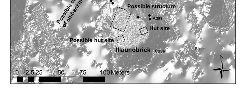
Sustainability 2020, 12, 5794                                                                                        10 of 21

      Similarly, the bank and ditches of the Woodstown promontory are only 50 m from the cliff edge
today but, if the fort is joined to its islands and islets (Green Island and Black Rock), it would make
a promontory potentially up to 370 m in length (Figure 5). The hut site on Green Island that was
identified from UAV data again suggests that this island was joined to the mainland. Green Island was
split into two islands between the 1st (1839–1841) and 2nd (1897–1905) OS editions. Such landscape
change would formerly have provided more shelter to the landing place at Annestown Beach to the
west, and the probability that the beach itself may have been further seaward as well. In the early
20th century, Westropp argued that the extreme narrowness of the southern channel between Green
Island and the Woodstown promontory fort was evidence that it has been cut through by the sea in
recent times, and that a new arch formed through the centre of Green Island was an indication of
further future island creation [41] (pp. 253–254). This east–west orientation of erosion seen in the
island splitting and arch formation is also occurring along the ditch and bank area of the mainland
part of the promontory fort where it has been indented and erosion is particularly noticeable today.
It indicates a weakness in the bedrock in this direction, and forecasts that the future of the fort is to be
dissectedSustainability
            further2020,into12,more
                               x FOR PEER REVIEW
                                     island  segments.                                       11 of 22

                 Aerial
      Figure 5.Figure     photograph
                       5. Aerial        of Woodstown
                                 photograph of Woodstownpromontory    fort
                                                         promontory fort   with
                                                                         with     features
                                                                              features     marked
                                                                                       marked       (CH_2017_0668
                                                                                              (CH_2017_0668
      Table 29. Table 29. September
                 September    2017).2017).

               Westropp [41] (pp. 253–254), in remarking on the severe erosion at Woodstown, referred to the
          defences being eroded for 11 m west of the fort, save for slight mounds of an outer or landward ring
          (Figure 6). The path along the cliff from the lime kiln leading beside the beach to the west of the fort
          has been eroded away in sections. This path can be seen relatively clearly on the 1st-edition OS map
          though parts had started to erode by the 2nd edition. Along this path, approximately 80 m to the west
Sustainability 2020, 12, 5794 11 of 21
Westropp [41] (pp. 253–254), in remarking on the severe erosion at Woodstown, referred to the
defences being eroded for 11 m west of the fort, save for slight mounds of an outer or landward ring
(Figure 6). The path along the cliff from the lime kiln leading beside the beach to the west of the fort
has been eroded away in sections. This path can be seen relatively clearly on the 1st-edition OS map
though parts had started to erode by the 2nd edition. Along this path, approximately 80 m to the west
of the present promontory fort’s eroded banks is a small promontory with a trace of a bank visible
in the aerial and UAV imagery that appears to be part of the continuation of the fort’s embankments
(Figure 5). This gives further indication of how much of the width of the fort has been lost, extending
Westropp’s 11 m to as much as 80 m lost. In an earlier guise, therefore, the fort would have continued
Sustainability 2020, 12, x FOR PEER REVIEW 12 of 22
much closer to Annestown Beach, and would enlarge its potential measurements to 120 m wide by
370 370
m long.
m long. This amounts
This amountstoto4.44
4.44 ha,
ha, though
though ititmay
mayconceivably
conceivably have
have thinned
thinned seaward,
seaward, thus halving
thus halving
the calculated
the calculated area
areabut, even
but, evenso,
so,aafigure
figure exceeding
exceeding 22ha
haisisstill
still much
much larger
larger thanthan the 0.28
the 0.28 ha today.
ha today.
Figure 6. The
Figure banks
6. The and
banks andditches
ditches eroding onthe
eroding on thewestern
westernsideside of Woodstown
of the the Woodstown promontory
promontory fort fort
(CHERISH August 2018).
(CHERISH August 2018).
Around
Around Tankardstown,
Tankardstown,an animportant 19th-centurycopper
important 19th-century copper mining
mining area,
area, therethere is a group
is a group of sitesof sites
situated within
situated 600
within 600mm onontwo
twopromontories
promontories and andtwo
twostacks
stacks (Figure
(Figure 7). 7).
TheThe promontories
promontories Drumboe
Drumboe
and Drumcappal have an enclosure landward that encloses both of them, suggesting
and Drumcappal have an enclosure landward that encloses both of them, suggesting that they were that they were
originally
originally partpart
of of
thethe samepromontory
same promontory fort,
fort, but
butwhich
whichsince has
since been
has eroded
been and and
eroded divided. The stacks
divided. The stacks
are less than 40 m from the present shore. They were originally considered sites byNational
are less than 40 m from the present shore. They were originally considered sites by the the National
Monuments Service (NMS), as they were marked on the early OS maps as Foilboy Castle and
Monuments Service (NMS), as they were marked on the early OS maps as Foilboy Castle and Foilaneena
Foilaneena Cashel, suggesting an oral tradition of a defended site. They were later removed from the
Cashel, suggesting an oral tradition of a defended site. They were later removed from the site list,
site list, as NMS inspection saw no structures present today, perhaps due to erosion. However, the
as NMS
amountinspection saw
of erosion, no structures
closeness present
of the stacks today,
to the cliffs,perhaps
and miningdueintothis
erosion. However,
area could the amount of
have weakened
erosion, closeness of the stacks to the cliffs, and mining in this area could have
the cliffs, leaving only an oral tradition of further promontory forts in this area. The cliffs are weakened the cliffs,
leaving only an oral tradition of further promontory forts in this area. The cliffs
composed of volcanic peperite intruded into shale and siltstone, that forms the steep actively eroding are composed of
volcanic
cliffs peperite
seen on theintruded into shale and siltstone, that forms the steep actively eroding cliffs seen on
aerial image.
the aerialAimage.
fault exists between Foilaneena Cashel and Drumboe promontory fort, which lies 140 m west,
orientated north–south. This may have been an area of weakness making it less likely that they were
part of the same fort. Conversely, the evidence from Annestown indicated that faults can make
stronger features in the landscape. Presently, Drumboe has an area of 0.28 ha (and Drumcappal is
0.16 ha) so, as such, they are relatively small forts. However, as it they are in an area of important
copper resources, a larger fort may have been located here to control the area.Sustainability 2020, 12, 5794 12 of 21
Sustainability 2020, 12, x FOR PEER REVIEW 13 of 22
Figure
Figure Sites around
7. around
7. Sites Tankardstown
Tankardstown (CH_2017_0695
(CH_2017_0695 taken
taken on 29 on 29 2017).
September September 2017).
A fault
In theexists between
Ballynarrid Foilaneena
area, Cashelwith
erosion is severe andthe
Drumboe
promontory promontory fort, which
of Illaunobrick, a seat oflies
the 140
kingsm west,
orientated north–south.
of the Déisi This may
presently being haveasbeen
described an area
a stack with of
onlyweakness making
a ‘goat track’ it less
access likely
(Figure that is
8). This they
in were
partthe areasame
of the of copper, silver and lead
fort. Conversely, mining into
the evidence theAnnestown
from cliffs, whichindicated
has exacerbated the can
that faults erosion.
makeThe stronger
surrounding
features area aroundPresently,
in the landscape. Ballydowane and Bunmahon
Drumboe Baysof
has an area has nine
0.28 hapromontory forts located
(and Drumcappal in aha) so,
is 0.16
section of coast less than 4 km, with seven concentrated in less than 2 km. Some of these
as such, they are relatively small forts. However, as it they are in an area of important copper resources, promontory
forts are presently of limited area on narrow cliffs c. 50 m long and c. 10 m wide, such as two at
a larger fort may have been located here to control the area.
Rinnamoe (Figure 3).
In the Ballynarrid area, erosion is severe with the promontory of Illaunobrick, a seat of the kings of
In Ballydowane townland, it is likely that Saint John’s Island was once joined to the mainland,
the Déisi
but ispresently beingby
now separated described as a stack with40
a chasm approximately only a ‘goat
m-wide track’9).
(Figure access
A low(Figure
circular8).hut
This
siteis3.4
in mthe area
of copper, silver and lead mining into the cliffs, which has exacerbated the erosion.
in diameter close to the western edge of the promontory was found during aerial survey by Casey The surrounding
area[43].
around Ballydowane
As there is a hut siteand Bunmahon
on this stack, thisBays has that
suggests ninethere
promontory
was directforts located
access to thisin a section
islet when the of coast
less than 4 km, with seven concentrated in less than 2 km. Some of these promontory forts are presently
of limited area on narrow cliffs c. 50 m long and c. 10 m wide, such as two at Rinnamoe (Figure 3).Sustainability 2020, 12, x FOR PEER REVIEW 14 of 22
promontory fort was constructed. Vertical cliffs approximately 45 m high surround this area of coast
Sustainability 2020, 12, 5794 13 of 21
and a sea tunnel running east–west through Saint John’s Island called Poulatunish indicates further
erosional features.
Figure 8. Illaunobrick promontory fort showing the eroded access to the site with Templeobrick
Figure 8. Illaunobrick promontory fort showing the eroded access to the site with Templeobrick
amongst the stacks
amongst in the
the stacks background
in the background(CHERISH
(CHERISH 24 July 2019).
24 July 2019).
In Ballydowane
Approximately townland,
100 m to the it iseast
likely that Saint
of Saint John’sJohn’s
Island,Island
still inwas once joined
Ballydowane, to the mainland,
is another narrow but
is now separated by a chasm approximately 40 m-wide (Figure 9). A
promontory fort (Figure 9). This is approximately 55 m long but only 18 m wide narrowing seaward. low circular hut site 3.4 m in
diameter
The fort close
has to the western
a series edgeearthen
of three low of the banks
promontory
and twowas shallowfound during aerial
intervening ditchessurvey by Casey
across the neck [43].
As there
of the is a hut site Having
promontory. on thisthreestack, thisindicates
banks suggests anthat there fort,
important waswhich
directseems
access to this
a very largeislet
numberwhen the
of defences for such a narrow promontory. Therefore, this fort was almost
promontory fort was constructed. Vertical cliffs approximately 45 m high surround this area of coast certainly much larger than
andtoday. This is supported
a sea tunnel by stacks and
running east–west rockySaint
through reefs John’s
to the south.
IslandBetween this fort and Saint
called Poulatunish John’sfurther
indicates
Island is a
erosional features.cliff of Old Red Sandstone call Foilrigeen. The farmer from Ballynarrid, said approximately
40 years ago the neighbouring farmer experienced a cliff fall at Foilrigeen when driving the tractor
Approximately 100 m to the east of Saint John’s Island, still in Ballydowane, is another narrow
around the field. A missing section of clifftop field boundary could still be seen on the 2008 Google
promontory fort (Figure 9). This is approximately 55 m long but only 18 m wide narrowing seaward.
Earth image of this cliff, and where approximately 20 m of field boundary is gone and the indent is
The upforttohas
10 m.a series of three low earthen banks and two shallow intervening ditches across the neck of
the promontory. Having three
The two promontory banks
forts indicates ansite
in Ballydowane important
have their fort, which boundary
landward seems a very large
at the number of
interface
defences
between Old Red Sandstone shales and conglomerates clearly seen in the cliff behind and the volcanic than
for such a narrow promontory. Therefore, this fort was almost certainly much larger
today. This or
andesite is rhyolite
supported that by
formsstacks and rocky reefs
the promontories. Thisto theprobably
was south. aBetween
fault line,this fort of
an area and Saint John’s
weakness
thatishas
Island beenofexploited
a cliff Old Redby nature in the
Sandstone callformation of the
Foilrigeen. Thecliff, but also
farmer from theBallynarrid,
builders of the promontory
said approximately
fort would
40 years ago the have used this weakness
neighbouring farmer to excavate their
experienced ditch.
a cliff fallAsat there has been
Foilrigeen when so much
driving erosion
the tractor
between the two forts, it is very likely that these two forts are actually
around the field. A missing section of clifftop field boundary could still be seen on the 2008 Google originally part of the same
structure with the area between them subsequently eroded. This would explain why the eastern fort
Earth image of this cliff, and where approximately 20 m of field boundary is gone and the indent is up
is so thin and narrow, with little space for a fort defended by three banks. The distance of 100 m
to 10 m.
between the forts is not unreasonable when the 40 m to Saint John’s Island has also been eroded.
The two
Some of thepromontory
eroded material forts in Ballydowane
between site have
these forts may their landward
be discerned boundary
by the bedrock at the
on aerial imagesinterface
between Old Red Sandstone shales and conglomerates clearly
on the foreshore, as this marks where the eroded cliff could originally have reached.seen in the cliff behind and the volcanic
andesite or rhyolite that forms the promontories. This was probably a fault line, an area of weakness
that has been exploited by nature in the formation of the cliff, but also the builders of the promontory
fort would have used this weakness to excavate their ditch. As there has been so much erosion between
the two forts, it is very likely that these two forts are actually originally part of the same structure with
the area between them subsequently eroded. This would explain why the eastern fort is so thin and
narrow, with little space for a fort defended by three banks. The distance of 100 m between the forts
is not unreasonable when the 40 m to Saint John’s Island has also been eroded. Some of the erodedSustainability 2020, 12, 5794 14 of 21
material between these forts may be discerned by the bedrock on aerial images on the foreshore, as this
Sustainability
marks where 2020, 12, x FOR cliff
the eroded PEERcould
REVIEWoriginally have reached. 15 of 22
Figure 9. Saint John’s Island showing the sea tunnel of Poulatunish underneath Saint John’s Island,
Figure 9. Saint John’s Island showing the sea tunnel of Poulatunish underneath Saint John’s Island,
with two
with promontory forts forts
two promontory landward separated
landward by the
separated by Old
the Red
Old Sandstone cliffscliffs
Red Sandstone (CHERISH 3M6A0441
(CHERISH
taken3M6A0441
on 25 October
taken 2017).
on 25 October 2017).
In aInsimilar
a similarmanner,
manner,the thetwo
twonarrow fortsatatRinnamoe
narrow forts Rinnamoe in Ballynarrid
in Ballynarrid could could
have have been connected.
been connected.
The The
distance
distancebetween
betweenthem themisisjust
just 80
80 m, stacks
stacksare arepresent
present between
between them,
them, and and the ditch
the ditch and banks
and banks
could have
could linked
have linkedup upin inthe
the past. They
past. They areare each
each up toup10tom10 m wide
wide and 80and 80 mprotruding
m long, long, protruding
into the into
sea, and
the sea, and aa NMS
NMSvisitvisitinin1989
1989remarked
remarked that it isit an
that unsuitable
is an unsuitable placeplace
for afor promontory
a promontory fort (not
fort (not
envisioning what they could have looked like prior to erosion). It is unlikely
envisioning what they could have looked like prior to erosion). It is unlikely that they were connected that they were connected
to the
to the promontory
promontory forts
forts totothe
thewest
west inin Ballydowane
Ballydowanebecause because thethe
stream flowing
stream into Cooneennacartan
flowing into Cooneennacartan
would always have divided this area and lowered the cliff line. That there were two banks and ditches
would always have divided this area and lowered the cliff line. That there were two banks and ditches
indicates a promontory fort of some significance greater than for fishing access to the shore as it is
indicates a promontory fort of some significance greater than for fishing access to the shore as it is
used today. The field north of the Rinnamoe promontory forts is known as ‘Castle Field’ though there
usedistoday. The field
no evidence for anorth
castle of onthe
theRinnamoe
early maps,promontory
suggesting that fortstheisfeature
knownmust as ‘Castle
be older Field’ though
and that the there
is nopromontories
evidence for a castle
had on the early
more significance in maps,
the past. suggesting that the feature must be older and that the
promontoriesToday,had more significance
Illaunobrick in the past.
stands dramatically when viewed from the mainland, with almost vertical
Today,
cliffs 47 mIllaunobrick stands dramatically
high and a table-top summit 70 bywhen 50 m in viewed
area onlyfrom the mainland,
connected today bywith almost vertical
an impassable
steep-sided isthmus 65 m wide. The adit mining in the
cliffs 47 m high and a table-top summit 70 by 50 m in area only connected today by an cliffs around Illaunobrick, theimpassable
next
promontory fort to the east, has contributed to erosion by weakening
steep-sided isthmus 65 m wide. The adit mining in the cliffs around Illaunobrick, the next promontory the structure of the cliffs
fort (Figures 8 and
to the east, has10). This has been
contributed followed
to erosion byby large-scalethe
weakening collapse,
structure perhaps
of themaking a significant
cliffs (Figures 8 and 10).
difference in the shape of the coastline since the promontory was occupied. Two adits have
This has been followed by large-scale collapse, perhaps making a significant difference in the shape of
previously been identified by local historian Des Cowman on the NW side of Illaunobrick that
the coastline since the promontory was occupied. Two adits have previously been identified by local
continued on the mainland at the SE side of the small promontory at Foilnalaun [35] (p. 25). These
historian Des Cowman
were identified on theadits
as Wyse’s NW in side of Illaunobrick
a report by a mining thatconsultant
continuedHenry on thePricemainland
in 1824attothe SE side
the
of the small promontory at Foilnalaun [35] (p. 25). These were identified
Hibernian Mining Company that described a copper vein c. 14 m to the east of Illaunobrick. Cowman as Wyse’s adits in a report by
a mining consultant Henry Price in 1824 to the Hibernian Mining Company
determined the land between these adits had eroded away if they were exploited as the single copper that described a copper
veinvein
c. 14described
m to theineastthe of Illaunobrick. Cowman determined the land between these adits had eroded
report.
away if theyFurther
wereerosion is described
exploited as thewith
singlea rock fall invein
copper the winter
describedof 1980–1981, revealing another copper
in the report.
vein on the
Further east side
erosion of the isthmus
is described withwithin
a rock14fallm of in an
theopening
winter on the west siderevealing
of 1980–1981, of Illaunobrick
another[35]copper
vein on the east side of the isthmus within 14 m of an opening on the west side of Illaunobrick [35]Sustainability
Sustainability2020,
2020,12,
12,x 5794
FOR PEER REVIEW 1615ofof2221
(pp. 22, 25). On the NE side of Illaunobrick, two adits were buried by a rock fall c. 1973. This reveals
(pp.
the 22, of
level 25). On the
erosion NE the
since side18th
of Illaunobrick, two adits
and 19th centuries, were
which buried
has by a rock fallby
been exacerbated c. mining
1973. This reveals
for which
the level of erosion since the 18th and 19th centuries, which has been exacerbated by mining
purpose 13 adits are known in the cliffs (Figure 10). Today, the cliff collapse can be seen from scree for which
purpose
around the13isthmus,
adits arewhile
known in the
a cove oncliffs
the SE(Figure 10).
side of theToday,
stack the cliff collapse
indicates that notcan
all be seen from
erosion scree
has been
around the isthmus,
caused by mining. while a cove on the SE side of the stack indicates that not all erosion has been
caused by mining.
Figure 10. Digital Terrain Model of Illaunobrick from unmanned aerial vehicle data showing mines
and promontory fort features (the CHERISH project).
Figure 10. Digital Terrain Model of Illaunobrick from unmanned aerial vehicle data showing mines
and promontory fort features (the CHERISH project).
The 1st OS edition (1839–1841) marks a ‘site of entrenchment’ on the landward side of Illaunobrick,
suggesting that there was local knowledge of banks and ditches here which had eroded by 1840. Today,
The 1st OS edition (1839–1841) marks a ‘site of entrenchment’ on the landward side of
a trace of a bank exists for 60 m in the overgrown ungrazed land on the seaward side of the farm wall
Illaunobrick, suggesting that there was local knowledge of banks and ditches here which had eroded
opposite the stack. This disappears on both termini into steep cliff coves with scree probably from
by 1840. Today, a trace of a bank exists for 60 m in the overgrown ungrazed land on the seaward side
mining and cliff collapse. It is likely that the promontory fort builders used the weakness in the rock to
of the farm wall opposite the stack. This disappears on both termini into steep cliff coves with scree
build their ditch and pile up the bank beside it. The erosion along the line of the defences parallels
probably from mining and cliff collapse. It is likely that the promontory fort builders used the
events at Woodstown. The ditches and banks appear more susceptible and have consequently endured
weakness in the rock to build their ditch and pile up the bank beside it. The erosion along the line of
more erosion than other parts of the promontory to form the stack today. Mineral veins in joints in
the defences parallels events at Woodstown. The ditches and banks appear more susceptible and
the rock were exploited by miners, further encouraging erosion. Thus, it might be surmised that the
have consequently endured more erosion than other parts of the promontory to form the stack today.
entrenchment crossed the presently eroded area between Foilnalaun and Illaunobrick, which has now
Mineral veins in joints in the rock were exploited by miners, further encouraging erosion. Thus, it
collapsed apart from the narrow isthmus seen today.
might be surmised that the entrenchment crossed the presently eroded area between Foilnalaun and
There is possible further evidence of a once more substantial mainland connection in the translation
Illaunobrick, which has now collapsed apart from the narrow isthmus seen today.
of the Irish name Foilnalaun as ‘cliff of the island’. The term ‘island’ is common along the Copper
There is possible further evidence of a once more substantial mainland connection in the
Coast, frequently on other promontory forts which are not actual islands, for example being found in
translation of the Irish name Foilnalaun as ‘cliff of the island’. The term ‘island’ is common along the
the place names Islandhubbock, Joy’s Island, Slippery island and even in the townland called Island,
Copper Coast, frequently on other promontory forts which are not actual islands, for example being
where the most noticeable feature is a landward circular ecclesiastical enclosure. The term ‘island’ may
found in the place names Islandhubbock, Joy’s Island, Slippery island and even in the townland
thus be a reference to a more subconscious separation of forts and enclosures by building ditches and
called Island, where the most noticeable feature is a landward circular ecclesiastical enclosure. The
banks to mark an area different from the ‘land’.
term ‘island’ may thus be a reference to a more subconscious separation of forts and enclosures by
building ditches and banks to mark an area different from the ‘land’.You can also read