MAIDSTONE CENTRE CONSERVATION AREA APPRAISAL & MANAGEMENT PLAN APPENDIX - Maidstone Borough ...
←
→
Page content transcription
If your browser does not render page correctly, please read the page content below
Maidstone Centre Conservation Area                                                   Historical Development

                     MAIDSTONE CENTRE CONSERVATION AREA
                    APPRAISAL & MANAGEMENT PLAN APPENDIX
                             Historical Development
This document should be read in conjunction with the Maidstone Centre Conservation Area
Appraisal and Management Plan, adopted 18 January 2021.

EARLY HISTORY

The earliest documentary evidence for settlement first appears in Saxon charters of c. 975 where it is
named either as “de maides stana” or as “maegdan stane”, probably meaning either “the maiden’s
stone” or “the people’s stone” – possibly a megalithic tomb which was used as a meeting place. By
1086 the Domesday Book entry is for “Meddestane”, and in 1159 the town is known as Maidestan.
The first recorded use of the current spelling is in 1610.

The origins of settlement in Maidstone are not fully understood and there has been little systematic
archaeological investigation carried out in the town. Much of what is known has depended on
chance finds, many of them in the 18th, 19th or early 20th Century, which were either never properly
recorded or which did not benefit from the application of modern archaeological techniques.

First evidence for human activity in the Maidstone area dates from the Mesolithic period (c. 9000 –
4000 BC) and indicates the presence of nomadic hunter-gatherers. The area was obviously attractive
to early settlers of the Neolithic period, as evidenced by surviving ritual monuments such as Kits Coty
House and the other Medway Megaliths found to the north and west of the town. Works in advance
of the construction of the Channel Tunnel Rail Link brought to light the existence of a Neolithic
house at Bluebell Hill, not far away from Kits Coty House to the north of the town. A Bronze Age
beaker was found at Tovil in 1892, some distance southwest of the Conservation Area, and post
holes tentatively ascribed to the Bronze Age were found during archaeological investigations on the
Palace site just to the south of the Conservation Area.

Late Iron Age activity in the general area is evidenced by large cremation cemeteries at Aylesford
and Allington, and cremation urns and pottery of similar date have been discovered as chance finds
in numerous locations in central Maidstone. In the years immediately preceding the Roman Invasion
the oppidum (or proto-town) at Quarry Wood, Boughton Monchelsea, was established, and it is
possible that some settlement focus may have occurred within its territory at the future site of
Maidstone.

The Maidstone area is rich in remains of the Roman period, but there is no concrete evidence of
there being a town here. Evidence from elsewhere, however, does suggest that it was common
practice for settlement focussed on oppida to shift under Roman influence to more lowland sites
served by rivers. There are two known Roman villas in the immediate vicinity of the town centre –
one at The Mount just to the north of the Maidstone East railway line, and another southeast of the
Conservation Area on the eastern side of Upper Stone Street. Many other villas are known along
this stretch of the Medway Valley. Two large cremation cemeteries of Romano-British date were
discovered during building operations during the 18th and 19th centuries. One was at the junction of
Earl Street and Pudding Lane, where several urns containing ashes and other human remains were
found in 1715 about which little is known – possibly associated with this cemetery were the two or
more Romano-British urns found in St. Faith Street circa 1850 and the Romano-British burial group
found in Havock Lane in 1932, as well as the 8 skeletons excavated to the rear of nos. 40-50 Earl
Street in 2003 as part of the archaeological investigations carried out prior to construction of the

                                                                                                       1
Maidstone Centre Conservation Area                                                   Historical Development

Fremlin Walk development. These archaeological investigations also found various pits and ditch
features dating from the Roman period as well as contemporary pottery. The existence of this
extensive cemetery (together with another one found in 1859-60 at Westborough, across the
Medway, which yielded 25-30 skeletons and about 150 pottery or glass urns) suggests some form of
reasonably substantial settlement – if such a settlement did exist, the cemeteries, in accordance
with Roman law, would have been outside it.
Other finds of the Roman period include a 2nd Century jar found during the construction of Len
House in Mill Street in 1937 and a possibly Romano-British building found during the construction of
Colman House at the junction of Week Street and King Street in 1967.

Week Street/Gabriel’s Hill/Stone Street mark the line of the known Roman road linking Rochester
with the iron-rich Weald and the coast near Hastings (and by another road diverging from it at Chart
Sutton to the Roman port at Lympne (Portus Lemanis). It has been suggested that the name of
Week Street is derived from the Latin word “vicus”, a term often applied to small Roman towns –
although it should be noted that the direct derivation is from the medieval manor of Wyke, whose
manor house stood close to the present-day junction of Week Street and Union Street. It has also
been put forward that the “ston” element in various Kentish place names (i.e. the “stone” in
Maidstone) – such as, for example, Folkstone, Lullingstone, Cuxton, Keston and Teston – is often
indicative of Roman building in the vicinity, although as in many of these examples this may be
related to substantial villas rather than towns or villages. In another example, however, at Stone-by-
Faversham, there is conclusive evidence of a Roman religious building being incorporated into a
Christian church by the 8th Century and laying close to the probable site of the small Roman town of
Durolevum.

If a small town did exist at Maidstone in Roman times there are two possible reasons for its
existence. The ragstone deposits in the area are known to have been exploited in Roman times and
the product was used extensively in London to which it could have been easily shipped from
Maidstone via the Medway and the Thames. It is possible that one or both of the villas in the vicinity
were associated with the quarrying industry rather than agriculture (the villa off Stone Street not
being that far away from the later Coombe Quarry). A small town could well have grown up to
house workers and provide services for them, and to act as a port for shipping the stone, perhaps
based around the confluence of the Medway and the Len.

The other possible impetus for the development of a small town may have been connected with
facilities provided for the benefit of the cursus publicus or Imperial Post – the official Imperial
messenger service. These included inns for overnight accommodation (“mansiones”) and posting
stations where horses could be changed (“mutationes”) and known examples of both types of
establishment have given rise to town development elsewhere. Written evidence from the Roman
period exists to show that the development of an inn was considered to be a profitable sideline for a
villa estate lying close to a main road, so it is possible that one of the Maidstone villas may have
been tempted to set up one. Perhaps, however, a posting station is more likely, given the proximity
of the major Roman town at Rochester which is more than likely to have possessed at least one inn.
Research on Stone Street, the London-Chichester Roman road, has found that posting stations were
spaced approximately 11-13 miles apart – a spacing which tallies quite well with the distance from
Rochester to Maidstone.

Given the known location of the Romano-British cemetery in the area to the north of the present
High Street, the focus of any Roman town which did exist is possibly most likely to be found in the
Len Valley, possibly around Wrens Cross (at the extreme southern end of the Conservation Area) or
in the area around the church/palace complex which became the focus of activity in the Saxon
period. However, small Roman towns were not always so regularly laid out as larger ones, and

                                                                                                       2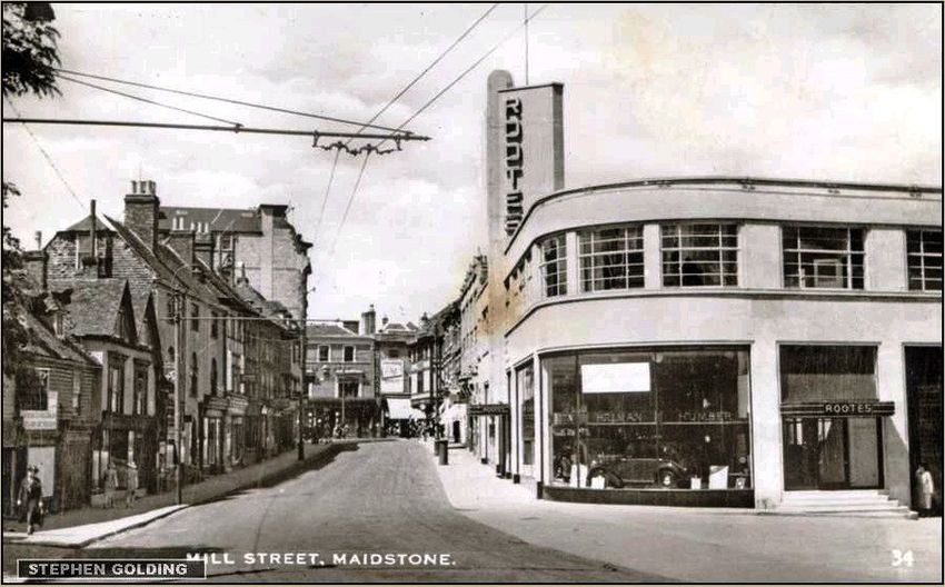
Maidstone Centre Conservation Area                                                     Historical Development

ribbon development was common. Such development along the Rochester-Hastings road may have
occurred and could account for the remains found at the Colman House site.

Evidence of Anglo-Saxon activity in the area is rather more sparse but this is likely to be the result of
the more fugitive nature of any archaeological remains. An Anglo-Saxon cemetery was located in
the area around the junction of Wheeler Street and Brewer Street to the north-east of the
Conservation Area – several inhumation burials with weapons and jewellery dated circa 590-620
were found here in the 19th Century, so the implication is that there must have been some degree of
settlement in the vicinity.

It is likely that land around Maidstone formed a royal estate by this time. The centre of this was
probably just to the south of the Conservation Area, around the area now occupied by the later
medieval complex of All Saints’ Church and the Archbishop’s Palace which is now included in the
separate All Saints’ Conservation Area. All Saints’ Church occupies the site of the earlier St. Mary’s
Church, an important pre-Conquest minster church. The date of foundation of St. Mary’s Church is
not definitely known, but in the Domesday Monachorum (which is roughly contemporary with
Domesday Book but reflects pre-Conquest arrangements) it is recorded as being “mother church” to
17 “daughter churches”. All 15 recorded pre-Conquest minsters in Kent were associated with
ancient royal estates or estates granted by the crown to the church at a very early period. It has
been noted that the original “mother churches” of Kent were often founded in the 7th Century (e.g.
St. Mary’s Reculver, founded on royal land with the old Roman fort in 633). A settlement of lay
people, necessary to serve the needs of the minster, may have formed the nucleus of Saxon
Maidstone, grouped around the church, manor house and the adjacent river crossing to its south. If
nothing else, it was during the Saxon period that Maidstone acquired its present name.

MEDIEVAL MAIDSTONE

In the Domesday Book of 1086, the Archbishop of Canterbury held the manor of Maidstone which
had 25 tenant farmers, 21 smallholders and 10 slaves and was worth £35 10s (as opposed to £14
immediately pre-Conquest). There were 5 mills, 2 eel fisheries and a church. There were also four
sub-manors held by tenants owing military service (32 tenant farmers and 10 smallholders in total).
The entries suggest an entirely agricultural community with no indication of urban characteristics,
although a Sunday market was being held at St. Mary’s Church by the 11th Century (and which
survived until the 15th Century).

However, by 1200 Maidstone was a recognisable town, but its focus had shifted away from the
church/manor complex to the higher land on the north side of the River Len. The 12th Century was a
time of intense town formation throughout Western Europe as monarchs, barons and churchmen
sought to cultivate the profits of urban property and markets. Between 1066 and 1190 about 100
new towns were created in England and Wales and one of the characteristic features of such places
is often a planned gridded street pattern such as exists within the Conservation Area where the old
Roman road was used to form an eastern base-line with main streets developed off it to the west
(High Street, Earl Street and St. Faith’s Street) linked by lesser cross streets (Pudding Lane, Havock
Lane and Market Street, the last two now lost beneath the Fremlin Walk development). The
impetus behind the foundation of the “new” town was the Archbishop of Canterbury as Lord of the
Manor, although the precise date is not known. The creation of a separate court for the people of
the town (as distinct from the manorial court) indicates a formal act of foundation by the
Archbishop, but unfortunately no record survives of the date of this creation.

It is possible that the High Street, which was laid out to a typically broad plan and acted as the
market place, had been developed by the late 11th/early 12th Century. The market itself was more

                                                                                                         3
Maidstone Centre Conservation Area Historical Development
than likely founded before the mid 12th Century as after this date it could only have been established
by Royal grant (the first extant charter for a market in Maidstone dates from 1261 but seems to
relate to land associated with the hospital at Newark, of which St. Peter’s church survives, on the
opposite bank of the Medway). The grid plan to the north was probably complete by 1200 – its
northern edge probably marked by the second medieval church of St. Faith, a dedication often found
attached to churches at the entrances to towns. The present church is a Victorian re-build but the
original church is likely to have been founded prior to 1200 as it possessed burial rights, which were
jealously preserved by mother churches such as All Saints’ after that date. It may also be relevant
that the first documentary evidence of an archbishop’s palace in Maidstone dates from 1207/08 –
the movement of the focus of the settlement away from the old manor house/church complex and
separated from it by the River Len may have produced a degree of seclusion conducive to the
upgrading of the manor house to a palace for the archbishop’s use and revenues from the “new”
town may have helped to finance it. That commerce had developed is indicated by the surviving
record of a shop being sold in 1248.
Extract from map of Maidstone 1650 based on a written description by Nicholas Wall.
The medieval planned layout remained fully legible in this period.
The streets of the “new” town and of Week Street and Gabriel’s Hill were set out with typical long,
thin burgage plots with narrow street frontages (to maximise the number of properties). In many
places these are still identifiable today, particularly in High Street/Bank Street, Gabriel’s Hill and
Week Street, and still exert an influence on the physical form, grain and scale of the Conservation
Area.
By the early 14th Century it has been estimated that the population of the town had reached about
2000 (about one third of the size of Canterbury at that time). Various occupations for townspeople
are recorded between 1273 and 1479, of which tailors, shoemakers, skinners/tanners, barbers and
4Maidstone Centre Conservation Area Historical Development
masons are particularly notable. Other occupations listed include clothmakers, dyers, smiths,
carpenters, wax chandlers, butchers, bakers, mercers, vintners, spicers and glovers. This range of
tradesmen suggests a thriving town catering for many of the needs of its inhabitants and of the
surrounding rural hinterland. Archaeological evidence from the north end of Week Street, just
beyond the Conservation Area, adds pottery production to the list of trades operating in the town at
this period. The wool trade was also important at this time, and after 1331 when Edward III invited
the Flemish clothworker John Kemp to England, where he settled in Cranbrook, the Wealden cloth
trade began to develop. Fullers Earth, essential to the cloth-making process, was worked at Boxley
and was used locally in fulling mills which developed along the River Len and the Loose Stream. It
was also exported via the Medway and added to the importance of the port function of the town.
Ragstone was probably still being transported via the river as it had been in Roman times. It is
probable that the first bridge over the Medway from the bottom of the High Street was built
sometime during the 14th Century, replacing the old crossing near All Saints’ Church.
In 1331 the Franciscan Order
embarked upon a project to
build a friary in the town,
which suggests that the town
must have been considered
to be large enough and
prosperous enough to
support it. Two houses and 6
acres of ground were given
to the Order as a site for the
friary, which was reputedly
founded by Edward III and his
brother the Earl of Cornwall.
The location of the friary has
never been firmly
established. There is a long
tradition that it was sited at
the junction of Gabriel’s Hill
North-east part of Corpus Christi Hall and neighbouring buildings on Earl Street.
and King Street, and indeed
this location is marked on 19th
Century Ordnance Survey maps as the site of a priory. It has also been suggested that the medieval
stone cellars which still exist beneath the later building at this location are the physical remains of
the friary. However, this siting seems unlikely for a number of reasons. Firstly, then as now, this
must have been a prime commercial location; secondly, the surviving pattern of burgage plots shows
no sign that there has been any aggregation of plots to form a piece of land large enough to support
a sizeable establishment such as a friary; and thirdly, the topography, with land falling away steeply
to the Len Valley, does not lend itself to a complex of large buildings. Furthermore, typical locations
for friaries are either immediately outside of town limits or on undeveloped land just inside them –
often land unattractive for development for one reason or another – e.g. liability to flooding. They
also tend to occupy large precincts with space for large graveyards. The existence of the medieval
cellars is also not persuasive – such cellars are relatively common in medieval towns, and at least
two other examples survive within Maidstone. Possibly a more likely site is that now known as
Corpus Christi Hall. The Guild of Corpus Christi was set up in the town in the early 15th Century, and
in 1422 was given a pre-existing hall at the lower end of Earl Street – could this have been the
remains of the friary which appears to have failed? Many of the friars were transferred to
Walsingham Friary in Norfolk when it was founded in 1345. The site seems much more likely for a
friary, being in a peripheral location away from the main commercial centre of the town, in an area
5Maidstone Centre Conservation Area Historical Development
possibly left free of previous development because of its liability to flooding from the nearby
Medway. The fact that the land was originally given to the friars by a certain John atte Water may
suggest a man with a connection to the river.
The Black Death of the 1340s probably affected Maidstone in much the same way as the rest of the
country and it is estimated that the population may have fallen to around 1,700 by 1350.
The establishment of the Corpus Christi Guild by 1422, however, probably indicates a recovery and
prosperity. It is likely to have been founded by leading townsmen to consolidate their positions as
community leaders and to help settle town affairs. Although it supported religious observances and
had a chapel on site as well as its own chantry chapel in All Saints’ Church, it was largely a secular
organisation, fostering trade in the town and dominating religious and cultural life. It also made
provision for the old and infirm, with three almshouses in Pudding Lane and six more on the south
side of the bridge. The 100-200 members of the Guild subscribed annually, the amount depending
on their status, but about half its income came from rents on properties it owned in and around the
town. The hall was the most important business centre in medieval Maidstone, and the complex
also included a chapel, refectory, three cloisters and a garden.
By the 15th Century, business connections were extending their contacts geographically – for
instance the tanning industry had strong links with London.
By 1446 it is known that Middle Row had been developed, infilling the central market space of the
High Street. Gabriel’s Hill and Wren’s Cross are also first recorded by their modern names during the
15th Century, and a deed from 1485 names Pudding Lane. A further religious building, the chapel of
St. John, had been built before 1457 on the east side of the road at the foot of Gabriel’s Hill,
probably associated with the crossing over the River Len. Such chapels were common in the
medieval period and provided a place for travellers to pray for a safe journey (one still exists at
Rochester); it probably marked the southern extent of the main commercial centre of the town.
TUDOR DEVELOPMENT
The 16th Century was a period of significant change in Maidstone as it was for the country as a
whole. Not least amongst these were changes consequent upon the political and religious reforms
of Henry VIII – the Archiepiscopal Manor was surrendered to the Crown and the Fraternity of Corpus
Christi dissolved in 1547. The 16th Century has often been seen as a period of urban decay and a
number of statutes were passed in the 1530s and 1540s aimed at reversing this decay which
described “decayed houses, desolate and vacant ground, pits and cellars left uncovered and many
houses feeble and likely to fall down.” Maidstone may have fared better than some other towns as
John Leland described it in the 1540s as “a market town of one long street well builded and full of
inns.” In one other respect, however, it did reflect conditions in other towns – most towns by the
early 16th Century had suffered a decline in population and sometimes were smaller than they had
been in the Middle Ages – Maidstone’s population in 1548 has been estimated as being probably
between 1,900 and 2,000, no higher than it had been two centuries previously.
Before 1534, the town was administered by the Burghmote, headed by the portreeve assisted by
twelve brethren, who governed on behalf of the Archbishop of Canterbury. This possibly Saxon
arrangement was found to be “insufficient in law” in 1534, and the first Municipal Charter was
granted in 1549. One of the first acts of the new corporation was to found a grammar school which
was housed in the Corpus Christi Hall (where it remained until 1871).
A second charter granted by Elizabeth I in 1559 gave the corporation added responsibilities to
maintain the banks of the Medway and ensure its navigability. The importance of Maidstone as a
6Maidstone Centre Conservation Area Historical Development
port was increasing at this time, and in the 1560s a new stone wall was built at Fairmeadow by the
corporation, presumably to act as a quay. Exports via the river included stone, grain and cloth, much
of these goods going to London. Timber was also shipped to Chatham Dockyard and cannon from
the Wealden ironworks to London, Chatham and abroad. Consumer goods were imported.
In 1566, according to figures quoted by Hasted in the late 18th Century, there were 294 inhabited
houses in the town. By this time the town was supplied by water brought in conduits from a
reservoir at Rocky Hill on the opposite side of the Medway. The Great Conduit terminated at a lead
cistern housed in an octagonal stone tower near the Star Inn in the High Street. There were also
“four landing places, five hoys and ships and 22 persons wholly occupied in the trade of
merchandise” in 1566.
From the mid 1560s onwards, towns all over Kent began to show signs of growth, often due to
migration from the countryside. Maidstone certainly experienced such growth, but also actively
sought immigrants from abroad. In 1567 the town petitioned the Crown asking for 60 refugee
Walloon families from the Netherlands to be sent to the town. In doing so, it sought specific skills in
clothmaking, pot-making, tile-making and paper-making of these immigrants. These religious
refugees were granted their own church (St. Faith). They can be seen as catalysts for the rise of local
industries, some of which, such as paper making, remained of long importance, although the
Walloon population itself had largely dispersed by the 1630s. The population of Maidstone by the
end of the 16th Century was probably about 2,900-3,000.
It may be during the 16th Century that Maidstone began to gain on Canterbury as the primary urban
centre of Kent. There is some evidence that Canterbury suffered a population decline, being
particularly hard hit by the dissolution of the monasteries and the loss of the pilgrim trade, although
the “extreme poverty, nakedness and decay” described by Lambarde in the 1570s may be something
of an exaggeration, and Canterbury too benefited from Walloon immigration. By the end of the
century, Canterbury was probably still nearly twice the size of Maidstone by population.
Urban growth during the 16th Century was not all good news for Maidstone. Epidemics of disease
appear to have caused exceptional levels of mortality in the mid 1540s, in 1563/4, 1578 and 1592-
1597. There was also the problem of vagrants, beggars and squatters who were attracted to the
town. In 1596, Maidstone magistrates lamented that “the number of poor people inhabiting within
this town (by means of the long time of scarcity and dearth…) is now grown and come to be so very
great…that the lamentable cries and miserable estate and condition of the said poor people do
require rapid and speedy relief.” Maidstone, in common with other towns, took measures to try and
keep out poor migrants, the streets being patrolled by the town’s jurats.
The markets at Maidstone remained important during the 16th Century, with the Corn Cross being
located at the top of the High Street and the markets of dairy produce, animals and fruit being held
in the Lower High Street near the junction with Mill Street. In 1599 the first documentary mention
of Earl Street (as Earl’s Lane) occurs. It seems that by the late 16th Century Lower Stone Street had
acquired a high status residential character as it is known that Robert Balsar, twice the Chief
Magistrate of the Borough, was living at number 34 at this time.
SEVENTEENTH & EIGHTEENTH CENTURIES
This sector of the town continued to grow in importance as a location for the town houses of the
gentry in the early 17th Century – in the mid 1600s, Stone House was being lived in by Lady Sackville.
Elsewhere in the town centre there were a growing number of specialist shops. Inns also became
important trading centres and often had associated warehousing facilities and provided
7Maidstone Centre Conservation Area Historical Development
accommodation for assemblies, balls, meetings, etc. In 1610, six inns and 24 alehouses were listed
in the town. Many of these would have originated in medieval times – probably The Ship, The Bull
Inn and The George Inn in Gabriel’s Hill; the Chequers on the corner of Gabriel’s Hill and the High
Street; The Swan, The Star and The Hart in the Upper High Street; and The Queen’s Arms in the
Lower High Street. The Rose and Crown in the Lower High Street is also first documented in 1608.
The most important inn, however, in the early 17th Century was The Star in the High Street which
had a complex of rooms, stables and yards stretching all the way back to Earl Street. It also had a
justice chamber where the County JPs met during the sessions and assizes for political debate,
Maidstone having become the sessions town for West Kent by the late 16th Century and an assize
town from the 1620s. A court house had been built at the top of the High Street by the late 16th
Century which was replaced by a new building in 1608; the County Gaol and the West Kent House of
Correction stood nearby.
These judicial functions were indicative of the increasing importance of Maidstone as an
administrative centre, and by 1650 Richard Kilburne could say that it was “accounted the shire
town…the fittest place for public meetings of the County.”
Maidstone’s importance as a trading centre was also growing. In the early 17th Century it was
described as the “principal market town in the county” and the 1640s John Taylor wrote that it was
“a fair, sweet, pleasant, rich and populous market town”. The whole length of the High Street had
already been occupied by various markets by the mid 16th Century. By the early 17th Century,
however, cloth sales had been lost to London (because of a Parliamentary decision). Conversely, the
grain market had increased in importance, being second only to Gravesend in the county, and having
strong links to London traders. The corn market moved from Corn Cross to the arcaded ground floor
of the 1608 Court House, the fish market from the lower end of Middle Row to the Old Corn Cross,
and the vegetable market to the old fish market site. The lower end of Middle Row also provided
the home for the butter market, housed in a small, round building. Fruit and hop markets were
introduced, and in 1682 Maidstone was granted the right to hold a monthly cattle market which
took place in Earl’s Lane, which was renamed Bullock Lane as a result.
Industry continued to grow and diversify in the 17th Century. By the early 17th Century the cloth
trade sparked by the Dutch immigrants of the 1560s had been adopted by native townsmen
producing “woollen cloth, fustians, linsey-woolsey and diaper”. However, by the 1630s the cloth
industry was in decline, suffering from competition from London.
It was another textile industry introduced by the Dutch which flourished and became the major
industry of Maidstone by 1622 – thread making. By 1640 Maidstone was the main thread-making
centre in England after London, particularly linen thread made from flax. The flax was grown locally
– Samuel Pepys saw “an old man beating flax” on 24th March 1669. Thread-making was labour
intensive and supposedly employed 8,000 people in Maidstone in 1664, although this sounds rather
a generous estimate as the total population of the town by mid century was probably still only about
4,000.
Another trade seemingly introduced by the Dutch, papermaking, also continued to grow. The
availability of clear spring water enabled the production of high quality white paper, and the river
port facilitated the import of rags from London also needed for its production, and also the export
back of the finished product. Seven paper mills were in operation in the vicinity between 1671 and
1700. Turkey Mill to the east of the town centre existed by 1681 when George Gill was described in
the Parish Registers as a paper maker of that address. Like many other paper mills it had been
converted from old fulling mills redundant in the wake of the decline in the cloth trade.
8Maidstone Centre Conservation Area Historical Development
Fullers earth, however, continued to be worked at Boxley and Leeds and remained an important
export by river. In 1640, a Mrs. Brewer of Boxley had three warehouses at Waterside for storing it.
River trade in general expanded greatly in the 17th Century, particularly important commodities
being canons, canon balls, timber, corn, stone, hay, hops, wool and leather. A town charter of 1619
enabled the corporation to charge tolls on all vessels berthing at Maidstone, and Acts of Parliament
in 1628 and 1644 sought to improve the navigation of the Medway by way of locks, towpaths and
dredging.
Another industry to emerge in the mid 17th Century was brewing, the first brewery to open being the
Lower Brewery in Lower Stone Street which comprised a “brewhouse, two malthouses, barns and
stables” as well as an adjacent house. This brewery survived until 1930 – its land is now occupied by
Granada House and the old Granada Cinema. Distilling also arrived, a property on the east side of
Stone Street being sold in 1648 to Daniel Beckman, described as a distiller.
Alongside these commercial
and industrial elements, the
town did not neglect to
provide for recreational
opportunity. A bowling green
was laid out on the King’s
Meadow in 1642, and in 1699
a tree-lined and railed Public
Walk was laid out at
Fairmeadow – one of the
earliest public “parks” outside
London.
By the end of the 17th
Century, rate books show
there to have been 490
householders paying the poor
rate, with the highest
The chimney of the Lower Brewery can be seen in the background of this old
photograph of the bottom of Gabriel’s Hill.
populations being in High
Street (110 houses) and Stone
Street (100 houses). There were also 60 houses in Week Street, 33 in East Lane (King Street), 25 in
Gabriel’s Hill, 13 in Mill Lane (Mill Street), 13 in Bullock Lane (Earl Street), 11 in Middle Row and 7 in
Pudding Lane. By the 1690s, Celia Fiennes could describe Maidstone as “…a very neate market
town…its buildings are mostly of timber worke, the streets are large the Market Cross runs down the
street a good way, there being three divisions in it one good Cross for fruite another for corne and
another for all sorts of things. 2 of which is built over for the town hall and publick use: there is also
a large Gaol: this street notwithstanding the hall and cross stands in the midst, is yet a good breadth
on each side and when it comes to meete in one is very broad and runs down a great length, quite to
the bridge across the Medway which…beares Barges that bring up burdens to the town…there are
very pretty houses about the town look like the habitations of rich men…there are severall pretty
streetes.”
The 18th Century was to be something of a heyday for Maidstone, the time when it truly began to be
regarded as the County Town. Much rebuilding and new building took place, a large amount of
which survives within the Conservation Area to help define its character today. In the 1720s, Daniel
Defoe described Maidstone as “a considerable town, very populous and the inhabitants generally
wealthy.” He also considered it to be the best market in the county. In 1739 the Medway
9Maidstone Centre Conservation Area Historical Development
Navigation Company was set up to deal with improvements to the river, which resulted in making
the Medway navigable by barges of up to 40 tons displacement as far as Tonbridge, which boosted
Maidstone’s trade as a trans-shipment centre to the extent that by the late 18th Century the whole
of the Weald and much of Sussex received their groceries via Maidstone. Dr. Pococke, writing in the
mid 18th Century, could state that Maidstone was “a town of considerable trade on account of its
navigation together with good shops.”
In fact, by the late 1780s, Maidstone’s shops were being assessed as being on a par with Canterbury,
Rochester/Chatham and Greenwich as the best in Kent. They were mainly concentrated in High
Street, Week Street and Gabriel’s Hill. By this time, retailing was considered one of the most
important occupations within the town, with grocers being particularly numerous. A 1794 trade
directory for Maidstone lists 22 grocers plus stationers, ironmongers, tobacconists, silversmiths,
linen-drapers, brandy merchants and china sellers amongst the shops then in existence. The late
18th Century also saw the foundation of two private banks in the town – Brenchley, Stacey, Parker,
Springate and Penfold (The Kentish Bank) in premises at the top of Bank Street (and presumably
giving the street its name) in 1793, and the Maidstone County Bank.
In terms of industry, the late 18th Century saw the decline of the yarn spinning/threadmaking trades
which lost out to competition from the new factories of Northern England. Some businesses,
however, continued by making matting and hop bagging using locally produced thread.
Brewing expanded to become a major employer, with Robert Heathorn opening a brewery in the
late 18th Century at the bottom of Earl Street. This was largely engaged in the production of pale ale,
much of it destined for export to India – there may be a link with the cavalry barracks which opened
to the north of the town in the 1790s which was often used by troops en route to India. By the
1780s there were also some 52 inns in the town.
Distilling also continued as a
noticeable industry – Maidstone
was well-known in the 18th Century
for the production of a blackcurrant
liqueur know as gazle wine. Then in
1789 George Bishop built a “large
brick building with yards and other
premises” on the south side of Bank
Street to produce gin, and
“Maidstone Hollands” soon gained a
countrywide reputation for quality.
The 18th Century also saw barge
building added to the riverside
trades. By the latter part of the 18th
Century the old market
arrangements in the High Street were causing The Town Hall of 1764 showing the now infilled ground floor
arcade which originally provided covered space for market traders
traffic congestion, and a new market hall for
fish and vegetables was erected on the site of
the old County Gaol in 1780. The old Court House nearby was replaced by the current Town Hall in
1764, which originally retained an open arcaded ground floor for market traders reflecting the
previous arrangements.
10Maidstone Centre Conservation Area Historical Development
In the early 17th Century, Maidstone had been known as a leading Puritan centre. Its tradition for
religious radicalism was strengthened during the 18th Century with the growth of non-conformism.
A Unitarian church was built in Market Buildings (Mitre Yard) in 1736 and survives to this day, and a
Congregationalist church was built in Week Street in 1747. In 1794 Hasted estimated that nearly
half the population was nonconformist.
Town improvements continued in the 18th Century, both in terms of cultural facilities (a New Theatre
opening in the lower High Street in 1770, succeeded in 1798 by another one further up the street)
and in terms of comfort – following complaints in 1791 the streets of the town were re-paved in
Kentish rag and York stone in 1792 and street lighting was introduced. Notwithstanding this, John
Byng in the 1790s could still describe Maidstone as “a large, ill-built old town”.
The late 18th Century saw the first threats emerge to the predominance of the river for transport.
Turnpike improvements to the roads to Cranbrook, Wrotham and Tonbridge made the routes into
the Weald and towards London easier, and by the 1790s Maidstone was served by 17 coaches a
week to London.
By 1794, Hasted could estimate the population of the town at about 6,000, with 1,500 houses, with
the town being about a mile in length on its north-south axis and three-quarters of a mile across
from east to west – not substantially bigger in area than the medieval town. This was to change
radically within a few years.
VICTORIAN MAIDSTONE
In the first national census of 1801, Maidstone had a population of 8,027. By 1831 this had doubled
to 16,000 and Maidstone had become the largest and most important town in Kent, surpassing
Canterbury. This expansion occurred outside the boundaries of the Conservation Area, but
significant changes took place within it as the town modernised and adapted itself to its new more
dominant role.
The medieval bridge at the foot of the High Street was widened in 1808 to ease traffic congestion at
the sole river crossing into the town. In 1819 a town wharf was built to enhance the
loading/unloading facilities for river craft, but the opening of the Thames and Medway Canal from
Strood to Gravesend in 1824, which shortened the route to London considerably, was the harbinger
of a change of fortune for the town. Initially it worked to Maidstone’s advantage, but the fact that it
avoided the open sea meant that by 1828 the 40 ton barges which could navigate the river up to
Tonbridge were able to cover the whole journey to London and Maidstone’s function as a trans-
shipment centre weakened, resulting in a decline in the wholesaling trade. However, proper sea-
going vessels were using Maidstone by this time and in 1822 a 130 ton schooner was bringing in coal
from the north of England and exporting various goods back and to France and Holland. In 1834
there were 50-60 vessels belonging to the town employed in exporting hops, corn, fruit, paper,
timber and stone. Coal, groceries and other consumer goods were imported. Also in 1819 some
street widening was carried out within the town, drains were laid and the water supply improved by
the use of iron pipes serving 17 public conduits. This was followed in 1822 by 196 gas-lit lamps being
installed to serve public areas, supplied by gas from the gasworks across the river in St. Peters Street
which opened in 1819.
In 1824 it was decided to concentrate the corn, fish, meat and vegetable markets into the same
place and remove them from the streets. The old Mitre Inn and adjoining premises in the High
Street were bought up and a new market hall, together with a replacement Mitre Inn, were built in
1826. These new premises also included grand new offices for the Kent Insurance Offices (which
11Maidstone Centre Conservation Area Historical Development
had opened on this site in 1803) and which still remain as one of the most impressive buildings on
the High Street, designed by John Whichcord Senior, the noted local architect. To the rear of these
new buildings accommodation was also provided for the company’s fire engine which had previously
been housed in All Saints’ Churchyard and then in an engine house near the bridge. The market
itself was gas-lit but was not a great success, being described as “cold and dark” by contemporaries.
It was soon replaced, in 1835, by the present Corn Exchange which had a covered market on the
ground floor. The Corn Exchange itself was, at the time of its erection, the largest in Kent.
The livestock markets were also banned from the streets in 1824, moving first to Penenden Heath
and Fairmeadow and eventually to Lockmeadow on the west bank of the Medway in 1879. “A
Historical Descriptive Account of Maidstone and its Environs” published in 1834 stated that “the
shops in every respect rival those of the capital and supply the inhabitant with almost every article
which luxury can demand.”
By 1839, when J. Smith published the “Topography of Maidstone and its Environs and Directory” the
length of the town from north to south was “estimated to be about one mile and a quarter, and its
breadth about three quarters of a mile. The principle streets and places adjacent are well paved,
drained and lighted with gas; and abundantly supplied with excellent water conveyed by pipes from
Rocky Hill….” This Directory shows that by this time Maidstone town centre contained some 435
shops, of which 105 were in Week Street and 84 in High Street/Bank Street. A further 50 premises
were in Gabriel’s Hill/Lower Stone Street and 21 more were in Earl Street. Within Week Street the
most numerous types of shop were grocers (10), butchers (9), tailors (6), boot and shoemakers (6),
linen drapers (5), bakers (5), druggists (4) and booksellers (4). In High Street/Bank Street butchers
were also important (6 shops), as were grocers (5), boot and shoemakers (4), bakers (4), corn dealers
(4) and linen drapers (4). The most numerous type of outlet in Gabriel’s Hill/Lower Stone Street
were tailors (6 shops), followed by grocers (5), butchers (4) and bakers (3).
By 1851, when the population had grown to 20,740, the number of shops had increased slightly to
475, and by 1872 there were 700 shops and the first indications of the arrival of national or regional
chain stores – for example, George Mence Smith at 20 High Street, a London paint and varnish
maker. Not long afterwards there are indications of the development of proto-department stores,
with Frank King and Sons having three adjacent shops in Lower Stone Street selling clothing, hosiery,
millinery, ladies’ clothes and footwear, with further premises in Gabriel’s Hill selling groceries and
provisions. By 1882 Denniss Paine and Co occupied five shops in the corner of High Street and
Pudding Lane selling millinery, drapery, boots and shoes and ladies’ and men’s clothes, with another
tailoring and outfitting unit operating from two shops at the top of the High Street and an
ironmongery department in a shop adjacent to the Queens Hotel in the lower High Street.
Steven’s Directory of Maidstone for 1882 describes Maidstone as being “…a well-built town, having
some fine business streets, the principal of which intersect each other in the centre of the place.” It
goes on to say that “Maidstone is…important as a trading and commercial town, and although the
nobility and gentry are not so numerous as other towns of similar size, its productive nature and its
commercial trade and exports make it more free from real poor than many other towns of equal
population.” The remarks about the nobility and gentry reflect the fact that by the mid 19th Century
Maidstone had lost out to London as the gathering place for County society, which had resulted in a
decline in status of Lower Stone Street. By this time, the medieval bridge over the Medway had
been demolished and replaced by the existing structure designed by the famous engineer Sir Joseph
Bazalgette and erected in 1877-79.
In 1889 the town received a boost to its status when it was chosen as the headquarters of the newly-
formed Kent County Council. As far as the town’s own administration arrangements were
12Maidstone Centre Conservation Area Historical Development
concerned, the Kent Messenger Directory of Maidstone and Surrounding Villages for 1898 laments
that the “…Town Hall, erected in 1763, is a miserable specimen of the poverty-stricken architecture
of those days, possessing no room adequate to the needs of a large town, and necessitating the
scattering of the offices of the Corporation.” This same Directory also illustrates the continuing
influx of national chain stores – e.g. Singer Sewing Machines (Gabriel’s Hill), Freeman Hardy and
Willis shoes (High Street), Liptons (Week Street), Maypole Dairies (Week Street), Home and Colonial
Stores (Week Street) and London and Provincial Meat Stores (Week Street). It also shows that Earl
Street had by then acquired its present character with shops at the top end and offices at the lower,
where solicitors’ offices were particularly prevalent. The National Telephone Company also had
offices and a public call facility here.
Apart from the new bridge over the Medway, various other improvements to transportation,
improving the accessibility of the town, took place during the 19th Century. In 1815 the road
towards Ashford was improved, giving a more direct route out of the town centre via East Lane
(renamed King Street) without diverting northwards to Penenden Heath. In the 1830s there were
nine coaches a day to London plus services to the Medway towns and other Kent towns. The
existence of public transportation on a more local scale is suggested by the listing of an omnibus
proprietor in the High Street in the 1839 Directory. The same Directory also advertised The Balloon,
a fast stagecoach leaving the
Queens Head in the lower High
Street every day except Sunday at
9.00 in the morning and taking 3 ½
hours for the journey to the
George Inn in Southwark.
At this time, the Town Council and
Lord Marsham of Mote Park were
actively opposing the construction
of a railway line to serve the town,
although proposals were mooted
for a station at the top end of Bank
Street. This opposition resulted in
the building of the South Eastern
Railway Company’s line far to the The Post Office building erected in the High Street in 1871 was one of the
south of the town. This line earliest buildings to introduce a new, larger scale to the town centre (late C19
image).
boosted the fortunes of rival towns
such as Tonbridge and Ashford and it was soon realised that the commercial attractiveness of
Maidstone was threatened by the lack of a rail connection. Pressure then mounted for a rail link to
be built, resulting in the construction of the Medway Valley Branch from Paddock Wood to
Maidstone West station, just across the bridge from the bottom of the High Street, which was
opened in 1844. This line was extended to Strood in 1856. Whilst this later extension improved
accessibility to London it was still not a particularly direct route. This was finally provided by the line
to Maidstone East at the north end of Week Street, opened in 1874 and extended to Ashford in
1884. It has to be said that the resistance to the original proposals to bring a railway right into the
heart of town prevented very significant losses to historic fabric and character.
On the industrial front the gin distillery off Bank Street closed down in 1820 and was converted to a
steam-powered corn mill. With the virtual demise of the cloth trade most local fulling mills
converted back to corn milling in the 19th Century or went over to papermaking; Springfield Mill, to
the north of the town centre, was built by William Balston in 1806 and was the first paper mill to be
driven by steam. One of the last remaining textile firms to survive was J. Clifford and Sons of Bank
13Maidstone Centre Conservation Area Historical Development
Street who specialised in the production of hop-bagging in the early 19th Century and diversified into
coir matting from the 1850s (and in the First World War produced camouflage based on hop
screening and in the Second World War made coconut matting for temporary landing strips).
In 1861, Ralph Fremlin bought the old Heathorn Brewery in Earl Street and built a new brewery
complex in 1871 (but retained the early 19th Century brewer’s house).
The 19th Century also saw the growth of an engineering industry, often based around agricultural
machinery and building components – e.g. William Weeks and Son who had premises and a foundry
at High Street and Waterside. A large tannery was established in Mill Street adjacent to the mill
pond.
In 1851 the Theatre Royal in the High Street was demolished. A new concert hall was built as an
extension to the Corn Exchange by the Town Council in 1865 (and survives as the Hazlitt Theatre). At
the same time the market beneath the Corn Exchange was converted to provide small shops.
Until the 19th Century, redevelopments kept to the scale of the medieval town, both in terms of
overall height and the width of plot frontages. The incursion of larger-scaled buildings began with
the Kent Insurance Office of 1827 which whilst only a little higher than its neighbours occupied a
much wider frontage and introduced a grander scale of architecture than had previously existed.
Most other 19th Century re-buildings still respected the scale of the medieval town, but some
isolated examples such as the Post Office building in the lower High Street also introduced a larger
scale which was to become much more common in the 20th Century.
TWENTIETH CENTURY
By 1901 the population of Maidstone had increased to 33,516. The shopping centre
appears to have continued along much the same lines as previously, but with the introduction of yet
further chain stores – by 1910 these included Hepworths Tailors (High Street), Scotch Wool (Week
Street) and Boots the Chemist (Week Street) in addition to those existing in 1898. New uses to cater
for new technology had also arrived, with a motor garage opening in Earl Street and Allcorn and Co’s
ironmongers at 30-32 Lower Stone Street expanding to cater for cyclists and motor car repairs.
Other retailers were building larger and more impressive buildings, such as the outfitters G. H.
Leavey Ltd. which redeveloped its premises on the corner of High Street and Mill Street in 1906 or
the shops at 16/17 High Street (1907) and 6 and 7 Middle Row (1901). Banks also started to become
more numerous and be housed in more impressive buildings – foremost amongst these was the
Edwardian baroque of the London County and Westminster Bank at 3 High Street, but the neo-Tudor
of the London Provincial Bank of circa 1905 at 10 Middle Row is also notable. Denniss Paine and Co.
rebuilt its premises on the corner of High Street and Pudding Lane after a fire in 1911.
The years between 1900 and the First World War also saw some substantial changes to streets in
Maidstone, largely engendered by the creation of electric tram services. The Borough Council had
built an electricity station in Fairmeadow in 1900 which provided for street lighting in the town
centre. The first tram route was opened to Barming in 1904, but routes proposed to serve Loose
and Tovil were initially held up because Gabriel’s Hill was too steep. The solution was to widen Mill
Street and create an entirely new street (Palace Avenue) to link it to Lower Stone Street. The whole
of the eastern side of Mill Street was demolished. So was the large 3-storeyed weatherboarded mill
building spanning the Len, together with a 3-storeyed double-jettied building of probably 16th
Century date adjacent to it on the west side of the street, around which the street formerly kinked.
Palace Avenue was laid out through mainly open land (formerly a nursery), but a smaller corn mill on
the south side of the mill pond and about four properties in Lower Stone Street were also
demolished. It was utilised to provide a space for a new police station, for the Maidstone Borough
14Maidstone Centre Conservation Area Historical Development
Police Force, built in 1908 to replace former premises in King Street. The Loose and Tovil tram
routes were opened in 1907 and 1909 respectively.
The foundation and growth of Maidstone and District Motor Service also increased the catchment
area of the town centre shops, giving further encouragement to the influx of national chain stores
and redevelopment to provide shops with larger floorspace. The company was founded in 1908 and
operated a route from Maidstone to Chatham with four second-hand buses. By 1913 there were
seven routes, and eleven by 1914.
The original bus garage was
across the river in St. Peter Street,
but it was superseded by one in
Upper Stone Street until finally
moving to Knightrider Street in
the 1920s, where Knightrider
House formed the company
offices. This site was vacated by
the company in the 1980s. A bus
station was also built in Palace
Avenue, opposite the Mill Pond,
in 1922 and is thought to have
been the first bus station in the
country – the site is now a car
park. A further bus station was
opened later in the century at the
junction of Palace Avenue and Lower Stone
Mill Street prior to widening to accommodate tram lines.
Street on the site now occupied by Gail
House.
The growth of motorcar ownership also made the town more accessible but brought with it the
familiar problems of congestion, particularly as the town centre formed the crossing point of two
major routes – the A20 London to Folkestone and Dover trunk road running through High Street and
King Street, and the A229 Rochester to Hastings road running along Week Street/Gabriel’s
Hill/Lower Stone Street. In 1926 the Medway bridge was widened, and one-way traffic systems were
introduced in the late 1920s. Allied to these, a new street was built diagonally between Earl Street
and St. Faith Street (Museum Street) but this has now been subsumed beneath the Fremlin Walk
development. A bypass was discussed in the 1930s but never progressed because of World War
Two. Week Street and Gabriel’s Hill/Lower Stone Street became earmarked for road widening and
widening lines were drawn up. New buildings erected between the 1930s and the 1970s, when the
widening proposals were formally abandoned, were set back to the widening line, leading to the
somewhat serrated frontages now apparent in Week Street and Gabriel’s Hill.
By 1926 the further chain stores attracted by this increased accessibility included W. H. Smith and
Son (High Street), MacFisheries (High Street), Woolworths (Week Street, but not on its later site),
Halfords Cycles (Week Street) David Greig (Week Street) and Marks and Spencer (Week Street). Just
outside the Conservation Area to the north, for adjoining shops were occupied by Dunning and Son,
Drapers. In 1931, Dunning and Son redeveloped the property to form a large department store
(which later became Army and Navy). In 1930, meanwhile, Denniss Paine and Co had been taken
over by Chiesmans to form the other major department store of the town.
The 1920s and 1930s probably marks the time when Week Street started to gain ascendance over
High Street as the primary shopping street. New chain stores arrived – Burtons in purpose-built
15Maidstone Centre Conservation Area Historical Development
premises in Week Street in 1927, Timothy Whites, again in purpose-built premises, also in Week
Street, in 1934. In the later 1930s both Marks and Spencer and Woolworths erected their current
large stores in Week Street. Any such changes in the High Street were restricted to its upper end
near the Week Street junction, with Barratts Shoes at 97 and Lyons Café at 96 having arrived before
1937.
In terms of industrial development in the earlier part of the 20th Century, the most important was
the takeover of the old tannery site in Mill Street by William Rootes in 1917 and its conversion to the
Len Engineering Works, first used for repairing aero engines and then for building charabancs.
Rootes developed into major motor wholesalers and the country’s largest motor retailer. However
in 1928 the head office was moved to London and manufacturing in Mill Street ceased, leaving just a
distribution and service centre. However, towards the end of the 1930s the Mill Street premises
were redeveloped with the large and impressive state-of-the-art showrooms and workshops which
remain as such an important
feature of the Conservation
Area today.
In the brewing industry,
Fremlins bought Isherwood,
Foster and Stacey in 1929 and
closed the latter’s Lower
Brewery in Lower Stone Street,
selling the site for
redevelopment. It was
replaced by the Granada
Cinema in 1934 and Granada
House, a development of shops
with residential flats above, in
1937. The former Rootes showrooms in Mill Street erected in the late
1930s (image 1950s)
The Granada Cinema was, in fact, the last of
the cinemas in the town centre to open. The first permanent cinema in Maidstone was the Empire
Electric, opened in a converted shop in Station Road in 1910. This was succeeded by the New
Empire Electric Cinema, opened in a purpose-built building in 1911 in Earl Street. It is unfortunate
that this early cinema closed in 1957 and was demolished. The Maidstone Pavilion Skating Rink was
opened in the Edwardian period but was converted to a cinema known as the Popular Picture
Pavilion in 1911 – it later became the Ritz Cinema, but was burnt down in 1954 and the site
redeveloped as offices. The Central Cinema opened in King Street in 1920.
For live stage shows, the concert hall attached to the Corn Exchange was supplemented in 1908 by
the Palace Theatre Music Hall opened in Gabriel’s Hill in 1908.
Maidstone did not escape from physical harm in the Second World War. Of greatest consequence to
the character of the Conservation Area was bomb damage in Mill Street which resulted in the
destruction of a number of historic buildings on the west side of the road.
The post-war years saw the trend for larger shops and more national chain stores continue, with
Littlewoods opening a department store in Week Street on the site of the old Central Commercial
Hotel by 1949. There was a continued drift of some of the more important outlets to Week Street,
and by 1958 about half the outlets there were occupied by branches of national chain stores. The
first supermarket in Maidstone came with Victor Value at the north end of Week Street in 1954
16You can also read