Technical Report on the Parkin Offset Joint Venture (POJV) Project Located near Sudbury, Ontario
←
→
Page content transcription
If your browser does not render page correctly, please read the page content below
Technical Report on the
         Parkin Offset Joint Venture (POJV) Project
                Located near Sudbury, Ontario
Including the Milnet, Parkin, CBA Parkin, and Parkin East Properties

                                                         Prepared for:
                                  Wallbridge Mining Company Limited

                                                          Prepared by:
                                                  Joshua Bailey, P.Geo.

                                    Effective Date: December 31, 2013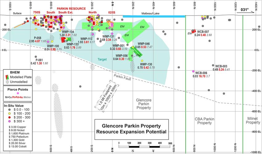
TABLE OF CONTENTS
Table of Contents .................................................................................................................................................................... 2
List of Tables ........................................................................................................................................................................... 3
List of Figures .......................................................................................................................................................................... 3
1. Executive Summary ............................................................................................................................................................. 4
2. Introduction ........................................................................................................................................................................ 9
3. Reliance on Other Experts................................................................................................................................................... 9
4. Property Description and Location ................................................................................................................................... 11
5. Accessibility, Climate, Local Resources, Infrastructure and Physiography ....................................................................... 16
6. History ............................................................................................................................................................................... 17
7. Geological Setting and Mineralization .............................................................................................................................. 17
8. Deposit Types .................................................................................................................................................................... 23
9. Exploration ........................................................................................................................................................................ 26
10. Drilling ............................................................................................................................................................................. 37
11. Sample Preparation, Analyses, and Security................................................................................................................... 42
12. Data Verification ............................................................................................................................................................. 43
13. Mineral Processing and Metallurgical Testing ................................................................................................................ 44
14. Mineral Resource Estimates ........................................................................................................................................... 44
15. Mineral Reserve Estimation ............................................................................................................................................ 45
23. Adjacent Properties ........................................................................................................................................................ 46
24. Other Relevant Data and Information ............................................................................................................................ 46
25. Interpretation and Conclusions ...................................................................................................................................... 47
26. Recommendations .......................................................................................................................................................... 51
27. References ...................................................................................................................................................................... 52
Signature Page ...................................................................................................................................................................... 54
Certificate of Qualified Persons ............................................................................................................................................ 55

                                                                                                                                                                        Page 2 of 55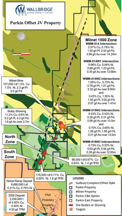
LIST OF TABLES
Table 1. Summary of Claims, Leases and Patents ....................................................................................................................................14
Table 2. Significant Intersections within the Parkin Resource. .........................................................................................................21
Table 3. Significant intersections below the Parkin Resource. ..........................................................................................................22
Table 4. Recent discoveries in Sudbury with greater than 1 million ounces of PGEs. ..............................................................23
Table 5. Significant Intersections from Northbridge 1952-3 Drilling. ............................................................................................31
Table 6. Results of Falconbridge Chip Samples (Parkin Property)..................................................................................................32
Table 7. 1999 Parkin Surface Sample Assays. ..........................................................................................................................................33
Table 8: Summary of Significant Drill Intersections by Champion Bear. ......................................................................................36
Table 9. Summary of Wallbridge drill holes on the Property. ............................................................................................................38
Table 10: Mineral Resources On The Parkin Property – WGM Estimate ......................................................................................45
Table 11. Reserves and Resources estimates at the adjacent Podolsky Project (Farrow et al., 2009). .............................46
Table 12. Two phase recommended work program...............................................................................................................................51

LIST OF FIGURES
Figure 1. The Parkin Offset Joint Venture Project....................................................................................................................................10
Figure 2. Sudbury Igneous Complex and Offset Dykes (Ames and Farrow, 2007). ...................................................................18
Figure 3. Geology and Mineralisation of the Parkin Offset dyke. .....................................................................................................20
Figure 4 . Long section section of the Copper Cliff Offset dyke (Farrow and Lightfoot, 2002). ............................................25
Figure 5. Long Section of the Victoria deposit (Frayne, 2013). ..........................................................................................................25
Figure 6. Northwest facing longitudinal section of the Parkin Offset dyke on the Glencore Parkin and CBA Parkin
(South Block) properties. The near surface Parkin Resource is shown (red polygon) as well as drill hole dyke pierce
points and the trace of the Parkin Fault. EM plates and un-modelled EM responses are shown and significant
mineralized intersections are labelled. ........................................................................................................................................................49

                                                                                                                                                                             Page 3 of 55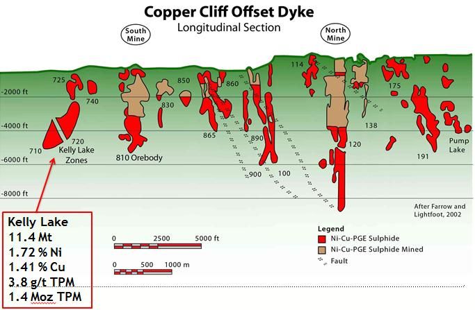
1. EXECUTIVE SUMMARY
Introduction
The Parkin Offset properties (the “Property”) are located in the Sudbury Mining District, in the northeast corner of
the Sudbury structure near Sudbury, Ontario.

The Property is being explored for platinum group metals, copper, nickel and gold by the Parkin Offset Joint
Venture between Wallbridge Mining Company Limited (“Wallbridge”) and Impala Platinum Holdings Limited.

This report was prepared for Wallbridge to summarize the results of exploration on the Property to December
31st, 2013, and to make recommendations for further work.

Property Description and Location
The Property includes four land packages in Parkin and Norman Townships within the City of Greater Sudbury,
Ontario, Canada:

   •       Wallbridge's Milnet property;
   •       Wallbridge's Glencore Parkin property;
   •       Wallbridge's CBA Parkin properties; and
   •       Wallbridge’s Parkin East property.

As of the effective date, these included 49 mining claims, 12 mining leases and 4 patents covering 2,280.83
hectares.

Geological Setting and Mineralization
The Property is underlain by 9.5 kilometres of the Parkin Offset dyke on the northeast corner of the Sudbury basin.
The Parkin quartz diorite offset dyke is sub-vertical, or dips very steeply to the east, and has a width of 45 to 135
m. South of the Milnet mine the dyke strikes 033°. At Milnet, and near the southern boundary of the CBA Parkin
north block the dyke follows two left-stepping (northwest trending) flexures, each for about 250 m. The dyke is
not continuous along the NW flexure trends with the pinched terminations interpreted to be a structural control on
the Milnet mine mineralization. North of these flexures, the dyke is between 30 and 90 metres thick and strikes for
several kilometres at 015°. The dyke includes quartz diorite as well as inclusion quartz diorite and meta-breccia.

Nickel, copper, PGE sulfide mineralization within Offset dykes in Sudbury occurs associated with inclusion bearing
phases of quartz diorite (“IQD”) and meta-breccia and is often concentrated within structural traps in the dykes
such as vertical or horizontal pinches/terminations, bends in the dyke, splays/convergences of the dyke, along
margins or “pressure shadows” of large blocks caught up in the dyke (particularly coarse mafic blocks).

Mineralization at Parkin includes zones of massive to stringer/disseminated zones of pyrrhotite, chalcopyrite,
pyrite and pentlandite.

The historic Milnet Mine, reports past production of 157,130 tons averaging 2.25 g/t platinum, 2.98 g/t palladium,
0.93 g/t gold, 1.49 % nickel and 1.54 % copper (Meyn, 1970). At the time of production, orebodies #1 and #2 were
mined to a depth of approximately 150m.

Drilling by the Joint Venture beneath the Milnet Mine discovered the Milnet 1500 zone in 2009, intersecting 14.24
metres (1,499.66-1,513.90 m) containing 8.00g/t TPM, 2.57% copper and 0.78% nickel. More recent drilling
intersected 8.0 metres (1,473-1,481m) grading 4.32g/t TPM, 4.11% nickel, and 0.60% copper and in another hole
12.85 metres (1665.80-1678.65m) containing 1.85 g/t TPM, 0.33 % nickel and 0.73 % copper. Modelling of

                                                                                                        Page 4 of 55
mineralized intersections and borehole electromagnetic geophysics indicates that the Milnet 1500 Zone is a
minimum of 400 metres by 35-60 metres with unknown true width and open. The full extent of the zone is not
known and most of the dyke in the area has not been tested by drilling

The Parkin Resource on the Glencore Parkin property (more fully described below) includes 5 zones along a strike
length of ~750m and less than 200m from surface with combined Indicated Resources of 264,000 tonnes
averaging 0.70% Cu, 0.65% Ni, 0.03% Co, 0.62g/t Pt, 0.80g/t Pd, 0.23g/t Au, and 6.3g/t Ag and combined Inferred
Resources of 87,000 tonnes averaging 0.7% Cu, 0.4% Ni, 0.02% Co, 1.2g/t Pt,1.0 g/t Pd, 0.6 g/t Au, and 8.8 g/t Ag
(Soever, 2002).

A channel sample from the Brady Showing on the Champion Bear South Block returned 11.2% Cu, 0.6% Ni, 9.2g/t
Pt, 4.3g/t Pd and 1.6g/t Au over 2.70 metres at surface.

Anomalous gold values have also been intercepted on the Champion Bear south block, and include 44g/t Au over
1.4m (543.30-544.70m in WCB-006).

Deposit Types
Sudbury is one of the most significant mining districts in the world. Historical production over the past 125 years
plus current reserves in Sudbury have been estimated at approximately 1.6 billion tonnes of ore containing over 60
million ounces of platinum group metals plus gold, over 40 billion pounds of nickel and over 35 billion pounds of
copper (Eckstrand and Hulbert, 2007; Ames and Farrow, 2007, Lightfoot and Farrow, 2002).

The Property is being explored for Offset dyke type deposits associated with the Parkin Offset dyke. Sudbury Offset
dyke deposits account for a quarter to a third of all historic production in Sudbury and occur as massive and semi-
massive sulphide zones within multi-phase quartz diorite offset dykes that extend radially from and concentrically
around the Sudbury Igneous Complex.

Drilling

To date, Wallbridge has completed 171 drill holes and wedge-cuts totalling 56,306 metres..

Mineral Resource Estimates
The Glencore Parkin property includes the Parkin Resource with an estimated Indicated Resource of 264,000
tonnes grading 0.70% Cu, 0.65% Ni, 0.62g/t Pt, 0.80g/t Pd and 0.23 g/t Au, and an Inferred Resource of
approximately 87,000 tonnes grading 0.7% Cu, 0.4% Ni, 1.2g/t Pt, 1.1g/t Pd and 0.6g/t Au (Soever, 2002; Watts,
Griffis & McOuat Limited). These mineral resources occur at surface and above 200 metres depth

This resource estimate was generated using available drill data and Gemcom software. Five mineralized zones
were modelled using a minimum true width of 2.0m and an NSR cut-off grade of C$40/tonne. The NSR cut-off was
calculated using US$0.80/lb copper, US$3.00/lb nickel, US$10/lb cobalt, US$450/oz platinum, US$400/oz
palladium, US$270/oz gold, a $450/t smelter charge deduction and a concentration ratio of 30/(Cu%+Ni%).
Grades were defined for each of the mineralized zones (block models) using a 35m search and an Inverse Distance
Squared method with a sample minimum and maximum of 1 and 15, respectively. These searches were confined to
the modelled solids.

It is the author’s opinion that the 2002 WMG resource estimate is current.

As discussed in Section 25, several drill holes completed by Wallbridge in 2008 intersected significant nickel,
copper and PGEs beneath the Parkin Resource with off-hole borehole EM responses that suggest continuity. There

                                                                                                      Page 5 of 55
is significant potential for additional drilling to increase and find additional resources at depth below and near the
Parkin Resource.

Interpretation and Conclusions
In terms of metal endowment, infrastructure, community support and regulatory stability, Sudbury is the most
attractive place in the world to explore for and develop large-scale copper, nickel and PGE mining projects. Despite
over 125 years of mining in the Sudbury area, very large and high grade deposits continue to be discovered.

The Parkin Offset Joint Venture covers 9.5kms of the Parkin Offset Dyke in Sudbury. Offset dykes are a primary ore
hosting environment in the Sudbury basin, accounting for about one quarter of Sudbury’s total mineral inventory.
They are compelling exploration targets. Past production records from the Milnet Mine, the recent discovery of the
Milnet 1500 Zone, the Parkin resource, and the Brady Showing (all discussed in previous sections) demonstrate
that the Parkin Offset dyke is mineralized and has the potential for significant grades of PGEs along with copper,
nickel and gold.

Work to date includes reconnaissance scale drilling and borehole geophysics over large parts of the dyke with
more detailed drilling and geophysics in several areas. Several specific priority target areas have been identified
which are discussed below.

The most compelling exploration target on the Property is the near surface potential to expand the Parkin
Resource to depth on the Glencore Parkin property. Several significant intersections below the Parkin Resource are
open laterally and to depth and are associated with off-hole BHEM conductors that have never been drill tested.
Detailed geological modelling in 2013 identified the potential for 3-5 million tonnes to be found above 500 metres
depth in this area. Below that, the area is wide open and further significant tonnage is possible.

This target is conceptual in nature, is based on the size of the untested area, the nature of nearby mineralization in
the Parkin Resource, the unexplained conductors and examples of similar Offset dyke deposits elsewhere in
Sudbury. The target is not necessarily indicative of mineralisation on the Property and there has been insufficient
work on the property to determine whether deposits of this size exist. Further drilling and borehole geophysics is
necessary to test this potential.

The high grade Milnet 1500 Zone is also open in almost every direction and is a similarly compelling target.

It should be recognized that there are very few intersections of the Parkin Offset dyke below the recently identified
Parkin Fault. The nature of the Parkin Offset dyke and wall-rock at the Milnet 1500 Zone beneath the Parkin Fault
differs significantly from that at the Milnet Mine above the Parkin fault. Significant displacement across the parkin
Fault may have occurred. Our understanding of the dyke beneath the Parkin Fault is very limited and the potential
is wide open.

Significant more work is warranted to explore the large-scale discovery potential remaining on the property.
These items are discussed in more detail below and recommendations are made for further work.

                                                                                                          Page 6 of 55
MILNET
The Milnet 1500 Zone was originally identified in 2009 from BHUTEM in WMM-010 and WMM-010-W1. Follow-up
drilling included the following intercepts:
WMM-014 intersected 8.00g/t TPM, 2.57% Cu 0.78% Ni over 14.24 metres;
WMM-014-W1 intersected 2.46g/t TPM, 0.96% Cu, 0.44% and Ni over 12.66 metres;
WMM-014-W2 intersected 2.11g/t TPM, 1.05% Cu, 0.72% Ni over 8.00 metres;
and 4.61g/t TPM, 0.42% Cu, 1.55% Ni over 1.47 metres;
WMM-015 intersected 0.20g/t TPM, 0.09% Cu, 0.09% Ni over 23.10m;
WMM-015-W2 intersected 4.32g/t TPM, 0.60% Cu, 4.11% Ni over 8.0 metres; and
WMM-018-W3 intersected 3.14g/t TPM, 1.00% Cu, 0.74% Ni over 2.23m.
The Milnet 1500 Zone occurs at 1500 metres depth under the Milnet Mine where the Parkin Offset dyke intersects
the southern contact of a large Nipissing gabbro. Sulfide mineralization appears to be concentrated between a very
large block of gabbro and the western contact of the dyke. Drilling and borehole geophysics have expanded the
zone to a minimum of 400 metres by 50-60 metres with an undetermined thickness. The zone is open in all
directions and further drilling and geophysics is warranted.
Target 1 is north of the Milnet Mine and up-dip of the northern extension of the Milnet 1500 zone. At the Milnet
1500 Zone, sulfide mineralisation appears to be structurally controlled at the intersection of the Parkin Offset dyke
with a large Nipissing gabbro in the wall rock. Target 1 is the area where the Parkin Offset dyke intersects the
northern (back) side of this gabbro. This is a very similar geological environment as Vale’s Kelly Lake deposit in the
Copper Cliff Offset dyke and Totten deposit in the Worthington Offset dyke, which are both located at the southern
(back) contact with similar Nipissing gabbro bodies. Several deep drill holes with borehole geophysics are
warranted to test this area.
GLENCORE PARKIN
As noted above, the most compelling exploration target on the Property is the near surface potential to expand the
Parkin Resource to depth on the Glencore Parkin property.
The Parkin Resource on the Glencore Parkin property includes 5 zones along a strike length of ~750m and less
than 200m from surface with combined Indicated Resources of 264,000 tonnes averaging 0.70% Cu, 0.65% Ni,
0.03% Co, 0.62g/t Pt, 0.80g/t Pd, 0.23g/t Au, and 6.3g/t Ag and combined Inferred Resources of 87,000 tonnes
averaging 0.7% Cu, 0.4% Ni, 0.02% Co, 1.2g/t Pt,1.0 g/t Pd, 0.6 g/t Au, and 8.8 g/t Ag (Soever, 2002).
Several significant intersections below the Parkin Resource are open laterally and to depth and are associated with
off-hole BHEM conductors that have never been drill tested.
Detailed geological modelling in 2013 identified the potential for 3-5 million tonnes to be found above 500 metres
depth in the Parkin Resource area. Below that, the area is wide open and further significant tonnage is possible.
This target is conceptual in nature, is based on the size of the untested area, the nature of nearby mineralization in
the Parkin Resource, the unexplained conductors and examples of similar Offset dyke deposits elsewhere in
Sudbury. The target is not necessarily indicative of mineralisation on the Property and there has been insufficient
work on the property to determine whether deposits of this size exist. Further drilling and borehole geophysics is
necessary to test this potential.
Page 7 of 55CBA PARKIN
Overall the CBA Parkin property has similar potential to the adjacent Glencore Parkin and Milnet properties.
Detailed geological modelling should be completed to understand the structure of the dyke and wall rock in order
to better target drilling.
South Block
The CBA Parkin South Block includes the high grade Brady showing at surface and several mineralized
intersections at depth.
A channel sample from the Brady Showing on the Champion Bear South Block returned 11.2% Cu, 0.6% Ni, 9.2g/t
Pt, 4.3g/t Pd and 1.6g/t Au over 2.70 metres at surface. Anomalous gold values have also been intercepted on the
Champion Bear south block, and include 44g/t Au over 1.4m (543.30-544.70m in WCB-006).
Several deep drill holes have been completed with borehole geophysics. There is a near surface BHUTEM
conductor that has not been properly tested. There is also a deep RIM anomaly that has not been explained which
may represent mineralisation in the Parkin Offset dyke to side of the drill holes. It should be noted that the Parkin
Offset dyke has not been tested below the Parkin Fault.
North Block
The CBA Parkin North Block includes a similar bend jog in the Parkin Offset Dyke as that seen at the Milnet Mine. At
the Milnet Mine this jog seems to have an underlying structural control on the mineralisation and similar
circumstance may occur at depth on the CBA Parkin North Block.
PARKIN EAST
No work has been completed by Wallbridge on the Parkin East property but there is potential for a splay of the
Parkin Offset dyke to continue onto these claims. Reconnaissance geological mapping is recommended for some
time in the future.
Recommendations
Significant further work is recommended to fully explore the Properties potential for mineable nickel, copper and
platinum group element mineralization. A two phase work program is recommended totalling approximately
$8,000,000.
Phase one of the recommendations includes approximately $1.9M exploration directed completing the geological
and geophysical modelling started in 2013, cleaning out and re-surveying a number of historical holes, and an
initial drill program to test below the Parkin Resource on the Glencore Parkin property, in particular to test the off-
hole BHEM conductors associated significant mineralised intersections beneath the Parkin Resource.
Phase two of the recommendations includes approximately $6M exploration directed at following up the results of
Phase one, to determine the potential extent of mineralisation associated with the shallow off-hole BHEM
conductor beneath the Brady showing on the CBA Parkin property, and to drill deeper geophysical platform holes
to test the Glencore Parkin property and Milnet property to depth below the Parkin fault.
Page 8 of 552. INTRODUCTION
The Parkin Offset properties (the “Property”) are located in the Sudbury Mining District, in the northeast corner of
the Sudbury structure near Sudbury, Ontario.
The Property is being explored for platinum group metals, copper, nickel and gold by the Parkin Offset Joint
Venture between Wallbridge Mining Company Limited (“Wallbridge”) and Impala Platinum Holdings Limited
(“Implats”).
This report was prepared for Wallbridge to summarize the results of exploration on the Property to December
31st, 2013, and to make recommendations for further work.
This report has been prepared in compliance with the requirements of National Instrument 43-101 and Form 43-
101F1. Joshua Bailey, M.Sc., P.Geo, Vice President Exploration for Wallbridge Mining Company Limited, is the
author and Qualified Person responsible for the technical content of this report. The report is based on work
carried out by the author and by Wallbridge personnel and contractors under the direct supervision of the author.
The author has made numerous recent site visits to the Property, which is located less than an hour from
Wallbridge’s head office. A list of specific reference material is provided at the end of this report.
Metric units are used throughout this report unless otherwise specified. Assay and analytical results are quoted in
grams per tonne (g/t), parts per million (ppm), parts per billion (ppb) or weight percent (%). 1 g/t is equivalent to
1 ppm and 1000 ppb; 10,000 g/t is equivalent to 1%. Total precious metals (TPM) are the sum of platinum (Pt),
palladium (Pd) and gold (Au) values returned for a sample. The abbreviation for copper is Cu and nickel is Ni.
Conversion to grams per metric tonne (g/t) is done by multiplying troy ounces per short ton (Oz/t) by 34.2857142.
All dollar amounts are expressed in Canadian funds.
3. RELIANCE ON OTHER EXPERTS
This report relies on information in Wallbridge’s database which includes work by previous operators as
documented by various reports. In addition, this report relies on information provided by third party contractors
who have performed geophysical and analytical work for Wallbridge. Although the author has made reasonable
effort to ensure data quality, it cannot absolutely guarantee the data integrity. Based on its review of third party
data, Wallbridge has no reason to believe that any significant errors exist in the data which affect the conclusions
and recommendations made.
Page 9 of 55Figure 1. The Parkin Offset Joint Venture Project
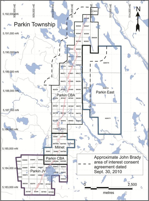
Page 10 of 554. PROPERTY DESCRIPTION AND LOCATION
The Property includes four land packages in Parkin and Norman Townships within the City of Greater Sudbury,
Ontario, Canada:
• Wallbridge's Milnet property;
• Wallbridge's Glencore Parkin property (Parkin JV in Figure 1);
• Wallbridge's CBA Parkin properties; and
• Wallbridge’s Parkin East property.
As of the effective date, these included 49 mining claims, 12 mining leases and 4 patents covering 2,280.83
hectares (Figure 1). A complete listing of the parcels is provided in Table 1.
THE PARKIN OFFSET JOINT VENTURE AGREEMENT
The Property is the subject of the Option and Joint Venture Agreement (“the Agreement“) between Wallbridge and
Implats dated August 19, 2008, which was amended September 28th, 2008 and April 2nd, 2011. In 2011, Implats
completed the $6,200,000 expenditures required to earn a 50% interest in the Property. Implats may earn an
additional 15% by funding a Feasibility Study. Wallbridge may request Implats fund its portion of development
funding through to commercial production on a loan basis.
THE MILNET OPTION AGREEMENTS
The Milnet property was acquired in February 2000 when Wallbridge entered into two separate option
agreements to acquire the Milnet surface and mining rights from Mr. J. Richardson and Ike Burns Metal Inc.
The Richardson agreement involved the surface and mining rights for three patented parcels. Wallbridge
purchased the Richardson leases in three annual payments of $10,000 from February 15, 2000 to 2002. The
transfer of title occurred in the summer of 2003 and Wallbridge is now recorded as the current holder.
The second agreement, known as the Ike Burns Metal Inc. Option, involved five leases. The agreement granted
Wallbridge the right to purchase the leases on or before January 26, 2005 upon annual cash payments of $10,000
(year 1), $20,000 (years 2, 3 and 4), and $30,000 (year 5) and a 1.5% NSR. Purchase of the property occurred at the
time of the final $30,000 payment on January 26, 2005. The leases are in good standing and are 100% held in the
name of Wallbridge Mining Company.
THE GLENCORE PARKIN PROPERTY OPTION AND JOINT VENTURE AGREEMENT
Pursuant to an Option and Joint Venture Agreement made as of January 1, 2006, between Glencore (then
Falconbridge Limited) and Wallbridge, Glencore holds a 1.5% net smelt return (“NSR”) royalty on the Glencore
Parkin property which increases to 5% if ore is processed at a non-Glencore treatment facility. Glencore also holds
other certain rights on the Glencore Parkin property as follows:
If a Feasibility Study defines a deposit with proven and probable reserves plus measured and indicated mineral
resources containing greater than $750,000,000 of contained metal value (using US$ $4.50 Ni, $1.00 Cu, $15.00 Co,
$700 Pt, $200 Pd, and $400 Au), then Glencore may increase its interest to 60% by incurring 200% of Wallbridge’s
total Expenditures incurred after January 1st, 2005. If Glencore exercises its option to acquire a 60% interest in
the Wallbridge Glencore Parkin property in circumstances wherein Implats would otherwise have earned a 65%
interest, the resulting Parkin Offset Joint Venture Interests in the Glencore Parkin property would be as follows:
Page 11 of 55• Glencore 60%
• Implats 30%
• Wallbridge 10%
Glencore also has a one-time option to earn a 50% interest in the Glencore Parkin property if Commercial
Production is not achieved by January 1, 2016, by funding work on the Property until it incurs 200% of
Wallbridge's total Expenditures incurred after January 1st, 2005. If Glencore exercises this one time option in
circumstances wherein Implats would but for such an event have earned a 65% interest, the resulting Parkin Offset
Joint Venture Interests in the Glencore Parkin property would be as follows:
• Glencore 50%
• Implats 32.5%
• Wallbridge 17.5%
Glencore also retains the right to process nickel ores from the Glencore Parkin property at fair rates that take into
account the cost structure and efficiencies of the designated facilities. For ores in which less than 33% of the
contained metal value is contributed by nickel Wallbridge shall have the right to seek competitive bids for the
processing of the ore, or to investigate the feasibility of partially or entirely processing the material itself. Glencore
retains the right of first refusal to process non-nickel ores by matching the terms available to Wallbridge.
CHAMPION BEAR PARKIN JOINT VENTURE AGREEMENT
Pursuant to an option and joint venture agreement dated April 10, 2008, and amended June 8, 2009, Wallbridge
acquired a 50% interest in the Champion Bear Resources Ltd. (“Champion Bear”) CBA Parkin property by making a
$100,000 cash payment to Champion Bear, issuing Champion Bear 263,158 common shares of Wallbridge and
incurring exploration expenditures on the Champion Bear Parkin Properties in the amount of $2,000,000 before
August 19, 2011. Wallbridge may earn an additional 25% interest in the CBA Parkin property by completing at its
cost a Definitive Feasibility Study on a deposit. The agreement provides the non-operator the option to request that
the operator fund the non-operator’s pro rata share of Expenditures on a project loan basis.
Implats has vested a 50% interest in the CBA Parkin property. Should Implats increase their interest to 65% by
funding a Feasibility Study, the CBA Parkin property would have the following ownership interests:
• Implats 65%
• Champion Bear 25%
• Wallbridge 10%
The CBA Parkin property is also subject to an underlying Consent Agreement between Wallbridge, Champion Bear
and John Brady dated September 30, 2010, and a related agreement between Champion Bear and John Brady dated
September 30, 1998, and amended December 20, 1999, and August 2, 2000. John Brady holds a 2.5% NSR royalty
on the CBA Parkin property, 60% of which may be acquired for $1.5 million at any time until the claims have been
put into production. John Brady is also entitled to an advance royalty payment of $6,000 payable on March 30th
and September 30th in each year that the claims have not been put into production or returned to John Brady; the
advance royalty payments are deductible from future NSR royalty payments. John Brady’s rights under the
agreement pertain to the CBA Parkin property and a 400 metre radius surrounding the property, not including any
mineral claims, leases, or patents existing as of September 30, 2010. Any claims intended to be dropped must be
returned to John Brady with one year’s good standing.
Page 12 of 55CALLINAN ROYALTY OPTION
The Parkin East property is subject to a Master Agreement, First Option Agreement, and Second Option Agreement
between Wallbridge and Callinan Royalties Corporation (Callinan), each dated December 12, 2012. Under these
agreements, Callinan may purchase up to a 2% NSR royalty on the Parkin East property at any time during the
option term by paying the following:
• For the first 1% NSR, $2M with an inflation adjustment, and
• For the second 1% NSR, a value equal to the after-tax NPV using a negotiated discount rate.
Page 13 of 55Table 1. Summary of Claims, Leases and Patents
1. Milnet Impala
patents:
legal description PID # map area area (ha) rights held holder work reserve
1 L5 C2 NW1/4 N1/2 73524-0053 Parkin 16.19 MSR WMCL 0
(S5265)
2 L6 C2 NE1/4 S1/2 & L5 73524-0054 Parkin 32.37 MSR WMCL 88,859
C2 NW1/4 S1/2 (S5480
& S5481)
Total 48.56 ha $88,859
Note: - Lands purchased from J. F. Richardson, Feb. 4, 2000, subject to 1.5% NSR
mining leases:
lease expiry lease
legal description PID # map area area (ha) rights held holder date number work reserve
3 S647601, S647202, 73524-0015 Parkin 64.75 MSR WMCL 31-Jul-2029 108251 3,930,511
S647603, S647604
4 S647605 73524-0016 Parkin 16.19 MSR WMCL 31-Jul-2029 108250 0
Totals 80.94 ha $3,930,511
Note: - lands purchased from Isaac Burns Metals Inc. Feb. 2, 2000, subject to 1.5% NSR
Project totals 129.50 ha $4,019,370
Land fees and payments: mining land tax - $194.25
lease rental - $442.81
municipal taxes - $1,830.96
$2,468.02
2. Parkin Impala
mining leases:
lease expiry lease
legal description PID # map area area (ha) rights held holder date number work reserve
1 S57843 73521-0344 Norman 15.78 MSR WMCL 28-Feb-2032 108706 0
2 S60119, S60120, S60121, 73521-0353 Norman 137.81 MSR WMCL 31-May-2020 107244 0
S60122, S60123, S60124,
S60125, S60126
3 S57463 73521-0354 Norman 15.17 MSR WMCL 30-Jun-2020 107246 0
4 S60354 73524-0009 Parkin 16.39 MSR WMCL 30-Sep-2021 108578 0
5 S59645, S59646, S59647, 73524-0010 Parkin 65.05 MSR WMCL 31-Aug-2021 108577 0
S59648, S59649
6 S21893, S22791 73524-0012 Parkin 33.10 MSR WMCL 31-Mar-2020 107243 407,613
7 S56865, S56866, S56867, 73524-0013 Parkin 120.59 MSR WMCL 31-May-2020 107245 0
S56868, S56869, S56870,
S56881, S56883
8 S56862, S56863, S56864, 73524-0014 Parkin 99.78 MSR WMCL 30-Jun-2020 107247 404,651
S57460, S57461, S57462
Totals 503.67 ha 812,264
patents
legal description PID # map area area (ha) Rights held Holder work reserve
L7 C6 NE1/4 of N1/2, 73521-0054 Norman 15.93 MSR WMCL 0
9 (former claim S3244)
L6 C6 NW1/4 of N1/2, 73521-0066 Norman 15.17 MSR WMCL 0
10 (former claim S27567)
Totals 31.10 ha $0
Note: - JV agreement WMCL/Glencore (fmr Xstrata) January 1, 2006
- recorded interests - WMCL 98.5% - Glencore 1.5% (treated as NSR)
Land fees and payments: mining land tax - $124.44
lease rental - $1,511.63
municipal taxes - $1,654.74
total $3,290.81
Project totals 534.77 ha $812,264
Page 14 of 553. CBA Parkin Impala
mining claims:
work
claim number map area area (ha) units Holder recorded date work due date Status required work reserve
1 681637 Parkin 16 1 CBRL 27-Apr-1983 02-Sep-2017 WRP 400 0
2 681638 Parkin 16 1 CBRL 27-Apr-1983 02-Sep-2017 WRP 400 0
3 681639 Parkin 16 1 CBRL 27-Apr-1983 02-Sep-2017 WRP 400 0
4 681640 Parkin 16 1 CBRL 27-Apr-1983 02-Sep-2017 WRP 400 0
5 681641 Parkin 16 1 CBRL 27-Apr-1983 02-Sep-2017 WRP 400 17,865
6 681642 Parkin 16 1 CBRL 27-Apr-1983 02-Sep-2017 WRP 400 17,413
7 681643 Parkin 16 1 CBRL 27-Apr-1983 02-Sep-2017 WRP 400 1,084
8 681644 Parkin 16 1 CBRL 27-Apr-1983 02-Sep-2017 WRP 400 1,031
9 681645 Parkin 16 1 CBRL 27-Apr-1983 02-Sep-2017 WRP 400 25
10 681708 Parkin 16 1 CBRL 27-Apr-1983 02-Sep-2017 WRP 400 0
11 681709 Parkin 16 1 CBRL 27-Apr-1983 02-Sep-2017 WRP 400 15,634
12 721031 Parkin 16 1 CBRL 28-Sep-1983 03-Feb-2017 WRP 400 25
13 787734 Parkin 16 1 CBRL 13-Sep-1984 19-Jan-2017 WRP 400 25
14 854516 Parkin 16 1 CBRL 30-Sep-1985 05-Feb-2017 WRP 400 245,035
15 854517 Parkin 16 1 CBRL 30-Sep-1985 05-Feb-2017 WRP 400 302,519
16 864620 Parkin 16 1 CBRL 28-Oct-1985 04-Mar-2017 WRP 400 25
17 864621 Parkin 16 1 CBRL 28-Oct-1985 04-Mar-2017 WRP 400 25
18 894922 Parkin 16 1 CBRL 12-Jun-1986 18-Oct-2017 WRP 400 0
19 894923 Parkin 16 1 CBRL 12-Jun-1986 18-Oct-2017 WRP 400 0
20 983946 Parkin 16 1 CBRL 15-Apr-1987 21-Aug-2017 WRP 400 409
21 983947 Parkin 16 1 CBRL 15-Apr-1987 21-Aug-2017 WRP 400 409
22 983948 Parkin 16 1 CBRL 15-Apr-1987 21-Aug-2017 WRP 400 409
23 983949 Parkin 16 1 CBRL 15-Apr-1987 21-Aug-2017 WRP 400 409
24 983950 Parkin 16 1 CBRL 15-Apr-1987 21-Aug-2017 WRP 400 409
25 983951 Parkin 16 1 CBRL 15-Apr-1987 21-Aug-2017 WRP 400 409
26 983952 Parkin 16 1 CBRL 15-Apr-1987 21-Aug-2017 WRP 400 409
27 983953 Parkin 16 1 CBRL 15-Apr-1987 21-Aug-2017 WRP 400 409
28 983954 Parkin 16 1 CBRL 15-Apr-1987 21-Aug-2017 WRP 400 0
29 983955 Parkin 16 1 CBRL 15-Apr-1987 21-Aug-2017 WRP 400 0
30 983956 Parkin 16 1 CBRL 15-Apr-1987 21-Aug-2017 WRP 400 0
31 984370 Parkin 16 1 CBRL 30-Apr-1987 05-Sep-2017 WRP 400 0
32 984371 Parkin 16 1 CBRL 30-Apr-1987 05-Sep-2017 WRP 400 0
33 984372 Parkin 16 1 CBRL 30-Apr-1987 05-Sep-2017 WRP 400 0
34 984373 Parkin 16 1 CBRL 30-Apr-1987 05-Sep-2017 WRP 400 0
35 984391 Parkin 16 1 CBRL 30-Apr-1987 05-Sep-2017 WRP 400 0
36 984392 Parkin 16 1 CBRL 30-Apr-1987 05-Sep-2017 WRP 400 0
37 984393 Parkin 16 1 CBRL 30-Apr-1987 05-Sep-2017 WRP 400 0
38 994721 Parkin 16 1 CBRL 23-Dec-1987 29-Apr-2017 WRP 400 0
39 994722 Parkin 16 1 CBRL 23-Dec-1987 29-Apr-2017 WRP 400 0
40 1042895 Parkin 16 1 CBRL 07-Apr-1989 13-Aug-2017 WRP 400 0
41 1163243 Parkin 16 1 CBRL 25-Oct-1999 01-Mar-2017 WRP 400 0
42 1174660 Parkin 16 1 CBRL 31-Jan-1995 31-Jan-2017 WRP 400 120,311
43 1179474 Parkin 16 1 CBRL 24-Aug-1992 30-Dec-2017 WRP 400 25
44 1211020 Parkin 16 1 CBRL 23-Nov-2001 30-Mar-2017 WRP 400 71,725
45 3004244 Parkin 64 4 CBRL 12-Aug-2002 12-Aug-2017 WRP 1,600 0
Totals 768 ha 19,200 $796,039
Work required going forward 2014 $0
2015 $0
2016 $0
mining leases:
lease renew lease
legal description PID # map area area (ha) Rights held Holder date number work reserve
49 S693958 73524-0018 Parkin 16.19 MSR CBRL 31-Oct-2032 108882 398,841
50 S693959, S693960 73524-0017 Parkin 32.38 MSR CBRL 31-Oct-2032 108881 401,203
Totals 48.56 ha $800,044
Project totals 816.56 ha $1,596,083
Note: - This property is operated under a JV agreement dated April 10, 2008
- underlying agreement to John Brady, NSR and advanced royalty
Land fees and payments: lease rental - $145.70 adv. Royalty - $12,000
municipal taxes - $1,596.83
total $1,742.53
Page 15 of 554 Parkin East
mining claims:
work
claim number map area area (ha) units Holder recorded date work due date Status required work reserve
1 4245171 Parkin 240 15 WMCL 09-Aug-2011 09-Aug-2018 A 6000 0
2 4245172 Parkin 256 16 WMCL 09-Aug-2011 09-Aug-2018 A 6400 0
3 4245173 Parkin 64 4 WMCL 09-Aug-2011 09-Aug-2018 A 1600 0
4 4245174 Parkin 240 15 WMCL 09-Aug-2011 09-Aug-2017 A 6000 0
Project totals 800.00 ha 20,000 $0
Work required going forward 2014 $0
2015 $0
2016 $0
Note: Subject to 400m area of interest per J. Brady consent agreement, Sept. 30, 2010
5. ACCESSIBILITY, CLIMATE, LOCAL RESOURCES, INFRASTRUCTURE AND
PHYSIOGRAPHY
Access to the Property is by Regional Road 80 for a distance of 18.3km north from Sudbury to the town of Val
Therese. From there one continues easterly for a distance of 6.7km along Regional Road 80 to the junction with
Regional Road 84. One then follows Regional Road 84 north for a distance of about 7km to the Town of Capreol.
From Capreol one proceeds northeast along all-weather gravel roads past KGHM International’s Podolsky Mine
and Vale’s past producing Whistle Mine. A major north-south logging road crosses the centre of the Property
immediately west of Malbeuf Lake.
The Properties are located within the Canadian Shield. The topography is typical of this part of the Canadian Shield
with subdued relief and an average elevation of about 150 metres above sea level. Total relief on the property is
about 30m, with local relief limited to 5 to 10m.
During Pleistocene glacial erosion and deposition, the drainage pattern became disrupted and there are numerous
small lakes and ponds. The terrain is characterized by rocky hills which alternate with depressions filled with
glacial deposits and swampy ground with approximately 20% lakes, rivers and swamps. Bedrock exposure is
estimated at less than 5%. Overburden has been reported to range from 0 to 17 metres thick in the project area
with thicker overburden generally occurring in linear troughs. Drainage is typically from the northwest to the
southeast as shown by the Roberts and Vermillion Rivers and Mowat and Parkin Creeks. This trend seems to be a
reflection of the regional strike of the rock units and in the case of the Vermillion River and Mowat Creek, the
reflection of fault structures.
The area has a moderate continental climate and temperatures average 24.8C in summer and –8.4C in winter.
Annual precipitation averages 62.2cm of rain and 247.5cm of snow. Exploration work can be carried out year
round. There are ample supplies of both water and power to support any future mining operation.
The Regional Municipality of Sudbury is a major centre in Northeastern Ontario with a population of about
160,000. Mining in Sudbury has been active for over 125 years. Vale, Glencore, and KGHM International all have
operating mines in the Sudbury area which is the western world's largest producer of nickel and the location of the
largest fully integrated mining complex in the world. Over 300 local companies involved in mining related
activities offer expertise covering all areas of exploration, mining and environmental rehabilitation.
Page 16 of 556. HISTORY
The earliest government geological mapping reported for the area was carried out by R. Bell (1888-1890) as part
of his examination of the Sudbury region. Later in the 1930s, L.F. Kindle mapped the current Hutton and Parkin
Townships and parts of Roberts and Botha Townships. Other government work tended to focus on determining
the uranium or placer gold potential for the area. The Ontario Department of Mines produced a preliminary map
and Geological Report 80 covering Hutton and Parkin Township (Meyn 1970) entitled "Geology of Hutton and
Parkin Townships". The Geophysics Division of the Geological Survey of Canada conducted an airborne
magnetometer survey from June 1959 to October 1960 and produced Milnet Map 1512G that covers the property
area.
The Ministry of Northern Mines and Development Assessment files record exploration activity in the area since the
1890’s. Early prospecting along the Vermillion River identified small quantities of placer gold in Hutton Township.
Quantities of gold from this area proved to be too meagre to support commercial exploitation, but it did encourage
additional prospecting in the area. The earliest mining activity was concentrated in the Moose Mountain Iron
range, a belt of silicate/magnetite facies banded iron formation located in central Hutton Township. The Moose
Mountain Mine produced iron pellets between 1908 and 1924 and again from 1959-1966 (Meyn, 1970).
The recent history of ownership is described in Section 4 and the history of exploration is summarised in Section 9.
7. GEOLOGICAL SETTING AND MINERALIZATION
Ni-Cu-PGE deposits in Sudbury occur within and adjacent to the Sudbury Structure that formed as a result of a
major Early Proterozoic meteorite impact 1,850 million years ago (Ames and Farrow, 2007; Figure 2). The
Sudbury Structure straddles the unconformity between Archean gneisses and plutons of the Superior Province and
overlying Paleoproterozoic Huronian supra-crustal rocks of the Southern Province. It is geographically divided
into the North, South, and East Ranges and comprises four geologic domains:
1. The Sudbury Igneous Complex (SIC) occurs as a 60 km x 27 km elliptical bowl-shaped body that formed
from a meteorite impact melt sheet. It consists of a basal xenolithic norite breccia (contact sublayer)
overlain by norite, quartz-gabbro and granophyre and historically has been referred to as the "Nickel-
Bearing Irruptive", the "Sudbury Nickel Irruptive" and the "Nickel Irruptive".
2. Concentric and radial dykes of diorite, granodiorite, and quartz diorite.
3. The footwall to the SIC contains a zone, up to 80 km wide, of Archean and Proterozoic rocks that are
fractured, brecciated (Sudbury breccia), and locally partially melted (e.g. Late Granite Breccia) or
recrystallized due to the meteorite impact and subsequent emplacement of the SIC.
4. The SIC is overlain by the Whitewater Group, comprising “fall-back” super-crustal breccia of the
Onaping Formation and the overlying basin-fill sedimentary rocks of the Onwatin and Chelmsford
Formations.
Mineral deposit types associated with the SIC are described in more detail in Section 8.
Page 17 of 55Figure 2. Sudbury Igneous Complex and Offset Dykes (Ames and Farrow, 2007).
Page 18 of 55PROPERTY GEOLOGY
The Property is underlain by 9.5 kilometres of the Parkin Offset dyke on the northeast corner of the Sudbury basin
(Figure 3). The southern part of the dyke intrudes mafic and felsic metavolcanic rocks of the Archean Parkin
Greenstone Belt. The northern part of the dyke intrudes Early Proterozoic Huronian marble, quartzite and
conglomerate unconformably overlying the Archean basement. The Huronian rocks have been subdivided into the
following litho-stratigraphic formations: Mississagi, Bruce, Espanola, Serpent, Gowganda, and Lorrain. These rocks
are intruded by late Proterozoic dykes of Nipissing diabase, Sudbury Swarm olivine diabase, and the offset dyke
quartz diorite related to the SIC.
The lithologies have been subjected to repeated deformation, with the exception of the late diabase dikes and SIC-
related Parkin Offset dyke. The earliest interpreted orogenic events are related to the emplaced of the quartz
monzonite batholith and related migmatitic rocks in the north. After uplift, erosion, and deposition of the
Huronian rocks, the area was again subjected to deformation and low-grade regional metamorphism during the
Penokean Orogeny.
The Parkin quartz diorite offset dyke is sub-vertical, or dips very steeply to the east, and has a width of 45 to 135
m. South of the Milnet mine the dyke strikes 033°. At Milnet, and on near the southern boundary of the CBA Parkin
north block the dyke follows two left-stepping (northwest trending) flexures, each for about 250 m. The dyke is
not continuous along the NW flexures trend with the pinched terminations interpreted to be a structural control on
the Milnet mine mineralization. North of these flexures, the dyke is between 30 and 90 metres thick and strikes for
several kilometres at 015°. The dyke includes quartz diorite as well as inclusion quartz diorite and meta-breccia.
Drilling in 2012 identified a significant late brittle fault (the “Parkin fault”) at depth beneath the Milnet Mine. The
fault strikes NE nearly parallel to the general trend of the parkin offset and dips 40-45 degrees to the south. The
projection of the fault corresponds very well with a very well developed surface lineament that surfaces just west
of the Milnet mine and can be traced along strike for many kilometres in both directions. Re-logging of select holes
at the southern end of the Parkin dyke identified several structures which appear to correspond with this fault,
suggesting that in this area it has bifurcated into a number of splays. Notably, there are very few intersections of
the Parkin Offset dyke below this fault and the displacement across the structure is not known.
Page 19 of 55Figure 3. Geology and Mineralisation of the Parkin Offset dyke.
Page 20 of 55MINERALIZATION
Nickel, copper, PGE sulfide mineralization within Offset dykes in Sudbury occurs associated with inclusion bearing
phases of quartz diorite (“IQD”) and meta-breccia and is often concentrated within structural traps in the dykes
such as vertical or horizontal pinches/terminations, bends in the dyke, splays/convergences of the dyke, along
margins or “pressure shadows” of large blocks caught up in the dyke (particularly coarse mafic blocks).
Mineralization at Parkin includes zones of massive to stringer/disseminated zones of pyrrhotite, chalcopyrite,
pyrite and pentlandite.
The historic Milnet Mine, reports past production of 157,130 tons averaging 2.25 g/t platinum, 2.98 g/t palladium,
0.93 g/t gold, 1.49 % nickel and 1.54 % copper (Meyn, 1970). At the time of production, orebodies #1 and #2 were
mined to a depth of approximately 150m.
Drilling by the Joint Venture beneath the Milnet Mine discovered the Milnet 1500 zone in 2009, intersecting 14.24
metres (1,499.66-1,513.90 m) containing 8.00g/t TPM, 2.57% copper and 0.78% nickel. More recent drilling
intersected 8.0 metres (1,473-1,481m) grading 4.32g/t TPM, 4.11% nickel, and 0.60% copper and in another hole
12.85 metres (1665.80-1678.65m) containing 1.85 g/t TPM, 0.33 % nickel and 0.73 % copper. Modelling of
mineralized intersections and borehole electromagnetic geophysics indicates that the Milnet 1500 Zone is a
minimum of 400 metres by 35-60 metres with unknown true width and open. The full extent of the zone is not
known and most of the dyke in the area has not been tested by drilling
The Parkin Resource on the Glencore Parkin property (more fully described in Section 14) includes 5 zones along a
strike length of ~750m and less than 200m from surface with combined Indicated Resources of 264,000 tonnes
averaging 0.70% Cu, 0.65% Ni, 0.03% Co, 0.62g/t Pt, 0.80g/t Pd, 0.23g/t Au, and 6.3g/t Ag and combined Inferred
Resources of 87,000 tonnes averaging 0.7% Cu, 0.4% Ni, 0.02% Co, 1.2g/t Pt,1.0 g/t Pd, 0.6 g/t Au, and 8.8 g/t Ag
(Soever, 2002). Significant intersections within the Parkin Resource are shown in Table 2.
Table 2. Significant Intersections within the Parkin Resource.
Hole From (m) To (m) Length (m) Cu (%) Ni (%) Pt (g/t) Pd (g/t) Au (g/t) CuNi (%) TPM (g/t) H.T. Width (m)
WMP-010 32.9 50.97 18.07 1.16 1.19 0.78 1.96 0.27 2.35 3.01 11.7
WMP-012 22.7 28.9 6.2 1.1 0.94 0.97 0.76 0.28 2.04 2.01 4.1
WMP-020 6.43 20.2 13.77 1.57 0.16 1.67 1.52 1.7 1.73 4.89 10.6
WMP-026 10.17 14.75 4.58 2.27 0.9 1.28 1.32 0.35 3.17 2.95 3.5
WMP-067 49 58.7 9.7 1.04 0.51 1.65 1.32 0.57 1.55 3.54 6.3
WMP-009 89.86 92.57 2.7 0.63 0.22 1.92 1.07 4.5 0.85 7.49 1.8
WMP-009 94.86 104 9.14 0.45 0.14 3.17 2.1 1.07 0.59 6.34 6
WMP-103 60.94 63.98 3.04 1.02 2 1.28 1.31 0.23 3.02 2.82 2
WMP-110 99.1 103.2 4.1 1.07 1.12 0.63 1.12 0.17 2.19 1.92 3.4
WMP-111 104.81 115.13 10.32 1.03 0.79 0.49 0.88 0.28 1.82 1.65 7.8
WMP-002 82.62 97.55 14.93 1.38 0.36 2.01 1.84 0.74 1.74 4.59 0.6
WMP-117 113.48 116.81 3.33 0.95 0.15 2.42 2.67 0.74 1.1 5.83 2
Several significant intersections (Table 3) drilled subsequent to and below the Parkin Resource are open laterally
and to depth and are associated with off-hole BHEM conductors that have never been drill tested.
Page 21 of 55Table 3. Significant intersections below the Parkin Resource.
Hole From (m) To (m) Length (m) Cu (%) Ni (%) Pt (g/t) Pd (g/t) Au (g/t) CuNi (%) TPM (g/t) H.T. Width (m)
P-058 344 345.65 1.65 1.9 1.02 2.18 1.55 1.14 2.92 4.87 1.06
WMP-099 166 167.95 1.95 1.12 1.49 0.88 1.26 0.12 2.61 2.26 1.38
WMP-100 247.02 248.77 1.75 0.26 0.25 0.29 0.55 0.15 0.51 0.99 **
WMP-101 117.59 120.02 2.43 1.50 0.40 1.55 0.84 0.33 1.90 2.73 **
WMP-113 228.5 234.67 6.17 1.01 0.92 1.16 2.06 0.39 1.93 3.61 3.54
WMP-131 190.5 193.76 3.26 3.01 0.68 1.04 2.13 0.17 3.69 3.35 1.38
WMP-133 234.87 236.87 2 0.36 0.27 0.43 0.88 0.45 0.63 1.76 0.62
WMP-134 230.93 237.95 7.02 0.66 0.64 0.82 1.24 0.25 1.30 2.31 2.40
*Horizontal Thickness, **Vertical drill hole, orientation of mineralization not known.
A channel sample from the Brady Showing on the Champion Bear South Block returned 11.2% Cu, 0.6% Ni, 9.2g/t
Pt, 4.3g/t Pd and 1.6g/t Au over 2.70 metres at surface.
Anomalous gold values have also been intercepted on the Champion Bear south block, and include 44g/t Au over
1.4m (543.30-544.70m in WCB-006).
Page 22 of 558. DEPOSIT TYPES
Sudbury is one of the most significant mining districts in the world. Historical production over the past 125 years
plus current reserves in Sudbury have been estimated at approximately 1.6 billion tonnes of ore containing over 60
million ounces of platinum group metals plus gold, over 40 billion pounds of nickel and over 35 billion pounds of
copper (Eckstrand and Hulbert, 2007; Ames and Farrow, 2007, Lightfoot and Farrow, 2002).
Significantly, despite the long history of mining significant discoveries continue to be made in Sudbury, including
over 19 million ounces of PGEs discovered in since 1990 (Table 4).
Table 4. Recent discoveries in Sudbury with greater than 1 million ounces of PGEs.
Resource Ni Cu Pt + Pd Pt + Pd
>1 M oz Examples
Mt % % g/t Moz
1. Capre1 ? ? ? ? ?
2
2. Victoria 14.5 2.5 2.5 7.6 3.5
3. McCreedy East FW3 6.8 0.9 9.9 13.4 2.9
4. Nickel Rim South4 13.0 1.4 3.1 4.3 1.8
5. Totten Mine5 10.1 1.5 1.97 4.8 1.6
6. Kelly Lake6 11.4 1.72 1.41 3.8 1.4
7. Victor Deep FW6 6.16 1.9 6.2 6.7 1.3
1 2 3 4
No public data; Quadra FNX Press Release dated January 16, 2012; personal communication; Xstrata
Nickel Ore Reserves and Mineral Resources Statement dated December 9, 2009; 5Inco Press Release dated
October 1999; 62005 Sudbury – Inco and Falconbridge Synergies Fact Sheet.
There are several main types of mineral deposits in the Sudbury area:
1. Contact deposits, including massive sulfide nickel, copper, cobalt, platinum, palladium and gold
mineralisation along the lower contact of the SIC, both within the contact sublayer and within the
immediately adjacent Footwall Breccia;
2. Footwall deposits, including sulfide veins and stringers containing copper, nickel, platinum, palladium,
and gold in the brecciated footwall rocks beneath the SIC;
3. Offset dyke deposits, including massive sulfide nickel, copper, cobalt, platinum, palladium and gold
mineralisation associated with brecciated and inclusion bearing phases of the quartz diorite offset
dykes;
4. Structurally and/or hydrothermally remobilized sulfide nickel, copper, cobalt, platinum, palladium and
gold mineralisation; and
5. Hybrid type deposits representing combinations of the above.
The Property is being explored for Offset dyke type deposits associated with the Parkin Offset dyke. Sudbury Offset
dyke deposits account for a quarter to a third of all historic production in Sudbury and occur as massive and semi-
massive sulphide zones within multi-phase quartz diorite offset dykes that extend radially from and concentrically
around the Sudbury Igneous Complex.
Page 23 of 55Examples of recent Offset dyke deposit discoveries in the region include the Kelly Lake Deposit within the Copper
Cliff Offset dyke (Table 4, Figure 4) and the Totten and Victoria deposits within the Worthington Offset dyke (Table
4, Figure 5). The conceptual exploration target for Offset deposit target includes 2 to 10 million tonnes containing
1-3 g/t platinum, 1-3 g/t palladium, 1-3 % copper, 0.5-2 g/t gold, and 1-3 % nickel. This represents a body that is
50-100 metres in strike length, 10-20 metres in thickness and 100’s of metres of plunge extent. This target is
conceptual in nature, is based on examples of Offset dyke deposits elsewhere in Sudbury and is not necessarily
indicative of mineralisation on the Property. There has been insufficient work on the property to determine
whether deposits of this size and grade exist on the Property.
Target mineralization includes massive and semi-massive accumulations of sulphide, including pyrrhotite >
chalcopyrite > pentlandite. Sulphide accumulations are associated with inclusion bearing phases of quartz diorite
and are known to concentrate in structural traps such as vertical or horizontal pinches or terminations in the dyke,
bends in the dyke, splays/convergences of dyke branches, along the margins or within “pressure shadows” of large
blocks caught up in the dyke, and at intersections of the offset dykes with coarse mafic intrusions in the wall rock.
Increased PGEs are typically associated with more fractionated chalcopyrite rich zones within Offset dyke deposits,
which can extend from the dyke outwards into the surrounding country rock, where it often associated with
adjacent zones of Sudbury breccia, meta-breccia or anatexite.
These structural traps are largely controlled by the geology of the wall rock to the Offset dykes (geological units,
contacts and structures). Understanding these wall rocks is crucial to developing and prioritizing drill targets
below the depth of penetration of surface geophysics.
The massive and semi-massive accumulations of sulphide are strongly conductive and borehole EM is used
routinely on all drill holes of significant depth. The rule of thumb is that current borehole EM technology (BHUTEM
4) can detect an off-hole conductor about the same distance as the median dimension of that conductor, with
several practical caveats. Maximum effectiveness requires strong coupling between the loop configuration and the
conductor. As well, quality low-noise data depends on precise knowledge of transmitter-receiver geometry, which
requires gyro surveying of the borehole and sub-metre GPS surveying of the borehole collar and loop
configuration. Due to the fragmental nature of the ore deposits and host rocks, a deposit might not be electrically
continuous and actually made up of several conductors; in this case the distance it can be detected from will be
reduced relative to the overall size of the sulphide mass. In practice, for the target type in question and providing
there is quality data, borehole EM is thought to dependably test a radius of 75-100 metres around the drill hole.
Page 24 of 55You can also read