37 St Vincent Ave Remuera - Application for Resource Consent and Assessment of Environmental Effects - Remuera Residents Association Inc.
←
→
Page content transcription
If your browser does not render page correctly, please read the page content below
37 St Vincent Ave
        Remuera

Application for Resource Consent and
Assessment of Environmental Effects

                                       February 2021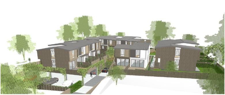
February 2021
                                                                                                                              37 St Vincent Limited

Contents
1   Introduction .................................................................................................................................... 4
2   The applicant and property details ................................................................................................. 5
3   Site and locality description ............................................................................................................ 6
4   Proposal........................................................................................................................................... 9
    4.1        Introduction ........................................................................................................................ 9
    4.2        Overall layout – buildings, access and landscaping ............................................................ 9
    4.3        Access and Parking ............................................................................................................ 13
    4.4        Infrastructure & Earthworks ............................................................................................. 13
    4.5        Construction Traffic and Noise ......................................................................................... 15
    4.6        Subdivision ........................................................................................................................ 15
    4.7        Summary ........................................................................................................................... 15
5   Consent requirements .................................................................................................................. 17
    5.1        Introduction ...................................................................................................................... 17
    5.2        Auckland Unitary Plan – Operative in Part (“the Unitary Plan”)....................................... 17
    5.3        Permitted activities ........................................................................................................... 24
    5.4  NES: Assessing and Managing Contaminants in Soil to Protect Human Health Regulations
    2011 24
    5.5        Reasons for consent conclusion........................................................................................ 25
6   Environmental effects assessment ............................................................................................... 26
    6.1        Character and Amenity and Streetscape .......................................................................... 26
    6.2        Dominance, daylight/shading and privacy/outlook .......................................................... 27
    6.3        Transport ........................................................................................................................... 29
    6.4        Infrastructure and Earthworks .......................................................................................... 32
    6.5        Geotechnical ..................................................................................................................... 34
    6.6        Contamination .................................................................................................................. 35
    6.7        Construction Noise and Vibration ..................................................................................... 37
    6.8        Effects conclusion ............................................................................................................. 39
7   Statutory assessment .................................................................................................................... 40
    7.1        Section 104(1)(b)(1) – National Environmental Standard ................................................ 40
    7.2        Section 104(1)(b)(iii) – National Policy Statement on Urban Development 2020 ............ 41
    7.3        Section 104(1)(b)(v) – Auckland Regional Policy Statement............................................. 41
    7.4        Section 104(1)(b)(vi) – Auckland Unitary Plan (district level provisions).......................... 42
    7.5        Assessment criteria ........................................................................................................... 48
8   Section 104(1)(c) – Other matters ................................................................................................ 59
    8.1        Introduction ...................................................................................................................... 59

                                                                                                                                            2|P a g e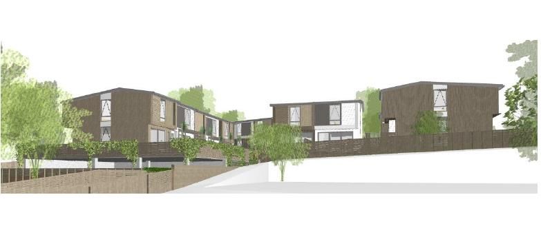
February 2021
                                                                                                                            37 St Vincent Limited

9      Part 2 of the Resource Management Act 1991 ............................................................................. 61
10 Notification.................................................................................................................................... 62
       10.1       Public Notification ............................................................................................................. 62
       10.2       Limited notification ........................................................................................................... 63
11 Conclusion ..................................................................................................................................... 66

Supporting Documents Provided

A.     Certificate of Title
B.     Architectural Plans
C.     Architectural Design Statement
D.     Landscape Plans and Specification
E.     Infrastructure Report and Engineering Plans and Scheme Plans
F.     Transport Assessment
G.     Geotechnical Report
H.     Waste Management Plan
I.     Pre App Minutes

                                                                                                                                          3|P a g e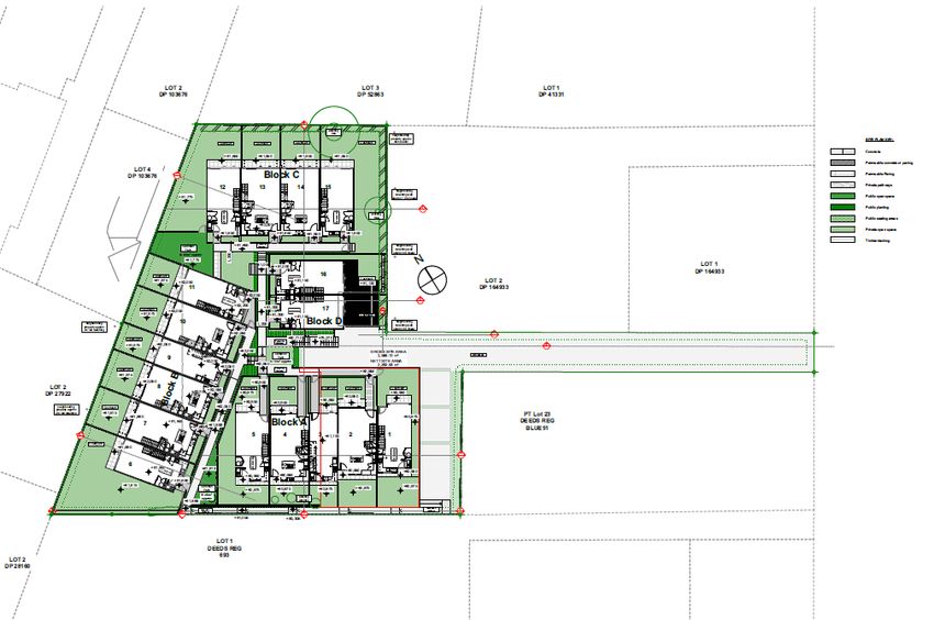
February 2021
                                                                                            37 St Vincent Limited

1    INTRODUCTION

This report is submitted in support of a land use consent application by 37 St Vincent Limited (“the applicant”
for the construction of 17 residential units on the subject site (“the site”) at 37 St Vincent Ave, Remuera.

The residential units will comprise 15 three bedroom and 2 two-bedroom units. All units will be two levels.
Each unit will have 1 carpark which will be located in an under croft structure. Refuse storage and disposal
is also proposed from the parking area. It is proposed to undertake a fee simple subdivision around the
development after the development is approved. The is accessed from a 5.49m wide accessway from St
Vincent Ave. A 1m wide pedestrian pathway is provided within this accessway.

The site is subject to the Residential-Mixed Housing Urban Zone and also subject to the Macroinvertebrate
Community Index Overlay. The site will be redeveloped to remove the existing residential dwelling and
associated structures to provide medium density housing which is aligned with the development outcomes
intended for the Mixed Housing Urban zone, and representative of the future planned form of development
for the locality. The proposed development has been designed to maintain sensitivity to the current
residential neighbourhood and existing dwellings whilst providing for development that adds interest and
diversity in an environment where the planned outcome identified in the AUP is for higher density than
currently exists.

Overall, the proposal is considered to have less than minor adverse effects on the environment and is
consistent with the objectives, policies and assessment criteria in the Unitary Plan.

This report has been prepared in accordance with the requirements of Section 88 and the fourth schedule
of the Resource Management Act 1991 (RMA) and is intended to provide the information necessary for a
full understanding of the proposal and any actual or potential effects the proposal may have on the
environment.

This report contains the following information:

    ▪    A description of the site and surrounding neighbourhood
    ▪    A description of the proposed activity
    ▪    An assessment of effects of the proposal on the environment; and
    ▪    An analysis of the provisions of the RMA and the relevant statutory plan documents

                                                                                                       4|P a g e
February 2021
                                                                                    37 St Vincent Limited

2   THE APPLICANT AND PROPERTY DETAILS

                             APPLICANT AND PROPERTY DETAILS
Applicant                37 St Vincent Limited
Address                  37 St Vincent Ave, Remuera
Legal Descriptions       Lot 1 DP71360
Site Area                2,565m2 (GROSS) 2,293 NETT

                          Auckland Unitary Plan: Operative in Part
Zone                     Mixed Housing Urban
Precinct                 N/A
Overlays                 ▪     Natural Heritage: Regionally Significant Volcanic Viewshafts And
                               Height Sensitive Areas Overlay [rcp/dp] - O1, One Tree Hill, Viewshafts
                               – 17.5m Not Affected
                         ▪     Natural Heritage: Regionally Significant Volcanic Viewshafts And
                               Height Sensitive Areas Overlay [rcp/dp] - W26, Mount Wellington,
                               Viewshafts – 17.5m Not Affected
Controls                 ▪     Macroinvertebrate Community Index - Urban
Road Classification      ▪     Local Road
Designations             ▪     Designations: Airspace Restriction Designations - ID 1102, Protection
                               of aeronautical functions - obstacle limitation surfaces, Auckland
                               International Airport Ltd – Not affected
Council GeoMaps Layers
Overland Flowpath        ▪     No overland flowpaths or floodplains apply across the site
Floodplain

                                                                                               5|P a g e
February 2021
37 St Vincent Limited
3 SITE AND LOCALITY DESCRIPTION
The site is located at 37 St Vincent Ave (the certificate of title is contained in Attachment A). The site is
located within the Mixed Housing Urban Zone under the Unitary Plan.
The site currently provides for an existing residential dwelling and also a garage. A private outdoor living
area including courtyard and tennis court is located directly adjacent to the north of the dwelling. Areas of
lawn are predominantly located in the northern and eastern parts of the site. There is an existing driveway
that provides vehicle access from St Vincent Ave to the subject site. There are also a number of trees located
within the property and along the driveway. The boundaries are bordered by hedges and there is a large
specimen tree to the north east corner of the site. The site has a gradual gradient and rises from the east to
the west by approximately nine and a half metres over a horizontal distance of approximately one hundred
and seven metres.
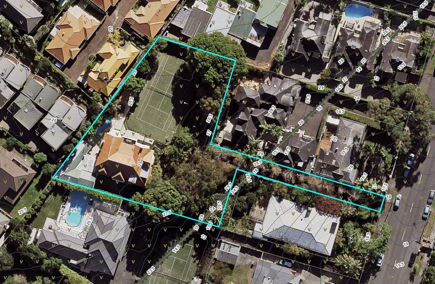
The site is an irregular shape, including a panhead entrance strip providing access to St Vincent Ave. The
total area of the site is 2,565m2 Gross and 2,293 Nett. An aerial image of the site is shown in Figure 1 below.
Figure 1: Subject site (outlined in blue) at 37 St Vincent Ave, Remuera. Source: Auckland Council Geomaps
6|P a g eFebruary 2021
37 St Vincent Limited
The existing 1920’s weatherboard clad dwelling is a large two storied house positioned on the south-west
corner of the large lot. The existing house is in average condition due to its age and would require a
reasonable amount of work to meet current building standards. This pattern of development (large
standalone homes on large lots) was historically very typical in this suburban neighbourhood and
underutilises the land. Subdivision and infill development has occurred in a lot of the surrounding lots with
No 37 and 43 St Vincent Avenue being one of the last remaining single dwellings on lots of a significant size.
Figure 2: Site Locality Zoning Plan
The locality and nearby sites/dwellings are outlined in detail in the Design Assessment submitted with the
application. The neighbourhood is occupied by a variety of dwelling types including large single house sites
(43 St Vincent Ave) and higher density multi-unit developments (26 Clonbern Road). The sites are generally
zoned Mixed Housing Urban, THAB or Mixed Housing Suburban.
7|P a g eFebruary 2021
37 St Vincent Limited
Figure 3: Neighbourhood Zoning Locality Plan
In relation to the surrounding environment, the site is located within the middle of the suburb of Remuera.
The residential suburb of Remuera is located to the east of Central Auckland. The suburb of Remuera is
bound by the Waitemata Harbour and Orakei Basin to the north, and the residential suburbs of Ellerslie and
Ladies Mile to the south, Newmarket to the West and Orakei to the East.
A number of community and recreational facilities including the Ellerslie Racecourse, Greenlane Train
Station, Bus routes, Remuera Club and the Remuera Town Centre are in close proximity to the application
site.
8|P a g eFebruary 2021
37 St Vincent Limited
4 PROPOSAL
4.1 Introduction
The proposal involves the demolition of the existing residential dwelling and associated structures and
vegetation to enable the construction of 17 residential dwellings, a common accessway to provide vehicle
access to and from the site, associated car parking and associated landscaping and common areas including
pedestrian pathways.
The proposed development is set out in detail on the Architectural Drawings and Design Statement
submitted with the application. Full details of the proposal are set out in the architectural drawings prepared
by Novak + Middleton contained in Attachment B to this report. Further, the Design Statement prepared by
Novak + Middleton is included as Attachment C to this application. The Landscaping Plans prepared by Local
are included as Attachment D to this application and outline in full detail the landscaping designs proposed
as part of this application.
Other details of the proposal relating to traffic, geotechnical matters (including groundwater), refuse
disposal methodology, subdivision and infrastructure are set out in the respective technical reports/plans
that are submitted with the application and also comprise the proposal.
4.2 Overall layout – buildings, access and landscaping
Full details of the proposal are set out in the architectural plans prepared by Novak and Middleton and
included as Attachment B to this report. The proposal includes the establishment of 17 residential dwellings
in a range of typologies including 15 three-bedroom units and two 2 bedroom units, each with 1 car park.
The layout of the proposed development is shown below in Figure 4.
9|P a g eFebruary 2021
37 St Vincent Limited
Figure 4: Layout of the proposed development
All carparks are provided within an under croft parking area which is accessed directly from the accessway
from the site. The under croft carpark features residential units above. Additionally, the refuse disposal
area is located in the carpark and a pedestrian ramp is also accessed from the carpark area.
10 | P a g eFebruary 2021
37 St Vincent Limited
Figure 5: Layout of the proposed carpark
A Design Statement has been prepared by Novak & Middleton to address the design and layout of the
proposed development. This is also contained in Attachment C to this application. The location of the
buildings in plan and elevation (floor level set out) was determined by a number of factors acknowledging
the existing development patterns and urban form in the locality, adherence with planning standards and
response to environmental conditions including orientation to achieve best sunlight access among other
considerations.
Figure 6: Perspective of the proposed development viewed from the north of the accessway.
The dwellings have been divided into four individual buildings that are similar in scale to some of the
surrounding houses in the neighbourhood and have been broken up into separate building blocks to blend
in and complement the existing development in the area. Outdoor living areas are provided for each dwelling
and are orientated to face north or west where possible.
11 | P a g eFebruary 2021
37 St Vincent Limited
Figure 7: Block profiles of proposed development
In relation to other landscaping on the site, a range of specimen trees are proposed including Magnolia,
Olive, Forest Pansy, Feijoa and Lemon as well as the retention of two existing trees. Hedging is also proposed
in the form of Geentys Green and Griselinia as well as a variety of climbers. A range of lower-level planting
mixes are also proposed across the site. For full details, refer to the Landscape Plans contained in
Attachment D.
Housing and Materials
The proposal includes a combination of housing typologies with 15 x three-bedroom dwellings and two x
two-bedroom, all two-level multi-unit buildings. Units, 1, 2, 3, 16 and 17 will be constructed above the
carpark under croft.
The proposed development provides for pitched roof attached dwellings, the upper-level frames of the
dwellings articulate, add depth, and add formal variety between the units. In addition, variety of the building
bulk is married with the use of different materials and finishes in a combination of light and dark tones to
introduce an appropriate level of formal variation between units.
The material palette includes a mixture of colour steel metal cladding, long run metal roofing, and cedar and
painted weatherboards, in a combination of light and dark tones. This establishes a modern durable
aesthetic for the development that does not dominate the street but instead recedes back and further
12 | P a g eFebruary 2021
37 St Vincent Limited
individualises the units. All retaining will be a combination of concrete block and retaining and all fencing
will be pine.
4.3 Access and Parking
It is proposed to provide a complying carpark scenario with associated manoeuvring for each parking space.
All of the parking spaces are a minimum of 2.4m wide and will be 5.0m long. The manoeuvring depths for
all carparks will be 7.1m except for spaces 16 and 17 which have a manoeuvring depth of 5.4m.
Primary access to the site is proposed to be provided via a reformed common vehicle accessway which is
5.49m wide and also includes a 1.0m wide pedestrian pathway. The length of the accessway is 56m. The
gradient will vary between 20% to 12.5% although for four metres from the site boundary the gradient will
be 5%.
The under croft carpark will have a head height of and vertical clearance of 2.74m
Refuse collection vehicles will also access the site as the refuse collection area is located along the southern
boundary, within the under croft carpark. It is proposed that refuse collection will be completed by private
contractors. It is proposed that refuse collection vehicles enter the site in a forward direction, turn around
within the parking manoeuvring area (after collecting the refuse) and the egress the site in a forward
direction. Refuse collection is proposed to occur three times a week between 9am to 4pm to avoid
commuter traffic and resident vehicle movements.
4.4 Infrastructure & Earthworks
An Infrastructure Report and Engineering Plans has been prepared by Maven Associates, for full details refer
to Attachment E of this application. The report addresses existing infrastructure in the area and new
infrastructure necessary to service the proposal. Specifically, the report addresses the following matters:
▪ Earthworks and Sediment Control;
▪ Stormwater;
▪ Wastewater;
▪ Water Supply;
▪ Other Services.
13 | P a g eFebruary 2021
37 St Vincent Limited
Earthworks
Earthworks will be required over the site (2,565m2) to establish suitable building platforms for the dwellings,
accessway, carpark and landscaping. The earthworks volumes are based on the finished platform levels of
the proposed units. The volume of earthworks will involve a total earthworks volume of 1,643m3. Retaining
walls are proposed to support the excavation and will extend up to heights of approximately 1m over parts
of the site.
It is proposed that the maximum cut levels will be approximately 4m in some parts of the site.
Maven Associates has prepared and Erosion and Sediment Control Plan that is contained in Appendix A of
the Infrastructure Report. The proposed erosion and sediment control methodology ensures that
earthworks will be in accordance with GD-05 and silt control measures will need to be installed prior to the
earthworks commencing. Erosion and Sediment Control measures proposed during the earthwork’s
operation include silt fences and clean water diversion bunds.
Stormwater
A detailed pre-application process was undertaken in order to determine the most appropriate response to
stormwater solutions for the development. It was recommended to connect to the stormwater system on
the opposite side of St Vincent Ave within 28 St Vincent Ave, however no public line was found here to
connect to. As a result three options were pursued – discharge to the combined network, extension of the
existing public network to the intersection with Carmont Street and extension of the stormwater network
from existing properties on the eastern side of St Vincent Ave. The only option that proved feasible
according to the Infrastructure Report was discharge to the combined network with re-use and detention
systems on each lot attenuating post development stormwater runoff to an equivalent pre-development
flow rate.
Wastewater:
The Maven Infrastructure Report outlines that there is an existing public network that consists of a 150mmØ
line within Kohimarama Road which flows downstream to the east.
Wastewater disposal for the development is proposed via a new manhole installed over the existing
150mmØ public wastewater line mentioned above. A new public network will be extended from the
manhole with 100mmØ private connections to service each unit. The proposed network will provide a
suitable wastewater connection point for the proposed units under the development.
Water
14 | P a g eFebruary 2021
37 St Vincent Limited
The Maven Infrastructure Report outlines that there is an existing public 100mmØ public water line on the
road reserve on Kohimarama Road.
Two water meter banks (6 water meters per meter bank) with individual meters to each unit are proposed
to be provided to service the new units with individual 20mmØ OD leads placed down a service trench across
the proposed accessway.
Other Services
The Maven Infrastructure Report outlines that available underground services will be supplied to each unit
by placing them down a service trench across the proposed accessway.
4.5 Construction Traffic and Noise
The proposed vehicle movements will generate additional vehicle movements from trucks and other
vehicles, and an increase to noise during the construction period which will require some management.
Measures to manage noise and vibration generated during the construction period are set out in the
Construction Noise and Vibration Assessment prepared by Marshall Day and contained in Attachment H to
this application.
4.6 Subdivision
12 residential lots are proposed across the development site varying in size between 62m 2 and 137m2.
Each dwelling has one dedicated car par park (Lot 102-111). The car park for Lot 1 is the exception which is
held in Lot 2000.
Lot 1000 is the jointly owned common accessway, each prospective purchaser will hold one 12th share.
Lot 2000 comprises the additional common areas including pedestrian pathways, where each prospective
purchaser will hold one 12th share.
The proposed easement schedule is outlined within the Scheme Plans contained in Attachment E.
4.7 Summary
15 | P a g eFebruary 2021
37 St Vincent Limited
Overall, a comprehensive approach to the redevelopment of the site is proposed with all aspects of the
required development forming part of this proposal.
16 | P a g eFebruary 2021
37 St Vincent Limited
5 CONSENT REQUIREMENTS
5.1 Introduction
Without limiting this application being for all necessary resource consents triggered by the proposal,
resource consent appears to be required for at least those matters identified below. Resource consent is
being sought to enable the proposed (as described in this report and supporting material) and the
application intends to include all necessary consents for those activities to occur. The list of reasons for
consent may not be an exhaustive list and if further consent matters identified post-lodgement of the
application, those should also be considered as forming part of this application.
5.2 Auckland Unitary Plan – Operative in Part (“the Unitary Plan”)
The following tables contains an assessment of the proposal against the relevant Unitary Plan provisions,
including those of the Mixed Housing Urban zone, and Auckland-wide provisions relating to land
disturbance, transportation, and stormwater discharge.
CHAPTER H5 – MIXED HOUSING URBAN ZONE
H5.4 Activity Table Comment
(A4) Three or more dwellings per site, to be assessed 12 dwellings are proposed. The proposal complies
as a restricted discretionary activity, subject to with the standards listed with the exception of
compliance with the following standards: Standard H5.6.5 Height in Relation to Boundary
1. H5.6.4 Building height which is addressed below. Accordingly, resource
2. H5.6.5 Height in relation to boundary consent for a Restricted Discretionary Activity is
3. H5.6.6 Alternative height in relation to boundary required.
4. H5.6.7 Height in relation to boundary adjoining
lower intensity zones
5. H5.6.8 Yards
(A34) New buildings and additions The same activity status and standards as applies
to the land use activity that the new building is
designed to accommodate. In this case, the
above activity rule applies, and new buildings are
accordingly a restricted discretionary activity.
17 | P a g eFebruary 2021
37 St Vincent Limited
Consent is required for a Restricted Discretionary
Activity.
H5.6 Mixed Housing Urban zone standards Compliance
H5.6.4 Building Height Complies
11m (plus 1m for 50% of a sloping roof)
H5.6.5 Height in relation to boundary Infringement – Unit 9 infringes the standard
3.0m plus 45° along side and rear boundaries. along the southern boundary of the site that
The standard does not apply to existing or proposed adjoins the property of 182A Kohimarama Road
internal boundaries within a site. Exceptions for over a width of 3m, x a length of 11.4m and a
gable ends apply (not greater than 1.5m2 in area and height between 1.5m and 3.1m. Resource
2.5m2 in length). consent is required as this is a Restricted
Discretionary Activity.
Note: this standard is subject to appeal Not relied upon or utilised as part of this
H5.6.6 Alternative height in relation to boundary application
within the MHU zone
Within 20m of the site frontage, buildings must not
project beyond a recession plane as set out in the
Unitary Plan.
H5.6.7 Height in relation to boundary adjoining N/A- All adjoining properties are zoned
lower intensity zones Residential Mixed Housing Urban.
2.5m + 45° along side and rear boundaries adjoining
a lower intensity zone.
H5.6.8 Yards Complies- All of the 12 proposed residential
Front: 2.5m dwellings comply with the front and yard
Side and Rear: 1.0m standards. Fencing is proposed within the front
yard, however, no retaining is proposed which
This control does not apply where there is an ensures compliance with this standard.
existing common wall or where a common wall is
proposed.
H5.6.9 Maximum Impervious Area Complies- The total maximum impervious area
60% of the net site area for the proposed development is 976m2 or 56%.
On a lot by lot basis, the maximum impervious
area totals are provided in the assessment
criteria section.
18 | P a g eFebruary 2021
37 St Vincent Limited
H5.6.10 Building Coverage Complies- The total building coverage for the
45% of the net site area proposed development is 598.6m2 or 34.3%. On
a lot by lot basis, the total building coverage
areas are provided in the assessment criteria
section.
Notwithstanding, this is criteria and not a listed
standard to be complied with
H5.6.11Landscaped Area Complies – The total landscaped area proposed
Minimum landscaped area of 35% of the net site across the development site is 669.7m2 or 38.8%
area On a lot by lot basis, the total landscaped areas
are provided in the assessment criteria section.
At least 50% of the area of the front yard must
comprise landscape area Infringement- 38.3% of the front yard is
landscaped as part of this development which
results in an infringement to this standard of
11.7%. Resource consent is required under Rule
C1.9(2) as this is a Restricted Discretionary
Activity.
H5.6.12 Outlook Space Infringement- Unit 1-3 do not meet the minimum
Principal living room - 6m depth, 4m width principal living room requirements, due to part of
Principal bedroom - 3m depth, 3m width these outlook spaces being located within the
Other habitable rooms - 1m depth, 1m width. adjoining property to the north at 174
Kohimarama Road resulting in the following non-
compliances:
▪ Lot 1: 0.5m over a width of 4m
▪ Lot 2: 0.3m over a width of 4m
▪ Lot 3: 0.3m over a width of 4m
Resource consent is required under Rule C1.9(2)
as this is a Restricted Discretionary Activity.
19 | P a g eFebruary 2021
37 St Vincent Limited
Notwithstanding, this is criteria and not a listed
standard to be complied with
H5.6.13 Daylight Complies
Within the same site, where the proposed building
contains principal living or bedroom windows, that Notwithstanding, this is criteria and not a listed
part of the building higher than 3m opposite standard to be complied with
another building is limited in height to twice the
distance between the two walls for a length defined
by a 55° arc from the centre of the window.
This standard does not apply to development
opposite the first 5m of a building which faces the
street, measured from the front corner of the
building.
H5.6.14 Outdoor Living Space Complies – Each of the 12 dwellings proposed
1. Dwelling must have an outdoor living space that is has an outdoor living space that is greater than
at least 20m2 that comprises ground floor and / or 20m2 and which are not steeper than 1 in 20 and
balcony / roof / terrace space that: is directly accessible from the dwelling and free
▪ has no dimension less than 4m and has a of buildings and parking, servicing and
gradient not exceeding 1 in 20; and / or manoeuvring areas.
▪ where provided in the form of a balcony, patio
or roof terrace is at least 5m2 with a minimum
dimension of 1.8m; and
▪ is directly accessible from the dwelling; and
▪ is free of buildings, parking spaces, servicing
and manoeuvring areas
2. Where the entire dwelling is above ground level, it
must have outdoor living space in the form of a
balcony, patio or roof terrace that:
▪ (one-bedroom dwelling) is at least 5m2 and has
a minimum dimension of 1.8m; or
▪ (two-or-more bedroom dwelling) is at least
8m2 and has a minimum dimension of 1.8m;
and
▪ Is directly accessible from the dwelling; and
20 | P a g eFebruary 2021
37 St Vincent Limited
▪ Except that a balcony or roof terrace is not
required where the net internal floor area of a
dwelling is at least 35m2 for a studio and 50m2
for a dwelling with one or more bedrooms
3. Where outdoor living space required by this
standard is provided at ground level, and is
located to the south of any building located on the
same site, the southern boundary of that space
must be separated from any wall or building by at
least 2.0m + 0.9(h), where (h) is the height of the
wall or building. For the purpose of this rule,
south is defined as between 135 and 225 degrees.
Note: this standard is subject to appeal Complies
H5.6.15 Fences and walls
Fences / walls must not exceed the following
heights:
Within the front yard, either:
▪ 1.2m; or
▪ 1.8m for no more than 50% of the site frontage
and 1.2m for the remainder; or
▪ 1.8m if the fence is at least 50% visually open
▪ Within side and rear yards: 2.0m
H4.6.15 Minimum Dwelling Size Complies- All of the 12 dwellings proposed satisfy
Studio - 30m2 this requirement.
1 bedroom or more - 45m2
AUCKLAND-WIDE: E12 LAND DISTURBANCE-DISTRICT
E12.4.1 Activity Table Compliance
(A5) General earthworks in a residential zone Earthworks over a total area of 1744m2 are
greater than 1000m2 up to 2500m2 is a Restricted proposed and consent is required as this is a
Discretionary Activity. Restricted Discretionary Activity.
(A10) General earthworks in a residential zone Earthworks over a total area of 644m3 are
greater than 250m3 and up to 1000m3 is a proposed and consent is required as this is a
Restricted Discretionary Activity. Restricted Discretionary Activity.
AUCKLAND-WIDE: E25 Noise and Vibration
E25.4.1 Activity Table Compliance
21 | P a g eFebruary 2021
37 St Vincent Limited
(A2) Activities that do not comply with a permitted The proposed development results in a technical
activity standard are a Restricted Discretionary infringement to the Construction Noise Levels
Activity. Standard E25.6.27(4) and resource consent is
required as this is a Restricted Discretionary
Activity.
E25.6 Standards Compliance
E25.6.27(4) Construction Noise Levels Infringement – As a result of the duration of
For a project involving a total duration of construction work exceeding 20 weeks, and due to
construction work that is more than 20 weeks the the proximity of the five adjacent dwellings (172,
noise limits in Table E25.6.27.1 Construction noise 174, 176, 180 and 182 Kohimarama Road) noise
levels for all activities sensitive to noise in all zones levels are predicted to exceed the LT daytime limit
except the Business -City Centre Zone and the of 70dBLAEQ by 1-6 dBLAEQ. Consent is required
Business-Metropolitan Centre Zone and Table under Rule E25.4.1 (A2) to infringe this standard, as
E25.6.27.2 Construction noise levels for noise addressed above.
affecting any other activity above shall be
decreased by 5dB in all cases.
E27.6.30 Vibration Complies- The MDA Assessment notes that with
▪ (1)(a) Cosmetic Damage – The limits set out in good practice on site the proposed activities will
German Industrial Standard DIN 4150-3 (1999): comply with the vibration limits relating to
Structural vibration – Part 3 Effects of vibration cosmetic damage in buildings (5mm/s PPV).
on structures when measured in accordance
with that Standard on any structure not on the
same site; and
▪ (1)(b) Vibration Amenity- the limits in Table Complies- The MDA Assessment states that some
E25.6.30.1 Vibration limits in buildings in any activities are expected to exceed the vibration
axis when measured in the corner of the floor amenity limits (2mm/s) when close to dwellings.
of the storey of interest for multi-storey However, MDA anticipate that the levels would
buildings, or within 500mm of ground level at note exceed more than 2mm/s PPV for more than
the foundation of a single storey building. 3 days, which is provided for and ensures
▪ Works generating vibration for three days or compliance with this standard.
less between the hours of 7am to 6pm may
exceed the limits in Table E25.6.30.1 Vibration
limits in buildings above, but must comply with
a limit of 5mm/s peak particle velocity in any
axis when measured in the corner of the floor
of the storey of interest for multi-storey
22 | P a g eFebruary 2021
37 St Vincent Limited
buildings, or within 500mm of ground level at
the foundation of a single storey building,
where:
- (i) all occupied buildings within 50m of the
extent of the works generating vibration are
advised in writing no less than three days prior
to the vibration-generating works
commencing; and
▪ (ii) the written advice must include details of
the location of the works, the duration of the
works, a phone number for complaints and the
name of the site manager.
E27 TRANSPORT
E27.4.1 Activity Table Compliance
(A7) Construction of a new vehicle crossing where a Whilst the access points will be more than 50m
Vehicle Access Restriction applies under Standard from the adjacent intersection, Kohimarama Road
E27.6.4.1(1) and the establishment of the vehicle is identified as an arterial road and resource
crossing is to:(a) relocate and/or amalgamate an consent is required as this is a Restricted
existing vehicle crossing or crossings serving the Discretionary Activity.
site, that will reduce or otherwise not increase
either the number of crossings or width of crossings .
serving a site; or (b) there is no other means of
accessing a site.
E27.6 Standards Compliance
E27.6.1- E27.6.3.7 & E27.6.4.2- E27.6.5 The proposed development complies with the
relevant standards for parking, loading and access
as set out in the TPC Transport Assessment.
E27.6.4.1 Vehicle Access Restrictions Infringement- Whilst the access points will be more
Defines the acceptable locations of access points in than 50m from the adjacent intersection,
relation to strategic points and intersections. Kohimarama Road is identified as an arterial road.
Consent is required under Rule E27.4.1 (A7) as
outlined above.
E30 CONTAMINATED LAND
E30.4.1 Activity Table Compliance
(A6) Discharges of contaminants into air, or into The Contamination Assessment states that the
water, or onto or into land not meeting permitted proposed subdivision and development will comply
23 | P a g eFebruary 2021
37 St Vincent Limited
activity Standard E30.6.1.1, E30.6.1.2, E30.6.1.3, with Standard E30.6.2.1(4) that states discharges
E30.6.1.4; or E30.6.1.5 are a Controlled Activity. from the land are highly unlikely to cause
significant adverse effects on the environment.
Further, a Remediation Action and Site
Management Plan has been prepared to address
the identified areas of contamination. Hence,
resource consent is required for a Controlled
Activity.
E30.6 Standards Compliance
E30.6.1.4 Discharges of contaminants into air, or Infringement- The Contamination Assessment
into water, or onto or into land not used for rural considers that site contains elevated levels of
production activities contaminants (lead and heavy metals) that exceed
permitted Unitary Plan thresholds. Consent is
required under Rule E30.4.1(A6) as addressed
above.
5.3 Permitted activities
Schedule 4 of the RMA requires that where an application is relying on a permitted activity as part of the
proposal, a description of the permitted activity that demonstrates that is complies with the requirements,
conditions and permissions for the permitted activity must be provided. The proposal relies on the following
permitted activities:
▪ Under Rule E27.4.1 (A1) Parking, loading and access which is an accessory activity and complies with the
standards for parking, loading and access is a Permitted Activity. The proposed development complies
with the relevant standards for parking, loading and access which are set out in the TPC Transport
Assessment.
5.4 NES: Assessing and Managing Contaminants in Soil to Protect Human Health Regulations 2011
The Contamination Report contained in Attachment J to this application outlines that elevated
concentrations of lead and heavy metal were detected in the site soils.
A desktop study has been undertaken that reviewed the history of the site and historical photographs and
identified that the site was developed into a residential configuration prior to 1940 with only minor
landscaping changes having occurred since then, including construction of a swimming pool. Consequently,
24 | P a g eFebruary 2021
37 St Vincent Limited
GSL identified that the site may have been subject to potential impacts from discharges of lead-based paint
used in the residential dwellings, which can result in contamination hotspots.
The Detailed Site Investigation identified that consent for a Restricted Discretionary Activity is required
under Regulation 10 of the NES, as the change of use, subdivision, and soil disturbance proposed does not
meet the requirements of a Permitted Activity under Regulation 8 of the NES, and as the DSI has shown, soil
contamination does exceed the applicable standard for residential land use.
5.5 Reasons for consent conclusion
Overall, resource consent for a Restricted Discretionary Activity is required.
25 | P a g eFebruary 2021
37 St Vincent Limited
6 ENVIRONMENTAL EFFECTS ASSESSMENT
The following assessment is an analysis of both positive and negative actual and potential effects arising
from the proposal.
6.1 Character and Amenity and Streetscape
The RMA defines amenity values as those natural or physical qualities or characteristics of an area that
contribute to people’s appreciation of its pleasantness, aesthetic coherence and cultural and recreational
attributes. The Kohimarama neighbourhood that surrounds the site is predominantly residential in nature
comprising one to two storey detached residential dwellings. There is a mixture of contemporary and more
traditional dwelling types established in the locality.
The area is typically characterised by one to two storeys, detached and attached housing located on larger
sites, setback from the road boundary and generally address the street from a distance. However, infill
development has allowed for increased development within the areas as a result of the desire to intensify
in this location. Development within this zone and locality has increasingly intensified in accordance with
planning rules owing to the value of the land.
Nearby the site there are a number of 2 level dwellings including at 172, 174, 182A, 184 and 186 Kohimarama
Road. These are generally large scale dwellings which occupy considerable floor area. A number of sites
also include tennis courts and swimming pools.
The current proposal reflects the planning approach which is to achieve the suburban built character for the
zone and manage effects on neighbouring sites including visual amenity, privacy and access to daylight and
sunlight. It is also appropriate to achieve high quality on site living environments.
In terms of overall residential character and amenity, it is considered that the proposed development
achieves a balanced, quality development outcome that ensures suitable amenity for future occupants of
the development as well as existing occupants of the locality and adjoining properties. The Unitary Plan
provides for development of this nature within this location. The proposed design mitigates effects on
adjoining properties through design, layout and orientation of the residential units, reducing the height of
units through earthworks and retention of some existing vegetation (along the site entrance) combined with
planting a significant amount of new vegetation.
26 | P a g eFebruary 2021
37 St Vincent Limited
The development is consistent with the changing character of the area and is reflective of increasing
intensity of residential development planned for within the area and introduces housing typologies that are
consistent with the anticipated built form and character of the area. The proposal will achieve a variety of
housing types and forms. While ten of the units will be three bedroom, two units will be two bedrooms.
Seven units will be two level, whilst three units will be three levels. Overall, the development itself will
therefore enable a variety of housing types at higher densities. The differentiation in material and finishes
will further ensure that an appropriate variety of built outcomes will be achieved.
The proposed development will provide an opportunity for the site to be comprehensively landscaped.
Landscaping in the form of specimen trees, hedging and low planting mixes are proposed internally to the
site and along boundary interfaces. A variety of fencing treatments are proposed including low level
retaining walls (1.0m or less) and fencing which includes timber fencing with vertical or horizontal slats.
The built form outcome and landscaping outcome proposed appropriately manage the design and
appearance of the proposed development on this site. It will also enable sufficient setbacks from adjoining
sites with the exception of 182A Kohimarama Road, where Unit 9 has been designed to be in proximity to
the boundary given written approval has been provided from 182A Kohimarama Road. However, in all
instances high-quality landscaped boundary interfaces are proposed along the site boundary and within the
site. This will ensure quality character and amenity outcomes.
In terms of the design and finishing materials proposed, these are outlined in the proposal section of this
AEE, on the plans and in the design statement. The high quality of external materials and internal finishing
will ensure a high-quality built outcome for this site and internal amenity within the units.
Overall, it is considered that any actual or potential adverse effects on the residential character and amenity
of the adjoining sites and the neighbourhood will be less than minor.
6.2 Dominance, daylight/shading and privacy/outlook
The proposal has been designed with an intricate level of detail in order to ensure the dwellings are well
designed and appropriately cited on the site taking into account topography and orientation. Use is made
of retaining structures in order to create privacy, outlook and access to daylight/sunlight. In this particular
design, advantage is taken of the accessway to 174 Kohimarama Road (HiRB and outlook) and the written
approval provided by 182A Kohimarama Road. This has meant more of the site is available for development
and can be used to create improved amenity outcomes.
27 | P a g eFebruary 2021
37 St Vincent Limited
Visual Dominance
The majority of the development complies with the relevant planning standards. The Height in Relation to
Boundary standard is infringed by Unit 9. The adjoining property at 182A Kohimarama Road has provided
its written approval. Therefore, no effects can be considered on them. However, in relation to 182
Kohimarama Road, the upper level of Unit 9 (the HIRB infringing element) will be occupied by bedrooms, a
closet and a bathroom. These dwellings also feature a variety of materials which assist in reducing the visual
bulk of the development and result in an appropriate modulation of the façade. The elevations also
comprise windows which further break up and elevations.
In addition, Units 10-12 are between Unit 9 and 182 Kohimarama Road. The design of these units features
striking raking angled roof elevations with vertical profiling. These serve to mitigate any visual dominance
effects on 182 Kohimarama Road to an acceptable level. Further, the separation distance between Unit 9
and dwelling on 182 Kohimarama Road is approximately 12.5m and the common boundary will feature a 2m
high boundary fence. These factors will further mitigate the effects on 182 Kohimarama Road to an
acceptable level.
Privacy & Outlook
Further, each unit provides a complying outdoor living space and required daylight. All units provide a
complying outlook space with the exception of units (1-3) where the outlook space extend marginally (0.5m
to 0.3m) into the accessway serving 174 Kohimarama Road. This infringement is not considered to create
any adverse effects as the occupants of the new dwellings will still retain sufficient outlook for the new
residents as the accessway cannot be built on. Further, the occupants will not suffer any adverse privacy
effect as there will be no dwellings constructed over the accessway such that adverse privacy effects could
result. No other outlook space infringements are proposed. As a result, the proposed outlook spaces are
considered to be appropriate.
In terms of the HIRB infringement, as noted above, there are no living areas on the second level and the
windows are small in size and only offer oblique views to 182 Kohimarama Road. Any outlook for these
indows are also partially blocked by Units 10-12. Therefore, any adverse privacy and outlook effects on this
property are considered to be less than minor.
Daylight and Shading
The shading diagrams attached to the Architectural Drawings indicate that only a small amount of additional
shading results from the HIRB infringement at 10am in winter. This part of the site is used for a swimming
28 | P a g eFebruary 2021
37 St Vincent Limited
pool and therefore there will be no adverse effects from this shading as the pool will unlikely be used at
10am in the middle of winter. By 11am there is no additional shading on this property. In terms of daylight,
the proposal complies with this standard.
Overall, it is considered that any adverse shading and daylight effects will be less than minor.
Summary
In summary any adverse visual dominance, privacy and outlook, daylight and shading effects are considered
to be less than minor.
6.3 Transport
Traffic Planning Consultants (TPC) has prepared a Traffic Assessment to support this proposal and this is
contained in Attachment F to this application. The assessment discusses the traffic effects relative to this
proposal including trip generation, access and safety related effects, parking effects and also refuse
collection. Actual or potential adverse effects relating to the above matters are addressed in the sub sections
below.
Trip Generation
The Transport Assessment (TA) identifies that the proposed development will generate approximately 75
vehicle movements per day and up to 8 vehicle movements per hour during morning and afternoon peak
periods and this has the potential to generate adverse effects relating to vehicle movements to and from
the site and result in congestion.
The TA states that trip generation is not required to be considered due to the scale of the development,
notwithstanding that, an assessment has been undertaken “to demonstrate that the trips proposed as part
of the development would represent a small portion of the existing traffic flows on Kohimarama Road”, and
are considered to have a “less than minor effect on the operation and safety of the road network”.
Vehicle Access:
The TA states that the existing vehicle crossing onto Kohimarama Road will be modified to a width of 5.5
metres. The AUP standards require that a vehicle crossing serving ten or more parking spaces shall be at
least 5.5 metres wide (providing for two-way movements) and a maximum of 6.0 metres. Therefore, the
proposed vehicle crossing is compliant with Unitary Plan standards.
29 | P a g eFebruary 2021
37 St Vincent Limited
The access will have minimum width of 5.5 metres, which includes 1.2-metres flush footpath along the
northern boundary of the site. The formed width of the access is permitted to be narrowed to 2.75m if there
are clear sightlines along with the entire access are provided, which they are with straight alignment access.
The access will be formed with a gradient no steeper than 1 in 20 (5%) and will have a platform, more than
four metres in length, with a grade no steeper than 1 in 20 (5%) adjoining the road boundary, which complies
the relevant Unitary Plan standards as set out in Section 6 of this application and the TA contained in
Attachment F.
Sight Distance:
The TA outlines that “In considering vehicle access to a site, it is important that adequate sight distance is
provided and that the access is designed to ensure safe traffic and pedestrian movement”.
Kohimarama Road is classified as an arterial road. The predicted number of vehicle movements at the
proposed vehicle crossing is less than the rating threshold of 200 vehicle trips per day, such that the access
is defined as ‘low volume’ according to the guideline. The TA outlines that the guideline recommends a
stopping sight distance of 90 metres.
A measurement from the access shows that a minimum of 75 metres sight distance is available towards the
south, and more than 100 metres of sight distance is available towards the north. The available sightline
towards the north is considered appropriate, but those toward the south are less than the required due to
the road alignment and presence of a horizontal curve approximately 35 metres to the south of the vehicle
access.
The TA provides the following assessment in this regard “Nevertheless, the vehicle access point is existing,
and there is no evidence from the available crash records on Kohimarama Road that raises concerns on the
visibility at the existing vehicle crossing or the neighbouring sites. Due to the presence of a horizontal curve
to the south of the site and northbound vehicles approaching the intersection, the vehicles travelling in both
the directions are expected to slow down, whilst the operation of the intersection will create gaps within the
traffic stream. In any event, the trip generation associated with the site is expected to be low
such that it is unlikely for vehicles looking to access the site at the same time. In combination with the
proposed low height of the stone wall/fence and the low-lying vegetation near the boundary providing good
intervisibility between exiting drivers and pedestrians approaching the site access, the sightlines are also
considered appropriate”.
30 | P a g eFebruary 2021
37 St Vincent Limited
Parking
The TA notes that All of the car parking proposed within the development has been designed to comply with
relevant Unitary Plan standards. 12 of the car parking spaces proposed are directly accessed via the common
accessway and this has been designed to ensure appropriate manoeuvring for vehicles entering and
egressing the spaces.
Further, all parking will be formed on gradients no greater than 1 in 20 (5%). The gradient within the
manoeuvring areas will be no greater than 1 in 20 (5%). The AUP requires the maximum gradient to be 1 in
20 (5%) for parking spaces, and the gradient at manoeuvring areas shall not exceed 1 in 8 (12.5%). Therefore,
the proposed gradients for the parking spaces meet the relevant AUP standards.
Refuse Collection & Deliveries
The proposal is expected to be served predominantly by trucks collecting refuse (two times per week) and
to a lesser extent by larger trucks shifting furniture to and from the residential dwellings or completing
deliveries.
Refuse collection will be completed by private contractors with custom-designed refuse bin areas
incorporated into the site layout. The site has been designed in such a way that a Manco environmental
truck can enter and exit the site in a forward direction. Vehicle tracking diagrams for a Manco environmental
truck are included within Attachment 1 of the TA.
There is provision for the trucks to access the northern portion of the common accessway adjacent to Unit
1 for manoeuvring purposes.
Overall, the TA states that “the design is adequate to meet the needs of the truck activity associated with the
new residential development”.
Summary
Overall, the TA outlines that “the traffic engineering effects of the proposal can be accommodated on the
road network without compromising its function, capacity or safety. Therefore, from a traffic engineering
perspective, it is considered that the proposal will have less than a minor impact”.
31 | P a g eFebruary 2021
37 St Vincent Limited
6.4 Infrastructure and Earthworks
An Infrastructure Report and Engineering Plans has been prepared by Maven Associates, for full details refer
to Attachment E of this application. The report addresses existing infrastructure in the area and new
infrastructure necessary to service the proposal. Specifically, the report addresses the following matters:
▪ Earthworks and Sediment Control;
▪ Stormwater;
▪ Wastewater;
▪ Water Supply;
▪ Other Services
Earthworks
Earthworks are proposed to be undertaken across the site to enable the demolition of the existing residential
dwelling and associated garage, accessway and private outdoor living areas including a swimming pool and
the construction of future building platforms, trenching works relating to drainage and utility services,
landscaping and pedestrian networks, and also for the accessway and car parking areas located in the middle
of the site.
Earthworks will be required over a large part of the site (1744m2) to complete the works. The earthworks
volumes are based on the finished platform levels of the proposed units. The volume of earthworks will
involve 615m3 cut and 29m3 of fill, resulting in a total earthworks volume of 644m3. Retaining walls are
proposed to support the excavation and will extend up to heights of 1.05m over limited parts of the site.
It is proposed that the maximum cut and fill levels will be approximately 1.5m for cut and 0.5m for fill.
The earthworks are proposed to be undertaken in a continuous phase of works. The earthworks will be
undertaken in a progressive manner and the site appropriately stabilised, post completion of earthworks.
Maven Associates has prepared an Erosion and Sediment Control Plan that is contained in Appendix A of the
Infrastructure Report. The proposed erosion and sediment control methodology ensures that earthworks
will be undertaken in accordance with GD05 and silt control measures will be installed onsite prior to the
earthworks commencing. Erosion and Sediment Control measures proposed during the earthworks
operation include silt fences and clean water diversion bunds.
Stormwater
32 | P a g eFebruary 2021
37 St Vincent Limited
The Maven Infrastructure Report outlines that there is an existing public network that consists of a 225mmØ
pipe within Kohimarama Road that flows downstream and eventually into Kohimarama Beach Reserve.
Stormwater disposal for the development is proposed via a new manhole installed over the existing
225mmØ public stormwater line mentioned above. A new public network will be extended from the
manhole with 100mmØ private connections to service each unit (achieved minimum 1-meter space from
the FFl to the connection). The proposed network will provide a suitable stormwater connection point for
the proposed units under the development.
Wastewater:
The Maven Infrastructure Report outlines that there is an existing public network that consists of a 150mmØ
line within Kohimarama Road which flows downstream to the east.
Wastewater disposal for the development is proposed via a new manhole installed over the existing
150mmØ public wastewater line mentioned above. A new public network will be extended from the
manhole with 100mmØ private connections to service each unit. The proposed network will provide a
suitable wastewater connection point for the proposed units under the development.
Water
The Maven Infrastructure Report outlines that there is an existing public 100mmØ public water line on the
road reserve on Kohimarama Road.
Two water meter banks (6 water meters per meter bank) with individual meters to each unit are proposed
to be provided to service the new units with individual 20mmØ OD leads placed down a service trench across
the proposed accessway.
Other Services
The Maven Infrastructure Report outlines that available underground services will be supplied to each unit
by placing them down a service trench across the proposed accessway.
Summary
Overall, it is considered that the proposed development is able to be appropriately serviced and any actual
or potential adverse effects will be appropriately mitigated and or less than minor.
33 | P a g eYou can also read