Tetsworth Neighbourhood Development Plan 2035 - Referendum Version March 2021 - South ...
←
→
Page content transcription
If your browser does not render page correctly, please read the page content below
Tetsworth Neighbourhood
      Development Plan 2035

                         Referendum Version
                                 March 2021

Tetsworth Neighbourhood Development Plan – Referendum Version, March 2021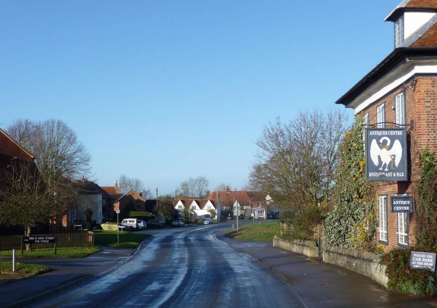
Table of Contents

       Topic                                                                     Page

1.     Introduction                                                                 2
2.     The Tetsworth Context                                                        5
3.     Vision and Objectives                                                        9
4.     The Evidence Base                                                           10
5.     Tetsworth Planning Policies and Action                                      17
              Policy TET1 Development within the Village Settlement and Surrounding 17
              Countryside

              Policy TET2 Settlement Character Areas and Design Criteria           18

              Policy TET3 Countryside Character Sectors                            19

              Policy TET4 Key Views                                                19

              Policy TET5 Local Heritage Assets                                    20

              Policy TET6 Landmark Buildings                                       21

              Policy TET7 Green Spaces                                             21

              Policy TET8 Biodiversity and the Natural Environment                 22

              Policy TET9 Residential Parking                                      22

              Action TET1 Community Infrastructure Levy                            23

              Tetsworth NDP Policies Map                                           24

Appendix A – 15 Key Views Report                                                  26

                                                                                 Page 1
Tetsworth Neighbourhood Development Plan – Referendum Version, March 2021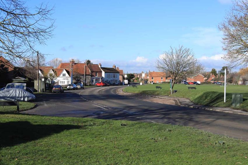
1. Introduction
What is a Neighbourhood Development Plan?
1.1 The Neighbourhood Planning system was introduced by the Localism Act 2011. Since its
introduction, local communities have been able to develop Neighbourhood Development Plans
(NDP) as part of a tiered approach to planning which aims to give local communities more say about
land-use and development in their area. The creation of a NDP is an opportunity for communities to
develop a shared vision for the neighbourhood and shape the development and growth of their local
area.
1.2 A NDP is a formal and positive plan for development which allows communities to shape the
local area in a way which suits their local needs. It can cover a single issue or a range of issues
depending on what is important to the community. Neighbourhood Planning allows communities to
work through their Parish Council to help identify, for example, the nature, extent and location of
future housing development, set out opportunities for improvements to community infrastructure,
facilities and services, and identify important features, both built and natural, that should be
protected.
1.3 Tetsworth Parish Council launched the Tetsworth NDP project in April 2016 authorising an
NDP Steering Group of volunteer residents to undertake the task of its preparation. The resulting
document sets out local planning policies which support the declared vision and objectives for the
future of the village and its surrounding countryside. Collectively, these policies will shape and direct
development within the Tetsworth Neighbourhood Area for the next 15 years.
1.4 The development of Tetsworth’s NDP is supported by a sound evidence base and wide-
ranging consultation with Tetsworth residents and others with a local interest. Details of the
consultation are recorded in a separate Consultation Document.
How a Neighbourhood Development Plan fits into the Planning System
1.5 NDPs come into force once they are approved at referendum. They become part of the
district’s development plan and are used to help determine development proposals in the
Neighbourhood Area. Before a NDP can be put to a referendum and be ‘made’, it must meet each of
a set of basic conditions. The Tetsworth NDP must therefore satisfy the following conditions:
Have regard to national policies and advice contained in guidance issued by the Secretary of
State.
Contribute to the achievement of sustainable development.
Be in general conformity with the strategic policies contained in the development plan for
the area of the authority.
Not breach, and otherwise be compatible with, EU obligations.
The Tetsworth Neighbourhood Area and Period of Validity
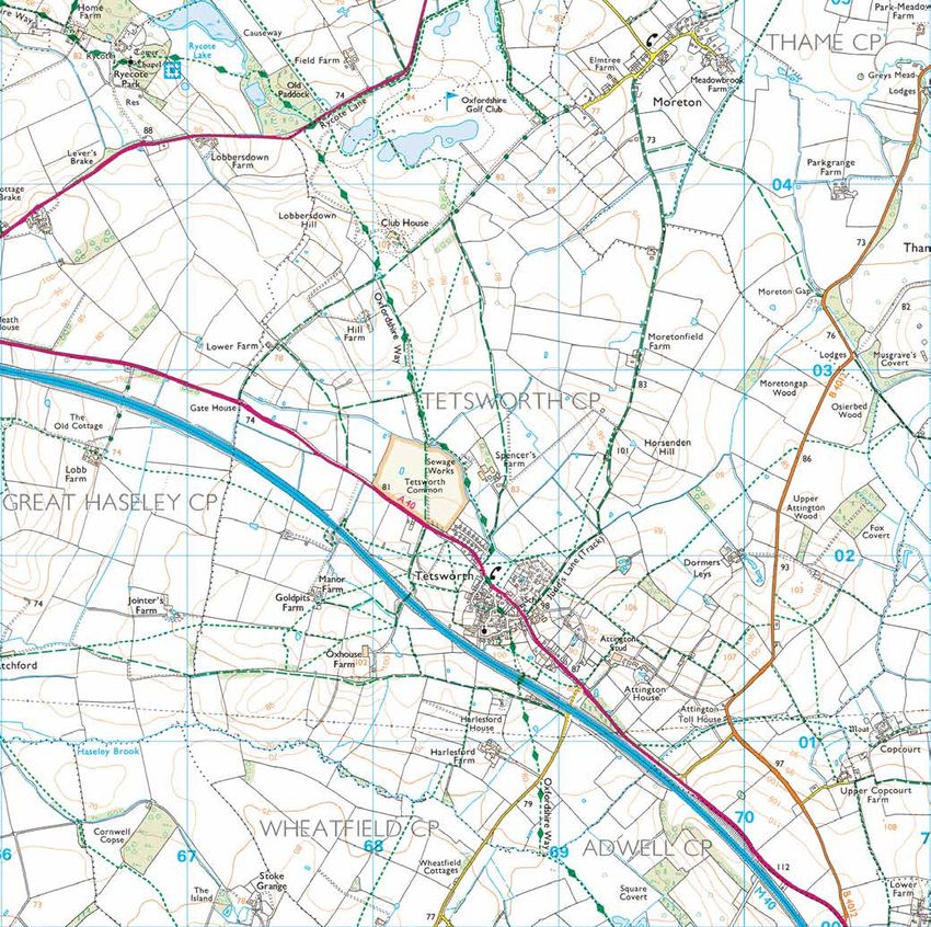
1.6 Following discussions with adjoining parishes, the Tetsworth Neighbourhood Area was
defined as the land enclosed within the Tetsworth Parish boundary. South Oxfordshire District
Council (SODC) confirmed this area designation on 1 June 2017 as shown on the map at Figure 1. The
Page 2
Tetsworth Neighbourhood Development Plan – Referendum Version, March 2021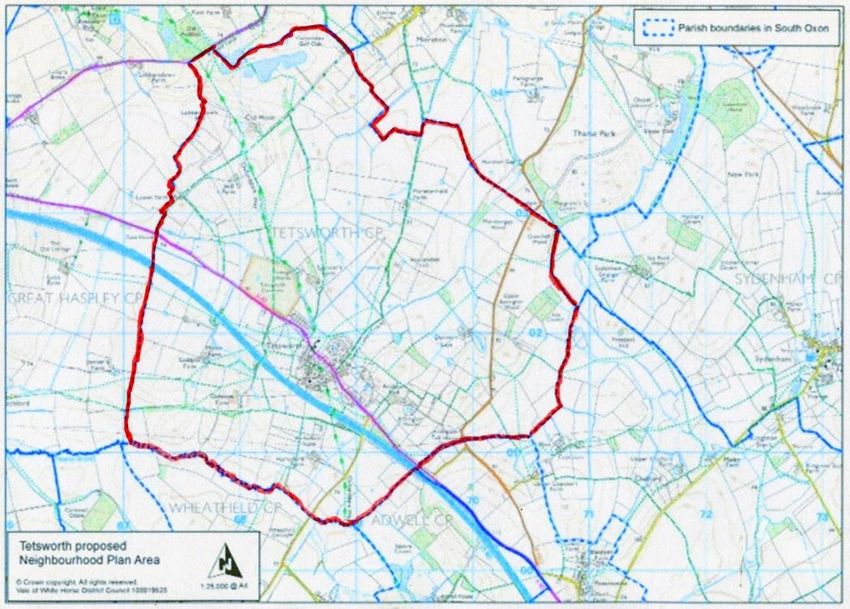
Tetsworth NDP will run for a 15 year period to 2035. This maintains full alignment with the 2011
start point and evidence base period supporting South Oxfordshire’s Local Plan 2035.

       Fig 1. Tetsworth Neighbourhood Area as Defined by the Tetsworth Parish Boundary

The SODC Policy Context
1.7      Tetsworth’s NDP has been prepared within the transitionary period between the operation
         of the South Oxfordshire Core Strategy and the South Oxfordshire Local Plan 2035.

1.8      The Local Plan was adopted in December 2020 and the Tetsworth NDP was examined against
         its policies.

The Tetsworth NDP Structure
1.9      Tetsworth NDP is divided into the following sections:

         Section 1.      Introduction
         Section 2.      The Tetsworth Context
         Section 3.      Vision and Objectives
         Section 4.      The Evidence Base
         Section 5.      Tetsworth Planning Policies and Action

The Evidence Base
1.10    The Tetsworth NDP draws on 2011 Census data to establish its baseline information for the
plan period. The objectives and policies in the Tetsworth NDP have been informed by a number of
focused studies and reports which define the character and status of Tetsworth Parish, and record

                                                                                              Page 3
Tetsworth Neighbourhood Development Plan – Referendum Version, March 2021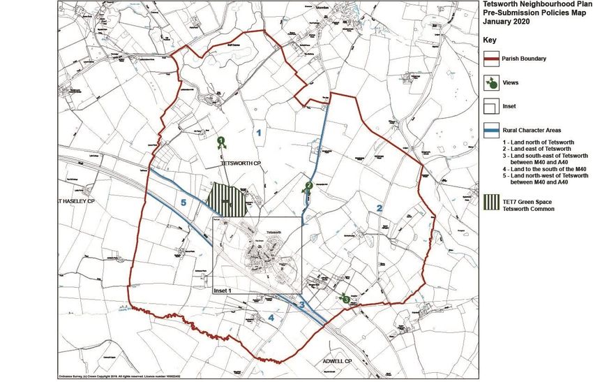
the opinions and wishes of local residents. Reports of these studies are available as the following
stand-alone documents and are summarised in Section 4 of the NDP:
Tetsworth Parish Character Assessment
15 Key Views Report
Tetsworth Housing Analysis
Tetsworth Sustainability Overview
Tetsworth Neighbourhood Plan Questionnaire Response Analysis
Page 4
Tetsworth Neighbourhood Development Plan – Referendum Version, March 2021
2       The Tetsworth Context
The Parish
2.1     This section of the Tetsworth NDP provides a brief description of the location, history and
more recent status of Tetsworth. It also sets out baseline data for Tetsworth recorded by the Office
for National Statistics in the 2011 Census – the starting point for the Tetsworth NDP.

Tetsworth’s Location
2.2       Tetsworth is located within South Oxfordshire and largely comprises a single, nucleated
village community near the centre of the area, surrounded by open countryside. As shown in Figure
2, Tetsworth lies approximately 15 miles east of the centre of Oxford and 4 miles south of the
market town of Thame. Aylesbury and High Wycombe are situated about 15 miles north-east and
south-east of the village respectively. Access to these towns is judged to be important by the
overwhelming majority of residents for reasons of employment and provision of services and
facilities.

                     Fig 2. Location of Tetsworth and Surrounding Major Towns

Parish Rural Setting
2.3       Tetsworth Parish has a predominantly rural agricultural setting. The village settlement lies
near the centre of the approximately circular Parish which has an area of just over 4 square miles.
The Parish boundary adjoins surrounding parishes in open countryside and the village enjoys
significant green gaps between it and other settlements or other significant developments. Although
often described as nestling below surrounding higher viewpoints, much of the older area of the
village is built on a hill with the church steeple being a visible landmark from most directions. The
Parish lies between the Oxford Green Belt to the west and the Chilterns Area of Outstanding Beauty

                                                                                               Page 5
Tetsworth Neighbourhood Development Plan – Referendum Version, March 2021
to the east. Although without formal landscape protection, the countryside within the Parish has
previously been described by planning inspectors as having landscape value in its own right.

Tetsworth’s History
2.4     Tetsworth probably has Anglo Saxon origins. Its name is believed to be made up of a
person's name, 'Taetel', and the common Anglo Saxon place name ending 'worth' meaning an
enclosure. It certainly existed as a settled community at the time of the Domesday Book, although it
was not mentioned in it. Tetsworth’s position at the crossroads of the main London-Oxford route
and a north-south roadway from Thame to Wallingford was recognised in the earliest known
printing of a map of England in 1382. Until the late 16th century, the land comprising Tetsworth was
controlled by either the church or crown in turn.

2.5     The village’s growth and prosperity has historically been heavily dependent on agricultural
employment, although it achieved some prominence as an important staging point during the
golden age of coach travel. There was a great deal of poverty in the early 19th century, but
comparative wealth and population growth to more than 500 by 1851. In part due to the spread of
railways elsewhere and fewer agricultural or other local employment opportunities, the 1931 census
recorded fewer than 300 Tetsworth residents and only about 100 households.

Although subject to post-war expansion, the village of Tetsworth has continued to be the sole
settlement within the Parish and its tightly nucleated footprint and village road pattern are still
easily recognisable from a century ago.

                             Fig 3. Tetsworth Village Settlement Footprint

                                                                                                  Page 6
Tetsworth Neighbourhood Development Plan – Referendum Version, March 2021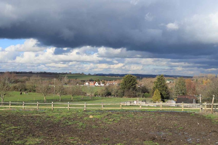
Tetsworth’s Enduring Heritage
2.6      Although the Parish does not have a Conservation Area, Tetsworth has 15 Listed Buildings
with the most prominent being The Swan, once a noted coaching inn, listed at Grade II* and St Giles
church with its landmark steeple. Most of the protected structures lie within the Tetsworth village
footprint. Three of the listed buildings were built as a result of the benevolence and foresight of the
Reverend John W Peers who was the vicar of Tetsworth from 1841 to 1876. During his tenure, he
oversaw the building of the current St Giles church and the Old Vicarage, the establishment of a
village school and laying of the network of attractive cobble village footpaths. His legacy has
contributed significantly to the character of Tetsworth and is still with us today. As well as its listed
assets, Tetsworth’s street-scene also continues to benefit greatly from the presence of a number of
Victorian or earlier dwellings of significant architectural merit located throughout the village core.
The history of the village is documented in more detail in the Tetsworth Parish Character
Assessment.

Tetsworth in 2011
2.7      By the time of the 2011 census, Tetsworth had grown to a population of 693 residents,
nearly a quarter of whom were under 20 years old, with another quarter older than 60. Compared
with the rest of South Oxfordshire, this age profile revealed a lower proportion of younger residents,
but the older quartile was broadly in line with the wider community. The Parish supported 278
households, the overwhelming majority of which lived in the village settlement as owner-occupiers
with just 20 or so dwellings situated elsewhere in the surrounding countryside. A further 16
dwellings, most of which were single bedroom flatlets in a sheltered accommodation block which
has subsequently been redeveloped, were unoccupied at the time of the census. The size of the
village and limited access to services, facilities and public transport place it firmly in the Smaller
Village category in SODC’s hierarchy of settlements. A significant infrastructure feature of the Parish
is the M40 motorway which has traversed the area and passed along the southern edge of the
village since 1974. An overhead electricity transmission line and two buried trunk gas pipelines are
also routed across open countryside in the Parish. More detailed coverage of such themes as
population, home ownership and what makes Tetsworth special is contained in the Tetsworth Parish
Character Assessment and Tetsworth Housing Analysis.

2.8      Post-war expansion of Tetsworth’s housing stock had been achieved through a small number
of significant housing projects each generating between 25 and 50 new homes, together with a
trickle of individual houses and smaller developments taking advantage of available infill sites within
the village. The most recently completed major development before 2011 was the building of the
Swan Gardens estate in the mid-1990s. Despite this expansion, Tetsworth maintained its tightly
nucleated footprint which was sufficiently compact to encourage walking and cycling as the
dominant modes of getting around the village.

Transport Infrastructure
2.9      Tetsworth enjoys ready access to the national road network with the A40 running through
the village and access to the adjacent M40 motorway available at Junctions 6 and 7 approximately 3
miles east and west of the village. Thame, the nearest Market Town, can be reached by car in under
10 minutes and journey times to Oxford, Aylesbury and High Wycombe are less than half-an-hour.
Public transport provision has now reduced to a single bus service running just four times a day on
weekdays between Oxford and High Wycombe; journey times to either terminus is approximately 40

                                                                                                   Page 7
Tetsworth Neighbourhood Development Plan – Referendum Version, March 2021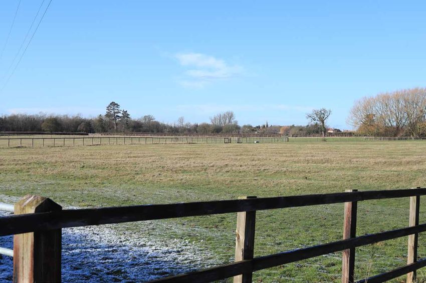
minutes and there is no evening or, until recently, a weekend service. A Saturday service was
introduced in September 2020.

2.10 Tetsworth is remote from the national rail network and the closest connection is at
Haddenham and Thame Parkway on The Chiltern Line. This station is 7 miles north of Tetsworth,
beyond Thame.

Living in the Parish
2.11 Tetsworth is not well endowed with facilities and services with residents relying, almost
exclusively, on travelling to Thame or further afield for health, secondary education, and virtually all
business and retail needs. It is notable that Thame’s own infrastructure and services are already
under increasing pressure due to the town’s own rapid new housing and population growth.

2.12 Two thirds of residents in paid employment commute out of the village on a daily basis while
half of the remainder operate businesses from their home addresses. Almost all who commute, do
so by car and approximately three-quarters of those who work outside the village travel at least 10
miles, with a significant proportion commuting at least 30 miles. The close access to the M40 is a
clear benefit for many commuters, but the down-side of its proximity is the never-ending motorway
noise affecting all Tetsworth residents. Unemployment in the Parish is low with only around 1% of
working age residents receiving Jobseeker’s Allowance.

2.13 The dominant reasons stated by families for becoming residents of Tetsworth are that ‘it is a
nice place to live’ and that ‘a suitable home was available’. These views are reinforced by the
reported principal attractions of living in Tetsworth which are led by its ‘rural location and lifestyle‘,
‘ease of access to the countryside’ and ‘feeling part of the community’. The majority of village
residents wish to see a very modest rate of growth over the future planning period with Tetsworth
remaining ‘a rural community where people both live and work’ and being ‘little changed from
2017’.

2.14    An issue that Tetsworth shares with other residents of Oxfordshire is the affordability of
housing. Despite the majority of its residents enjoying a relatively affluent lifestyle, the housing
affordability gap in Tetsworth is a concern and was assessed in 2018 to average £250,000 and may
be as much as £125,000 even for less expensive, smaller dwellings. This issue was examined in the
Tetsworth Housing Analysis report and Land Registry data for 2016/2017 show that the average
purchase price of homes in Tetsworth was approximately £550,000 compared with £400,000 for
Oxfordshire and £290,000 for the rest of the country.

                                                                                                   Page 8
Tetsworth Neighbourhood Development Plan – Referendum Version, March 2021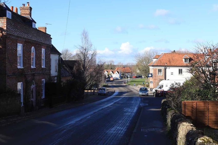
3        Vision and Objectives
3.1      The Vision statement for Tetsworth’s future development reflects the broad wishes of the
community to accept a modest rate of change and growth while preserving its essential character as
a rural village settlement. Much of this can be delivered within the higher-level planning policies of
the National Planning Policy Framework (NPPF) and the policies in the South Oxfordshire Local Plan
2035. Therefore, Tetsworth NDP’s Objectives, and its Policies to achieve them, focus on the priorities
of ‘what makes Tetsworth special’.

3.2      The Vision and Objectives of Tetsworth’s NDP are:

Vision

 Vision
          To sustain Tetsworth as an inclusive, rural community where residents want to
          live, to maintain its attractiveness and to look to an active and vibrant future.

Objectives

 Objective 1
          To maintain Tetsworth’s nucleated settlement character by supporting a mix of
          high quality infill housing that reflects the housing types and tenures which
          satisfies the local community housing need and is in proportion with the size
          and rural character of the Parish.
 Objective 2
          To preserve the green spaces within and adjacent to the Tetsworth village
          settlement and the key views into and from its built-up area.
 Objective 3
          To protect and enhance Tetsworth’s heritage assets and their settings.
 Objective 4
          To protect the rural landscape character and setting of Tetsworth while
          supporting and enhancing local amenities and environmental assets.
 Objective 5
          To maintain and enhance wildlife habitats and biodiversity in the Parish.
 Objective 6
          To identify and support service improvements and infrastructure initiatives
          which could enhance the sustainability of Tetsworth and wellbeing of its
          residents.

                                                                                               Page 9
Tetsworth Neighbourhood Development Plan – Referendum Version, March 2021
4 The Evidence Base
4.1 Studies specifically undertaken to inform the preparation of the Vision, Objectives and
Policies within the Tetsworth NDP were listed in Section 1. The associated reports are published as
stand-alone documents, but are summarised here in Section 4. In addition, Policies in the Tetsworth
NDP take note of relevant data in the South Oxfordshire Local Plan 2035 plans and on the following
topics published by specialist organisations and agencies
Protected species and habitats – Thames Valley Environmental Records
Agricultural land classification – Natural England
Heritage assets – Historic England
Flood risk – Environment Agency
4.2 2011 Census data from the Office for National Statistics and the later Community Insight
Report for the Tetsworth Area issued in January 2018 both provided helpful official external sources
of information on Tetsworth’s demographics and social and economic status.
Tetsworth Parish Character Assessment
4.3 This study provided a detailed picture of Tetsworth in six defined areas of the village
settlement and a more generic description of the five radiating countryside sectors surrounding the
village. The aim of addressing built-up and rural areas separately was to acknowledge that different
planning policies may be applied in the different environments. Each of the village’s Settlement Area
assessments covers such aspects as housing type and design, the streetscape, notable heritage and
community assets, green and public open spaces and valued settings. The six village Settlement
Areas are shown in Figure 4.
Figure 4. Tetsworth Village Character Areas.
Page 10
Tetsworth Neighbourhood Development Plan – Referendum Version, March 2021Village Historic Core This area contains the majority of Tetsworth heritage assets, is
characterised by its long-standing network of narrow roads and its attractive housing mix of
individual designs and various ages. More than any other area, it is what makes Tetsworth
special and has only limited capacity for further infill development.
Marsh End and High Street West This area comprises the limited ribbon development of
individually-designed housing largely along the southern side of High Street and the post-
war development of Marsh End originally built as template social housing, but now
exhibiting greater individuality with changes incorporated by owner-occupiers.
Village Green This open green space at the heart of the village is highly valued by
residents as a focus for sports activities and other community social and leisure events. It
also includes a recently refurbished children’s play area and an outdoor learning centre. Its
attractive setting and status merit protection from development.
Swan Gardens Estate This 1990s development of over 40 dwellings with a single access
from the High Street is dominated by large ‘pattern book’ executive residences but also
includes some smaller terraces of affordable homes. The overall design of the area has left
few opportunities for further development.
The Grange Estate (Now Blackthorn Rise) A development site at Mount Hill Farm has
recently been transformed into a new 39 dwelling housing estate with a single access to the
High Street. The development build-phase was completed in October 2020 and the estate is
now named Blackthorn Rise. The development has delivered a modern mix of market and
affordable homes.
High Street East This area features limited ribbon development of housing largely of
individual designs and various ages facing both sides of the High Street from its eastern entry
into the village.
4.4 The five Countryside Sectors surrounding the village are shown in Figure 5. The two large
areas to the north of the A40 are separated by Judds Lane, a byway running northwards from the
village towards Moreton and Thame. Two further Sectors cover the open countryside between the
A40 and M40 highways to the east and west of the village settlement with remaining Sector covering
all land to the south of the M40.
Page 11
Tetsworth Neighbourhood Development Plan – Referendum Version, March 2021Figure 5. Tetsworth Parish Rural Character Sectors.
4.5 Although each Countryside Sector contains its own unique rural features, a common theme
is the attractive rolling landscape of the clay vale and timeless farming activity across a long-
established field pattern defined by mature hedgerows. These, individual native trees and field
margins provide much-valued wildlife habitats for many bird species in decline. The local countryside
has been particularly successful in supporting a growing population of red kites. Most of the
agricultural holdings support varied livestock grazing while others dedicate some of their fields to
arable cropping. Just beyond the north-eastern edge of the Parish, Thame Park has been designated
as a Conservation Target Area. The only significant development in the open countryside is the
Oxfordshire Golf Course and Spa which extends beyond the northern edge of the Parish. Another
notable feature of Tetsworth’s surrounding countryside is the unusually extensive network of public
footpaths and rights-of-way which include the nationally-recognised Oxfordshire Way. Together,
these footpaths and byways give much-appreciated amenity access for walkers, runners and cyclists
to open spaces and undeveloped countryside from the edge of village. The value of key views of,
from and within the village is of such significance that it was the subject of a separate Key Views
study and report.
4.6 Tetsworth residents enjoy many public amenity spaces within the village itself including the
Village Green, Jitty, Pound, War Memorial setting and allotments, as well as the extensive network
of bridleways and paths radiating through the village into the surrounding open countryside. The
Parish Council also has responsibility for a small allotment site and the care of 18 trees which are
subject to Tree Preservation Orders. Tetsworth Common adjoins the north-west edge of the village
settlement and is also adjacent to the Oxfordshire Way and a valued green space. Grazing rights over
this land have been granted to a local farmer.
Page 12
Tetsworth Neighbourhood Development Plan – Referendum Version, March 202115 Key Views Report
4.7 The importance of preserving, as far as possible, the attractive views into, within and from
the Tetsworth village settlement is documented in this report. All of the views are from publicly-
accessible viewpoints and reflect the aesthetically attractive sense of place of the village and its
hinterland. Many of the inwards views from footpaths or other rights-of-way on higher ground,
including the Oxfordshire Way, feature Tetsworth’s landmark church steeple or frame the attractive
nestled setting of the village. Valued views in the village itself focus on sight-lines of and beyond the
Village Green. Outward views of the countryside emphasise the rural character of the Tetsworth
community.
Tetsworth Housing Analysis
4.8. This study documents Tetsworth’s housing stock of 294 dwellings by type, size and tenure as
it stood at the 2011 Census. However, its main purpose is to establish the nature and extent of
housing growth which has been achieved since 2011 and the potential for future sustainable
development. It assesses this against the expected growth targets for Smaller Villages set out in the
South Oxfordshire Local Plan 2035 Policy H8 and considers the potential impact this would have on
housing supply. The study also reports the views of residents on the extent, type and location of any
additional housing. The highest level of support was for houses with 3 or fewer bedrooms, hinting at
the affordability gap facing would-be Tetsworth residents.
4.9 Nearly half of the local housing stock is detached houses or bungalows, approximately a
third is semi-detached dwellings with the remainder split between terraced homes and
flats/apartments. At the time of the census, over three-quarters of households lived in privately
owned properties with or without a mortgage while the remainder relied on the social or private
rental sector. More recent questionnaire responses suggest that owner-occupation is now
approaching 85%. Once established in Tetsworth, families tend to stay here for a long time,
approximately 60% having been residents for more than 10 years.
4.10 By 2019, 68 new dwellings had already been delivered or have planning permission over and
above the 2011 census baseline. A major element of this growth is the significant development of an
estate of 39 new dwellings on a site at Mount Hill Farm, known as The Grange and now named
Blackthorn Rise. The approved developments therefore already represent growth of nearly 20%
from the baseline figure. This is nearly double the upper growth expectation in Policy H8 for Smaller
Villages in the South Oxfordshire Local Plan 2035, and is consistent with Policy H16 which limits
housing growth in Smaller Villages to infill developments and the redevelopment of previously
developed land or buildings.
4.11 Against this background, SODC’s call for potential development sites resulted in the
registration on its Housing and Economic Land Availability Assessment (HELAA) database of a
number of sites surrounding the Tetsworth village settlement and included part of the land
proposed for the creation of a new strategic settlement known as Harrington. These sites are shown
in Figure 6.
Page 13
Tetsworth Neighbourhood Development Plan – Referendum Version, March 2021Figure 6. SODC’s HELAA Data for Tetsworth
To date, one infill site has delivered 4 new dwellings and the 39 new dwellings at Mount Hill Farm is
now complete. The dominant Harrington strategic site proposal shown in Figure 7 has not been
included in the adopted South Oxfordshire Local Plan 2035.
4.12 Irrespective of the Harrington proposal’s future status, if the chosen route of the planned
Oxford-Cambridge Expressway route was to pass east of Wheatley, it could result in significant
housing development being proposed in the green gap between Tetsworth and Milton Common.
Page 14
Tetsworth Neighbourhood Development Plan – Referendum Version, March 2021Figure 7. Harrington Potential Development Site Plan
4.13 The Tetsworth Housing Analysis report concludes that the village has already more than
fulfilled its identified housing requirements, including affordable housing provision, for the period.
The village’s status as a Smaller Village indicates that future housing growth should be limited to
infill proposals. Accordingly, no Site Allocations have been made within the Tetsworth NDP.
4.14 Finally, the report recognises the affordability challenge facing individuals and families
wishing to buy or rent homes in the village. Therefore, it seeks to encourage proposers of future
housing developments to address this issue by bringing forward designs for more financially
accessible dwellings. This could be achieved by supporting infill and redevelopment proposals for
starter homes and smaller homes suitable for downsizing and retirement living.
Tetsworth Sustainability Overview
4.15 Like many small rural settlements, Tetsworth no longer enjoys the services of a village post
office or a broad range of retail outlets, but continues to support the essential pillars of a village
community. Tetsworth Memorial Hall, St Giles Church, Tetsworth Sports & Social Club, the Village
Green and its PATCH play area and sports teams collectively represent the principal community
assets that support village social life. All are judged to be very important local amenities by the
majority of residents. The Old Red Lion public house which also supports a small village store and
The Swan restaurant are both valued commercial amenities attracting their own loyal clientele.
4.16 Tetsworth Primary School is an important community asset providing pre-school and
primary education for local children and is popular with parents. In May 2019, the school was
oversubscribed with 60 primary-aged pupils against its nominal capacity of 56. There are also 15
part-time equivalent nursery places. A future increase in the school’s capacity is planned under a
Section 106 obligation from the Mount Hill Farm housing development now known as The Grange.
Page 15
Tetsworth Neighbourhood Development Plan – Referendum Version, March 2021Children must travel to schools in Thame, Wheatley, Watlington or further afield for secondary
education.
4.17 Above average car ownership, at 2 cars per household, is a reflection of the paucity of public
transport services and local employment opportunities, and ready access to a well-developed road
network connecting with more active centres of business and employment. Local unemployment is
low, and the proportion of self-employed residents amongst the economically active is much higher
than District and National levels. Significant local business ventures include the Oxfordshire Golf
Club, Hotel & Spa, the Zioxi educational furniture plant, the Swan antiques centre and restaurant,
and a number of neighbouring equestrian and agricultural enterprises. A proportion of residents also
operate a range of generally home-based domestic and professional service businesses. However,
most of those in employment commute out of the village to work.
4.18 Overall, the paucity of village facilities and public transport is reflected in Tetsworth scoring
just 38 points in a range of 19 - 70 in SODC’s assessment of these attributes for Smaller Villages in its
Settlement Assessment published in November 2018. Residents accept that relying on Thame or
other towns for virtually all their business and service needs is an acceptable feature of living in
Tetsworth.
Tetsworth NDP Questionnaire Response Analysis
4.19 A wide-ranging questionnaire seeking Tetsworth residents’ opinions of life in the village and
their aspirations for its future was conducted during May 2017. 273 residents, approximately 50% of
the adult population of Tetsworth, submitted responses to the questionnaire. The survey covered
the following subject areas:
Resident Profile
Living in Tetsworth
Use of Land
Housing Development
Infrastructure and Environment
Possible ‘New Town' Development
The Future of Tetsworth
Employment and Business
The findings built on and superseded residents’ opinions recorded in a similar survey conducted in
2014 to support the development of the Tetsworth Community-Led Plan 2015-2025.
4.20 The general themes of responses showed the strongest support for improvements in
community infrastructure and services while preserving the size and character of the village and
countryside much as it is today. Only a minority was in favour of significant new housing
development and there was very little appetite for commercial or industrial development. The
feedback provided valuable information in framing the Vision, Objectives and Policies which should
be included in the Tetsworth NDP. These views were also taken into account in the preparation of
the Character, Housing and Sustainability aspects of the Evidence Base.
Page 16
Tetsworth Neighbourhood Development Plan – Referendum Version, March 20215 Tetsworth Planning Policies and Action
The Policy Context
5.1 The following Policies in Tetsworth’s NDP have been guided by its Vision and Objectives in
Section 3 and supported by the findings of the Evidence Studies summarised in Section 4. The
policies are illustrated in the Policies Map and Inset at Figures 8 and 9.
Policy TET1: Development within the Tetsworth Village Settlement and
Surrounding Countryside
Proposals for small scale, infill development within the village settlement will be
supported, provided they accord with the design and development management
policies of the South Oxfordshire Local Plan 2035 and any other relevant policies of
this Neighbourhood Plan.
Proposals for development outside the village settlement will only be supported if
they are appropriate to a countryside location and are consistent with South
Oxfordshire Local Plan 2035 and any other relevant policies of this Neighbourhood
Plan.
5.2 This policy is intended to distinguish between supported development within the built-up
area of the village and its surrounding countryside in order to manage development proposals
accordingly. The village settlement is not defined by a formal boundary but is, essentially, land
within the observed settlement edge formed by buildings which have a clear functional relationship
to the village. This area also reflects plot boundaries where they are clearly defined in the street-
scene or within the landscape, e.g. mature trees/hedges, boundary walls/fences. Features that
appear visually as part of the open landscape – roads, waterways, large open gardens with no/few
built structures – are excluded from the settlement footprint, irrespective of their functional
relationship to land within the village settlement.
5.3 Most new development will be acceptable in principle within the village settlement, subject
to it being appropriate in terms of its design, compliance with adopted Local Plan policies and
Tetsworth’s status as a Smaller Village in the District’s settlement hierarchy. This may be small scale,
infill housing and other uses that are appropriate in scale to a reasonably remote Smaller Village
with limited public transport services. Policies H8 (Housing in the Smaller Villages) and H16 (Infill
development and redevelopment) of the Local Plan set the context for the scale and nature of new
development which would be supported in smaller villages. Policy H16 specifies that new residential
development should be limited to infill and the redevelopment of previously developed land or
buildings. It also provides specific criteria-based guidance for any new residential development
which would be located behind existing frontages or which would involve additional dwellings within
an existing site. As property prices in Tetsworth are far higher than average, proposals for less
expensive dwellings will be encouraged. This could be achieved by supporting infill and
redevelopment proposals for smaller homes with 3 or fewer bedrooms, starter homes and houses
designed for downsized retiree ownership.
5.4 The policy requires that development proposals outside the village settlement are in line
with the relevant policies of the adopted Local Plan and Tetsworth NDP in respect of protecting local
Page 17
Tetsworth Neighbourhood Development Plan – Referendum Version, March 2021landscape character and character of the natural environment. The policies recognize the valued
function of the countryside and working farmland in shaping rural character. Only land uses that are
appropriate for a countryside location will be supported.
5.5 Tetsworth’s NDP does not make any housing site allocations as Tetsworth has, since the
2011 census, already accepted additional housing well in excess of growth expectations in SODC’s
existing and emerging housing policy for Smaller Villages. SODC has confirmed that the ‘indicative
housing figure’ for Tetsworth, as per Para 66 of the NPPF, is zero.
Policy TET2: Settlement Character Areas and Design Criteria
The village of Tetsworth is the single nucleated settlement within the Neighbourhood
Area, and the Neighbourhood Plan defines Settlement Character Areas on the
Policies Map.
Development proposals in a Settlement Character Area will be supported if they
demonstrate that the positive features identified relating to that Area in the
Neighbourhood Plan Character Assessment and guidance in the South Oxfordshire
Design Guide have been incorporated into the design of the development.
As appropriate to their scale, nature and location, development proposals should:
Demonstrate that the size, location and character of gardens and outdoor
amenity spaces have been considered as an integral part of the design;
Seek to satisfy technical space standards for commercial property converted
for domestic use;
Promote environmental sustainability design features, to conserve and
enhance natural resources and to prevent environmental pollution;
Encourage building techniques and methodologies, selecting sustainably
sourced materials to promote the sustainability of the dwelling;
Respect and enhance the character of identified heritage assets and their
settings;
Encourage use of traditional and vernacular building materials which respect
the character and setting of the development;
Ensure the proposed development does not result in unacceptable adverse
impact on the amenities of adjacent residential properties;
Require the design of on-plot residential parking spaces to reflect the local
character and not detract from the street scene;
Ensure, where possible, the proposed development does not adversely affect
the free and safe flow of traffic on the local highway network and is in
accordance with Para 109 of the NPPF;
5.6 This policy complements Policy TET1 by requiring land use proposals that are suitable in
principle within the village settlement to understand and respond to the Character Assessment in
Page 18
Tetsworth Neighbourhood Development Plan – Referendum Version, March 2021order that their design is also suitable to the specific character of the Area within which it is located.
The South Oxfordshire Design Guide also contains generic guidance on how design in villages should
be approached successfully.
5.7 The Character Assessment acknowledges that the village is not uniform in its character and
therefore defines six distinct Settlement Character Areas. For each Area it describes the overall
character, layout, topography, spaces, connectivity (roads, footpaths etc), natural features,
landmarks, common building characteristics and key views, some of which are addressed specifically
by other policies in this Plan. It is expected that applicants will set out in their proposals (in their
Design & Access Statements, where required, or elsewhere in their applications) how their proposals
accord with the guidance or justify why a departure from that guidance is necessary.
Policy TET3: Countryside Character Sectors
The Neighbourhood Plan defines Countryside Character Sectors on the Policies Map.
Development proposals in a Countryside Character Sector should preserve or enhance
the character and appearance in accordance with the positive features identified within
that Sector in the Neighbourhood Plan Character Assessment and guidance in the South
Oxfordshire Design Guide.
Any proposed development in a Countryside Character Area should also satisfy the
design criteria set out in policy TET2.
5.8 This policy complements Policy TET1 by requiring land use proposals that are suitable in
principle to a countryside location to understand and respond to the Character Assessment in order
that their design is also suitable to the specific landscape character of the Sector within which it is
located. The South Oxfordshire Design Guide also contains generic guidance on how design in the
countryside should be approached successfully.
5.9 The Character Assessment acknowledges that the countryside in the Parish is not uniform in
character and therefore defines five distinct Countryside Character Sectors. For each Sector it
describes the overall character, land form, topography, spaces, connectivity (roads, footpaths etc),
natural features, landmarks, common building characteristics and key views, some of which are
addressed specifically by other policies in this Plan. It is expected that applicants will set out in their
proposals (in their Design & Access Statements, where required, or elsewhere in their applications)
how their proposals accord with the guidance or justify why a departure from that guidance is
necessary.
Policy TET4: Key Views
The Neighbourhood Plan identifies Key Views on the Policies Map as valued sightlines
into and out of the village. Development should preserve or enhance the local character
of the landscape and not have an unacceptable adverse impact on the important views
5.10 This policy, and the Policies Map, identifies a series of views from public vantage points in
and beyond the edge of the village that are considered in the Neighbourhood Plan Key Views report
Page 19
Tetsworth Neighbourhood Development Plan – Referendum Version, March 2021(March 2019) as especially important in defining the special character of the village and its rural
hinterland. The 15 Key Views Report is reproduced in Appendix A of the Plan.
5.11 These views are particularly distinctive of the rural landscape setting, with the village lying
low within it but with long views into the countryside. The policy does not seek to prevent any
development lying within a view but requires that proposals recognise and take account of these in
their design. In each case, only the minimum area of land necessary to define the view has been
identified.
Policy TET5: Local Heritage Assets
In addition to the nationally-recognised Listed Buildings, the Neighbourhood Plan
identifies the following Local Heritage Assets:
1. Old Red Lion Public House;
2. Tetsworth War Memorial;
3. Mount Hill Farmhouse;
4. The Old School;
5. Falklands Villa;
6. The Victorian Congregational Chapel;
7. Harlesford House.
8. Tetsworth Cobble Footpaths
Development proposals that contribute to the conservation of a local heritage
asset in a manner appropriate to its significance will be supported.
Proposals for development affecting any of these local heritage assets should be
accompanied by an assessment of their significance and a description of the
means employed to avoid or minimise harm to them to a level of detail justified by
the nature of those effects and the significance of the asset. Any harm that
cannot be avoided should be robustly justified by the delivery of public benefits
that could not otherwise be delivered, taking into account the scale of any harm
or loss and the significance of the asset.
5.12 This policy, based on Historic England guidance, identifies a number of buildings and
structures in the Parish that, whilst not designated as listed buildings, are assessed as having local
heritage value through a combination of their age, distinctive architectural and aesthetic merit
within the Parish or a historical association with people or events. Their specific value is described in
the Tetsworth Parish Character Assessment. The listed buildings in the Parish, and their settings,
already benefit from statutory protection in the planning system and are therefore not included
here. Additionally, the Oxfordshire History Centre has recorded excavation a number of
archaeologically significant sites on the southern edge of Tetsworth which were investigated ahead
of the construction of the M40 motorway.
5.13 Policy ENV6 of the South Oxfordshire Local Plan 2035 also addresses this matter. Both
policies are complementary to the provisions of Para 197 of the NPPF in respect of non-designated
heritage assets. At present, the District Council does not maintain a list of such assets.
Page 20
Tetsworth Neighbourhood Development Plan – Referendum Version, March 2021Policy TET6: Landmark Buildings
The Neighbourhood Plan identifies the following Landmark Buildings:
1. Tetsworth Memorial Hall;
2. Tetsworth Sports & Social Club Pavilion;
3. Oxfordshire Golf Club and Spa (including stone entrance gateway);
Development proposals to extend or redevelop a locally significant Landmark Building
should preserve or enhance the role it performs in defining the character of that part of
the village and/or countryside.
5.14 This policy identifies a number of buildings and structures in the Parish that, whilst not
designated as Listed Buildings or Local Heritage Assets, occupy a prominent location in the village or
countryside and thus contribute to its character and the sense of place. Their specific value is
described in the Neighbourhood Plan Character Assessment.
5.15 This policy will operate alongside Policy DES1 of the adopted Local Plan. Proposals to extend
or to redevelop a prominent building must seek to avoid compromising the role it plays by way of its
building line, height or group value with other buildings.
Policy TET7: Green and Public Open Spaces
The Neighbourhood Plan identifies the following as Public Open Spaces within the village
settlement, as shown on the Policies Map:
1. Tetsworth Village Green;
2. The Jitty;
3. The Pound;
4. Village Allotments;
5. Forest School Outdoor Learning Centre;
Development within a Public Open Space should preserve and where possible enhance public
access and the contribution of the site to the health and well-being of visitors and residents.
Development proposals which would result in the loss of an identified public open space will
only be supported where:
Alternative provision of the public open space in an accessible location is secured as
part of the development proposal; or
It can be demonstrated that the open space concerned is surplus to requirements
5.16 Policy TET7 sets out the Plan’s approach to open spaces. It recognises their importance to
the local community and to the fabric of the settlement.
Page 21
Tetsworth Neighbourhood Development Plan – Referendum Version, March 20215.17 The policy identifies five Public Open Spaces that, whilst not meeting the tests to be
designated as Local Green Spaces, are still worthy of protection from harmful development. The
policy therefore requires that any development proposals are of a scale that does not undermine
their character and of a type that does not undermine public access and enjoyment of the spaces.
Judd’s Lane also has major historic significance for Tetsworth. As long ago as the 11th century, it
formed part of a north-south roadway from Thame to Wallingford crossing the east-west London to
Oxford highway at a location which defined the initial establishment of the Tetsworth village
settlement. Its transport significance diminished over the centuries until it became designated as a
public bridleway only suitable for horses, walkers and cyclists, and providing access for farmers and
residents of the handful of dwellings on the route. It is not identified as a public open space as it is a
highway and its use is controlled by separate legislation. Nevertheless, the Parish Council will work
with others to ensure that its tranquillity is safeguarded throughout the Plan period.
Policy TET8 – Biodiversity and the Natural Environment
Development proposals should ensure that existing wildlife habitats are not unacceptably
affected, and that existing green and blue infrastructure are preserved and where practicable
enhanced (including providing net gains in biodiversity).
As appropriate to their scale, nature and location development proposals should take account
of the relevant geographic area of the Tetsworth Parish Character Assessment.
5.18 This policy identifies a series of development principles that relate to specific green
infrastructure opportunities and constraints in the Parish so that development proposals can
address green infrastructure, and especially biodiversity, matters as relevant to the nature and scale
of the proposal. Not all of these principles will be relevant to each proposal. For the most part, they
can be dealt with as part of the proposed landscape scheme as a means of ensuring any potentially
harmful effects of the development can be satisfactorily mitigated.
Policy TET9 - Residential Parking
New residential development (including extensions) that gives rise to the need for
additional parking for residents and visitors will be supported only where adequate
parking provision is made in line with the Oxfordshire County Council parking
standards.
All new residential developments should be associated with the provision of appropriate
dedicated on-site parking solutions for each dwelling. Where such parking solutions are not
practicable or are otherwise inappropriate, planning proposals should set out reasonable
alternative provision such as communal parking areas, garage blocks or parking bays.
5.19 Tetsworth already suffers from a chronic shortage of on-street parking capacity. It is
therefore particularly important that new dwellings do not add to this problem.
Page 22
Tetsworth Neighbourhood Development Plan – Referendum Version, March 2021Action TET1 - Community Infrastructure Levy
Tetsworth Parish Council will consult village residents on potential CIL-funded projects
to be included in its candidate list and their prioritisation.
5.20. The majority of residential and commercial building projects now attracts the liability on
developers to pay a Community Infrastructure Levy. Once Tetsworth’s NDP is ‘made’, 25% of the
proceeds of the levy from local building projects will be made available for spending by Tetsworth
Parish Council. The Community Infrastructure Levy receipts from small infill developments will not
be sufficient to fund major infrastructure improvements, but do have the potential to support more
modest improvements for the benefit of the Tetsworth community. A number of potential
infrastructure improvement projects were identified within the Tetsworth Community-Led Plan
2015-2025 and others have subsequently come to light. Examples include additions to the PATCH
play area, implementation of road safety measures, refurbishment projects in Tetsworth Memorial
Hall and Tetsworth Primary School enhancements.
5.21. Creation and maintenance of a prioritised list of potential local projects which would benefit
from Community Infrastructure Levy spending is the responsibility of Tetsworth Parish Council. This
Plan requires the Council to consult residents on the inclusion and prioritisation of projects in its
candidate list.
Page 23
Tetsworth Neighbourhood Development Plan – Referendum Version, March 2021Tetsworth NDP Policies Map
Figure 8. Tetsworth NDP Policies Map
Page 24
Tetsworth Neighbourhood Development Plan – Referendum Version, March 2021Figure 9. Tetsworth NDP Policies Map Inset
Page 25
Tetsworth Neighbourhood Development Plan – Referendum Version, March 2021Appendix A – 15 Key Views Report
Page 26
Tetsworth Neighbourhood Development Plan – Referendum Version, March 2021A description of
15 Key Views
Supporting evidence for the
Tetsworth Neighbourhood Plan
Prepared for
Tetsworth Parish Council
March 2019
Company Registration No. 09809868
Registered Office: 35 Pickford Road Bexleyheath DA7 4AGPrepared by: John Jeffcock
Position Associate Landscape Architect
Qualifications: CMLI, Reg. NZILA, MLA, BA (Hons) LA
Reviewed by: Michelle Bolger
Position: Director I Landscape Architect
Qualifications: CMLI, Dip. LA, BA (Hons) LA, PGCE, BA (Hons) Eng
File name: 1083 R01 Key Views Tetsworth Final.docx
Date issued: 6 March 2019
Status: Final
Revision: 1
1083 R01 Key Views Tetsworth Final.docxCONTENTS
1 Introduction 1
2 Landscape Context 3
3 Tetsworth’s Key Views 6
Appendix 1 Figures
Appendix 2 Key Characteristics Identified Within Published Landscape Character Assessments
Appendix 3 Valued Characteristics Summary Table
1083 R01 Key Views Tetsworth Final.docx1
1 Introduction
1.1 Introduction
Tetsworth Parish Council (TPC) commissioned Michelle Bolger Expert Landscape
Consultancy (MBELC) to provide photography and written descriptions of 15 Key Views to
support the emerging Tetsworth Neighbourhood Development Plan (NDP).
For the purposes of this study a Key View is defined as a view which allows Tetsworth’s
valued characteristics to be most easily appreciated. The views are all from easily
accessible public locations. These views contribute positively to Tetsworth’s unique
character and sense of place.
1.2 Background & Purpose
TPC and a NDP Steering Group are currently in the process of writing their NDP. The
Tetsworth Neighbourhood Area – which aligns with the Parish boundary - was formally
designated on 1 June 2017 (Figure 1, Appendix 1).
A number of views were identified by the NDP Steering Group prior to MBELC’s
commission.1 In August 2018, MBELC met with representatives of TPC and the NDP Steering
Group to discuss how these views had been identified. Following that meeting it was
agreed that MBELC would review the views already identified and describe those with the
greatest importance. 15 views have been taken forward for description in this report.
This report forms part of the NDP evidence base. It complements the emerging Tetsworth
Parish Character Assessment and supports the NDP’s environmental policies. It is
anticipated that future development proposals will respect these views and enhance them
wherever possible. In this way the identification of Key Views will help to conserve
Tetsworth’s character and sense of place.
1
Identified within Draft Tetsworth Parish Landscape Character Assessment, April 2018, V9.
1083 R01 Key Views Tetsworth Final.docx2
This report has been informed by:
• published landscape character assessments;
• designations;
• the South Oxfordshire Development Plan;
• MBELC’s existing familiarity with Tetsworth; and
• a project-specific visit undertaken on the 30th January 2019.
1.3 Relevant Guidance
This report has been prepared by Chartered Members of the Landscape Institute (CMLI). It
has been completed with reference to guidance, including: An Approach to Landscape
Character Assessment (2014), Natural England; and Photography and Photomontage in
Landscape and Visual Assessment, Advice Note 01/11 (2011), Landscape Institute.
1083 R01 Key Views Tetsworth Final.docx3
2 Landscape Context
2.1 Local Landscape Character
Tetsworth is located in South Oxfordshire District about 5 miles south of Thame and 15
miles south-east of Oxford. The village is located on a hill. St Giles Church is located at
the highest point and forms a prominent landmark across the Parish. From the village land
can be seen rising higher to the north-west (Lobbersdown Hill), to the north-east
(Horsenden Hill) and to the east. Another high point is found to the south at Oxhouse
Farm. Beyond this to the south and east the land falls but rises again, particularly to the
east around Stoke Talmage.
Tetsworth has remained a relatively compact village despite some intensification of
development, particularly during the 20th C. More recently (2016) permission was granted
for a development of 39 houses north of the High Street (Mount Hill Farm) replacing in part
a farmhouse and agricultural buildings but also closing the gap, to the north of High
Street, between the main body of the village and an area of residential and commercial
development to the south east.
The greatest change to the historic setting of the village and the greatest detractor is the
M40 which runs close to the southernmost edge of the village and has severed many
connections between the village and the countryside to the south. Significantly, however,
the ‘outline’ of the village to the south, between the High Street (A40) and the M40, has
changed little since the late 19th C. Although development has intensified, the overall
area belonging to the village rather than to the adjacent agricultural landscape has
remained the same and the boundaries between the village and its agricultural setting are
still evident on the ground. To the south-east the village setting has been largely severed
from the wider landscape due to the M40 which is on embankment and largely obscures
views between the village and the wider landscape. A more sustained relationship
between the village and the wider landscape has been retained to the west, north and
east of the village.
The village includes two important publicly accessible green spaces located towards the
northern end of the village. Tetsworth Common adjoins the north-western corner of the
village whilst the Village Green is not at the centre of the village but instead acts as a
1083 R01 Key Views Tetsworth Final.docxYou can also read