Planning Justification Statement - Representation to Hertsmere Local Plan Process Commercial Redevelopment - Hertsmere ...
←
→
Page content transcription
If your browser does not render page correctly, please read the page content below
Planning Justification
Statement
Representation to Hertsmere Local Plan
Process

Commercial Redevelopment

Land and Buildings at the Mercure Hotel Watford, A41
Bypass WD25 8JH

March 2021
Contents

1.       Introduction                        2

2.       The Site                            4

3.       The Proposal                        7

4.       Exceptional Circumstances           12

5.       Economic Need                       16

6.       Green Belt and Landscape            25

7.       Transport and Accessibility         31

8.       Flood Risk                          34

9.        Ecology and Trees                  37

10.      Heritage                            40

11.      Other Technical Matters             41

12.      Case of Exceptional Circumstances   43

13.      Conclusion                          51

Appendix A: Site Planning History

                                       1
1. Introduction
This Planning Justification Statement is submitted by Warner Planning on behalf
of Regen Properties LLP. This submission is made to the Hertsmere Borough
Council 'Employment Land Call for Sites' 2021.

We promote land and buildings at the Mercure Hotel Watford, A41 Bypass WD25
8JH for allocation for B8 with ancillary B1 commercial development.

The hotel has been struggling for several years, which has been further
compounded by the Covid-19 Pandemic, and the hotel is due to close in late
2021/early 2022. This statement, therefore, provides representations in respect
of the whole site, including the hotel buildings and the land to the south-east of
the building, which is part of the same plot.

Through this statement, we will demonstrate that this is a credible and
deliverable opportunity with no technical issues. This submission is supported by
a wealth of technical reports, including:
   •   Masterplans – UMC
   •   Economic Benefits Assessment - Lichfields
   •   Landscape Visual Overview – CSA Environmental
   •   Ecology Overview- CSA Environmental
   •   Aboricultural Assessment – DCCLA
   •   Flood Risk and Drainage Apprisal – EAS
   •   Transport Review – EAS
   •   Desk Based Phase 1 Environmental Site Assessment – TRC
   •   This Statement – Warner Planning
   •   Market Report – Knight Frank
   •   Employment Call for Sites Submission Form

There are limited alternatives to this proposal. Due to the Green Belt
characteristics of Hertsmere, there are no suitable brownfield sites, and this
proposal is more sustainable, appropriate and plausible than other
employment/commercial sites previously submitted in the Local Plan process.

                                        2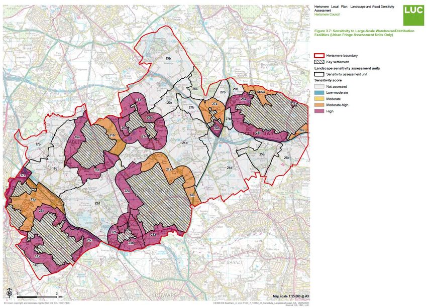
There are significant benefits to the allocation of the site, including:
   •   Redevelopment of a soon to be vacant previously developed site
   •   Significant need for commercial sites borough and county
   •   Significant job creation
   •   Substantial economic benefits generated
   •   Defendable Green Belt Boundary
   •   Location within the strategic road network
   •   Strong boundary landscaping
   •   Deliverable land ownership position
   •   Substantial occupier interest

Ownership
Regen Properties LLP are in control of the single ownership of the site, and no
further land assembly is required for the site delivery. The site can be brought
forward early in the plan period to meet the acute need for commercial space.
Regen Properties LLP would be happy to submit an application during the plan
production/examination process to demonstrate the schemes deliverability and
our commitment to the scheme.

The Opportunity
Regen Properties LLP have had detailed discussions with several potential major
national and international online retailers, distributors and employers. The site
has the potential to accommodate B8 users with ancillary offices. The site is
ideally located given its ease of access to the strategic road network, including
the M1, M25, A1, and A41, providing direct links to London, the South East and
the Midlands. In addition to a strong local workforce.

                                         3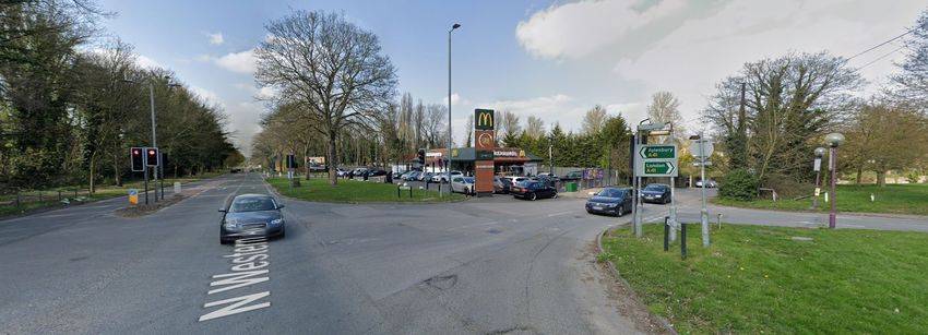
2. The Site
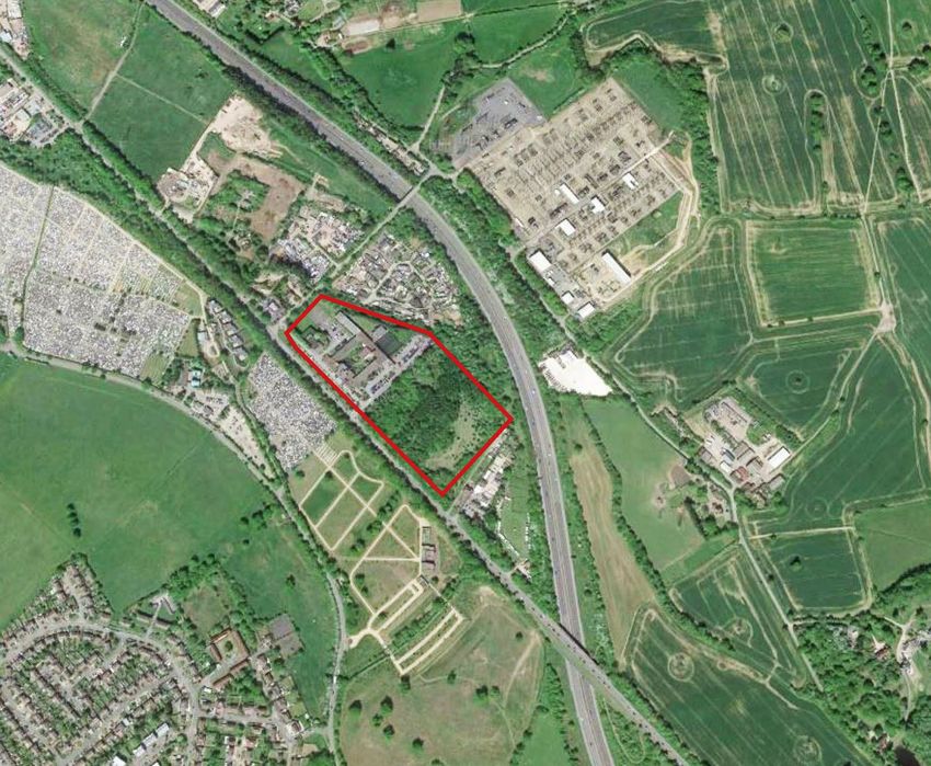
The Site
The site is located beyond the eastern edge of Bushey, between the A41 Watford
Bypass and the M1 motorway. The site is bounded to the north by the Hilfield
Brook stream, to the east by the A41 and Sandy Lane, and to the south and
west, the National Animal Welfare Trust, and Hilfield Brook. The site has an area
of 6.71 hectares.
The site is located within the Green Belt and is occupied by the Mercure Hotel
with substantial hardstanding including car parking and sport pitches, associated
green space to the south. The green space is overgrown, although was
historically partially cleared, and is not accessible to the public. The condition of
the hotel buildings is in significant decline.
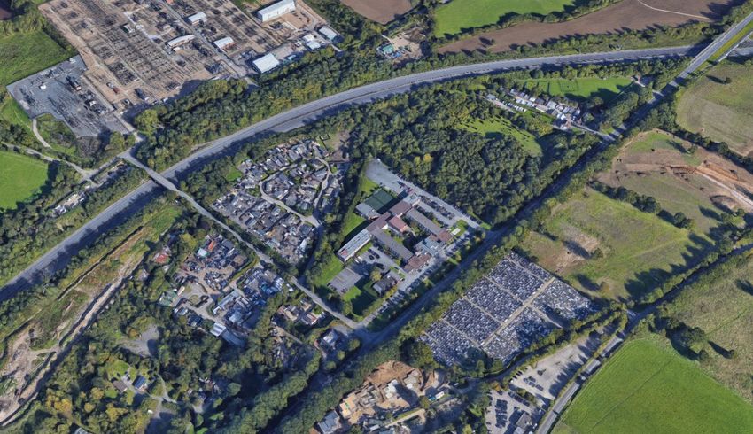
Figure 1: Aeriel View Site Location
4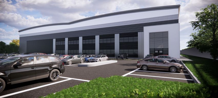
In terms of gradients, the site level has a slight fall from the level of the A41
road towards the Brook, although surfaces have been levelled for the access road
and car parking. The north-west of the site includes the hotel buildings, which
comprise the main hotel which is set out in a quadrangle form with courtyard,
and wings on the northern and west edges. The hotel ranges from two storey to
three storey height, with the difference reflecting the variation in gradient on the
site.

The portion of the site to the south and east of the hotel buildings is an area of
semi-mature trees with clearings. This area of the site has previous planning
history, including an implemented consent for a golf course, tennis courts and a
clubhouse with car parking. A plan showing this approval is illustrated in Figure
2. Historical aerial photographs suggest clearing work was undertaken for the
proposal, and there is evidence of trenches for foundations.

Figure 2: Implemented consent for the golf course and sports facilities (1989)

                                                                   5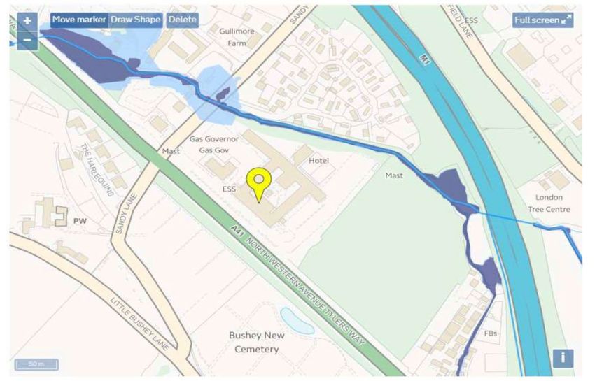
The proposal was implemented, and therefore the south-west portion of the land
is previously developed land within the curtilage of the hotel.

Planning History
The site has a substantial planning history (full history provided in Appendix 1),
with the first reference on the online planning register being extensions to the
'Spiders Web Hotel' in the 1970s. The key permissions are as follows:
   •   First-floor extension (1978)
   •   Staff block (1979)
   •   Renewal of consent for first-floor extension (1983)
   •   New office (1984)
   •   Façade improvements (1988)
   •   A new block including squash courts (1988, revised 1989)
   •   72 bedroom extension (1989)
   •   Rebuild of a portion, providing ten new rooms (1989)
   •   Bar and restaurant (1989)
   •   Change Of Use Of Agricultural Land To 9 Hole (Par 3) Mini-Golf Course
       With Floodlit Tennis Courts Club House And Ancillary Car Parking (1989)
   •   Two storey extension (1990)
   •   Change of use of bedrooms to conference facilities (1993)
   •   Erection of entrance canopy (1995)
   •   29 bedroom extension and extended restaurant and bar, with internal
       road link (1999), an extension of time (2005, 2006)

                                        6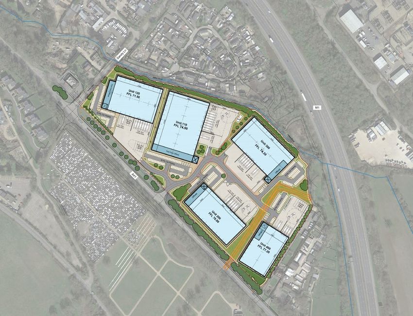
3. The Proposal
Regen Properties LLP seek to secure an allocation for the site for commercial use
and removal from the Green Belt. We have undertaken feasibility work and
believe the site can easily accommodate approximately 30,000 sq metres of
commercial floor space.

This representation is submitted with two masterplans for the site, each showing
different potential configurations of commercial floorspace:
   •   Option 3 comprises five warehouse units, shown in Figure 3, with the main
       access point on the A41 (along with a secondary access point for car
       parking on Sandy Lane). These five units have a combined Gross Internal
       Area (GIA) of 27,681 sqm (equivalent to 297,965 sqft) of floorspace. This
       comprises 24,891 sqm of warehouse space and 2,790 sqm of ancillary
       office space.

   •   Option 4 comprises four warehouse units, shown in Figure 4, with the
       largest warehouse (Unit 100) located to the north west of the site. As with
       Option 3 the main access point is on the A41 and there is a secondary
       access point for car parking on Sandy Lane. These four units have a
       combined GIA of 28,436 sqm (equivalent to 306,090 sqft) of floorspace.
       This comprises 25,694 sqm of warehouse space and 2,743 sqm of ancillary
       office space.

The key layout and design principles that have informed these layouts, include:
   •   Vehicular access off the A41, within the western previously developed
       part of the Site;
   •   Highway safety improvements including the re-positioning of Sandy Lane
       entrance away from main junction removing potential conflicts;
   •   Retention of a minimum 20m wide band of vegetation along the southern
       edge of the woodland, retaining the mature oak trees and forming a
       strong visual screen to development in this part of the Site;
   •   Lowering the ground levels within the interior of the Site to reduce the
       overall height of the new buildings;
   •   Retention of the line of semi-mature specimen trees along the southern
       edge of the hotel area, as these trees contribute to the street scene
       along the A41;

                                        7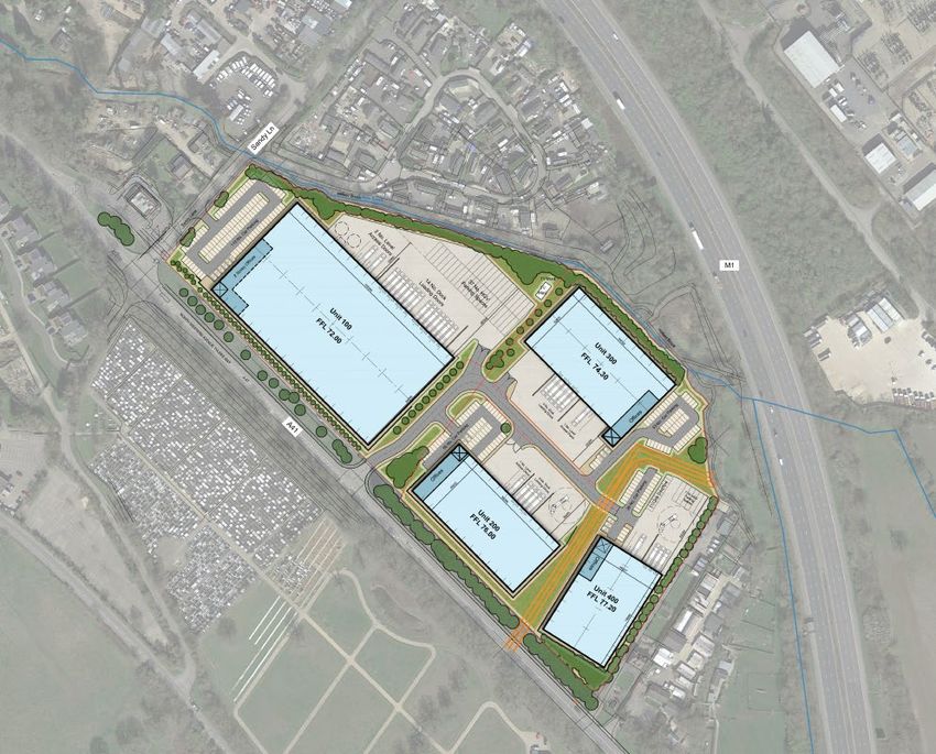
•    Retention and strengthening of existing boundary vegetation to the
          northern, western and eastern Site boundaries where possible to screen
          views from adjacent properties; and
     •    Provision of new tree and shrub planting to break up the office parking
          areas and within the incidental open spaces.

Figure 3: Option 3 Building Masterplan

                                          8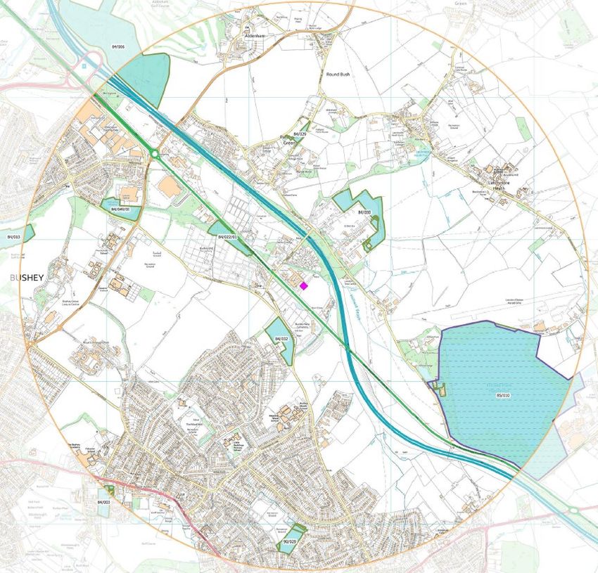
Figure 4: Option 4 Buildings Masterplan

Figure 5: Option 3- 3D Perspective

                                          9
Figure 6: Option 4 - 3D Perspective
Figure 7: Computer Generated Image
Figure 8: Computer Generated Image
10There is potential for the site to be utilised within the land use class of B8 for
storage and distribution. The B8 units would also include ancillary office functions
as appropriate to a warehousing development.
The masterplans demonstrate that the development can be easily
accommodated on site with space for parking, manoeuvring and substantial
landscaping.
The development provides an opportunity to provide a comprehensive
landscaping scheme that would involve tree planting and retention across the
perimeter of the site, including the northern part of the site which currently
includes the built form. The landscape scheme would be in the form of a 'green
buffer', which would screen the site from the residential area opposite Hillfield
Brook, and from the National Animal Welfare Trust. The green buffer function
would be aided by maximising the potential for retention of the existing trees
along the site perimeter. A 20m band of retained woodland along the southern
edge next to the A41.
The site location is disconnected from the wider countryside by the major roads,
M1 and A41, residential areas, and a range of non-agricultural land use. The
historical development of the local area is such that the site does not meet with
the NPPF purpose for including land within the Green Belt.
The masterplans illustrate that the site can easily accommodate the proposals.
114. Exceptional Circumstances
The NPPF requires that exceptional circumstances are demonstrated to justify
the release of a site from the Green Belt. This chapter considers the policy
context for this before the statement goes on to demonstrate the exceptional
circumstances and benefits to the scheme.
National Planning Policy Framework
The National Planning Policy Framework (NPPF) (2019) outlines the Government's
position regarding Green Belt land in Chapter 13. Paragraphs 133 and 134 of
NPPF provide commentary in relation to the purpose of Green Belt land.
"133. The Government attaches great importance to Green Belts. The
fundamental aim of Green Belt policy is to prevent urban sprawl by keeping land
permanently open; the essential characteristics of Green Belts are their openness
and their permanence.
134. Green Belt serves five purposes:
a) to check the unrestricted sprawl of large built-up areas;
b) to prevent neighbouring towns merging into one another;
c) to assist in safeguarding the countryside from encroachment;
d) to preserve the setting and special character of historic towns; and
e) to assist in urban regeneration, by encouraging the recycling of derelict
and other urban land."
Paragraph 136 states that once established, Green Belt boundaries should only
be altered where exceptional circumstances are fully evidenced and justified.
Before concluding that such circumstances exist, the plan-making authority
should be able to demonstrate that it has examined all other reasonable options
for meeting its identified need for development.
Sir Duncan Ouseley has recently handed down judgment in the case of Compton
PC, Ockham PC & Cranwell v Guildford BC, SSHCLG & Ors [2019] EWHC 3242
12(Admin), dismissing three challenges to the adoption of the Guildford Local Plan
under s113 of the Planning and Compulsory Purchase Act 2004.
The main issues in the case related to the justification for Green Belt release in
the local plan to provide for a supply of around 14,000 houses when the
objectively assessed need (OAN) was around 10,000 houses.
In considering the requirement in the National Planning Policy Framework that
Green Belt boundaries should only be altered in exceptional circumstances, the
Judge commented:
All that is required is that the circumstances relied on, taken together, rationally
fit within the scope of "exceptional circumstances" in this context. The breadth
of the phrase and the array of circumstances which may come within it place the
judicial emphasis very much more on the rationality of the judgment than on
providing a definition or criteria or characteristics for that which the policy-maker
has left in deliberately broad terms.
There is a danger of the simple question of whether there are "exceptional
circumstances" being judicially over-analysed. This phrase does not require at
least more than one individual "exceptional circumstance". The "exceptional
circumstances" can be found in the accumulation or combination of
circumstances, of varying natures, which entitle the decision-maker, in the
rational exercise of planning judgment, to say that the circumstances are
sufficiently exceptional to warrant altering the Green Belt boundary.
General planning needs, such as ordinary housing, are not precluded from its
scope; indeed, meeting such needs is often part of the judgment that
"exceptional circumstances" exist; the phrase is not limited to some unusual
form of housing, nor to a particular intensity of need.
It is clearly implicit in the stage 2 process that restraint may mean that the OAN
is not met. But that is not the same as saying that the unmet need is irrelevant
to the existence of "exceptional circumstances", or that it cannot weigh heavily
or decisively; it is simply not necessarily sufficient of itself. These factors do not
exist in a vacuum or by themselves: there will almost inevitably be an analysis
of the nature and degree of the need, allied to consideration of why the need
cannot be met in locations which are sequentially preferable for such
13developments, of the impact on the functioning of the Green Belt and its purpose,
and what other advantages the proposed locations, released from the Green Belt,
might bring, for example, in terms of a sound spatial distribution strategy.
The analysis in Calverton P.C. of how the issue should be approached was
described by Jay J as perhaps a counsel of perfection, but it is not exhaustive or
a checklist. The points may not be all matter in any particular case, and others
may be important, especially the overall distribution of development, the scope
for other uses to be provided for along with sustainable infrastructure.
"Exceptional circumstances" is a less demanding test than the development
control test for permitting inappropriate development in the Green Belt, which
requires "very special circumstances."
The phrase "exceptional circumstances" should be considered as a whole, and in
its context, which is to judge whether Green Belt boundaries should be altered
in a Local Plan review. It is not necessary to explain why each factor or the
combination is itself "exceptional". It does not mean that they have to be unlikely
to recur in a similar fashion elsewhere. It is sufficient reasoning to spell out what
those factors are and to reach the judgment. There is a limit to the extent to
which such a judgment can or should be elaborated.
Sir Duncan Ouseley also held that it was lawful to allow headroom or a buffer of
around 4,000 units of supply over OAN, to ensure that need was met and that a
rolling five-year housing land supply was maintained. He concluded that the
prospect that a level of housing in excess of the OAN might be achieved could
contribute to exceptional circumstances for Green Belt release. In light of the
pressing housing problems in Guildford, the Judge recognised that there would
plainly be significant benefits in terms of affordability and affordable housing if
more housing were provided than simply to meet needs.
The Judge concluded that the advantage of a higher level of housing supply could
contribute to exceptional circumstances for Green Belt release. Taken as part
of the whole group array of exceptional circumstances, there was nothing
unlawful about that being seen as a useful or even significant advantage, in line
with NPPF housing policy, and as a contributor to exceptional circumstances.
14The Hertsmere Potential sites for Housing and Employment document states that
regardless of the precise development requirement in the new plan, the Council
expect to have a level of need greater than can be accommodated within our
existing settlements, and so we will need to look to Green Belt sites for the
shortfall. In 2021, the Council launched this additional employment call for sizes
to help identify new sites for employment designations. The proposal site would
help address the identified shortfall.
Hertsmere is 82% Green Belt, and there are few alternatives to development in
the Green Belt. The majority of brownfield sites have already been redeveloped
or are in an active use. The need for Green Belt sites to meet employment needs
is partially recognised in the existing Local Plan, which safeguards land in and
adjacent to the Green Belt for commercial development (Cranborne Road and
Elstree Way). The site on Rowley Lane (Elstree Way) has recently secured
planning consent for the new Sky Studios development and no longer available.
As a result, within the new Local Plan, Green Belt allocations will be required to
meet all the commercial development needs of the Borough.
Within the rest of this report, we will demonstrate that this site is a poorly
performing parcel of Green Belt. That there is a severe need for new commercial
space in Hertsmere and Hertfordshire, and that there a no planning constraints
that restrict this site coming forward for commercial development.
155. Economic Need
Strategic Importance of Industrial, Commercial and Logistics Development
The industrial and logistic sector is increasing in strategic importance. Previous
research undertaken by the British Property Federation, 'Delivering the Goods',
highlights the economic contribution of the sector. Logistics activity currently
accounts for 8% of the UK's workforce, and employment in warehousing
operations has increased by 40% between 2009 and 2013. In terms of salaries,
the average wage has grown at a higher rate (7%) over the last five years than
the national average (3%). The perceptions of the sector are changing.
However, despite the economic contribution of the sector, there is a risk that
the availability of land suitable for industrial uses is declining. Research
undertaken for the report 'Keep London Working' shows that importance of
retaining industrial sites and resisting the loss of sites to housing in London. The
report shows that demand for industrial and logistics space is not just driven by
population growth, but also by changing consumer habits. The UK already has
the largest e-commerce sector in Europe and is estimated to be circa 20% of
total retail trade in 2018.
The GLA in the Draft London Plan takes a protective approach to Strategic
Industrial Land (SIL); the policy has shifted from managed release to "not a net
loss of industrial floorspace". In order to meet the needs of future London
residents, the GLA is also looking to authorities outside of London to assist in
provision. There is a proposed policy of 'substitution'; Local Plans can consider,
in collaboration with neighbouring authorities within and outside London, the
scope to facilitate the substitution of some of London's industrial capacity to
related property markets beyond London's boundary.
The Hertfordshire Local Enterprise Partnership along with LSH, published a study
in February 2019 on the Loss of Employment Space in Hertfordshire. This found
that the industrial sector has witnessed strong demand for industrial space, but
the severe lack of available supply is constraining the market. This is
demonstrated in Figures 9 and 10, which show how industrial vacancy rates have
declined significantly and how little notional 'years' supply' of floor space there
is to cater for demand. New stock is coming forward, but it is insufficient to meet
demand levels. Development opportunities do exist, but difficulties with land
16ownership and assembly are holding back some of these potential schemes.
These factors are driving rental growth, which is reducing the competitive
advantage of the County. However, alongside yield reductions, it is reinforcing
development viability, although opportunities do need to come forward.
Figure 9 Hertfordshire Industrial Vacancy
Figure 10 Years of Industrial Space Supply
17In terms of the industrial sector, Figure 11 summarises the picture for the
industrial sector in Hertfordshire. This shows that there has been a net loss of
approximately 370,500 sq. m. of industrial floorspace over the past decade.
There were gains of approximately 550,000 sq. m. of industrial floorspace over
this period, but this was off-set by the loss of almost 920,480 sq. m. of industrial
floorspace.
Figure 11: Composition of Changes in Stock of Industrial Floorspace in Hertfordshire
Figure 12: Change in Total Stock of Industrial Floorspace in Hertfordshire
18South West Herts Economic Land Study 2019
Hatch Regeneris has identified a need for 481,500 sq m of industrial space
between 2018 and 2036. This can be further divided into 152,000 sq m of B1c/B2
space and 329,500 sq m of B8 space. We estimate this could support around
7,400 new FTEs between 2018 and 2036.
This requirement is based on past trends in the take-up of industrial space in
South West Herts. The target is not aligned with any of the labour-demand or
supply-led scenarios and marks a significant uplift on the estimates from the
2016 study (a net change of 11,300 sq m although this was made up of a fall in
B1c/B2 space of 122,300 sq m and a positive requirement for 133,600 of
warehouse space).
Although this is a considerable change, we believe it is justified by the
consistently strong levels of demand for industrial space in South West Herts,
which could have been even higher if the market was not undersupplied. The
continued growth of online shopping is also likely to mean this strong demand is
sustained.
Figure 13: Indicative distribution of industrial space by district 2018 to 2036
With regard to the need for large scale (c.9,000sqm+) industrial space, the Study
concludes that:
"…These tend to be strategic warehouses occupied by national or global
companies who prioritise access to the strategic road network and look for higher
quality state of the art premises. This market is dominated by Maylands Business
Park which offers good access to the M1. This has an availability rate of 4.7%
indicating a shortage of space.
With such limited space available, it will be very difficult to accommodate
demand for even modest amounts of space. There is therefore a significant
danger that the FEMA will lose out on potential investment. There may also be
19knock-on consequences for productivity if local businesses are dependent on a
supply of local storage and distribution facilities for their supply-chains.
Although there have been a number of recent completions of industrial space,
most notably the Prologis development at Maylands Business Park, overall there
has been a net loss of space since 2008/9 (-195,000 sq m). This represents a
10% decrease in South West Herts' industrial stock since 2008…." (emphasis
added) (South West Herts Economic Study Update 2019 Executive Summary
paragraph xiv-xvi)
The Study notes that the availability rate for industrial space has fallen
dramatically since 2010 when it was 17.4%, further evidencing the existing level
of shortfall in this sector. The potential indirect impacts of not meeting this
demand on the wider economy are also noted and emphasised in the Study; as
set out earlier in this Section, the direct and indirect employment impacts
associated with the ongoing operation of the proposed redevelopment amounts
to in excess of 700 FTE jobs.
When considering future needs, the Study identifies a need for 481,500sqm of
industrial space across South West Herts between 2018 and 2036, of which just
under 330,000sqm would be specifically associated with B8 use (the remainder
would be for B1c/B2 use). Once commitments, allocated sites and
safeguarded/proposed sites are accounted for the Study identifies that there
remains a shortfall of 211,000sqm of industrial space across South West Herts14,
however this should be treated with caution – the true scale of shortfall is likely
to be higher because:
• When identifying supply in allocated sites, the Study (para 8.35) notes
that some sites face significant constraints or face ongoing uncertainty
about how much employment space will be delivered;
• For safeguarded and proposed employment sites there is significant
uncertainty around the East Hemel Hempstead site in St Albans (see Study
para 8.36) because St Albans Council has indicated it would prefer to avoid
an over-concentration of large B8 uses on this site and include a mix of
employment uses including office space (and in any event, the St Albans
Local Plan was withdrawn in November 2020). The Study also raises
concerns that the site is in close proximity to a number of existing
business parks where there is an oversupply of office space and weak
demand, in part due to poor transport connections; and
• Sites included as 'potential future allocations' were still subject to
allocation in emerging local plans, most of which were also currently still
within the Green Belt and would remain so until released through the local
plan process. These sites would subject to Green Belt impact assessments
(amongst numerous other considerations) and there is therefore no
certainty about these sites coming forward.
20In conclusion, the Study finds that supply of employment space in South West
Herts is at "critically low levels" (Study, para 10.9) and that the identified need
for industrial space is justified in light of current demand and future forecasts,
supported by recent trends (which have been accelerated by the Covid-19
pandemic). The Study acknowledges that the forecast need across South West
Herts for industrial space represents significant growth potential, however notes
that previous studies have relied upon forecasts which underestimated growth
in industrial sectors and are inconsistent with recent trends, particularly around
the increases in online retail (this reflects the Hertsmere Core Strategy which,
at the time of being prepared, did not anticipate or plan for significant growth in
the industrial sector). The Study notes that industrial sites will require good
access to the strategic road network.
The proposed redevelopment of the Mercure Hotel site, which amounts to around
28,000sqm of business space, will make a significant contribution to the
industrial land shortfall across the sub-region in a location which benefits from
excellent access to the strategic road network.
Within Hertsmere specifically, the Study identifies an overall need for just under
82,000sqm of industrial space. Notably, the Study finds that there are no
opportunities for intensification or redevelopment on existing industrial sites in
Hertsmere, meaning additional industrial floorspace must come forward through
new sites. 2.39 The most up-to-date evidence therefore indicates the scale of
need and shortfall faced for large scale industrial space in South West Herts
generally and in Hertsmere specifically; this is a shortfall that the proposed
redevelopment of the Mercure Hotel site can help address. The Council's own
evidence has identified that failing to meet this need could have wider economic
consequences as the sub-region misses out on potential investment and local
businesses could have difficulty in their supply chains.
Once supply is taken into account, when compared against the identified need
of 82,000sqm, the Study finds a shortfall of 20,370sqm of industrial space in
Hertsmere; whilst the proposed scheme is evidently larger than the shortfall
identified for Hertsmere alone, it is important to note that:
• The overall shortfall across the Functional Economic Market Area (FEMA –
which comprises the rest of South West Herts) justifies providing this scale
of development. The nature of a FEMA is that it represents the
geographical areas across which people and businesses will migrate in
search of employment and business space. In the case of South West
Herts, the FEMA also corresponds with the Housing Market Area [HMA]
which represents the geographical areas across which individuals generally
search for housing, taking into account factors such as commuting; and
• The Study's assessment of supply in Hertsmere includes 44,800sqm (i.e.
roughly half of the identified need) of safeguarded and proposed sites, a
21significant proportion of which are not allocated and as such remain in the
Green Belt.
The most up-to-date evidence therefore indicates the scale of need and shortfall
faced for large scale industrial space in South West Herts generally and in
Hertsmere specifically; this is a shortfall that the proposed redevelopment of the
Mercure Hotel site can help address. The Council's own evidence has identified
that failing to meet this need could have wider economic consequences as the
sub-region misses out on potential investment and local businesses could have
difficulty in their supply chains.
Economic growth is a priority in local planning policy
The strategic location of Hertsmere for transport and availability of a skilled local
workforce is emphasised in the Hertsmere Local Plan (2012-2027), adopted in
January 2013. It is noted in the current Local Plan that one of the document's
key roles is to "maximise economic development and employment opportunities
in the Borough".
'Policy CS8 Scale and distribution of employment land' states that "The Council
will support development proposals in appropriate locations, which attract
commercial investment, maintain economic competitiveness and provide
employment opportunities for the local community". The Proposed Development
supports these aims of the Council and helps meet these needs now, in a
deliverable form.
Growing the local economy will continue to be a priority in the new Local Plan
Hertsmere has set the early vision and direction of the Local Plan. Which states
a "strong local economy" is a key component of the vision statement for
Hertsmere, alongside being "an attractive and more affordable place to live" and
having a "better environment".
In order to support the vision, the priorities for economic growth include
identifying more sites for development and promoting investment. Amongst
other sectors, jobs in the wholesale, storage and distribution will play a critical
part in delivering growth in the local economy.
22Economic Planning Policy
At a national level, the planning system is expected to play an economic role.
The National Planning Policy Framework (NPPF) and accompanying Planning
Practice Guidance (PPG) set out the Government's statutory planning policies for
England. Both are built around a policy commitment to sustainable development.
In addition to a social and environment objective, the planning system has an
economic objective (paragraph 8):
"an economic objective – to help build a strong, responsive and competitive
economy, by ensuring that sufficient land of the right types is available in the
right places and at the right time to support growth, innovation and improved
productivity; and by identifying and coordinating the provision of infrastructure."
At the heart of the NPPF is a presumption in favour of sustainable development,
which requires local authorities to adopt a positive approach in order to "seek
opportunities to meet the development needs of their area".
The "economic role" of a development is emphasised in the HM Treasury's 'Fixing
the Foundations' report in July 2015, which sets out the plan for increasing
national productivity and creating a more prosperous nation. The plan
establishes the importance of productivity growth alongside increased levels of
employment, which is the key to achieving a stronger nation with richer families
and improved living standards, such aspirations are continued in the recent
planning white paper – 'Planning for the Future' 2020.
The Government's approach to raising national levels of productivity focusses on
two elements:
• Encouraging long-term investment in economic capital, including
infrastructure, skills and knowledge; and
• Promoting a dynamic economy that encourages innovation and
helps resources flow to their most productive use.
The purpose of the 'Modern Industrial Strategy White Paper' is to strengthen the
five foundations of productivity which have been identified by the Government:
ideas, people, infrastructure, business environment and places. The purpose of
the strategy will be to foster collaboration between universities, companies and
entrepreneurs to increase the productivity of the UK economy. The publication
of this White Paper demonstrates the Government's commitment to a holistic
and "joined-up" strategy for the industry.
23Within Hertsmere, there is an acute need for new commercial space both in the
short term. Commercial space needs to be delivered on larger sites, such as
this, to get the sufficient scale buildings to meet occupiers requirements. As a
result, to meet the need Hertsmere need to release Green Belt land to meet this
need. This previously developed site within the Green Belt is a sustainable and
deliverable site which will help meet this need.
Covid Response
Hertsmere Councillors have recently agreed on a strategy setting out how the
Borough's economy will recover from the Covid-19 Pandemic.
The council looked at the impact of the Pandemic on people, businesses and the
town centres and what Hertsmere Borough Council and its partners need to do
over the next five years to recover from this major economic shock.
As well as measures to support businesses and people through the immediate
Pandemic the plan sets out wide-ranging actions to ensure that the economy is
able to respond to new opportunities in green growth, film and television,
technology, sport, clean energy and medical technology. Innovation and skills
are at the heart of the strategy. Given the Borough's strategic position close to
London and within the strategic road network – the Council is well placed to
respond.
This proposal will help support the Council's aspiration to respond to the
Pandemic with a significant increase in new jobs, and economic generation as
set out above.
246. Green Belt and Landscape
CSA Environmental has produced a landscape and visual assessment (March
2021) to support this submission.
Purposes and characteristics of the Green Belt
The NPPF (paragraphs 133 and 134) identifies that the essential characteristics
of Green Belts are their openness and permanence and that they serve the
following five purposes:
a) To check the unrestricted sprawl of large built-up areas.
b) To prevent neighbouring towns merging into one another.
c) To assist in safeguarding the countryside from encroachment.
d) To preserve the setting and special character of historic towns.
e) To assist in urban regeneration, by encouraging the recycling of derelict
and other urban land.
Any harm to the Green Belt, therefore needs to be assessed against these key
characteristics and purposes. As a result, CSA Environmental, the appointed
landscape consultants and ourselves, have assessed the site against these
purposes:
a) Checking unrestricted urban sprawl
The Site is detached from any large built-up area, although it is situated within
a developed parcel of land and represents part brownfield, part infill
development. It plays no role in preventing sprawl of large built-up areas and is
considered to make no contribution to this Green Belt purpose. Importantly
this site is also a previously developed site which is due to become vacant in
late 2021/early 2022.
b) Preventing the merging of towns
The Site forms a small part of a wider gap between Bushey Heath and North
Bushey, and the smaller settlement of Patchetts Green, large parts of which are
already developed, with the M1 motorway also providing a strong separation.
The western part of the Site is previously developed and development of the Site
as a whole result in a negligible change to the existing situation, and would not
lead to coalescence or the perceived merging of settlements when travelling
along the A41. The Site is considered to make a relatively weak contribution to
this Green Belt purpose.
25c) Safeguarding the countryside from encroachment
The western part of the Site is previously developed land occupied by various
hotel buildings, whilst the woodland vegetation visually contains the eastern part
of the Site. The Site also adjoining built development to the east (at Burn Close),
north (at the Sandy Lane Caravan Park) and to the west (along Sandy Lane).
Furthermore, the Site is located within a narrow parcel of land between the A41
and the M1, which physically separate it from the wider countryside. The Site is
considered to make a relatively weak contribution to this Green Belt purpose.
d) Protection of Historic Towns
The Site lies within an area of land between two main roads and does not adjoin
any historic town or Conservation Area. The Site is considered to make no
contribution to this Green Belt purpose.
e) Assisting urban regeneration
The Council's Employment Land (South West Herts) Review clearly identifies
there to be a lack of available and suitable sites outside of the Green Belt to
address identified employment needs in the Borough and to accommodate sub-
regional demand for high-quality logistics development within the M1, M25 and
A41 corridor. Viability issues related to the delivery of brownfield sites for
employment development contributes to this, with land values for employment
generally being insufficient to deliver viable schemes, which leaves them
vulnerable to higher-value uses, notably housing. It is therefore considered that
there is clear evidence to show that a development in the form proposed could
not be accommodated or delivered on any alternative site that would better
assist urban regeneration. The development is therefore considered to create no
harm in relation to this Green Belt purpose.
Permanence and openness
The proposed development would result in some limited harm to the openness
of the Green Belt, given the development of large-scale employment units on a
previously developed site. However, the extent of harm is significantly limited
by the existence of very strong natural boundaries to the site, and the effect
that these boundaries have in defining the character of the site as a contained
tract of land on the urban fringe, rather than as open countryside.
Overall, the Site is assessed as making very little – no contribution to the Green
Belt purposes, and would recycle previously part developed land. The Site could
therefore be released from the Green Belt and/or allocated for development,
26without conflicting with the Green Belt purposes.
Visual Effects
The Site is very well contained by virtue of the dense vegetation to its boundaries
and within the surrounding landscape. Where views are possible from the A41
and Sandy Lane, they look towards the existing hotel buildings and the
vegetation along the southern boundary in the east of the Site.
The new industrial warehouse buildings would be visible from the section of the
A41 which adjoins the southern site boundary, with views from further afield
being restricted by roadside vegetation. The warehouse building in the east of
the Site will be well screened by retained vegetation along the southern Site
boundary.
Views from Sandy Lane and properties on its western edge, adjacent to the Site
boundary, will look towards the new industrial buildings in the west of the Site,
filtered by retained boundary vegetation. New planting along this boundary will
provide further containment and screening of views, as it matures.
A heavily filtered view of the new warehouse building in the east of the Site will
be possible from the adjacent property at Burn Close, although retention and
strengthening of the eastern boundary vegetation will further screen this view,
as it matures.
Heavily filtered views of the new industrial buildings in the west of the Site will
be possible from parts of the Bushey New Jewish Cemetery to the south, during
winter months when vegetation is without leaf cover. These views will be
screened in the summer months.
The proposed development will not be visible in views from the M1 motorway,
with intervening roadside vegetation screening views.
Glimpsed views of the upper sections of the buildings may be possible from the
Sandy Lane Caravan Park to the north, although retained vegetation to the
northern Site boundary will screen the vast majority of these views.
Landscape Effects
The site has been assessed as being of low landscape sensitivity to the proposed
development type, in the western part and medium sensitivity in the eastern
part. The Site Plans illustrate how the proposals have been designed to retain
existing vegetation to the Site boundaries, which will provide strong containment
to the development, particularly in the eastern part of the Site. The majority of
27the interior of the existing woodland would require clearance in order to facilitate
development, although the higher quality oak trees along the southern edge of
the woodland would be retained within a 20m band of vegetation. The Site
boundaries would be reinforced with additional native planting, and new tree and
shrub planting will soften the car parking and incidental open space areas within
the Site.
The character of the Site would undergo some change, as the existing hotel
buildings are replaced with industrial warehouses. However, the well-contained
nature of the Site and limited opportunities for views, together with its location
between two main roads, will mean the effects on the local landscape will be
limited to the immediate confines of the Site, as illustrated in Figure 14.
Figure 14: Aerial perspective of the Site
Landscape Conclusion
The Site forms part of a narrow swathe of land between the A41 and the M1
motorway. It is bound to the east by a cluster of development at Burn Close, to
the south by the A41, beyond which is the Bushey New Jewish Cemetery, to the
west by Sandy Lane and built form along its western edge including McDonalds,
and to the north by the Sandy Lane Caravan Park.
The Site is not covered by any designations for landscape character of quality.
It is not publically accessible, and views of the Site are limited to the immediately
28adjacent roads and properties. The western part of the Site is previously
developed with some scattered trees to its boundaries and car park areas, whilst
the eastern part of the Site comprises an area of woodland. Overall the western
part of the Site is assessed as being of low landscape quality, sensitivity and
value, whilst the eastern part of the Site is assessed as being of medium
landscape quality, sensitivity and value.
Hertsmere has also commission consultants LUC to review the landscape
sensitivity of areas of Green Belt to different forms of development. As illustrated
in Figure 15, the submission site was identified as an area of lower sensitivity
than other edge of settlement Green Belt areas for Warehouse/Distribution
development in Hertsmere. As a result, it is a more appropriate location for
commercial development in the Green Belt than other areas of Hertsmere.
Figure 15: Aerial perspective of the Site
As shown on the Site Plans, the Site could be developed for new industrial
warehouse development, with associated offices. The proposals will retain
existing vegetation to the Site boundaries, including a 20m wide band of
vegetation along the southern edge of the woodland. The majority of the interior
29of the woodland would however, require clearance in order to facilitate
development in the eastern part of the Site. New planting is however, proposed
in the form of native tree planting to strengthen the existing boundaries, and
tree and shrub planting to soften the car parking and incidental open space
areas.
The proposed development will be well contained by boundary vegetation, with
views limited to the immediately adjoining roads and properties along Sandy
Lane and the A41. Retained boundary vegetation will also be strengthened with
new native planting, which will further screen any views as it matures.
Given the Site's location within a largely developed parcel of land between the
M1 and A41, and its part previously developed nature, the Site is capable of
being removed from the Green Belt and allocated for development, without
compromising the objectives and purposes of the Green Belt or impacting on the
wider landscape character of the area.
307. Transport and
Accessibility
EAS Transport Planning has prepared a Transport Review (March 2021), which
demonstrates that the site is highly suitable for being brought forward as a
commercial development from a highways and transport perspective.
EAS have started to model the proposed vehicle movement proposed from the
site; any impact would be within the anticipated day to day traffic variation levels
on the highway network. A full assessment would be undertaken when traffic
flows are considered to be valid for assessment purposes. A form of assessment
has, however, been completed to establish the likely additional traffic in
percentage terms, and this is expected to be 3.8% in each direction at the site
frontage and around 1% or less in the peak hour at the M1 J5 interchange. As a
result, the proposal fully meets the NPPF, Local Transport Plan and the current
Hertsmere development plan
Pedestrian and cycle connectivity will be improved. At present, there is no facility
to cross the A41 at the traffic signals at the junction of Sandy Lane. The
rationalisation of road space afforded by the closure of the northern access into
the site would assist with the implementation of a crossing point and a new
pedestrian/cycle phase in the signal cycle.
This access point would then be relocated further east along Sandy Lane so that
it is further away from the A41 solving current negative traffic interactions. This
new access point would be to a car park only, and so no large vehicles would
use this better-positioned access point.
A continuous pedestrian route could then be implemented linking the existing
cycle route on the western side of the A41 to the site and eastwards along Sandy
Lane, also allowing pedestrian and cyclist access to the McDonalds restaurant
and the permanent residential caravan site etc.
31The rationalisation of the highway will improve the efficiency of the signal
junction operation, and the benefits described would most likely improve road
safety. It is noted that there have been a number of slight accidents in the
vicinity of this junction.
The main access point for HGV use would remain more or less at the current
position, which has been shown to be very safe. There have been no accidents
recorded in the past five years, and junction visibility is very good. As a fall back
position, this access may also be converted to a signalised junction that could
also incorporate a pedestrian and cycle crossing stage. In this eventuality, both
junctions would be linked, and a new controller would be implemented,
potentially working on a SCOOT system.
Regen Properties LLP are undertakening ongoing highways pre-application
discussions with Hertfordshire County Council who have stated:
HCC consider the site well situated to comply with Policy 16 (Freight and
Logistics) of LTP4. However, due to the lack of bus service provision and the
restricted car parking proposed it is essential that other methods of sustainable
travel (walking, cycling, car share etc.) are maximised through a Travel Plan to
ensure compliance with the remaining policies of LTP.
Figure 16: Aerial perspective of the junction
32Figure 17: Streetview perspective of the junction
The proposed highway amendments associated with the development are
beneficial in highways and transport terms and offer significant improvements to
local network while being compliant with national and local policies. The
improvement of the existing and potential varied junction arrangements would
improve road safety and significantly improve crossing connectivity for
sustainable modes which is lacking at this point of the highway network,
where the east and west side of the A41 are currently effectively severed to non-
motorised users. There is, therefore, no highways or transportation reason why
the proposed development should not be considered favourably in the Local Plan
review process.
338. Flood Risk
This representation is submitted with a Flood Risk and Drainage Site Appraisal
from consultants EAS (March 2021).
According to the Environment Agency Flood Map for Planning inset below, the
majority of the site is located in Flood Zone 1 with a minor area of Flood Zone
2 located. The area in Flood Zone 2 will not be subject to any development
and therefore does not present a concern for this style of development. In
any event a 'B8 land use' is a 'less vulnerable' land use in terms of EA
guidance.
Figure 18: Extract of the EA Flood Map for Planning
It should be noted that the Environment Agency Long Term Flood Risk map,
inset below, shows the site to be located in a reservoir flood extent, in this
instance sourced from the Hillfield Park and Aldenham Reservoirs located
approximately 1.5km to the south east of the site. This extreme flood event
would mean that the reservoir would have failed. Reservoirs are subject to
rigorous inspections and are designed to the standards as set out in the
Reservoirs Act. It is not possible to have a prior warning of a failure of this
type, and for this reason, it has been considered a 'residual risk'. This is, of
course, a very low likelihood.
34Figure 19 Flood Risk from Surface Water map
There are sporadic areas within the existing site shown to be at high risk of
surface water flooding however the site is largely at very low risk. Alterations
to the site layout and levels alongside the introduction of a sustainable and
effective surface water drainage strategy is likely to alleviate if not eliminate
the identified surface water flooding. Groundwater flooding has not been
identified as an issue at the site however site-specific investigations would
inform groundwater levels at the site. Overall, no significant flood risks which
cannot be mitigated or managed have been identified.
Preliminary attenuation calculations have been undertaken at this stage using
site layout Option 3. The geology of the site alongside its proposed use means
infiltration has not been pursued. In the absence of surface water sewers and
in line with the SuDS hierarchy, it is proposed to have a restricted outfall to
the Hilfield Brook. The initial calculation show that there is ample storage
available on site to restrict flow to the QBAR greenfield runoff rate.
At present the attenuation storage has been provided by attenuation tanks
and permeable paving however above ground features need to be provided
on site. These features will be able to provide the needed water treatment
stages prior to the outfall to the brook.
35The surface water drainage strategy should include features that improve
water quality, biodiversity, amenity and habitat creation. The proposed
drainage strategy should provide the required water treatment stages as
outlined in Table 26.2 of the CIRIA SuDS Manual C753. There are
opportunities within the proposals to improve water quality and reduce runoff
when compared to the existing site.
Figure 20 Preliminary Surface Water Drainage Scheme
Consultation with Thames Water regarding foul sewer capacity is currently
underway.
In conclusion, the proposals adhere to the NPPF with regards to flood risk. It
is likely that this proposal would reduce the severity of flooding at the north
eastern corner of the site as runoff from the site will be considerably lower
than that which exists at present. There are also practical and sustainable
solutions for the surface water drainage. There is no reason from a flooding
and drainage perspective for this site not to be allocated in the forthcoming
Hertsmere Local Plan.
369. Ecology and Trees
CSA Environmental have undertaken produced an Ecological Overview (March
2021) to support this submission.
Within their report, they note that no impacts to nature conservation
designations are predicted as a result of commercial development of the Site,
subject to the provision of open space which is proposed to the south of the site
and informally to the north.
The western parcel (Mercure Hotel) of the Site comprises previously developed
land of limited intrinsic ecological interest. Subject to appropriate protections of
notable grassland, and native trees, development of this portion of the Site is
unlikely to give rise to significant adverse effects in respect of ecology.
The eastern parcel of the Site comprises both scrub wooded and open habitats
anticipated to support a range of fauna. The loss of this secondary woodland
habitat, whilst undesirable, could be mitigated for through the creation of more
extensive and/or diverse woodland habitat off-site, to ensure accordance with
the National Planning Policy Framework (NPPF, 2019). Furthermore, such
intervention could be designed and implemented to deliver biodiversity benefits
in excess of the mitigation requirements, and thereby align with future
Biodiversity Net Gain (BNG) requirements. Such an approach would need to fully
document that mitigation hierarchy has been accorded with, and that all
opportunities to minimise impacts are taken. It is likely that any off-site
mitigation/compensation would need to allow for measures in respect of
protected and/or notable fauna subject to the findings of further survey works,
which are currently underway.
Overall, given the Site's urbanised and isolated context, and the nature of the
recently established habitat, providing new habitat that is better integrated into
the local ecological network would, in-time, deliver greater benefits for
biodiversity than leaving the site undeveloped.
Further survey work is underway and the results of these surveys will be shared
with the Council at the appropriate times:
37• Detailed botanical survey and Habitat Condition Assessments
• Bat surveys: Preliminary Roost Assessment (PRA) of Structures and Trees;
Nocturnal Bat Roost Surveys of Structures and Trees; Remote Monitoring
of Bat Activity
• Breeding Bird Surveys
• Otter and Water Vole Surveys
• Badger Survey
• Reptile Surveys
Figure 21 Ecological Sites
Consultants DCCLA (March 2021) have reviewed the trees on site. There are no
protected trees on the site. A tree note is submitted with this representation and
makes conclusions and recommendations. In terms of the hotel area, the trees
38are low quality or unremarkable trees as set out within BS 5837:2012. However,
trees along the site boundaries provide screening to the existing development
and any proposed development and should be retained where possible. The
consultant notes recommend that trees are retained and planted at site
boundaries to assist with screening.
There are, therefore, no ecology or arboricultural reasons why the proposed
development should not be considered favourably in the Local Plan review
process.
3910. Heritage
The site does not contain any listed buildings or locally listed buildings. Nor is it
within a conservation area. The site is also not an area of archaeological interest.
The nearest heritage assets are located on Hilfield Lane, which is the opposite
side of the M1 motorway and as a result, would be unaffected by the proposals.
Figure 22: Heritage Assets
Therefore, this proposal will have no impact upon heritage asset and is policy
compliant with the NPPF and current Local Plan. The proposed development
should be considered favourably in the Local Plan review process.
40You can also read